Spatial Decision-Support for National Marine Conservation Areas in the Southern Strait of Georgia and Gwaii Haanas
|
|
|
- Henry Dickerson
- 5 years ago
- Views:
Transcription

1 Spatial Decision-Support for National Marine Conservation Areas in the Southern Strait of Georgia and Gwaii Haanas Lindsay McBlane Krista Royle Greg MacMillan Photo: Mark Hiebert Western and Northern Service Centre Parks Canada

2 Presentation Outline A. Introduction - NMCAs - Projects Purpose - Marxan - Development of a Zoning Plan B. Project Tasks - Develop Operation Principles - Collate Biophysical Data - Collate Socio-Economic Data - Identify Areas that are important to conserve marine biodiversity C. The Road Ahead Photo: Lindsay McBlane


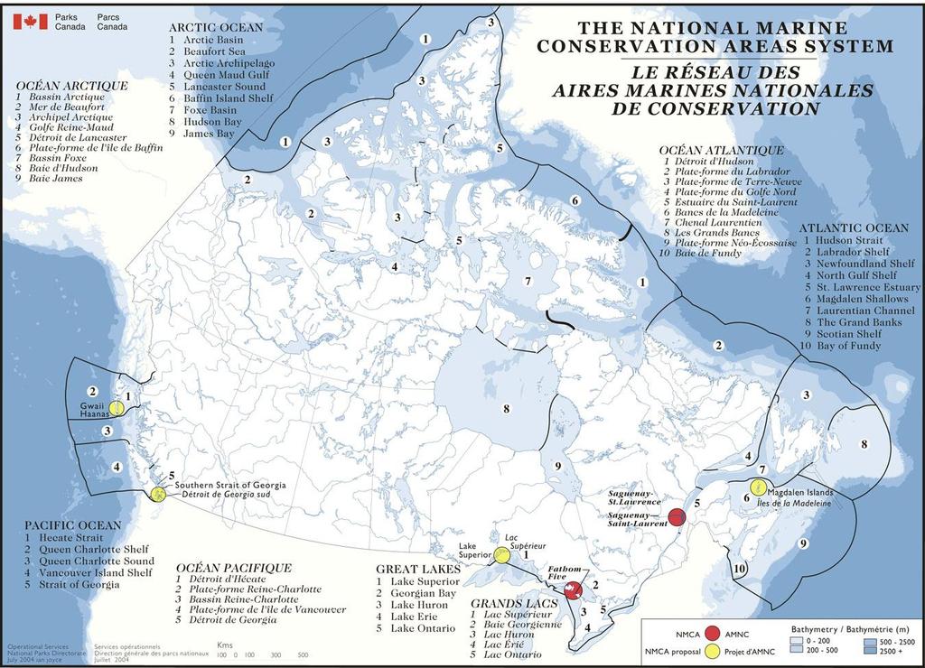
3 What is an NMCA? The NMCA Act was passed in 2002 which provides the mechanism to establish a network of marine conservation areas across Canada NMCAs will have multiple use zones includeing fully protected and ecologically sustainable use. Includes seabed, subsoil and water column. Non-renewable resource exploration and extraction will be prohibited Any modifications to fishing or marine navigation/safety requires an agreement with the respective managing authority. Photos: Lindsay McBlane
4
")
 Identification")
 Delineation")
 Assist in the creation of a zoning")
5 Introduction The purpose of these projects is to aid in the (1) Identification of areas of high conservation values (2) Identification of areas of importance to resource use and visitor experience (3) Delineation of options for fully protected zones (4) Assist in the creation of a zoning plan Photos: Tomas Tomascik
6 What is Marxan? Globally recognized decision-support tool Developed by researchers at the University of Queensland to deliver decision support for conservation area design What does Marxan do? Identifies a group of sites which meet conservation targets for a range of biodiversity features for a minimal cost Marxan scores various combinations of areas (planning units) that could potentially contribute to the conservation area. Marxan does not provide final answers but it is a tool that is used to support decision-making

7 Benefits of using Marxan Supports a systematic, transparent and scientific approach to NMCA design Able to incorporate different kinds of data Generates a range of solutions Solves complex reserve design problems involving a large amount of data User defined data, conservation targets, and input parameters

8 Tasks involved in the Development 1 of a Zoning Plan Project Team


9 Task 1: Develop Operating Principles Step A: Develop Biophysical Operating Principles Ensure representation of all ecosystems and conservation elements Ensure representivity of special or unique places, attributes or processes Photos: Tomas Tomascik

10 Task 1: Develop Operating Principles Step B: Develop Social, Economic, Cultural Operating Principles Minimize negative socio-economic impacts on stakeholders and local communities Have a consultative process


11 Task 2: Collate Biophysical Data Step A: Create List of Conservation Features Ensure a broad range of habitats, biological features and distinctive areas are protected in fully protected zones Photo: Mark


12 Task 2: Collate Biophysical Data Step B: Collate/Prepare Habitat Data

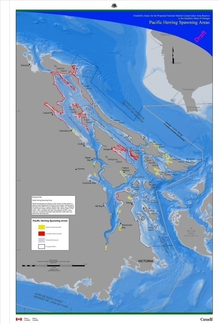
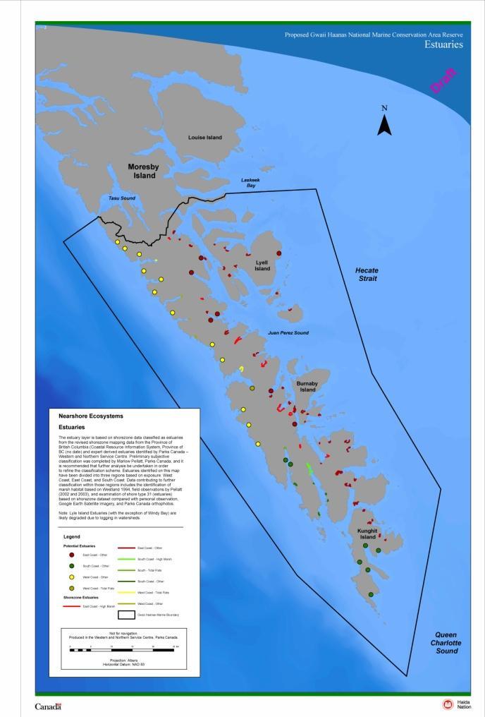
13 Task 2: Collate Biophysical Step C: Collate Biological Data


14 Task 3: Collate Socio-Economic & Cultural Data Data Includes: Recreational Uses Commercial Uses Marine and Foreshore Tenures Cultural Sites Public Values

15 Task 4: Identify Areas that are Important to Conserve Marine Biodiversity Step A: Set Conservation Targets Tell Marxan how much of each feature to capture in the solution Approach based on recommendations from the NMCA Science Network Targets for habitat features were governed by natural marine region distribution Targets for biological features were more aggressive if species and habitats are rare or provincially listed (blue or red) and not widely distributed within the boundary of the NMCA Photo: Mark Hiebert

16 Task 4: Identify Areas that are Important to Conserve Marine Biodiversity Step B: Prepare Marxan Divide Study Area into Planning Units Record amount of each biophysical feature in each planning unit Sensitivity Test Marxan input parameters

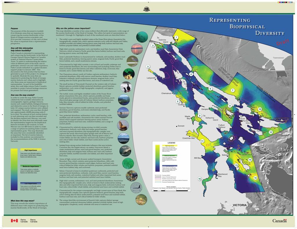
17 Task 4: Identify Areas that are Important to Conserve Marine Biodiversity Step C: Run Marxan First iteration of the Marxan analysis Marxan was run 400 times in order to create a range of options The map shows the number of times each planning area was selected Reveals the relative importance of different areas in meeting our representation mandate

18 Task 4: Identify Areas that are Important to Conserve Marine Biodiversity Step D: Interpret Marxan Results The yellow areas efficiently represent a wide range of habitats, species, and distinctive areas Not all areas with biodiversity values show up as highly important. This does not mean the blue areas do not represent important values Analyzed what values were captured in all yellow areas
19
 Results should not be interpreted")


20 Task 4: Identify Areas that are Important to Conserve Marine Biodiversity Step D: Interpret Marxan Results (cont d) Results should not be interpreted as blueprints for where the fully protected zones Results do not account for socio-economic or cultural information nor do they consider inputs from the consultation process Selection of fully protected areas in an NMCA will be completed through interim and full management planning based on all available information

21 The Road Ahead Modify biophysical component with new and up to date information Add in socio-economic component in the development of a zoning concept Begin extensive consultation with First Nations, other government bodies, stakeholders, and the public Create a zoning plan Ultimately, the final zoning plan will be a negotiated solution that insures sufficient balance of ecological objectives and socio-economic and human interests Photo: Mark Hiebert Photo: Mark Hiebert
 666-2368 Krista Royle krista.royle@pc.gc.ca (604) 666-1986 Greg MacMillan greg.macmillan@pc.gc.ca (604) 666-3431 Photo: Lindsay McBlane")
22 Contact Information Parks Canada Agency Western and Northern Service Center Vancouver, BC Lindsay McBlane (604) Krista Royle (604) Greg MacMillan (604) Photo: Lindsay McBlane
Designing Networks of Marine Protected Areas in DFO s Three Atlantic Bioregions
 Designing Networks of Marine Protected Areas in DFO s Three Atlantic Bioregions Presentation for Indigenous Protected Areas Workshop Max Westhead, DFO and Adrian Gerhartz-Abraham, Dalhousie March 29, 2017
Marine Spatial Planning: A Tool for Implementing Ecosystem-Based Management
 Marine Spatial Planning: A Tool for Implementing Ecosystem-Based Management Steven Murawski, Ph.D., Ecosystem Goal Team Lead National Oceanic and Atmospheric Administration NOAA November 16, 2009 1 To
Overview of Methods. Terrestrial areas that are most important for conservation Conservation
 Overview of Methods The goal of the Western Lake Erie Coastal Conservation Vision project (WLECCV) is to define where we should be working locally to optimally achieve regional conservation impact. The
Outline National legislative & policy context Regional history with ESSIM ESSIM Evaluation Phase Government Integration via RCCOM Regional ICOM Framew
 What MSP Implementation could change in the Maritimes Region Tim Hall, Regional Manager Oceans and Coastal Management Division Ecosystem Management Branch Fisheries and Oceans Canada Maritimes Region BIO
EcoServ-GIS. EcoServ GIS Stage I. Why EcoServ GIS? 17/12/2012
 EcoServ-GIS Ecosystem Services Mapping: A Wildlife Trust GIS Toolkit to map ecosystem services at a county scale Dr Jonathan Winn Living Landscape Coordinator Durham Wildlife Trust Dr Chloe Bellamy Ecosystem
Haida Gwaii Queen Charlotte Islands
 Haida Gwaii Queen Charlotte Islands H E R I T A G E T O U R I S M STRATE GY January 2003 Haida Gwaii/Queen Charlotte Islands Heritage Tourism Strategy Working Group The Haida Gwaii/Queen Charlotte Islands
Marine Spatial Planning as an important tool for implementing the MSFD
 Marine Spatial Planning as an important tool for implementing the MSFD Risto Kalliola Tallinn, Nov. 16 th 2012 DEPARTMENT OF GEOGRAPHY AND GEOLOGY University of Turku, Finland Ten principles to provide
WELCOME & INTRODUCTION
 MPA Management Capacity Building Training Module 1: WELCOME & INTRODUCTION Participants Distinguished Guests Welcome Site Overviews of MPAs represented Overview of Training Program What are Today s Objectives?
SPLAN-Natura Towards an integrated spatial planning approach for Natura th January, 2017 Brussels. Commissioned by DG Environment
 SPLAN-Natura 2000 Towards an integrated spatial planning approach for Natura 2000 Commissioned by DG Environment 17 th January, 2017 Brussels V. Simeonova (Ph.D.) Drivers towards integrating Biodiversity
Mapping and Assessment of Ecosystems and their Services
 Mapping and Assessment of Ecosystems and their Services ALTER-Net Conference 2013: Science underpinning the EU 2020 Biodiversity Strategy. April 2013 Gent Joachim MAES 1 This presentation is based on the
Marine Spatial Planning Leslie-Ann McGee Battelle Memorial Institute
 Marine Spatial Planning Leslie-Ann McGee Battelle Memorial Institute Rev061708 1 Marine Spatial Planning What is it? Why is it different? Where is it currently being employed? What is happening in the
National Land Use Policy and National Integrated Planning Framework for Land Resource Development
 Title National Land Use Policy and National Integrated Planning Framework for Land Resource Development Duration: 32 Weeks Objective: Adoption of appropriate land use planning approaches to: Maintain the
Marine Protected Area Network Planning in the Bay of Fundy and Scotian Shelf. Progress to date and next steps
 Marine Protected Area Network Planning in the Bay of Fundy and Scotian Shelf Progress to date and next steps Max(ine) Westhead, M.Sc. Section Head, Protected Areas and Conservation Planning Fisheries and
EcoServ-GIS. Ecosystem Services Mapping: A Wildlife Trust GIS Toolkit to map ecosystem services at a county scale
 EcoServ-GIS Ecosystem Services Mapping: A Wildlife Trust GIS Toolkit to map ecosystem services at a county scale Dr Jonathan Winn Living Landscape Coordinator Durham Wildlife Trust Dr Chloe Bellamy Ecosystem
BALANCE WP4: Development of a Baltic Sea marine area management framework. - with key inputs from WP1, WP2 & WP3
 BALANCE WP4: Development of a Baltic Sea marine area management framework - with key inputs from WP1, WP2 & WP3 BALANCE Kick-Off meeting, Copenhagen, 31 Aug-1 Sept 2005 Contents of the presentation: 1.
HELSINKI COMMISSION Baltic Marine Environment Protection Commission
 HELSINKI COMMISSION Baltic Marine Environment Protection Commission HELCOM RECOMMENDATION 24/10 Adopted 25 June 2003, having regard to Article 20, Paragraph 1 b) of the 1992 Helsinki Convention IMPLEMENTATION
NORTH VANCOUVER ISLAND MARINE PLAN: OVERVIEW 2015
 NORTH VANCOUVER ISLAND MARINE PLAN: OVERVIEW 2015 North Vancouver Island Marine Plan Overview Refers to: Marine Planning Partnership Initiative. 2015. North Vancouver Island Marine Plan. Copyright 2015
Applying GIS to Coastal Management in Cork Harbour: the Corepoint experience
 Applying GIS to Coastal Management in Cork Harbour: the Corepoint experience Kathrin Köpke University College Cork, Ireland Thematic Conference: THE WATERFRONT MANAGEMENT AND GI (IT), 14 th -18 th November
The National Spatial Strategy
 Purpose of this Consultation Paper This paper seeks the views of a wide range of bodies, interests and members of the public on the issues which the National Spatial Strategy should address. These views
Terms of Reference for the Comparative Environmental Review (CER) of. Options for the Mactaquac Project, Mactaquac, New Brunswick
 of. Options for the Mactaquac Project, Mactaquac, New Brunswick") Terms of Reference for the Comparative Environmental Review (CER) of Options for the Mactaquac Project, Mactaquac, New Brunswick Preamble The New Brunswick Power Corporation ( NB Power ) operates the Mactaquac
Terms of Reference for the Comparative Environmental Review (CER) of Options for the Mactaquac Project, Mactaquac, New Brunswick Preamble The New Brunswick Power Corporation ( NB Power ) operates the Mactaquac
COASTAL ZONE MANAGEMENT AS STRATEGY FOR PRO-POOR LAND MANAGEMENT AND ADMINISTRATION
 COASTAL ZONE MANAGEMENT AS STRATEGY FOR PRO-POOR LAND MANAGEMENT AND ADMINISTRATION COASTAL ZONE MANAGEMENT AS STRATEGY FOR PRO-POOR LAND MANAGEMENT AND ADMINISTRATION INTRODUCTION COASTAL / MARINE SPACES
Parks Canada s Geomatics Infrastructure
 Parks Canada s Geomatics Infrastructure Esri Canada User Conference Ottawa, Canada -- October 15, 2014 Presented By: Brock Fraser National Geomatics Coordinator, Parks Canada. Parks Canada Protects and
Identifying Sensitive Marine Areas: A tour of the legal and scientific criteria
 Identifying Sensitive Marine Areas: A tour of the legal and scientific criteria CIL High Seas Governance: Gaps and Challenges Panel 1 on Sensitive Marine Areas 24-25 April 2017, Singapore Youna Lyons,
Planning for the Shoreline
 Planning for the Shoreline A Summary of the roundtable discussion at Georgia Strait Alliance s second Waterfront Forum June 23, 2014 SFU Harbour Centre Vancouver, BC Planning for the Shoreline Georgia
EBA Engineering Consultants Ltd. Creating and Delivering Better Solutions
 EBA Engineering Consultants Ltd. Creating and Delivering Better Solutions ENHANCING THE CAPABILITY OF ECOSYSTEM MAPPING TO SUPPORT ADAPTIVE FOREST MANAGEMENT Prepared by: EBA ENGINEERING CONSULTANTS LTD.
ESTIMATING THE SOCIAL & ENVIRONMENTAL EFFECTS OF ADVENTURE TOURISM AND RECREATION ON CROWN LAND IN BRITISH COLUMBIA
 ESTIMATING THE SOCIAL & ENVIRONMENTAL EFFECTS OF ADVENTURE TOURISM AND RECREATION ON CROWN LAND IN BRITISH COLUMBIA Wolfgang Haider School of Resource and Environmental Mgt. Simon Fraser University Burnaby,
Local Area Key Issues Paper No. 13: Southern Hinterland townships growth opportunities
 Draft Sunshine Coast Planning Scheme Review of Submissions Local Area Key Issues Paper No. 13: Southern Hinterland townships growth opportunities Key Issue: Growth opportunities for Southern Hinterland
Outline. - Background of coastal and marine conservation - Species distribution modeling (SDM) - Reserve selection analysis. - Results & discussion
 - Reserve selection analysis. - Results & discussion") Application of GIS for data preparation and modeling for coastal and marine conservation planning in Madagascar Rija Rajaonson Technical Assistant, REBIOMA Wildlife Conservation Society Madagascar Outline
Application of GIS for data preparation and modeling for coastal and marine conservation planning in Madagascar Rija Rajaonson Technical Assistant, REBIOMA Wildlife Conservation Society Madagascar Outline
Biodiversity and Protected Areas Management Project
 Biodiversity and Protected Areas Management Project Technical Advisor ESA region: Selwyn Willoughby Coordinator ESA region: Christine Mentzel FlexiCadastre EMEA Regional User Conference, Cape Town, South
A TOOLKIT FOR MARINE SPATIAL PLANNING Version: 17 July, 2009
 A TOOLKIT FOR MARINE SPATIAL PLANNING Version: 17 July, 2009 NEED FOR MARINE SPATIAL PLANNING The health of marine ecosystems is declining, and use conflicts in the marine environment are increasing, in
Key Indicators for Territorial Cohesion & Spatial Planning Stakeholder Workshop - Project Update. 13 th December 2012 San Sebastián, Basque Country
 Key Indicators for Territorial Cohesion & Spatial Planning Stakeholder Workshop - Project Update 13 th December 2012 San Sebastián, Basque Country Key Aims Explore the use of territorial data in developing
MARINE STUDIES (MARINE SPATIAL PLANNING & MANAGEMENT) MASTER S DEGREE
 MASTER S DEGREE") MARINE STUDIES (MARINE SPATIAL PLANNING & MANAGEMENT) MASTER S DEGREE Influence, lead and provide decision making support for the management and planning of coastal and marine spaces. PROGRAM DESCRIPTION
MARINE STUDIES (MARINE SPATIAL PLANNING & MANAGEMENT) MASTER S DEGREE Influence, lead and provide decision making support for the management and planning of coastal and marine spaces. PROGRAM DESCRIPTION
Establishment of the Hellenic Ecosystem Services Partnership (HESP) research group: Drafting the national agenda for the implementation of the
 research group: Drafting the national agenda for the implementation of the") Establishment of the Hellenic Ecosystem Services Partnership (HESP) research group: Drafting the national agenda for the implementation of the ES concept in Greece Establishment of the Hellenic Ecosystem
Establishment of the Hellenic Ecosystem Services Partnership (HESP) research group: Drafting the national agenda for the implementation of the ES concept in Greece Establishment of the Hellenic Ecosystem
MARINE STUDIES (MARINE SPATIAL PLANNING & MANAGEMENT) MASTER S DEGREE
 MASTER S DEGREE") MARINE STUDIES (MARINE SPATIAL PLANNING & MANAGEMENT) MASTER S DEGREE Influence, lead and provide decision making support for the management and planning of coastal and marine spaces. PROGRAM DESCRIPTION
MARINE STUDIES (MARINE SPATIAL PLANNING & MANAGEMENT) MASTER S DEGREE Influence, lead and provide decision making support for the management and planning of coastal and marine spaces. PROGRAM DESCRIPTION
Social Values for Ecosystem Services (SolVES)
") Social Values for Ecosystem Services (SolVES) Presented to the Chesapeake Bay Program Scientific, Technical Assessment and Reporting (STAR) Team Meeting Annapolis, Maryland November 5, 2012 US Department
Social Values for Ecosystem Services (SolVES) Presented to the Chesapeake Bay Program Scientific, Technical Assessment and Reporting (STAR) Team Meeting Annapolis, Maryland November 5, 2012 US Department
Arctic ecosystem services: TEEB Arctic Scoping study. Alexander Shestakov WWF Global Arctic Programme 3 December Arctic Biodiversity Congress
 Arctic ecosystem services: TEEB Arctic Scoping study Alexander Shestakov WWF Global Arctic Programme 3 December 20143 Arctic Biodiversity Congress Content 1. Project design 2. Approach 3. Challenges and
Natural Resource Management. Northern Tasmania. Strategy. Appendix 2
 Natural Resource Management Strategy Northern Tasmania 2015 2020 Appendix 2 Appendix 2 Appendix 2. Carbon Planting Spatial Prioritisation In support of this Strategy s development and implementation, work
Possibilities for applying ES assessment results in spatial planning in Latvia
 Possibilities for applying ES assessment results in spatial planning in Latvia Inga Hoņavko LIFE EcosystemServices project manager LIFE Viva Grass seminar, Sigulda, 17.05.2018 Projekts LIFE EcosystemServices,
Land Accounts - The Canadian Experience
 Land Accounts - The Canadian Experience Development of a Geospatial database to measure the effect of human activity on the environment Who is doing Land Accounts Statistics Canada (national) Component
TEEB: The Economics of Ecosystems and Biodiversity Overview of Process, Content and Approach
 TEEB: The Economics of Ecosystems and Biodiversity Overview of Process, Content and Approach Heidi Wittmer TEEBAgriFood writers workshop Paris, 9-10 May 2016 TEEB s genesis Potsdam Initiative Biological
The Arctic Ocean. Grade Level: This lesson is appropriate for students in Grades K-5. Time Required: Two class periods for this lesson
 The Arctic Ocean Lesson Overview: This lesson will introduce students to the Eastern Arctic Region and the benefits of the Arctic Ocean to the people who live in the Far North. This lesson can be modified
ACRONYMS AREAS COUNTRIES MARINE TERMS
 Natura 2000 ACRONYMS AREAS COUNTRIES MARINE TERMS DEFINITION A European network of protected sites under the European Habitats and Birds Directives, aiming to protect the most valuable and threatened European
Fig 1. Steps in the EcoValue Project
 Assessing the Social and Economic Value of Ecosystem Services in the Northern Forest Region: A Geographic Information System (GIS) Approach to Landscape Valuation Principal Investigator(s): Dr. Matthew
EASTERN SCOTIAN SHELF INTEGRATED OCEAN MANAGEMENT PLAN
 Government of Canada Gouvernement du Canada EASTERN SCOTIAN SHELF INTEGRATED OCEAN MANAGEMENT PLAN SUMMARY Photo Credits: Bedford Institute of Oceanography Published by: Oceans and Habitat Branch Fisheries
Towards international cooperation in the development of Marine Spatial Plans for the North Pacific: economic, social, and environmental dimensions
 Towards international cooperation in the development of Marine Spatial Plans for the North Pacific: economic, social, and environmental dimensions A.V. Sereda, V.B. Lobanov V.I. Il ichev Pacific Oceanological
Marine Spatial Planning (MSP): A practical approach to ecosystembased
: A practical approach to ecosystembased") Marine Spatial Planning (MSP): A practical approach to ecosystembased management Erik Olsen, Institute of Marine Research, Norway Fanny Douvere, International Oceanographic Commission Overview Why we need
Marine Spatial Planning (MSP): A practical approach to ecosystembased management Erik Olsen, Institute of Marine Research, Norway Fanny Douvere, International Oceanographic Commission Overview Why we need
PROMOTING NATURE CONSERVATION AND SUSTAINABLE AGRICULTURAL DEVELOPMENT IN THE RURAL AREAS OF HONG KONG
 1 PROMOTING NATURE CONSERVATION AND SUSTAINABLE AGRICULTURAL DEVELOPMENT IN THE RURAL AREAS OF HONG KONG Director of Agriculture, Fisheries and Conservation Dr. LEUNG Siu-fai A STONE S THROW AWAY FROM
LAND CHANGE MODELER SOFTWARE FOR ARCGIS
 LAND CHANGE MODELER SOFTWARE FOR ARCGIS The Land Change Modeler is revolutionary land cover change analysis and prediction software which also incorporates tools that allow you to analyze, measure and
Bighouse = Centre of Traditional Governance 7/18/2011. No Permission Required: Walking the Talk in First Nation Natural Resources Stewardship
 No Permission Required: Walking the Talk in First Nation Natural Resources Stewardship Doug Aberley and Brian Wadhams People in Places Conference / June 28, 2011 / Halifax NS First Nation 1,700 members
Ecosystem Accounting in Canada
 Ecosystem Accounting in Canada François Soulard Environment, Energy and Transportation Statistics Division Statistics Canada A Community on Ecosystem Services: Linking Science, Practice and Decision Making
Cross-border Maritime Spatial Plan for the Black sea - Romania and Bulgaria project
 Cross-border Maritime Spatial Plan for the Black sea - Romania and Bulgaria project in Romania and Bulgaria Plan Presentation A first step in the management of the marine areas of Romania and Bulgaria
The Role of Wilderness in Climate Change Adaptation
 The Role of Wilderness in Climate Change Adaptation A Case Study of the Northern Rockies Greg Aplet, Bo Wilmer Goal: Sustaining Ecosystem Services Sustaining the full suite of benefits we receive from
A GIS Tool for Modelling and Visualizing Sustainability Indicators Across Three Regions of Ireland
 International Conference on Whole Life Urban Sustainability and its Assessment M. Horner, C. Hardcastle, A. Price, J. Bebbington (Eds) Glasgow, 2007 A GIS Tool for Modelling and Visualizing Sustainability
TOWARDS CLIMATE-RESILIENT COASTAL MANAGEMENT: OPPORTUNITIES FOR IMPROVED ICZM IN BELIZE
 TOWARDS CLIMATE-RESILIENT COASTAL MANAGEMENT: OPPORTUNITIES FOR IMPROVED ICZM IN BELIZE CHANTALLE SAMUELS Coastal Zone Management Authority and Institute The Caribbean Community Climate Change Centre VULNERABILITY
Summary Description Municipality of Anchorage. Anchorage Coastal Resource Atlas Project
 Summary Description Municipality of Anchorage Anchorage Coastal Resource Atlas Project By: Thede Tobish, MOA Planner; and Charlie Barnwell, MOA GIS Manager Introduction Local governments often struggle
National Perspectives - Portugal. Margarida Almodovar
 National Perspectives - Portugal Margarida Almodovar margarida.almodovar@mam.gov.pt from base line to the external limit of the continental shelf behind 200 miles and according to UNCLOS definitions Economic
Geospatial Decision Support Tools for Planning of Marine Protected Areas in California
 Geospatial Decision Support Tools for Planning of Marine Protected Areas in California WILL MCCLINTOCK (UNIVERSITY OF CALIFORNIA SANTA BARBARA), MATT MERRIFIELD (THE NATURE CONSERVANCY), SOPHIE DE BEUKELAER
Aboriginal communities strengthen governance with location-based tools in the 21st century
 Aboriginal communities strengthen governance with location-based tools in the 21st century Today, Aboriginal communities are taking advantage of the geomatics technologies that underpin popular online
Whose Brownfields Count? Researching brownfields redevelopment, and living up here in BC s bottom tier
 Whose Brownfields Count? Researching brownfields redevelopment, and living up here in BC s bottom tier http://www.mccuecontracting.com/img/slide-remediation.jpg http://www.snapcarcash.com/wp-content/uploads/2013/09/terrace.jpg
The Establishment of a Database on Current Research in UNESCO Biosphere Reserves: Limitations and Opportunities
 The Establishment of a Database on Current Research in UNESCO Biosphere Reserves: Limitations and Opportunities Pamela Shaw a* Martin F. Price b Taylor Alexander a Rushi Gadoya a Graham Sakaki a Lauren
15 March 2010 Re: Draft Native Vegetation of the Sydney Metropolitan Catchment Management Authority Area GIS layers and explanatory reports
 SYDNEY COASTAL COUNCILS GROUP Inc. C/- City of Sydney Council Level 14, 456 Kent Street GPO Box 1591, SYDNEY NSW 2001 Phone: (02) 9246 7791 Facsimile: (02) 9265 9660 Email: info@sydneycoastalcouncils.com.au
Other effective area based conservation. The case of Colombia
 Other effective area based conservation measures (OECM): The case of Colombia Working group on Complementary Conservation Strategies Clara L. Matallana Humboldt Institute How is Colombia regarding Aichi
Research Programme Polar, Marine and Coastal Systems. Current and future Arctic research priorities of Germany Nicole Biebow, AWI
 Research Programme Polar, Marine and Coastal Systems Current and future Arctic research priorities of Germany Nicole Biebow, AWI Arctic Science and Technology (S&T) Collaboration and Engagement Workshop,
Marine/Maritime Spatial Planning Andrej Abramić
 Marine/Maritime Spatial Planning Andrej Abramić EcoAqua SUMMER SCHOOL: Ecosystem approach to aquaculture 26-29th of October 2015 Research and Technology to enhance excellence in Aquaculture development
LEDDRA an overview. Helen Briassoulis Department of Geography, University of the Aegean Mytilini, Greece
 LEDDRA an overview, and Ecology Harokopion University, Athens, Greece Outline LEDDRA philosophy LEDDRA approach LEDDRA objectives LEDDRA conceptual framework LEDDRA theoretical framework LEDDRA methodological
World Oceans Day 2010 Our oceans: opportunities and challenges
 World Oceans Day 2010 Our oceans: opportunities and challenges Roundtable discussion on the United Nations Convention on the Law of the Sea fifteen years after its entry into force HOW EFFECTIVELY IS UNCLOS
Integrated approaches to the implementation of the Convention on Biological Diversity
 Integrated approaches to the implementation of the Convention on Biological Diversity Actions on ABS in the context of UNESCO Biosphere Reserves Vibeke Jensen, Director UNESCO Liaison Office in New York
CK107 BA in Geographical and Archaeological Sciences
 CK107 BA in Geographical and Archaeological Sciences CK107 BA in Geographical and Archaeological Science Geography and Archaeology are closely related disciplines, concerned with concepts of time and space
Mapping ecosystem services provided by benthic habitats in the European Atlantic Ocean
 Mapping and Assessment Ecosystem Services and Links to Good Environmental Status Mapping ecosystem services provided by benthic habitats in the European Atlantic Ocean Ibon Galparsoro, Angel Borja and
2012 FORUM OF MARINE PROTECTED AREAS IN THE MEDITERRANEAN ANTALYA, TURKEY
 2012 FORUM OF MARINE PROTECTED AREAS IN THE MEDITERRANEAN ANTALYA, TURKEY SPECIAL EVENT Challenges for Open Seas MPAs in the Mediterranean region November 27, 2012. 15h00-16H00 Slide # 1 2012 FORUM OF
Conservation of biological resources and governance challenges in the Sinis MPA (Sardinia, Italy)
") Symposium on Marine Conservation and Governance: MPAs and beyond Conservation of biological resources and governance challenges in the Sinis MPA (Sardinia, Italy) Stefania Coppa and Margherita Pieraccini
Symposium on Marine Conservation and Governance: MPAs and beyond Conservation of biological resources and governance challenges in the Sinis MPA (Sardinia, Italy) Stefania Coppa and Margherita Pieraccini
Zoning for the Seychelles Marine Spatial Planning Intiative: process, types, and tools
 Zoning for the Seychelles Marine Spatial Planning Intiative: process, types, and tools To: MSP Technical Working Group From: MSP Technical Team Date: 4 July 2014 Table of Contents 1. Introduction and context...
Digital EIA - The Increasing Use of GIS
 Digital EIA - The Increasing Use of GIS The Benefits of Using GIS Tools in the EIA Process Gary Benson GIS Consultant, AECOM Environment Topics to be considered: 1. What is GIS? 2. What can GIS do/what
 BPC Policy No , IIM7fyilK Office of the District Clerk TRANSITION ZONE POLICY")
MARINE SPATIAL PLANNING
 MARINE SPATIAL PLANNING Washington Uses Spatial Planning to Honor its Pacific Coast and Offshore Waters Past, Present and Future The Washington State Pacific Coast and offshore waters are diverse in both
BACKGROUND INFORMATION DOCUMENT
 Strategic Environmental Assessment of the SKA Phase 1 in South Africa BACKGROUND INFORMATION DOCUMENT www.skaphase1.csir.co.za SKAPhase1@csir.co.za Introduction The MeerKAT and SKA projects are part of
THE SEVILLE STRATEGY ON BIOSPHERE RESERVES
 THE SEVILLE STRATEGY ON BIOSPHERE RESERVES 1 VISION FOR BIOSPHERE RESERVES IN THE 21 ST CENTURY The international Seville Conference on Biosphere Reserves, organised by UNESCO, adopted a two-pronged approach,
Integration for Informed Decision Making
 Geospatial and Statistics Policy Intervention: Integration for Informed Decision Making Greg Scott Global Geospatial Information Management United Nations Statistics Division Department of Economic and
Alluvium Consulting Australia Senior integrated water management specialist Position Description March 2018
 Alluvium Consulting Australia Senior integrated water management specialist Position Description March 2018 Overview of Alluvium We are an employee-owned consulting firm founded in 2006 to provide advice
Multi-sector biodiversity surveys: integrating federal, territorial and community-based surveys. Kevin J. Hedges
 Multi-sector biodiversity surveys: integrating federal, territorial and community-based surveys Kevin J. Hedges Outline Study area Research/stakeholder groups Recent integration Eastern Canadian Arctic
Observation (EO) & Geomatics in Canada
 & Geomatics in Canada") Innovating to Increase the Impact of Earth Observation (EO) & Geomatics in Canada Natural Resources Canada February 25, 2014 Prashant Shukle, Director General Canada Centre for Mapping and Earth Observation
Innovating to Increase the Impact of Earth Observation (EO) & Geomatics in Canada Natural Resources Canada February 25, 2014 Prashant Shukle, Director General Canada Centre for Mapping and Earth Observation
West-Estonian Archipelago Biosphere Reserve and Lima Action Plan
 West-Estonian Archipelago Biosphere Reserve and Lima Action Plan Lia Rosenberg, BR co ordinaator Toomas Kokovkin, MAB Focal Point ESTONIA 15.03.2016 LIMA Location on the globe and Europe The West-Estonian
PROPOSED MST RESEARCH PROGRAM
 UNWTO Statistics and Tourism Satellite Account Programme COMMITTEE ON STATISTICS AND THE TOURISM SATELLITE ACCOUNT Seventeenth meeting UNWTO Headquarters, Madrid, Spain 24-25 January 2017 PROPOSED MST
Mapping Maine s Working Waterfront: for Our Heritage and Economy
 Mapping Maine s Working Waterfront: for Our Heritage and Economy Abstract Mapping Maine s Working Waterfronts is a collaborative project led by the Island Institute that inventories the state s current
The Thresholds working Group.
 A Report for the CEESP on the Key Biodiversity Areas (KBA) Delineation Workshop organized by the IUCN during 10-15 March 2013, Front Royal, Virginia, USA. The joint task force of the World Commission of
Coastal Environment. Introduction. 4.1 Coastal Environment. Extent of Coastal Environment
 4 The primary objective (set out in Chapter 2) to be implemented by this Chapter is Objective 2.4 ; the following objectives are also relevant due to the objectives integrated nature: 2.1 Tāngata whenua
Oak Ridge Environmental Information System (OREIS): Formalizing the Shapes of Things on the Oak Ridge Reservation 15393
: Formalizing the Shapes of Things on the Oak Ridge Reservation 15393") Oak Ridge Environmental Information System (OREIS): Formalizing the Shapes of Things on the Oak Ridge Reservation 15393 Patricia J. Halsey, Lacey Wicks (OREM Summer Intern) U.S. Department of Energy Peter
Oak Ridge Environmental Information System (OREIS): Formalizing the Shapes of Things on the Oak Ridge Reservation 15393 Patricia J. Halsey, Lacey Wicks (OREM Summer Intern) U.S. Department of Energy Peter
Carpathians Unite mechanism of consultation and cooperation for implementation of the Carpathian Convention
 Carpathians Unite mechanism of consultation and cooperation for implementation of the Carpathian Convention Zbigniew Niewiadomski, UNEP/GRID-Warsaw Centre First Joint Meeting of the Carpathian Convention
16540/14 EE/cm 1 DG E 1A
 Council of the European Union Brussels, 5 December 2014 (OR. en) 16540/14 ENV 965 CULT 139 NOTE From: To: Subject: General Secretariat of the Council Delegations Charter of Rome on Natural and Cultural
Framework for the Basin-Wide Socio-Economic Analysis of Four Proposed Sediment Diversions. August 4, 2015
 Framework for the Basin-Wide Socio-Economic Analysis of Four Proposed Sediment Diversions August 4, 2015 Proposed Sediment Diversions Mid-Breton Mid-Barataria Lower Barataria Lower Breton Overview of Presentation
Resolution XIII.23. Wetlands in the Arctic and sub-arctic
 13th Meeting of the Conference of the Contracting Parties to the Ramsar Convention on Wetlands Wetlands for a Sustainable Urban Future Dubai, United Arab Emirates, 21-29 October 2018 Resolution XIII.23
CONFERENCE STATEMENT
 CONFERENCE STATEMENT We, the elected representatives from Canada, Denmark/Greenland, Finland, Iceland, Norway, Russia, Sweden and the United States of America; In collaboration with the indigenous peoples
Environmental Response Management Application
 Environmental Response Management Application Coastal Response Research Center Nancy Kinner, Michele Jacobi, Rob Braswell, Kurt Schwehr & Amy Merten RRT III May 14, 2008 1 Talk Outline Overview of Center
Marine Spatial Planning, a Norwegian user case NSHC33
 Marine Spatial Planning, a Norwegian user case NSHC33 Marine Spatial Management Tool Support the marine spatial planning process with updated and reliable geospatial information Marine management is important
Natura 2000 and spatial planning. Executive summary
 Natura 2000 and spatial planning Executive summary DISCLAIMER The information and views set out in this study are those of the author(s) and do not necessarily reflect the official opinion of the Commission.
Background. North Cascades Ecosystem Grizzly Bear Restoration Plan/ Environmental Impact Statement. Steve Rochetta
 Grizzly Bear Restoration Plan/ Environmental Impact Statement Steve Rochetta Background Situated in the core of the North Cascades ecosystem (NCE), the North Cascades National Park Complex is surrounded
Land Use in the context of sustainable, smart and inclusive growth
 Land Use in the context of sustainable, smart and inclusive growth François Salgé Ministry of sustainable development France facilitator EUROGI vice president AFIGéO board member 1 Introduction e-content+
DELIVERING ECOSYSTEM- BASED MARINE SPATIAL PLANNING IN PRACTICE
 DELIVERING ECOSYSTEM- BASED MARINE SPATIAL PLANNING IN PRACTICE A first assessment for the UK and Ireland January 08 GLOBAL WARMING IMAGES / WWF ABOUT WWF WWF is the world s leading independent conservation
MEMORANDUM OF UNDERSTANDING FOR THE ESTABLISHMENT OF A CARPATHIAN INTEGRATED BIODIVERSITY INFORMATION SYSTEM
 MEMORUM OF UNDERSTING FOR THE ESTABLISHMENT OF A CARPATHIAN INTEGRATED BIODIVERSITY INFORMATION SYSTEM BETWEEN DAPHNE - INSTITUTE OF APPLIED ECOLOGY (hereinafter referred to DAPHNE) EUROPEAN ACADEMY BOLZANO
Role of SF-MST. A summary of SF-MST
 A summary of SF-MST UNWTO Committee on Statistics and TSA Madrid, 27 & 28 February 2018 Carl Obst, IDEEA Group Consultant to UNWTO Role of SF-MST Respond to the significant demand for robust measures of