EASTERN SCOTIAN SHELF INTEGRATED OCEAN MANAGEMENT PLAN
|
|
|
- Kelly Mitchell
- 5 years ago
- Views:
Transcription


1 Government of Canada Gouvernement du Canada EASTERN SCOTIAN SHELF INTEGRATED OCEAN MANAGEMENT PLAN SUMMARY

2 Photo Credits: Bedford Institute of Oceanography Published by: Oceans and Habitat Branch Fisheries and Oceans Canada Dartmouth, Nova Scotia B2Y 4A2 DFO/ Her Majesty the Queen in Right of Canada, 2007 Cat. No. Fs23-512/2-2007E ISBN: Printed on recycled paper.


3 INTRODUCTION a shared commitment to work together for our ocean and our future In 1996, Canada passed the Oceans Act, an important and forward-looking piece of legislation designed to modernize ocean management. The Oceans Act is built on the principles of sustainable development, integrated and ecosystem-based approaches to management, and collaboration across government and stakeholders. Ocean uses have been addressed through a patchwork of management, regulatory and planning processes. Traditional management has typically focused on single industries, such as oil and gas, fisheries or shipping. An integrated management approach takes a comprehensive look at the interactions among the many different ocean users, and between humans and the environment.

4 THE EASTERN SCOTIAN SHELF INTEGRATED OCEAN MANAGEMENT PLAN 2 The Eastern Scotian Shelf Integrated Ocean Management Plan is a strategic-level plan to provide long-term direction and commitment for integrated, ecosystem-based and adaptive management of marine activities. The Plan contains a comprehensive set of goals, objectives and strategies for collaborative governance and integrated management, sustainable human use, and healthy ecosystems. It has been shaped and accepted by ocean stakeholders, supported and endorsed by government, and is Canada s first integrated ocean management plan under the Oceans Act. The Plan is strategic in its scope and does not provide a detailed prescription of all measures required to achieve its goals and objectives. The intent is to coordinate and enhance existing management processes by linking sector-based plans to an agreed set of goals and objectives. TOWARD THE EASTERN SCOTIAN SHELF INTEGRATED OCEAN MANAGEMENT PLAN: A TIMELINE 1996 Canada passes new legislation, the Oceans Act, to provide a framework for modern ocean management The Minister of Fisheries and Oceans announces the Eastern Scotian Shelf Integrated Management (ESSIM) Initiative as a pilot project under the Oceans Act

5 The management and regulation of ocean use involves a large number of government departments and agencies. The Plan works within this multijurisdictional context. Regulatory authorities remain responsible and accountable for implementing management policies and measures within their existing mandates and jurisdictions. However, government departments are expected to support implementation of the Plan through their management and decision-making powers. 3 The Plan supports a sustainable and practical balance of human use, while conserving the health and integrity of the marine environment. Ocean stakeholders are expected to pursue the goals and objectives of the Plan while carrying out their plans and activities on the water The Federal-Provincial ESSIM Working Group is formed. This group provides an intergovernmental forum for policy, management and regulatory coordination The 1st ESSIM Forum Workshop is held in February. This begins the broad multi-stakeholder dialogue on integrated ocean management The 2nd ESSIM Forum Workshop is held in February. Discussion is focused on the elements of an integrated ocean management plan and requirements of a collaborative governance structure.

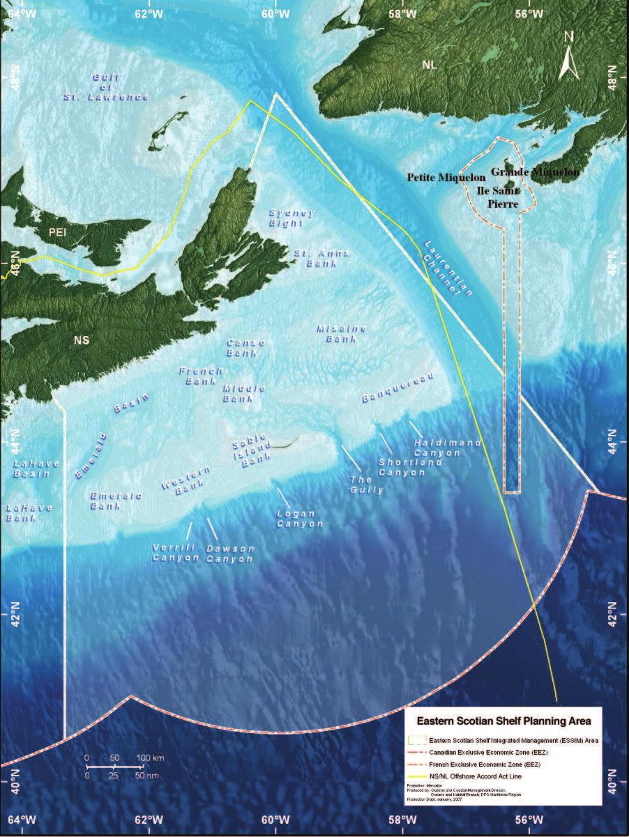
6 THE PLANNING AREA 4 The Eastern Scotian Shelf planning area encompasses some 325,000 square kilometres, an area more than six times the size of the adjacent province of Nova Scotia. The area was selected for integrated ocean management because of its important living and non-living marine resources, areas of high biological diversity and productivity, and increasing levels of use and competition for ocean space and resources. (See map on page six) The focus on the Plan is on the offshore portions of the region, essentially seaward from the Territorial Sea (12 nautical miles). The offshore was chosen as the initial focus for the Plan for several reasons, including the desire to capture the area surrounding the Gully Marine Protected Area, which lies about 200 kilometres offshore, and the need to address increasing levels of multiple human use on the shelf and along the shelf break. Recognizing that the management needs and approaches for the offshore differ in many ways from the inshore context especially in terms of jurisdictions, use patterns, ecosystem characteristics and communities of interest it was decided to first develop an offshore planning process. However, the longer term commitment to build complementary integrated management initiatives for coastal and inshore areas remains. MARINE ENVIRONMENT The Eastern Scotian Shelf is characterized by large shallow banks on the outer part of the shelf, with basins and smaller banks in the middle and inner shelf. The planning area also includes portions of the continental rise and slope, which is indented by several submarine canyons. The planning area includes the Gully, Atlantic Canada s first Marine Protected Area. The Gully is the largest marine canyon in eastern North America and contains a rich diversity of marine habitats and species, including deep-sea corals and northern bottlenose whales. Nearby Sable Island is home to wild horses, seals and birds. TOWARD THE EASTERN SCOTIAN SHELF INTEGRATED OCEAN MANAGEMENT PLAN: A TIMELINE 2004 The Gully, located centrally in the ESSIM planning area, is designated as Canada s second Marine Protected Area under the Oceans Act A Draft of the Eastern Scotian Shelf Integrated Ocean Management Plan is released at the 3rd ESSIM Forum Workshop in February. The focus of the workshop is to review and comment on the draft Plan. In the fall, the Regional Committee on Ocean Management (RCOM) and the Stakeholder Advisory Council (SAC) are formed. RCOM is the senior executive level body for federal and provincial departments


7 HUMAN USE A broad range of human activities occur on the Eastern Scotian Shelf. These activities include fisheries, oil and gas, commercial shipping, as well as marine conservation, research, tourism and government operations. 5 Many components of the Eastern Scotian Shelf ecosystem have changed as a result of human actions and natural variability. From a species perspective, some groups are proliferating, such as pelagic fishes and some benthic invertebrate species, while others have declined and are not rebuilding as quickly as expected, most notably groundfish. Changes in physical habitats, water temperature and productivity have also been observed. Some portions of the planning area experience relatively high or intensive levels of use, such as regularly fished areas, hydrocarbon production areas, and high vessel traffic areas. Other areas remain little to moderately used. In fact, the Eastern Scotian Shelf is characterized overall by relatively low-to-moderate levels and concentrations of multiple use. There are also areas of importance and significance to specific user or interest groups. This importance may be derived from traditional use, or from the specific resource, ecological or cultural characteristics of an area or feature. The value placed on access to such areas must be considered when planning for and managing multiple use. and agencies with ocean-related program activities. The SAC is broadly representative of ocean sectors, communities of interest and stakeholders The SAC completes a Final Draft Plan that is released for broader stakeholder and government discussion in July. In November, the SAC endorses the Plan. A month later, the Plan is endorsed by the RCOM The Eastern Scotian Shelf Integrated Ocean Management Plan is released as the country s first integrated management plan under the Oceans Act.
8


9 A VISION FOR THE EASTERN SCOTIAN SHELF The most important challenge facing any group or organization is the development of a common vision. In order to be acceptable, a vision must accommodate and include the individual desires, needs and aspirations of all of the people involved in the process. In the case of the Eastern Scotian Shelf, the range of interests are diverse and include commercial, Aboriginal and recreational fishing, offshore energy, commercial shipping, marine conservation, submarine cables, scientific research, monitoring and technology development, marine tourism, and numerous government authorities. In a number of cases, sectors compete with each other for use and access. One of the important achievements of the Plan is that this diverse range of stakeholders reached consensus on a common vision for the Eastern Scotian Shelf: Healthy and sustainable ecosystems, economies and communities supported by a collaborative, integrated and harmonized governance and management GUIDING PRINCIPLES The Plan is founded on a number of important principles and approaches: Integration Sustainable development Precaution Inclusion Adaptive management Collaboration Conservation Ecosystem-based management Stewardship 7
10 COLLABORATIVE PLANNING 8 The Plan has been developed through a multi-stakeholder, collaborative approach involving all interested and affected parties. The underlying premise is that a management plan developed through collaboration will be broadly accepted and used by all involved in the process. The collaborative planning model for the ESSIM Initiative includes mechanisms that allow various government departments and agencies to work together on ocean management issues. It also includes a mechanism for the various ocean sectors and interest groups to come together to discuss common issues and provide advice to government decision makers. The collaborative planning model is made up of four main structures. ESSIM FORUM The ESSIM Forum serves as a broad general assembly for all stakeholders to participate in the collaborative planning process. Members meet on a biennial basis to provide input and are also kept informed by regular e-newsletters and web-based information. STAKEHOLDER ADVISORY COUNCIL (SAC) The Stakeholder Advisory Council (SAC) shares the responsibility for leadership and guidance in meeting the vision for the ESSIM Initiative. The SAC operates on a consensus basis for the stewardship of the Plan and undertakes monitoring and evaluation functions for plan implementation. ESSIM Stakeholder Advisory Council: current membership breakdown Government of Canada 4 members Conservation Groups 3 members Government of Nova Scotia 3 members Community Groups 2 members Government of 1 member Academic & Private 2 members Newfoundland & Labrador Sector Research Offshore Petroleum Board 1 member Transportation 1 member Municipal Government 2 members Telecommunications 1 member Aboriginal Peoples 2 members Tourism 1 member Fisheries 5 members Citizens at Large 1-2 members (proposed, optional) Oil and Gas 2 members Total: 32 members The number of representatives for each sector has been developed with primary consideration given to the relative size of the sector, its complexity and economic, social, environmental and legislative links to the planning area. Nomination of citizens at large may be done by the ESSIM Planning Office in consultation with the sectors and interests.


11 The SAC membership is representative of ocean sectors, communities of interest and stakeholders, and it is balanced by sector as well as other criteria, such as group size, capacity, and commitment to the process. GOVERNMENT SECTOR STRUCTURE The government sector structure consists of the Federal-Provincial ESSIM Working Group and the Regional Committee on Ocean Management. Federal-Provincial ESSIM Working Group The Federal-Provincial ESSIM Working Group serves as an intergovernmental forum to focus on policy, management and regulatory coordination for the ESSIM Initiative. Membership consists of representatives of over 20 ocean-related federal and provincial departments, agencies and boards. Regional Committee on Ocean Management (RCOM) The Regional Committee on Ocean Management (RCOM) is the senior executive level forum for federal and provincial departments and agencies with ocean-related program activities. The RCOM provides advice and recommendations to mandated decision-making processes and relevant government departments, agencies and boards. ESSIM PLANNING OFFICE The Planning Office works in cooperation with the SAC and the government sector structure to provide shared leadership and coordination for development and implementation of the Plan. The Planning Office is housed within the Oceans and Coastal Management Division (OCMD) of Fisheries and Oceans Canada at the Bedford Institute of Oceanography in Dartmouth, Nova Scotia. 9


12 OBJECTIVES-BASED MANAGEMENT 10 Objectives-based management has been used by groups around the world to help them deal effectively with complex, wide-ranging and sometimes competing goals. Objectives-based management is an outcome oriented management system with results that are both measurable and capable of being evaluated. In an objectives-based framework, overarching goals are supported by more specific objectives for which indicators and targets are set and associated management strategies are taken and measured. Each overarching goal is expressed as an outcome statement. The objectives are what we want to have happen to support the main goals; while strategies are outlined to show the courses of action necessary to reach those objectives. Specific actions, time frames and resource requirements are then outlined in the supporting action planning and implementation processes. Marine systems are complex and dynamic. With our current understanding of the Scotian Shelf and its dynamics, it is acknowledged that there are certain limits and challenges to what can be achieved through the Plan. Similarly, it is recognized that the Plan can only have a certain amount of influence over various economic, social and governance factors, many of which are external to the planning process itself. The goals, objectives and strategies for the Plan have been developed to express what we are striving to achieve through integrated and ecosystem-based ocean management over the long term. The Plan is a living document put together by people with the best knowledge available to them. As our knowledge of the system improves, and as circumstances change, the objectives will adapt to accommodate and address these changes.
13 GOALS AND OBJECTIVES The aim of the Plan is to provide a common basis for commitment and action for sustainable use, marine conservation, and integrated ocean management. To achieve this, the Plan is organized around the three overarching goals of collaborative governance and integrated management, sustainable human use, and healthy ecosystems, as set in the box below. Objectives have been developed for each of the goals. The objectives are organized around a set of core elements to describe more specifically what we want to achieve. COLLABORATIVE GOVERNANCE AND INTEGRATED MANAGEMENT The goal of collaborative governance and integrated management essentially creates the enabling environment for achieving the goals of sustainable human use and healthy ecosystems. This goal is broken down into the two core elements of integrated management and information and knowledge. The overall intent of the integrated management element is to provide a more inclusive, collaborative and horizontal approach to the management of our ocean uses and resources. The objectives include establishing new governance structures, ensuring all relevant legal obligations are fulfilled, and promoting user and regulator compliance and accountability. The objectives under the information and knowledge element are focused on the requirements for strong research and knowledge building to support management decisions. They also stress the importance of information sharing and communication among stakeholders and decision makers. SUSTAINABLE HUMAN USE The overall intent of the sustainable human use goal is to ensure that current and future generations continue to receive benefits from and have access to the ocean and its resources. The two interconnected elements for this goal are social and cultural wellbeing and economic well-being. The main focus of the social and cultural well-being element is on sustainable communities and healthy 11 COLLABORATIVE GOVERNANCE AND INTEGRATED MANAGEMENT Effective governance structures and processes. Capacity among stakeholders. Knowledge to support integrated management. SUSTAINABLE HUMAN USE Ecologically sustainable use of ocean space and resources. Sustainable communities and economic well-being. HEALTHY ECOSYSTEMS Resilient and productive ecosystems, with diverse habitats, communities, species and populations. Strong marine environmental quality supports ecosystem functioning.


14 12 human relationships with the ocean. The objectives under this element emphasize the need for equitable opportunities and access for coastal communities to sustainable livelihoods from the ocean. This element also recognizes that sustainable human use is dependent on a safe, healthy and secure ocean area for people who derive their living from the sea, reap its recreational benefits or consume products of the sea. The economic well-being element addresses the economic benefits that are associated with and derived from ocean resources, including renewable and non-renewable resources found in the ocean, on the surface of the ocean, or on or below the ocean floor (e.g., fish, oil and gas). This element also includes the benefits provided by ocean infrastructure (e.g., submarine cables) and other ocean-related activities (e.g., cruise ships and commercial shipping). HEALTHY ECOSYSTEMS The overall intent of the goal for healthy ecosystems is to ensure that structure, function and environmental quality of the marine ecosystems associated with the Scotian Shelf are not compromised by our management and use. This goal is organized in the three interconnected themes of biodiversity, productivity and marine environmental quality, each containing a set of more specific elements and supporting objectives. The biodiversity objectives are aimed at the conservation of ecosystem components to support a diversity of communities, assemblages, species and populations. This means that no community, species or population should be lost as a result of human activities. The productivity objectives focus on achieving healthy conditions for the elements of primary and secondary productivity, trophic structure and population productivity. The overall intent is to ensure that human activity does not cause unacceptable alterations to these core drivers for ecosystem functioning. The marine environmental quality objectives are intended to safeguard the physical, chemical and habitat elements of marine ecosystems. The objectives are aimed at ensuring that the quality of the environment is capable of supporting the growth and health of marine organisms.

15 MANAGEMENT STRATEGIES The Plan sets out a series of management strategies to achieve the objectives identified for healthy ecosystems, sustainable human use, and collaborative governance and integrated management. Each strategy is intended to represent a general course of activities that will be pursued in order to reach one or more objectives. The strategies promote the use of various tools and approaches to achieve many of the objectives, such as ocean use mapping and spatial decision support, ecosystem classification and modeling, and industryled best practices and stewardship programs. The strategies often reference existing programs and initiatives that contribute to the achievement of the objectives. In some cases, the continuation or enhancement of existing programs and initiatives may be all that is required to achieve an objective, while in other cases, entirely new programs and activities will be necessary. The Plan does not provide details on the specific actions that will be pursued under each strategy or the organizations that will carry them out. Additional detail on management actions, timelines, indicators and lead organizations will be identified though the action planning process that will be used to implement the Plan. In many cases, individual sectors will develop and undertake actions to support the Plan. However, the planning processes will also be used to identify gaps and needs for collaborative action and new efforts. Two examples of the Plan already in action are highlighted in this section. Seeing the Plan in action as we do here illustrates how strategies and actions can achieve the big picture goals. 13 OCEAN USE MAPPING: A TOOL FOR DECISION SUPPORT Understanding spatial and temporal patterns of the ecosystem and human activities is essential to the implementation of integrated management. The ESSIM Planning Office is undertaking a major project to develop a decision support tool for multiple use management on the Scotian Shelf. The first phase focused on the completion of a GIS-based atlas showing the location and extent of major human activities and related management zones and practices in the region. Areas of importance for various ocean uses will be characterized and ecological information will also be incorporated in a subsequent phase. This atlas and its underlying database will form a key component of a spatial-temporal framework to assess risks associated with a range of human activities, including ecosystem impacts and sector activity interactions. The project is designed to support regional ocean planning, management and decision making, including the Eastern Scotian Shelf planning process and the Gully Marine Protected Area. As such, the development of prototype analysis will focus on priority management needs in the region. The completion of this geospatial assessment tool has been identified in the Plan as a key activity in support of multiple ocean use and marine ecosystem-based management.


16 14 PLAN IMPLEMENTATION AND EVALUATION The success of the Plan is dependent on continued support and commitment by all stakeholders. The most important way to do this is through meaningful and tangible actions. Governments can incorporate the Plan and its relevant provisions in their departmental policy, program and planning documents. In a similar fashion, stakeholders can incorporate the Plan in their sector plans, codes of conduct, or industry standards, to name but a few available tools. Because so much of the integrated management approach is dependent on government policy integration across a broad spectrum of departments, the question is often posed about what to do when a government authority cannot commit to something found in the Plan. In answer to this important and practical question, the collaborative planning process has been designed so that endorsement of the Plan by a government authority can occur with a commitment to further consideration of the issue in the future. This approach allows the Plan to move forward in the absence of full agreement on all aspects. As the Plan is implemented over time, there will be a strong need for effective and meaningful performance evaluation. Progress will be measured by outcome indicators for the various objectives, and through results achieved by the specific strategies and supporting actions. Reporting on progress will be transparent and information will be available to all parties. Although the Plan is designed to have a long term life span, it will undergo a comprehensive review every five years.


17 CORAL CONSERVATION 15 Tropical corals have long been a focus of marine biodiversity conservation efforts worldwide, but cold-water corals have gained increasing conservation attention in recent years. Their important role in the ecosystem and their sensitivity to human impacts has made them a focus of particular interest. Several fisheries closures have been established on the Scotian Shelf over the past five years to protect corals, including a closure to protect the reef-building coral Lophelia pertusa in the Laurentian Channel and a larger closure to protect a variety of corals in the Northeast Channel. While these closures are successful examples of efforts to protect specific coral aggregations on a case-by-case basis, a more comprehensive approach to coral conservation is being sought. The ESSIM Planning Office recently released a Coral Conservation Plan for the Maritimes Region, based on consultation with ocean stakeholders, scientists and government partners. The plan describes what is known about the species of corals found off Nova Scotia, identifies the key issues related to corals and managing human activities, describes existing management measures, outlines research requirements, and suggests strategies and actions for conserving areas of known and potential importance. The Coral Conservation Plan represents a more coordinated and strategic approach to conservation that will contribute to the objectives of the Eastern Scotian Shelf Integrated Ocean Management Plan.


18 MOVING FORWARD 16 What you ve read here is a very brief treatment of the Eastern Scotian Shelf Integrated Ocean Management Plan, the first of its kind in Canada. The Plan is an important milestone and achievement under the Oceans Act, but it does not signify the end of the process. The goals and objectives set out in the Plan are about long-term commitment and change. In other words, the Plan is really only the beginning. It is important to get involved in implementation and action planning, and to do your part in achieving the vision of the Plan. We encourage you to read the full text of the Plan for a more detailed understanding of the goals, objectives and strategies that are contained within it. You can find the full text of the Plan and all of the supporting documents that have been produced during its development at The ESSIM Planning Office is always interested and available to meet with organizations and individuals. If you would like to receive a copy of the Plan or discuss next steps in the planning process, please contact us at the following address: ESSIM Planning Office Oceans and Coastal Management Division Fisheries and Oceans Canada Bedford Institute of Oceanography PO Box 1006 Dartmouth, Nova Scotia B2Y 4A2 Tel: (902) Fax: (902) essim@mar.dfo-mpo.gc.ca
19
20 ESSIM Planning Office Oceans and Coastal Management Division Fisheries and Oceans Canada Bedford Institute of Oceanography PO Box 1006 Dartmouth, Nova Scotia B2Y 4A2 Tel: (902) Fax: (902)
Outline National legislative & policy context Regional history with ESSIM ESSIM Evaluation Phase Government Integration via RCCOM Regional ICOM Framew
 What MSP Implementation could change in the Maritimes Region Tim Hall, Regional Manager Oceans and Coastal Management Division Ecosystem Management Branch Fisheries and Oceans Canada Maritimes Region BIO
Designing Networks of Marine Protected Areas in DFO s Three Atlantic Bioregions
 Designing Networks of Marine Protected Areas in DFO s Three Atlantic Bioregions Presentation for Indigenous Protected Areas Workshop Max Westhead, DFO and Adrian Gerhartz-Abraham, Dalhousie March 29, 2017
Spatial Planning in Canada s Maritimes Region. Maritimes Region
 Spatial Planning in Canada s Maritimes Region Glen Herbert, Scott Coffen-Smout Smout,, and Tanya Koropatnick Oceans and Coastal Management Division Ecosystem Management Branch Fisheries and Oceans Canada
Aboriginal communities strengthen governance with location-based tools in the 21st century
 Aboriginal communities strengthen governance with location-based tools in the 21st century Today, Aboriginal communities are taking advantage of the geomatics technologies that underpin popular online
DEVELOPMENT FOR THE PEOPLE OF THE NORTH. Results achieved during
 DEVELOPMENT FOR THE PEOPLE OF THE NORTH Results achieved during Learn more about the work and the activities of the Arctic Council by visiting the Council s website and connecting on social media: www.arctic-council.org
NORTH VANCOUVER ISLAND MARINE PLAN: OVERVIEW 2015
 NORTH VANCOUVER ISLAND MARINE PLAN: OVERVIEW 2015 North Vancouver Island Marine Plan Overview Refers to: Marine Planning Partnership Initiative. 2015. North Vancouver Island Marine Plan. Copyright 2015
DFO Maritimes Region Update. Gulf of Maine Council - Coastal and Marine Spatial Planning (CMSP) Committee Web-Ex May 16, 2017
 Committee Web-Ex May 16, 2017") DFO Maritimes Region Update Gulf of Maine Council - Coastal and Marine Spatial Planning (CMSP) Committee Web-Ex May 16, 2017 1 National Oceans Priorities Marine Conservation Targets Oceans Protection Plan
DFO Maritimes Region Update Gulf of Maine Council - Coastal and Marine Spatial Planning (CMSP) Committee Web-Ex May 16, 2017 1 National Oceans Priorities Marine Conservation Targets Oceans Protection Plan
Cross-border Maritime Spatial Plan for the Black sea - Romania and Bulgaria project
 Cross-border Maritime Spatial Plan for the Black sea - Romania and Bulgaria project in Romania and Bulgaria Plan Presentation A first step in the management of the marine areas of Romania and Bulgaria
Marine Protected Area Network Planning in the Bay of Fundy and Scotian Shelf. Progress to date and next steps
 Marine Protected Area Network Planning in the Bay of Fundy and Scotian Shelf Progress to date and next steps Max(ine) Westhead, M.Sc. Section Head, Protected Areas and Conservation Planning Fisheries and
PROPOSED UNESCO FUNDY BIOSPHERE RESERVE
 OVERVIEW PROPOSED UNESCO FUNDY BIOSPHERE RESERVE NEW BRUNSWICK, CANADA NOMINATION DOCUMENT April 10, 2007 The United Nations Educational, Scientific and Cultural Organization (UNESCO) Man and the Biosphere
Marine Spatial Planning: A Tool for Implementing Ecosystem-Based Management
 Marine Spatial Planning: A Tool for Implementing Ecosystem-Based Management Steven Murawski, Ph.D., Ecosystem Goal Team Lead National Oceanic and Atmospheric Administration NOAA November 16, 2009 1 To
Marine Spatial Planning Leslie-Ann McGee Battelle Memorial Institute
 Marine Spatial Planning Leslie-Ann McGee Battelle Memorial Institute Rev061708 1 Marine Spatial Planning What is it? Why is it different? Where is it currently being employed? What is happening in the
PACIFIC ISLANDS REGIONAL OCEAN POLICY. A healthy Ocean that sustains the livelihoods and aspirations of Pacific Island communities.
 PACIFIC ISLANDS REGIONAL OCEAN POLICY VISION A healthy Ocean that sustains the livelihoods and aspirations of Pacific Island communities. THIS IS OUR OCEAN 1. The care of the ocean is the responsibility
16540/14 EE/cm 1 DG E 1A
 Council of the European Union Brussels, 5 December 2014 (OR. en) 16540/14 ENV 965 CULT 139 NOTE From: To: Subject: General Secretariat of the Council Delegations Charter of Rome on Natural and Cultural
HAMILTON DECLARATION ON COLLABORATION FOR THE CONSERVATION OF THE SARGASSO SEA
 HAMILTON DECLARATION ON COLLABORATION FOR THE CONSERVATION OF THE SARGASSO SEA Hamilton, Bermuda 11 March, 2014 WE, THE SIGNATORIES LISTED BELOW: Recognising that the islands of Bermuda are the only land
CONFERENCE STATEMENT
 Final draft CONFERENCE STATEMENT We, the elected representatives of Canada, Denmark/Greenland, the European Parliament, Finland, Iceland, Norway, Russia, Sweden and the United States of America; In collaboration
Geological Survey of Canada Lands and Minerals Sector Natural Resources Canada OneGeology, June 2018
 Geological Survey of Canada Lands and Minerals Sector Natural Resources Canada OneGeology, June 2018 Geological Survey of Canada Mission The Geological Survey of Canada provides public geoscience knowledge
Geospatial Policy Development and Institutional Arrangements *
 HIGH LEVEL FORUM ON GLOBAL GEOSPATIAL MANAGEMENT INFORMATION WORKING PAPER No. 13 First Forum Seoul, Republic of Korea, 24-26 October 2011 Geospatial Policy Development and Institutional Arrangements *
Building capacity to support decisionmaking for protection and management of marine areas
 Credit_Deep Atlantic Stepping Stones Science Team_IFE_URI_NOAA_no3 Credit: John Weller, john@lastocean.com Credit: John Weller, john@lastocean.com Credit: John Weller, john@lastocean.com Credit: Sarah
MARINE SPATIAL PLANNING & MARINE CADASTRE: CHALLENGES AND ISSUES
 MARINE SPATIAL PLANNING & MARINE CADASTRE: CHALLENGES AND ISSUES Roger Longhorn Secretary General, GSDI Association rlonghorn@gsdi.org Member, IHO Marine SDI Working Group ral@alum.mit.edu Member, UNESCO
MARINE SPATIAL PLANNING
 MARINE SPATIAL PLANNING Washington Uses Spatial Planning to Honor its Pacific Coast and Offshore Waters Past, Present and Future The Washington State Pacific Coast and offshore waters are diverse in both
Fish and Fish Habitat Follow-up Program. Scotian Basin Exploration Project
 Fish and Fish Habitat Follow-up Program Scotian Basin Exploration Project April 2018 Contents 1 Introduction... 1 2 Scope... 1 3 EIS Commitments and Predictions... 2 4 Methodology and Reporting... 2 4.1
Country Fiche Sweden Updated May 2018
 Country Fiche Sweden Updated May 2018 1. General information 2 the territorial sea (12-nm zone) 70,000 km2 the Exclusive Economic Zone 60,000 km2 the EEZ is limited to the central line between adjacent
DELIVERING ECOSYSTEM- BASED MARINE SPATIAL PLANNING IN PRACTICE
 DELIVERING ECOSYSTEM- BASED MARINE SPATIAL PLANNING IN PRACTICE A first assessment for the UK and Ireland January 08 GLOBAL WARMING IMAGES / WWF ABOUT WWF WWF is the world s leading independent conservation
Maritime Spatial Planning in the Baltic Sea Region
 Maritime Spatial Planning in the Baltic Sea Region Talis Linkaits Head of VASAB Secretariat 20 May 2015 Helsinki A cooperation of ministers of the 11 Baltic Sea Region countries responsible for spatial
Implementing the Sustainable Development Goals: The Role of Geospatial Technology and Innovation
 Fifth High Level Forum on UN Global Geospatial Information Management Implementing the Sustainable Development Goals: The Role of Geospatial Technology and Innovation 28-30 November 2017 Sheraton Maria
UN-GGIM: Strengthening Geospatial Capability
 Fifth Plenary Meeting of UN-GGIM: Europe Brussels, 6-7 June 2018 UN-GGIM: Strengthening Geospatial Capability Walking the talk to leave no one behind Greg Scott, UN-GGIM Secretariat Environmental Statistics
2007 / 2008 GeoNOVA Secretariat Annual Report
 2007 / 2008 GeoNOVA Secretariat Annual Report Prepared for: Assistant Deputy Minister and Deputy Minister of Service Nova Scotia and Municipal Relations BACKGROUND This report reflects GeoNOVA s ongoing
Policy framework The Netherlands and the Polar Regions, Summary and priorities
 Policy framework The Netherlands and the Polar Regions, 2011-2015 Summary and priorities The policy outlined in this Policy Framework for the Polar Regions (2011-2015) is part of the government s orientation
HELSINKI COMMISSION Baltic Marine Environment Protection Commission
 HELSINKI COMMISSION Baltic Marine Environment Protection Commission HELCOM RECOMMENDATION 24/10 Adopted 25 June 2003, having regard to Article 20, Paragraph 1 b) of the 1992 Helsinki Convention IMPLEMENTATION
An Environmental Profile of the Island of Jost Van Dyke, British Virgin Islands
 An Environmental Profile of the Island of Jost Van Dyke, British Virgin Islands Executive Summary including Little Jost Van Dyke, Sandy Cay, Green Cay and Sandy Spit This publication was made possible
Ministry of Health and Long-Term Care Geographic Information System (GIS) Strategy An Overview of the Strategy Implementation Plan November 2009
 Strategy An Overview of the Strategy Implementation Plan November 2009") Ministry of Health and Long-Term Care Geographic Information System (GIS) Strategy An Overview of the Strategy Implementation Plan November 2009 John Hill, Health Analytics Branch Health System Information
Ministry of Health and Long-Term Care Geographic Information System (GIS) Strategy An Overview of the Strategy Implementation Plan November 2009 John Hill, Health Analytics Branch Health System Information
National Perspectives - Portugal. Margarida Almodovar
 National Perspectives - Portugal Margarida Almodovar margarida.almodovar@mam.gov.pt from base line to the external limit of the continental shelf behind 200 miles and according to UNCLOS definitions Economic
REGIONAL OCEANS PLAN
 FISHERIES AND OCEANS CANADA MARITIMES REGION 2016 REGIONAL OCEANS PLAN SCOTIAN SHELF ATLANTIC COAST BAY OF FUNDY Progress Report 2014-2016 Fisheries and Oceans Canada Pêches et Océans Canada Implementing
IMA s ROLE IN COASTAL AND OCEAN GOVERNANCE IN TRINIDAD AND TOBAGO
 IMA s ROLE IN COASTAL AND OCEAN GOVERNANCE IN TRINIDAD AND TOBAGO Presented by Rahanna Juman, Deputy Director (Ag.) About the Institute of Marine Affairs Institute of Marine Affairs (IMA) was established,
FINDINGS OF THE ARCTIC METEOROLOGY SUMMIT
 FINDINGS OF THE ARCTIC METEOROLOGY SUMMIT 2018 WWW.FMI.FI CHAIR S SUMMARY: 1 2 3 We need to be curious to explore the known unknowns. Meteorology is an elemental part of international collaboration in
Country Fiche Latvia Updated October 2016
 Country Fiche Latvia Updated October 2016 1. General information Marine area under Latvian jurisdiction includes inland sea waters, Territorial sea (12 nautical miles from the baseline) and exclusive economic
Marine Spatial Planning (MSP): A practical approach to ecosystembased
: A practical approach to ecosystembased") Marine Spatial Planning (MSP): A practical approach to ecosystembased management Erik Olsen, Institute of Marine Research, Norway Fanny Douvere, International Oceanographic Commission Overview Why we need
Marine Spatial Planning (MSP): A practical approach to ecosystembased management Erik Olsen, Institute of Marine Research, Norway Fanny Douvere, International Oceanographic Commission Overview Why we need
Marine/Maritime Spatial Planning Andrej Abramić
 Marine/Maritime Spatial Planning Andrej Abramić EcoAqua SUMMER SCHOOL: Ecosystem approach to aquaculture 26-29th of October 2015 Research and Technology to enhance excellence in Aquaculture development
Towards coherent maritime spatial planning in the Baltic Sea Region, transnational and project perspective Talis Linkaits Head of VASAB Secretariat
 3 June 2013 Riga PartiSEApate Workshop MSP as Tool for Underwater Cultural Heritage Management in the Baltic Sea Towards coherent maritime spatial planning in the Baltic Sea Region, transnational and project
KUNMING FORUM ON UNITED NATIONS GLOBAL GEOSPATIAL INFORMATION MANAGEMENT CITIES OF THE FUTURE: SMART, RESILIENT
 KUNMING FORUM ON UNITED NATIONS GLOBAL GEOSPATIAL INFORMATION MANAGEMENT CITIES OF THE FUTURE: SMART, RESILIENT and SUSTAINABLE Yunnan Zhenzhuang Guest House, Kunming, China 10 12 May 2017 BACKGROUND CONCEPT
CONFERENCE STATEMENT
 CONFERENCE STATEMENT We, the elected representatives from Canada, Denmark/Greenland, Finland, Iceland, Norway, Russia, Sweden and the United States of America; In collaboration with the indigenous peoples
Dr. Biliana Cicin-Sain President, Global Ocean Forum 1
 Towards a Sustainable Development Goal on Oceans and Seas: Healthy, Productive and Resilient Oceans and Seas- Prosperous and Resilient Peoples and Communities Dr. Biliana Cicin-Sain President, Global Ocean
NOAA Nautical Charts and Coastal and Marine Spatial Planning. Meredith Westington Chief Geographer NOAA/NOS/Office of Coast Survey
 NOAA Nautical Charts and Coastal and Marine Spatial Planning Meredith Westington Chief Geographer NOAA/NOS/Office of Coast Survey Ocean Policy Task Force What is CMSP? A comprehensive, adaptive, integrated,
Council conclusions on Arctic issues. 2985th FOREIGN AFFAIRS Council meeting Brussels, 8 December 2009
 COU CIL OF THE EUROPEA U IO EN Council conclusions on Arctic issues 2985th FOREIGN AFFAIRS Council meeting Brussels, 8 December 2009 The Council adopted the following conclusions: The Council recalls its
Natura 2000 and spatial planning. Executive summary
 Natura 2000 and spatial planning Executive summary DISCLAIMER The information and views set out in this study are those of the author(s) and do not necessarily reflect the official opinion of the Commission.
Economic and Social Council
 United Nations Economic and Social Council Distr.: General 18 July 2016 Original: English Committee of Experts on Global Geospatial Information Management Sixth session New York, 3-5 August 2016 Item 2
Data Sources and Methods for the Protected Areas Indicators. July 2012
 Data Sources and Methods for the Protected Areas Indicators July 2012 ISBN : En4-144/11-2012E-PDF Cat. No.: 978-1-100-20994-4 Information contained in this publication may be reproduced, in part or in
Natura 2000 in the marine environment: state of implementation and next steps
 Life on the blue planet: biodiversity research and the new European marine policies EPBRS European Platform on Biodiversity Research Strategy Porto, Portugal 7-9 November 2007 Natura 2000 in the marine
REVIEW OF ALTERNATE BALLAST WATER EXCHANGE ZONES FOR VESSEL TRAFFIC TO NEWFOUNDLAND AND LABRADOR AND THE CANADIAN ARCTIC
 Canadian Science Advisory Secretariat Science Advisory Report 2010/026 REVIEW OF ALTERNATE BALLAST WATER EXCHANGE ZONES FOR VESSEL TRAFFIC TO NEWFOUNDLAND AND LABRADOR AND THE CANADIAN ARCTIC Figure 1:
Observation (EO) & Geomatics in Canada
 & Geomatics in Canada") Innovating to Increase the Impact of Earth Observation (EO) & Geomatics in Canada Natural Resources Canada February 25, 2014 Prashant Shukle, Director General Canada Centre for Mapping and Earth Observation
Innovating to Increase the Impact of Earth Observation (EO) & Geomatics in Canada Natural Resources Canada February 25, 2014 Prashant Shukle, Director General Canada Centre for Mapping and Earth Observation
Planning for the Shoreline
 Planning for the Shoreline A Summary of the roundtable discussion at Georgia Strait Alliance s second Waterfront Forum June 23, 2014 SFU Harbour Centre Vancouver, BC Planning for the Shoreline Georgia
Norway s Integrated Ocean Management (IOM) Policies and Plans - A Brief Presentation
 Policies and Plans - A Brief Presentation") OGS/- 20.08.2014. Paper based on an up-dated version of the author's presentation at the seminar "Økosystembasert tilnærming i Norge" ("Ecosystems-based Approach in Norway"), organized by the Tromsø University,
OGS/- 20.08.2014. Paper based on an up-dated version of the author's presentation at the seminar "Økosystembasert tilnærming i Norge" ("Ecosystems-based Approach in Norway"), organized by the Tromsø University,
PUBLIC HEALTH ASSOCIATION OF AUSTRALIA Strategic Plan
 PUBLIC HEALTH ASSOCIATION OF AUSTRALIA Strategic Plan March 2017 20 Napier Close Deakin ACT Australia 2600 PO Box 319 Curtin ACT Australia 2605 Table of Contents Introduction... 2 Vision for a healthy
Economic and Social Council
 United Nations Economic and Social Council Distr.: General 2 July 2012 E/C.20/2012/10/Add.1 Original: English Committee of Experts on Global Geospatial Information Management Second session New York, 13-15
PROGRAM OF THE RUSSIAN FEDERATION CHAIRMANSHIP OF THE ARCTIC COUNCIL IN
 PROGRAM OF THE RUSSIAN FEDERATION CHAIRMANSHIP OF THE ARCTIC COUNCIL IN 2004-2006 The Arctic Council is a unique forum for interaction between the governments of the Arctic States, the Permanent Participants
THE SEVILLE STRATEGY ON BIOSPHERE RESERVES
 THE SEVILLE STRATEGY ON BIOSPHERE RESERVES 1 VISION FOR BIOSPHERE RESERVES IN THE 21 ST CENTURY The international Seville Conference on Biosphere Reserves, organised by UNESCO, adopted a two-pronged approach,
Linking Global and Regional Levels in the Management of Marine Areas Beyond National Jurisdiction
 Linking Global and Regional Levels in the Management of Marine Areas Beyond National Jurisdiction South Atlantic Region Session 4: «Experiences, Priorities and Opportunities in the South Atlantic and Indian
Introduction to IMP: need and added value
 Introduction to IMP: need and added value Christophe Le Visage Consultant Stratégies Mer et Littoral 1 Summary IMP : Why? The case for integration 1 What is IMP? 2 Content, process IMP: Added Value 3 2
LA POLÍTICA MARÍTIMA INTEGRADA
 LA POLÍTICA MARÍTIMA INTEGRADA Ministerio de Agricultura, Alimentación y Medio Ambiente Juan Luís Suárez de Vivero 2 4 de abril de 2014, Madrid INTEGRATED MARINE POLICY 1. PLANES, MARCO JURÍDICO-ADMINISTRATIVO,
International Guidelines for Ecosystem-based, Marine Spatial Management
 International Guidelines for Ecosystem-based, Marine Spatial Management Charles Ehler and Fanny Douvere, Consultants Intergovernmental Oceanographic Commission and Man and the Biosphere Programme UNESCO
Country Fiche Estonia
 Country Fiche Estonia Deleted: October Updated May 2018 Deleted: 7 1. General information Size of internal waters (to the baseline) and territorial sea (12-nm zone from the baseline) approximately 25 200
FISHERIES AND OCEANS CANADA MARITIMES REGION 2014 REGIONAL OCEANS PLAN SCOTIAN SHELF ATLANTIC COAST BAY OF FUNDY. Background and Program Description
 FISHERIES AND OCEANS CANADA MARITIMES REGION 2014 REGIONAL OCEANS PLAN SCOTIAN SHELF ATLANTIC COAST BAY OF FUNDY Background and Program Description Fisheries and Oceans Canada Pêches et Océans Canada Fisheries
World Oceans Day 2010 Our oceans: opportunities and challenges
 World Oceans Day 2010 Our oceans: opportunities and challenges Roundtable discussion on the United Nations Convention on the Law of the Sea fifteen years after its entry into force HOW EFFECTIVELY IS UNCLOS
TOWARDS STRATEGIC SPATIAL PLANNING IN JAMAICA: THE NATIONAL SPATIAL PLAN
 TOWARDS STRATEGIC SPATIAL PLANNING IN JAMAICA: THE NATIONAL SPATIAL PLAN JIEP 5th Biennial Conference on the Environment: Balancing National Development and Environmental Protection June 6, 2011 Jamaica
Bengt Kjellson Chair of the Executive Committee UN-GGIM: Europe. 2 nd Joint UN-GGIM: Europe ESS Meeting 11 th March 2016, Luxembourg
 Bengt Kjellson Chair of the Executive Committee UN-GGIM: Europe 2 nd Joint UN-GGIM: Europe ESS Meeting 11 th March 2016, Luxembourg A global geospatial mandate At its 47th plenary in July 2011, ECOSOC,
SPLAN-Natura Towards an integrated spatial planning approach for Natura th January, 2017 Brussels. Commissioned by DG Environment
 SPLAN-Natura 2000 Towards an integrated spatial planning approach for Natura 2000 Commissioned by DG Environment 17 th January, 2017 Brussels V. Simeonova (Ph.D.) Drivers towards integrating Biodiversity
MODELS AND TOOLS FOR GOVERNANCE OF
 Working Papers Collection No. 1/2015 MODELS AND TOOLS FOR GOVERNANCE OF THE ADRIATIC AND IONIAN SEAS www.unimc.it/maremap NATIONAL POLITICS AND EU POLITICS: THE MARITIME SPATIAL PLANNING AND INTEGRATED
8 th Arctic Regional Hydrographic Commission Meeting September 2018, Longyearbyen, Svalbard Norway
 8 th Arctic Regional Hydrographic Commission Meeting 11-13 September 2018, Longyearbyen, Svalbard Norway Status Report of the Arctic Regional Marine Spatial Data Infrastructures Working Group (ARMSDIWG)
Evaluation of Spatial Planning as a Tool for Integrated Marine Management Status, Obstacles and Research Gaps
 Evaluation of Spatial Planning as a Tool for Integrated Marine Management Status, Obstacles and Research Gaps Baltic MSP Forum Riga 17.-18. June 2014 A. Morf & A. Grimvall: Swedish Institute for the Marine
Terms of Reference for the Comparative Environmental Review (CER) of. Options for the Mactaquac Project, Mactaquac, New Brunswick
 of. Options for the Mactaquac Project, Mactaquac, New Brunswick") Terms of Reference for the Comparative Environmental Review (CER) of Options for the Mactaquac Project, Mactaquac, New Brunswick Preamble The New Brunswick Power Corporation ( NB Power ) operates the Mactaquac
Terms of Reference for the Comparative Environmental Review (CER) of Options for the Mactaquac Project, Mactaquac, New Brunswick Preamble The New Brunswick Power Corporation ( NB Power ) operates the Mactaquac
Large Scale Mapping Policy for the Province of Nova Scotia
 Large Scale Mapping Policy for the Province of Nova Scotia December, 2005 Version 1.0 TABLE OF CONTENTS PAGE BACKGROUND...3 POLICY...5 Policy 1.0 Large Scale Mapping Program...5 Policy 2.0 Service Offering...5
Economic and Social Council
 United Nation E/C.20/2012/4/Add.1 Economic and Social Council Distr.: General 2 July 2012 Original: English Committee of Experts on Global Geospatial Information Management Second session New York, 13-15
1. Baltic SCOPE Towards coherence and cross-border solutions in Baltic Maritime Spatial Plans
 NSHC 32th Conference Explanatory Note Dublin, Ireland Item E.2 MSP 21-23 June 2016 Germany Cross border MSP for the EEZ, a case study from the Baltic Sea The Federal Maritime and Hydrographic Agency of
Key Indicators for Territorial Cohesion & Spatial Planning Stakeholder Workshop - Project Update. 13 th December 2012 San Sebastián, Basque Country
 Key Indicators for Territorial Cohesion & Spatial Planning Stakeholder Workshop - Project Update 13 th December 2012 San Sebastián, Basque Country Key Aims Explore the use of territorial data in developing
Al Ain Cultural Heritage Management Strategy 1/102
 AL AIN CULTURAL HERITAGE MANAGEMENT STRATEGY EXECUTIVE SUMMARY The cultural heritage of Al Ain is rich and varied; it consists of tangible and intangible resources and incorporates archaeological sites,
Arctic ecosystem services: TEEB Arctic Scoping study. Alexander Shestakov WWF Global Arctic Programme 3 December Arctic Biodiversity Congress
 Arctic ecosystem services: TEEB Arctic Scoping study Alexander Shestakov WWF Global Arctic Programme 3 December 20143 Arctic Biodiversity Congress Content 1. Project design 2. Approach 3. Challenges and
KENYA NATIONAL BUREAU OF STATISTICS Workshop on
 KENYA NATIONAL BUREAU OF STATISTICS Workshop on Capacity Building in Environment Statistics: the Framework for the Development of Environment Statistics (FDES 2013) Coordination with Sector Ministries
TOWARDS CLIMATE-RESILIENT COASTAL MANAGEMENT: OPPORTUNITIES FOR IMPROVED ICZM IN BELIZE
 TOWARDS CLIMATE-RESILIENT COASTAL MANAGEMENT: OPPORTUNITIES FOR IMPROVED ICZM IN BELIZE CHANTALLE SAMUELS Coastal Zone Management Authority and Institute The Caribbean Community Climate Change Centre VULNERABILITY
The National Spatial Strategy
 Purpose of this Consultation Paper This paper seeks the views of a wide range of bodies, interests and members of the public on the issues which the National Spatial Strategy should address. These views
Seabed knowledge In support of UN SDGs
 Seabed knowledge In support of UN SDGs Evert Flier Fiskerifaglig forum 2. november 2017 Hydrography & small scale fishing Hydrography in Transition Serving the Maritime Community Hydrography in Transition
Spatially Enabled Society
 International Seminar on Land Administration Trends and Issues in Asia and the Pacific Region Spatially Enabled Society Abbas Rajabifard Vice Chair PCGIAP-WG3 Vice-President (President Elect), GSDI Association
Management Planning & Implementation of Communication Measures for Terrestrial Natura 2000 Sites in the Maltese Islands Epsilon-Adi Consortium
 Management Planning & Implementation of Communication Measures for Terrestrial Natura 2000 Sites in the Maltese Islands Epsilon-Adi Consortium Briefing Meetings, February 2013 CT3101/2011, MEPA, Malta
Tourism. April State Planning Policy state interest guideline. Department of Infrastructure, Local Government and Planning
 Department of Infrastructure, Local Government and Planning State Planning Policy state interest guideline Tourism April 2016 Great state. Great opportunity. Preface Using this state interest guideline
Initial Borehole Drilling and Testing in Central Huron,
 JULY 2016 PRELIMINARY ASSESSMENT OF POTENTIAL SUITABILITY Initial Borehole Drilling and Testing in Central Huron, Huron-Kinloss and South Bruce DRAFT FOR DISCUSSION WITH COMMUNITIES In 2012, at the request
What s the problem? A Modern Odyssey in Search of Relevance. The search for relevance. Some current drivers for new services. Some Major Applications
 A Modern Odyssey in Search of Relevance FIG Working Week, Athens, 24 May 2004 Paul Kelly ANZLIC Executive Director The search for relevance 1. New expectations for spatial services 2. Are we ready to meet
Introduction: The Gulf of Mexico Alliance. The Gulf GAME project MERMAid and PHINS Results & Conclusions What s next? Examples
 AAG Las Vegas March 25, 2009 Introduction: Ocean governance and Ecosystem-Based Management The Gulf of Mexico Alliance Habitat Identification and Characterization The Gulf GAME project MERMAid and PHINS
Country Fiche Lithuania
 Country Fiche Lithuania Updated June 2018 1. General information The Lithuanian maritime space is delimited by the Decree of the Government of the Republic of Lithuania of 6 December, 2004, No. 1597 and
The importance of international university and project cooperation in science
 The importance of international university and project cooperation in science The Role of Science in Arctic Social and Business Development Arctic Frontiers Science January 25, 2017 Dr. Marina Kalinina
MARINE STUDIES (MARINE SPATIAL PLANNING & MANAGEMENT) MASTER S DEGREE
 MASTER S DEGREE") MARINE STUDIES (MARINE SPATIAL PLANNING & MANAGEMENT) MASTER S DEGREE Influence, lead and provide decision making support for the management and planning of coastal and marine spaces. PROGRAM DESCRIPTION
MARINE STUDIES (MARINE SPATIAL PLANNING & MANAGEMENT) MASTER S DEGREE Influence, lead and provide decision making support for the management and planning of coastal and marine spaces. PROGRAM DESCRIPTION
Baltic Sea Region cooperation in Maritime Spatial Planning - HELCOM/VASAB
 Baltic Sea Region cooperation in Maritime Spatial Planning - HELCOM/VASAB Sten Jerdenius Swedish Ministry of the Environment HELCOM/VASAB MSP Group Baltic Sea Region subregional workshop Espoo 31 March
EXECUTIVE SUMMARY A SUBMISSION OF DATA AND INFORMATION ON THE OUTER LIMITS OF THE CONTINENTAL SHELF OF THE REPUBLIC OF NIGERIA PURSUANT TO
 EXECUTIVE SUMMARY A SUBMISSION OF DATA AND INFORMATION ON THE OUTER LIMITS OF THE CONTINENTAL SHELF OF THE REPUBLIC OF NIGERIA PURSUANT TO PART VI OF AND ANNEX II TO THE UNITED NATIONS CONVENTION ON THE
MARINE STUDIES (MARINE SPATIAL PLANNING & MANAGEMENT) MASTER S DEGREE
 MASTER S DEGREE") MARINE STUDIES (MARINE SPATIAL PLANNING & MANAGEMENT) MASTER S DEGREE Influence, lead and provide decision making support for the management and planning of coastal and marine spaces. PROGRAM DESCRIPTION
MARINE STUDIES (MARINE SPATIAL PLANNING & MANAGEMENT) MASTER S DEGREE Influence, lead and provide decision making support for the management and planning of coastal and marine spaces. PROGRAM DESCRIPTION
DRAFT PROGRAM Registration of participants, welcome coffee, exhibition tour
 DRAFT PROGRAM 20 Feb 2018 09.00-10.00 Registration of participants, welcome coffee, exhibition tour 10.00 12.00 ROUND TABLE: INTERNATIONAL COOPERATION IN THE ARCTIC PROJECTS: CHALLENGES AND OPPORTUNITIES
CHAPTER 4 HIGH LEVEL SPATIAL DEVELOPMENT FRAMEWORK (SDF) Page 95
 Page 95") CHAPTER 4 HIGH LEVEL SPATIAL DEVELOPMENT FRAMEWORK (SDF) Page 95 CHAPTER 4 HIGH LEVEL SPATIAL DEVELOPMENT FRAMEWORK 4.1 INTRODUCTION This chapter provides a high level overview of George Municipality s
CHAPTER 4 HIGH LEVEL SPATIAL DEVELOPMENT FRAMEWORK (SDF) Page 95 CHAPTER 4 HIGH LEVEL SPATIAL DEVELOPMENT FRAMEWORK 4.1 INTRODUCTION This chapter provides a high level overview of George Municipality s
The Arctic Landscape Conservation Cooperative Conservation Goals
 The Arctic Landscape Conservation Cooperative Conservation Goals Adopted by the Arctic LCC Steering Committee, 24 August 2010 Background : Landscape Conservation Cooperatives and Climate Science Centers
Coastal Guide ICZM Information System
 Coastal Guide ICZM Information System 1. Key data Project title: Implementing alternative strategies in Irish beach and dune management: involvement in sustainable coastal development Country: Ireland
Mediteranean sea issues in the view of ESPON ESaTDOR project and Marine Spatial Planning in Slovenia
 DIREKTORAT ZA PROSTOR, GRADITEV IN STANOVANJA Mediteranean sea issues in the view of ESPON ESaTDOR project and Marine Spatial Planning in Slovenia BlueMed meeting of stakeholders on a micro-regional level
Dorset MSP Evidence Base 18 th February Ness Smith C-SCOPE Project Officer
 Dorset MSP Evidence Base 18 th February 2011 Ness Smith C-SCOPE Project Officer Sectoral Topic Papers MMA Description document gives an overview of the area, it s physical and human influences 20 Topic
Opening their Shells Getting commercial clammers involved in marine spatial planning
 Opening their Shells Getting commercial clammers involved in marine spatial planning Ed Lewandowski Coastal Communities Development Specialist University of Delaware/Delaware Sea Grant Highlights Background