(fc) BPC Policy No , IIM7fyilK Office of the District Clerk TRANSITION ZONE POLICY
|
|
|
- Britton Perry
- 5 years ago
- Views:
Transcription
1 <^o (fc) San Diego Unified Port District Document M" NO.. Filed,\»,»JLX»M. T*V.V^I., IIM7fyilK Office of the District Clerk BPC Policy No. 725 SUBJECT: TRANSITION ZONE POLICY PURPOSE: It is the mission of the San Diego Unified Port District in accordance with the Port Act and Coastal Act to sustain regional nnaritime capacity balanced with environmental stewardship of the tidelands. The purpose of this policy is to protect maritime industrial lands and provide a transition to adjoining residential areas by establishing general guidelines to encourage the creation of transition zones between industrial lands and residential neighborhoods. POLICY STATEMENT: In recognition of the need to protect maritime and maritime related uses and preserve thousands of jobs provided by businesses in the waterfront industrial zones, a balance needs to be established between the needs of these industrial businesses and historic residential areas along the waterfront. It is imperative that conflicts from incompatible land uses be minimized. A Transition Zone would provide the needed balance while promoting the goals and objectives of adjacent community planning activities. To this end, the District is committed to work with the City of San Diego, the City of National City and community stakeholders to develop long term planning and land use guidelines and/or community specific plans that create Transition Zones between the District's industrial properties and residential neighborhoods. The District will work with appropriate member cities to incorporate Transition Zone land use zoning and appropriate principles contained in the attached Working Waterfront Group "Concept for Transition Zone and Distribution Zone Policy" into member cities' general and community plans. The District will also work with State and Federal legislators and other agencies as appropriate including but not limited to the Coastal Commission, Air Pollution Control District, San Diego Association of Governments, and California Air Resources Board to assist in implementing a transition zone. The District may also acquire property to support maritime industrial uses or easements to preclude development of incompatible land uses within desired Transition Zone areas as it deems appropriate with or without public private partnerships. RESOLUTION NUMBER AND DATE: , dated June 10, 2008 Page 1 of 1
2 WWG Transition Zone Concept Policy rev 12 Working Waterfront Group Concept for Transition Zone and Distribution Zone Policy Under the Port Act, the mission of the San Diego Unified Port District includes the sustainment of regional maritime capacity and mandated service as the environmental steward of the tidelands. Today, we have the opportunity to effectively integrate our long term planning and land use objectives with the goals developed by the adjacent neighborhood community groups and residents. The Residents and Community Stakeholders adjacent to our Port industrial properties deserve our utmost consideration as we formulate long-term strategies for the preservation of our waterfront jobs base and maritime economic engine. With environmentally sensitive planning, residential neighborhoods, green spaces and transportation corridors can be created and enhanced to achieve quality of life improvements for those that live and work in our tidelands community. Further, the opportunity exists to create gracefiil transitions between historic residential areas and the waterfront industrial zones that provide training and sustaining jobs to 42,000 families within the region. In recognition of the need to preserve the thousands of jobs provided by those businesses in the waterfront industrial zones, we must achieve a balance between the needs of business, residential and recreational users of the waterfront. It is imperative that we prevent, as much as possible, conflicts that might result from incompatible land uses. A fransition zone would provide the needed balance while promoting the goals and objectives of adjacent community planning activities. To accomplish these objectives, the Unified Port of San Diego and the cities of National City and San Diego should establish fransition zones between indusfrial land and residential neighborhoods. A properly planned transition zone is critical to the sustained growth and health of all the constituencies that make up the working waterfront. In furtherance of these objectives, the Unified Port of San Diego and the City of National City should also establish a distribution zone to address the area commonly known as the National Disfribution Center. The primary purpose in developing this long-term sfrategy is to create the balance necessary to protect the neighboring residential areas from the impacts of industrial uses. Striking this balance benefits the working waterfront by providing greater certainty over the future uses, and benefits the residences by providing greater protection to their quality of life. The development of transition zones for various areas within the cities of National City and San Diego will individually recognize the particular factors relevant to each city. All parties recognize the unique considerations applicable to the City of National City, and will account for these considerations in developing that particular fransition zone and disfribution zone. Accordingly, the parties acknowledge the importance of preserving residential neighborhoods by preventing indusfrial creep, allowing the continuance of existing businesses that benefit the City of National City, enhancing economic opportunity and revenue generation which includes the opportunity for large-scale, economically beneficial businesses to establish themselves within the fransition zone area of the City of National City, and, most importantly, enhancing the quality of life for residents of the City of National City by providing greater resident and visitor serving areas along or near the bay. These factors will drive the formation of both the transition zone area and disfribution zone area for the City of National City ;?

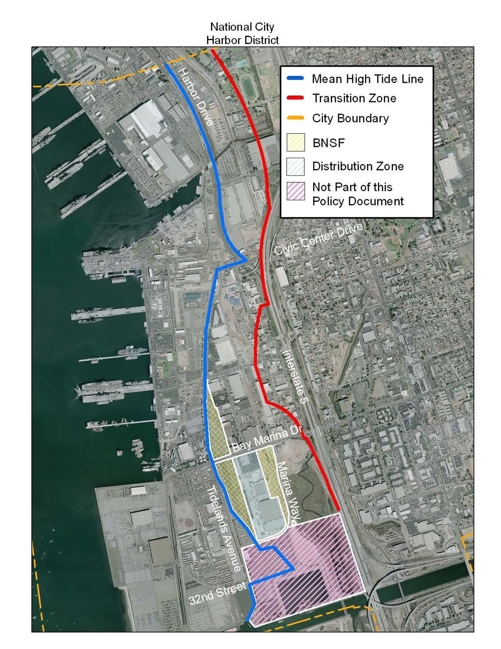
3 WWG Transition Zone Concept Policy rev 12 Definition of Transition Zone The Working Waterfront Group proposes that the Port, the City of San Diego, the City of National City and community stakeholders develop land use guidelines and community or specific plans that create fransition zones from the Port's indusfrial properties to the bordering residential neighborhoods. The specific area under consideration should include those lands from the northern boundary of the Tenth Avenue Marine Terminal south to the Sweetwater Channel, bounded on the west by the Port tidelands, extending east from the existing tidelands to the adjacent residential neighborhoods. The fransition zone is defined in maps identified as Exhibits A and B, attached to this policy document. The width of the Transition Zone shall vary to accommodate community plans, city development plans, existing structures, and zoning, forming an irregular, tailored, eastern boundary. The fransition zone should be a sequence of graduated land uses that serve to insulate and protect the integrity and environmental health of residential areas and concurrently preserve the maritime indusfrial jobs cluster. Typically this could be accomplished by a "transition zone" comprised of uses including but not sfrictly limited to, office space and greenbelt area adjacent to residential areas, bordering sfreets, fransit corridors and boulevards, parking and high-quality maritime adminisfrative office facilities. In regard to the City of National City, the factors identified in the above section will drive the uses in the fransition zone. Use of those factors will achieve the objectives of the Working Waterfront Group, protect National City residents, and enhance the economic sustainability and quality of life for National City. The fransition zone areas are delineated on the maps attached as Exhibits A (San Diego) and B (National City). These maps delineate the intended boundaries of the fransition zones and shall not be affected by land purchases by the Port within these zones. Definition of Disfribution Zone The Working Waterfront Group proposes that the Port, the City of National City and community stakeholders develop land use guidelines and land use plans that create a disfribution zone for that property commonly known as the National Disfribution Center. The specific area under consideration should include the following uses, which sfrive to balance the needs of the Working Waterfront Group, the Port, the City of National City, and National City residents: tourist and visitor serving, retail, commercial, recreational, maritime industrial staging, intermodal fransfer, warehousing, and cargo assembly, The disfribution zone area is delineated on the map attached as Exhibit B (National City). This map delineates the intended boundaries of the disfribution zone. Key Principles A fransition zone policy should adhere to the following key principles: Transition zones should provide mandated separation between indusfrial and residential land uses, safeguarding the environmental health of the regional neighborhoods and residents. Transition zones should protect and enhance the existing and prospective operations of the businesses governed by City plans. Community Group plans, and the Port Master Plan to include visitor serving, commercial, retail, indusfrial, working-waterfront, and maritimerelated, job-producing indusfries. Transition zones should only permit uses that do not pose a health risk to sensitive receptor land uses adjacent to or in the near proximity
4 WWG Transition Zone Concept Policy rev 12 Transition zones should incentivize measures that reduce health risks, noise, fraffic, and nonrenewable energy consumption. Transition zone development in San Diego should be limited to the following uses: parking, office buildings and greenbelt areas. The Transition Zone areas of National City may also include existing indusfrial areas, existing businesses, and other appropriate land use designations including retail/commercial businesses, recreational areas and visitor serving business uses designated by the City of National City. Consistent with the above principles, transition zones should make the highest and best use of land. A disfribution zone policy should adhere to the following key principles: The disfribution zone area should include the following uses: tourist and visitor serving, retail, commercial, recreational, maritime indusfrial staging, intermodal transfer, warehousing, and cargo assembly. The disfribution zone should only permit uses that do not pose a health risk to sensitive receptor land uses adjacent to or in the near proximity. Areas of Engagement The Working Waterfront Group's primary sfrategy is to work with Port cities to establish zoning regulations and planning policies that incorporate the stated transition zone and distribution zone principles. While this document is not a land use planning document, the Working Waterfront Group does seek to encourage the adoption of land use policies and plans consistent with this document. In addition, the Working Waterfront Group's proposed policy is limited to those areas specifically discussed in this document, and does not propose to affect or modify those areas outside of the transition zone or disfribution zone. Specifically, the WWG will participate in the following decision making bodies and processes: Request that the Board of Port Commissioners adopt the concept stated in this white paper. Request that language be added to the San Diego General Plan Update to institutionalize the principles outlined above. Request that community or specific plan updates for neighborhoods near the working waterfront reflect these principles. Request that the Air Pollution Confrol Disfrict consider these principles in its decision making process. Request that the California Air Resources Board consider these principles in its decision making process. Meet with city council members from Port member cities to brief them on the fransition zone policy. The Port is encouraged to secure parcels within the desired transition zones with the concurrence of the affected cities and apply the standards inherent to the Port's Charter, thereby allowing not only sustained maritime use on existing Port lands but promoting development that will constitute environmentally compatible, non-residential land uses from the industrial zone to the eastern boundary of the fransition zone. The San Diego Unified Port Disfrict shall encourage public / private partnerships in order to secure and develop these parcels ^


5 Downtown 5 Working Waterfront 1,000 Foot Buffer BNSF Residential/Mixed Use Use 5 US Navy
6
7 UJ Re Adoption of BPC Policy 725, ] Transition Zone Policy ] RESOLUTION BE IT RESOLVED by the Board of Port Commissioners of the San Diego Unified Port District, as follows: That Board of Port Commissioners Policy No. 725, Transition Zone Policy, a copy of which shall be placed on file in the office of the District Clerk, is hereby adopted. ADOPTED this loth day of JHIlf, sw 6/10/08
Exhibit IV-1: Initiation of Zoning Map Amendments Case Report HEARING DATE: MAY 3, 2012
 Exhibit IV-1: Initiation of Zoning Map Amendments Case Report HEARING DATE: MAY, 01 Case No.: 00.0MTZU Transit Center District Plan Amendments to Zoning Map Staff Contact: Joshua Switzky - (1) -1 joshua.switzky@sfgov.org
City of Chino Hills General Plan Update 13GPA02 Scoping Meeting. June 4, 2013
 13GPA02 Scoping Meeting June 4, 2013 Every California city must adopt a comprehensive, long-term general plan. The General Plan is the City s constitution or blueprint for its long-range physical development.
Application #: TEXT
 TOWN OF FORT MYERS BEACH 2008 PROPOSED COMPREHENSIVE PLAN AMENDMENTS Application #: 2008-13-TEXT Description: Modify the Coastal Management and Future Land Use Elements to reflect the state s new definition
TREASURE COAST REGIONAL PLANNING COUNCIL M E M O R A N D U M. To: Council Members AGENDA ITEM 4B10
 TREASURE COAST REGIONAL PLANNING COUNCIL M E M O R A N D U M To: Council Members AGENDA ITEM 4B10 From: Date: Subject: Staff December 14, 2018 Council Meeting Local Government Comprehensive Plan Review
Application for Geotourism Charter
 Application for Geotourism Charter Thank you for the interest in geotourism as a long-term strategy to foster wisely managed tourism and enlightened destination stewardship. National Geographic s Center
TOWARDS CLIMATE-RESILIENT COASTAL MANAGEMENT: OPPORTUNITIES FOR IMPROVED ICZM IN BELIZE
 TOWARDS CLIMATE-RESILIENT COASTAL MANAGEMENT: OPPORTUNITIES FOR IMPROVED ICZM IN BELIZE CHANTALLE SAMUELS Coastal Zone Management Authority and Institute The Caribbean Community Climate Change Centre VULNERABILITY
 3 4 5 6 7 8 9 10 11 12 13 14 15 16 17 REDCLIFF MUNICIPAL PLANNING COMMISSION FOR COMMENT/DISCUSSION DATE: TOPIC: April 27 th, 2018 Bylaw 1860/2018, proposed amendments to the Land Use Bylaw regarding cannabis
APPENDIX I - AREA PLANS
 ROUTE 37 WEST LAND USE PLAN ROUTE 37 WEST LAND USE PLAN Recent land use decisions and development trends have drawn attention to the land within the Route 37 western by-pass area between Route 50 and
CORPORATION OF THE CITY OF COURTENAY COUNCIL MEETING AGENDA
 CORPORATION OF THE CITY OF COURTENAY COUNCIL MEETING AGENDA DATE: Monday, January 14, 2013 PLACE: City Hall Council Chambers TIME: 4:00 p.m. 1.00 ADOPTION OF MINUTES 1. Adopt January 7, 2013 Regular Council
Economic Activity Economic A ctivity
 5 Economic Economic Activity Activity ECONOMIC ACTIVITY 5.1 EMPLOYMENT... 5-7 5.1.1 OBJECTIVE... 5-7 5.1.2 POLICIES... 5-7 5.2 PROTECTING THE AREA OF EMPLOYMENT... 5-9 5.2.1 OBJECTIVE... 5-9 5.2.2 POLICIES...
Local Area Key Issues Paper No. 13: Southern Hinterland townships growth opportunities
 Draft Sunshine Coast Planning Scheme Review of Submissions Local Area Key Issues Paper No. 13: Southern Hinterland townships growth opportunities Key Issue: Growth opportunities for Southern Hinterland
Study Overview. the nassau hub study. The Nassau Hub
 Livable Communities through Sustainable Transportation the nassau hub study AlternativeS analysis / environmental impact statement The Nassau Hub Study Overview Nassau County has initiated the preparation
Date: June 19, 2013 Meeting Date: July 5, Consideration of the City of Vancouver s Regional Context Statement
 Section E 1.5 To: From: Regional Planning and Agriculture Committee Lee-Ann Garnett, Senior Regional Planner Planning, Policy and Environment Department Date: June 19, 2013 Meeting Date: July 5, 2013 Subject:
An online data and consulting resource of THE UNIVERSITY OF TOLEDO THE JACK FORD URBAN AFFAIRS CENTER
 An online data and consulting resource of THE JACK FORD URBAN AFFAIRS CENTER THE CENTER FOR GEOGRAPHIC INFORMATION SCIENCE AND APPLIED GEOGRAPHICS DEPARTMENT OF GEOGRAPHY AND PLANNING THE UNIVERSITY OF
Proposed Scope of Work Village of Farmingdale Downtown Farmingdale BOA Step 2 BOA Nomination Study / Draft Generic Environmental Impact Statement
 Proposed Scope of Work Village of Farmingdale Downtown Farmingdale BOA Step 2 BOA Nomination Study / Draft Generic Environmental Impact Statement The scope of work that follows incorporates and covers
CERTIFIED RESOLUTION. introduction: and dated May 29, 2017, as attached, as appropriate
 15322 Buena Vista Avenue, White Rock BC, Canada V4B 1Y6 www.whiterockcity.ca City of White Rock P: 604.541.22121 F: 604.541.9348 /2tC% City Clerk s Office IT E ROC K June 13,2017 Stephanie Lam, Deputy
Declaration Population and culture
 Declaration Population and culture The ministers of the parties to the Alpine Convention regard the socio-economic and socio-cultural aspects mentioned in Article 2, Paragraph 2, Item a., as being central
THE SEVILLE STRATEGY ON BIOSPHERE RESERVES
 THE SEVILLE STRATEGY ON BIOSPHERE RESERVES 1 VISION FOR BIOSPHERE RESERVES IN THE 21 ST CENTURY The international Seville Conference on Biosphere Reserves, organised by UNESCO, adopted a two-pronged approach,
Mapping Maine s Working Waterfront: for Our Heritage and Economy
 Mapping Maine s Working Waterfront: for Our Heritage and Economy Abstract Mapping Maine s Working Waterfronts is a collaborative project led by the Island Institute that inventories the state s current
National Perspectives - Portugal. Margarida Almodovar
 National Perspectives - Portugal Margarida Almodovar margarida.almodovar@mam.gov.pt from base line to the external limit of the continental shelf behind 200 miles and according to UNCLOS definitions Economic
Committee Meeting November 6, 2018
 Committee Meeting November 6, 2018 Agenda Where we are in the process Land Use Plan Transportation Element Housing & Neighborhoods Elements Next Steps Schedule November 6: Plan Elements December: Plan
Outline National legislative & policy context Regional history with ESSIM ESSIM Evaluation Phase Government Integration via RCCOM Regional ICOM Framew
 What MSP Implementation could change in the Maritimes Region Tim Hall, Regional Manager Oceans and Coastal Management Division Ecosystem Management Branch Fisheries and Oceans Canada Maritimes Region BIO
CLAREMONT MASTER PLAN 2017: LAND USE COMMUNITY INPUT
 Planning and Development Department 14 North Street Claremont, New Hampshire 03743 Ph: (603) 542-7008 Fax: (603) 542-7033 Email: cityplanner@claremontnh.com www.claremontnh.com CLAREMONT MASTER PLAN 2017:
NATURE AND EXTENT OF PROPOSED DEVELOPMENT. Amount of Development Development Zones Distribution of Density Policies
 NATURE AND EXTENT OF PROPOSED DEVELOPMENT Amount of Development Development Zones Distribution of Density Policies DRAFT POOLBEG PLANNING SCHEME Amount of Development 78 4.1 The rationale for the overall
Section 2. Indiana Geographic Information Council: Strategic Plan
 Section 2. Indiana Geographic Information Council: Strategic Plan Introduction A geographic information system (GIS) is an automated tool that allows the collection, modification, storage, analysis, and
Aquaculture Spatial Planning: The case of Greece
 Aquaculture Spatial Planning: The case of Greece Nikos Anagnopoulos Panhellenic Association for Small-Medium sized Aquaculture Enterprises Panhellenic Association for Small-Medium sized Aquaculture Enterprises
Statutory framework of the world network of biosphere reserves UNESCO General Conference 1996
 Statutory framework of the world network of biosphere reserves UNESCO General Conference 1996 Keywords: conservation, protected areas, biosphere reserves, policies, strategies. For the Mountain Forum's
Marine Spatial Planning: A Tool for Implementing Ecosystem-Based Management
 Marine Spatial Planning: A Tool for Implementing Ecosystem-Based Management Steven Murawski, Ph.D., Ecosystem Goal Team Lead National Oceanic and Atmospheric Administration NOAA November 16, 2009 1 To
Dark Sky Initiative Draft Terms of Reference
 Dark Sky Initiative Draft Terms of Reference July 2008 Table of Contents 1.0 Introduction 2 2.0 Initiative intent 2-3 3.0 Initiative goals 3 4.0 Legislation 3 5.0 Municipal Development Plan 3 6.0 Land
Regional stakeholders strategy of Donegal County Council
 Regional stakeholders strategy of Donegal County Council Table of contents The template comprised five steps in the creation of this communication strategy: 1 Starting point. Communication objectives...
Aboriginal communities strengthen governance with location-based tools in the 21st century
 Aboriginal communities strengthen governance with location-based tools in the 21st century Today, Aboriginal communities are taking advantage of the geomatics technologies that underpin popular online
Joint Planning Advisory Council July 19, 2011
 Joint Planning Advisory Council July 19, 2011 Global Cities Program Objectives Helping advance strategic thinking in a variety of critical areas. Facilitating informed decisionmaking on the part of public
What s next for the Port Waterfront?
 What s next for the Port Waterfront? WATERFRONT LAND USE PLAN UPDATE The Port of San Francisco s Waterfront Land Use Plan ( Waterfront Plan ) guides land use and development on the Port s 7 1/2 mile public
King City URA 6D Concept Plan
 King City URA 6D Concept Plan King City s Evolution Among the fastest growing cities 2000 Census 1,949 2010 Census 3,111 60% increase 2016 Census estimate 3,817 23% increase Average annual rate 4.3% Surpassing
2018/1 The integration of statistical and geospatial information. The Regional Committee of UN-GGIM: Americas:
 The following are the conclusions and recommendations of the Regional Committee of the United Nations on Global Geospatial Information Management for the Americas, during its Fifth Session, Thursday 8
Neighborhood Locations and Amenities
 University of Maryland School of Architecture, Planning and Preservation Fall, 2014 Neighborhood Locations and Amenities Authors: Cole Greene Jacob Johnson Maha Tariq Under the Supervision of: Dr. Chao
HELSINKI COMMISSION Baltic Marine Environment Protection Commission
 HELSINKI COMMISSION Baltic Marine Environment Protection Commission HELCOM RECOMMENDATION 24/10 Adopted 25 June 2003, having regard to Article 20, Paragraph 1 b) of the 1992 Helsinki Convention IMPLEMENTATION
Tourism. April State Planning Policy state interest guideline. Department of Infrastructure, Local Government and Planning
 Department of Infrastructure, Local Government and Planning State Planning Policy state interest guideline Tourism April 2016 Great state. Great opportunity. Preface Using this state interest guideline
Safety Guidelines for the Chemistry Professional: Understanding Your Role and Responsibilities
 Safety Guidelines for the Chemistry Professional: Understanding Your Role and Responsibilities Kenneth P. Fivizzani Committee on Chemical Safety/ Division of Chemical Health & Safety August 22, 2017 Introduction
Statutory Framework of Biosphere Reserves. The Statutory Framework of the World Network of Biosphere Reserves
 Page 1 of 5 The Statutory Framework of the World Network of Biosphere Reserves Introduction Article 1 - Definition Article 2 - World Network of Biosphere Reserves Article 3 - Functions Article 4 - Criteria
Tackling urban sprawl: towards a compact model of cities? David Ludlow University of the West of England (UWE) 19 June 2014
 19 June 2014") Tackling urban sprawl: towards a compact model of cities? David Ludlow University of the West of England (UWE) 19 June 2014 Impacts on Natural & Protected Areas why sprawl matters? Sprawl creates environmental,
Tackling urban sprawl: towards a compact model of cities? David Ludlow University of the West of England (UWE) 19 June 2014 Impacts on Natural & Protected Areas why sprawl matters? Sprawl creates environmental,
The role of community in urban regeneration: mixed use areas approach in USA
 The role of community in urban regeneration: mixed use areas approach in USA Outline 1. Thesis 2. Main topics 3. Urban regeneration and community 4. Community involvement methods 5. Policies: EU vs USA
GIS Geographical Information Systems. GIS Management
 GIS Geographical Information Systems GIS Management Difficulties on establishing a GIS Funding GIS Determining Project Standards Data Gathering Map Development Recruiting GIS Professionals Educating Staff
Summary Description Municipality of Anchorage. Anchorage Coastal Resource Atlas Project
 Summary Description Municipality of Anchorage Anchorage Coastal Resource Atlas Project By: Thede Tobish, MOA Planner; and Charlie Barnwell, MOA GIS Manager Introduction Local governments often struggle
BACKGROUND INFORMATION DOCUMENT
 Strategic Environmental Assessment of the SKA Phase 1 in South Africa BACKGROUND INFORMATION DOCUMENT www.skaphase1.csir.co.za SKAPhase1@csir.co.za Introduction The MeerKAT and SKA projects are part of
Requirements for a Dark Skies Designation RLEP
 Requirements for a Dark Skies Designation RLEP 2017 Why Consider a Dark Skies Designation? Demonstrates a public commitment to preserving the quality of night skies Is a valuable credential for promoting
Mineral Resources
 Sacramento Local Agency Formation Commission Mineral Resources 3.11 - Mineral Resources 3.11.1 - Introduction This section describes and evaluates potential environmental impacts to mineral resources resulting
Marine Transportation and Ocean Use
 Marine Transportation and Ocean Use Data Needs for Multi-Disciplinary Long-Term Planning 4 th Biennial TRB-CMTS Research and Development Conference Matt Campo Rutgers University 6/22/2016 Overview What
Draft Model Memorandum of Understanding to promote voluntary cooperation between Government and Chemical Industry to enhance Precursors Chemicals
 Draft Model Memorandum of Understanding to promote voluntary cooperation between Government and Chemical Industry to enhance Precursors Chemicals Control 1 Introduction There has been growing recognition
Derogation Criteria for the Requirements for Generators Network Code
 Derogation Criteria for the Requirements for Generators Network Code Decision Paper Reference: CER/17/084 Date Published: 13/04/2017 Closing Date: 0 Executive Summary Commission Regulation (EU) 2016/631
Urbanization and Sustainable Development of Cities: A Ready Engine to Promote Economic Growth and Cooperation
 Urbanization and Sustainable Development of Cities: A Ready Engine to Promote Economic Growth and Cooperation Wan Portia Hamzah Institute of Strategic and International Studies (ISIS) Malaysia 10 September
PROGRAM OF THE RUSSIAN FEDERATION CHAIRMANSHIP OF THE ARCTIC COUNCIL IN
 PROGRAM OF THE RUSSIAN FEDERATION CHAIRMANSHIP OF THE ARCTIC COUNCIL IN 2004-2006 The Arctic Council is a unique forum for interaction between the governments of the Arctic States, the Permanent Participants
Population Trends Along the Coastal United States:
 Coastal Trends Report Series Population Trends Along the Coastal United States: 1980-2008 U.S. Department of Commerce National Oceanic and Atmospheric Administration National Ocean Service Assessing the
STAFF REPORT ACTION REQUIRED
 STAFF REPORT ACTION REQUIRED Appeal by Fast Signs of the Decision of the Chief Building Official for One Variance Respecting a Proposed First Party Wall Sign 10-21 Four Seasons Place Date: January 18,
Pan American Institute of Geography and History. 12th MACHC 5-9 December 2011
 Pan American Institute of Geography and History 12th MACHC 5-9 December 2011 1 PAIGH Mission and Objectives To encourage, coordinate, and publicize cartographical, geographical, geophysical and historical
PUBLIC HEALTH ASSOCIATION OF AUSTRALIA Strategic Plan
 PUBLIC HEALTH ASSOCIATION OF AUSTRALIA Strategic Plan March 2017 20 Napier Close Deakin ACT Australia 2600 PO Box 319 Curtin ACT Australia 2605 Table of Contents Introduction... 2 Vision for a healthy
Creating A-16 Compliant National Data Theme for Cultural Resources
 Creating A-16 Compliant National Data Theme for Cultural Resources Cultural Resource GIS Facility National Park Service John J. Knoerl Deidre McCarthy Paper 169 Abstract OMB Circular A-16 defines a set
The Governance of Land Use
 The planning system The Governance of Land Use United Kingdom Levels of government and their responsibilities The United Kingdom is a unitary state with three devolved governments in Northern Ireland,
CHAPTER 22 GEOGRAPHIC INFORMATION SYSTEMS
 CHAPTER 22 GEOGRAPHIC INFORMATION SYSTEMS PURPOSE: This chapter establishes the administration and use of to improve the quality and accessibility of Department s spatial information and support graphical
State GIS Officer/GIS Data
 State GIS Officer/GIS Data This Act creates the position of state Geographic Information Systems (GIS) officer. The Act: requires the state GIS officer to adopt or veto the GIS data standards and a statewide
City of Hermosa Beach Beach Access and Parking Study. Submitted by. 600 Wilshire Blvd., Suite 1050 Los Angeles, CA
 City of Hermosa Beach Beach Access and Parking Study Submitted by 600 Wilshire Blvd., Suite 1050 Los Angeles, CA 90017 213.261.3050 January 2015 TABLE OF CONTENTS Introduction to the Beach Access and Parking
The Governance of Land Use
 The planning system Levels of government and their responsibilities The Governance of Land Use Country fact sheet Germany Germany is a federal country with four levels of government. Below the national
PROPOSED UNESCO FUNDY BIOSPHERE RESERVE
 OVERVIEW PROPOSED UNESCO FUNDY BIOSPHERE RESERVE NEW BRUNSWICK, CANADA NOMINATION DOCUMENT April 10, 2007 The United Nations Educational, Scientific and Cultural Organization (UNESCO) Man and the Biosphere
OTTER POINT ADVISORY PLANNING COMMISSION. Notice of Meeting on Tuesday, June 5, 2018 at 7 p.m.
 OTTER POINT ADVISORY PLANNING COMMISSION Notice of Meeting on Tuesday, June 5, 2018 at 7 p.m. Juan de Fuca Local Area Services Building, #3 7450 Butler Road, Otter Point, BC 1. Elections 2. Approval of
Flood Hazard Zone Modeling for Regulation Development
 Flood Hazard Zone Modeling for Regulation Development By Greg Lang and Jared Erickson Pierce County GIS June 2003 Abstract The desire to blend current digital information with government permitting procedures,
EUSAIR on sea topics from Slovenian perspective
 MINISTRY OF FOREIGN AFFAIRS REPUBLIC OF SLOVENIA EUSAIR on sea topics from Slovenian perspective Mag. Andreja Jerina National Coordinator 4 EU MRS: 270 millions of population 19 MS 12 non MS Sea basin
CITY OF PAPILLION PLANNING COMMISSION STAFF REPORT MAY 27, 2015 AGENDA 2015 ANNEXATION MISC
 PLANNING COMMISSION STAFF REPORT MAY 27, 2015 AGENDA 2015 ANNEXATION MISC-15-0005 I. GENERAL INFORMATION A. APPLICANT: City of Papillion 122 East Third St. Papillion, NE 68046 B. LEGAL DESCRIPTION: See
A National Ocean Policy for Malaysia: Rationale and Proposed Components. Mohd Nizam Basiron and Cheryl Rita Kaur Maritime Institute of Malaysia
 A National Ocean Policy for Malaysia: Rationale and Proposed Components Mohd Nizam Basiron and Cheryl Rita Kaur Maritime Institute of Malaysia Outline of Presentation Objectives of Presentation Introduction
Country Fiche Lithuania
 Country Fiche Lithuania Updated June 2018 1. General information The Lithuanian maritime space is delimited by the Decree of the Government of the Republic of Lithuania of 6 December, 2004, No. 1597 and
OREGON POPULATION FORECAST PROGRAM
 OREGON POPULATION FORECAST PROGRAM PROGRAM OVERVIEW BACKGROUND Beginning in 1973 with the passage of Senate Bill (SB) 100, Oregon s growth management system has relied on population forecasts as the primary
Oak Ridge Environmental Information System (OREIS): Formalizing the Shapes of Things on the Oak Ridge Reservation 15393
: Formalizing the Shapes of Things on the Oak Ridge Reservation 15393") Oak Ridge Environmental Information System (OREIS): Formalizing the Shapes of Things on the Oak Ridge Reservation 15393 Patricia J. Halsey, Lacey Wicks (OREM Summer Intern) U.S. Department of Energy Peter
Oak Ridge Environmental Information System (OREIS): Formalizing the Shapes of Things on the Oak Ridge Reservation 15393 Patricia J. Halsey, Lacey Wicks (OREM Summer Intern) U.S. Department of Energy Peter
CONFERENCE STATEMENT
 CONFERENCE STATEMENT We, the elected representatives from Canada, Denmark/Greenland, Finland, Iceland, Norway, Russia, Sweden and the United States of America; In collaboration with the indigenous peoples
Digital Weft. InterPARES as common thread in Vancouver s Digital Preservation Programme. CITRA Oslo Sept 15, 2010
 Digital Weft InterPARES as common thread in Vancouver s Digital Preservation Programme CITRA Oslo Sept 15, 2010 Presentation Structure Context and Background City of Vancouver Archives and Records Programmes
PW 001 SNOW REMOVAL AND SANDING FOR ROADWAYS AND SIDEWALKS October 6, 2014 (#223-14) Original October 19, 2015; October 15, 2018 Public Works
 Original October 19, 2015; October 15, 2018 Public Works") Policy Statement: The Village of Kitscoty will provide snow and ice control on municipal streets and sidewalks according to determined priorities. Purpose: To provide direction and information to employees
Policy Statement: The Village of Kitscoty will provide snow and ice control on municipal streets and sidewalks according to determined priorities. Purpose: To provide direction and information to employees
PACIFIC ISLANDS REGIONAL OCEAN POLICY. A healthy Ocean that sustains the livelihoods and aspirations of Pacific Island communities.
 PACIFIC ISLANDS REGIONAL OCEAN POLICY VISION A healthy Ocean that sustains the livelihoods and aspirations of Pacific Island communities. THIS IS OUR OCEAN 1. The care of the ocean is the responsibility
73-2 have been satisfied; and
 RESOLUTION NO. R- 86-104 W'dEREAS, the Board of County Commissioners, as the governing body, pursuant to the authority vested in Chapter 163 and Chapter 125, Florida Statutes, is authorized and empowered
The following maps must be provided as a part of the ADA. The appropriate scale for each map should be determined at the pre application conference.
 Main Street @ Coconut Creek DRI QUESTION 9 MAPS The following maps must be provided as a part of the ADA. The appropriate scale for each map should be determined at the pre application conference. Map
Land Use in the context of sustainable, smart and inclusive growth
 Land Use in the context of sustainable, smart and inclusive growth François Salgé Ministry of sustainable development France facilitator EUROGI vice president AFIGéO board member 1 Introduction e-content+
PROPOSED CONCEPT. Chapter 2
 Chapter 2 PROPOSED CONCEPT One of the most important tasks in building a National Heritage Area is conceptualizing it in sufficient detail. Questions that must be answered include: What are the underlying
GIS Needs Assessment. for. The City of East Lansing
 GIS Needs Assessment for The City of East Lansing Prepared by: Jessica Moy and Richard Groop Center for Remote Sensing and GIS, Michigan State University February 24, 2000 Executive Summary At the request
UN-GGIM: Strengthening Geospatial Capability
 Fifth Plenary Meeting of UN-GGIM: Europe Brussels, 6-7 June 2018 UN-GGIM: Strengthening Geospatial Capability Walking the talk to leave no one behind Greg Scott, UN-GGIM Secretariat Environmental Statistics
Planning for the Shoreline
 Planning for the Shoreline A Summary of the roundtable discussion at Georgia Strait Alliance s second Waterfront Forum June 23, 2014 SFU Harbour Centre Vancouver, BC Planning for the Shoreline Georgia
Port Cities Conference: How Regional Planning can Help Support a Competitive Port. Christina DeMarco Metro Vancouver
 Port Cities Conference: How Regional Planning can Help Support a Competitive Port Christina DeMarco Metro Vancouver June 12. 2008 Metro Vancouver Regional Growth Management Three ways to help support the
Establishment of Space Weather Information Service
 Establishment of Space Weather Information Service For International Air Navigation Raul Romero Technical Officer MET ICAO Headquarters, Montreal NAM/CAR/SAM Seminar on Space Weather and ICAO Weather Information
UNESCO World Heritage Centre - Arab States Unit
 UNESCO World Heritage Centre - Arab States Unit Post-Conflict Reconstruction in the Middle East Context and in the Old City of Aleppo in Particular UNESCO Headquarter, 18-19 June 2015 ACTION PLAN resulting
Kate Labrum
 2010-2011 Bren Group Project Proposal Boats, Whales, & the Santa Barbara Channel: An economic analysis & policy options for reducing the risk of vessel strikes to endangered whales Bren Student Proposers
Measure of Design Thinking-based Regional Innovation: Focusing on Gamcheon Culture Village
 , pp.125-129 http://dx.doi.org/10.14257/astl.2017.143.26 Measure of Design Thinking-based Regional Innovation: Focusing on Gamcheon Culture Village Na-Rang Kim 1, Soon-Goo Hong 1*, Sang-Jin Lee 2 1 Dong-A
City of Manitou Springs
 March 2018 City of Manitou Springs Implementing Land Use tools to reduce and mitigate natural hazard risk Context & History Past Present Historic homes Older infrastructure Hillside development Creekside
Applying GIS to Coastal Management in Cork Harbour: the Corepoint experience
 Applying GIS to Coastal Management in Cork Harbour: the Corepoint experience Kathrin Köpke University College Cork, Ireland Thematic Conference: THE WATERFRONT MANAGEMENT AND GI (IT), 14 th -18 th November
PROMOTING NATURE CONSERVATION AND SUSTAINABLE AGRICULTURAL DEVELOPMENT IN THE RURAL AREAS OF HONG KONG
 1 PROMOTING NATURE CONSERVATION AND SUSTAINABLE AGRICULTURAL DEVELOPMENT IN THE RURAL AREAS OF HONG KONG Director of Agriculture, Fisheries and Conservation Dr. LEUNG Siu-fai A STONE S THROW AWAY FROM
Connecticut Coastal Management Program
 Connecticut Coastal Management Program Fact Sheet for SHORELINE FLOOD AND EROSION CONTROL STRUCTURES What are Shoreline Flood and Erosion Control Structures? The Connecticut General Statutes (CGS) define
Natura 2000 and spatial planning. Executive summary
 Natura 2000 and spatial planning Executive summary DISCLAIMER The information and views set out in this study are those of the author(s) and do not necessarily reflect the official opinion of the Commission.
GIS in Community & Regional Planning
 GIS in Community & Regional Planning The The role role of of GIS GIS in in Re-writing the the Zoning Bylaw for for the the City City of of Vernon LandInfo Technologies Presentation Overview The GIS Initiative
CONFERENCE STATEMENT
 Final draft CONFERENCE STATEMENT We, the elected representatives of Canada, Denmark/Greenland, the European Parliament, Finland, Iceland, Norway, Russia, Sweden and the United States of America; In collaboration
Regional Snapshot Series: Transportation and Transit. Commuting and Places of Work in the Fraser Valley Regional District
 Regional Snapshot Series: Transportation and Transit Commuting and Places of Work in the Fraser Valley Regional District TABLE OF CONTENTS Complete Communities Daily Trips Live/Work Ratio Commuting Local
Council Workshop on Neighbourhoods Thursday, October 4 th, :00 to 4:00 p.m. Burlington Performing Arts Centre
 Council Workshop on Neighbourhoods Thursday, October 4 th, 2012 1:00 to 4:00 p.m. Burlington Performing Arts Centre Agenda Introductions Warm-Up Exercise Presentation Exercise Neighbourhood Planning Break
DRAFT PROGRAM Registration of participants, welcome coffee, exhibition tour
 DRAFT PROGRAM 20 Feb 2018 09.00-10.00 Registration of participants, welcome coffee, exhibition tour 10.00 12.00 ROUND TABLE: INTERNATIONAL COOPERATION IN THE ARCTIC PROJECTS: CHALLENGES AND OPPORTUNITIES
What is Spatial Planning?
 Spatial Planning in the context of the Responsible Governance of Tenure What is Spatial Planning? Text-only version This course is funded by the European Union through the EU-FAO Improved Global Governance
Growth Management: Analysis of Comments Received and Responses Comments received as of October 16, 2017
 Growth Management: Analysis of Comments Received and s Comments received as of October 16, Comments informing the Region of Peel s growth management work have been summarized with responses below. These
Sustainable tourism in for Sustaibale Danang
 Sustainable tourism in for Sustaibale Danang A case study of Balearic Ecotax in Spain toward Sustainable tourism Miki Yoshizumi Associate Professor College of Gastronomy Management Ritsumeikan University