City of Chino Hills General Plan Update 13GPA02 Scoping Meeting. June 4, 2013
|
|
|
- Emerald Mosley
- 5 years ago
- Views:
Transcription

1 13GPA02 Scoping Meeting June 4, 2013
2 Every California city must adopt a comprehensive, long-term general plan. The General Plan is the City s constitution or blueprint for its long-range physical development. General Plans typically have a 20-year horizon. Existing Chino Hills General Plan 1994 to to 2035
3 Land Use Circulation Housing* Parks, Recreation, and Open Space* Conservation Safety Noise Economic Development Note: * Not included in
4 General Plan Issues Chino Hills nearing build-out. Remaining land largely hillside and/or constrained. Demand for retail space is shrinking. Existing facilities and infrastructure are aging.
5 General Plan Questions Opportunities for new commercial and employment generating land uses? Future State-mandated allocation of housing units? Future growth occur? Maintain neighborhoods? Maintain open spaces, services, infrastructure?
6 Updates to Land Use Map: Delineation of Open Space into Public Open Space, Private Open Space, and Public Park land use categories. Designation of Very High Density Residential Sites in compliance with state mandated Regional Housing Needs Allocation (RHNA) obligation. Addition of a Mixed Use land use category. Correction of land use designations for sites that have developed or are expected to develop at uses or densities that differ substantially from their existing General Plan land use category. Correction of mapping errors.

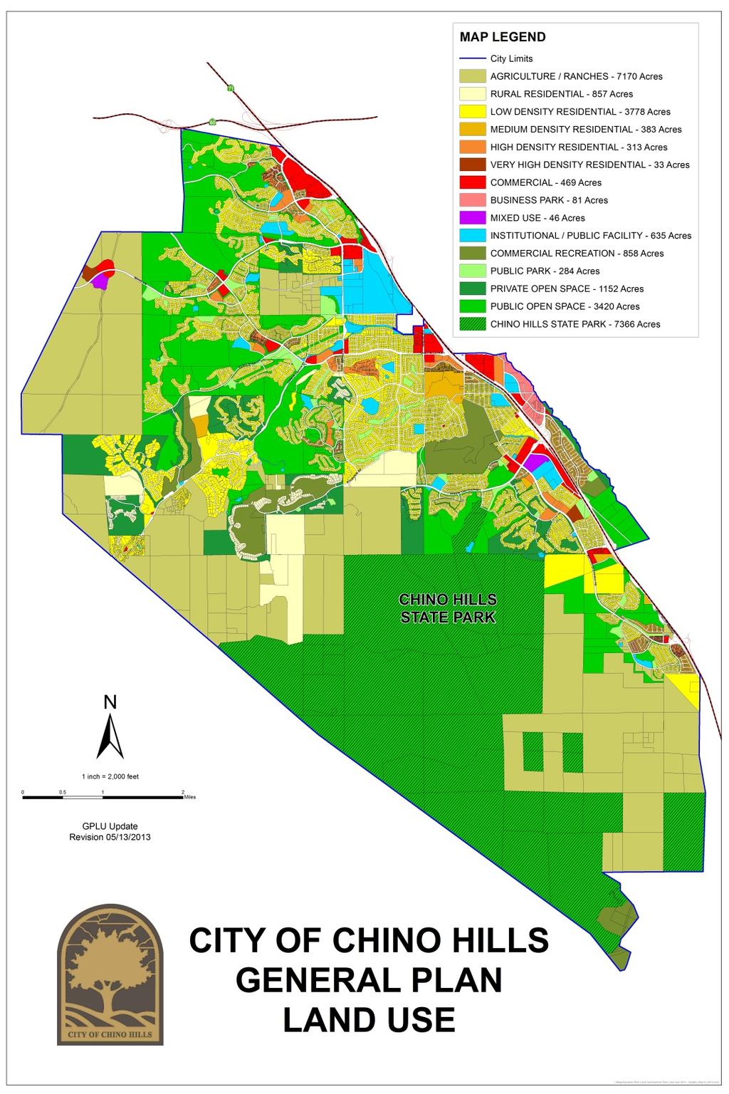
7 Existing Proposed Preliminary Draft
8 Major Land Use Changes Property Name Existing General Plan Designation Proposed General Plan Designation St. Josephs Hill of Hope Institutional Agriculture / Ranches The Santa Barbara Commercial Mixed Use Tres Hermanos (Site 1) Agriculture / Ranches Mixed Use Tres Hermanos (Site 2) Agriculture / Ranches Very High Density Residential Tres Hermanos (Site 3) Agriculture / Ranches & Commercial Commercial McCoy Equestrian Center Open Space Institutional B.A.P.S. Hindu Temple Very High Density Residential Institutional Sleepy Hollow Community Low Density Residential Institutional Building City Hall Parking Structure High Density Residential Institutional


9 Major Land Use Changes St. Josephs Hill of Hope St. Josephs Hill of Hope Existing General Plan Land Use Map Proposed General Plan Land Use Map


10 Major Land Use Changes The Santa Barbara The Santa Barbara Existing General Plan Land Use Map Proposed General Plan Land Use Map
 Tres Hermanos (Site 3) Tres Hermanos")

11 Major Land Use Changes Tres Hermanos (Site 2) Tres Hermanos (Site 3) Tres Hermanos Tres Hermanos (Site 1) Existing General Plan Land Use Map Proposed General Plan Land Use Map


12 Major Land Use Changes McCoy Equestrian Center McCoy Equestrian Center Existing General Plan Land Use Map Proposed General Plan Land Use Map


13 Major Land Use Changes B.A.P.S. Hindu Temple B.A.P.S. Hindu Temple Existing General Plan Land Use Map Proposed General Plan Land Use Map


14 Major Land Use Changes Sleepy Hollow Community Building Existing General Plan Land Use Map Sleepy Hollow Community Building Proposed General Plan Land Use Map


15 Major Land Use Changes City Hall Parking Structure City Hall Parking Structure Existing General Plan Land Use Map Proposed General Plan Land Use Map


16 Example of delineation of Open Space into Public Open Space, Private Open Space, and Public Park land use categories. Public Open Space Open Space Private Open Space Public Park Existing General Plan Land Use Map Proposed General Plan Land Use Map


17 Example of corrected land use designations for sites that have developed or are expected to develop at uses or densities that differ substantially from their existing General Plan land use category. Existing General Plan Land Use Map Proposed General Plan Land Use Map


18 Example of Mapping Error Corrections Existing General Plan Land Use Map Proposed General Plan Land Use Map
19 Update to Land Use Element Text: Transition Planned Development Plan designated properties to traditional zoning consistent with developed use and/or General Plan land use designation and Measure U and other applicable law. Permit clustering of Agriculture/Ranches and Rural Residential properties to protect environmental and visual resources, allowing for reduced minimum lot sizes provided the overall density of the parcel is not increased. Create Mixed Use land use policies.
20 Environmental Impact Report (EIR): Required by the State of California Environmental Quality Act (CEQA) to address the potential environmental impacts of the Project Project is an activity that may case a physical change in the environment Adoption and implementation of the proposed General Plan Update is considered a Project pursuant to CEQA EIR is the most extensive environmental process available under CEQA
21 Purpose of Scoping Meeting: Beginning of the EIR process Inform interested public agencies and the community about the Project Provide information on the EIR process Solicit input on environmental issues to be studied in the EIR
22 EIR Process: City of Chino Hills Initial Study / Notice of Preparation Scoping Technical Studies Draft EIR Planning Commission Public Hearing City Council Public Hearing
23 Schedule: City of Chino Hills Initial Study / Notice of Preparation: May 23, 2013 June 25, 2013 Draft : October 2013 Draft EIR: October 2013 Draft EIR Public Review: 45 Days Public Hearings: December 2013 February 2014
24 Questions? City of Chino Hills EIR Scoping Comments Next Steps Thank you for your interest in the Chino Hills General Plan Update
1.0 PURPOSE AND FORMAT OF THE FINAL EIR
 1.0 PURPOSE AND FORMAT OF THE FINAL EIR 1.1 PROJECT OVERVIEW CEMEX (RMC Pacific Materials, dba CEMEX) operates the Bonny Doon Shale and Limestone Quarries in Santa Cruz County for the production of Portland
TREASURE COAST REGIONAL PLANNING COUNCIL M E M O R A N D U M. To: Council Members AGENDA ITEM 4B10
 TREASURE COAST REGIONAL PLANNING COUNCIL M E M O R A N D U M To: Council Members AGENDA ITEM 4B10 From: Date: Subject: Staff December 14, 2018 Council Meeting Local Government Comprehensive Plan Review
King City URA 6D Concept Plan
 King City URA 6D Concept Plan King City s Evolution Among the fastest growing cities 2000 Census 1,949 2010 Census 3,111 60% increase 2016 Census estimate 3,817 23% increase Average annual rate 4.3% Surpassing
 BPC Policy No , IIM7fyilK Office of the District Clerk TRANSITION ZONE POLICY")
 3 4 5 6 7 8 9 10 11 12 13 14 15 16 17 REDCLIFF MUNICIPAL PLANNING COMMISSION FOR COMMENT/DISCUSSION DATE: TOPIC: April 27 th, 2018 Bylaw 1860/2018, proposed amendments to the Land Use Bylaw regarding cannabis
TABLE OF CONTENTS ARTICLE I. POLK COUNTY COMPREHENSIVE PLAN VOLUME 1. Page CHAPTER 1. GENERAL... A-1
 TABLE OF CONTENTS ARTICLE I. POLK COUNTY COMPREHENSIVE PLAN VOLUME 1 Page CHAPTER 1. GENERAL... A-1 DIVISION 1.100 GENERAL PROVISIONS... A-1 DIVISION 1.200 BASIC PRINCIPLES... A-6 DIVISION 1.300 THE PLANNING
CLAREMONT MASTER PLAN 2017: LAND USE COMMUNITY INPUT
 Planning and Development Department 14 North Street Claremont, New Hampshire 03743 Ph: (603) 542-7008 Fax: (603) 542-7033 Email: cityplanner@claremontnh.com www.claremontnh.com CLAREMONT MASTER PLAN 2017:
GIS in Community & Regional Planning
 GIS in Community & Regional Planning The The role role of of GIS GIS in in Re-writing the the Zoning Bylaw for for the the City City of of Vernon LandInfo Technologies Presentation Overview The GIS Initiative
Date: June 19, 2013 Meeting Date: July 5, Consideration of the City of Vancouver s Regional Context Statement
 Section E 1.5 To: From: Regional Planning and Agriculture Committee Lee-Ann Garnett, Senior Regional Planner Planning, Policy and Environment Department Date: June 19, 2013 Meeting Date: July 5, 2013 Subject:
Contents. Ipswich City Council Ipswich Adopted Infrastructure Charges Resolution (No. 1) Page
 Page") Ipswich City Council Ipswich Adopted Infrastructure Charges Resolution (No. 1) 2014 Contents Page Part 1 Introduction 3 1. Short title 3 2. Commencement 3 3. Sustainable Planning Act 2009 3 4. Purpose
Ipswich City Council Ipswich Adopted Infrastructure Charges Resolution (No. 1) 2014 Contents Page Part 1 Introduction 3 1. Short title 3 2. Commencement 3 3. Sustainable Planning Act 2009 3 4. Purpose
Exhibit IV-1: Initiation of Zoning Map Amendments Case Report HEARING DATE: MAY 3, 2012
 Exhibit IV-1: Initiation of Zoning Map Amendments Case Report HEARING DATE: MAY, 01 Case No.: 00.0MTZU Transit Center District Plan Amendments to Zoning Map Staff Contact: Joshua Switzky - (1) -1 joshua.switzky@sfgov.org
5. Environmental Analysis
 5.9 MINERAL RESOURCES 5.9.1 Methodology The California Geological Survey Mineral Resources Project provides information about California s nonfuel mineral resources. The primary focus of the Mineral Resources
Albuquerque City-wide Zoning Remapping
 Albuquerque City-wide Zoning Remapping Michelle Gricius, City of Albuquerque Planning Department Albuquerque Geographic Information System (AGIS) Division City of Albuquerque Annexation History Albuquerque
PLANNING COMMISSION AGENDA
 COUNTY OF IMPERIAL COMMISSIONERS: Chairman: Rudy Schaffner Dennis Bergh Norm Niver Vice Chairman: Carson Kalin Sergio Cabanas Russell Roben Max Castillo Carlton A. Hargrave Ernesto Medina JIM MINNICK,
MPOs SB 375 LAFCOs SCAG Practices/Experiences And Future Collaborations with LAFCOs
 Connecting LAFCOs and COGs for Mutual Benefits MPOs SB 375 LAFCOs SCAG Practices/Experiences And Future Collaborations with LAFCOs Frank Wen, Manager Research & Analysis Land Use & Environmental Planning
Local Area Key Issues Paper No. 13: Southern Hinterland townships growth opportunities
 Draft Sunshine Coast Planning Scheme Review of Submissions Local Area Key Issues Paper No. 13: Southern Hinterland townships growth opportunities Key Issue: Growth opportunities for Southern Hinterland
Brentwood General Plan Update
 Brentwood General Plan Update Open House Meeting November 14, 2013 De Novo Planning Group Overview The primary purpose of today s Open House is to provide the public with an update of the status of the
Proposed Scope of Work Village of Farmingdale Downtown Farmingdale BOA Step 2 BOA Nomination Study / Draft Generic Environmental Impact Statement
 Proposed Scope of Work Village of Farmingdale Downtown Farmingdale BOA Step 2 BOA Nomination Study / Draft Generic Environmental Impact Statement The scope of work that follows incorporates and covers
HORIZON 2030: Land Use & Transportation November 2005
 PROJECTS Land Use An important component of the Horizon transportation planning process involved reviewing the area s comprehensive land use plans to ensure consistency between them and the longrange transportation
Kitsap County 2016 Comprehensive Plan Update. Appendix A: Growth Estimates
 Kitsap County 2016 Comprehensive Plan Update Appendix A: Growth Estimates Appendix A 1 April 2016 Kitsap County 2016 Comprehensive Plan Update Appendix A: Growth Estimates Land Capacity Land capacity
The National Spatial Strategy
 Purpose of this Consultation Paper This paper seeks the views of a wide range of bodies, interests and members of the public on the issues which the National Spatial Strategy should address. These views
Webinar Series for Comprehensive Plan Updates. School Districts: More than just an affected jurisdiction
 Webinar Series for Comprehensive Plan Updates School Districts: More than just an affected jurisdiction Presented by Tara Beard, AICP March 9, 2017 Goals for this webinar City planning staff are more aware
Public Transportation Infrastructure Study (PTIS) - 2 nd Technical Advisory Committee Meeting
 - 2 nd Technical Advisory Committee Meeting") Public Transportation Infrastructure Study (PTIS) - 2 nd Technical Advisory Committee Meeting Presentation to: Technical Advisory Committee (TAC) Presented by: and Team July 8th, 2009 Public Transportation
Public Transportation Infrastructure Study (PTIS) - 2 nd Technical Advisory Committee Meeting Presentation to: Technical Advisory Committee (TAC) Presented by: and Team July 8th, 2009 Public Transportation
Council Workshop on Neighbourhoods Thursday, October 4 th, :00 to 4:00 p.m. Burlington Performing Arts Centre
 Council Workshop on Neighbourhoods Thursday, October 4 th, 2012 1:00 to 4:00 p.m. Burlington Performing Arts Centre Agenda Introductions Warm-Up Exercise Presentation Exercise Neighbourhood Planning Break
Los Alamos Planning Advisory Committee. Stephen Peterson March 19, 2007
 Los Alamos Planning Advisory Committee Stephen Peterson March 19, 2007 What makes Los Alamos so special? Very small, compact town surrounded by large parcel working agriculture and open space areas Old
COUNTY OF SONOMA PERMIT AND RESOURCE MANAGEMENT DEPARTMENT 2550 Ventura Avenue, Santa Rosa, CA (707) FAX (707)
 FAX (707)") COUNTY OF SONOMA PERMIT AND RESOURCE MANAGEMENT DEPARTMENT 2550 Ventura Avenue, Santa Rosa, CA 95403 (707) 565-1900 FAX (707) 565-1103 DATE : TO: FROM: SUBJECT: July 21, 2009 at 2:30 p.m. Board of Supervisors
COUNTY OF SONOMA PERMIT AND RESOURCE MANAGEMENT DEPARTMENT 2550 Ventura Avenue, Santa Rosa, CA 95403 (707) 565-1900 FAX (707) 565-1103 DATE : TO: FROM: SUBJECT: July 21, 2009 at 2:30 p.m. Board of Supervisors
Economic Activity Economic A ctivity
 5 Economic Economic Activity Activity ECONOMIC ACTIVITY 5.1 EMPLOYMENT... 5-7 5.1.1 OBJECTIVE... 5-7 5.1.2 POLICIES... 5-7 5.2 PROTECTING THE AREA OF EMPLOYMENT... 5-9 5.2.1 OBJECTIVE... 5-9 5.2.2 POLICIES...
State initiative following up the 2006 national planning report
 18 ness districts and public institutions, should be integrated with the opportunities for public transport services. State initiative following up the 2006 national planning report The Ministry of the
OREGON POPULATION FORECAST PROGRAM
 OREGON POPULATION FORECAST PROGRAM PROGRAM OVERVIEW BACKGROUND Beginning in 1973 with the passage of Senate Bill (SB) 100, Oregon s growth management system has relied on population forecasts as the primary
OTTER POINT ADVISORY PLANNING COMMISSION. Notice of Meeting on Tuesday, June 5, 2018 at 7 p.m.
 OTTER POINT ADVISORY PLANNING COMMISSION Notice of Meeting on Tuesday, June 5, 2018 at 7 p.m. Juan de Fuca Local Area Services Building, #3 7450 Butler Road, Otter Point, BC 1. Elections 2. Approval of
9. GEOLOGY, SOILS, AND MINERALS
 June 28, 2018 Page 9-1 9. GEOLOGY, SOILS, AND MINERALS This EIR chapter describes the existing geological, soil, and mineral conditions in the planning area. The chapter includes the regulatory framework
COMMUNITY DEVELOPMENT DEPARTMENT POLICY & PROCEDURE
 COMMUNITY DEVELOPMENT DEPARTMENT POLICY & PROCEDURE Policy No: DSP-OO3 Release Date: January 1, 2014 Effective Date: January 1, 2014 Revision Date: March 1, 2018 TITLE: The City Policy for Site Specific
APPENDIX I - AREA PLANS
 ROUTE 37 WEST LAND USE PLAN ROUTE 37 WEST LAND USE PLAN Recent land use decisions and development trends have drawn attention to the land within the Route 37 western by-pass area between Route 50 and
City of Manitou Springs
 March 2018 City of Manitou Springs Implementing Land Use tools to reduce and mitigate natural hazard risk Context & History Past Present Historic homes Older infrastructure Hillside development Creekside
CORPORATION OF THE CITY OF COURTENAY COUNCIL MEETING AGENDA
 CORPORATION OF THE CITY OF COURTENAY COUNCIL MEETING AGENDA DATE: Monday, January 14, 2013 PLACE: City Hall Council Chambers TIME: 4:00 p.m. 1.00 ADOPTION OF MINUTES 1. Adopt January 7, 2013 Regular Council
CITY OF PORTLAND, TEXAS SERVICE PLAN FOR ANNEXATION AREA
 CITY OF PORTLAND, TEXAS SERVICE PLAN FOR ANNEXATION AREA Location and Acreage Approximately 1,863 acres of land in San Patricio County, located in the ETJ northwest of the existing City Limits. Metes and
Mineral Resources
 Sacramento Local Agency Formation Commission Mineral Resources 3.11 - Mineral Resources 3.11.1 - Introduction This section describes and evaluates potential environmental impacts to mineral resources resulting
MCAS TUSTIN SPECIFIC PLAN ENVIRONMENTAL IMPACT STATEMENT/ENVIRONMENTAL IMPACT REPORT ADDENDUM/INITIAL STUDY. Prepared for: Prepared by:
 GENERAL PLAN AMENDMENT 2013-001, SPECIFIC PLAN AMENDMENT 2013-001, DEVELOPMENT AGREEMENT 2013-002, AND AGREEMENT FOR EXCHANGE OF REAL PROPERTY BETWEEN CITY OF TUSTIN AND SOUTH ORANGE COUNTY COMMUNITY COLLEGE
Land Use Planning and Agriculture: Austrian Experiences and Challenges I
 Land Use Planning and Agriculture: Austrian Experiences and Challenges I SULANET Summer School 2016 Walter Seher BOKU Vienna 1 Land Use Planning and Agriculture 2 Land Use Planning and Agriculture Agriculture
Summary. Recommendations on the Fifth Policy Document on Spatial Planning September 2001
 Summary Recommendations on the Fifth Policy Document on Spatial Planning September 2001 2 Introduction In December 2000 the Dutch Cabinet issued Part 1 of the Fifth National Policy Document on Spatial
Stanislaus County Water Advisory Committee. May 30, 2018
 Stanislaus County Water Advisory Committee May 30, 2018 2018 Hydrologic Conditions and Water Supply Outlook 2018 Water Allocations WEST Federal 45% State 35% CCID 100% EAST SSJID 100% OID
Santa Clara Valley Water District Page 1 of 4
 Santa Clara Valley Water District File No.: 16-0304 Agenda Date: 5/24/2016 Item No.: 2.7. BOARD AGENDA MEMORANDUM SUBJECT: Public Hearing and Resolution on the Decision to Become the Groundwater Sustainability
Date: March 31, 2014 PATE; fyril 2.3,2 >H
 aj BRAMPTON fifs Rower City XH-l-f r.t "»* City Council The Corporation of the City of Brampton SRAMPTON CITY COUNCIL Date: March 31, 2014 PATE; fyril 2.3,2 >H File: POO GR VisWhtoJed ^t'th-meeh'^a Subject:
GIS Geographical Information Systems. GIS Management
 GIS Geographical Information Systems GIS Management Difficulties on establishing a GIS Funding GIS Determining Project Standards Data Gathering Map Development Recruiting GIS Professionals Educating Staff
Preparing the GEOGRAPHY for the 2011 Population Census of South Africa
 Preparing the GEOGRAPHY for the 2011 Population Census of South Africa Sharthi Laldaparsad Statistics South Africa; E-mail: sharthil@statssa.gov.za Abstract: Statistics South Africa (Stats SA) s Geography
TOWARDS STRATEGIC SPATIAL PLANNING IN JAMAICA: THE NATIONAL SPATIAL PLAN
 TOWARDS STRATEGIC SPATIAL PLANNING IN JAMAICA: THE NATIONAL SPATIAL PLAN JIEP 5th Biennial Conference on the Environment: Balancing National Development and Environmental Protection June 6, 2011 Jamaica
Regional Growth Strategy Regional Staff Committee
 Regional Growth Strategy Regional Staff Committee June 21, 2018 1 Overview Summary of June Growth Management Policy Board Regional Growth Strategy Objectives Regional Geographies Regional Growth Strategy
Jordan Harrison, Planner III, San Francisco Recreation and Park Department
 Date November 18, 2015 To: Through: From: Subject: Recreation and Park Commission Philip A. Ginsburg, General Manager Dawn Kamalanathan, Director, Capital & Planning Division Jordan Harrison, Planner III,
A Method for Mapping Settlement Area Boundaries in the Greater Golden Horseshoe
 A Method for Mapping Settlement Area Boundaries in the Greater Golden Horseshoe Purpose This paper describes a method for mapping and measuring the lands designated for growth and urban expansion in the
Committee Meeting November 6, 2018
 Committee Meeting November 6, 2018 Agenda Where we are in the process Land Use Plan Transportation Element Housing & Neighborhoods Elements Next Steps Schedule November 6: Plan Elements December: Plan
Engineer's Report. Main Street Business Area. Festoon Lighting and Sidewalk Cleaning Assessment District (Fiscal Year )
") Engineer's Report for the Main Street Business Area Festoon Lighting and Sidewalk Cleaning Assessment District (Fiscal Year 2008-09) Prepared under the provisions of the Benefit Assessment Act of 1982
Engineer's Report for the Main Street Business Area Festoon Lighting and Sidewalk Cleaning Assessment District (Fiscal Year 2008-09) Prepared under the provisions of the Benefit Assessment Act of 1982
GIS ADMINISTRATOR / WEB DEVELOPER EVANSVILLE-VANDERBURGH COUNTY AREA PLAN COMMISSION
 GIS ADMINISTRATOR / WEB DEVELOPER EVANSVILLE-VANDERBURGH COUNTY AREA PLAN COMMISSION SALARY RANGE INITIATION $43,277 SIX MONTHS $45,367 POSITION GRADE PAT VI The Evansville-Vanderburgh County Area Plan
LANDUSE APPLICATIONS OF EARTHQUAKE HAZARD MAPS CALIFORNIA EXPERIENCE
 LANDUSE APPLICATIONS OF EARTHQUAKE HAZARD MAPS CALIFORNIA EXPERIENCE Thomas C. Vlasic Vice President Spangle Associates Portola Valley, California INTRODUCTION The focus of this report is primarily on
Attachment 3. Updating UBC s Regional Context Statement. University of British Columbia CONSIDERATION MEMORANDUM OF CONSULTATION INPUT
 Attachment 3 University of British Columbia Updating UBC s Regional Context Statement CONSIDERATION MEMORANDUM OF CONSULTATION INPUT Campus and Community Planning February 24, 2014 1 CONSIDERATION MEMORANDUM
Application #: TEXT
 TOWN OF FORT MYERS BEACH 2008 PROPOSED COMPREHENSIVE PLAN AMENDMENTS Application #: 2008-13-TEXT Description: Modify the Coastal Management and Future Land Use Elements to reflect the state s new definition
Introduction to the Gozo & Comino Local Plan
 Introduction to the Gozo & Comino Local Plan What is a Local Plan? A Local Plan is a land use document with written text (policies and justifications) and maps; Reconciles local needs with strategic considerations;
Smart Solutions for Spatial Planning
 Smart Solutions for Spatial Planning Aedas R&D [Computational Design Research] Centre for Evolutionary Computing in Architecture [CECA @ UEL] Knowledge Transfer [breaking silos] * constructing consensus
The Governance of Land Use
 The planning system The Governance of Land Use United Kingdom Levels of government and their responsibilities The United Kingdom is a unitary state with three devolved governments in Northern Ireland,
2040 MTP and CTP Socioeconomic Data
 SE Data 6-1 24 MTP and CTP Socioeconomic Data Purpose of Socioeconomic Data The socioeconomic data (SE Data) shows the location of the population and employment, median household income and other demographic
OFFICIAL GAZETTE OF THE REPUBLIC OF KOSOVA / No. 30 / 23 AUGUST 2013, PRISTINA LAW NO. 04/L-174 ON SPATIAL PLANNING LAW ON SPATIAL PLANNING
 OFFICIAL GAZETTE OF THE REPUBLIC OF KOSOVA / No. 30 / 23 AUGUST 2013, PRISTINA LAW NO. 04/L-174 ON SPATIAL PLANNING Assembly of Republic of Kosovo; Pursuant to Article 65 (1) of the Constitution of Republic
PG&E OFFSHORE CENTRAL COASTAL CALIFORNIA SEISMIC IMAGING PROJECT
 PG&E OFFSHORE CENTRAL COASTAL CALIFORNIA SEISMIC IMAGING PROJECT Public Scoping Meeting California State Lands Commission July 21, 2011 Project Area Project Commitments Assessment of the Hosgri, Shoreline,
Discussion paper on spatial units
 Discussion paper on spatial units for the Forum of Experts in SEEA Experimental Ecosystem Accounting 2018 Version: 8 June 2018 Prepared by: SEEA EEA Revision Working Group 1 on spatial units (led by Sjoerd
REVISED UPDATED PREPARED DIRECT SAFETY ENHANCEMENT COST ALLOCATION TESTIMONY OF GARY LENART SAN DIEGO GAS & ELECTRIC COMPANY AND
 Application No: Exhibit No.: Witness: A.--00 ) In the Matter of the Application of San Diego Gas & ) Electric Company (U 0 G) and Southern California ) Gas Company (U 0 G) for Authority to Revise ) Their
East Bay BRT. Planning for Bus Rapid Transit
 East Bay BRT Planning for Bus Rapid Transit Regional Vision Draper Prison The Bottleneck is a State-Level issue, Salt Lake County 2050 Population: 1.5M Draper Prison hopefully with some State-Level funding!
LARAMIE COUNTY PLANNING & DEVELOPMENT DEPARTMENT
 LARAMIE COUNTY PLANNING & DEVELOPMENT DEPARTMENT Planning Building MEMORANDUM TO: FROM: Laramie County Planning Commission Nancy M. Trimble, Associate Planner DATE: October 26, 2017 TITLE: Review and action
The Future of Met Council Forecasts
 The Future of Met Council Forecasts Todd Graham todd.graham@metc.state.mn.us Dennis Farmer dennis.farmer@metc.state.mn.us Metropolitan Council Research Today s Agenda Why we forecast, how we use forecasts
Growth Management: Analysis of Comments Received and Responses Comments received as of October 16, 2017
 Growth Management: Analysis of Comments Received and s Comments received as of October 16, Comments informing the Region of Peel s growth management work have been summarized with responses below. These
Dark Sky Initiative Draft Terms of Reference
 Dark Sky Initiative Draft Terms of Reference July 2008 Table of Contents 1.0 Introduction 2 2.0 Initiative intent 2-3 3.0 Initiative goals 3 4.0 Legislation 3 5.0 Municipal Development Plan 3 6.0 Land
Proposal for a DIRECTIVE OF THE EUROPEAN PARLIAMENT AND OF THE COUNCIL. establishing an infrastructure for spatial information in the Community
 Proposal for a DIRECTIVE OF THE EUROPEAN PARLIAMENT AND OF THE COUNCIL establishing an infrastructure for spatial information in the Community INSPIRE http://inspire.jrc.it/ Alessandro Annoni 1 EU Commission
Honorable Mayor and Members of the City Council
 TO: ATTENTION: FROM: SUBJECT: Honorable Mayor and Members of the City Council Jeffrey L. Stewart, City Manager Len Gorecki, Director of Public Works Jerry Stock, City Engineer Public Hearing to Consider
Measurement of the Urban-Housing Deficit:
 Measurement of the Urban-Housing Deficit: Strategies, tools and sources of information The International Network for Urban and Regional Statistics Standing Committee of the International Association for
GOVERNMENT MAPPING WORKSHOP RECOVER Edmonton s Urban Wellness Plan Mapping Workshop December 4, 2017
 GOVERNMENT MAPPING WORKSHOP 12.4.17 RECOVER Edmonton s Urban Wellness Plan Mapping Workshop December 4, 2017 In July of 2017, City Council directed administration to develop RECOVER, Edmonton s Urban Wellness
NATURE AND EXTENT OF PROPOSED DEVELOPMENT. Amount of Development Development Zones Distribution of Density Policies
 NATURE AND EXTENT OF PROPOSED DEVELOPMENT Amount of Development Development Zones Distribution of Density Policies DRAFT POOLBEG PLANNING SCHEME Amount of Development 78 4.1 The rationale for the overall
Subject: Note on spatial issues in Urban South Africa From: Alain Bertaud Date: Oct 7, A. Spatial issues
 Page 1 of 6 Subject: Note on spatial issues in Urban South Africa From: Alain Bertaud Date: Oct 7, 2009 A. Spatial issues 1. Spatial issues and the South African economy Spatial concentration of economic
Regional Growth Strategy Work Session Growth Management Policy Board
 Regional Growth Strategy Work Session Growth Management Policy Board September 6, 2018 1 Overview Recap June GMPB work session Objectives and outcomes Regional geographies Growth scenarios Breakout Discussion:
Law on Spatial Planning
 UNITED NATIONS United Nations Interim Administration Mission in Kosovo UNMIK NATIONS UNIES Mission d Administration Intérimaire des Nations Unies au Kosovo PROVISIONAL INSTITUTIONS OF SELF GOVERNMENT Law
APPENDIX D FOLSOM HOLDING CAPACITY METHODOLOGY
 APPENDIX D FOLSOM HOLDING CAPACITY METHODOLOGY This page intentionally left blank. APPENDIX D FOLSOM HOLDING CAPACITY METHODOLOGY 1. INTRODUCTION This document provides a description of the assumptions
Facts and Findings. Exhibit A-1
 Exhibit A-1 Facts and Findings The county periodically prepares coordinated countywide forecasts for all the cities in the county and the unincorporated area. These forecasts can be used by cities as a
Neighbourhood Planning in Haringey. Myddleton Road Strategic Group 7 th November 2013
 Neighbourhood Planning in Haringey Myddleton Road Strategic Group 7 th November 2013 What is Neighbourhood Planning? Neighbourhood Planning, introduced through the Localism Act 2011, offers an opportunity
ENVISIONING OUR CITY: 2041 PUBLIC INFORMATION CENTRE #2 November 16, 2017
 ENVISIONING OUR CITY: 2041 PUBLIC INFORMATION CENTRE #2 November 16, 2017 Purpose of the Public Information Centre The City of Brantford is undertaking three studies to guide future development to 2041
Dar es Salaam - Reality Check Workshop
 Dar es Salaam - Reality Check Workshop hosted by GIZ and Dar es Salaam City Council Introduction: Key Urban Characteristics of Dar es Salaam Challenges and Opportunities for Resilient Development in the
The 3V Approach. Transforming the Urban Space through Transit Oriented Development. Gerald Ollivier Transport Cluster Leader World Bank Hub Singapore
 Transforming the Urban Space through Transit Oriented Development The 3V Approach Gerald Ollivier Transport Cluster Leader World Bank Hub Singapore MDTF on Sustainable Urbanization The China-World Bank
Long Term Plan What is planned for Murchison?
 Long Term Plan 2018-2028 What is planned for Murchison? 1.0 Introduction The following information provides an overview of significant projects Council has planned for the Murchison settlement in the Long
Requirements for a Dark Skies Designation RLEP
 Requirements for a Dark Skies Designation RLEP 2017 Why Consider a Dark Skies Designation? Demonstrates a public commitment to preserving the quality of night skies Is a valuable credential for promoting
4.5 GEOLOGY AND SOILS
 4.5 GEOLOGY AND SOILS This section addresses the project site geology and soils and analyzes potential changes that would result from development of the Wye Specific Plan project. 4.5.1 Environmental Setting
BEFORE THE PUBLIC UTILITIES COMMISSION OF THE STATE OF COLORADO * * * *
 Exhibit No. 1 BEFORE THE PUBLIC UTILITIES COMMISSION OF THE STATE OF COLORADO * * * * IN THE MATTER OF THE APPLICATION OF PUBLIC SERVICE COMPANY OF COLORADO FOR APPROVAL OF ITS 0 ELECTRIC RESOURCE PLAN
Assessment of Sustainable Land Use within the Town Planning Process Experiences with a Multi Criteria Approach (MCA)
") Assessment of Sustainable Land Use within the Town Planning Process Experiences with a Multi Criteria Approach (MCA) Dipl.-Geogr. Sophie Schetke Dipl.-Ing. Benedikt Frielinghaus, University of Bonn, Germany
Assessment of Sustainable Land Use within the Town Planning Process Experiences with a Multi Criteria Approach (MCA) Dipl.-Geogr. Sophie Schetke Dipl.-Ing. Benedikt Frielinghaus, University of Bonn, Germany
Integrated Infrastructure Planning & Spatial Mapping
 Integrated Infrastructure Planning & Spatial Mapping Presenter: Heidi Dixon, Principal Social Planner, DTPLI 23 May 2014 PART 1 PLAN MELBOURNE : Metropolitan Planning Strategy PART 2 Case Study: DTPLI
16540/14 EE/cm 1 DG E 1A
 Council of the European Union Brussels, 5 December 2014 (OR. en) 16540/14 ENV 965 CULT 139 NOTE From: To: Subject: General Secretariat of the Council Delegations Charter of Rome on Natural and Cultural
Tourist-Accommodation (T-A) Zone
 Zone") DRAFT September 12, 2017 Tourist-Accommodation (T-A) Zone Chelan Comprehensive Plan & Municipal Code Update Draft September 12, 2017 Overview... 1 T-A Zone Acreage and Developable Land... 1 Conditions...
DRAFT September 12, 2017 Tourist-Accommodation (T-A) Zone Chelan Comprehensive Plan & Municipal Code Update Draft September 12, 2017 Overview... 1 T-A Zone Acreage and Developable Land... 1 Conditions...
Noise Maps, Report & Statistics, Dublin City Council Noise Mapping Project Roads and Traffic Department
 Noise Maps, Report & Statistics, Dublin City Council Noise Mapping Project Roads and Traffic Department Produced by Traffic Noise & Air Quality Unit November 2007 Contact: brian.mcmanus@dublincity.ie Ph;
City and SUMP of Ravenna
 City and SUMP of Ravenna Nicola Scanferla Head of Mobility Planning Unit, Municipality of Ravenna nscanferla@comune.ra.it place your logo here 19 April, 2017 1st Steering Committee Meeting, Nicosia, Cyprus
Snow and Ice Removal
 Policy # 6.6 Procedure # - Replaces 5.10 & 5.10A Revises - Date Approved February 10, 2014 Method of Approval Resolution #17 1. PRINCIPLES The City of Dauphin desires to maintain the City streets, lanes,
Chapter 3. Planning Constraints & Boundaries
 Chapter 3 Planning Constraints & Boundaries Table of Contents Page A. Introduction...3-1 B. Purpose and Authority...3-6 C. The Rio Vista Principles: Implementing the Community Vision...3-9 D. Setting...3-10
APPENDIX I: Traffic Forecasting Model and Assumptions
 APPENDIX I: Traffic Forecasting Model and Assumptions Appendix I reports on the assumptions and traffic model specifications that were developed to support the Reaffirmation of the 2040 Long Range Plan.
The Governance of Land Use
 The planning system Levels of government and their responsibilities The Governance of Land Use COUNTRY FACT SHEET NORWAY Norway is a unitary state with three levels of government; the national level, 19
TOWARDS THE DEVELOPMENT OF A MONITORING SYSTEM FOR PLANNING POLICY Residential Land Uses Case study of Brisbane, Melbourne, Chicago and London
 TOWARDS THE DEVELOPMENT OF A MONITORING SYSTEM FOR PLANNING POLICY Residential Land Uses Case study of Brisbane, Melbourne, Chicago and London Presented to CUPUM 12 July 2017 by Claire Daniel Urban Planning/Data
Making maps: Traditions and perceptions in Europe. European spatial planning and cartographic representations
 ESPON Create Europe! Making maps: Traditions and perceptions in Europe Dr. Stefanie Dühr University of the West of England, Bristol, UK European spatial planning and cartographic representations Scenarios.
St. Mary s County Comprehensive Zoning Ordinance. Article 5. REGULATION OF USES. Schedule 50.4 Use Classifications. Legend
 St. Mary s County Comprehensive Zoning Ordinance Article 5. REGULATION OF USES Schedule 50.4 Use Classifications Legend P Use is permitted in accordance with Chapter 51 General Standards L Use is permitted
CERTIFIED RESOLUTION. introduction: and dated May 29, 2017, as attached, as appropriate
 15322 Buena Vista Avenue, White Rock BC, Canada V4B 1Y6 www.whiterockcity.ca City of White Rock P: 604.541.22121 F: 604.541.9348 /2tC% City Clerk s Office IT E ROC K June 13,2017 Stephanie Lam, Deputy