Management of Spartina anglica in the Fraser River estuary, British Columbia
|
|
|
- Tiffany Booker
- 6 years ago
- Views:
Transcription
1 Management of Spartina anglica in the Fraser River estuary, British Columbia Gary Williams GL Williams & Associates Ltd. White Rock & Surrey Naturalists Society May 12 th, 2005 White Rock, BC
2 Presentation Outline Origin of S. anglica in England Identifying S. anglica Comparison with native species Fraser Delta management efforts
3 Origin of S. anglica S. maritima (native to SE England) S. alterniflora (Atlantic US ballast water) native & introduced species hybridized sterile F1 hybrid = S. townsendii fertile amphidiploid = S. anglica (through chromosome doubling) Hybrid Vigour higher rates of photosynthesis Increased sediment accretion More frequent tidal submergence

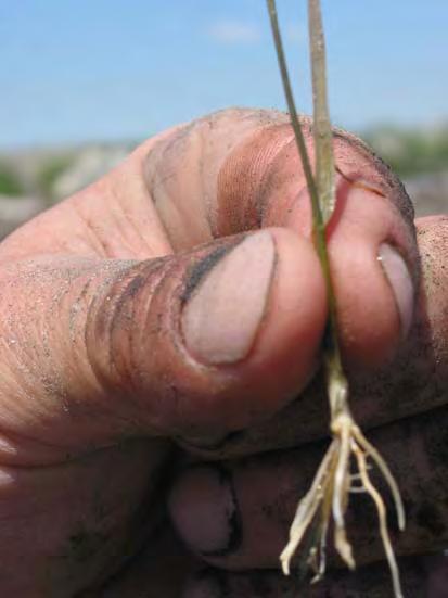
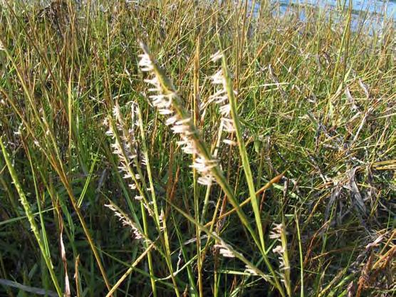
4 S. anglica (English cordgrass)
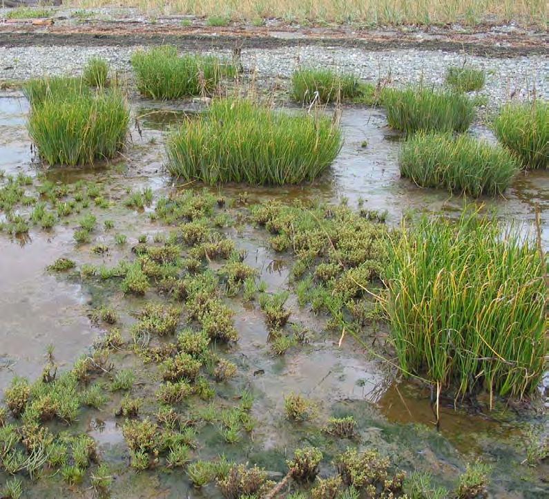
5 Comparison with Native Species Scirpus maritimus (seacoast bulrush) Salicornia virginica (pickleweed) Triglochin maritimum (seacoast arrowgrass) Distichlis spicata (saltgrass) Leymus (Elymus) mollis (dunegrass)

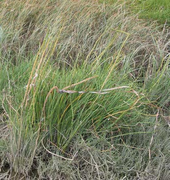
6 seacoast bulrush, Scirpus maritimus
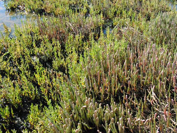
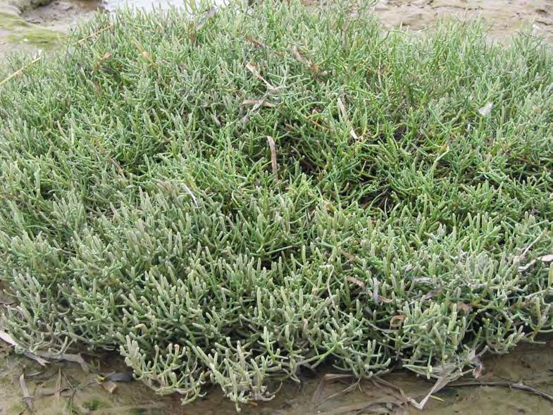
7 Pickleweed, Salicornia virginica
8 arrowgrass, Triglochin maritimum

9 saltgrass, Distichlis spicata
")
10 dunegrass, Leymus (Elymus) mollis
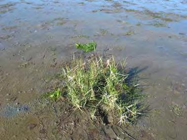
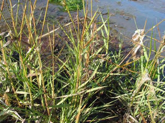
11 Ecological Impacts of S. anglica Hybrid of S. maritima & S. alterniflora spread to 120 countries Aggressive invasive species replaces mudflats with mono culture reduces fish and waterfowl habitat accumulates sediments alters tidal drainage (mudflats & upland) out-competes native salt marsh species

12 Ecological Perspective Needed for Invasive Species Management

13 S. anglica a Regional Problem

14 Estuarine Nearshore Functions
15 Marine Nearshore Food Web
16 Steering Committee Pat Lim, Fisheries & Oceans Canada Kathleen Moore, Canadian Wildlife Service Dan Buffett, Ducks Unlimited Canada Verne Kucy, Corporation of Delta Ron Goldstone, BC Water Lands and Air Protection Tasha Murray, Vancouver Aquarium Juergen Baumann, Vancouver Port Authority Gary Williams, GL Williams & Associates Ltd. Wayne Mather, Greater Vancouver Regional District Kyle Murphy, WA Department of Agriculture Dave Heimer, WA Depart. of Fish and Wildlife Laural Shiner, Whatcom Cty. Noxious Weed Board Sally Hacker, Oregon State University Keeley O Connell, People for Puget Sound
17 Principles of Control Program Avoid the use of chemical herbicides high sensitivity of habitats difficult and lengthy process to obtain permits S. anglica infestation small enough for complete removal rapid, intensive response WA 2003 treated 6,000 acres at a cost of $1.5 million
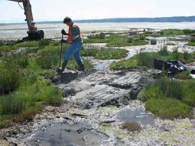
18 S. anglica Management Program Identification & information review GW discovered in August 2003 Spartina key & DNA analysis Inventory & Planning Fraser estuary and Burrard Inlet GPS & GIS mapping (walking/hovercraft) Removal Manual and mechanical Outreach and Education NGO s, municipalities, conferences
19 S. anglica Identification California Coastal Conservancy Barkworth (2003) S. Riggs, Padilla Bay National Estuarine Research Reserve Cindy Sayre, UBC Herbarium D. Ayres, Univ. CA, DNA analysis
 S.")
20 DNA Analysis (courtesy D. Ayres) Gel image of S. anglica (first 2 lanes) and S. alterniflora x foli hybrids Band is absent in S. alterniflora (and S. foli) S. maritima band in S. anglica


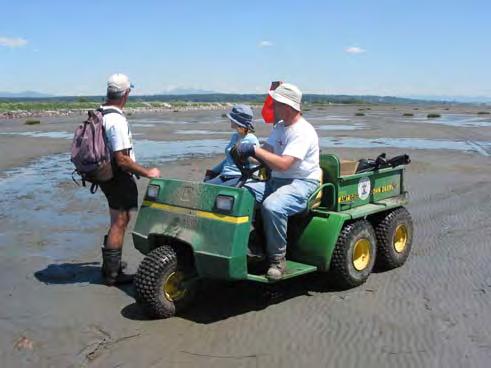
21 Hovercraft Inventory Hovercraft surveys Nov Oct. 2004
22 Distribution in Boundary Bay & Roberts Bank

23 Area of Impact of Impact

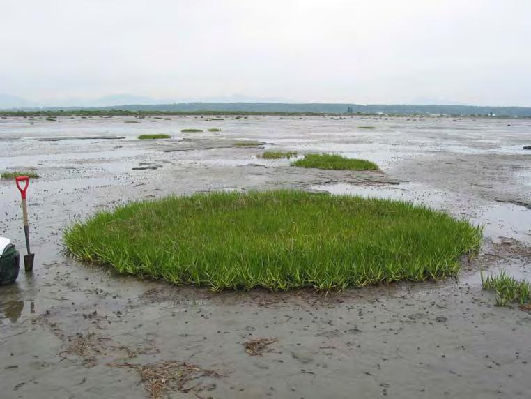
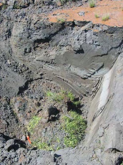
24 Regrowth of S. anglica


25 2003 Roberts Bank Manual Removal


26 2004 Manual Removal Methods
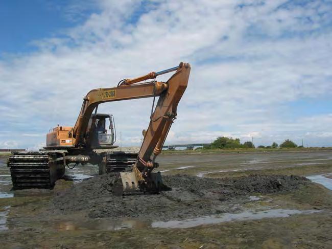
27 2004 Mechanical Removal (in situ burial)
28 Schedule of Spartina Removal Date Manual Removal Roberts Bank Excavator Boundary Bay Manual Removal Excavator Sep Oct. 24, 2003 Jun , 2004 Jun. 23, 2004 Aug. 3 & 12, 2004 Aug. 5, 2004 Sep. 2, 2004 Sep. 25, 2004 Oct clip seedheads
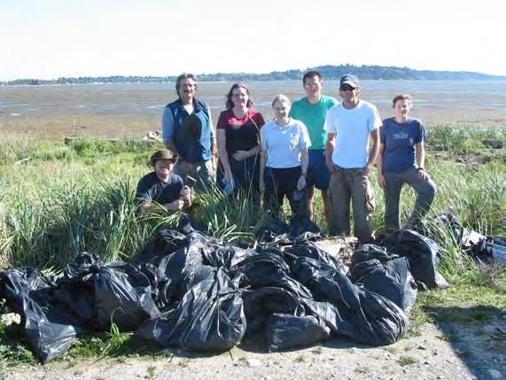
29 Costs for 2004 Program $39,000 for consulting, excavator, materials, labour, and equipment $79,000 in-kind support Combined costs of $118,000 Removed over 7500 kg of Spartina Estimated Area: 248 ha Roberts Bank = 65 ha (0.2 ha solid) Boundary Bay = 183 ha (1.4 ha solid)
30 Funding Vancouver Port Authority Environment Canada, Canadian Wildlife Service Ducks Unlimited Canada Fisheries and Oceans Canada Greater Vancouver Regional District Water Land and Air Protection Western Regional Panel BC Inter-Ministry Invasive Plant Committee
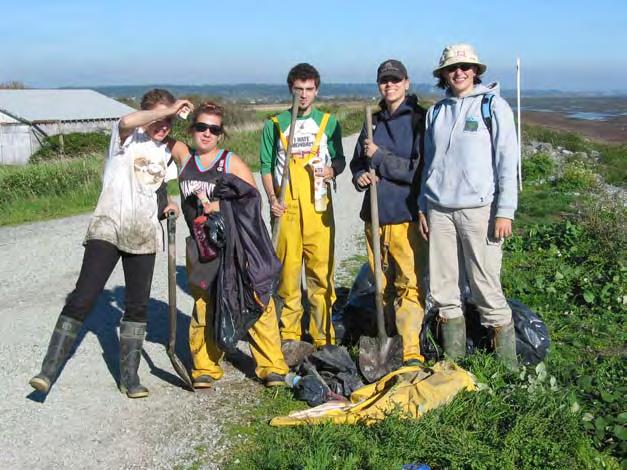
31 Volunteers Over 100 volunteers Vancouver Aquarium, Riverworks Langley Environmental Partners Society The Nature Trust Puget Sound Action Team Northwest Wildlife Whatcom County UBC student Plus numerous individuals from Steering Committee agencies
32 A Matter of Choices
British Columbia Spartina Eradication Program 2009 Progress Report
 British Columbia Spartina Eradication Program 2009 Progress Report Prepared by: Ducks Unlimited Canada (February 2010) Contact: Claire de la Salle Address: 511 13370 78 th Ave Surrey BC V3W 0H6 Phone:
T aanu Telegram. SCWG is in its Third Year! Eelgrass Festival Plans Underway. Issue No.3 December 2004
 T aanu Telegram A NEWSLETTER ABOUT EELGRASS CONSERVATION IN BRITISH COLUMBIA Issue No.3 December 2004 T aanu is Haida for eelgrass The Seagrass Conservation Working Group (SCWG) has been working to conserve
Community Mapping Network. Selected Coastal Atlases and Information Systems in British Columbia, Canada
 Community Mapping Network Selected Coastal Atlases and Information Systems in British Columbia, Canada Outline Community Mapping Network cmnbc.ca Pacific Coastal Resources Atlas for BC cmnbc.ca The Living
Modeling habitat suitability for the European green crab using the ShoreZone mapping system
 Modeling habitat suitability for the European green crab using the ShoreZone mapping system Jodi N. Harney, Ph.D. and John R. Harper, Ph.D. Coastal and Ocean Resources Inc. Mary Morris, R.P. Bio. Archipelago
SPARTINA. 1. Description of the problem. Location of the case-study
 SPARTINA 1. Description of the problem Location of the case-study In New Zealand, spartina is making an impact in Northland, Southland, Marlborough and the Bay of Plenty. This case study focuses mainly
USGS efforts to model sea-level rise impact to tidal marshes along the California coast.
 USGS efforts to model sea-level rise impact to tidal marshes along the California coast. Karen Thorne 1 J.Y Takekawa 1, K. Buffington 1, K. Swanson 2, J. Drexler 2, D.Schoellhamer 2, M. Casazza 3, and
3.7 VISUAL RESOURCES Environmental Setting
 2 3 4 5 6 7 8 9 0 2 3 4 5 6 7 8 9 20 2 22 23 24 25 26 27 28 29 30 3 32 33 34 35 36 37 38 39 40 4 3.7 VISUAL RESOURCES This section assesses the effects of the treatment techniques on views from public
Key to West Coast Spartina Species Based on Vegetative Characters
 Glossary Accuminate - tapering to a sharp tip and having concave sides just before the tip. Caespitose - growing in tufts. Glabrous - having a smooth, shiny surface. Internode - the region of a stem between
This material is contributed by David Giblin. It is a great introduction about the UW herbarium research, but contents of this presentation will be
 This material is contributed by David Giblin. It is a great introduction about the UW herbarium research, but contents of this presentation will be on the lecture exam. Floristics Research at the University
Oyster Reef for Shoreline Stabilization and Restoration. Jason Kirkpatrick Conservation Program Manager MacDill AFB Tampa, Florida
 Oyster Reef for Shoreline Stabilization and Restoration Jason Kirkpatrick Conservation Program Manager MacDill AFB Tampa, Florida Interbay Penninsula Port of Tampa X The few remaining mangroves are being
Research Background: Researcher Sam Bond taking Sediment Elevation Table (SET) measurements in the marsh. A view of salt marsh hay growing in a marsh
 measurements in the marsh. A view of salt marsh hay growing in a marsh") Name Keeping up with the sea level Featured scientist: Anne Giblin from the Marine Biological Laboratory and the Plum Island Ecosystems Long-Term Ecological Research site Research Background: Salt marshes
Name Keeping up with the sea level Featured scientist: Anne Giblin from the Marine Biological Laboratory and the Plum Island Ecosystems Long-Term Ecological Research site Research Background: Salt marshes
Pablo Bay in Sonoma, Solano, and Napa Counties. It is owned and managed by the U.S. Fish and Wildlife
 Appendix L San Pablo Bay Marsh Introduction San Pablo Bay National Wildlife Refuge marsh (hereafter San Pablo) is located on the north shore of San Pablo Bay in Sonoma, Solano, and Napa Counties. It is
Vancouver Island Spartina Eradication Program 2012 Progress Report
 Vancouver Island Spartina Eradication Program 2012 Progress Report Submitted By: Alison Millham, Coastal Invasive Plant Committee and Steven Godfrey, Vancouver Island Conservation Lands Management Program
7.34 Spartina (Spartina anglica)
") 7.34 Spartina (Spartina anglica) Why is it a threat? Spartina is a sward forming grass that originates from the United Kingdom. It grows from underground rhizomes. The rhizomes break off and establish
7.34 Spartina (Spartina anglica) Why is it a threat? Spartina is a sward forming grass that originates from the United Kingdom. It grows from underground rhizomes. The rhizomes break off and establish
Overview of Methods. Terrestrial areas that are most important for conservation Conservation
 Overview of Methods The goal of the Western Lake Erie Coastal Conservation Vision project (WLECCV) is to define where we should be working locally to optimally achieve regional conservation impact. The
Sea Level Rise Providing Nature A-Right-of Way
 Sea Level Rise Providing Nature A-Right-of Way Study Area Site 2: Skagit Bay Initial Condition 11.2 Inches by 2050 No Dikes 27.3 Inches by 2100 No Dikes The Problem Loss of coastal wetlands due to submergence
Wetland Sediment Dynamics at Crissy Field Marsh Annual Report
 Wetland Sediment Dynamics at Crissy Field Marsh 27 Annual Report John Callaway Department of Environmental Science University of San Francisco 217 Fulton St. San Francisco, CA 94117 (415) 422-572 callaway@usfca.edu
Adaptation to Sea Level Rise A Regional Approach
 Adaptation to Sea Level Rise A Regional Approach Project Partners: in Saco Bay, ME Peter Slovinsky, Marine Geologist Maine Geological Survey, Department of Conservation Project Funding from: Saco Bay Hazards
Mapping Predicted Tidal Exposure Durations Using a MLLW-Referenced LiDAR Terrain Model
 Mapping Predicted Tidal Exposure Durations Using a MLLW-Referenced LiDAR Terrain Model for Management of Spartina alterniflora in Willapa Bay, Washington Meeting the Challenge: Invasive Plants in PNW Ecosystems
by J. Balke RP Bio Ecofocus Environmental Consultants
 Dense-flowered Cordgrass Spartina densiflora Regeneration Removal Denman & Hornby Islands Winter 2015-2016 Report Submitted to D. Buffett & M. Christensen Ducks Unlimited by J. Balke RP Bio Ecofocus Environmental
Using Remote Sensing to Map the Evolution of Marsh Vegetation in the South Bay of San Francisco
 Using Remote Sensing to Map the Evolution of Marsh Vegetation in the South Bay of San Francisco Brian Fulfrost Design, Community and Environment (DC&E) 6 th Annual Bay-Delta Science Conference PROJECT
Planning for the Future of Humboldt Bay: Sea Level Rise, Sediment Management, Sand Spits and Salt Marshes. Joel Gerwein
 Planning for the Future of Humboldt Bay: Sea Level Rise, Sediment Management, Sand Spits and Salt Marshes Joel Gerwein Introduction to Humboldt Bay Setting Economy, community, and environment Sediment
Bob Van Dolah. Marine Resources Research Institute South Carolina Department of Natural Resources
 Bob Van Dolah Marine Resources Research Institute South Carolina Department of Natural Resources Shoreline Change Will Occur! On our front beaches where it is not easy to retreat Shoreline Change Will
Armoring on Puget Sound: Progress towards a better baseline
 Western Washington University Western CEDAR Salish Sea Ecosystem Conference 2016 Salish Sea Ecosystem Conference (Vancouver, BC) Armoring on Puget Sound: Progress towards a better baseline Hugh Shipman
3.0 ROBERTS BANK TIDAL FLAT MORPHOLOGY
 Vancouver Port Authority Northwest Hydraulic Consultants Ltd. /Triton Consultants Ltd. Roberts Bank Container Expansion File: 33863 Coastal Geomorphology Study - 19 - November 2004 3.0 ROBERTS BANK TIDAL
The Systems Approach. Alun Williams, ABPmer
 The Systems Approach Alun Williams, ABPmer Overview What is A Systems Approach? Behavioural / Qualitative Modelling? System Definition / Mapping (Behavioural Statements Objective) What is a Systems Approach?
The international patterns of spatial planning system and choice of China. Cai yumei China land use planning and surveying institute (China, beijing)
") FIG Working Week, Rome, Italy 6 10 May 2012 The international patterns of spatial system and choice of China Cai yumei China land use and surveying institute (China, beijing) Outline Background Problem
FIG Working Week, Rome, Italy 6 10 May 2012 The international patterns of spatial system and choice of China Cai yumei China land use and surveying institute (China, beijing) Outline Background Problem
RANGE AND ANIMAL SCIENCES AND RESOURCES MANAGEMENT - Vol. II - Catchment Management A Framework for Managing Rangelands - Hugh Milner
 CATCHMENT MANAGEMENT A FRAMEWORK FOR MANAGING RANGELANDS Hugh Milner International Water Management Consultant, Australia Keywords: Rangeland management; catchments and watersheds; catchment management
The Weed Battle. Sage Fitch, Salt Lake County Weed Specialist
 The Weed Battle Noxious and Invasive Weed Management by The Salt Lake County Weed Program and The Bonneville CWMA Sage Fitch, Salt Lake County Weed Specialist Our program & our partners Who are we and
NOAA s OCM: Services, tools and collaboration opportunities & Puerto Rico s NE Marine Corridor as a case study
 NOAA s OCM: Services, tools and collaboration opportunities & Puerto Rico s NE Marine Corridor as a case study Dr. Antares Ramos Álvarez NOAA s Office of Coastal Management September 15 th, 2016 Conservation
Coastal Tidal Marshes
 Virginia s Wetlands Coastal Tidal Marshes Hydrology driven by lunar tides; Stresses include tidal inundation and/or salts; Found along high latitudes along intertidal coasts; Comprise ~ 70% wetlands of
Kootenai River Habitat Restoration Program Update
 Kootenai River Habitat Restoration Program Update Kootenai Tribe of Idaho Kootenai Valley Resource Initiative November 19, 2012 Bonners Ferry, Idaho Changes to Kootenai Basin Beaver trapping Floodplain
Presentation Outline. Project Overview. Sea Level Rise Assessment & Decision Tools. Community Engagement. Tina Whitman, Friends of the San Juans
 Healthy Beaches for People & Fish Sea Level Rise Adaptation Tools for San Juan County, WA Tina Whitman & Andrea MacLennan December 10, 2015 Presentation Outline Project Overview Tina Whitman, Friends of
Port Cities Conference: How Regional Planning can Help Support a Competitive Port. Christina DeMarco Metro Vancouver
 Port Cities Conference: How Regional Planning can Help Support a Competitive Port Christina DeMarco Metro Vancouver June 12. 2008 Metro Vancouver Regional Growth Management Three ways to help support the
Lower South Fork McKenzie River Floodplain Enhancement Project
 Lower South Fork McKenzie River Floodplain Enhancement Project McKenzie River Ranger District Willamette National Forest Project Location The project is located in the South Fork McKenzie River Watershed,
Virginia Shoreline Mapping Tools
 Virginia Shoreline Mapping Tools December 15, 2017 Karen Duhring Center for Coastal Resources Management Virginia Institute of Marine Science College of William & Mary Virginia Shoreline Mapping Tools
Factors Governing Successful Tidal Wetland Mitigation. Walter I. Priest, III Wetland Design and Restoration ASWM Webinar 16 July 2018
 Factors Governing Successful Tidal Wetland Mitigation Walter I. Priest, III Wetland Design and Restoration ASWM Webinar 16 July 2018 Goals and Objectives Successful Tidal Wetland Mitigation Primary production
Getting Biodiversity Data
 Getting Biodiversity Data NatureServe Canada Douglas Hyde Executive Director Value of biodiversity data to business? Reasons vary depending on the business Reduce development uncertainty Integrated views
Sediment Management in the Coastal Bays
 Sediment Management in the Coastal Bays Introduction Need for ecosystem view of sediment management in Coastal Bays Island loss and restoration Navigation needs Habitat Trade offs Living Shoreline Requirements
The Use of Geographic Information Systems to Assess Change in Salt Marsh Ecosystems Under Rising Sea Level Scenarios.
 The Use of Geographic Information Systems to Assess Change in Salt Marsh Ecosystems Under Rising Sea Level Scenarios Robert Hancock The ecological challenges presented by global climate change are vast,
I INVASIVE SPARTINA IN WEST COAST ESTUARIES I
 I INVASIVE SPARTINA IN WEST COAST ESTUARIES I ESTUARINE WATERS SUSTAIN A LARGE COMMUNITY OF CONSUMERS, from single-cell plankton, worms, crabs, oysters, fish, and birds to humans. They are highly productive,
Briggs Lake Water Quality Report 2014
 Briggs Lake Water Quality Report 2014 Seasonal Report for Briggs Lake Green Oak Township, Livingston Co. T1N, R6E, Sec. 3,4 74 Surface Acres 414 Hadley Street Holly, MI 48442 Main Phone: 248-634-8388 Northern
HAIDA GWAII CLIMATE ASSESSMENT 2010 Special Report for MIEDS Franc Pridoehl
 HAIDA GWAII CLIMATE ASSESSMENT 2010 Special Report for MIEDS Franc Pridoehl INTRODUCTION Climatic conditions have varied considerably on Haida Gwaii over the past centuries and millennia (Hebda 2007).
A Geographic Information System Based Model John L Marshall Geography 562 GIS Coastal Resources - Final Project: Fall 2017 University of Washington
 EFFECTS OF OYSTER CULTURE ON NATIVE EELGRASS AND RELATED NATURAL RESOURCES IN THE PUGET SOUND A Geographic Information System Based Model John L Marshall Geography 562 GIS Coastal Resources - Final Project:
The Refugia Concept: Using Watershed Analysis to Prioritize Salmonid Habitat for Conservation and Restoration
 The Refugia Concept: Using Watershed Analysis to Prioritize Salmonid Habitat for Conservation and Restoration Christopher May Battelle & UW Cumulative Impacts of Urbanization Landscape Alterations Loss
B.C. s Offshore Oil and Gas: a Guide to the Geology and Resources.
 B.C. s Offshore Oil and Gas: a Guide to the Geology and Resources. Introduction Beneath the offshore regions of British Columbia are four moderately large, geologically young sedimentary basins (Figure
Salt Marsh Habitat Restoration Plan (Revision #3)
") Salt Marsh Habitat Restoration Plan (Revision #3) Moffett Field Naval Air Station Installation Restoration Site 25 Mountain View, California Prepared For: Mr. Robert Lindfors, P.E. ITSI, Inc. 2730 Shadelands
Salt Marsh Habitat Restoration Plan (Revision #3) Moffett Field Naval Air Station Installation Restoration Site 25 Mountain View, California Prepared For: Mr. Robert Lindfors, P.E. ITSI, Inc. 2730 Shadelands
Flowering Rush (Butomus umbellatus) in Flathead Lake and River: An Integrated Invasive Plant Management Project
 in Flathead Lake and River: An Integrated Invasive Plant Management Project") Flowering Rush (Butomus umbellatus) in Flathead Lake and River: An Integrated Invasive Plant Management Project Mara Johnson, Center for Invasive Plant Management; Peter Rice, University of Montana; Virgil
Flowering Rush (Butomus umbellatus) in Flathead Lake and River: An Integrated Invasive Plant Management Project Mara Johnson, Center for Invasive Plant Management; Peter Rice, University of Montana; Virgil
SUMMARY REPORT SHARING NATURAL RESOURCE INFORMATION
 Community Mapping Network SUMMARY REPORT SHARING NATURAL RESOURCE INFORMATION Community Mapping Network Summary Report Table of Contents WHY THIS DOCUMENT?...ERROR! BOOKMARK NOT DEFINED. AN INTRODUCTION
Current and Future Technology Applications for Coastal Zone Management. Bruce K. Carlisle, Acting Director Office of Coastal Zone Management
 Current and Future Technology Applications for Coastal Zone Management Bruce K. Carlisle, Acting Director Office of Coastal Zone Management The Massachusetts Coastal Zone Management Program Approved in
Ballinskelligs Bay and Inny Estuary SAC (site code 335) Conservation objectives supporting document -coastal habitats
 Conservation objectives supporting document -coastal habitats") Ballinskelligs Bay and Inny Estuary SAC (site code 335) Conservation objectives supporting document -coastal habitats NPWS Version 1 April 2014 Table of Contents Page No. 1 Introduction 2 2 Conservation
Ballinskelligs Bay and Inny Estuary SAC (site code 335) Conservation objectives supporting document -coastal habitats NPWS Version 1 April 2014 Table of Contents Page No. 1 Introduction 2 2 Conservation
Janet Walker Understanding the non-trophic effects of animals on community dynamics in California salt marshes
 Janet Walker Understanding the non-trophic effects of animals on community dynamics in California salt marshes I. Introduction Animals influence community structure and ecosystem function via trophic interactions.
New Invasives and Other Weeds to Worry About. Clallam County Noxious Weed Control Program
 New Invasives and Other Weeds to Worry About Clallam County Noxious Weed Control Program What s wrong with Noxious Weeds? Numerous Impacts Reduce crop value or production Pose hazard to humans and animals
Appendix 10: Non-Potential of Natural Gas Hydrate Occurrence in Queen Charlotte Basin8
 British Columbia Offshore Hydrocarbon Development Appendix 10: Non-Potential of Natural Gas Hydrate Occurrence in Queen Charlotte Basin8 Natural gases such as methane, ethane, propane typically occur as
Types of Wetlands. Tidal Systems
 Types of Wetlands Tidal Systems 1 COASTAL WETLAND ECOSYSTEMS Tidal Salt Marshes Tidal Freshwater Marshes Mangrove Wetlands 2 Tidal Estuarine Wetland 3 Definition and Formation of Estuaries Estuary: : partially
Subtidal permanently flooded with tidal water. Irregularly exposed surface exposed by tides less often than daily
 Types of Wetlands Tidal Systems COASTAL WETLAND ECOSYSTEMS Tidal Salt Marshes Tidal Freshwater Marshes Mangrove Wetlands Tidal Estuarine Wetland 1 Definition and Formation of Estuaries u Estuary : partially
Table of Contents. Monitoring of Spartina References Table of Figures
 Table of Contents Monitoring of Spartina 2010 2014... 1 Mapping 2010... 1 Methodology and results... 1 Potential errors and limitations... 1 Re-mapping 2014... 1 Methodology... 2 Errors and limitations...
South Carolina Coastal Habitats
 South Carolina Coastal Habitats By C. Livingston, 2009 Earth Where is South Carolina? North America United States of America SC Here we are! South Carolina borders the Atlantic Ocean. Did you know? South
PROPOSED UNESCO FUNDY BIOSPHERE RESERVE
 OVERVIEW PROPOSED UNESCO FUNDY BIOSPHERE RESERVE NEW BRUNSWICK, CANADA NOMINATION DOCUMENT April 10, 2007 The United Nations Educational, Scientific and Cultural Organization (UNESCO) Man and the Biosphere
I. Tidal Salt Marshes (TSMs)
") NREM 665 Salt Marshes 2 I. Tidal Salt Marshes (TSMs) A. Def: halophytic grassland & dwarf brushwood on alluvial sediments bordering saline H 2 O bodies whose H 2 O level fluctuates tidally (Beeftink 1977)
NREM 665 Salt Marshes 2 I. Tidal Salt Marshes (TSMs) A. Def: halophytic grassland & dwarf brushwood on alluvial sediments bordering saline H 2 O bodies whose H 2 O level fluctuates tidally (Beeftink 1977)
UC San Diego Research Final Reports
 UC San Diego Research Final Reports Title Dynamics and Ecosystem threats of Bidirectional Cordgrass Hybridization in San Francisco Bay Permalink https://escholarship.org/uc/item/6wc6v44s Authors Strong,
Relatively little hard substrate occurs naturally in the
 CHAPTER FIVE Rock Habitats Relatively little hard substrate occurs naturally in the estuary, owing mainly to the vast quantities of fine sediment that have been deposited by the rivers. Rock habitat is
Feasibility Study for Potential Removal of McLane & Goldman Dams Souhegan River, Milford, NH. Public Kick-off Meeting
 Feasibility Study for Potential Removal of McLane & Goldman Dams Souhegan River, Milford, NH Public Kick-off Meeting Mark Wamser Gomez and Sullivan Engineers, P.C. 603-428-4960 Aug 16, 2010 Agenda Opening
WEED WATCH LEEANNE MILA EL DORADO COUNTY DEPARTMENT OF AGRICULTURE
 WEED WATCH LEEANNE MILA EL DORADO COUNTY DEPARTMENT OF AGRICULTURE YELLOW STARTHISTLE WHY DO WE CARE ABOUT INVASIVE WEEDS? HIGHLY AGGRESSIVE DISPLACE NATIVES AND DESIRABLE PLANTS DECREASE WILDLIFE HABITAT
Taunton River Salt Marsh Assessment Results from 2014 season
 Taunton River Salt Marsh Assessment Results from 2014 season December, 2014 During the late summer and fall of 2014, Save The Bay evaluated salt marshes in Assonet Bay, Freetown and Broad Cove in Dighton
Applying GIS to Coastal Management in Cork Harbour: the Corepoint experience
 Applying GIS to Coastal Management in Cork Harbour: the Corepoint experience Kathrin Köpke University College Cork, Ireland Thematic Conference: THE WATERFRONT MANAGEMENT AND GI (IT), 14 th -18 th November
Spatial variation in the abundance of eelgrass (Zostera marina) at eight sites in western Newfoundland, Canada 5/5/2015 V2.0
 at eight sites in western Newfoundland, Canada 5/5/2015 V2.0") Spatial variation in the abundance of eelgrass (Zostera marina) at eight sites in western Newfoundland, Canada 5/5/2015 V2.0 1 Summary The abundance of eelgrass (Zostera marina) was quantified at eight
Spatial variation in the abundance of eelgrass (Zostera marina) at eight sites in western Newfoundland, Canada 5/5/2015 V2.0 1 Summary The abundance of eelgrass (Zostera marina) was quantified at eight
Ocean circulation, sedimentation in the San Juans - compilation of mainstream scientific literature by Dave Hyde -
 Ocean circulation, sedimentation in the San Juans - compilation of mainstream scientific literature by Dave Hyde - Salish Sea has 3 principal estuaries SG, JDF,PS San Juan Islands ocean setting uniquely
Giant Salvinia Overview & History Restore America s Estuaries & The Coastal Society 2016 Summit December 15, 2016
 Giant Salvinia Overview & History Restore America s Estuaries & The Coastal Society 2016 Summit December 15, 2016 Jillian Day Aquatic Plant Control Coordinator Inland Fisheries Giant Salvinia Native to
ICAN Great Lakes Workshop
 Washington Coastal latlas ICAN Great Lakes Workshop September 13 15, 15 2010 Current Washington Coastal Atlas http://www.ecy.wa.gov/programs/sea/sma/atlas_home.html 1 st version of WA Coastal Atlas was
Mechanical and Chemical Control of Smooth Cordgrass in Willapa Bay, Washington
 J. Aquat. Plant Manage. 4: 6-2 Mechanical and Chemical Control of Smooth Cordgrass in Willapa Bay, Washington WALTER W. MAJOR III, C. E. GRUE,3, J. M. GRASSLEY, AND L. L. CONQUEST 2 ABSTRACT We evaluated
Preliminary Results from Coordinated Sea-Level Rise Modeling Using SLAMM, the Sea Level Affecting Marshes Model, Across the US Gulf of Mexico Coast
 Preliminary Results from Coordinated Sea-Level Rise Modeling Using SLAMM, the Sea Level Affecting Marshes Model, Across the US Gulf of Mexico Coast James W. Pahl, Ph.D., and Kristin DeMarco, State of Louisiana
Assessing marsh response from sea-level rise applying local site conditions: Humboldt Bay wetlands
 Assessing marsh response from sea-level rise applying local site conditions: Humboldt Bay wetlands U. S. Geological Survey, Western Ecological Research Center Addendum - Data Summary Report February 23,
Delta Flood Protection Strategy Update. May 16, 2016
 Delta Flood Protection Strategy Update May 16, 2016 Presentation Overview 1. Background 2. Understanding the Dike Reaches/Issues 3. Future Dike Improvements 4. Next Steps Boundary Bay Village March 10,
Sunset Harbour / Huntington Harbour Maintenance Dredging and Waterline Installation Project. CMANC 21 January 2016
 Sunset Harbour / Huntington Harbour Maintenance Dredging and Waterline Installation Project CMANC 21 January 2016 County of Orange Footprint Huntington Harbour Operational and Dredging Cost Sharing Agreements
British Columbia Spartina Eradication Program 2013 Progress Report
 British Columbia Spartina Eradication Program 2013 Progress Report Prepared by Ducks Unlimited Canada DUC Contact: Dan Buffett Address: 511 13370 78 th Ave Surrey BC V3W 0H6 Phone: (604) 592-0987 Fax:
PROBABILITY-BASED ESTIMATION OF NEARSHORE HABITAT CHARACTERISTICS
 In: Proceedings of Puget Research '98 Conference, Seattle, WA. PROBABILITY-BASED ESTIMATION OF NEARSHORE HABITAT CHARACTERISTICS Allison Bailey, Helen Berry, Betty Bookheim Washington State Department
Mapping on the Edge: shoreline mapping for regulation and voluntary stewardship
 Western Washington University Western CEDAR Salish Sea Ecosystem Conference 2016 Salish Sea Ecosystem Conference (Vancouver, BC) Mapping on the Edge: shoreline mapping for regulation and voluntary stewardship
Port of Kalama, 2013 TEMCO Berth Maintenance Dredging and In-water Flow-Lane Placement Project
 2014 WEDA ENVIRONMENTAL EXCELLENCE AWARDS Category: Navigation Dredging Port of Kalama, 2013 TEMCO Berth Maintenance Dredging and In-water Flow-Lane Placement Project Port of Kalama, Washington 18 April
Economic Valuation of the Montego Bay Marine Park
 Economic Valuation of the Montego Bay Marine Park Methodology Test Cases Presenter: Brian L. Zane What? A means to estimate the value of environmental resources How? Different methodologies exist Total
Mapping tidal wetlands and their losses on the U.S. West Coast: new methods, new insights
 Mapping tidal wetlands and their losses on the U.S. West Coast: new methods, new insights Assoc. of State Wetland Managers Members Webinar January 31, 2018 Presented by: Laura Brophy Director, Estuary
Background. North Cascades Ecosystem Grizzly Bear Restoration Plan/ Environmental Impact Statement. Steve Rochetta
 Grizzly Bear Restoration Plan/ Environmental Impact Statement Steve Rochetta Background Situated in the core of the North Cascades ecosystem (NCE), the North Cascades National Park Complex is surrounded
Understanding and fighting the invasion of Spartina densiflora Humboldt Bay (California, USA) & the Gulf of Cádiz (Andalusia, Spain)
 & the Gulf of Cádiz (Andalusia, Spain)") Understanding and fighting the invasion of Spartina densiflora Humboldt Bay (California, USA) & the Gulf of Cádiz (Andalusia, Spain) Jesús M. Castillo The main threat to the conservation of salt marshes
Understanding and fighting the invasion of Spartina densiflora Humboldt Bay (California, USA) & the Gulf of Cádiz (Andalusia, Spain) Jesús M. Castillo The main threat to the conservation of salt marshes
Measuring ecosystems and biodiversity and related goods and services
 Measuring ecosystems and biodiversity and related goods and services World Bank, WAVES Partnership Meeting Michael Bordt, EASD Statistics Canada March 30, 2011 Outline What exists already in Canada and
Sea Level Rise and the Public Trust Doctrine:
 Sea Level Rise and the Public Trust Doctrine: Meeting Coastal Governance Challenges in the Face of Climate Change www.remote.ucdavis.edu Department ofwater Resources www.rwongphoto.com Jennifer DeLeon
Climate Change in Newfoundland & Labrador
 Climate Change in Newfoundland & Labrador Impacts and Adaptation Newleef Conference 08 October 2015 Met-Ocean Services The Team 55 personnel; 24/7 operational weather forecast desk; Equipment technician
MESM Track. Environmental Policy and Management
 MESM Track Environmental Policy and Management Overview This interdisciplinary track prepares students for positions requiring an ability to integrate natural science into policy development and implementation
COASTAL CONSERVANCY. Staff Recommendation June 5, 2008 HUMBOLDT BAY REGIONAL INVASIVE SPARTINA PROJECT, PHASE I
 COASTAL CONSERVANCY Staff Recommendation June 5, 2008 HUMBOLDT BAY REGIONAL INVASIVE SPARTINA PROJECT, PHASE I File No. 08-010-01 Project Manager: Joel Gerwein RECOMMENDED ACTION: Authorization to accept
leeanne mila El dorado county department agriculture
 leeanne mila El dorado county department Of agriculture } highly aggressive displace natives and desirable plants } decrease wildlife habitat forming monocultures } Reduce recreational values and uses
Spatial Decision-Support for National Marine Conservation Areas in the Southern Strait of Georgia and Gwaii Haanas
 Spatial Decision-Support for National Marine Conservation Areas in the Southern Strait of Georgia and Gwaii Haanas Lindsay McBlane Krista Royle Greg MacMillan Photo: Mark Hiebert Western and Northern Service
DUC 2017 Fieldwork Overview: Akaitcho Wetland Mapping Project
 DUC 2017 Fieldwork Overview: Akaitcho Wetland Mapping Project Prepared for MobileDemand Project Managers: Kevin Smith, Al Richard Lead Technical Analyst: *Michael Merchant Support Analysts: Becca Warren,
INDUSTRIAL MARKET OVERVIEW
 INDUSTRIAL MARKET OVERVIEW Presented to: Metro Vancouver Planning Committee Presented by: Curtis Scott Manager, Market Intelligence Western Roy Pat Industrial Sales & Leasing Canada Vancouver PRESENTATION
British Colombia Knight Inlet Strait of Georgia Strait of Juan de Fuca
 An Atlas of Oceanic Internal Solitary Waves (February 2004) Knight Inlet Strait of Georgia Strait of Juan de Fuca Overview Knight Inlet, the Strait of Georgia and the Strait of Juan de Fuca are all shallow
Carbon Sequestration Potential from Coastal Wetlands Restoration Sites
 Carbon Sequestration Potential from Coastal Wetlands Restoration Sites Insert then choose Picture select your picture. Right click your picture and Send to back. Paul Krause, Alyssa Beach Emily Cooper,
Marine Geomorphology as a Determinant for Essential Life Habitat III
 Marine Geomorphology as a Determinant for Essential Life Habitat III marinecoastalgis.net/aag08 10:10 Dawn Wright, Oregon 10:30 Will McClintock, California 10:50 Daniel Sampson, Massachusetts 11:10 Gary
Alaska ShoreZone Coastal Habitat Mapping Program
 Alaska ShoreZone Coastal Habitat Mapping Program Auke Bay Laboratories Alaska Fisheries Science Center Mandy Lindeberg Coastal Issues in Alaska Resource development Coastal development Climate change Loss
Linking the value of ocean space and marine ecosystem to coastal reclamation planning: A case study of Xiamen
 Linking the value of ocean space and marine ecosystem to coastal reclamation planning: A case study of Xiamen Benrong Peng, PhD Coastal and Ocean Management Institute, Xiamen University (COMI) Nov. 20,
9 th INTECOL Orlando, Florida June 7, 2012
 Restoration of the Everglades Saline Wetlands and Florida Bay: Responses Driven from Land and Sea David Rudnick 1, Colin Saunders 2, Carlos Coronado 2, Fred Sklar 2 Erik Stabenau 1, Vic Engel 1, Rene Price
We are interconnected, we are resilient As air temperatures warm forests change, fires increase glaciers retreat, snowpack diminishes sediment
 We are interconnected, we are resilient As air temperatures warm forests change, fires increase glaciers retreat, snowpack diminishes sediment increases rivers change, salmon respond base sea level rises
Hurricanes, Oysters, and Salinity
 Hurricanes, Oysters, and Salinity Materials For the leader: Computer Projector Graphing paper For the activity: Graphing paper or graphing program 2010-11 Oyster Mortality Data Tables 2010-11 Rainfall