Using Big Interagency Databases to Identify Climate Refugia for Idaho s Species of Concern
|
|
|
- Edith Fisher
- 5 years ago
- Views:
Transcription


1 Using Big Interagency Databases to Identify Climate Refugia for Idaho s Species of Concern
2 What is a Climate Refugia? habitat that supports a locally reproducing population [or key life history stage] and has a high probability of doing so late this century Late century

3 Identifying Refugia Facilitates Climate- Smart Planning & Conservation Investing Invest here? Late century Or here? Identifying refugia may also allay fears of species extinction Invest here?
4 Billions Global temperature 21 st Century View it as a Bottle-Neck Refugia help navigate to the post climatechange world Human population
 Species distribution models built from #1, #2, & #3 5) Engagement of a conservation community that collectively acts on the")
5 Operationalizing refugia concept requires: 1) Ecological knowledge 2) Current status assessment of habitat conditions & population distributions Data & Models 3) Climate scenarios of broad extent and fine resolution 4) Species distribution models built from #1, #2, & #3 5) Engagement of a conservation community that collectively acts on the information


6 Climate-Flagship-Umbrella Species a.k.a. the mules of biodiversity conservation 1) Societally important (funding is possible) 2) Initially constrains the problem to something manageable 3) Database & model infrastructure for one species can be recycled for many species
 New technologies 3) Interagency Coordination All agencies under pressure to")
7 Climate Boogeyman Onus? Carpe diem! 1) Grant Funding Opportunity? 2) New technologies 3) Interagency Coordination All agencies under pressure to do something


8 Many Agencies Collect Similar Types of Data with Similar Protocols Stream discharge Species distribution & abundance Tissue Samples & DNA barcoding Air & Stream Microclimates

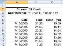
9 Huge Amounts of Data Already Exist Western stream temperature sites >200,000,000 hourly records >20,000 unique stream sites >100 agencies


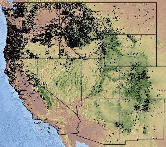
10 BIG FISH Datasets >20,000 fish sample sites


11 BIG BIRD Datasets USGS BISON (Biodiversity Information Serving our Nation) 260,000,000 species occurrence records


12 Data Database Data Aggregation QA/QC Data Cleaning Metadata & digital archiving in user-friendly formats Data table structures & summaries


13 22 Summer Mean Air (C) Status Databases Enable Efficient Queries, Summaries & Analyses Status & Trend Assessments Time Analysis Spatially Continuous Resource Maps More data, monitoring design

14 Creating & Maintaining Big Databases Are Full-Time Jobs for Technical Teams


15 Technology = Force Multiplier Accurate models translated to Real-World Coordinates Climate models Remote Sensing Visualization GIS & Computing Capacity Miniature sensors Nationally Geospatial Frameworks Spatial analyses - DEMs


16 Technology = Force Multiplier Information Dissemination & User-Communities Geospatial data chat & BLOGs Workshops Publication Digitalmedia Webpages Conservation Plans


 >45,000 web-visits/year &")

17 Custom Websites are Key for Data Delivery & Fostering User-Communities (GIS data, software, maps, manuscripts, species occurrences, etc.) >45,000 web-visits/year & rapidly growing user communities Number of Annual Website Visits


18 Real Fish-World Examples Climate Boogeyman Recreational Fisheries High Water Temperature In Grande Ronde Kills 239 Adult Spring Chinook Columbia Basin Bulletin, August 14, 2009 (PST) $30 Billion on Fish & Wildlife Recovery Efforts in PNW Since 1980 Land Use & Water Development ESA Listed Species


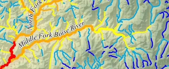
19 Need: High-Resolution Stream Scenarios Global climate models Resolution: 1000 s of kilometers Regional patterns Resolution: 100 s of kilometers River network temperature & flow VIC Stream reach


20 Aggregate Data High-resolution Climate Scenarios Funding agencies: 1-km resolution ~400,000 perennial stream kilometers


21 Database & Scenarios Create Synergies Regulatory temperature standards Too Hot! Too cold! Data access accelerates temperature research Coordinated Interagency monitoring Species distribution models & climate assessments

22 Frequency of Occurrence Climate Vulnerability Varies by Species BIG FISH Data NorWeST Stream Temperature Isaak et al Big biology meets microclimatology. Ecol. Apps. doi: /eap.1501


23 Precise Distribution Models for Sensitive Native Trout Species BIG FISH DATA Predictive Logistic Regression Models Occurrence probability maps Isaak et al The cold-water climate shield: Delineating refugia for preserving native trout through the 21 st Century. Global Change Biology 21:
24 Models Yield Ecological Understanding Differences in Habitat Size Requirements


25 Bull Trout Probability Map 2000s Stream population scale predictions 5,332 >0.1 habitats 1,325 >0.5 habitats 348 >0.9 habitats
26 Bull Trout Probability Map 2040s 3,304 >0.1 habitats 641 >0.5 habitats 130 >0.9 habitats

27 Bull Trout Probability Map 2080s North Cascades Walla Walla Flathead Extreme scenario! +5 C Metolius Central Idaho Extinction not Likely 2,712 >0.1 habitats 460 >0.5 habitats 62 >0.9 habitats
28 Cutthroat Probability Map 2000s 9,219 >0.1 habitats 8,519 >0.5 habitats 3,089 >0.9 habitats
29 Cutthroat Probability Map 2040s 7,914 >0.1 habitats 7,153 >0.5 habitats 2,179 >0.9 habitats

30 Cutthroat Probability Map 2080s 6,489 >0.1 habitats 5,181 >0.5 habitats 1,559 >0.9 habitats


31 Website Provides Information in User-Friendly Digital Formats Just Google Climate shield trout Presentations & Publications Digital Maps & ArcGIS Shapefiles Fish Data Sources Distribution Monitoring File formats: ArcGIS files pdf files 15 Scenarios: 3 climate periods 5 Brook invasion levels


32 Precise Spatial Information about Refugia Empowers Local Decision Makers See both the Forest & the Trees! Highest priority conservation investment!


33 Precise Spatial Information also Guides Efficient Data Collection & Monitoring There are only ~5,332 potential bull trout habitats Why not census them all?

34 Uber Efficiency has Arrived: Rangewide edna Bull Trout Project Funded by: Partners sampled 2016: 3,000 stream sites 2017: 4,000 more site surveys planned 2018: 3,000 final site surveys Sample sites are already organized in a database!


35 Dynamic Web-data portal Delivers Results at Website Query & download data by site, stream, HUC, DSP, species range


36 edna ByCatch is Important BiProduct An Aquatic Biodiversity Archive


37 Aquatic ednatlas Project: An Open-Access Database for all Species in the American West + National Genomics Center for Wildlife & Fish Conservation Partners have sampled >7,000 sites already


38 Goal: Precise Models & Databases for All Species High-resolution landscape models I m going to invest here instead of here


39 Management Decisions Inter-Agency Databases Engage Everyone & Strengthen Conservation Networks GCM Landscape/ Network Coordinated Management & Conservation Data Collected by Local Bios & Hydros


40 Better Inter-Agency Information Enables Efficiency on Many Fronts Urbanization & Population Growth Habitat degradation Climate Change


41 Climate Refugia put us on a Path to Preserve More Cool Critters in the Long-run
A New Class of Spatial Statistical Model for Data on Stream Networks: Overview and Applications
 A New Class of Spatial Statistical Model for Data on Stream Networks: Overview and Applications Jay Ver Hoef Erin Peterson Dan Isaak Spatial Statistical Models for Stream Networks Examples of Autocorrelated
Empowered lives. Resilient nations. Data for People and Planet. powered by
 Empowered lives. Resilient nations. Data for People and Planet powered by Overview As we enter the fourth industrial revolution, technology is revolutionizing our ability to map nature. Satellite data
Geography for the 2020 Round of Census
 Boundaries Key Census Data EA Id Population Male Female EA Id Area EA Id Num HH Avg HH size Geography for the 2020 Round of Census Linda Peters, Esri lpeters@esri.com Integration of Statistical and Geospatial
Overview. Project Background Project Approach: Content and Application Development Application Demonstration Future Developments
 Overview Project Background Project Approach: Content and Application Development Application Demonstration Future Developments Southeast Pressures: Continued Population Growth Transportation Corridors
Key Points Sharing fosters participation and collaboration Metadata has a big role in sharing Sharing is not always easy
 Sharing Resources Geoff Mortson esri, Inc. SDI Solutions Team Key Points Sharing fosters participation and collaboration Metadata has a big role in sharing Sharing is not always easy Data Sharing is Good
USGS National Geospatial Program Understanding User Needs. Dick Vraga National Map Liaison for Federal Agencies July 2015
 + USGS National Geospatial Program Understanding User Needs Dick Vraga National Map Liaison for Federal Agencies July 2015 + Topics 2 Background Communities of Use User Surveys National Map Liaisons Partnerships
Realizing benefits of Spatial Data Infrastructure A user s perspective from Environment Agency - Abu Dhabi
 Realizing benefits of Spatial Data Infrastructure A user s perspective from Environment Agency - Abu Dhabi Anil Kumar Director, Environment Information Management 26 April 2012 Geospatial World Forum,
Spatial Data Availability Energizes Florida s Citizens
 NASCIO 2016 Recognition Awards Nomination Spatial Data Availability Energizes Florida s Citizens State of Florida Agency for State Technology & Department of Environmental Protection Category: ICT Innovations
A Comprehensive Inventory of the Number of Modified Stream Channels in the State of Minnesota. Data, Information and Knowledge Management.
 A Comprehensive Inventory of the Number of Modified Stream Channels in the State of Minnesota Data, Information and Knowledge Management Glenn Skuta Environmental Analysis and Outcomes Division Minnesota
NorWeST Stream Temperature Model: Data Structure, Covariates, & Applications
 NorWeST Stream Temperature Model: Data Structure, Covariates, & Applications Dan Isaak, Seth Wenger 1, Erin Peterson 2, Jay Ver Hoef 3 Charlie Luce, Steve Hostetler 4, Jason Dunham 4, Jeff Kershner 4,
Pictometry GIS and Integration Solutions. Presented by Peter White, GISP GIS Product Manager, Pictometry International Corp.
 Pictometry GIS and Integration Solutions Presented by Peter White, GISP GIS Product Manager, Pictometry International Corp. 1. Pictometry Web Integration Solutions 2. Advanced LiDAR Sensor and Solutions
Mobrand to Jones and Stokes. Sustainable Fisheries Management Use of EDT
 Sustainable Fisheries Management Use of EDT Ecosystem Diagnosis and Treatment EDT EDT designed to provide a practical, science-based approach for developing and implementing watershed plans. Provides decision
Using Landscape Analysis Metrics to Manage Aquatic Invasive Species and Targeted Transboundary Species in the Crown of the Continent Ecosystem
 Using Landscape Analysis Metrics to Manage Aquatic Invasive Species and Targeted Transboundary Species in the Crown of the Continent Ecosystem Project Coordinator: Erin Seton, Crown Managers Partnership
Introduction. Elevation Data Strategy. Status and Next Steps
 1 2 Introduction Elevation Data Strategy Status and Next Steps 3 Canada is the 2nd largest country in the world - 9.9 million sq km Surrounded by 3 oceans with 202 000 km of coastline Population over 35
Alaska Center for Climate Assessment and Policy
 Alaska Center for Climate Assessment and Policy Welcome to the webinar: CONNECTING ALASKA LANDSCAPES INTO THE FUTURE December 8, 2009 10 AM (ADT) By Nancy Fresco, Scenarios Network for Alaska Planning
EnviroAtlas: An Atlas about Ecosystems and their Connection with People
 EnviroAtlas: An Atlas about Ecosystems and their Connection with People Annie Neale, Megan Mehaffey & Atlas Team ASWM Webinar October, 17 th, 2012 What is it? The Atlas is an online decision support tool
Oregon Dept. of Fish & Wildlife Aquatic Inventories Project State of Oregon Fish Sampling Coverage Metadata Date: August, 2002
 Oregon Dept. of Fish & Wildlife Aquatic Inventories Project State of Oregon Fish Sampling Coverage Metadata Date: August, 2002 General Dataset Documentation: Contact Person: Kim Jones Project Leader ODFW
An Introduction to Day Two. Linking Conservation and Transportation Planning Lakewood, Colorado August 15-16, 16, 2006
 An Introduction to Day Two Linking Conservation and Transportation Planning Lakewood, Colorado August 15-16, 16, 2006 1 Agenda Day One Transportation Planning Heritage Program State Wildlife Action Plan
Modeling Fish Assemblages in Stream Networks Representation of Stream Network Introduction habitat attributes Criteria for Success
 Modeling Fish Assemblages in Stream Networks Joan P. Baker and Denis White Western Ecology Division National Health & Environmental Effects Research Laboratory U.S. Environmental Protection Agency baker.joan@epa.gov
Canadian Historical GIS Partnership Development: Taking Steps for Historical Mapping in Canada
 Canadian Historical GIS Partnership Development: Taking Steps for Historical Mapping in Canada Byron Moldofsky Manager, GIS and Cartography Office Department of Geography and Planning University of Toronto
StreamStats: Delivering Streamflow Information to the Public. By Kernell Ries
 StreamStats: Delivering Streamflow Information to the Public By Kernell Ries U.S. Department of the Interior U.S. Geological Survey MD-DE-DC District 410-238-4317 kries@usgs.gov StreamStats Web Application
FESTF Gopher. A Data Integration Tool to Inform Decisions in FIFRA/ESA Processes
 FESTF Gopher A Data Integration Tool to Inform Decisions in FIFRA/ESA Processes April 26, 2018 CropLife America & RISE Regulatory Conference Arlington, VA An Introduction to FESTF The (FESTF), incorporated
The Arctic Landscape Conservation Cooperative Conservation Goals
 The Arctic Landscape Conservation Cooperative Conservation Goals Adopted by the Arctic LCC Steering Committee, 24 August 2010 Background : Landscape Conservation Cooperatives and Climate Science Centers
Crown of the Continent Landscape Analysis/Ecological Indicators Project
 Crown of the Continent Landscape Analysis/Ecological Indicators Project Project Coordinator: Erin Sexton, Crown Managers Partnership (CMP), Flathead Lake Biological Station, University of Montana; (406)
This Powerpoint presentation summarizes the use of NetMap for a Fire Decision Support System. Created on Sept 25, 2015 by Dr. Lee Benda and Kevin
 This Powerpoint presentation summarizes the use of NetMap for a Fire Decision Support System. Created on Sept 25, 2015 by Dr. Lee Benda and Kevin Andras (TerrainWorks). 1 The general approach strategy:
Kyoto and Carbon Initiative - the Ramsar / Wetlands International perspective
 Kyoto and Carbon Initiative - the Ramsar / Wetlands International perspective (the thoughts of Max Finlayson, as interpreted by John Lowry) Broad Requirements Guideline(s) for delineating wetlands (specifically,
Project Primary Contact: Gregg Servheen, Idaho Department of Fish and Game, PO Box 25 Boise, ID ,
 Project Title: Idaho Montana Divide Project Objective: Pilot the conceptualization and coordination of a transboundary Decision Support System(DSS) for fish, wildlife, and habitats along the Idaho Montana
Land Use Methods & Metrics Development Outcome
 Quarterly Progress Meeting November 15, 2018 Land Use Methods & Metrics Development Outcome Peter Claggett, USGS LUWG Coordinator Through the Chesapeake Bay Watershed Agreement, the Chesapeake Bay Program
USGS Hydrography Overview. May 9, 2018
 + 1 USGS Hydrography Overview May 9, 2018 + 2 The National Geospatial Program Provides the geospatial baseline of the Nation s topography, natural landscape and built environment through The National Map,
Land Accounts - The Canadian Experience
 Land Accounts - The Canadian Experience Development of a Geospatial database to measure the effect of human activity on the environment Who is doing Land Accounts Statistics Canada (national) Component
GIS Data, Technology, and Models. to Integrate Information and Improve Transportation Decision-Making. within the Eco-Logical* Framework for Oregon
 GIS Data, Technology, and Models to Integrate Information and Improve Transportation Decision-Making within the Eco-Logical* Framework for Oregon GIS-T 2009, Oklahoma City, OK April 8, 2009, Session 5..2.2
Welcome to NetMap Portal Tutorial
 Welcome to NetMap Portal Tutorial Potential Applications What Can you do with the Portal? At least 25 things! 1) Locate the best potential fish habitats. 2) Identify biological hotspots. 3) Map floodplain
EBA Engineering Consultants Ltd. Creating and Delivering Better Solutions
 EBA Engineering Consultants Ltd. Creating and Delivering Better Solutions ENHANCING THE CAPABILITY OF ECOSYSTEM MAPPING TO SUPPORT ADAPTIVE FOREST MANAGEMENT Prepared by: EBA ENGINEERING CONSULTANTS LTD.
SUPPORTS SUSTAINABLE GROWTH
 DDSS BBUUN NDDLLEE G E O S P AT I A L G O V E R N A N C E P A C K A G E SUPPORTS SUSTAINABLE GROWTH www.digitalglobe.com BRISBANE, AUSTRALIA WORLDVIEW-3 30 CM International Civil Government Programs US
Summary Description Municipality of Anchorage. Anchorage Coastal Resource Atlas Project
 Summary Description Municipality of Anchorage Anchorage Coastal Resource Atlas Project By: Thede Tobish, MOA Planner; and Charlie Barnwell, MOA GIS Manager Introduction Local governments often struggle
Application of GIS Technology in Watershed-based Management and Decision Making
 Application of GIS Technology in Watershed-based Management and Decision Making U. Sunday Tim Iowa State University Department of Agricultural and Biosystems Engineering 100 Davidson Hall Email:
Mapping the Distributions of the. America: Data and Tools
 Mapping the Distributions of the Freshwater Fishes of North America: Data and Tools Comparing Apples,Oranges and Pineapples: Mapping the distribution of brook trout; Lessons learned from the Eastern Brook
Landscape Planning and Habitat Metrics
 Landscape Planning and Habitat Metrics Frank W. Davis National Center for Ecological Analysis and Synthesis UC Santa Barbara (Tools for Landscape Biodiversity Planning) Jimmy Kagan Institute for Natural
GEOGRAPHIC INFORMATION SYSTEMS Session 8
 GEOGRAPHIC INFORMATION SYSTEMS Session 8 Introduction Geography underpins all activities associated with a census Census geography is essential to plan and manage fieldwork as well as to report results
GIS in Weather and Society
 GIS in Weather and Society Olga Wilhelmi Institute for the Study of Society and Environment National Center for Atmospheric Research WAS*IS November 8, 2005 Boulder, Colorado Presentation Outline GIS basic
Chesapeake Bay Program s New Land Cover Map (and some other neat stuff)
") Chesapeake Bay Program s New Land Cover Map (and some other neat stuff) Cassandra Pallai Geospatial Project Manager Chesapeake Conservancy December 6, 2016 Potomac Watershed Partnership Chesapeake Conservancy
Chesapeake Bay Program s New Land Cover Map (and some other neat stuff) Cassandra Pallai Geospatial Project Manager Chesapeake Conservancy December 6, 2016 Potomac Watershed Partnership Chesapeake Conservancy
Brian D. George. GIMS Specialist Ohio Coastal Atlas Project Coordinator and Cartographer. Impacts and Outcomes of Mature Coastal Web Atlases
 Ohio Coastal Atlas Project Brian D. George GIMS Specialist Ohio Coastal Atlas Project Coordinator and Cartographer Ohio Department of Natural Resources Office of Coastal Management Sandusky, OH Impacts
CLIMATE CHANGE ADAPTATION BY MEANS OF PUBLIC PRIVATE PARTNERSHIP TO ESTABLISH EARLY WARNING SYSTEM
 CLIMATE CHANGE ADAPTATION BY MEANS OF PUBLIC PRIVATE PARTNERSHIP TO ESTABLISH EARLY WARNING SYSTEM By: Dr Mamadou Lamine BAH, National Director Direction Nationale de la Meteorologie (DNM), Guinea President,
Virginia Shoreline Mapping Tools
 Virginia Shoreline Mapping Tools December 15, 2017 Karen Duhring Center for Coastal Resources Management Virginia Institute of Marine Science College of William & Mary Virginia Shoreline Mapping Tools
Lower South Fork McKenzie River Floodplain Enhancement Project
 Lower South Fork McKenzie River Floodplain Enhancement Project McKenzie River Ranger District Willamette National Forest Project Location The project is located in the South Fork McKenzie River Watershed,
Ministry of Health and Long-Term Care Geographic Information System (GIS) Strategy An Overview of the Strategy Implementation Plan November 2009
 Strategy An Overview of the Strategy Implementation Plan November 2009") Ministry of Health and Long-Term Care Geographic Information System (GIS) Strategy An Overview of the Strategy Implementation Plan November 2009 John Hill, Health Analytics Branch Health System Information
Ministry of Health and Long-Term Care Geographic Information System (GIS) Strategy An Overview of the Strategy Implementation Plan November 2009 John Hill, Health Analytics Branch Health System Information
Data Aggregation with InfraWorks and ArcGIS for Visualization, Analysis, and Planning
 Data Aggregation with InfraWorks and ArcGIS for Visualization, Analysis, and Planning Stephen Brockwell President, Brockwell IT Consulting, Inc. Join the conversation #AU2017 KEYWORD Class Summary Silos
Data Aggregation with InfraWorks and ArcGIS for Visualization, Analysis, and Planning
 CI125230 Data Aggregation with InfraWorks and ArcGIS for Visualization, Analysis, and Planning Stephen Brockwell Brockwell IT Consulting Inc. Sean Kinahan Brockwell IT Consulting Inc. Learning Objectives
Fig 1. Steps in the EcoValue Project
 Assessing the Social and Economic Value of Ecosystem Services in the Northern Forest Region: A Geographic Information System (GIS) Approach to Landscape Valuation Principal Investigator(s): Dr. Matthew
Pan-Arctic Digital Elevation Map (Pan-Arctic DEM)
") Memorandum to CAFF Board 07/28/2017 BACKGROUND: Pan-Arctic Digital Elevation Map (Pan-Arctic DEM) ArcticDEM is a National Geospatial-Intelligence Agency (NGA)-National Science Foundation (NSF) publicprivate
Memorandum to CAFF Board 07/28/2017 BACKGROUND: Pan-Arctic Digital Elevation Map (Pan-Arctic DEM) ArcticDEM is a National Geospatial-Intelligence Agency (NGA)-National Science Foundation (NSF) publicprivate
Climate Change in Newfoundland & Labrador
 Climate Change in Newfoundland & Labrador Impacts and Adaptation Newleef Conference 08 October 2015 Met-Ocean Services The Team 55 personnel; 24/7 operational weather forecast desk; Equipment technician
September 2016 New ArcGIS Solutions
 September 2016 New ArcGIS Solutions Hydroelectric https://profservices.maps.arcgis.com/apps/mapjournal/index.html?appid=0ef98f74f8fb4f9da88 1adc521e1c90f Adopta Engage the public in the maintenance and
Louisiana Transportation Engineering Conference. Monday, February 12, 2007
 Louisiana Transportation Engineering Conference Monday, February 12, 2007 Agenda Project Background Goal of EIS Why Use GIS? What is GIS? How used on this Project Other site selection tools I-69 Corridor
Challenges and Successes in Sharing Geospatial Data in Africa
 Challenges and Successes in Sharing Geospatial Data in Africa 2018 GeoNode Summit Torino, Italy March 26-28, 2018 Bernard Justus Muhwezi Manager, Geo-Information Services Uganda Bureau of Statistics, Kampala,
The Invasion of False Brome in Western Oregon
 The Invasion of False Brome in Western Oregon GIS II Presentation Winter 2006 Will Fellers Kurt Hellerman Kathy Strope Statia Cupit False Brome (Brachypodium sylvaticum) Perennial bunchgrass native to
Water Atlas Overview. Myakka River Management Coordinating Council June 22, 2012 Englewood, Florida
 Water Atlas Overview Myakka River Management Coordinating Council June 22, 2012 Englewood, Florida What is the Water Atlas? A data warehouse A set of interactive maps A collection of tools for viewing/analyzing
Hannah Moore CEE Juvenile Bull Trout Distribution in the South Fork Walla Walla River, Oregon
 Hannah Moore CEE 6440 Juvenile Bull Trout Distribution in the South Fork Walla Walla River, Oregon Introduction Bull trout (Salvelinus confluentus) are an endangered species historically found throughout
The production and use of a hydrographic flow-direction network of surface waters. Rickard HALLENGREN, Håkan OLSSON and Erik SISELL, Sweden
 The production and use of a hydrographic flow-direction network of surface waters Rickard HALLENGREN, Håkan OLSSON and Erik SISELL, Sweden Key words: hydrographic, flow-direction network, surface waters
Gina Hunt Chesapeake Bay Program Fish Habitat Coordinator
 Gina Hunt Chesapeake Bay Program Fish Habitat Coordinator Regional Fish Habitat Assessment User Needs A guiding principal for the assessment framework is that it should support planning and management
CHAPTER 7 PRODUCT USE AND AVAILABILITY
 CHAPTER 7 PRODUCT USE AND AVAILABILITY Julie Prior-Magee Photo from SWReGAP Training Site Image Library Recommended Citation Prior-Magee, J.S. 2007. Product use and availability. Chapter 7 in J.S. Prior-Magee,
Office of Technology Partnerships GIS Collaboration
 Office of Technology Partnerships GIS Collaboration State GIS Update April 21, 2017 Mark Holmes, GISP Outline MGF Upgrade Project Census Programs Imagery Update LiDAR Update Open Discussion 2 MGF Background
1) make sure folks know what s available in terms of geospatial data and resources that could contribute to their decision support toolkits;
 make sure folks know what s available in terms of geospatial data and resources that could contribute to their decision support toolkits;") Introduction 1 2001 It was born out of the recognition that several of the regions prominent resource management agencies have similar, if not shared, requirements for GIS data. Some of the underlying
Introduction 1 2001 It was born out of the recognition that several of the regions prominent resource management agencies have similar, if not shared, requirements for GIS data. Some of the underlying
Land Use in the context of sustainable, smart and inclusive growth
 Land Use in the context of sustainable, smart and inclusive growth François Salgé Ministry of sustainable development France facilitator EUROGI vice president AFIGéO board member 1 Introduction e-content+
Estimating Stream Gradient Using NHD Stream Lines and DEM Data
 Estimating Stream Gradient Using NHD Stream Lines and DEM Data David Nagel, John M. Buffington, and Daniel Isaak U.S. Forest Service, Rocky Mountain Research Station Boise Aquatic Sciences Lab Boise, ID
GRADUATE CERTIFICATE PROGRAM
 GRADUATE CERTIFICATE PROGRAM GEOGRAPHIC INFORMATION SCIENCES Department of Geography University of North Carolina Chapel Hill Conghe Song, Director csong @email.unc.edu 919-843-4764 (voice) 919-962-1537
THE NATURESERVE NETWORK
 THE NATURESERVE NETWORK Access to NatureServe's best available data on the locations of endangered species September 1, 2011 A Network Connecting Science with Conservation Mexico Guatemala El Salvador
Capturing a Holistic Understanding of a Large Marine Ecosystem The NOAA Gulf of Mexico Data Atlas
 Capturing a Holistic Understanding of a Large Marine Ecosystem The NOAA Gulf of Mexico Data Atlas NODC / National Coastal Data Development Center gulfalas.noaa.gov Need: data that contribute to long-term
Regional Flash Flood Guidance and Early Warning System
 WMO Training for Trainers Workshop on Integrated approach to flash flood and flood risk management 24-28 October 2010 Kathmandu, Nepal Regional Flash Flood Guidance and Early Warning System Dr. W. E. Grabs
ArcGIS Platform For NSOs
 ArcGIS Platform For NSOs Applying GIS and Spatial Thinking to Official Statistics Esri UC 2014 Demo Theater Applying GIS at the NSO Generic Statistical Business Process Model (GSBPM) 1 Specify Needs 2
What's New with NHDPlus (Classic)?
?") What's New with NHDPlus (Classic)? 1987 Reach File Version 1 2017 - NHDPlus Annie Mejaes EPA, Office of Water 2 Overview NHD-NHDPlus Basics Evolving NHD-NHDPlus Data and Tools Training and Support The
What's New with NHDPlus (Classic)? 1987 Reach File Version 1 2017 - NHDPlus Annie Mejaes EPA, Office of Water 2 Overview NHD-NHDPlus Basics Evolving NHD-NHDPlus Data and Tools Training and Support The
Getting On the Same Page and Parcel
 Getting On the Same Page and Parcel Local flair is a valued and cherished quality of small Vermont towns and cities. The Agency of Natural Resources works daily with town officials and local committee
Disaster Management & Recovery Framework: The Surveyors Response
 Disaster Management & Recovery Framework: The Surveyors Response Greg Scott Inter-Regional Advisor Global Geospatial Information Management United Nations Statistics Division Department of Economic and
TOWARDS CLIMATE-RESILIENT COASTAL MANAGEMENT: OPPORTUNITIES FOR IMPROVED ICZM IN BELIZE
 TOWARDS CLIMATE-RESILIENT COASTAL MANAGEMENT: OPPORTUNITIES FOR IMPROVED ICZM IN BELIZE CHANTALLE SAMUELS Coastal Zone Management Authority and Institute The Caribbean Community Climate Change Centre VULNERABILITY
Environmentally-induced Population Displacements: Conclusions from PERN s Online Seminar
 Environment, Forced Migration & Social Vulnerability International Conference 9-11 October 2008 Bonn, Germany www.efmsv2008.org Environmentally-induced Population Displacements: Conclusions from PERN s
Kootenai River Habitat Restoration Program Update
 Kootenai River Habitat Restoration Program Update Kootenai Tribe of Idaho Kootenai Valley Resource Initiative November 19, 2012 Bonners Ferry, Idaho Changes to Kootenai Basin Beaver trapping Floodplain
Introduction of the Asia-Oceania Global Earth Observation System of Systems (AOGEOSS) GEO Initiative(GI-22 )
 GEO Initiative(GI-22 )") Introduction of the Asia-Oceania Global Earth Observation System of Systems (AOGEOSS) GEO Initiative(GI-22 ) Prof. Xiang ZHOU Institute of Remote Sensing and Digital Earth, CAS 11 May 2017 Kunming, China
Introduction of the Asia-Oceania Global Earth Observation System of Systems (AOGEOSS) GEO Initiative(GI-22 ) Prof. Xiang ZHOU Institute of Remote Sensing and Digital Earth, CAS 11 May 2017 Kunming, China
Compact guides GISCO. Geographic information system of the Commission
 Compact guides GISCO Geographic information system of the Commission What is GISCO? GISCO, the Geographic Information System of the COmmission, is a permanent service of Eurostat that fulfils the requirements
ISU GIS CENTER S ARCSDE USER'S GUIDE AND DATA CATALOG
 ISU GIS CENTER S ARCSDE USER'S GUIDE AND DATA CATALOG 2 TABLE OF CONTENTS 1) INTRODUCTION TO ARCSDE............. 3 2) CONNECTING TO ARCSDE.............. 5 3) ARCSDE LAYERS...................... 9 4) LAYER
EcoServ-GIS. Ecosystem Services Mapping: A Wildlife Trust GIS Toolkit to map ecosystem services at a county scale
 EcoServ-GIS Ecosystem Services Mapping: A Wildlife Trust GIS Toolkit to map ecosystem services at a county scale Dr Jonathan Winn Living Landscape Coordinator Durham Wildlife Trust Dr Chloe Bellamy Ecosystem
Priority areas for grizzly bear conservation in western North America: an analysis of habitat and population viability INTRODUCTION METHODS
 Priority areas for grizzly bear conservation in western North America: an analysis of habitat and population viability. Carroll, C. 2005. Klamath Center for Conservation Research, Orleans, CA. Revised
E.W. Johnson 1 and M. Plivelich 2
 E.W. Johnson 1 and M. Plivelich 2 Summary A regionalized approach is being established for the collaborative stewardship of the National Hydrography Dataset (NHD) by state, federal, and university partners
Geospatial Big Data Analytics for Road Network Safety Management
 Proceedings of the 2018 World Transport Convention Beijing, China, June 18-21, 2018 Geospatial Big Data Analytics for Road Network Safety Management ABSTRACT Wei Liu GHD Level 1, 103 Tristram Street, Hamilton,
The Challenge of Geospatial Big Data Analysis
 288 POSTERS The Challenge of Geospatial Big Data Analysis Authors - Teerayut Horanont, University of Tokyo, Japan - Apichon Witayangkurn, University of Tokyo, Japan - Shibasaki Ryosuke, University of Tokyo,
Introduction to Part III Examining wildlife distributions and abundance using boat surveys
 Baseline Wildlife Studies in Atlantic Waters Offshore of Maryland: Final Report to the Maryland Department of Natural Resources and Maryland Energy Administration, 2015 Introduction to Part III Examining
National Hydrography Dataset (NHD) Update Project for US Forest Service Region 3
 Update Project for US Forest Service Region 3") National Hydrography Dataset (NHD) Update Project for US Forest Service Region 3 Allison Moncada California State University, Northridge February 2017 July 2017 Advisor: Joel Osuna Center for Geographical
National Hydrography Dataset (NHD) Update Project for US Forest Service Region 3 Allison Moncada California State University, Northridge February 2017 July 2017 Advisor: Joel Osuna Center for Geographical
EcoServ-GIS. EcoServ GIS Stage I. Why EcoServ GIS? 17/12/2012
 EcoServ-GIS Ecosystem Services Mapping: A Wildlife Trust GIS Toolkit to map ecosystem services at a county scale Dr Jonathan Winn Living Landscape Coordinator Durham Wildlife Trust Dr Chloe Bellamy Ecosystem
Economic Benefit Study on Value of Spatial Information Australian Experience
 Economic Benefit Study on Value of Spatial Information Australian Experience Dr Zaffar Sadiq Mohamed-Ghouse Director, International Relations Cooperative Research Centre for Spatial Information zsadiq@crcsi.com.au
NatureServe s Federally Listed Species Location Data Play an Important Role in EPA s FIFRA Risk Assessments
 NatureServe s Federally Listed Species Location Data Play an Important Role in EPA s FIFRA Risk Assessments 1 ASHLEA FRANK COMPLIANCE SERVICES INTERNATIONAL FIFRA ENDANGERED SPECIES TASK FORCE BIODIVERSITY
The Atlas Aspect of the Atlas of Living Australia
 The Atlas Aspect of the Atlas of Living Australia Lee Belbin lee@blatantfabrications.com Melbourne Museum, July 28, 2010 The Atlas is funded by the Australian Government under the National Collaborative
INDONESIA S S UPDATE: GEOSPATIAL INFORMATION FOR SUSTAINABLE DEVELOPMENT RELATED TO INA SDI Dr. Asep Karsidi, M.Sc
 INDONESIA S S UPDATE: GEOSPATIAL INFORMATION FOR SUSTAINABLE DEVELOPMENT RELATED TO INA SDI Dr. Asep Karsidi, M.Sc GEOSPATIAL INFORMATION AGENCY 08 August, 2012 OUTLINE 1. Transformation Bakosurtanal into
Roles of NGII in successful disaster management
 The Second UN-GGIM-AP Plenary Meeting Roles of NGII in successful disaster management Republic of Korea Teheran Iran 28 October 2013 Sanghoon Lee, Ph.D. NGII Outline Type of Disasters Occur in Korea Practical
NOACA s DART: Web GIS Tools for Transportation Planning. Chad Harris, NOACA Bryan Baker, Tierra Plan LLC Kevin Knapp, Tierra Plan LLC
 NOACA s DART: Web GIS Tools for Transportation Planning Chad Harris, NOACA Bryan Baker, Tierra Plan LLC Kevin Knapp, Tierra Plan LLC NOACA DART: Data Analysis and Reporting Tool NOACA: Northeast Ohio Areawide
The National Integrated Drought Information System (NIDIS) Moving the Nation from Reactive to Proactive Drought Risk Management
 Moving the Nation from Reactive to Proactive Drought Risk Management") The National Integrated Drought Information System (NIDIS) Moving the Nation from Reactive to Proactive Drought Risk Management CSG-West Annual Meeting Agriculture & Water Committee Snowbird, UT September
The National Integrated Drought Information System (NIDIS) Moving the Nation from Reactive to Proactive Drought Risk Management CSG-West Annual Meeting Agriculture & Water Committee Snowbird, UT September
Blue Mountain Province
 Rolling Provincial Review: Implementation 2001-2003 Province 23 Columbia Basin Fish & Wildlife Authority Province FY 2001-2003 Spending Summaries NPCC Recommendations and BPA Spending by Project Category,
On the Feasibility of Quantitative Population Viability Analysis in Recovery Planning: Efforts to Bridge the Gap Between Theory and Practice
 On the Feasibility of Quantitative Population Viability Analysis in Recovery Planning: Efforts to Bridge the Gap Between Theory and Practice LUTZ TISCHENDORF 1 AND KATHRYN LINDSAY 2 1 ELUTIS Modeling and
Introducing Spatial IQ
 Introducing Spatial IQ TM A Managed Services Approach to Enterprise GIS Let AppGeo be your bridge to the future. The Magic of Location AppGeo believes that information plus geography changes how we work
Enabling Access to Arctic Location Based Information - the Arctic SDI
 Enabling Access to Arctic Location Based Information - the Arctic SDI Jani Kylmäaho Head of Arctic SDI Geoportal WG National Land Survey of Finland SAO Chair, WG Chairs and Executive Secretaries meeting
June 19 Huntsville, Alabama 1
 June 19 Huntsville, Alabama 1 Real-Time Geospatial Data: The Fusion of PI and ArcGIS Enabling Smarter Facilities Management OSIsoft and Esri Mapping and Location Analytics Platform Supporting Your Use
Educational Qualification No ( No of Positions) 01. Geographic
 01. Geographic") ICZMP, State Project Management Unit-Orissa Plot # 108,Unit VII, Suryanagar,Bhubaneswar 751 003 ICZMP invites applications from eligible candidates for filling up of posts as mentioned below under the
ICZMP, State Project Management Unit-Orissa Plot # 108,Unit VII, Suryanagar,Bhubaneswar 751 003 ICZMP invites applications from eligible candidates for filling up of posts as mentioned below under the
Framework on reducing diffuse pollution from agriculture perspectives from catchment managers
 Framework on reducing diffuse pollution from agriculture perspectives from catchment managers Photo: River Eden catchment, Sim Reaney, Durham University Introduction This framework has arisen from a series