The CUAHSI Hydrologic Information System
|
|
|
- Beatrix Powell
- 5 years ago
- Views:
Transcription

1 The CUAHSI Hydrologic Information System Presented by Dr. Tim Whiteaker The University of Texas at Austin 18 November, 2010 Session T1B


2 About the Speaker PhD 2004 Research Associate
3 What You Will Learn What is the CUAHSI Hydrologic Information System (HIS) History Why people use it How to access data in HIS How to publish your data with HIS


4 Outline The HIS Story HIS components Putting the pieces together
5 Outline The HIS Story HIS components Putting the pieces together
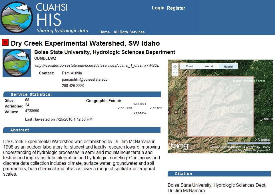
6 HIS Connects People with Data The CUAHSI* Hydrologic Information System (HIS) provides web services, tools, standards and procedures that enhance access to more and better data for hydrologic analysis. his.cuahsi.org *Consortium of Universities for the Advancement of Hydrologic Science, Inc.


7 Niagara Peninsula Decision Support

8

9


10
11 What is CUAHSI Consortium of Universities for the Advancement of Hydrologic Science, Inc Formed in 2001 Develops infrastructure and services to advance hydrologic science in US universities Earth Sciences Atmospheric Sciences Ocean Sciences CUAHSI HIS National Science Foundation Geosciences Directorate

12 CUAHSI Member Institutions 112 North American universities, and 16 international affiliates

13 CUAHSI Hydrologic Information Systems Project David R. Maidment The University of Texas at Austin (HIS Project Leader)
14 CUAHSI HIS Development 2000 CUAHSI Regional Meetings HIS Pilot Project HIS Development Project


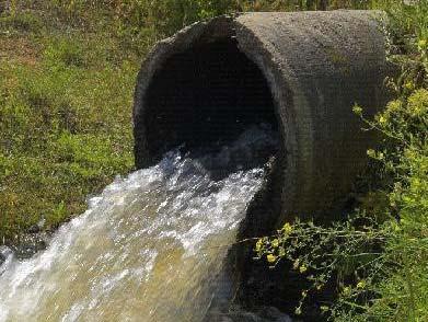

15 too much water dirty water too little water water environment

16 Please rank these four HIS service categories for helping you. Conclusion: Data services are the highest priority

17 Which of the following data analysis difficulties are most important for HIS to address? Priorities are: Data formats Metadata
18 Data Integration Hydrologic Observations GIS Data Digital Watershed Weather and Climate Remote Sensing Currently, the focus is on data from monitoring sites at point locations.
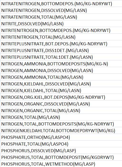
19 The Result WaterML language for describing water data WaterML Standards National catalog of water data sources Metadata Catalog Services Free software for data access Software
20 Metadata Catalog, October public services 18,000+ variables million sites 23.3 million series Referencing 5.1 billion data values Map integrating NWIS, STORET, & Climatic Sites
21 Streamflow 2 services 7 variables 4,363 sites 11,484 series 9,493,968 records

22 Salinity 5 services 7 variables 6,613 sites 7,912 series 346,813 records
23 Water Temperature 6 services 11 variables 11,158 sites 22,953 series 1,546,841 records
24 Dissolved Oxygen 5 services 18 variables 10,823 sites 21,655 series 930,571 records

25 Bacteria 1 service 21 variables 4,801 sites 15,483 series 297,849 records
26 Nutrients 1 service 25 variables 5,635 sites 52,396 series 856,194 records
27 3 services 7 variables 6,228 sites 16,576 series 785,650 records

28 For more on the HIS Story his.cuahsi.org
29 Outline The HIS Story HIS components Putting the pieces together
30 Web Paradigm Catalog (Google) Catalog harvest Search Web Server (CNN.com) Access Browser (Firefox)
31 Services Oriented Architecture for Water Data HIS Central Service registration Catalog harvest Search HydroServer Data access HydroDesktop
32 HIS System Overview USGS Dat a University Web Service Data Registration HIS Central HIS Central Metadata Catalog Hydrologic Ontology Dat a HydroServers Data Access Data Discovery Users (HydroDesktop)


33 Water quantity and quality Water Data Soil water Rainfall & Snow Remote sensing Meteorology Modeling
34 Point Observations Time Series A point location in space A series of values in time

35 Sources of Observations Data

")


36 Getting Water Data (the old way) Different Query Pages Different Query Responses

37 WaterML as a Standard Format Streamflow data in WaterML language Discharge of the San Marcos River at Luling, June 28 July 18, 2002


38 WaterML includes location, variables, and time series location variable time series


39 Web Pages and Web Services Uses Hypertext Markup Language (HTML) Uses WaterML (a Markup Language for water data)
40 Point Observations Information Model Utah State Univ Data Source Little Bear River Network WaterOneFlow Service Little Bear River at Mendon Rd Sites GetSites GetSiteInfo Dissolved Oxygen Variables 9.78 mg/l, 1 October 2007, 5PM Values {Value, Time, Metadata} A data source operates an observation network A network is a set of observation sites A site is a point location where one or more variables are measured A variable is a property describing the flow or quality of water A value is an observation of a variable at a particular time Metadata provide additional information about the value GetVariableInfo GetValues


41 WaterOneFlow Set of query functions Returns data in WaterML
42 WaterML and WaterOneFlow Locations Variables Date Ranges Client LOAD GetSites GetSiteInfo GetVariableInfo GetValues WaterML WaterOneFlow Web Service TRANSFORM USGS Data Data EPA UT Data Data Repositories EXTRACT WaterML is an XML language for communicating water data WaterOneFlow is a set of web services based on WaterML
43 HIS System HydroServer USGS Dat a University Web Service Data Registration HIS Central HIS Central Metadata Catalog Hydrologic Ontology Dat a HydroServers Data Access Data Discovery And Access Users
44 HydroServer Goals A platform for publishing space time hydrologic datasets that: Provides local control of data Makes data universally available Is open source (hydroserver.codeplex.com)


45 Ongoing Data Collection Point Observations Data Internet Applications Historical Data Files ODM Database GIS Data GetSites GetSiteInfo GetVariableInfo GetValues WaterML WaterOneFlow Web Service HydroServer Data presentation, visualization, and analysis through Internet enabled applications


46 ICEWATER A Regional HIS ICEWATER INRA Constellation of Experimental WATERsheds Coalition of 8 universities Point Observations Stream gages Water quality sampling Weather stations Soil moisture Snow monitoring Groundwater level/quality Spatially Distributed Data Land use/cover Terrain Hydrography AK WA OR CA NV I D UT AZ MT W Y CO NM


47 Operational HydroServers


ftp DB DB DB Files KISTERS")
48 HydroServer Alternatives KISTERS External Client Application HydroGET,. CUAHSI WMS/WFS SOS OpenMI APIs WISKI / Hydstra CUAHSI SOS APIs internal CUAHSI KISTERS Telemetry XHydro Vendor driver Import/Export Framework http (s)ftp DB DB DB Files KISTERS AG KISTERS group 48 24/11/2010


49 Why Publish Data with HIS Recognition Collaboration Public service Cost savings
50 What Have We Covered USGS Dat a University Web Service Data Registration HIS Central HIS Central Metadata Catalog Hydrologic Ontology Dat a HydroServers Data Access Data Discovery And Access HIS Overview HydroServer ODM WaterML Users
51 HIS System HIS Central USGS Dat a University Web Service Data Registration HIS Central HIS Central Metadata Catalog Hydrologic Ontology Dat a HydroServers Data Access Data Discovery And Access Users

52 HIS Central Publishers Register a data service Users Find a data service Supported by Metadata Catalog Hydrologic Ontology
53 Data Series Metadata description End Date Time, t 2 Time There are C measurements of Variable V i at Site S j from time t 1 to time t 2 Count, C Begin Date Time, t 1 Site, S j Space Variable, V i Variables
54 Metadata Catalog, October public services 18,000+ variables million sites 23.3 million series Referencing 5.1 billion data values Map integrating NWIS, STORET, & Climatic Sites
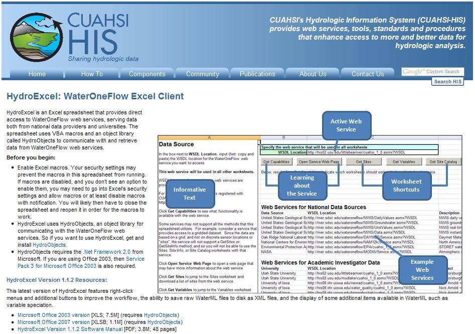
55 Streamflow Nutrients Water Temperature
56 Conceptual Framework Chemical descriptions from EPA/USGS Substance Registry System Physical descriptions from CF Conventions NetCDF Climate & Forecast; 137 variables pcmdi.llnl.gov/ Biological descriptions from Integrated Taxonomic Information System


57 Thematic Concepts Core Concept Property Branch Leaf Variables

58 HydroTagger Each Variable in your data is connected to a corresponding Concept
59 Water Temperature 6 services 11 variables 11,158 sites 22,953 series 1,546,841 records

60 HIS Central Web Page
 Date Range Data source (WaterOneFlow service) http://hiscentral.cuahsi.org/webservices/hiscentral.asmx")
61 HIS Central Web Service Programmatic methods to query the national metadata catalog Search by: Location Variable (concept) Date Range Data source (WaterOneFlow service)


62 HIS System HIS Desktop USGS Dat a University Web Service Data Registration HIS Central HIS Central Metadata Catalog Hydrologic Ontology Dat a HydroServers Data Access Data Discovery And Access Users (HydroDesktop)


63 HIS in Familiar Software
64 HydroExcel


65 Choosing a Service Tell HydroExcel which web service to use


66 Choosing a Site Google Earth opens, showing our sites Find sites and variables available from the web service GetSites GetSiteInfo GetVariableInfo GetValues WaterML WaterOneFlow Web Service Let s use this site

67 Downloading Time Series Input our site and a desired variable, e.g., net radiation, and tell HydroExcel to get the time series for March, 2007

68 Exploring the Time Series Explore time series using analytical capabilities of Excel
69 HydroExcel Limitations Can t hold much data No dates before year 1900 Not truly geospatially enabled Not free How can I use HIS in software built to work with HIS from the ground up?

70 HydroDesktop Free, open source solution for HIS data access

71 GIS fully integrated with HIS Metadata catalog Ontology keywords WaterOneFlow/WaterML Discovery Access Analysis

72 Built in Analysis Tables Graphs Editing Export

73 Customizable with Plug ins Community development Build on the HydroDesktop framework HydroModeler
74 Outline The HIS Story HIS components Putting the pieces together
75 Services Oriented Architecture for Water Data Catalog HIS Central HydroServer Service registration Data PublisherCatalog harvest WaterML Data access Search HydroDesktop User
76 The Road Ahead WaterML 2.0 Broader collaboration World Meteorological Organization Open Geospatial Consortium (OGC) Hydrology Domain Working Group Towards an OGC standard IEs groundwater, surface water RFC targeted for December, 2010 HydroServer Data access control HydroDesktop Refinement
77 The Road Further Ahead Using OGC Standards HydroCatalog (register) CSW HydroServer WFS SOS (WaterML 2) HydroDesktop

78 Put Your Dots on the Map


79 Start Using HIS HIS Website his.cuahsi.org User Support Specialist Yoori Choi
GIS in Water Resources
 GIS in Water Resources David R. Maidment Center for Research in Water Resources University of Texas at Austin GIS Day @ KU 19 November 2008 GIS and Water Resources WaterML Water Data Language Observations
Water Data Sharing an Update
 Water Data Sharing an Update By David R. Maidment Leader, CUAHSI Hydrologic Information System Project and Director, Center for Research in Water Resources, University of Texas at Austin Prepared for Subcommittee
Discovery and Access to Global Water Data, Maps and Services
 Discovery and Access to Global Water Data, Maps and Services David K. Arctur, PhD david.arctur@utexas.edu University of Texas at Austin Open Geospatial Consortium (OGC) Esri International User Conference
Observatories in the context of the Digital Continent: CZO s and HIS
 Observatories in the context of the Digital Continent: CZO s and HIS Dr. Richard P. Hooper, President, Consortium of Universities for the Advancement of Hydrologic Science, Inc. Why Observatories? From
Focus Areas. Colorado Rio Grande Jemez. San Pedro. An NSF Science and Technology Center SAHRA
 Focus Areas 1 San Pedro Colorado Rio Grande Jemez Geo-database Structure 2 SGB Schemas Upper Rio Grande Research Data Flux Tower Data Public Data Hydrology Rules, Users and Procedures Jemez River Colorado
The Open Geospatial Consortium and EarthCube
 The Open Geospatial Consortium and EarthCube An EarthCube Technology Paper Prepared by David Maidment 1, Ben Domenico 2, Alastair Gemmell 3, Kerstin Lehnert 4, David Tarboton 5 and Ilya Zaslavsky 6 Introduction
The Open Geospatial Consortium and EarthCube
 The Open Geospatial Consortium and EarthCube An EarthCube Technology Paper Prepared by David Maidment 1, Ben Domenico 2, Alastair Gemmell 3, Kerstin Lehnert 4, David Tarboton 5 and Ilya Zaslavsky 6 Introduction
Improving the Interoperability of Earth Observations. An EarthCube White Paper. Jeffery S. Horsburgh 1, David G. Tarboton 1.
 Improving the Interoperability of Earth Observations An EarthCube White Paper Jeffery S. Horsburgh 1, David G. Tarboton 1 October 16, 2011 1. Introduction In the history of science, many significant advances
Evaluating Physical, Chemical, and Biological Impacts from the Savannah Harbor Expansion Project Cooperative Agreement Number W912HZ
 Evaluating Physical, Chemical, and Biological Impacts from the Savannah Harbor Expansion Project Cooperative Agreement Number W912HZ-13-2-0013 Annual Report FY 2018 Submitted by Sergio Bernardes and Marguerite
Innovation. The Push and Pull at ESRI. September Kevin Daugherty Cadastral/Land Records Industry Solutions Manager
 Innovation The Push and Pull at ESRI September 2004 Kevin Daugherty Cadastral/Land Records Industry Solutions Manager The Push and The Pull The Push is the information technology that drives research and
Portals: Standards in Action
 Portals: Standards in Action David Danko ISO TC 211 Metadata Project Leader GIS Standards Consultant-ESRI. Metadata Portals Portal gateway, place of entry Producers Advertise, expose products Share information
Advancing Flood Detection and Preparedness through GEOSS Water Services
 Advancing Flood Detection and Preparedness through GEOSS Water Services David K. Arctur University of Texas at Austin Open Geospatial Consortium (OGC) CAHMDA/DAFOH Joint Workshop University of Texas at
GIS in Weather and Society
 GIS in Weather and Society Olga Wilhelmi Institute for the Study of Society and Environment National Center for Atmospheric Research WAS*IS November 8, 2005 Boulder, Colorado Presentation Outline GIS basic
Discovery and Access of Geospatial Resources using the Geoportal Extension. Marten Hogeweg Geoportal Extension Product Manager
 Discovery and Access of Geospatial Resources using the Geoportal Extension Marten Hogeweg Geoportal Extension Product Manager DISCOVERY AND ACCESS USING THE GEOPORTAL EXTENSION Geospatial Data Is Very
RHOAPS. Real-time Hydrology Ocean Atmosphere Prediction System. Pronunciation: Ropes Motto: More than just THREDDS
 RHOAPS Real-time Hydrology Ocean Atmosphere Prediction System Pronunciation: Ropes Motto: More than just THREDDS Key Aspects Integrated real-time data systems Atmospheric Hydrologic Coastal oceans Societal
These modules are covered with a brief information and practical in ArcGIS Software and open source software also like QGIS, ILWIS.
 Online GIS Training and training modules covered are: 1. ArcGIS, Analysis, Fundamentals and Implementation 2. ArcGIS Web Data Sharing 3. ArcGIS for Desktop 4. ArcGIS for Server These modules are covered
Services for Inland Marine Data Integration. USGS Center for Integrated
 Services for Inland Marine Data Integration USGS Center for Integrated Data Analytics Outline GeoDataPortal Tools Coastal Use Cases Beach hhealth lthmodeling Distributed Rainfall Analysis for Integration
Overview of Geospatial Open Source Software which is Robust, Feature Rich and Standards Compliant
 Overview of Geospatial Open Source Software which is Robust, Feature Rich and Standards Compliant Cameron SHORTER, Australia Key words: Open Source Geospatial Foundation, OSGeo, Open Standards, Open Geospatial
Spatial Data Infrastructure Concepts and Components. Douglas Nebert U.S. Federal Geographic Data Committee Secretariat
 Spatial Data Infrastructure Concepts and Components Douglas Nebert U.S. Federal Geographic Data Committee Secretariat August 2009 What is a Spatial Data Infrastructure (SDI)? The SDI provides a basis for
Web-Based Engine For Discovery Of Observations Using Landscape Units
 City University of New York (CUNY) CUNY Academic Works International Conference on Hydroinformatics 8-1-2014 Web-Based Engine For Discovery Of Observations Using Landscape Units Haowen Xu Abbas Ali Amir
Climate Data for Non-experts: Standards-based Interoperability
 Climate Data for Non-experts: Standards-based Interoperability Ben Domenico Unidata Program Center University Corporation for Atmospheric Research April 2010 Working Together on A Mosaic for Atmospheric
Evaluating Physical, Chemical, and Biological Impacts from the Savannah Harbor Expansion Project Cooperative Agreement Number W912HZ
 Evaluating Physical, Chemical, and Biological Impacts from the Savannah Harbor Expansion Project Cooperative Agreement Number W912HZ-13-2-0013 Second Quarterly Report - 2017 Submitted by Sergio Bernardes
You are Building Your Organization s Geographic Knowledge
 You are Building Your Organization s Geographic Knowledge And Increasingly Making it Available Sharing Data Publishing Maps and Geo-Apps Developing Collaborative Approaches Citizens Knowledge Workers Analysts
A Cloud-Based Flood Warning System For Forecasting Impacts to Transportation Infrastructure Systems
 A Cloud-Based Flood Warning System For Forecasting Impacts to Transportation Infrastructure Systems Jon Goodall Associate Professor, Civil and Environmental Engineering Associate Director, Link Lab April
Bentley Map V8i (SELECTseries 3)
") Bentley Map V8i (SELECTseries 3) A quick overview Why Bentley Map Viewing and editing of geospatial data from file based GIS formats, spatial databases and raster Assembling geospatial/non-geospatial data
Bentley Map V8i (SELECTseries 3) A quick overview Why Bentley Map Viewing and editing of geospatial data from file based GIS formats, spatial databases and raster Assembling geospatial/non-geospatial data
EUMETSAT s Support to Climate Services and User Support. Joachim Saalmüller
 EUMETSAT s Support to Climate Services and User Support Joachim Saalmüller 1 User Forum in Africa September 2016 Outline of my talk EUMETSAT in support of climate services Exploring our data and subscribing
Key Points Sharing fosters participation and collaboration Metadata has a big role in sharing Sharing is not always easy
 Sharing Resources Geoff Mortson esri, Inc. SDI Solutions Team Key Points Sharing fosters participation and collaboration Metadata has a big role in sharing Sharing is not always easy Data Sharing is Good
Using netcdf and HDF in ArcGIS. Nawajish Noman Dan Zimble Kevin Sigwart
 Using netcdf and HDF in ArcGIS Nawajish Noman Dan Zimble Kevin Sigwart Outline NetCDF and HDF in ArcGIS Visualization and Analysis Sharing Customization using Python Demo Future Directions Scientific Data
Evaluating Physical, Chemical, and Biological Impacts from the Savannah Harbor Expansion Project Cooperative Agreement Number W912HZ
 Evaluating Physical, Chemical, and Biological Impacts from the Savannah Harbor Expansion Project Cooperative Agreement Number W912HZ-13-2-0013 FY 2016 - First Quarterly Report January 1, 2016 Submitted
Atmospheric Science and GIS Interoperability issues: some Data Model and Computational Interface aspects
 UNIDATA Boulder, Sep. 2003 Atmospheric Science and GIS Interoperability issues: some Data and Computational Interface aspects Stefano Nativi University of Florence and IMAA-CNR Outline Service-Oriented
National Flood Interoperability Experiment
 National Flood Interoperability Experiment David R. Maidment, University of Texas at Austin Catchment-based Hydrological Data Assimilation (CAHMDA) VI Conference 8 September 2014 Located on Tuscaloosa
Experiences and Directions in National Portals"
 FIG Seminar on e-land Administration Innsbruck/Austria 2-4 June 2004 "ESRI's Experiences and Directions in National Portals" Kevin Daugherty Cadastral/Land Records Manager ESRI Topic Points Technology
Design and implementation of a new meteorology geographic information system
 Design and implementation of a new meteorology geographic information system WeiJiang Zheng, Bing. Luo, Zhengguang. Hu, Zhongliang. Lv National Meteorological Center, China Meteorological Administration,
Management and Sharing of Hydrologic Information of Cache County
 Geographic Information System in Water Resources CEE6440 Fall Semester 2012 Management and Sharing of Hydrologic Information of Cache County To: Dr. David Tarboton Instructor By: Tian Gan Dec.7, 2012 I.
WGISS-39 Tsukuba, Japan. RESTEC Kaori Kuroiwa
 CEOS Water Portal Overview and Status Update WGISS-39 Tsukuba, Japan JAXA Shinichi i SEKIOKA RESTEC Kaori Kuroiwa Contents 1. Overview (just a reminder ) 2. Updates New Architecture Development 3. Future
Guide to Hydrologic Information on the Web
 NOAA s National Weather Service Guide to Hydrologic Information on the Web Colorado River at Lees Ferry Photo: courtesy Tim Helble Your gateway to web resources provided through NOAA s Advanced Hydrologic
GIS at UCAR. The evolution of NCAR s GIS Initiative. Olga Wilhelmi ESIG-NCAR Unidata Workshop 24 June, 2003
 GIS at UCAR The evolution of NCAR s GIS Initiative Olga Wilhelmi ESIG-NCAR Unidata Workshop 24 June, 2003 Why GIS? z z z z More questions about various climatological, meteorological, hydrological and
WEB-BASED SPATIAL DECISION SUPPORT: TECHNICAL FOUNDATIONS AND APPLICATIONS
 WEB-BASED SPATIAL DECISION SUPPORT: TECHNICAL FOUNDATIONS AND APPLICATIONS Claus Rinner University of Muenster, Germany Piotr Jankowski San Diego State University, USA Keywords: geographic information
Geoscience Information Network (US GIN)
") Geoscience Information Network (US GIN) 1,000 s of databases 1,000 s of collections 80,000+ geologic maps Distributed Web-based Interoperable Open source A different business model Traditional Lobby Congress
Geoscience Information Network (US GIN) 1,000 s of databases 1,000 s of collections 80,000+ geologic maps Distributed Web-based Interoperable Open source A different business model Traditional Lobby Congress
Water Information Portal User Guide. Updated July 2014
 Water Information Portal User Guide Updated July 2014 1. ENTER THE WATER INFORMATION PORTAL Launch the Water Information Portal in your internet browser via http://www.bcogc.ca/public-zone/water-information
Semantic Evolution of Geospatial Web Services: Use Cases and Experiments in the Geospatial Semantic Web
 Semantic Evolution of Geospatial Web Services: Use Cases and Experiments in the Geospatial Semantic Web Joshua Lieberman, Todd Pehle, Mike Dean Traverse Technologies, Inc., Northrop Grumman Information
Features and Benefits
 Autodesk LandXplorer Features and Benefits Use the Autodesk LandXplorer software family to help improve decision making, lower costs, view and share changes, and avoid the expense of creating physical
Regione Umbria. ESRI EMEA User Conference 2010 Rome, October 27th 2010
 Direzione Ambiente, Territorio e Infrastrutture Servizio Informatico/Informativo: geografico, ambientale e territoriale ESRI EMEA User Conference 2010 Rome, October 27th 2010 Arch. Ambra Ciarapica, Dott.
WEB MAP SERVICE (WMS) FOR GEOLOGICAL DATA GEORGE TUDOR
 FOR GEOLOGICAL DATA GEORGE TUDOR") WEB MAP SERVICE (WMS) FOR GEOLOGICAL DATA GEORGE TUDOR WEB MAP SERVICE (WMS) - GENERALITIES Projects with data from different sources Geological data are in different GIS software format Large amount of
WEB MAP SERVICE (WMS) FOR GEOLOGICAL DATA GEORGE TUDOR WEB MAP SERVICE (WMS) - GENERALITIES Projects with data from different sources Geological data are in different GIS software format Large amount of
Implementing INSPIRE Geoportal in Turkey
 Implementing INSPIRE Geoportal in Turkey Gencay SERTER City and Regional Planner 1 Presentation Plan Introduction INSPIRE and Turkey Importance of al Spatial Planning Portal Logical&Legal Hierarchy GeoPortal
ArcGIS for INSPIRE. Marten Hogeweg
 ArcGIS for INSPIRE Marten Hogeweg Please Take Our Survey on the App Download the Esri Events app and find your event Select the session you attended Scroll down to find the feedback section Complete answers
Global Geospatial Information Management Country Report Finland. Submitted by Director General Jarmo Ratia, National Land Survey
 Global Geospatial Information Management Country Report Finland Submitted by Director General Jarmo Ratia, National Land Survey Global Geospatial Information Management Country Report Finland Background
GIS in Water Resources Midterm Exam Fall 2008 There are 4 questions on this exam. Please do all 4.
 Page 1 of 8 Name: GIS in Water Resources Midterm Exam Fall 2008 There are 4 questions on this exam. Please do all 4. 1. Basic Concepts [20 points] Find the letter with the best answer for each term: 1.
Data Aggregation with InfraWorks and ArcGIS for Visualization, Analysis, and Planning
 Data Aggregation with InfraWorks and ArcGIS for Visualization, Analysis, and Planning Stephen Brockwell President, Brockwell IT Consulting, Inc. Join the conversation #AU2017 KEYWORD Class Summary Silos
Methodological Chain for Hydrological Management with Web-GIS Applications
 Advances in Geosciences Konstantinos Perakis & Athanasios Moysiadis, Editors EARSeL, 2012 Methodological Chain for Hydrological Management with Web-GIS Applications Alexandros Konstantinidis 1, Eleni Tzanou
USING GIS TO MODEL AND ANALYZE HISTORICAL FLOODING OF THE GUADALUPE RIVER NEAR NEW BRAUNFELS, TEXAS
 USING GIS TO MODEL AND ANALYZE HISTORICAL FLOODING OF THE GUADALUPE RIVER NEAR NEW BRAUNFELS, TEXAS ASHLEY EVANS While the state of Texas is well-known for flooding, the Guadalupe River Basin is one of
Streamlined Watershed Modeling with the Kentucky Watershed Modeling Information Portal (KWMIP)
") Streamlined Watershed Modeling with the Kentucky Watershed Modeling Information Portal (KWMIP) JSEM 2007 Geospatial Technical Session Columbus, Ohio May 23, 2007 Ray Rush, PE Information Solutions Manager
Streamlined Watershed Modeling with the Kentucky Watershed Modeling Information Portal (KWMIP) JSEM 2007 Geospatial Technical Session Columbus, Ohio May 23, 2007 Ray Rush, PE Information Solutions Manager
Accessing and Using National Long Term Ecological Research (LTER) Climate and Hydrology Data from ClimDB and HydroDB: A Tutorial
 Climate and Hydrology Data from ClimDB and HydroDB: A Tutorial") Accessing and Using National Long Term Ecological Research (LTER) Climate and Hydrology Data from ClimDB and HydroDB: A Tutorial Gordon M. Heisler USDA Forest Service, Syracuse, NY Gary Fisher U.S. Geological
Accessing and Using National Long Term Ecological Research (LTER) Climate and Hydrology Data from ClimDB and HydroDB: A Tutorial Gordon M. Heisler USDA Forest Service, Syracuse, NY Gary Fisher U.S. Geological
A.C.R.E and. C3S Data Rescue Capacity Building Workshops. December 4-8, 2017 Auckland, New Zealand. Session 3: Rescue of Large Format and Analog Data
 A.C.R.E and C3S Data Rescue Capacity Building Workshops December 4-8, 2017 Auckland, New Zealand Dr. Rick Crouthamel, D.Sc. Executive Director Session 3: Rescue of Large Format and Analog Data 4 December
A Model of GIS Interoperability Based on JavaRMI
 A Model of GIS Interoperability Based on Java Gao Gang-yi 1 Chen Hai-bo 2 1 Zhejiang University of Finance & Economics, Hangzhou 310018, China 2 College of Computer Science and Technology, Zhejiang UniversityHangzhou
Development of a Web-Based GIS Management System for Agricultural Authorities in Iraq
 Development of a Web-Based GIS Management System for Agricultural Authorities in Iraq USCID Water Management Conference Phoenix, Arizona April 18, 2013 Gabriele Bonaiti Extension Program Specialist David
Geospatial Data, Services, and Products. National Surveying, mapping and geospatial conference
 Geospatial Data, Services, and Products Federal Programs -- USDA NRCS National Surveying, mapping and geospatial conference March 15, 2016 NRCS Applications using Geosaptial Products & Services Field
Data Aggregation with InfraWorks and ArcGIS for Visualization, Analysis, and Planning
 CI125230 Data Aggregation with InfraWorks and ArcGIS for Visualization, Analysis, and Planning Stephen Brockwell Brockwell IT Consulting Inc. Sean Kinahan Brockwell IT Consulting Inc. Learning Objectives
Leveraging the OGC Capabilities of ArcGIS Server
 Leveraging the OGC Capabilities of ArcGIS Server Satish Sankaran Interoperability and Standards Team Yingqi Tang Server Team Jessica Parteno Geodatabase Team ArcGIS Server is Open & Interoperable Using
INSPIREd solutions for Air Quality problems Alexander Kotsev
 INSPIREd solutions for Air Quality problems Alexander Kotsev www.jrc.ec.europa.eu Serving society Stimulating innovation Supporting legislation The European data puzzle The European data puzzle 24 official
Introduction to ArcGIS Maps for Office. Greg Ponto Scott Ball
 Introduction to ArcGIS Maps for Office Greg Ponto Scott Ball Agenda What is Maps for Office? Platform overview What are Apps for the Office? ArcGIS Maps for Office features - Visualization - Geoenrichment
GIS-based Smart Campus System using 3D Modeling
 GIS-based Smart Campus System using 3D Modeling Smita Sengupta GISE Advance Research Lab. IIT Bombay, Powai Mumbai 400 076, India smitas@cse.iitb.ac.in Concept of Smart Campus System Overview of IITB Campus
Development of a GIS Interface for WEPP Model Application to Great Lakes Forested Watersheds
 Development of a GIS Interface for WEPP Model Application to Great Lakes Forested Watersheds J.R. Frankenberger 1, S. Dun 2, D.C. Flanagan 1, J.Q. Wu 2, W.J. Elliot 3 1 USDA-ARS, West Lafayette, IN 2 Washington
The National Operational Hydrologic Remote Sensing Center Operational Snow Analysis
 The National Operational Hydrologic Remote Sensing Center Operational Snow Analysis World Meteorological Organization Global Cryosphere Watch Snow-Watch Workshop Session 3: Snow Analysis Products Andrew
What s new in GIS. RAL Retreat Oct 5, 2005
 What s new in GIS RAL Retreat Oct 5, 2005 Overview GIS Initiative milestones Major activities in 2004-2005 GALEON UNIDATA OGC project New functionality in ESRI software GIS Initiative Team Olga Wilhelmi
Finnish Open Data Portal for Meteorological Data
 18.11.2013 1 Finnish Open Data Portal for Meteorological Data 14th Workshop on meteorological operational systems Roope Tervo Finnish Meteorological Institute Example of Data Sets -- Observations Data
What s New in Topographic Information - USGS National Map
 + What s New in Topographic Information - USGS National Map SARGIS Workshop November 14, 2016 Rob Dollison, 703-648-5724 rdollison@usgs.gov + USGS 2 National Geospatial Program The National Geospatial
StreamStats: Delivering Streamflow Information to the Public. By Kernell Ries
 StreamStats: Delivering Streamflow Information to the Public By Kernell Ries U.S. Department of the Interior U.S. Geological Survey MD-DE-DC District 410-238-4317 kries@usgs.gov StreamStats Web Application
Introduction to the 176A labs and ArcGIS Purpose of the labs
 Introduction to the 176A labs and ArcGIS Purpose of the labs Acknowledgement: Slides by David Maidment, U Texas-Austin and Francisco Olivera (TAMU) Hands-on experience with a leading software package Introduction
ArcGIS Online Tools and Water-Related Web Services You Can Use Every Day of Your Life!
 ArcGIS Online Tools and Water-Related Web Services You Can Use Every Day of Your Life! Brian Rowley, PE, CFM FMA 2014 Annual Conference 1 Gold Rush (49ers) John Sutter Sutter s Mill South fork of American
Free and Open Source Software for Cadastre and Land Registration : A Hidden Treasure? Gertrude Pieper Espada. Overview
 Free and Open Source Software for Cadastre and Land Registration : A Hidden Treasure? Gertrude Pieper Espada Overview FLOSS concepts Digital Land Administration systems FLOSS Database alternatives FLOSS
Paper UC1351. Conference: User Conference Date: 08/10/2006 Time: 8:30am-9:45am Room: Room 23-B (SDCC)
") Conference: User Conference Date: 08/10/2006 Time: 8:30am-9:45am Room: Room 23-B (SDCC) Title of Paper: Increasing the Use of GIS in the Federal Government Author Name: Miss Abstract This presentation
Conference: User Conference Date: 08/10/2006 Time: 8:30am-9:45am Room: Room 23-B (SDCC) Title of Paper: Increasing the Use of GIS in the Federal Government Author Name: Miss Abstract This presentation
Portal for ArcGIS: An Introduction. Catherine Hynes and Derek Law
 Portal for ArcGIS: An Introduction Catherine Hynes and Derek Law Agenda Web GIS pattern Product overview Installation and deployment Configuration options Security options and groups Portal for ArcGIS
GEOSPATIAL WEB SERVICE INTEGRATION AND MASHUPS FOR WATER RESOURCE APPLICATIONS
 GEOSPATIAL WEB SERVICE INTEGRATION AND MASHUPS FOR WATER RESOURCE APPLICATIONS C. Granell a, *, L. Díaz a, M. Gould a a Center for Interactive Visualization, Department of Information Systems, Universitat
Geospatial Products V8i (SELECTseries 1)
") Geospatial Products V8i (SELECTseries 1) Keith Raymond Product Manager Geospatial Desktop Products Presentation Overview What are the various products? Why would you need them? Demonstrations 2 WWW.BENTLEY.COM
Geospatial Products V8i (SELECTseries 1) Keith Raymond Product Manager Geospatial Desktop Products Presentation Overview What are the various products? Why would you need them? Demonstrations 2 WWW.BENTLEY.COM
Instituto de Pesquisas Meteorológicas - IPMet Universidade Estadual Paulista - Unesp
 IPMET WEB GIS APPLICATION FOR SEVERE WEATHER ALERT AND DECISION SUPPORT Jaqueline Murakami Kokitsu Instituto de Pesquisas Meteorológicas - IPMet Universidade Estadual Paulista - Unesp IPMet/Unesp Meteorological
Imagery and the Location-enabled Platform in State and Local Government
 Imagery and the Location-enabled Platform in State and Local Government Fred Limp, Director, CAST Jim Farley, Vice President, Leica Geosystems Oracle Spatial Users Group Denver, March 10, 2005 TM TM Discussion
Regional Drought Decision Support System (RDDSS) Project Update and Product Concepts
 Project Update and Product Concepts") Regional Drought Decision Support System (RDDSS) Project Update and Product Concepts Part of the Red River Basin Decision Information Network (RRBDIN) NEXT-GEN RRBDIN Decision Support for the Red River
Regional Drought Decision Support System (RDDSS) Project Update and Product Concepts Part of the Red River Basin Decision Information Network (RRBDIN) NEXT-GEN RRBDIN Decision Support for the Red River
THE WASHINGTON COASTAL ATLAS
 THE ICAN COASTAL ATLAS MEDIATOR PROTOTYPE AND CONNECTING THE WASHINGTON COASTAL ATLAS Liz O Dea 1, Yassine Lassoued 2, Tanya Haddad 3, Declan Dunne 2 1 GIS Services Unit, WA State Dept. of Ecology 2 Coastal
Overdracht van terrein informatie dmv een GIS internettoepassing bij de OVAM
 1 1. General Introduction... 2 1.1. GIS.... 2 1.1.1. What is a GIS?... 2 1.1.2. The Philosophy of a GIS... 2 1.1.3. Aspects of a GIS project... 3 1.1.4. Intergraph and GeoMedia... 4 1.2. OVAM... 5 1.2.1.
ArcGIS for INSPIRE. Marten Hogeweg Satish Sankaran
 ArcGIS for INSPIRE Marten Hogeweg Satish Sankaran Outline What is ArcGIS ArcGIS for INSPIRE Web GIS Case Studies Roadmap Q&A What is INSPIRE? INSPIRE is the legal framework for a European Spatial Data
A Comparative Study of the National Water Model Forecast to Observed Streamflow Data
 A Comparative Study of the National Water Model Forecast to Observed Streamflow Data CE394K GIS in Water Resources Term Project Report Fall 2018 Leah Huling Introduction As global temperatures increase,
Geospatial data access and Decision-Support tools for Coastal Systems
 Workshop A-1 Sunday March 25, Morning Session 8:00 AM 12:00 Noon Cost: $106.00 Geospatial data access and Decision-Support tools for Coastal Systems Todd Plessel (Plessel.Todd@mintra.epa.gov) Stephen Bourne
River Modeling as Big as Texas. Cédric H. David David R. Maidment, Zong-Liang Yang
 River Modeling as Big as Texas Cédric H. David David R. Maidment, Zong-Liang Yang First Water Forum Austin, TX 13 February 2012 1 Atmospheric modeling Equations of fluid mechanics and thermodynamics of
USGS Hydrography Overview. May 9, 2018
 + 1 USGS Hydrography Overview May 9, 2018 + 2 The National Geospatial Program Provides the geospatial baseline of the Nation s topography, natural landscape and built environment through The National Map,
European Location Framework data in the ArcGIS platform
 European Location Framework data in the ArcGIS platform Presentation to: Author: Date: INSPIRE Conference 2016 Clemens Portele 26 September 2016 Why ELF? Global (e.g. UN GGIM) Regional Europe (INSPIRE
Web GIS Based Disaster Portal Project ESRI INDIA
 Web GIS Based Disaster Portal Project ESRI INDIA Contents Requirements Overview Product Technology Used KSNDMC Application Architecture Tool Developed Benefits for the End User Problems faced during implementation
Creation of an Internet Based Indiana Water Quality Atlas (IWQA)
") Department of Environmental Management Creation of an Internet Based Water Quality Atlas (IWQA) May 4, 2005 IUPUI 1200 Waterway Blvd., Suite 100 polis, 46202-5140 Water Quality Atlas John Buechler, Neil
Department of Environmental Management Creation of an Internet Based Water Quality Atlas (IWQA) May 4, 2005 IUPUI 1200 Waterway Blvd., Suite 100 polis, 46202-5140 Water Quality Atlas John Buechler, Neil
THE SPATIAL DATA SERVER BASED ON OPEN GIS STANDARDS IN HETEROGENEOUS DISTRIBUTED ENVIRONMENT
 Geoinformatics 2004 Proc. 12th Int. Conf. on Geoinformatics Geospatial Information Research: Bridging the Pacific and Atlantic University of Gävle, Sweden, 7-9 June 2004 THE SPATIAL DATA SERVER BASED ON
Hosted by Esri Official Distributor
 Hosted by Esri Official Distributor Esri European User Conference October 15-17, 2012 Oslo, Norway Hosted by Esri Official Distributor Interoperability and Standards Support in ArcGIS 10.1 Roberto Lucchi
Analyzing Multidimensional Scientific Data in ArcGIS. Nawajish Noman Deng Ding
 Analyzing Multidimensional Scientific Data in ArcGIS Nawajish Noman Deng Ding Outline Part I - ArcGIS Platform - Scientific Multidimensional Data - Ingest and Data Management Part II - Data Exploration
Ministry of Health and Long-Term Care Geographic Information System (GIS) Strategy An Overview of the Strategy Implementation Plan November 2009
 Strategy An Overview of the Strategy Implementation Plan November 2009") Ministry of Health and Long-Term Care Geographic Information System (GIS) Strategy An Overview of the Strategy Implementation Plan November 2009 John Hill, Health Analytics Branch Health System Information
Ministry of Health and Long-Term Care Geographic Information System (GIS) Strategy An Overview of the Strategy Implementation Plan November 2009 John Hill, Health Analytics Branch Health System Information
Application of GIS Technology in Watershed-based Management and Decision Making
 Application of GIS Technology in Watershed-based Management and Decision Making U. Sunday Tim Iowa State University Department of Agricultural and Biosystems Engineering 100 Davidson Hall Email:
Safe to Save? Archive Options for Geodatabases. Jeff Essic North Carolina State University Libraries
 Safe to Save? Archive Options for Geodatabases Jeff Essic North Carolina State University Libraries 2011 ESRI International Users Conference July 13, 2011 GeoMAPP Geospatial Multistate Archive and Preservation
Evaluating Physical, Chemical, and Biological Impacts from the Savannah Harbor Expansion Project Cooperative Agreement Number W912HZ
 Evaluating Physical, Chemical, and Biological Impacts from the Savannah Harbor Expansion Project Cooperative Agreement Number W912HZ-13-2-0013 Annual Report FY 2017 Submitted by Sergio Bernardes and Marguerite
The EOC Geoservice: Standardized Access to Earth Observation Data Sets and Value Added Products
 The EOC Geoservice: Standardized Access to Earth Observation Data Sets and Value Added Products Klaus Dengler, Torsten Heinen, Albert Huber, Katrin Molch, Eberhard Mikusch DLR German Remote Sensing Data
INSPIRing Geospatial Framework For Local Administrations
 This project is financed by the European Union and the Republic of Turkey Presented at the FIG Congress 2018, May 6-11, 2018 in Istanbul, Turkey National Programme for Turkey 2010 Instrument for Pre-Accession
Mid course Progress and Opportunities for Unidata Outreach. Ben Domenico May 2011
 Mid course Progress and Opportunities for Unidata Outreach Ben Domenico May 2011 Outline Overview Relationship to Unidata 2013 Proposal Collaborating Communities Recent Progress Current Focus Future Directions
Questions and Answers
 AUTODESK LANDXPLORER SOFTWARE FAMILY Questions and Answers The Autodesk LandXplorer 3D city model software family can help you create, analyze, and visualize digital city models. Contents Autodesk Landxplorer
USDA CropScape Data Resources
 USDA CropScape Data Resources Zhengwei Yang, Claire Boryan, Rick Mueller USDA National Agricultural Statistics Service, Washington, DC 20250, USA Collaborators: Liping Di, Weiguo Han Center for Spatial