THE WASHINGTON COASTAL ATLAS
|
|
|
- Catherine Walker
- 6 years ago
- Views:
Transcription


1 THE ICAN COASTAL ATLAS MEDIATOR PROTOTYPE AND CONNECTING THE WASHINGTON COASTAL ATLAS Liz O Dea 1, Yassine Lassoued 2, Tanya Haddad 3, Declan Dunne 2 1 GIS Services Unit, WA State Dept. of Ecology 2 Coastal & Marine Resources Centre, Univ. College Cork, Ireland 3 Oregon Coastal Management Program airninja.com


2 1. ICAN Atlas Mediator Prototype 2. Connecting the WA Coastal Atlas to the ICAN Prototype 3. Conclusions
3

4 A web portal where people can search for spatial data from multiple coastal atlases. A single test case: coastal erosion A demonstration of how independent atlases can be connected.

5 Long-term: Develop an internationallyenabled Coastal Web Atlas (CWA) ontology Users will be able to conduct sophisticated and meaningful queries across a range of atlases from one site. Short-term: A proof-of-concept exercise Focus on one theme Demonstrate the technology and use of standards Make connections within regional partnerships Build and strengthen atlas networks (West Coast, US, Europe, etc.)


6 Search All Atlases: Global Ontology


7 Search by Area

8 Search by Atlases

9 Search Results


 Further expansion as funding")
10 Search by Atlas: Uses Local Ontology Currently 3 atlases connected - More atlases added in next 6 mos (Washington, Wisconsin, Africa, Carribbean, Andalucia,?) Further expansion as funding allows - Scope and number
 Local Ontologies (Oregon, MIDA, Washington, etc) OGC Services (CSW) Balance of Mediation and Harmonisation Web site designed using Adobe Flex,")
11 Centralised system Resources are accessed through one central system (ICAN global atlas) Virtual integration approach Data are not copied into the global Atlas Controlled Vocabularies/Ontologies Global Ontology (ICAN) Local Ontologies (Oregon, MIDA, Washington, etc) OGC Services (CSW) Balance of Mediation and Harmonisation Web site designed using Adobe Flex, Java and SparQL queries


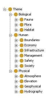
12 Controlled Vocabularies are list of terms Ontologies connect these terms to each other mapping Ontology: A Knowledge Organisation System Define concepts (categories and subjects: ex: borders and coastline) Define relationships between those concepts Local Ontology terms connect to the Global Ontology Make it easier to search Note: ICAN Coastal Erosion Ontology was extracted from the USGS Coastal Hazards Ontology.
 Allows requests for geographic resources across the Web using platform-independent calls CSW Request Get")

13 OGC web services Catalogue Service for the Web (CSW) Web Map Service (WMS) Web Feature Service (WFS) Web Coverage Service (WCS) Allows requests for geographic resources across the Web using platform-independent calls CSW Request Get Capabilities Get Records Get Record By ID Response Metadata about the types / operations the CSW supports Metadata records available, with possibility of filtering (bounding box, spatial, temporal, keywords search, etc.) Record with the specified ID


14 Atlases have autonomy Hold, distribute and organize their own data Use software of their choice Harmonization and Mediation

15 1. Harmonisation: Harmonize access interfaces to atlases Implement OGC Web Services Harmonize resource formats Use ISO metadata standards ISO & ISO-19139, FGDC Harmonise Web querying and delivery formats OGC queries for geographic resources Delivery of XML for metadata, GML for data, etc.
 COTS (GIS Portal Toolkit) Use a")

16 2. Mediation: Allow local atlases to use their own data structures, semantics, vocabularies (ontologies) Allow local atlases to choose OGC-compliant software Open Source (GeoNetwork) COTS (GIS Portal Toolkit) Use a common data structure and a common ontology for the global atlas Provide mappings between terms in local ontologies and the global ontology Mapping Example: ICAN global ontology:coastline is similar to WCA ontology:shoreline


17 Time for a Live Demo!

18 Will include WMS in time for the next ICAN Workshop in November 2009 in Trieste, Italy Possibly include WFS before then Future depends on funding opportunities Current development done with donated time Looking for grants in US and Europe to fund expanding: The scope Broaden the topics included The scale The number of atlases involved
 Get input from coastal hazards expert 4.")
19 1. Pick OGC compliant software (CSW, WMS, WFS) Install and set up as CSW 2. Develop Coastal Erosion Controlled Vocabulary 3. Map Local Ontology Map how terms relate to each other (Protégé software) Get input from coastal hazards expert 4. Coordinate with ICAN Ontology master Submit WCA ontology He maps WCA ontology to super ontology Adds WCA as a node in the Atlas Mediator Prototype 5. Test that ICAN prototype can search WCA CSW Refine as needed May occasionally be tweaks to ontology 6. Implement WCA WMS and test with ICAN prototype Outcome: WCA Metadata will be searchable, just as current connected atlases are.

20 Chosen to fit Dept. of Ecology s Enterprise system ArcGIS Server Extension Catalog and Search resources Build portals, SDIs, Metadata catalogs Ex: Geospatial One-Stop, NOAA Large Marine Ecosystems OGC Compliant Catalog Service for the Web (CSW): Requires editing a line in web.config Installation issues: Does not yet support SQL 2008 Access to CSW through Firewall No filters for providing limited access to target user groups Must install multiple GPT instances

21


22 ICAN Ontology Mappings 1. User selects search criteria 2. Refers to local ontologies and mappings 3. If there, sends query to local CSW 4. Resulting metadata returned to ICAN and displayed MIDA Ontology OCA Ontology WCA Ontology CSW WMS WFS CSW WMS WFS CSW WMS WFS Washington Coastal Atlas
 ESRI GIS Portal Toolkit CSW")


23 Key Architecture of The Washington Coastal Atlas: Connecting with the ICAN Atlas Mediator ArcSDE 9.3 Ecology & WCA Geospatial Data ICAN Atlas Mediator: Search View MD Map Viewer (future) ESRI GIS Portal Toolkit CSW ArcGIS Server 9.3 Washington Coastal Atlas Metadata WMS/ WFS WMS/ WFS WMS/ WFS Other Atlases Washington Coastal Atlas Map Services SQL Server 2005 Geo- Network CSW Oregon Coastal Atlas Geo- Network CSW Marine Irish Digital Atlas Geo- Network CSW Belgian Coastal Atlas Wisconsin Lake Superior Coastal Mapping Portal WMS/ WFS Washington Dept of Ecology CSW: Catalogue Service for the Web (OGC) WMS: Web Map Service (OGC) WFS: Web Feature Service (OGC) MD: Metadata : Future endeavors

24 Coastal Atlases provide an array of geographically based information which can inform coastal scientific, policy and planning work. Sharing data across borders can: Improve ecosystem management Help communicate priorities and needs Make cross-border management of natural resources easier and likely more effective Enhance communication among scientists regarding existing conditions It is feasible to implement collaborative tools to improve access to coastal data Dedication, support and openness to sharing


25 International Coastal Atlas Network Technical Group: ICAN Atlas Mediator Prototype: Liz O Dea GIS Analyst lode461@ecy.wa.gov
The Research Agenda of the Wisconsin Coastal Atlas
 The Research Agenda of the Wisconsin Coastal Atlas David Hart GIS Specialist University of Wisconsin Sea Grant Institute International Coastal Atlas Network Workshop 4 Trieste, Italy Tuesday, November
Assessing the Robustness of Web Feature Services Necessary to Satisfy the Requirements of Coastal Management
 Assessing the Robustness of Web Feature Services Necessary to Satisfy the Requirements of Coastal Management Jennifer Bauer M.S. Geography GISci Certificate June 4, 2012 Presentation Outline!! Background
Practical experience in the management, analysis and visualisation of marine data and information
 Practical experience in the management, analysis and visualisation of marine data and information Dr. Ned Dwyer Coastal and Marine Research Centre, Cork, Ireland n.dwyer@ucc.ie Introduction Chapter 1 Marine
Portals: Standards in Action
 Portals: Standards in Action David Danko ISO TC 211 Metadata Project Leader GIS Standards Consultant-ESRI. Metadata Portals Portal gateway, place of entry Producers Advertise, expose products Share information
Spatial Data Infrastructure Concepts and Components. Douglas Nebert U.S. Federal Geographic Data Committee Secretariat
 Spatial Data Infrastructure Concepts and Components Douglas Nebert U.S. Federal Geographic Data Committee Secretariat August 2009 What is a Spatial Data Infrastructure (SDI)? The SDI provides a basis for
SDI Standards at work
 SDI Standards at work Jan Juul Jensen Senior Technology Strategist Informi GIS Denmark Informi GIS Private held Limited Company Specialized in GIS 100+ employees HQ in Charlottenlund, Copenhagen Regional
From the Venice Lagoon Atlas towards a collaborative federated system
 From the Venice Lagoon Atlas towards a collaborative federated system City of Venice Alessandro Mulazzani CORILA Consortium for Coordination of Research Activities Concerning the Venice Lagoon System ISMAR-CNR
Semantic Mediation as a Gateway to Interoperability, with a Case Study of the International Coastal Atlas Network (ICAN)
") 1 Semantic Mediation as a Gateway to Interoperability, with a Case Study of the International Coastal Atlas Network (ICAN) Yassine Lassoued 1, Dawn Wright 2, Luis Bermudez 3, Tim Nyerges 4, Tanya Haddad
1 Semantic Mediation as a Gateway to Interoperability, with a Case Study of the International Coastal Atlas Network (ICAN) Yassine Lassoued 1, Dawn Wright 2, Luis Bermudez 3, Tim Nyerges 4, Tanya Haddad
Reprint of article that appeared in Hydro INTERNATIONAL November 2006 Volume 10 Issue 9
 Reprint of article that appeared in Hydro INTERNATIONAL November 2006 Volume 10 Issue 9 While Google Earth is the best known 3D web-mapping viewer currently in the public domain, there are alternative
Spatial data interoperability and INSPIRE compliance the platform approach BAGIS
 Spatial data interoperability and INSPIRE compliance the platform approach BAGIS BAGIS Voluntary, independent, public, non-profit organization; Organization with main mission to promote the growth of the
EXPECTATIONS OF TURKISH ENVIRONMENTAL SECTOR FROM INSPIRE
 EXPECTATIONS OF TURKISH ENVIRONMENTAL SECTOR FROM INSPIRE June, 2010 Ahmet ÇİVİ Tuncay DEMİR INSPIRE in the Eyes of MoEF Handling of Geodata by MoEF Benefits Expected TEIEN First Steps for INSPIRE Final
Finding geodata that otherwise would have been forgotten GeoXchange a portal for free geodata
 Finding geodata that otherwise would have been forgotten GeoXchange a portal for free geodata Sven Tschirner and Alexander Zipf University of Applied Sciences FH Mainz Department of Geoinformatics and
African Coastal Atlas developments. 10 July 2008 EEA Copenhagen, Denmark
 African Coastal Atlas developments 10 July 2008 EEA Copenhagen, Denmark Africa Overview Africa has approximately 40 000 km of coast across 32 mainland countries and four island states. Africa's coastal
Implementing INSPIRE Geoportal in Turkey
 Implementing INSPIRE Geoportal in Turkey Gencay SERTER City and Regional Planner 1 Presentation Plan Introduction INSPIRE and Turkey Importance of al Spatial Planning Portal Logical&Legal Hierarchy GeoPortal
ArcGIS for INSPIRE. Marten Hogeweg Satish Sankaran
 ArcGIS for INSPIRE Marten Hogeweg Satish Sankaran Outline What is ArcGIS ArcGIS for INSPIRE Web GIS Case Studies Roadmap Q&A What is INSPIRE? INSPIRE is the legal framework for a European Spatial Data
International Coastal Atlas Network
 International Coastal Atlas Network c/o Oregon State University Dept. of Geosciences, Oregon State University, 104 Wilkinson Hall Corvallis, OR 97331-5506, USA Telephone: +1-541-737-1201 Facsimile: +1-541-737-1200
Hosted by Esri Official Distributor
 Hosted by Esri Official Distributor Esri European User Conference October 15-17, 2012 Oslo, Norway Hosted by Esri Official Distributor Interoperability and Standards Support in ArcGIS 10.1 Roberto Lucchi
The Newsletter of the International Coastal Atlas Network
 The Newsletter of the International Coastal Atlas Network Introduction SCOTLAND S MARINE ATLAS JOINS ICAN Martyn Cox Marine Planning and Policy Marine Scotland Martyn.cox@scotland.gsi.gov.uk Volume One
Wisconsin Coastal Atlas Building the Coastal Spatial Data Infrastructure to Promote Hazard Resilience on the Great Lakes
 Wisconsin Coastal Atlas Building the Coastal Spatial Data Infrastructure to Promote Hazard Resilience on the Great Lakes David Hart GIS Specialist University of Wisconsin Sea Grant Institute ASPRS - Great
A Spatial Data Infrastructure dedicated to scientific research and observation of the coastal environment
 A Spatial Data Infrastructure dedicated to scientific research and observation of the coastal environment http://indigeo.fr Mathias ROUAN - Research Engineer - UMR 6554 LETG CNRS Littoral, Environment,
Discovery and Access of Geospatial Resources using the Geoportal Extension. Marten Hogeweg Geoportal Extension Product Manager
 Discovery and Access of Geospatial Resources using the Geoportal Extension Marten Hogeweg Geoportal Extension Product Manager DISCOVERY AND ACCESS USING THE GEOPORTAL EXTENSION Geospatial Data Is Very
Introducing the. a partnership of
 Introducing the a partnership of Background Need for online atlas identified by managers and researchers to make coastal data available Shoreline data Ocean and coastal resources Sea-level rise potential
ArcGIS for INSPIRE. Marten Hogeweg
 ArcGIS for INSPIRE Marten Hogeweg Please Take Our Survey on the App Download the Esri Events app and find your event Select the session you attended Scroll down to find the feedback section Complete answers
Technical Framework Methodology as a core of building up the NSDI NSDI Implementation Specifics in Serbia
 Technical Framework Methodology as a core of building up the NSDI NSDI Implementation Specifics in Serbia Luka Jovičić SDI Consultant@ Gramont Ltd. Aleksandar Dedić RGA NSDI department Dragica Pajić RGA
ICAN Great Lakes Workshop
 Washington Coastal latlas ICAN Great Lakes Workshop September 13 15, 15 2010 Current Washington Coastal Atlas http://www.ecy.wa.gov/programs/sea/sma/atlas_home.html 1 st version of WA Coastal Atlas was
Paper UC1351. Conference: User Conference Date: 08/10/2006 Time: 8:30am-9:45am Room: Room 23-B (SDCC)
") Conference: User Conference Date: 08/10/2006 Time: 8:30am-9:45am Room: Room 23-B (SDCC) Title of Paper: Increasing the Use of GIS in the Federal Government Author Name: Miss Abstract This presentation
Conference: User Conference Date: 08/10/2006 Time: 8:30am-9:45am Room: Room 23-B (SDCC) Title of Paper: Increasing the Use of GIS in the Federal Government Author Name: Miss Abstract This presentation
Leveraging the OGC Capabilities of ArcGIS Server
 Leveraging the OGC Capabilities of ArcGIS Server Satish Sankaran Interoperability and Standards Team Yingqi Tang Server Team Jessica Parteno Geodatabase Team ArcGIS Server is Open & Interoperable Using
GIS at UCAR. The evolution of NCAR s GIS Initiative. Olga Wilhelmi ESIG-NCAR Unidata Workshop 24 June, 2003
 GIS at UCAR The evolution of NCAR s GIS Initiative Olga Wilhelmi ESIG-NCAR Unidata Workshop 24 June, 2003 Why GIS? z z z z More questions about various climatological, meteorological, hydrological and
A Geographer s role in a Google Maps World. Jeremy Bartley ESRI
 A Geographer s role in a Google Maps World Jeremy Bartley ESRI 1 It is a good time to be a Geographer. 2 Microsoft, Google, Yahoo, and others are pushing geographic awareness to the general public Providing
Harmonising Marine Data Exchange in Ireland
 Harmonising Marine Data Exchange in Ireland Elizabeth O Dea, Edward Dwyer, Valerie Cummins, Declan Dunne Coastal & Marine Resources Centre, University College Cork, Naval Base, Haulbowline, Cobh, County
Spatially Enabled Society
 International Seminar on Land Administration Trends and Issues in Asia and the Pacific Region Spatially Enabled Society Abbas Rajabifard Vice Chair PCGIAP-WG3 Vice-President (President Elect), GSDI Association
Key Points Sharing fosters participation and collaboration Metadata has a big role in sharing Sharing is not always easy
 Sharing Resources Geoff Mortson esri, Inc. SDI Solutions Team Key Points Sharing fosters participation and collaboration Metadata has a big role in sharing Sharing is not always easy Data Sharing is Good
Cadastral Standards & Interoperability
 Cadastral Standards & Interoperability Some Considerations Black Hills Digital Mapping Association September 18, 2007 Jeanne Foust ESRI Spatial Data Infrastructure Global Manager jfoust@esri.com Why is
Modern Education at Universities: Improvements through the Integration of a Spatial Data Infrastructure SDI into an e-learning Environment
 Modern Education at Universities: Improvements through the Integration of a Spatial Data Infrastructure SDI into an e-learning Environment Ingo Simonis Institute for Geoinformatics, University of Muenster
Report on Coastal Mapping and Informatics Trans-Atlantic Workshop 2: Coastal Atlas Interoperability. 16 th - 20 th July 2007
 Report on Coastal Mapping and Informatics Trans-Atlantic Workshop 2: Coastal Atlas Interoperability 16 th - 20 th July 2007 Oregon State University Corvallis, Oregon, USA Co-sponsors: 2 More information
The PREVIEW Global Risk Data Platform: a geoportal to serve and share global data on risk to natural hazards
 The PREVIEW Global Risk Data Platform: a geoportal to serve and share global data on risk to natural hazards Gregory Giuliani (UNEP/GRID-Geneva & University of Geneva/enviroSPACE ) http://www.grid.unep.ch
These modules are covered with a brief information and practical in ArcGIS Software and open source software also like QGIS, ILWIS.
 Online GIS Training and training modules covered are: 1. ArcGIS, Analysis, Fundamentals and Implementation 2. ArcGIS Web Data Sharing 3. ArcGIS for Desktop 4. ArcGIS for Server These modules are covered
INSPIRE implementation in Portugal: the operational approach
 INSPIRE implementation in Portugal: the operational approach REIS, Rui; SANTOS, Ana Sofia; FONSECA, Alexandra; SILVA, Henrique; GOMES, Ana Luisa; FURTADO, Danilo; GEIRINHAS, João rui.reis@igeo.pt AGENDA
Semantic Evolution of Geospatial Web Services: Use Cases and Experiments in the Geospatial Semantic Web
 Semantic Evolution of Geospatial Web Services: Use Cases and Experiments in the Geospatial Semantic Web Joshua Lieberman, Todd Pehle, Mike Dean Traverse Technologies, Inc., Northrop Grumman Information
NAG-City Expert Workshop Oslo 8-9. October 2012 SOSI standards and mapping for Europe (INSPIRE)
") NAG-City Expert Workshop Oslo 8-9. October 2012 SOSI standards and mapping for Europe (INSPIRE) Per Ryghaug, Geomatics The Norwegian national standard on geographic information - SOSI Started in 1984 NGU
NAG-City Expert Workshop Oslo 8-9. October 2012 SOSI standards and mapping for Europe (INSPIRE) Per Ryghaug, Geomatics The Norwegian national standard on geographic information - SOSI Started in 1984 NGU
Roadmap to interoperability of geoinformation
 Roadmap to interoperability of geoinformation and services in Europe Paul Smits, Alessandro Annoni European Commission Joint Research Centre Institute for Environment and Sustainability paul.smits@jrc.it
Technical Specifications. Form of the standard
 Used by popular acceptance Voluntary Implementation Mandatory Legally enforced Technical Specifications Conventions Guidelines Form of the standard Restrictive Information System Structures Contents Values
THE USE OF GEOSPATIAL DATA TO SUPPORT VULNERABILITY MAPPING OF THE OREGON COAST. Kelvin Raiford MS Candidate Geography Department of Geosciences
 THE USE OF GEOSPATIAL DATA TO SUPPORT VULNERABILITY MAPPING OF THE OREGON COAST Kelvin Raiford MS Candidate Geography Department of Geosciences INTRODUCTION This study is an outcome of the project Geospatial
Web Portal to European Soil Database
 Web Portal to European Soil Database A step towards harmonization of Soil Information in Europe Marc Van Liedekerke, Panos Panagos, Jean Dusart Soils Portal: http://eusoils.jrc.it Data The European Soil
ISO Series Standards in a Model Driven Architecture for Landmanagement. Jürgen Ebbinghaus, AED-SICAD
 ISO 19100 Series Standards in a Model Driven Architecture for Landmanagement Jürgen Ebbinghaus, AED-SICAD 29.10.2003 The Company 100% SIEMENS PTD SIEMENS Business Services Shareholder & Strategic Business
A Spatial Data Infrastructure for Landslides and Floods in Italy
 V Convegno Nazionale del Gruppo GIT Grottaminarda 14 16 giugno 2010 A Spatial Data Infrastructure for Landslides and Floods in Italy Ivan Marchesini, Vinicio Balducci, Gabriele Tonelli, Mauro Rossi, Fausto
Major Opportunities in Spatial Data Infrastructure Communities
 Major Opportunities in Spatial Data Infrastructure Communities Bas Kok President GSDI June 17 th 2008 FIG Working Week: Integrating Generations 14-19 June 2008 Stockholm, Sweden http://www.gsdi.org 1 GSDI
Introduction: The Gulf of Mexico Alliance. The Gulf GAME project MERMAid and PHINS Results & Conclusions What s next? Examples
 AAG Las Vegas March 25, 2009 Introduction: Ocean governance and Ecosystem-Based Management The Gulf of Mexico Alliance Habitat Identification and Characterization The Gulf GAME project MERMAid and PHINS
IRDAT Fvg, evolving a regional Spatial Data Infrastructure according to INSPIRE
 IRDAT Fvg, evolving a regional Spatial Data Infrastructure according to INSPIRE Tutti i diritti riservati. Proprietà INSIEL SpA. A. Benvenuti, A. Chiarandini Insiel (Italy) M. Lunardis - Friuli Venezia
SITMUN: Cooperating to Build Local SDIs in the Barcelona Region
 SITMUN: Cooperating to Build Local SDIs in the Barcelona Region Diputació de Barcelona Territory and Sustainability Area Territorial Information Systems Department INSPIRE CONFERENCE Barcelona, September
Using OGC standards to improve the common
 Using OGC standards to improve the common operational picture Abstract A "Common Operational Picture", or a, is a single identical display of relevant operational information shared by many users. The
Implementing strategy for the Infrastructure for Spatial Information in Europe - INSPIRE Paul Smits
 Implementing strategy for the Infrastructure for Spatial Information in Europe - INSPIRE Paul Smits European Commission DG Joint Research Centre Institute for Environment and Sustainability Ispra, Italy
Horizontal Interoperability among National Geoportals of ES, FR, PT & AD
 Horizontal Interoperability among National Geoportals of ES, FR, PT & AD A. F. Rodríguez S. Mas, D. Richard, J. M. Nataf, D. Furtado, R. P. Julião, S. Pijuan, S. Alba 1 Next 15 minutes Intoduction 4 National
ADVANTAGES OF GIS-INTEGRATED MARITIME DATA IN THE BLACK SEA REGION FOR MULTIPURPOSE USE
 INTERAGENCY INTERACTION IN CRISIS MANAGEMENT AND DISASTER RESPONSE 2017 ADVANTAGES OF GIS-INTEGRATED MARITIME DATA IN THE BLACK SEA REGION FOR MULTIPURPOSE USE Lyubka Pashova 1, Anna Kortcheva 2, Vasko
Geospatial Standards Support - An Overview. Marten Hogeweg & Satish Sankaran
 Geospatial Standards Support - An Overview Marten Hogeweg & Satish Sankaran Agenda Interoperability and Standards ArcGIS Open, Interoperable and Standards Compliant Esri Open initiatives Understanding
Atmospheric Science and GIS Interoperability issues: some Data Model and Computational Interface aspects
 UNIDATA Boulder, Sep. 2003 Atmospheric Science and GIS Interoperability issues: some Data and Computational Interface aspects Stefano Nativi University of Florence and IMAA-CNR Outline Service-Oriented
Introduction to geoprocessing services using SEXTANTE. Víctor Olaya SEXTANTE Geospatial Services
 Introduction to geoprocessing services using SEXTANTE. Víctor Olaya SEXTANTE Geospatial Services Overview Quick introduction to SEXTANTE Client/Server fundamentals Standards for web-based geoservices SEXTANTE
Overview of Geospatial Open Source Software which is Robust, Feature Rich and Standards Compliant
 Overview of Geospatial Open Source Software which is Robust, Feature Rich and Standards Compliant Cameron SHORTER, Australia Key words: Open Source Geospatial Foundation, OSGeo, Open Standards, Open Geospatial
GIS Building Communities beyond National Borders (Building Successful Spatial Data Infrastructures) Nick Land, ESRI Europe
 Nick Land, ESRI Europe") GIS Building Communities beyond National Borders (Building Successful Spatial Data Infrastructures) Nick Land, ESRI Europe UK worst flooding in the last 60 years 350,000 households without drinking water
GIS Building Communities beyond National Borders (Building Successful Spatial Data Infrastructures) Nick Land, ESRI Europe UK worst flooding in the last 60 years 350,000 households without drinking water
EMODnet High Resolution Seabed Mapping - further developing and providing a high resolution digital bathymetry for European seas
 EMODnet High Resolution Seabed Mapping - further developing and providing a high resolution digital bathymetry for European seas EGU Fall 2017 meeting New Orleans USA, December 2017 Schaap Dick MARIS,
A Model of GIS Interoperability Based on JavaRMI
 A Model of GIS Interoperability Based on Java Gao Gang-yi 1 Chen Hai-bo 2 1 Zhejiang University of Finance & Economics, Hangzhou 310018, China 2 College of Computer Science and Technology, Zhejiang UniversityHangzhou
Metadata for Supporting Spatial Data on the Web. Marten Hogeweg & Satish Sankaran
 Metadata for Supporting Spatial Data on the Web Marten Hogeweg & Satish Sankaran Tim Berners Lee s rating system for the WWW Published Accessible Discoverable Associations Data is released Data is structured
Discovery and Access to Global Water Data, Maps and Services
 Discovery and Access to Global Water Data, Maps and Services David K. Arctur, PhD david.arctur@utexas.edu University of Texas at Austin Open Geospatial Consortium (OGC) Esri International User Conference
NOKIS - Information Infrastructure for the North and Baltic Sea
 NOKIS - Information Infrastructure for the North and Baltic Sea Carsten Heidmann 1 and Jörn Kohlus 2 Abstract 1. General The initial motivation for the project NOKIS (German title: Nord- und Ostsee-Küsteninformationssystem)
European Location Framework data in the ArcGIS platform
 European Location Framework data in the ArcGIS platform Presentation to: Author: Date: INSPIRE Conference 2016 Clemens Portele 26 September 2016 Why ELF? Global (e.g. UN GGIM) Regional Europe (INSPIRE
The EOC Geoservice: Standardized Access to Earth Observation Data Sets and Value Added Products
 The EOC Geoservice: Standardized Access to Earth Observation Data Sets and Value Added Products Klaus Dengler, Torsten Heinen, Albert Huber, Katrin Molch, Eberhard Mikusch DLR German Remote Sensing Data
OGC standards in daily practice: gaps and difficulties found in their use
 OGC standards in daily practice: gaps and difficulties found in their use Bas Vanmeulebrouk 1, Jandirk Bulens 2, Arno Krause 3, Hugo de Groot 4 1 Centre for Geo Information, Wageningen University and Research
Digital Map of Mexico Platform and MxSIG. March 2017
 Digital Map of Mexico Platform and MxSIG March 2017 1 I. Digital Map of Mexico Platform Concept Evolution II. Digital Map of Mexico online Concept Capabilities Information available Other state units information
a national geological survey perspective François ROBIDA BRGM (French Geological Survey)
") a national geological survey perspective François ROBIDA BRGM (French Geological Survey) Pre-Conference Seminar on Socio-Economic Value of Geospatial for National and Regional Development 21 August 2017,
a national geological survey perspective François ROBIDA BRGM (French Geological Survey) Pre-Conference Seminar on Socio-Economic Value of Geospatial for National and Regional Development 21 August 2017,
INSPIREd solutions for Air Quality problems Alexander Kotsev
 INSPIREd solutions for Air Quality problems Alexander Kotsev www.jrc.ec.europa.eu Serving society Stimulating innovation Supporting legislation The European data puzzle The European data puzzle 24 official
Introduction to ArcGIS Maps for Office. Greg Ponto Scott Ball
 Introduction to ArcGIS Maps for Office Greg Ponto Scott Ball Agenda What is Maps for Office? Platform overview What are Apps for the Office? ArcGIS Maps for Office features - Visualization - Geoenrichment
Arctic Spatial Data Infrastructure
 Arctic Spatial Data Infrastructure à Enabling Access to Arctic Land and Marine Data Across Borders, Across Time Simon Riopel, GeoConnections Canada Centre for Mapping and Earth Observation Draft Outline
Environmental Systems Research Institute, Inc.
 Environmental Systems Research Institute, Inc. 380 New York Street Redlands, CA 92373-8100 Telephone: + (909) 793-2853 Facsimile: + (909) 307-3034 Supporting GEOSS Common Architecture and Societal Benefit
INSPIRE a backbone in spatially enabling the digital maritime society in the Baltic Sea region
 Lise Schrøder (AAU), Lena Hallin Pihlatie (SYKE) & Manuel Frias Vega (Helcom) INSPIRE a backbone in spatially enabling the digital maritime society in the Baltic Sea region Agenda The Baltic LINes project
ELF products in the ArcGIS platform
 ELF products in the ArcGIS platform Presentation to: Author: Date: NMO Summit 2016, Dublin, Ireland Clemens Portele 18 May 2016 The Building Blocks 18 May, 2016 More ELF users through affiliated platforms
A Governance Framework for Geographic Data, Services, and Applications. Colin MacDonald Esri UC 2017
 A Governance Framework for Geographic Data, Services, and Applications Colin MacDonald Esri UC 2017 Some Context Nova Scotia, Canada Population ~1,000,000 Photos copyright Province of Nova Scotia Geomatics
Intelligent Marine and Coastal Mapping Data
 O Intelligent Marine and Coastal Mapping Data When you need mapping data that is fit for purpose, in the right format, accurate and up to date Marine Themes Vector Marine Themes DEM Raster Charts XL Electronic
ESTABLISHMENT OF KARNATAKA GEOPORTAL AND ITS ROLE IN PLANNING
 ESTABLISHMENT OF KARNATAKA GEOPORTAL AND ITS ROLE IN PLANNING By H. Hemanth Kumar Karnataka State Council for Science & Technology (KSCST), Indian Institute of Science, Bangalore, India Abstract Natural
Enabling Geospatial Killer Apps Interfaces, Visualizations and APIs Imaging the World
 International Open Government Data Conference Enabling Geospatial Killer Apps Interfaces, Visualizations and APIs Imaging the World Jim Barrett, Data.gov Geospatial Architect Pat Cummens, Government Strategist,
Session 3: Marine/Coastal Spatial Data Infrastructure Best Practice
 Session 3: Marine/Coastal Spatial Data Infrastructure Best Practice Roger Longhorn Information Policy Adviser, Coastal and Marine Union (EUCC), the Netherlands Marine Information Expert, UNESCO IOC-IODE
How does ArcGIS Server integrate into an Enterprise Environment? Willy Lynch Mining Industry Specialist ESRI, Denver, Colorado USA
 How does ArcGIS Server integrate into an Enterprise Environment? Willy Lynch Mining Industry Specialist ESRI, Denver, Colorado USA wlynch@esri.com ArcGIS Server Technology Transfer 1 Agenda Who is ESRI?
Reducing Consumer Uncertainty
 Spatial Analytics Reducing Consumer Uncertainty Eliciting User and Producer Views on Geospatial Data Quality Introduction Cooperative Research Centre for Spatial Information (CRCSI) in Australia Communicate
geonorge.no The New Norwegian geoportal An implementation of a geoportal using Arc_IMS Portal toolkit
 geonorge.no The New Norwegian geoportal An implementation of a geoportal using Arc_IMS Portal toolkit Roy Mellum, Norwegian Mapping Autorithy Abstract In January this year, the Norwegian geoportal was
ArcGIS for INSPIRE. Paul Hardy. ArcGIS. ArcGIS for INSPIRE Enables Esri ArcGIS users to implement and comply with INSPIRE. INSPIRE Data Themes
 Enables Esri ArcGIS users to implement and comply with INSPIRE Paul Hardy phardy@esri.com EuroGeographics INSPIRE KEN (Schema Transformation) 8/9 October 2013, Marne la Vallée INSPIRE Data Themes Annex
Spatial Data Infrastructure for Marine Environnement Ifremer initiatives in France and in Europe
 E. Quimbert, M. Bellouis, F. Lecuy, M. Treguer Centre de Bretagne BP 70, Plouzané 29280 France E-mail: sextant@ifremer.fr Spatial Data Infrastructure for Marine Environnement Ifremer initiatives in France
Investigating the flood risk reduction potential of soft coasts and vegetated shorelines. The FP7 FAST project is zooming in.
 Investigating the flood risk reduction potential of soft coasts and vegetated shorelines. The FP7 FAST project is zooming in. Mindert de Vries, Deltares FAST Project Coordinator Copernicus session @INSPIRE
Finding Common Ground Through GIS
 Finding Common Ground Through GIS Matthew Stone, MPH Special Unit for Technical Assistance Chronic Disease and Injury Control California Department of Public Health ESRI Health GIS Conference Scottsdale,
Geological applications using geospatial standards an example from OneGeology-Europe and GeoSciML
 Geological applications using geospatial standards an example from OneGeology-Europe and GeoSciML John Laxton 1, Jean-Jacques Serrano 2, Agnes Tellez-Arenas 2 1 British Geological Survey, Edinburgh, United
Methodological Chain for Hydrological Management with Web-GIS Applications
 Advances in Geosciences Konstantinos Perakis & Athanasios Moysiadis, Editors EARSeL, 2012 Methodological Chain for Hydrological Management with Web-GIS Applications Alexandros Konstantinidis 1, Eleni Tzanou
ArcGIS Data Reviewer: Assessing Positional Accuracy. Roslyn Dunn
 ArcGIS Data Reviewer: Assessing Positional Accuracy Roslyn Dunn What is ArcGIS Data Reviewer? Data Quality Management for ArcGIS Provides - Rule-based validation - Interactive tools - Track errors Validate
WEB MAP SERVICE (WMS) FOR GEOLOGICAL DATA GEORGE TUDOR
 FOR GEOLOGICAL DATA GEORGE TUDOR") WEB MAP SERVICE (WMS) FOR GEOLOGICAL DATA GEORGE TUDOR WEB MAP SERVICE (WMS) - GENERALITIES Projects with data from different sources Geological data are in different GIS software format Large amount of
WEB MAP SERVICE (WMS) FOR GEOLOGICAL DATA GEORGE TUDOR WEB MAP SERVICE (WMS) - GENERALITIES Projects with data from different sources Geological data are in different GIS software format Large amount of
The Geo Web: Enabling GIS on the Internet IT4GIS Keith T. Weber, GISP GIS Director ISU GIS Training and Research Center.
 The Geo Web: Enabling GIS on the Internet IT4GIS Keith T. Weber, GISP GIS Director ISU GIS Training and Research Center In the Beginning GIS was independent The GIS analyst or manager was typically a oneperson
Spatial Data Availability Energizes Florida s Citizens
 NASCIO 2016 Recognition Awards Nomination Spatial Data Availability Energizes Florida s Citizens State of Florida Agency for State Technology & Department of Environmental Protection Category: ICT Innovations
Why GIS & Why Internet GIS?
 Why GIS & Why Internet GIS? The Internet bandwagon Internet mapping (e.g., MapQuest) Location-based services Real-time navigation (e.g., traffic) Real-time service dispatch Business Intelligence Spatial
Linked Open Data From OGC Compliant Web Services: The Case of Regione Emilia - Romagna Geoportal
 Linked Open Data From OGC Compliant Web Services: The Case of Regione Emilia - Romagna Geoportal Inspire Conference Florence 26/06/2013 Giovanni Ciardi (Regione Emilia-Romagna) Alfredo Abrescia (Planetek
The Architecture of the Georgia Basin Digital Library: Using geoscientific knowledge in sustainable development
 GEOLOGIJA 46/2, 343 348, Ljubljana 2003 The Architecture of the Georgia Basin Digital Library: Using geoscientific knowledge in sustainable development B. BRODARIC 1, M. JOURNEAY 2, S. TALWAR 2,3, R. HARRAP
Malaysia. Country Report. Oil and Gas Database Management. April 1-3, 2009
 April 1-3, 2009 Malaysia Country Report Oil and Gas Database Management The Legislative Framework of the Malaysian Petroleum Industry Relationship between the Government, PETRONAS and PSC Contractors Objectives
Web 3D Service & CityGML Update
 Technische Universität Berlin Web 3D Service & CityGML Update Thomas H. Kolbe Institute for Geodesy and Geoinformation Science Berlin University of Technology kolbe@igg.tu-berlin.de 2nd of November, 2007
Dynamic Ontology Service for Historical Persons and Places Based on Crowdsourcing
 Dynamic Ontology Service for Historical Persons and Places Based on Crowdsourcing 22.1.2016, COST RRL WG2 Workshop Jouni Tuominen Semantic Computing Research Group (SeCo), http://seco.cs.aalto.fi, Aalto
Standards in Action: The Canadian Geospatial Data Infrastructure (CGDI)
") Standards in Action: The Canadian Geospatial Data Infrastructure (CGDI) Craig Stewart ISO/TC211 Standards in Action Workshop, September 14, 2005 Presentation Outline Overview of SDIs Overview of Canada
Standards in Action: The Canadian Geospatial Data Infrastructure (CGDI) Craig Stewart ISO/TC211 Standards in Action Workshop, September 14, 2005 Presentation Outline Overview of SDIs Overview of Canada