Conrad Blucher Institute for Surveying and Science
|
|
|
- Oswin Bryant
- 6 years ago
- Views:
Transcription


1 d James Rizzo Assistant irector of Operations - Office: Mobile: james.rizzo@tamucc.edu

2 d

3 d Texas Coastal Ocean Observation N Network (TCOON) Began in 1988 with 2 stations in Bay Consists of 30 data collection platforms Primary Sponsors Texas General Land Office Texas Water evelopment Board US Army Corps of Engineers In partnership with: National Oceanic and Atmospheric Administration, Center for Operational Oceanographic Products And Services

4 d Partnerships N Operational Partners Texas General Land Office-Coastal Resources Texas General Land Office-Oil Spill U.S. Corp of Engineers - Galveston istrict Center for Oceanographic - Operational Products and Services (NOAA/CO-OPS) Texas Water evelopment Board City of Guadalupe Blanco River Authority Sabine Neches Navigation istrict National Park Service Coastal Bend Bays and Estuaries Foundation Coastal Impact Assistance Program Collaborative Partners National Ocean Service (NOAA) Center for Operational Oceanographic Products and Services (NOAA/CO-OPS) National Weather Service WFO (NOAA) Texas Spatial Reference Center Texas Height Modernization Program
 Emergency")

5 d Uses of TCOON N ata Establish Tidal atums Littoral Boundaries redge Maintenance Support Hydrographic Surveying Oil-spill Response Navigation (NOAA PORTS) Emergency Preparedness & Response Water Quality Studies Beach Nourishment Projects Marsh Protection & Restoration Research Artificial Neural Network Operational Modeling Mobile Applications

6 d Typical Station N Configuration ual Anemometers Air Temp sensor GOES Satellite Antenna Solar Panels Water Level Sensor Primary and Redundant ata Collection Systems Hardened Structure Backup water level sensor
7 d
8 d
9 d
10 d

11 d
12 d
13 d National Water Level Observation Network (NWLON) 6 stations
14 d 6 NWLON & 30 TCOON
15 d 6 NWLON, 30 TCOON, + 17 Temporary Stations

16 d 6 NWLON 30 TCOON 17 Temporary 35 Historic stations *All Benchmark networks have Tidal atum and updated NAV 88 elevations


17 d Results: What s next?


18 d Sentinels of the Coast Galveston Entrance Channel, April 2011 North Jetty, April 2011 Texas Point, August 2011
19 d Sentinels of the Coast Port O Conner Port Aransas S. Padre Island Freeport


20 d NOAA and CBI, a 22 N year partnership Prior to becoming an IIQ contractor, CBI performed numerous tasks at the request of CO-OPS. These include installation, maintenance, and/or operation of systems along the entire Gulf Coast in support of PORTS, NWLON, NERRS, and even Joint Hydrographic Surveys projects in Tampico, Mexico. AS an IIQ contractor, CBI s previous projects include: Texas NWLON: Mobile PORTS Gulfport PORTS Pascagoula PORTS Sabine PORTS present Houston Galveston PORTS - present Lake Charles PORTS


21 d Mobile PORTS stations installed by CBI Coast Guard Sector Mobile WL/MET Fort Morgan MET/Buoy M Shore Mobile Container Terminal HACP Mobile State ock Pier E HACP Buoy M ATON


22 d Pascagoula PORTS stations installed by CBI ock C Met ock E WL Rear Range A Met Petit Boise Met Buoy 10 + Shore Buoy 17 + Shore Northrup Grumman HACP 2/20/2013
23 d Gulfport PORTS stations installed by CBI (iscontinued in 2012) West Pier HACP West Pier Met Outer Range Met aymarker 32 HACP Buoy 22 + shore Buoy 26 + shore 2/20/2013 RAFT 23

 Rainbow")


 USCG")

24 d Sabine PORTS stations installed by CBI Port of Beaumont HACP Rainbow Bridge WL (TCOON) Rainbow Bridge HACP Port Arthur HACP Port Arthur WL/MET (TCOON) West Port Arthur Bridge HACP Sabine Front Range HACP USCG Sabine WL/MET (NWLON) USCG Sabine HACP Buoy 34 ATON + shore (Texas Point TCOON) 2/20/
25 d CBI is also under contract for Operations and Maintenance of Houston/Galveston and Lake Charles PORTS


26


27 CBI &TCOON an integrated observations and operational predictions system Too much data? Approach and computational infrastructure for transition from research/data to actionable information Operational Model Examples: Water Level Forecasting Water temperature predictions for navigation interruption Transit App for ship channel navigation Other examples
28 February 3-5, 2011 Cold Front Advice for start of traffic Interruption: :00 Advice for end of traffic Interruption: :00 7C 7C 7C 7C
29 Transit Time Large amount of measurements, nowcasts and predictions for most US ports (PORTS ) Predictions are difficult to access in the field Synthesize and augment predictions/data and make them accessible on a smart phone Transit App developed in collaboration with NOAA CO-OPS


 and")
30 Transit Time Mobile App Indication of the predicted water level Predicted transit time from the start position to that location +4:42 Arrow indicating the strength (length of arrow) and direction of the predicted current if stronger than 0.25 Kts
31
32 Other Prediction Tools Water level predictions for the Texas Coast (implemented since ~ 2005) Storm surge predictions for Texas bays (prototype) Local hydrodynamic models (CMS) forced by stations from the dense TCOON network Use dense observation networks to set-up small and computationally efficient local hydrodynamic models

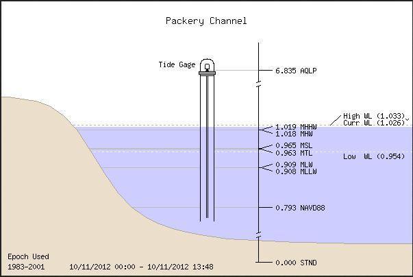
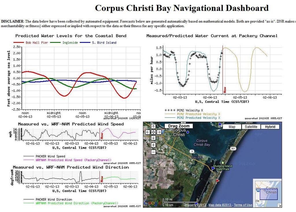
33 Water Level predictions: Measurements & Tidal Predictions for Packery Channel

34 Tide performance along the Texas coast ( ) CF (15 cm) Central Frequency of 15cm Frequency of predictions within 15cm of measurement
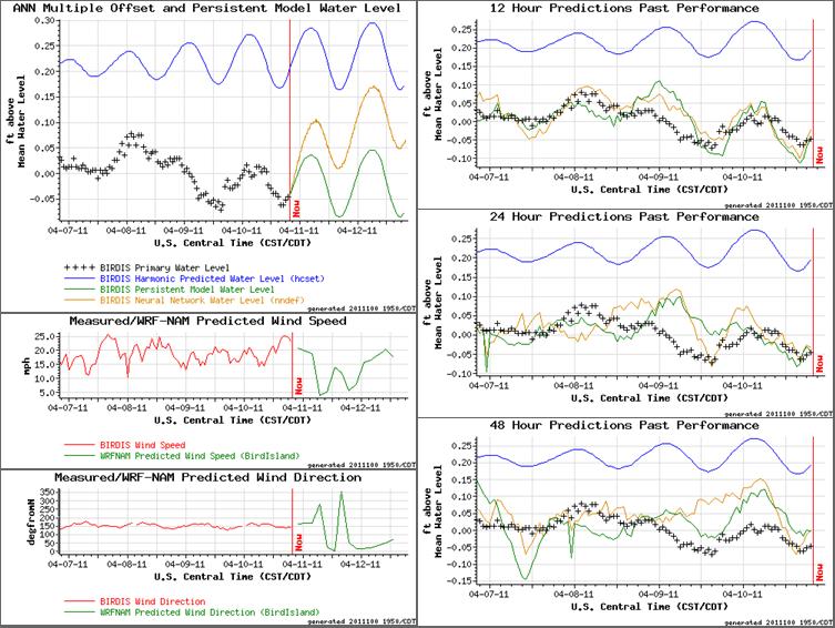
35 ANN Water Level Model Inputs: 0-48hrs past measurements: water levels, wind speeds, wind directions Tidal level predictions, wind predictions Atmospheric Predictions from North American Model, presently WFR-NAM, transmitted 4 times daily Models trained over 1 year of hourly data (selecting data sets with fronts and storms) Models optimized based on NOS criteria, mainly Central Frequency (15 cm)
36 Predictions for Packery Channel: 4/10/ :49 CST
37
38 Central Frequency CF (15 cm) Performance Analysis (CC Naval Air Station ) 102 % 100 % 98 % 96 % 94 % 92 % 90 % 88 % 86 % 84 % 82 % ANN with Wind Forecasts ANN without Wind Forecasts Persistent Model Tides CF(15 cm) = 90% Forecast Time [hrs] ANN inputs include Estuary and Coastal Measurements
![Surge [m] Water Levels [m] Error [m] Potential for Storm Surge Predictions](/docs-images/72/66262291/images/39-0.jpg "within Bays: Galveston Bay Ike Track Sept.")


39 Surge [m] Water Levels [m] Error [m] Potential for Storm Surge Predictions within Bays: Galveston Bay Ike Track Sept. 5 Sept 14 Manchester Predictions - ANN trained on 2006 data Hrs Predictions Hours Error vs. Prediction Time Prediction Time [hrs] Surge at Pleasure Pier / Manchester Manchester Pleasure Pier Time to Landing [hrs]
40 Acknowledgments The ANN water level prediction system was in part supported by grants from the NOAA s Coastal Management Program (CMP), the Sea Grant Technology Program, the NOAA Environmental Cooperative Science Center (ECSC) and the Texas Research evelopment Fund (TRF). The water temperature prediction system was in part funded by Texas Parks and Wildlife, the Coastal Conservation Association and NOAA Environmental Cooperative Science Center (ECSC). The Transit App was in part supported by NOAA ECSC & NOAA CO-OPS. The views expressed herein are those of the authors and do not necessarily reflect the views of sponsors.

41 In conclusion The began the development of the Texas Coastal Ocean Observation Network in Since it s inception, the TCOON has expanded, contracted, stations have been destroyed, and been rebuilt. As a result, data from 30 TCOON stations installed on Storm resistant, hardened structures. ata are available online and in near real-time. CBIs database archives all information and activities associated with each data collection station included in TCOON. For more information, visit:
Texas Coastal Ocean Observation Network. Richard Edwing Director, Center for Operational Oceanographic Products and Services November 2016
 Texas Coastal Ocean Observation Network Richard Edwing Director, Center for Operational Oceanographic Products and Services November 2016 What is CO-OPS? Meaningful oceanographic data for the Nation CO-OPS
Darren Wright Maritime Services Program Manager Center for Operational Oceanographic Products and Services (CO-OPS)
") Darren Wright Maritime Services Program Manager Center for Operational Oceanographic Products and Services (CO-OPS) Center for Operational Oceanographic Products and Services (CO-OPS) National Water Level
Darren Wright Maritime Services Program Manager Center for Operational Oceanographic Products and Services (CO-OPS) Center for Operational Oceanographic Products and Services (CO-OPS) National Water Level
NOAA s National Ocean Service. Center for Operational Oceanographic Products and Services
 NOAA s National Ocean Service Center for Operational Oceanographic Products and Services Richard Edwing, CO-OPS Acting Director January 27, 2010 Outline CO-OPS Overview Programs Observing Systems PORTS
Advancing Real Time Observations and Coastal Modeling Forecasts-
 Advancing Real Time Observations and Coastal Modeling Forecasts- Moving Forward in a Changing Coastal Landscape Next Generation Navigation-Coastal Operations- Coastal and Nearshore Coastal Operational
HFR Surface Currents Observing System in Lower Chesapeake Bay and Virginia Coast
 HFR Surface Currents Observing System in Lower Chesapeake Bay and Virginia Coast Larry P. Atkinson, Teresa Garner, and Jose Blanco Center for Coastal Physical Oceanography Old Dominion University Norfolk,
Water Level Prediction with Artificial Neural Network Models
 Water Level Prediction with Artificial Neural Network Models CARL STEIDLEY, ALEX SADOVSKI, PHILLIPE TISSOT, RAY BACHNAK, ZACK BOWLES Texas A&M University Corpus Christi 6300 Ocean Dr. Corpus Christi, TX
Coastal Response Research Center. Nancy Kinner University of New Hampshire (UNH) Michele Jacobi NOAA ORR. September 27, 2007
 Michele Jacobi NOAA ORR. September 27, 2007") Coastal Response Research Center Nancy Kinner University of New Hampshire (UNH) Michele Jacobi NOAA ORR September 27, 2007 1 Coastal Response Research Center (CRRC) CRRC is partnership between NOAA s Office
Coastal Response Research Center Nancy Kinner University of New Hampshire (UNH) Michele Jacobi NOAA ORR September 27, 2007 1 Coastal Response Research Center (CRRC) CRRC is partnership between NOAA s Office
Evaluation of Storm Tide Measurements at Panama City Beach, FL
 Evaluation of Storm Tide Measurements at Panama City Beach, FL 1993-2007 Prepared by Mark E. Leadon Beaches and Shores Resource Center Florida State University May 2009 Prepared for Florida Department
South Bay Coastal Ocean Observing System California Clean Beaches Initiative
 South Bay Coastal Ocean Observing System California Clean Beaches Initiative Third Quarterly Report April, 2003 to City of Imperial Beach Eric Terrill 1 1 Scripps Institution of Oceanography, University
The Coastal Field Data Collection Program (CFDC) Waves & Coastal Observations for the Corps and the Nation
 Waves & Coastal Observations for the Corps and the Nation") The Coastal Field Data Collection Program (CFDC) Waves & Coastal Observations for the Corps and the Nation Bill Birkemeier Program Manager William.Birkemeier@usace.army.mil 10 August 2010 US Army Corps
The Coastal Field Data Collection Program (CFDC) Waves & Coastal Observations for the Corps and the Nation Bill Birkemeier Program Manager William.Birkemeier@usace.army.mil 10 August 2010 US Army Corps
Overview of NOS Coastal Ocean Operational Forecast Systems
 Overview of NOS Coastal Ocean Operational Forecast Systems Aijun Zhang NOAA/NOS Center for Operational Oceanographic Products and Services (CO-OPS) Frank Aikman III NOAA/NOS/OCS Coast Survey Development
Environmental Response Management Application
 Environmental Response Management Application Coastal Response Research Center Nancy Kinner, Michele Jacobi, Rob Braswell, Kurt Schwehr & Amy Merten RRT III May 14, 2008 1 Talk Outline Overview of Center
THC-T-2013 Conference & Exhibition
 Modeling of Shutter Coastal Protection against Storm Surge for Galveston Bay C. Vipulanandan, Ph.D., P.E., Y. Jeannot Ahossin Guezo and and B. Basirat Texas Hurricane Center for Innovative Technology (THC-IT)
Evaluating Hydrodynamic Uncertainty in Oil Spill Modeling
 Evaluating Hydrodynamic Uncertainty in Oil Spill Modeling GIS in Water Resources (CE 394K) Term Project Fall 2011 Written by Xianlong Hou December 1, 2011 Table of contents: Introduction Methods: Data
SAWS: Met-Ocean Data & Infrastructure in Support of Industry, Research & Public Good. South Africa-Norway Science Week, 2016
 SAWS: Met-Ocean Data & Infrastructure in Support of Industry, Research & Public Good South Africa-Norway Science Week, 2016 Marc de Vos, November 2016 South Africa: Context http://learn.mindset.co.za/sites/default/files/resourcelib/e
John Callahan (Delaware Geological Survey) Kevin Brinson, Daniel Leathers, Linden Wolf (Delaware Environmental Observing System)
 Kevin Brinson, Daniel Leathers, Linden Wolf (Delaware Environmental Observing System)") John Callahan (Delaware Geological Survey) Kevin Brinson, Daniel Leathers, Linden Wolf (Delaware Environmental Observing System) Delaware is extremely vulnerable to the impacts of coastal flooding Tropical
John Callahan (Delaware Geological Survey) Kevin Brinson, Daniel Leathers, Linden Wolf (Delaware Environmental Observing System) Delaware is extremely vulnerable to the impacts of coastal flooding Tropical
Material Workshop. Galveston District 2012 Beneficial Use of Dredged. Material Workshop. Custodians of the Coast
 Galveston District 2012 Beneficial Use of Dredged Material Workshop Galveston District 2012 Beneficial Use of Dredged Material Workshop US Army Corps of Engineers BUILDING STRONG Welcome Opening Remarks
University of New Hampshire Scholars' Repository
 University of New Hampshire University of New Hampshire Scholars' Repository Center for Coastal and Ocean Mapping Center for Coastal and Ocean Mapping 3-2009 Environmental Response Management Application
Preliminary Vulnerability Assessment of Coastal Flooding Threats - Taylor County, Florida
 Preliminary Vulnerability Assessment of Coastal Flooding Threats - Taylor County, Florida North Central Florida Regional Planning Council Northeast Florida Regional Council April 28, 2016 BACKGROUND This
3.2 OPTIMIZATION AND PERFORMANCE OF A NEURAL NETWORK MODEL FORECASTING WATER LEVELS FOR THE CORPUS CHRISTI, TEXAS, ESTUARY
 3.2 OPTIMIZATION AND PERFORMANCE OF A NEURAL NETWORK MODEL FORECASTING WATER LEVELS FOR THE CORPUS CHRISTI, TEXAS, ESTUARY Philippe E. Tissot, and Patrick R. Michaud Conrad Blucher Institute, Texas A&M
HURRICANE IVAN CHARACTERISTICS and STORM TIDE EVALUATION
 HURRICANE IVAN CHARACTERISTICS and STORM TIDE EVALUATION By Robert Wang and Michael Manausa Sponsored by Florida Department of Environmental Protection, Bureau of Beaches and Coastal Systems Submitted
PROJECT DESCRIPTION. 1. Introduction Problem Statement
 Salmun, H: A proposal submitted to PSC-CUNY program on October 15, 2009. Statistical prediction of storm surge associated with East Coast Cool-weather Storms at The Battery, New York. Principal Investigator:
FOURTH INTERNATIONAL PORT METEOROLOGICAL OFFICERS WORKSHOP AND SUPPORT TO GLOBAL OCEAN OBSERVATIONS USING SHIP LOGISTICS
 FOURTH INTERNATIONAL PORT METEOROLOGICAL OFFICERS WORKSHOP AND SUPPORT TO GLOBAL OCEAN OBSERVATIONS USING SHIP LOGISTICS PMO-IV 8-10 DEC 2010, ORLANDO, FLORIDA, USA 1 This presentation is generally for
The Kentucky Mesonet: Entering a New Phase
 The Kentucky Mesonet: Entering a New Phase Stuart A. Foster State Climatologist Kentucky Climate Center Western Kentucky University KCJEA Winter Conference Lexington, Kentucky February 9, 2017 Kentucky
Earth Wind & Fire. Game Changing Restoration Options in the Texas Chenier Plain
 Earth Wind & Fire Game Changing Restoration Options in the Texas Chenier Plain EARTH: The Chenier Plain is a 5 million acre coastal region in Southwest Louisiana and Southeast Texas providing landscape
Regional Sediment Management
 Regional Sediment Management Linda S. Lillycrop Program Manager Coastal Engineer US Army Engineer Research and Development Center Coastal and Hydraulics Laboratory Q AVG Coastal Resilience: The Environmental,
Data Management for Algal Monitoring in the Gulf of Mexico
 Data Management for Algal Monitoring in the Gulf of Mexico Scott Cross NOAA National Oceanographic Data Center/ Coastal Data Development Center (NCDDC) Outline History Current & Future Directions Needs
COASTAL DATA APPLICATION
 2015 Coastal GeoTools Proactive By Design. Our Company Commitment COASTAL DATA APPLICATION Projecting Future Coastal Flood Risk for Massachusetts Bay Bin Wang, Tianyi Liu, Daniel Stapleton & Michael Mobile
Title: NOAA National Ocean Service Response Team efforts during the 2004 Hurricane Season
 Title: NOAA National Ocean Service Response Team efforts during the 2004 Hurricane Season LCDR Rick Fletcher, OCS/NOS/NOAA Abstract: The 2004 Atlantic Hurricane Season has been one of the most active and
HURRICANE FRANCES CHARACTERISTICS and STORM TIDE EVALUATION
 HURRICANE FRANCES CHARACTERISTICS and STORM TIDE EVALUATION ((DRAFT)) By Robert Wang and Michael Manausa Sponsored by Florida Department of Environmental Protection, Bureau of Beaches and Coastal Systems
Preliminary Results from Coordinated Sea-Level Rise Modeling Using SLAMM, the Sea Level Affecting Marshes Model, Across the US Gulf of Mexico Coast
 Preliminary Results from Coordinated Sea-Level Rise Modeling Using SLAMM, the Sea Level Affecting Marshes Model, Across the US Gulf of Mexico Coast James W. Pahl, Ph.D., and Kristin DeMarco, State of Louisiana
3.4 HYDRODYNAMIC MODELING OF ENGINEERED INLET AND CANAL EXTENSION
 3.4 HYDRODYNAMIC MODELING OF ENGINEERED INLET AND CANAL EXTENSION Larry Dell, Philippe E. Tissot, Deidre Williams, Bradley Koskowich, and Niall Durham Conrad Blucher Institute, Texas A&M University-Corpus
2006 & 2007 Pre-Hurricane Scenario Analyses
 2006 & 2007 Pre-Hurricane Scenario Analyses Executive Summary May 2007 Page 1 OF X FOR OFFICIAL USE ONLY 4 Public Availability to be Determined Under 5 U.S.C. 552 NOTE: Limited Distribution. Release of
New NASA Ocean Observations and Coastal Applications
 New NASA Ocean Observations and Coastal Applications Duane Armstrong Chief, Applied Science & Technology Project Office August 20, 2014 1 Outline NASA s new Earth Science Ocean Science Missions for 2014
Hurricane Protection and Environmental Restoration
 November 16, 2010 Hurricane Protection and Environmental Restoration Presented by: Colonel (Ret.) Leonard Waterworth AGENDA How do we protect People/Environment/Economy 1900 Year Storm Hurricane Carla
West Florida Shelf and Tampa Bay Responses to Hurricane Irma: What Happened and Why
 West Florida Shelf and Tampa Bay Responses to Hurricane Irma: What Happened and Why R.H. Weisberg Y. Liu J. Chen College of Marine Science University of South Florida St. Petersburg, FL SECOORA Webinar
Coastal and Hydraulics Laboratory
 ERDC/CHL TR-05-6 Texas City Ship Channel Deepening Study, Hydrodynamic Model Lisa M. Lee, Jennifer N. Tate, and R. C. Berger August 2005 Coastal and Hydraulics Laboratory Approved for public release; distribution
Hindcast Arabian Gulf
 Hindcast Arabian Gulf Image of isobars of atmospheric pressure and hindcast wind- and wave field over the Arabian Gulf during a storm in January 1993. Detailed wave studies are supported by nesting of
Hurricane Season 2010 & NOAA s Deepwater Response
 Hurricane Season 2010 & NOAA s Deepwater Response What s Happened? What Will 2010 Bring? Possible Shoreline Effects Darin Figurskey Meteorologist-in-Charge NOAA s NWS Raleigh, NC NOAA s National Weather
South Bay Coastal Ocean Observing System California Clean Beaches Initiative
 South Bay Coastal Ocean Observing System California Clean Beaches Initiative Second Quarterly Report January, 2003 to City of Imperial Beach Eric Terrill 1 1 Scripps Institution of Oceanography, University
NWS Operational Marine and Ocean Forecasting. Overview. Ming Ji. Ocean Prediction Center National Weather Service/NCEP. CIOSS/CoRP
 NWS Operational Marine and Ocean Forecasting Overview Ming Ji Ocean Prediction Center National Weather Service/NCEP CIOSS/CoRP CoRP Symposium Corvallis, OR Aug. 12-13, 13, 2008 Titanic Telegram Marine
Frank Revitte National Weather Service. Weather Forecast Office New Orleans/Baton Rouge
 Frank Revitte National Weather Service Weather Forecast Office New Orleans/Baton Rouge Above normal activity 17 Total Named Storms 7 Tropical Storms 4 Hurricanes 6 Major Hurricanes Not the most active,
WMO Guide on Integrated Urban Weather, Environment and Climate Services for Cities (IUWECS) Hong Kong- an experience from a high-density city
 Hong Kong- an experience from a high-density city") WMO Guide on Integrated Urban Weather, Environment and Climate Services for Cities (IUWECS) Hong Kong- an experience from a high-density city Dr. Chao REN Associate Professor School of Architecture The
WMO Guide on Integrated Urban Weather, Environment and Climate Services for Cities (IUWECS) Hong Kong- an experience from a high-density city Dr. Chao REN Associate Professor School of Architecture The
Add NOAA nowcoast Layers to Maps
 WebEOC Maps Add-on Quick Reference Guide Add NOAA nowcoast Layers to Maps Overview With Maps Add-on, you can configure an unlimited number of map layers. These layers allow you to control the data you
Quantifying effects of oil on coastal dune vegetation. Thomas Miller and Elise Gornish Biological Science, Florida State University
 Quantifying effects of oil on coastal dune vegetation Thomas Miller and Elise Gornish Biological Science, Florida State University Natural History of Barrier Islands in the Northern Gulf Make up ~70% of
Analysis of Tides and Storm Surge from Observational Records in the Delaware Inland Bays
 Analysis of Tides and Storm Surge from Observational Records in the Delaware Inland Bays John Callahan Delaware Geological Survey Coastal GeoTools Conference March 30 April 2, 2015 Charleston, SC Outline
5/25/2017. What is projected for Coastal texas? PROTECTING CRITICAL WATER INFRASTRUCTURE FROM SEA LEVEL RISE
 PROTECTING CRITICAL WATER INFRASTRUCTURE FROM SEA LEVEL RISE What is projected for Coastal texas? Mean Sea Level has risen 3 18 to 37 above Mean Sea Level 1800-1992 1992-2015 2030 2060 2100 Mean Sea Level
JCOMM-CHy Coastal Inundation Forecasting Demonstration Project (CIFDP)
") WMO World Meteorological Organization Working together in weather, climate and water JCOMM-CHy Coastal Inundation Forecasting Demonstration Project (CIFDP) Coastal Flooding & Vulnerable Populations Coastal
WMO World Meteorological Organization Working together in weather, climate and water JCOMM-CHy Coastal Inundation Forecasting Demonstration Project (CIFDP) Coastal Flooding & Vulnerable Populations Coastal
Comparative Analysis of Hurricane Vulnerability in New Orleans and Baton Rouge. Dr. Marc Levitan LSU Hurricane Center. April 2003
 Comparative Analysis of Hurricane Vulnerability in New Orleans and Baton Rouge Dr. Marc Levitan LSU Hurricane Center April 2003 In order to compare hurricane vulnerability of facilities located in different
Simulation of storm surge and overland flows using geographical information system applications
 Coastal Processes 97 Simulation of storm surge and overland flows using geographical information system applications S. Aliabadi, M. Akbar & R. Patel Northrop Grumman Center for High Performance Computing
DIVISION OF COASTAL MANAGEMENT TO STUDY CURRENT LONG-TERM EROSION RATES ADJACENT TO TERMINAL GROINS
 DIVISION OF COASTAL MANAGEMENT TO STUDY CURRENT LONG-TERM EROSION RATES ADJACENT TO TERMINAL GROINS North Carolina Department of Environmental Quality Division of Coastal Management February 22, 2018 N.
NOAA Surface Weather Program
 NOAA Surface Weather Program Maintenance Decision Support System Stakeholder Meeting #9 Jim O Sullivan NOAA Surface Weather Program Manager NWS Office of Climate, Water, and Weather Services September
Monitoring Hurricane Rita Inland Storm Surge
 Monitoring Hurricane Rita Inland Storm Surge By Benton D. McGee, Roland W. Tollett, and Burl B. Goree Pressure transducers (sensors) are accurate, reliable, and cost-effective tools to measure and record
Forecast of Nearshore Wave Parameters Using MIKE-21 Spectral Wave Model
 Forecast of Nearshore Wave Parameters Using MIKE-21 Spectral Wave Model Felix Jose 1 and Gregory W. Stone 2 1 Coastal Studies Institute, Louisiana State University, Baton Rouge, LA 70803 2 Coastal Studies
NOAA S Arctic Program in 2017
 NOAA S Arctic Program in 2017 NOAA s Arctic Mission To determine how the Arctic system is changing on time scales of weeks to decades, particularly with respect to the consequences that the loss of sea
Visualizing hurricanes
 Visualizing hurricanes NAME: DATE: Scientific visualization is an integral part of the process of simulating natural phenomena. In the computational sciences, the main goal is to understand the workings
Storm Surge Analysis Update Meeting Cross City, Florida June 17, 2014
 Big Bend Coastal Storm Surge Study Storm Surge Analysis Update Meeting Cross City, Florida June 17, 2014 Introductions Risk MAP Project Team FEMA Region IV Florida Division of Emergency Management (FDEM)
Contribution of Norwegian partners (Aanderaa Data Instruments and NIVA) to Safeport project ( ). Final report
 to Safeport project ( ). Final report") Contribution of Norwegian partners (Aanderaa Data Instruments and NIVA) to Safeport project (2010-2012). Final report NFR-196866 Entry and Berthing Ship and Port Advising System as an Element of Port ITS.
Contribution of Norwegian partners (Aanderaa Data Instruments and NIVA) to Safeport project (2010-2012). Final report NFR-196866 Entry and Berthing Ship and Port Advising System as an Element of Port ITS.
The Delaware Environmental Monitoring & Analysis Center
 The Delaware Environmental Monitoring & Analysis Center Tina Callahan Delaware Estuary Science & Environmental Summit 2013 January 27-30, 2013 What is DEMAC? Delaware Environmental Monitoring & Analysis
Tracking Storm Tide and Coastal Flooding During Hurricane Matthew
 Tracking Storm Tide and Coastal Flooding During Hurricane Matthew Stephen Harden, Jeanne Robbins, and Eric Frantz U.S. Geological Survey, South Atlantic Water Science Center Presented to: WRRI Annual Conference
Access to IOOS Data Relevant to OOI. Kathleen Bailey NOAA/NOS/IOOS January 6, 2016
 Access to IOOS Data Relevant to OOI Kathleen Bailey NOAA/NOS/IOOS January 6, 2016 The U.S. Integrated Ocean Observing System (IOOS) Federal Regional Satellites 600+: Buoys, Water Level stations, Coastal
The Field Research Facility, Duck, NC Warming Ocean Observations and Forecast of Effects
 The Field Research Facility, Duck, NC Warming Ocean Observations and Forecast of Effects A potential consequence of a warming ocean is more frequent and more intense wind events (Hurricanes & Typhoons)
NORTHEAST COASTAL OCEAN FORECAST SYSTEM (NECOFS)
") NORTHEAST COASTAL OCEAN FORECAST SYSTEM (NECOFS) R. C. Beardsley and C. Chen MITSG 13-27 Sea Grant College Program Massachusetts Institute of Technology Cambridge, Massachusetts 02139 NOAA Grant No. NA10OAR4170086
NORTHEAST COASTAL OCEAN FORECAST SYSTEM (NECOFS) R. C. Beardsley and C. Chen MITSG 13-27 Sea Grant College Program Massachusetts Institute of Technology Cambridge, Massachusetts 02139 NOAA Grant No. NA10OAR4170086
Maritime Weather Information: Automatic Reporting, A New Paradigm
 Maritime Weather Information: Automatic Reporting, A New Paradigm Joe Sienkiewicz, NOAA/NWS Ocean Prediction Center Responsibilities under SOLAS Met Services Contracting governments Observations Limited
CLIMATE CHANGE ADAPTATION BY MEANS OF PUBLIC PRIVATE PARTNERSHIP TO ESTABLISH EARLY WARNING SYSTEM
 CLIMATE CHANGE ADAPTATION BY MEANS OF PUBLIC PRIVATE PARTNERSHIP TO ESTABLISH EARLY WARNING SYSTEM By: Dr Mamadou Lamine BAH, National Director Direction Nationale de la Meteorologie (DNM), Guinea President,
Alaska Ocean Observing System 101 Anchorage, Alaska
 Alaska Ocean Observing System 101 Anchorage, Alaska Molly McCammon, Director Alaska Ocean Observing System (AOOS) A Regional Observing System within the Integrated Ocean Observing System www.aoos.org IOOS
Great Lakes Information Network GIS (Queryable by topic, geography, organization, and upload date 73 layers as of October, 2009)
") Google Earth Files for the Great Lakes and Beyond GLOS Mapping Workshop Alpena, Michigan November 9, 2009 David Hart GIS Specialist University of Wisconsin Sea Grant Institute GREAT LAKES Great Lakes Information
Google Earth Files for the Great Lakes and Beyond GLOS Mapping Workshop Alpena, Michigan November 9, 2009 David Hart GIS Specialist University of Wisconsin Sea Grant Institute GREAT LAKES Great Lakes Information
Hurricane Harvey: SE Texas Impacts. 10 PM CDT UPDATE Friday, August 25, 2017 Prepared by: Lance Wood
 Hurricane Harvey: SE Texas Impacts 10 PM CDT UPDATE Friday, August 25, 2017 Prepared by: Lance Wood Latest Observations Hurricane Harvey making landfall this evening near Rockport as a category 4 hurricane.
CHAPTER 13 WEATHER ANALYSIS AND FORECASTING MULTIPLE CHOICE QUESTIONS
 CHAPTER 13 WEATHER ANALYSIS AND FORECASTING MULTIPLE CHOICE QUESTIONS 1. The atmosphere is a continuous fluid that envelops the globe, so that weather observation, analysis, and forecasting require international
Applied Geoscience and Technology Division SOPAC. Joy Papao, Risk Information Systems Officer
 Joy Papao, Risk Information Systems Officer Secretariat of the Pacific Community SPC 22 Pacific Island States Head office in Noumea, New Caledonia 2 Regional offices (Pohnpei and Honiara) 600 staff 9 Technical
Charles Magori. Status Report of GLOSS Tide Gauges in Kenya
 GLOSS Group of Experts Meeting February 2005 Charles Magori Introduction Status Report of GLOSS Tide Gauges in Kenya There is growing concern about the rise in mean sea level around the globe. To address
Sunset Harbour / Huntington Harbour Maintenance Dredging and Waterline Installation Project. CMANC 21 January 2016
 Sunset Harbour / Huntington Harbour Maintenance Dredging and Waterline Installation Project CMANC 21 January 2016 County of Orange Footprint Huntington Harbour Operational and Dredging Cost Sharing Agreements
The National Weather Service of the Future: Building a Weather-Ready Nation
 The of the Future: Building a Weather-Ready Nation Dr. Louis W. Uccellini Director, NOAA Assistant Administrator for Weather Services NCEP Production Suite Review December 2, 2014 Outline Building a Weather-Ready
ALASKA OCEAN OBSERVING SYSTEM 2016 ANNUAL IMPACT REPORT
 ALASKA OCEAN OBSERVING SYSTEM 2016 ANNUAL IMPACT REPORT 1 ALASKA OCEAN OBSERVING SYSTEM 2016 ANNUAL IMPACT REPORT 2 ALASKA OCEAN OBSERVING SYSTEM 2016 ANNUAL IMPACT REPORT Letter from Executive Director
CHAPTER 123 ANALYSIS OF HURRICANE TIDES AT PADRE ISLAND, TEXAS ABSTRACT
 CHAPTER 123 ANALYSIS OF HURRICANE TIDES AT PADRE ISLAND, TEXAS Frank D Masch 1, Robert! Brandes 2, Floyd R Hill 3 and William A White 4 ABSTRACT To establish design data, a study was undertaken to determine
NOAA Nautical Charts and Coastal and Marine Spatial Planning. Meredith Westington Chief Geographer NOAA/NOS/Office of Coast Survey
 NOAA Nautical Charts and Coastal and Marine Spatial Planning Meredith Westington Chief Geographer NOAA/NOS/Office of Coast Survey Ocean Policy Task Force What is CMSP? A comprehensive, adaptive, integrated,
NOAA Inundation Dashboard
 NOAA Inundation Dashboard Audra Luscher & Paul Fanelli NOS Center for Operational Oceanographic Products & Services (CO-OPS) Hampton Roads Sea Level Rise/Flooding Adaptation Forum July 29, 2016 http://tidesandcurrents.noaa.gov/inundationdb/newyork.html
North Atlantic Coast Comprehensive Study (NACCS) APPENDIX A: ENGINEERING
 APPENDIX A: ENGINEERING") North Atlantic Coast Comprehensive Study (NACCS) APPENDIX A: ENGINEERING NORTH ATLANTIC COAST COMPREHENSIVE STUDY: RESILIENT ADAPTATION TO INCREASING RISK Appendix A - Engineering Table of Contents North
North Atlantic Coast Comprehensive Study (NACCS) APPENDIX A: ENGINEERING NORTH ATLANTIC COAST COMPREHENSIVE STUDY: RESILIENT ADAPTATION TO INCREASING RISK Appendix A - Engineering Table of Contents North
Red de Observacion del Nivel del Mar para America Central (RONMAC)
") Red de Observacion del Nivel del Mar para America Central (RONMAC) Guatemala Reconnaissance Report Monday, June 19, 2000 Began with a meeting at Instituto Nacional de Sismologia Vulcanologia Meteorologia
Red de Observacion del Nivel del Mar para America Central (RONMAC) Guatemala Reconnaissance Report Monday, June 19, 2000 Began with a meeting at Instituto Nacional de Sismologia Vulcanologia Meteorologia
Operational Estuarine & Coastal Forecast Systems in NOAA s. National Ocean Service
 Operational Estuarine & Coastal Forecast Systems in NOAA s. National Ocean Service Eugene Wei, Frank Aikman III and Richard Patchen NOAA S S National Ocean Service Workshop on: Data Assimilation in Support
THAILAND NATIONAL REPORT
 NIOHC18 TH National Report THAILAND NATIONAL REPORT 18 th NORTH INDIAN OCEAN HYDROGRAPHIC COMMISSION (NIOHC) CONFERENCE Goa, India 9 th 12 th April 2018-1 - CONTENTS 1. Hydrographic Office / Service 3
Observing System Requirements for the Harmful Algal Bloom Forecast System in the Gulf of Mexico
 Observing System Requirements for the Harmful Algal Bloom Forecast System in the Gulf of Mexico July 2007 Background The Harmful Algal Bloom (HAB) Forecast System provides nowcasts and forecasts of Karenia
Assessing Storm Tide Hazard for the North-West Coast of Australia using an Integrated High-Resolution Model System
 Assessing Storm Tide Hazard for the North-West Coast of Australia using an Integrated High-Resolution Model System J. Churchill, D. Taylor, J. Burston, J. Dent September 14, 2017, Presenter Jim Churchill
Getting Smarter. E-Navigation Report, Atlantic: Presentation to SFC Mariners Workshop January 27, 2016
 E-Navigation Report, Atlantic: Getting Smarter Presentation to SFC Mariners Workshop January 27, 2016 By: Capt. Andrew Rae, VP Atlantic Canadian Marine Pilots Association E-Navigation initiatives in Atlantic
Who cares about S2S research to improve forecasts?
 Who cares about S2S research to improve forecasts? Ali Stevens, Annarita Mariotti, Dan Barrie, Emily Read Climate Program Office Contact: alison.stevens@noaa.gov 16th Annual CPASW May 22-24, 2018 **Any
Great Lakes Regional Collaboration and U.S. GEOSS/IOOS/GLOS Initiative Focus on the Huron to Erie Corridor
 Great Lakes Regional Collaboration and U.S. GEOSS/IOOS/GLOS Initiative Focus on the Huron to Erie Corridor USEPA Grosse Ile Lab October 17, 2005 Great Lakes Interagency Task Force Draft Plan calls for
Sea Level Space Watch: Service Offering
 Space for Smarter Government Programme Sea Level Space Watch: Service Offering General Sea Level Space Watch : Operational service developed to support national flood defence planning. Systematically updated
Eastern Shore Weather and Climate. Bill Sammler Warning Coordination Meteorologist National Weather Service Wakefield, VA
 Eastern Shore Weather and Climate Bill Sammler Warning Coordination Meteorologist National Weather Service Wakefield, VA About The NWS The National Weather Service is: A Federal Government Agency Part
Alexandra Carvalho, Ph.D., GISP Kathy Fitzpatrick, P.E.
 Coastal Data Organization for Project Management and Coastal Planning Martin County, Florida Alexandra Carvalho, Ph.D., GISP Kathy Fitzpatrick, P.E. Outline County Coastal Programs Coastal Geodatabase
National / Naval Ice Center (NIC) Operations Brief This brief is UNCLASSIFIED
 Operations Brief This brief is UNCLASSIFIED") National / Naval Ice Center (NIC) Operations Brief This brief is UNCLASSIFIED Christopher Szorc, Senior Ice Analyst/Forecaster USCG USN NOAA Outline NIC s mission is to provide timely, accurate and relevant
National / Naval Ice Center (NIC) Operations Brief This brief is UNCLASSIFIED Christopher Szorc, Senior Ice Analyst/Forecaster USCG USN NOAA Outline NIC s mission is to provide timely, accurate and relevant
North Slope Trends in Sea Level, Storm Frequency, Duration and Intensity
 North Slope Trends in Sea Level, Storm Frequency, Duration and Intensity Nels J. Sultan, Kenton W. Braun and Dempsey S. Thieman PND Engineers, Inc. Anchorage, Alaska, USA nsultan@pndengineers.com ABSTRACT
Adaptation to Sea Level Rise A Regional Approach
 Adaptation to Sea Level Rise A Regional Approach Project Partners: in Saco Bay, ME Peter Slovinsky, Marine Geologist Maine Geological Survey, Department of Conservation Project Funding from: Saco Bay Hazards
NOAA Arctic Priorities and Potential Contributions to PPP/YOPP. Randall Dole NOAA Earth System Research Laboratory Physical Sciences Division
 NOAA Arctic Priorities and Potential Contributions to PPP/YOPP Randall Dole NOAA Earth System Research Laboratory Physical Sciences Division 1 NOAA s Arctic Goals Forecast Sea Ice Strengthen Foundational
AND THE COOPERATION WITH SENTINEL ASIA FOR DISASTER MANAGEMENT
 Ministry of Natural resources and Environment National Remote Sensing DEpartment NATIONAL REMOTE SENSING DEPARTMENT (NRSD) AND THE COOPERATION WITH SENTINEL ASIA FOR DISASTER MANAGEMENT By: Dr. Chu Hai
PUBLIC SAFETY POWER SHUTOFF POLICIES AND PROCEDURES
 PACIFIC GAS AND ELECTRIC COMPANY PUBLIC SAFETY POWER SHUTOFF POLICIES AND PROCEDURES SEPTEMBER 2018 1 PACIFIC GAS AND ELECTRIC COMPANY PUBLIC SAFETY POWER SHUTOFF POLICIES AND PROCEDURES SEPTEMBER 2018
Coastal Barrier Island Network (CBIN): Management strategies for the future
: Management strategies for the future") Coastal Barrier Island Network (CBIN): Management strategies for the future Heather Joesting*, Amy Williams**, Rusty Feagin**, and William K. Smith* *Department of Biology, Wake Forest University, Winston
Coastal Barrier Island Network (CBIN): Management strategies for the future Heather Joesting*, Amy Williams**, Rusty Feagin**, and William K. Smith* *Department of Biology, Wake Forest University, Winston
U.S. ARMY CORPS OF ENGINEERS
 CORPS FACTS Regulating Mississippi River Navigation Pools U.S. ARMY CORPS OF ENGINEERS BUILDING STRONG Historical Background Federal improvements in the interest of navigation on the Mississippi River
Savannah Harbor Expansion Project
 Savannah Harbor Expansion Project Evaluation of Hurricane Surge Impacts with Proposed Mitigation Plan December 2007 Introduction This report summarizes the results of hurricane surge impacts with implementation
Environmental Data In Support of Search & Rescue Operations in the Central Mediterranean Sea
 Environmental Data In Support of Search & Rescue Operations in the Central Mediterranean Sea Dr. Eric Comerma (RPS ASA) eric.comerma@rpsgroup.com Cathleen Turner (RPS ASA) Prof. Aldo Drago (Univ. of Malta)
The National Data Buoy Center: Strategic Ocean Observations and International Collaboration
 2011 International Union of Geodesy and Geophysics General Assembly July 1, 2011 The National Data Buoy Center: Strategic Ocean Observations and International Collaboration William Burnett, Richard Bouchard,