Darren Wright Maritime Services Program Manager Center for Operational Oceanographic Products and Services (CO-OPS)
|
|
|
- Job Lee
- 5 years ago
- Views:
Transcription

1 Darren Wright Maritime Services Program Manager Center for Operational Oceanographic Products and Services (CO-OPS)
")
 Water level, wind")


2 Center for Operational Oceanographic Products and Services (CO-OPS) National Water Level Observation Network (NWLON) Water level, wind speed and direction, barometric pressure, air and water temperature, conductivity Short-term water level station deployments 210 NWLON Stations National Current Observations Program Short-term current meter deployments (~70 sites a year)
3

4 Lower Columbia River PORTS

5 Why Do You Need PORTS? USS New York Under Huey Long Bridge
6 Safety? More Cargo?

7 The greatest safety concern is the availability of timely, accurate, and reliable navigation information MTS Report to Congress Larger vessels in small channels Zero tolerance for error NOAA
8 PORTS PORTS is a NOAA program that provides: Accurate real-time information to improve safety Avoided groundings Safer vessel maneuvers Efficiency of maritime commerce Increased cargo Reduced delays Improved SAR performance Environmental Protection and Planning Assistance Improved hazardous material response Improved environmental restoration activities
9 PORTS Recreational Planning Assistance Boating decisions Fishing decisions Beach visit decisions Improved Forecasts Marine weather forecasts Storm surge forecasts Scientific and Educational Information Scientific research Secondary education


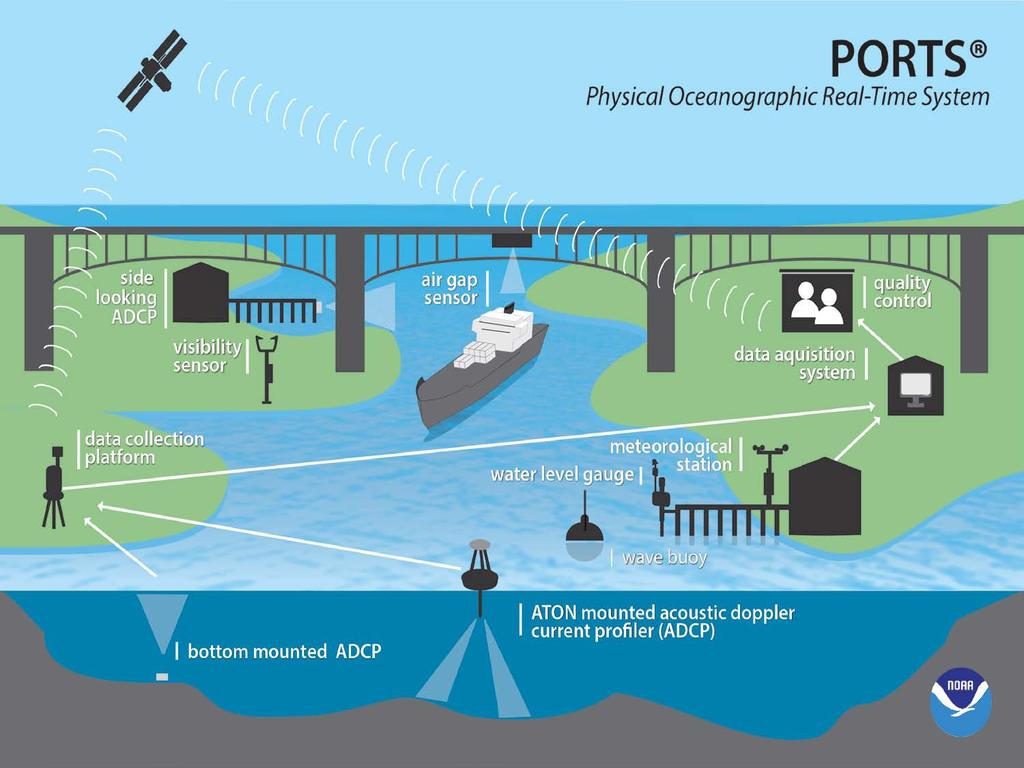
10 PORTS PROVIDES Graphical Display Observed and Predicted Water Levels Currents Meteorological Wind Speed/Direction Barometric Pressure Air/Water temperature Visibility (Fog) By Phone Bridge Air Gap Salinity Waves ALL DATA QA/QC d 24/7, 365 Text Display

11 PORTS Graphics Philadelphia

12 PORTS Voice System Good afternoon you have reached the port of real-time system called PORTS. For Current Data Press #1 For Water Levels Press #2 For Meteorological Data Press #3 For Salinity Data Press #4 NY/NJ PORTS PORTS Tampa PORTS TB -PORTS H/G PORTS 866- HG -PORTS Columbia River PORTS Chesapeake Bay 866- CH -PORTS Narragansett Bay PORTS Port of Anchorage 866- AK -PORTS Delaware R&B


13 MOBILE PORTS Text Screen


14 ARNS Automated Real-time Narrative Summary
15

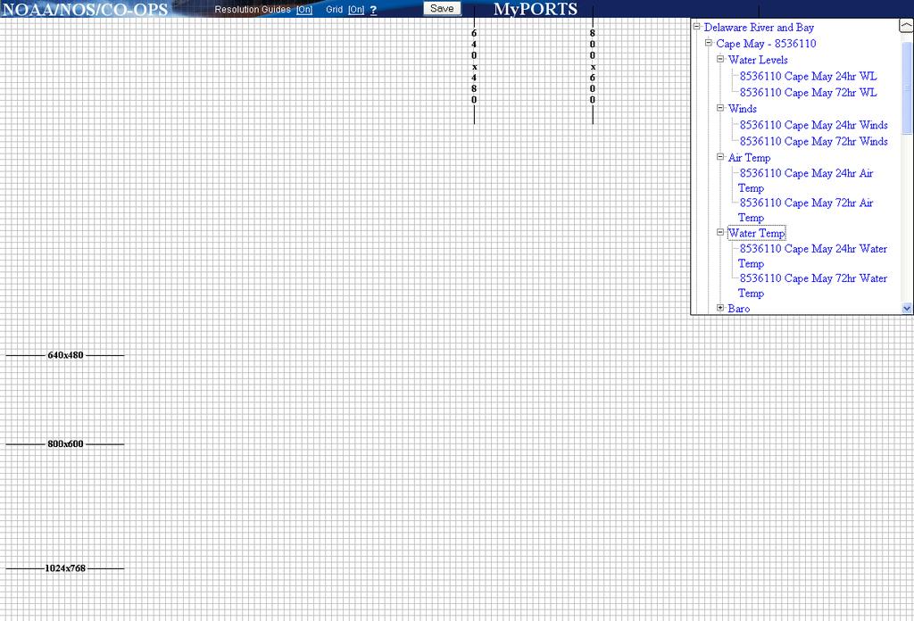
16 MyPORTS (Build your own pages)

17 PORTS Partnership Program PORTS is a partnership with responsibility shared between NOAA and the local maritime community. NOAA Program management Data collection and infrastructure Data dissemination 24/7 quality control National standards Development for future enhancements Partner Site selection for a userdefined system Funding for local: o Equipment o Installation o Annual operation o Maintenance

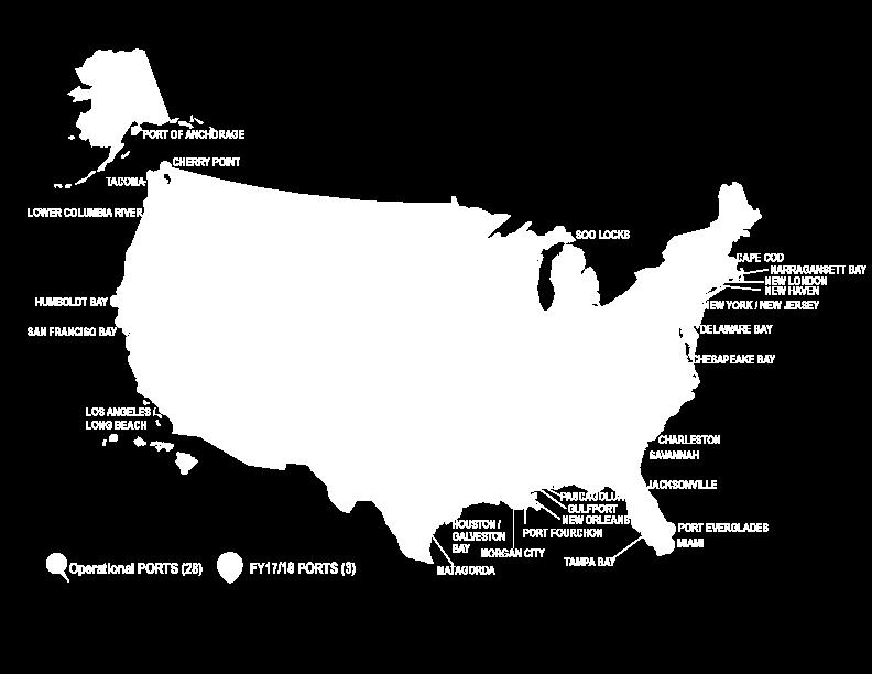
18 PORTS Locations

19 INCREASED SAFETY

20 Estimated Economic Benefits of a Fully-Built National PORTS System


21 Operational Forecast System Network of 13 Operational Nowcast and Forecast Hydrodynamic Model Systems Chesapeake Bay Delaware Bay New York and New Jersey St. John s River Tampa Bay Northern Gulf Columbia River San Francisco Lake Erie Lake Huron Lake Michigan Lake Ontario Lake Superior Winds WL Temp. Salinity Currents


22 Columbia River Estuary Operational Forecast System (CREOFS)
23 Operational Forecast System Water level nowcasts and forecast guidance Observed water level Forecast guidance: water level Nowcast water level
24 Using PORTS Data LOADMAX developed from a partnership between the Port of Portland and NWS NW River Forecast Office

25 LOADMAX Animation

26 Transmitting PORTS Data Through Coast Guard s Automatic Identification System (AIS)

27 Using PORTS Data
28 Useful URL s CO-OPS Main Website PORTS Page MyPORTS Mobile PORTS Columbia River Estuary Operational Forecast System

29 Thank you! Darren Wright PORTS URL
Advancing Real Time Observations and Coastal Modeling Forecasts-
 Advancing Real Time Observations and Coastal Modeling Forecasts- Moving Forward in a Changing Coastal Landscape Next Generation Navigation-Coastal Operations- Coastal and Nearshore Coastal Operational
NOAA s National Ocean Service. Center for Operational Oceanographic Products and Services
 NOAA s National Ocean Service Center for Operational Oceanographic Products and Services Richard Edwing, CO-OPS Acting Director January 27, 2010 Outline CO-OPS Overview Programs Observing Systems PORTS
Texas Coastal Ocean Observation Network. Richard Edwing Director, Center for Operational Oceanographic Products and Services November 2016
 Texas Coastal Ocean Observation Network Richard Edwing Director, Center for Operational Oceanographic Products and Services November 2016 What is CO-OPS? Meaningful oceanographic data for the Nation CO-OPS
Conrad Blucher Institute for Surveying and Science
 d James Rizzo Assistant irector of Operations - Office: 361-825-5758 Mobile: 361-549-5120 james.rizzo@tamucc.edu d d Texas Coastal Ocean Observation N Network (TCOON) Began in 1988 with 2 stations in Bay
Overview of NOS Coastal Ocean Operational Forecast Systems
 Overview of NOS Coastal Ocean Operational Forecast Systems Aijun Zhang NOAA/NOS Center for Operational Oceanographic Products and Services (CO-OPS) Frank Aikman III NOAA/NOS/OCS Coast Survey Development
Maritime Weather Information: Automatic Reporting, A New Paradigm
 Maritime Weather Information: Automatic Reporting, A New Paradigm Joe Sienkiewicz, NOAA/NWS Ocean Prediction Center Responsibilities under SOLAS Met Services Contracting governments Observations Limited
CLIMATE CHANGE ADAPTATION BY MEANS OF PUBLIC PRIVATE PARTNERSHIP TO ESTABLISH EARLY WARNING SYSTEM
 CLIMATE CHANGE ADAPTATION BY MEANS OF PUBLIC PRIVATE PARTNERSHIP TO ESTABLISH EARLY WARNING SYSTEM By: Dr Mamadou Lamine BAH, National Director Direction Nationale de la Meteorologie (DNM), Guinea President,
Operational Estuarine & Coastal Forecast Systems in NOAA s. National Ocean Service
 Operational Estuarine & Coastal Forecast Systems in NOAA s. National Ocean Service Eugene Wei, Frank Aikman III and Richard Patchen NOAA S S National Ocean Service Workshop on: Data Assimilation in Support
Alaska Ocean Observing System 101 Anchorage, Alaska
 Alaska Ocean Observing System 101 Anchorage, Alaska Molly McCammon, Director Alaska Ocean Observing System (AOOS) A Regional Observing System within the Integrated Ocean Observing System www.aoos.org IOOS
Western Alaska Buoy Deployment and Data Streaming. Author of Report Molly McCammon, AOOS,
 1. PROJECT INFORMATION Title: Western Alaska Buoy Deployment and Data Streaming Report period December 31, 2012 May 27, 2015 Report submission date May 27, 2015 (rec d 27 May; rev d 27 May; resp d 27 May;
HFR Surface Currents Observing System in Lower Chesapeake Bay and Virginia Coast
 HFR Surface Currents Observing System in Lower Chesapeake Bay and Virginia Coast Larry P. Atkinson, Teresa Garner, and Jose Blanco Center for Coastal Physical Oceanography Old Dominion University Norfolk,
Climate Change Impacts in Alaska: the Weather Perspective
 Climate Change Impacts in Alaska: the Weather Perspective September 18, 2007 NOAA s National Weather Service, Alaska Region James Partain, Chief Environmental and Scientific Services Division NOAA NWS
Weather Information for Surface Transportation (WIST): Update on Weather Impacts and WIST Progress
: Update on Weather Impacts and WIST Progress") Weather Information for Surface Transportation (WIST): Update on Weather Impacts and WIST Progress Samuel P. Williamson Office of the Federal Coordinator for Meteorological Services and Supporting Research
Weather Information for Surface Transportation (WIST): Update on Weather Impacts and WIST Progress Samuel P. Williamson Office of the Federal Coordinator for Meteorological Services and Supporting Research
The Coastal Field Data Collection Program (CFDC) Waves & Coastal Observations for the Corps and the Nation
 Waves & Coastal Observations for the Corps and the Nation") The Coastal Field Data Collection Program (CFDC) Waves & Coastal Observations for the Corps and the Nation Bill Birkemeier Program Manager William.Birkemeier@usace.army.mil 10 August 2010 US Army Corps
The Coastal Field Data Collection Program (CFDC) Waves & Coastal Observations for the Corps and the Nation Bill Birkemeier Program Manager William.Birkemeier@usace.army.mil 10 August 2010 US Army Corps
March 11, 2011 Japanese Tsunami
 John Fassell March 11, 2011 Japanese Tsunami An earthquake occurred 30 miles under ground which lifted the seafloor Incoming wave as seen from shore Tsunami up to 130 feet tall in Miyako, JA that averaged
FOURTH INTERNATIONAL PORT METEOROLOGICAL OFFICERS WORKSHOP AND SUPPORT TO GLOBAL OCEAN OBSERVATIONS USING SHIP LOGISTICS
 FOURTH INTERNATIONAL PORT METEOROLOGICAL OFFICERS WORKSHOP AND SUPPORT TO GLOBAL OCEAN OBSERVATIONS USING SHIP LOGISTICS PMO-IV 8-10 DEC 2010, ORLANDO, FLORIDA, USA 1 This presentation is generally for
Great Lakes Regional Collaboration and U.S. GEOSS/IOOS/GLOS Initiative Focus on the Huron to Erie Corridor
 Great Lakes Regional Collaboration and U.S. GEOSS/IOOS/GLOS Initiative Focus on the Huron to Erie Corridor USEPA Grosse Ile Lab October 17, 2005 Great Lakes Interagency Task Force Draft Plan calls for
NOAA s National Weather Service Philadelphia/Mt. Holly NJ
 Snow and Coastal Flooding through this evening Hazards and Impacts: Coastal Flooding: With the persistent onshore flow, and a new moon yesterday, coastal flooding is expected at high tide today. Moderate
Naturally. Westport... Wet and Wild...
 Westport... Wet and Wild... Naturally A revitalization concept for the City of Westport and Port of Grays Harbor presented by FOGH (Friends of Grays Harbor), Wildlife Forever of Grays Harbor and other
John Callahan (Delaware Geological Survey) Kevin Brinson, Daniel Leathers, Linden Wolf (Delaware Environmental Observing System)
 Kevin Brinson, Daniel Leathers, Linden Wolf (Delaware Environmental Observing System)") John Callahan (Delaware Geological Survey) Kevin Brinson, Daniel Leathers, Linden Wolf (Delaware Environmental Observing System) Delaware is extremely vulnerable to the impacts of coastal flooding Tropical
John Callahan (Delaware Geological Survey) Kevin Brinson, Daniel Leathers, Linden Wolf (Delaware Environmental Observing System) Delaware is extremely vulnerable to the impacts of coastal flooding Tropical
The Nuts and Bolts of These Community Preparedness Recognition Programs
 The Nuts and Bolts of These Community Preparedness Recognition Programs Bill Sammler Warning Coordination Meteorologist NOAA s National Weather Service, Wakefield VA http://weather.gov/akq Why is StormReady
Rainfall-River Forecasting: Overview of NOAA s Role, Responsibilities, and Services
 Dr. Thomas Graziano Chief Hydrologic Services Division NWS Headquarters Steve Buan Service Coordination Hydrologist NWS North Central River Forecast Center Rainfall-River Forecasting: Overview of NOAA
Relatively little hard substrate occurs naturally in the
 CHAPTER FIVE Rock Habitats Relatively little hard substrate occurs naturally in the estuary, owing mainly to the vast quantities of fine sediment that have been deposited by the rivers. Rock habitat is
National Centers for Environmental Prediction: Building a Weather-Ready Nation
 National Centers for Environmental Prediction: Building a Weather-Ready Nation Dr. William M. Lapenta Director, National Centers for Environmental Prediction NOAA/National Weather Service COPC meeting
Paul Bridge Meteorologist Vaisala/UKMO Work Groups/Committees: WMO/TRB/AMS
 Paul Bridge Meteorologist Vaisala/UKMO Work Groups/Committees: WMO/TRB/AMS Introduction (a) Identify and establish, if possible, inventories of transport networks in the ECE region which are vulnerable
Advances in Weather Technology
 Advances in Weather Technology Dr. G. Brant Foote National Center for Atmospheric Research 16 May 2001 NCAR Research Results in Aviation Weather Built on the foundation of the nation s long-standing investment
UNDERSTANDING AND FORECASTING METEOTSUNAMI IN THE GREAT LAKES
 UNDERSTANDING AND FORECASTING METEOTSUNAMI IN THE GREAT LAKES Fellow: Adam Bechle Principal Investigators: Allen Burton (UM-CILER), Chin Wu (UM-CILER) NOAA Technical Contacts: Eric Anderson (NOAA-GLERL)
ALASKA OCEAN OBSERVING SYSTEM 2016 ANNUAL IMPACT REPORT
 ALASKA OCEAN OBSERVING SYSTEM 2016 ANNUAL IMPACT REPORT 1 ALASKA OCEAN OBSERVING SYSTEM 2016 ANNUAL IMPACT REPORT 2 ALASKA OCEAN OBSERVING SYSTEM 2016 ANNUAL IMPACT REPORT Letter from Executive Director
National Report on Weather Forecasting Service
 MINISTRY OF WATER RESOURCES AND METEOROLOGY DEPARTMENT OF METEOROLOGY, CAMBODIA National Report on Weather Forecasting Service Tokyo, 11-15 March 2014 Department of Meteorology, Cambodia Presentation Outline
Nurture Nature Center Receives Grant From National Oceanic and Atmospheric Administration To Study Flood Forecast and Warning Tools
 Nurture Nature Center Receives Grant From National Oceanic and Atmospheric Administration To Study Flood Forecast and Warning Tools One of four national awards by National Weather Service to advance weather
The Field Research Facility, Duck, NC Warming Ocean Observations and Forecast of Effects
 The Field Research Facility, Duck, NC Warming Ocean Observations and Forecast of Effects A potential consequence of a warming ocean is more frequent and more intense wind events (Hurricanes & Typhoons)
Add NOAA nowcoast Layers to Maps
 WebEOC Maps Add-on Quick Reference Guide Add NOAA nowcoast Layers to Maps Overview With Maps Add-on, you can configure an unlimited number of map layers. These layers allow you to control the data you
Contribution of Norwegian partners (Aanderaa Data Instruments and NIVA) to Safeport project ( ). Final report
 to Safeport project ( ). Final report") Contribution of Norwegian partners (Aanderaa Data Instruments and NIVA) to Safeport project (2010-2012). Final report NFR-196866 Entry and Berthing Ship and Port Advising System as an Element of Port ITS.
Contribution of Norwegian partners (Aanderaa Data Instruments and NIVA) to Safeport project (2010-2012). Final report NFR-196866 Entry and Berthing Ship and Port Advising System as an Element of Port ITS.
NOAA s Regional Climate Science & Information: Opportunities and Challenges
 NOAA s Regional Climate Science & Information: Opportunities and Challenges Dr. Wayne Higgins Climate Program Office, Director Office of Oceanic and Atmospheric Research National Oceanic and Atmospheric
NOAA s National Weather Service. National Weather Service
 NOAA s National Weather Service Serving the Nation s Environmental Forecasting Needs Lynn Maximuk Regional Director National Weather Service Central Region Headquarters Kansas City, Missouri America s
United States Multi-Hazard Early Warning System
 United States Multi-Hazard Early Warning System Saving Lives Through Partnership Lynn Maximuk National Weather Service Director, Central Region Kansas City, Missouri America s s Weather Enterprise: Protecting
National Weather Service. Building a Weather Ready Nation
 National Weather Service Building a Weather Ready Nation The NWS is a federal agency Department of Commerce National Oceanic and Atmospheric Administration National Weather Service Today s National Weather
CANADIAN HYDROGRAPHIC SERVICE
 CANADIAN HYDROGRAPHIC SERVICE Surveying and Charting Canada s Waters Since 1883 Ilulisat Maritime Workshop 2017 The Importance and Need for Hydrography Denis Hains, Hydrographer General of Canada & Director
Convective downbursts are known to produce potentially hazardous weather
 Investigation of Convective Downburst Hazards to Marine Transportation Mason, Derek Thomas Jefferson High School for Science and Technology Alexandria, VA Abstract Convective downbursts are known to produce
Hyperlocal Marine Weather: What s Happening?
 Hyperlocal Marine Weather: What s Happening? André van der Westhuysen 1,2 and Jeff McQueen 1 1 NOAA / National Weather Service National Centers for Environmental Prediction 2 I.M Systems Group, Rockville
NextGen Update. Cecilia Miner May, 2017
 NextGen Update Cecilia Miner May, 2017 Agenda What s changed? NextGen Background FAA NextGen Weather Architecture NextGen Weather Processor Aviation Weather Display Common Support Services - Weather NWS
Weather briefing Strong Coastal Nor easter November 7 th -8 th, 2012
 Weather briefing Strong Coastal Nor easter November 7 th -8 th, 2012 Prepared 1215 PM EDT Wednesday November 7, 2012 Gary Szatkowski NOAA s NJ Forecast Office http://www.erh.noaa.gov/phi/ Purpose of Briefing
Transportation and Road Weather
 Portland State University PDXScholar TREC Friday Seminar Series Transportation Research and Education Center (TREC) 4-18-2014 Transportation and Road Weather Rhonda Young University of Wyoming Let us know
Prepared by the North American Ice Service. 4 December Seasonal Outlook Great Lakes Winter
 Prepared by the North American Ice Service A collaboration of the Canadian Ice Service and the National/Naval Ice Center 4 December 2008 Seasonal Outlook Great Lakes Winter 2008-2009 - 1 - Table of contents
Storm Surge/Coastal Inundation State of the Union. Jamie Rhome Storm Surge Team Lead NOAA/National Hurricane Center
 Storm Surge/Coastal Inundation State of the Union Jamie Rhome Storm Surge Team Lead NOAA/National Hurricane Center 2 Tampa: Cat 5 Scenario 3 4 The Stakes are High Combination of SLR and increasing coastal
NOAA Inundation Dashboard
 NOAA Inundation Dashboard Audra Luscher & Paul Fanelli NOS Center for Operational Oceanographic Products & Services (CO-OPS) Hampton Roads Sea Level Rise/Flooding Adaptation Forum July 29, 2016 http://tidesandcurrents.noaa.gov/inundationdb/newyork.html
NOAA Nautical Charts and Coastal and Marine Spatial Planning. Meredith Westington Chief Geographer NOAA/NOS/Office of Coast Survey
 NOAA Nautical Charts and Coastal and Marine Spatial Planning Meredith Westington Chief Geographer NOAA/NOS/Office of Coast Survey Ocean Policy Task Force What is CMSP? A comprehensive, adaptive, integrated,
The Kentucky Mesonet: Entering a New Phase
 The Kentucky Mesonet: Entering a New Phase Stuart A. Foster State Climatologist Kentucky Climate Center Western Kentucky University KCJEA Winter Conference Lexington, Kentucky February 9, 2017 Kentucky
Climate Change Impacts on Great Lakes Water Levels. Andrew Gronewold, Ph.D., P.E.
 Climate Change Impacts on Great Lakes Water Levels Andrew Gronewold, Ph.D., P.E. drew.gronewold@noaa.gov Great Lakes Environmental Research Laboratory National Oceanic and Atmospheric Administration The
: : User Manual: : - 10 December
 : : User Manual: : - 0 December 06 - : : User Manual: : Table of Contents. Map Control. How to move a map. How to zoom in and out a map 4. How to inquire Ocean Currents. How to inquire predicted current
Challenges in providing effective flood forecasts and warnings
 Challenges in providing effective flood forecasts and warnings National Centre for Flood Research Inaugural Symposium Justin Robinson Bureau of Meteorology October 2018 Zero Lives Lost A key responsibility
The known requirements for Arctic climate services
 The known requirements for Arctic climate services based on findings described in STT White paper 8/2015 Johanna Ekman / EC PHORS STT Regional drivers The Arctic region is home to almost four million people
GLOS HarborView A mapping mashup that supports recreational boating on the Great Lakes
 GLOS HarborView A mapping mashup that supports recreational boating on the Great Lakes David Hart GIS Specialist Aquatic Science Center University of Wisconsin-Madison GLOS Annual Meeting Ann Arbor, Michigan
July 24, 2017 Annapolis, MD Bryan A. Jackson NWS Sterling, VA Marine Program Leader
 When Wicked Weather Strikes Insights into Chesapeake Bay Weather July 24, 2017 Annapolis, MD Bryan A. Jackson NWS Sterling, VA Marine Program Leader Mission of the National Weather Service Provide climate,
NOAA Surface Weather Program
 NOAA Surface Weather Program Maintenance Decision Support System Stakeholder Meeting #9 Jim O Sullivan NOAA Surface Weather Program Manager NWS Office of Climate, Water, and Weather Services September
Road Weather Management Program
 Road Weather Management Program AASHTO/TRB Joint Maintenance Conference: Highway Safety & Reliability (Winter Maintenance and Highway Safety and Reliability) 7/22/2015 Gabe Guevara. P.E. FHWA Office of
Overview of Methods. Terrestrial areas that are most important for conservation Conservation
 Overview of Methods The goal of the Western Lake Erie Coastal Conservation Vision project (WLECCV) is to define where we should be working locally to optimally achieve regional conservation impact. The
David Ruth Meteorological Development Laboratory National Weather Service, NOAA. Measuring Forecast Continuity
 David Ruth Meteorological Development Laboratory National Weather Service, NOAA Measuring Forecast Continuity National Digital Forecast Database (NDFD) Contains a seamless mosaic of NWS digital forecasts
West Florida Shelf and Tampa Bay Responses to Hurricane Irma: What Happened and Why
 West Florida Shelf and Tampa Bay Responses to Hurricane Irma: What Happened and Why R.H. Weisberg Y. Liu J. Chen College of Marine Science University of South Florida St. Petersburg, FL SECOORA Webinar
Monitoring Extreme Weather Events. February 8, 2010
 Monitoring Extreme Weather Events February 8, 2010 Extensive network of over 800 stations across the Prairies Good coverage across entire agriculture production region Network of networks strategy includes
NOAA Operational Forecast System Gulf of Mexico, Demonstration since Sep 1999; Operational since Sep 2004:
 NOAA Operational Forecast System Gulf of Mexico, Demonstration since Sep 1999; Operational since Sep 2004: An Operational forecast of impact: 0-3 days and a prediction of likelihood of a bloom for mgmt
Flood Risk Mapping and Forecasting in England
 Flood Risk Mapping and Forecasting in England Mark Franklin Environment Agency, England NORDESS Workshop on Risk Assessment and Acceptable Risk Outline Flood risk in England Who we are and how we work
Heather Schlosser Army Corps of Engineers Coastal Studies Group August 28, 2008
 Got sand? Regional Sediment Management in Orange County Heather Schlosser Army Corps of Engineers Coastal Studies Group August 28, 2008 Regional Sediment Management Regional sediment management recognizes
Decision Support Part 1: Tools to aid travel planning
 Decision Support Part 1: Tools to aid travel planning Decision Support: Tools to Aid Travel Planning Decision support systems are so much more than simply saying when to plow and how much chemical to apply.
Weather Information for Road Managers
 Weather Information for Road Managers by Paul A. Pisano, Lynette C. Goodwin and Andrew D. Stern How Does Weather Affect Roads? The complex interactions between weather and roads have major affects on traffic
Panel Session 8: Current Capabilities and Future Plans for Surface Transportation Weather Support
 Panel Session 8: Current Capabilities and Future Plans for Surface Transportation Weather Support Andrew Stern Chief Operations Officer, OCWWS NOAA/ AMS Washington Forum, April 3, 2014 Weather-related
Analysis of Tides and Storm Surge from Observational Records in the Delaware Inland Bays
 Analysis of Tides and Storm Surge from Observational Records in the Delaware Inland Bays John Callahan Delaware Geological Survey Coastal GeoTools Conference March 30 April 2, 2015 Charleston, SC Outline
Operational Storm Surge Forecasting for the Greak Lakes:
 Operational Storm Surge Forecasting for the Greak Lakes: Real-Time Data & Decision Support Systems to Facilitate Early Warnings for Shoreline Communities By Patrick Delaney, DHI Acknowledgements: Gord
AMDAR Global Status, Benefits and Development Plans*
 AMDAR Global Status, Benefits and Development Plans* WMO CBS ET Aircraft Based Observations Bryce Ford * Adapted from Presentation at WMO Congress XVII, June 2015 by WMO CBS President, reviewed by WMO
Marine Weather Hazards, Manual: West Coast Edition By Environment Canada READ ONLINE
 Marine Weather Hazards, Manual: West Coast Edition By Environment Canada READ ONLINE The trail runs along the west to Environment canada s Marine Weather Hazards Manual. mouth of large inlets in the winter.
Seabed 2030: A Call to Action
 Seabed 2030: A Call to Action Rear Adm. Shepard Smith NOAA Office of Coast Survey shep.smith@noaa.gov Introduction Many people like me start speeches about mapping the ocean with we know more about the
Weather Briefing Mixed Winter Storm Event February 26-27, 2013
 Weather Briefing Mixed Winter Storm Event February 26-27, 2013 Prepared 1200 PM EST Tuesday, February 26th, 2013 Joe Miketta NOAA s NJ Forecast Office http://www.erh.noaa.gov/phi/ Purpose of Briefing Briefing
Preparing for NOAA s Next Generation GOES-R & JPSS
 Preparing for NOAA s Next Generation GOES-R & JPSS Mark Paese Deputy Assistant Administrator NOAA Environmental Satellite & Information Service (NESDIS) WMO Cg-17: Ensuring User Readiness for New Generation
NGGPS Community Sea Ice Model Recommendation Workshop. Rebecca Heim / Gene Petrescu NOAA/NWS Alaska Region
 NGGPS Community Sea Ice Model Recommendation Workshop Rebecca Heim / Gene Petrescu NOAA/NWS Alaska Region NWS Alaska Region Ice Services Excerpts from NOAAs Arctic Action Plan NOAA s National Weather Service
Delaware River Flood Advisory Committee
 Delaware River Flood Advisory Committee A Partnership to Support Flood Mitigation Alan Tamm Pennsylvania Emergency Management Agency Bureau of Recovery and Mitigation atamm@state.pa.us Peter Gabrielsen
Environmental Response Management Application
 Environmental Response Management Application Coastal Response Research Center Nancy Kinner, Michele Jacobi, Rob Braswell, Kurt Schwehr & Amy Merten RRT III May 14, 2008 1 Talk Outline Overview of Center
MetConsole AWOS. (Automated Weather Observation System) Make the most of your energy SM
 Make the most of your energy SM") MetConsole AWOS (Automated Weather Observation System) Meets your aviation weather needs with inherent flexibility, proven reliability Make the most of your energy SM Automated Weather Observation System
MetConsole AWOS (Automated Weather Observation System) Meets your aviation weather needs with inherent flexibility, proven reliability Make the most of your energy SM Automated Weather Observation System
CoCoRaHS. Community Collaborative Rain, Hail, & Snow Network. Ashley Wolf Meteorologist NWS Green Bay Northeast Wisconsin CoCoRaHS Coordinator
 CoCoRaHS Community Collaborative Rain, Hail, & Snow Network Ashley Wolf Meteorologist NWS Green Bay Northeast Wisconsin CoCoRaHS Coordinator What is CoCoRaHS Who, What, Where and Whys of CoCoRaHS What?
Serving Marine-Related Users in the Mid-Atlantic through Ocean Observing and Forecasting
 MIDDLE ATLANTIC REGIONAL ASSOCIATION COASTAL OCEAN OBSERVING SYSTEM DC MD 1000 km Cape to Cape PA DE NJ CT RI MA Cape Cod NY 10 States and D.C 111 Congressional Districts Serving Marine-Related Users in
Elements of the National Weather Service Fire Weather Forecast By Casey Sullivan, National Weather Service, Chicago
 Elements of the National Weather Service Fire Weather Forecast By Casey Sullivan, National Weather Service, Chicago Today s Presentation Begins at 12 pm CST, 1 pm EST Please Take Our One Question Survey
12/2/15. Providing observa.ons, data and informa.on products to meet agency and stakeholder needs
 12/2/15 Providing observa.ons, data and informa.on products to meet agency and stakeholder needs 1 Part of the Integrated Ocean Observing System (IOOS) Governed through a Memorandum of Agreement Fiscal
MSC Monitoring Renewal Project. CMOS 2012 Montreal, Quebec Thursday, May 31 Martin Elie on behalf of Dave Wartman
 MSC Monitoring Renewal Project CMOS 2012 Montreal, Quebec Thursday, May 31 Martin Elie on behalf of Dave Wartman Presentation Overview Context Monitoring Renewal Components Conclusions Q & A Page 2 Context
Harmful Algal Bloom Detectives in the Gulf of Mexico Satellites, Gliders and Buoys, Oh My!
 Harmful Algal Bloom Detectives in the Gulf of Mexico Satellites, Gliders and Buoys, Oh My! By Chris Simoniello and Ruth Mullins* With information from: *The Gulf of Mexico Coastal Ocean Observing System
Thermodynamic Profiling Technology Workshop
 Thermodynamic Profiling Technology Workshop Characteristics of a Testbed: NOAA/NWS Testbed Implementation David Helms Office of Science and Technology NOAA National Weather Service Boulder, Colorado April
Newsletter # 2. Pilot sites in Greece. December 2018
 A HarmonizEd framework to Mitigate coastal EroSion promoting ICZM protocol implementation Newsletter # 2 December 2018 View of a beach in Ammolofi ( Paggaio Municipality ) Pilot sites in Greece 1. Name
Hurricane Shelter Standards Governors Hurricane Conference 2018
 Hurricane Shelter Standards Governors Hurricane Conference 2018 Partnership with Florida Local Level State Level Hurricane Evacuation Studies Hurricane Evacuation Study Fresh Water Flooding Storm Surge
Complete Weather Intelligence for Public Safety from DTN
 Complete Weather Intelligence for Public Safety from DTN September 2017 White Paper www.dtn.com / 1.800.610.0777 From flooding to tornados to severe winter storms, the threats to public safety from weather-related
2012 Meteorology Summary
 212 Meteorology Summary New Jersey Department of Environmental Protection AIR POLLUTION AND METEOROLOGY Meteorology plays an important role in the distribution of pollution throughout the troposphere,
HI SUMMER WORK
 HI-201 2018-2019 SUMMER WORK This packet belongs to: Dear Dual Enrollment Student, May 7 th, 2018 Dual Enrollment United States History is a challenging adventure. Though the year holds countless hours
50 th Anniversary of the Oak Lawn Tornado
 50 th Anniversary of the Oak Lawn Tornado 2017 DuPage County Advanced Severe Weather Seminar National Weather Service Chicago Mike Bardou Stephen Rodriguez Outline 1967 Belvidere, Lake Zurich, and Oak
Egypt-NOAA Cooperation: Advancing our Environmental Science, Technology, and Education
 Egypt-NOAA Cooperation: Advancing our Environmental Science, Technology, and Education T. G. Onsager NOAA Space Weather Prediction Center and NWS International Activities Office (one-year detail) Terry.Onsager@noaa.gov
Department of Geosciences. Geology Meteorology Oceanography
 Department of Geosciences Geology Meteorology Oceanography Geoscientists study the earth Rivers Soils Lake sediments Evidence of ancient oceans Maps Volcanoes Fence offset by San Andreas fault Water quality
Regional Sediment Management
 Regional Sediment Management Linda S. Lillycrop Program Manager Coastal Engineer US Army Engineer Research and Development Center Coastal and Hydraulics Laboratory Q AVG Coastal Resilience: The Environmental,
National Polish services using regional products
 Oceanographic services for the European regions - session organized by EuroGOOS European Maritime Day, Gdańsk, 20th May 2011 Polish Baltic Frédéric Chopin Philharmonic, Chamber Green Hall National Polish
Marine Geomorphology as a Determinant for Essential Life Habitat III
 Marine Geomorphology as a Determinant for Essential Life Habitat III marinecoastalgis.net/aag08 10:10 Dawn Wright, Oregon 10:30 Will McClintock, California 10:50 Daniel Sampson, Massachusetts 11:10 Gary
Experience in service delivery through working with regional centres
 Experience in service delivery through working with regional centres Mnikeli Ndabambi World Meteorological Organization (WMO) International Symposium on PWS Geneva, Switzerland, 03 05 December 2007 Miracles
Produced by Canadian Ice Service of. 2 December Seasonal Outlook Gulf of St Lawrence and East Newfoundland Waters Winter
 Environment Canada Environnement Canada Produced by Canadian Ice Service of Environment Canada 2 December 2010 Seasonal Outlook Gulf of St Lawrence and East Newfoundland Waters Winter 2010-2011 2010 Canadian
NOAA s National Weather Service Philadelphia/Mt. Holly NJ
 Early Week Coastal Flooding and snow Hazards and Impacts: Coastal Flooding: With the persistent onshore flow, and a new moon today, coastal flooding is expected at high tide through Tuesday morning. Moderate
Impact of Sea Level Change on Inner Coastal Waters of the Baltic Sea
 ICHE 2014, Hamburg - Lehfeldt & Kopmann (eds) - 2014 Bundesanstalt für Wasserbau ISBN 978-3-939230-32-8 Impact of Sea Level Change on Inner Coastal Waters of the Baltic Sea G. Seiß Bundesanstalt für Wasserbau,
Coastal Response Research Center. Nancy Kinner University of New Hampshire (UNH) Michele Jacobi NOAA ORR. September 27, 2007
 Michele Jacobi NOAA ORR. September 27, 2007") Coastal Response Research Center Nancy Kinner University of New Hampshire (UNH) Michele Jacobi NOAA ORR September 27, 2007 1 Coastal Response Research Center (CRRC) CRRC is partnership between NOAA s Office
Coastal Response Research Center Nancy Kinner University of New Hampshire (UNH) Michele Jacobi NOAA ORR September 27, 2007 1 Coastal Response Research Center (CRRC) CRRC is partnership between NOAA s Office