BRINGING MARINE DATA ASSETS TO THE FUTURE INTERNET
|
|
|
- Logan Hoover
- 6 years ago
- Views:
Transcription
1 ENVIROfying the Future Internet BRINGING MARINE DATA ASSETS TO THE FUTURE INTERNET Leveraging the Future Internet for the Marine Usage Area Dr.Conor Delaney


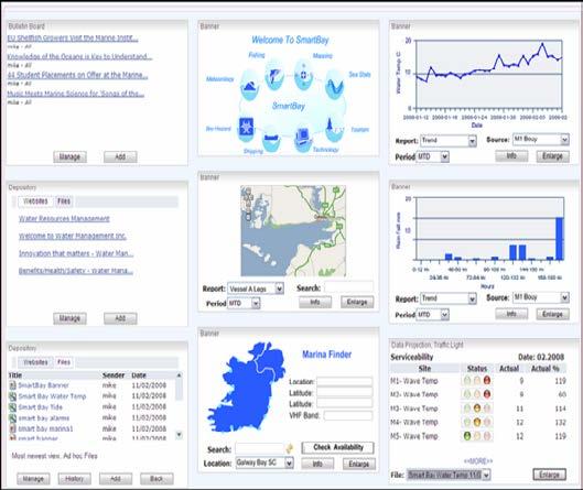
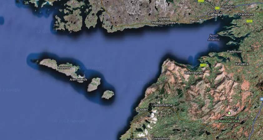
2 Galway Bay Smart Bay - Ireland

3 MARINE SCENARIOS

4 Background to MAST Marine Asset Management Decision Support Tool (MAST) is a web portal developed from the analysis of a number of uses cases developed by the marine work package of ENVIROFI The use case addresses a problem of how to access coastal marine waters in a safe way for the management of marine assets. Adaptable, scalable platform technology which can be translated to other marine stakeholders and support research and enterprise development. MAST delivers on the requirements for Ocean Energy Asset Management. (UC-ENV3.B-WAV-03-V03)
 Operational issue: Wave")

5 Scenario A: Wave Energy Asset Management Location: SmartBay, Galway Ireland (Location of ENVIROFI s 20 mw Virtual Wave Energy Farm) Operational issue: Wave farm manager needs to schedule preventative maintenance on wave energy array Challenge: Identify weather window for operational maintenance within maximum limits of constraints
6 The Weather Window This is the window of time when it is safe to put to sea. To identify a weather window requires: Intelligent integration of the real-time data coupled with model predictions. This is an essential tool in identifying weather windows of opportunity to schedule essential operational maintenance and repairs. Monitoring of the sea sate and marine traffic is also important. To make a decision the user needs data! This is a question that is applicable many different types of marine users.

7 Third Party Data Feed Automatic Ship Tracking (AIS) Aggregated by various 3 rd parties Served back via internet web services
8

9 Operational MI modelling Hydrodynamic model of northeast Atlantic km horizontal resolution 40 vertical levels 36,000,000 grid cells T, S, Ssh, velocity Daily 3-day forecast Weekly 7-day hindcast Data published to Thredds/FTP and web Hindcast data archived (LTO4) 560-core High Performance Computer


10 Weather Stations of Ireland Weather Buoy Marine Institute Weather Station

11 Marine Institute
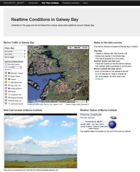


12 Real Time Conditions Part 1 Ship Tracking Data Web Cam Personal Weather Station


13 Real Time Conditions Part 2 Feeds from various Sensors in Galway Bay


14 The Ocean Weather Widget The Atlantic Ocean Buoy is a Platform for a number of sensors. You can select a sensor via the radio buttons.


")

15 Predicted Conditions Output from operational models (run once a day) Prediction of astronomical tide.


16 Wave Forecast Widget Clicking Next Advances Forecast By 3 hours

17 Galway Bay Dashboard
18 Acknowledgements Marine Institute JACINTA MC CREANOR EOIN O GRADY RAMONA CARR KEITH MANSON DAMIAN SMYTH Intune Networks Ltd. FERGAL WARD SmartBay Ireland Ltd. PAUL GAUGHAN Julia Falvey (MAST connection test, USA) Mike Kobernus (MAST connection test and IT support, NILU, Norway)


 under")
19 Thank you for your attention The research leading to these results has received funding from the European Community's Seventh Framework Programme (FP7/ ) under Grant Agreement Number
20 Galway Bay Dashboard ERRDAP is the core environmental enabler of WP3, to demonstrate the flexibility of the technology a dashboard demo was developed (next slide). The key features of the dashboard: MOST OF THE DATA LINKS ARE THE SAME AS THOSE USED IN MAST, ALL THAT HAS CHANGED IS FORMAT OF THE DATA THAT HAS BEEN REQUESTED. INSTEAD OF REQUESTING IMAGES OF GRAPHS THE DASHBOARD REQUESTS THE DATA AND COMPOSES THE GRAPHS IN THE BROWSER. THE DATA IS JSON FORMAT AND CROSS DOMAIN FUNCTIONALITY IS ACHIEVED BY USING JSONP. THE DASHBOARD HAS BEEN PUBLISHED ON THE WEB SERVERS OF THE MARINE INSTITUTE. ALL CODE IS CONTAINED WITH THE BROWSER.


21 Introduction Driving Use Case Global challenge of need for energy generation and security of supply Future development of arrays of offshore wind, wave and tidal marine energy systems planned Leverage internet-enabled decision support solutions for adaptive control of deployed marine infrastructures and related assets Decision support to schedule system preventative maintenance Reduce costs by maximizing power take off Improved security through integrated monitoring approach
: : User Manual: : - 10 December
 : : User Manual: : - 0 December 06 - : : User Manual: : Table of Contents. Map Control. How to move a map. How to zoom in and out a map 4. How to inquire Ocean Currents. How to inquire predicted current
Mermaid. The most sophisticated marine operations planning software available.
 Mermaid The most sophisticated marine operations planning software available. Mojo Maritime / Marine economic risk management aid Mermaid : marine economic risk management aid The most sophisticated marine
Integrated Electricity Demand and Price Forecasting
 Integrated Electricity Demand and Price Forecasting Create and Evaluate Forecasting Models The many interrelated factors which influence demand for electricity cannot be directly modeled by closed-form
Marine weather forecasting and monitoring at the Port of Sydney and Botany Bay, NSW, Australia
 Marine weather forecasting and monitoring at the Port of Sydney and Botany Bay, NSW, Australia Sebastien O. C. Boulay 1 and Lucy Batt 2 1 MetOcean Solutions Ltd, Raglan, New Zealand; s.boulay@metocean.co.nz
Mersea Oil Spill Drift Forecast Demonstrations in TOP2
 Mersea Oil Spill Drift Forecast Demonstrations in TOP2 Bruce Hackett (met.no), George Zodiatis (UCY), Pierre Daniel (MeteoFrance), Francois Parthiot (Cedre) Presented at 3rd Mersea Plenary Meeting, CNR,
IMS4 ARWIS. Airport Runway Weather Information System. Real-time data, forecasts and early warnings
 Airport Runway Weather Information System Real-time data, forecasts and early warnings Airport Runway Weather Information System FEATURES: Detection and prediction of runway conditions Alarms on hazardous
Introduction to Portal for ArcGIS
 Introduction to Portal for ArcGIS Derek Law Product Management March 10 th, 2015 Esri Developer Summit 2015 Agenda Web GIS pattern Product overview Installation and deployment Security and groups Configuration
NOAA Surface Weather Program
 NOAA Surface Weather Program Maintenance Decision Support System Stakeholder Meeting #9 Jim O Sullivan NOAA Surface Weather Program Manager NWS Office of Climate, Water, and Weather Services September
SAWS: Met-Ocean Data & Infrastructure in Support of Industry, Research & Public Good. South Africa-Norway Science Week, 2016
 SAWS: Met-Ocean Data & Infrastructure in Support of Industry, Research & Public Good South Africa-Norway Science Week, 2016 Marc de Vos, November 2016 South Africa: Context http://learn.mindset.co.za/sites/default/files/resourcelib/e
Extending the use of Flood Modeller Pro towards operational forecasting with Delft-FEWS
 Extending the use of Flood Modeller Pro towards operational forecasting with Delft-FEWS Simone van Schijndel, Department Head Operational Water Management and Early Warning Intentionally blank The world
Leveraging Web GIS: An Introduction to the ArcGIS portal
 Leveraging Web GIS: An Introduction to the ArcGIS portal Derek Law Product Management DLaw@esri.com Agenda Web GIS pattern Product overview Installation and deployment Configuration options Security options
Access to IOOS Data Relevant to OOI. Kathleen Bailey NOAA/NOS/IOOS January 6, 2016
 Access to IOOS Data Relevant to OOI Kathleen Bailey NOAA/NOS/IOOS January 6, 2016 The U.S. Integrated Ocean Observing System (IOOS) Federal Regional Satellites 600+: Buoys, Water Level stations, Coastal
MERSEA Marine Environment and Security for the European Area
 MERSEA Marine Environment and Security for the European Area Development of a European system for operational monitoring and forecasting of the ocean physics, biogeochemistry, and ecosystems, on global
ArcGIS. for Server. Understanding our World
 ArcGIS for Server Understanding our World ArcGIS for Server Create, Distribute, and Manage GIS Services You can use ArcGIS for Server to create services from your mapping and geographic information system
STAMP Spa)al Tools for Arc)c Mapping & Planning. Creating an interactive data tool to improve access and usability of Arctic data
al Tools for Arc)c Mapping & Planning. Creating an interactive data tool to improve access and usability of Arctic data") STAMP Spa)al Tools for Arc)c Mapping & Planning Creating an interactive data tool to improve access and usability of Arctic data Mission Provide easy access to physical, chemical, and biological data Network
STAMP Spa)al Tools for Arc)c Mapping & Planning Creating an interactive data tool to improve access and usability of Arctic data Mission Provide easy access to physical, chemical, and biological data Network
Can buoys predict hurricanes? Objectives Students will be able to: track drifter buoys determine the course of the gulf stream current
 Drifters Can buoys predict hurricanes? Objectives Students will be able to: track drifter buoys determine the course of the gulf stream current Materials computers with Internet access Student Worksheet
The Mediterranean Operational Oceanography Network (MOON): Products and Services
: Products and Services") The Mediterranean Operational Oceanography Network (MOON): Products and Services The MOON consortia And Nadia Pinardi Co-chair of MOON Istituto Nazionale di Geofisica e Vulcanologia Department of Environmental
The Mediterranean Operational Oceanography Network (MOON): Products and Services The MOON consortia And Nadia Pinardi Co-chair of MOON Istituto Nazionale di Geofisica e Vulcanologia Department of Environmental
Portal for ArcGIS: An Introduction. Catherine Hynes and Derek Law
 Portal for ArcGIS: An Introduction Catherine Hynes and Derek Law Agenda Web GIS pattern Product overview Installation and deployment Configuration options Security options and groups Portal for ArcGIS
Toward Environmental Predictions MFSTEP. Executive summary
 Research Project co-funded by the European Commission Research Directorate-General 5 th Framework Programme Energy, Environment and Sustainable Development Contract No. EVK3-CT-2002-00075 Project home
Complete Weather Intelligence for Public Safety from DTN
 Complete Weather Intelligence for Public Safety from DTN September 2017 White Paper www.dtn.com / 1.800.610.0777 From flooding to tornados to severe winter storms, the threats to public safety from weather-related
MetConsole AWOS. (Automated Weather Observation System) Make the most of your energy SM
 Make the most of your energy SM") MetConsole AWOS (Automated Weather Observation System) Meets your aviation weather needs with inherent flexibility, proven reliability Make the most of your energy SM Automated Weather Observation System
MetConsole AWOS (Automated Weather Observation System) Meets your aviation weather needs with inherent flexibility, proven reliability Make the most of your energy SM Automated Weather Observation System
New developments in data assimilation in MIKE 21/3 FM Assimilation of along-track altimetry data with correlated measurement errors
 New developments in data assimilation in MIKE 21/3 FM Assimilation of along-track altimetry data with correlated measurement errors EnKF Workshop 2016-06-20 Jesper Sandvig Mariegaard Henrik Andersson DHI
Advancing Real Time Observations and Coastal Modeling Forecasts-
 Advancing Real Time Observations and Coastal Modeling Forecasts- Moving Forward in a Changing Coastal Landscape Next Generation Navigation-Coastal Operations- Coastal and Nearshore Coastal Operational
U.S. Arctic Campaign Scenario
 Prepared by the NOAA Office of Ocean Exploration and Research for Nation Ocean Exploration Forum 2016: Beyond the Ships. Sea ice extent from National Snow Service Layer Credits: NOAA National Centers for
Use of Satellite Earth Observations, in situ data and numerical model capabilities for oil spill contingency. Page 1
 Use of Satellite Earth Observations, in situ data and numerical model capabilities for oil spill contingency Page 1 Oil spill service Page 2 Interest of Earth-Observation (EO) data for oil and gas companies
The IHPT Marine Spatial Data infrastructure and its contribution to the INSPIRE Directive
 The IHPT Marine Spatial Data infrastructure and its contribution to the INSPIRE Directive INSPIRE - GWF 2015 - Coastal & Marine session Lisbon Congress Center, Portugal - Thursday, 28 May 2015 Summary
Wind power and management of the electric system. EWEA Wind Power Forecasting 2015 Leuven, BELGIUM - 02/10/2015
 Wind power and management of the electric system EWEA Wind Power Forecasting 2015 Leuven, BELGIUM - 02/10/2015 HOW WIND ENERGY IS TAKEN INTO ACCOUNT WHEN MANAGING ELECTRICITY TRANSMISSION SYSTEM IN FRANCE?
MeteoGroup FleetGuard. The world s most comprehensive SaaS fleet management system
 MeteoGroup FleetGuard The world s most comprehensive SaaS fleet management system The fleet management challenge Whether you are fleet operator or charter owner, you bear great responsibility for revenue,
HY-2A Satellite User s Guide
 National Satellite Ocean Application Service 2013-5-16 Document Change Record Revision Date Changed Pages/Paragraphs Edit Description i Contents 1 Introduction to HY-2 Satellite... 1 2 HY-2 satellite data
The power of data brokers and requirements for data openness for machine to machine communication
 The power of data brokers and requirements for data openness for machine to machine communication The Example of Using Earth Science Data to Enhance Global Maritime Situational Awareness in the Blue Hub.
An Implementation of Mobile Sensing for Large-Scale Urban Monitoring
 An Implementation of Mobile Sensing for Large-Scale Urban Monitoring Teerayut Horanont 1, Ryosuke Shibasaki 1,2 1 Department of Civil Engineering, University of Tokyo, Meguro, Tokyo 153-8505, JAPAN Email:
Monitoring Extreme Weather Events. February 8, 2010
 Monitoring Extreme Weather Events February 8, 2010 Extensive network of over 800 stations across the Prairies Good coverage across entire agriculture production region Network of networks strategy includes
Keywords: Wind resources assessment, Wind maps, Baltic Sea, GIS
 Advanced Materials Research Online: 2013-10-31 ISSN: 1662-8985, Vol. 827, pp 153-156 doi:10.4028/www.scientific.net/amr.827.153 2014 Trans Tech Publications, Switzerland Mapping of Offshore Wind Climate
About Nnergix +2, More than 2,5 GW forecasted. Forecasting in 5 countries. 4 predictive technologies. More than power facilities
 About Nnergix +2,5 5 4 +20.000 More than 2,5 GW forecasted Forecasting in 5 countries 4 predictive technologies More than 20.000 power facilities Nnergix s Timeline 2012 First Solar Photovoltaic energy
Ocean Currents Student Activity Book
 Ocean Currents Student Activity Book I. Introduction Ocean currents influence the weather in coastal areas. They also influence sailing vessels. Though they visibly affect many people's lives, they are
Oceanology International, London, March 2012 Ocean Observation & Forecasting programme. An African Network of Offshore Real-Time Metocean Stations
 Oceanology International, London, March 2012 Ocean Observation & Forecasting programme An African Network of Offshore Real-Time Metocean Stations Valérie QUINIOU-RAMUS, Rémi ESTIVAL (TOTAL S.A., EP/DEV/TEC/GEO)
Decision Support, Field Mobility, and Analysis in National Security and Public Safety
 Technical Demonstration Decision Support, Field Mobility, and Analysis in National Security and Public Safety Chris Delaney, Esri Safe Communities are Smart Communities Using Data and Technology to Prevent,
Law Enforcement Solutions and Applications
 ArcGIS for Solutions and Applications Solutions and Applications ArcGIS for Platform ArcGIS for Collection of solutions and applications for law enforcement. Built on the ArcGIS platform. For any named
DEVELOPMENT OF A FORECAST EARLY WARNING SYSTEM ethekwini Municipality, Durban, RSA. Clint Chrystal, Natasha Ramdass, Mlondi Hlongwae
 DEVELOPMENT OF A FORECAST EARLY WARNING SYSTEM ethekwini Municipality, Durban, RSA Clint Chrystal, Natasha Ramdass, Mlondi Hlongwae LOCATION DETAILS AND BOUNDARIES ethekwini Municipal Area = 2297 km 2
USDOT Applications Utilizing RWIS
 USDOT Applications Utilizing RWIS Benjamin McKeever, P.E. Program Manager, Traveler Info & Road Weather Research & Innovative Technology Administration U.S. Department of Transportation September 4, 2008
Overview of NOS Coastal Ocean Operational Forecast Systems
 Overview of NOS Coastal Ocean Operational Forecast Systems Aijun Zhang NOAA/NOS Center for Operational Oceanographic Products and Services (CO-OPS) Frank Aikman III NOAA/NOS/OCS Coast Survey Development
The known requirements for Arctic climate services
 The known requirements for Arctic climate services based on findings described in STT White paper 8/2015 Johanna Ekman / EC PHORS STT Regional drivers The Arctic region is home to almost four million people
Geog 469 GIS Workshop. Managing Enterprise GIS Geodatabases
 Geog 469 GIS Workshop Managing Enterprise GIS Geodatabases Outline 1. Why is a geodatabase important for GIS? 2. What is the architecture of a geodatabase? 3. How can we compare and contrast three types
Ocean Observatories Initiative. Oscar Schofield Rutgers University. Ocean Leadership October 2010
 Ocean Observatories Initiative Oscar Schofield Rutgers University Ocean Leadership October 2010 What is OOI? THE VISION To launch an era of scientific discovery across and within the ocean basins, utilizing
Introduction to Portal for ArcGIS. Hao LEE November 12, 2015
 Introduction to Portal for ArcGIS Hao LEE November 12, 2015 Agenda Web GIS pattern Product overview Installation and deployment Security and groups Configuration options Portal for ArcGIS + ArcGIS for
Bathymetry. EMODnet Stakeholder Conference & Sea-basin Workshops February Bathymetry
 EMODnet Stakeholder Conference & Sea-basin Workshops 14-15 February 2017 Arctic checkpoint Belinda Kater On behalf of all Checkpoints http://www.emodnet.eu 1 ? is the study of the "beds" or "floors" of
NOOS EuroGOOS Annual meeting
 NOOS EuroGOOS Annual meeting 22.-23.11.2012 Hamburg Henning Wehde NOOS Chair NOOS objectives Co-ordinate, improve and harmonize the development of operational marine data and information services Provide
The GMES/MyOcean Marine Service and its applications
 The GMES/MyOcean Marine Service and its applications P.Y. Le Traon (Ifremer) P. Bahurel (Mercator Ocean) First BreTel Workshop May 31st, 2012 - St Malo Outline The GMES Marine Service and MyOcean What
Unique Vaisala Global Lightning Dataset GLD360 TM
 Unique Vaisala Global Lightning Dataset GLD360 TM / THE ONLY LIGHTNING DETECTION NETWORK CAPABLE OF DELIVERING HIGH-QUALITY DATA ANYWHERE IN THE WORLD GLD360 provides high-quality lightning data anywhere
Spatial Analysis with Web GIS. Rachel Weeden
 Spatial Analysis with Web GIS Rachel Weeden Agenda Subhead goes here Introducing ArcGIS Online Spatial Analysis Workflows Scenarios Other Options Resources ArcGIS is a Platform Making mapping and analytics
v=7tat9croynk&feature=youtu.be
 https://www.youtube.com/watch? v=7tat9croynk&feature=youtu.be Malta Summer School 2018 Operational Oceanography for Blue Growth EMODnet in a nutshell: unlocking, and offering access to, European marine
A Broad View of Geospatial Technology & Systems
 A Broad View of Geospatial Technology & Systems Pete Large Vice President, Trimble On the shoulders of giants 1 Since their time, our ability to generate geospatial information has grown exponentially
The Vaisala AUTOSONDE AS41 OPERATIONAL EFFICIENCY AND RELIABILITY TO A TOTALLY NEW LEVEL.
 The Vaisala AUTOSONDE AS41 OPERATIONAL EFFICIENCY AND RELIABILITY TO A TOTALLY NEW LEVEL. Weather Data Benefit For Society The four most important things about weather prediction are quality, reliability,
Portal for ArcGIS: An Introduction
 Portal for ArcGIS: An Introduction Derek Law Esri Product Management Esri UC 2014 Technical Workshop Agenda Web GIS pattern Product overview Installation and deployment Security and groups Configuration
Remote Sensing and Sensor Networks:
 SDG&E Meteorology Remote Sensing and Sensor Networks: Providing meteorological intelligence to support system operations Mike Espinoza Project Manager Steven Vanderburg Senior Meteorologist Brian D Agostino
Implementation of the Political Declaration on energy cooperation between the North Seas Countries. Support Group 1 on Maritime Spatial Planning
 Implementation of the Political Declaration on energy cooperation between the North Seas Countries Support Group 1 on Maritime Spatial Planning Work Programme 1. Work area as outlined in Annex I to the
Introduction to EMODnet
 Introduction to EMODnet Antonio Novellino Torino, 14-15 Ottobre 2015 What is EMODnet? Initiated by the European Commission in response to the EU Future Maritime Policy and Blue Growth, launched in June
Comprehensive Winter Maintenance Management System BORRMA-web MDSS inside to increase Road Safety and Traffic Flow
 Thorsten Cypra 1 Comprehensive Winter Maintenance Management System BORRMA-web MDSS inside to increase Road Safety and Traffic Flow American Public Works Association (APWA) Monday, 04/14/2008 3:30 4:30
Provide dynamic understanding of physical environment for ecosystem science and offshore operations and planning.
 ENHANCING THE CANADIAN METAREAS OPERATIONAL COUPLED OCEAN-ICE- ATMOSPHERE ANALYSIS AND FORECASTING SYSTEM FOR FINE-SCALE APPLICATIONS IN THE BEAUFORT SEA by Fraser Davidson, Greg Smith, Youyu Lu, Jean-Francois
Dr Marc Lucas CLS Toulouse, France.
 Dr Marc Lucas CLS Toulouse, France. Oceanology International 15th March 2012 Slide 1 Ocean depiction In the past: Information mainly comes from in situ measurements (ADCP) Now: The role of satellite data
Importance of Technology as part of the NWS New Orleans/Baton Rouge Impact- Based Decision Support Pilot Project
 Importance of Technology as part of the NWS New Orleans/Baton Rouge Impact- Based Decision Support Pilot Project NWS New Orleans Meteorologist-In-Charge: Ken Graham Emergency Response Specialist Team:
Forecast.io Driver. Installation and Usage Guide. Revision: 1.0 Date: Tuesday, May 20, 2014 Authors: Alan Chow
 Forecast.io Driver Installation and Usage Guide Revision: 1.0 Date: Tuesday, May 20, 2014 Authors: Alan Chow Contents Overview... 2 Features... 3 Usage Scenarios... 4 Change Log... 4 Disclaimer... 4 Driver
Imagery and the Location-enabled Platform in State and Local Government
 Imagery and the Location-enabled Platform in State and Local Government Fred Limp, Director, CAST Jim Farley, Vice President, Leica Geosystems Oracle Spatial Users Group Denver, March 10, 2005 TM TM Discussion
A Walk through TRIDEC s intermediate Tsunami Early Warning System
 Collaborative, Complex and Critical Decision-Support in Evolving Crisis A Walk through TRIDEC s intermediate Tsunami Early Warning System M. Hammitzsch, S. Reißland, and M. Lendholt EGU General Assembly,
Meridian Environmental Technology, Inc.
 Meridian Environmental Technology, Inc. Providing Tomorrow s Technology Today Meridian is committed to the support of its clients through advancement of science and technology A National Leader in Road
Geo-Enabling Digital India. 15 th Esri India User Conference GIS and Smart Cities
 15 th Esri India User Conference 2014 GIS and Smart Cities 15 th Esri India User Conference 2014 GIS and Smart Cities Agendra Kumar President, Esri India Our World Is Facing Serious Challenges Our World
ELF products in the ArcGIS platform
 ELF products in the ArcGIS platform Presentation to: Author: Date: NMO Summit 2016, Dublin, Ireland Clemens Portele 18 May 2016 The Building Blocks 18 May, 2016 More ELF users through affiliated platforms
Getting Smarter. E-Navigation Report, Atlantic: Presentation to SFC Mariners Workshop January 27, 2016
 E-Navigation Report, Atlantic: Getting Smarter Presentation to SFC Mariners Workshop January 27, 2016 By: Capt. Andrew Rae, VP Atlantic Canadian Marine Pilots Association E-Navigation initiatives in Atlantic
FOURTH INTERNATIONAL PORT METEOROLOGICAL OFFICERS WORKSHOP AND SUPPORT TO GLOBAL OCEAN OBSERVATIONS USING SHIP LOGISTICS
 FOURTH INTERNATIONAL PORT METEOROLOGICAL OFFICERS WORKSHOP AND SUPPORT TO GLOBAL OCEAN OBSERVATIONS USING SHIP LOGISTICS PMO-IV 8-10 DEC 2010, ORLANDO, FLORIDA, USA 1 This presentation is generally for
EMODnet High Resolution Seabed Mapping - further developing and providing a high resolution digital bathymetry for European seas
 EMODnet High Resolution Seabed Mapping - further developing and providing a high resolution digital bathymetry for European seas EGU Fall 2017 meeting New Orleans USA, December 2017 Schaap Dick MARIS,
1 Executive summary. 2 Principles of SAT-OCEAN service
 S SCOPE OF WORK FOR ROUTING SERVICES 1 Executive summary SAT-OCEAN has developed an innovative routing service enabling for significant time and energy savings. This solution is going beyond traditional
MeteoGroup RoadMaster. The world s leading winter road weather solution
 MeteoGroup RoadMaster The world s leading winter road weather solution Discover why RoadMaster is the world s leading winter road weather solution. Managing winter road maintenance means that you carry
Introduction to ArcGIS Maps for Office. Greg Ponto Scott Ball
 Introduction to ArcGIS Maps for Office Greg Ponto Scott Ball Agenda What is Maps for Office? Platform overview What are Apps for the Office? ArcGIS Maps for Office features - Visualization - Geoenrichment
Unique Vaisala Global Lightning Dataset GLD360 TM
 Unique Vaisala Global Lightning Dataset GLD360 TM / THE ONLY LIGHTNING DETECTION NETWORK CAPABLE OF DELIVERING SUCH HIGH-QUALITY DATA ANYWHERE IN THE WORLD GLD360 provides high-quality lightning data anywhere
Operational Storm Surge Forecasting for the Greak Lakes:
 Operational Storm Surge Forecasting for the Greak Lakes: Real-Time Data & Decision Support Systems to Facilitate Early Warnings for Shoreline Communities By Patrick Delaney, DHI Acknowledgements: Gord
Ice surveys, meteorological and oceanographic data What is available and up-to-date?
 Ice surveys, meteorological and oceanographic data What is available and up-to-date? Leader of the Norwegian Ice Service +47 77 62 13 15 - nick.hughes@met.no Norwegian Meteorological Institute met.no 1
What s New. August 2013
 What s New. August 2013 Tom Schwartzman Esri tschwartzman@esri.com Esri UC2013. Technical Workshop. What is new in ArcGIS 10.2 for Server ArcGIS 10.2 for Desktop Major Themes Why should I use ArcGIS 10.2
FHWA Road Weather Management Program Update
 FHWA Road Weather Management Program Update 2015 Winter Maintenance Peer Exchange Bloomington, MN September 21-25, 2015 Gabe Guevara FHWA Office of Operations Road Weather Management Team 2015 Winter Maintenance
ArcGIS is Advancing. Both Contributing and Integrating many new Innovations. IoT. Smart Mapping. Smart Devices Advanced Analytics
 ArcGIS is Advancing IoT Smart Devices Advanced Analytics Smart Mapping Real-Time Faster Computing Web Services Crowdsourcing Sensor Networks Both Contributing and Integrating many new Innovations ArcGIS
Lesson 16: Technology Trends and Research
 http://www.esri.com/library/whitepapers/pdfs/integrated-geoenabled-soa.pdf GEOG DL582 : GIS Data Management Lesson 16: Technology Trends and Research Overview Learning Objective Questions: 1. Why is integration
Overview of the Tropical Cyclone Guidance Project
 Overview of the Tropical Cyclone Guidance Project Dr. Jonathan L. Vigh With thanks to Mahsa Mirzargar (Univ. of Miami) Shanghai Typhoon Institute 09 July 2018 NCAR is sponsored by the National Science
Polar. Thematic Exploitation Platform. Andrew Fleming, BAS/Polar View ESRIN, 14 th October 2015
 Polar Thematic Exploitation Platform Andrew Fleming, BAS/Polar View ESRIN, 14 th October 2015 Why a Polar TEP? Polar regions play an important role in regulating and driving the global climate & experiencing
PI SERVER 2012 Do. More. Faster. Now! Copyr i g h t 2012 O S Is o f t, L L C. 1
 PI SERVER 2012 Do. More. Faster. Now! Copyr i g h t 2012 O S Is o f t, L L C. 1 AUGUST 7, 2007 APRIL 14, 2010 APRIL 24, 2012 Copyr i g h t 2012 O S Is o f t, L L C. 2 PI Data Archive Security PI Asset
GISLab (UK) School of Computing and Mathematical Sciences Liverpool John Moores University, UK. Dr. Michael Francis. Keynote Presentation
 School of Computing and Mathematical Sciences Liverpool John Moores University, UK. Dr. Michael Francis. Keynote Presentation") GISLab (UK) School of Computing and Mathematical Sciences Liverpool John Moores University, UK Dr. Michael Francis Keynote Presentation Dr. Michael Francis North-West GIS Research Laboratory, LJMU, Liverpool,
GISLab (UK) School of Computing and Mathematical Sciences Liverpool John Moores University, UK Dr. Michael Francis Keynote Presentation Dr. Michael Francis North-West GIS Research Laboratory, LJMU, Liverpool,
The Information System in ECDIS
 The Information System in ECDIS Bjørn Åge Hjøllo Product Manager Weather/Routing/Piracy Jeppesen, Norway Nordic Institute of Navigation (NNF); Seminar on enavigation Bergen, May 2011 19 May 2011-1 - enavigation
GIS for Crime Analysis. Building Better Analysis Capabilities with the ArcGIS Platform
 GIS for Crime Analysis Building Better Analysis Capabilities with the ArcGIS Platform Crime Analysis The Current State One of the foundations of criminological theory is that three things are needed for
Flood and Sea Level Rise Mapping Methodologies: The Way Forward
 Flood and Sea Level Rise Mapping Methodologies: The Way Forward Malcolm L. Spaulding Professor Emeritus, Ocean Engineering University of Rhode Island spaulding@egr.uri.edu Interagency Coordination Meeting
An Industry Perspective. Bryn Fosburgh Vice President Trimble
 An Industry Perspective Bryn Fosburgh Vice President Trimble Who are we? Professionals & Consultants Geospatial Professionals working at or with: AEC Consultants Transportation Departments Construction
E x a m p l e s o f t o o l s f o r s e a s i t u a t i o n a l a w a r e n e s s u s i n g C M E M S d a t a. Copernicus EU
 E x a m p l e s o f t o o l s f o r s e a s i t u a t i o n a l a w a r e n e s s u s i n g C M E M S d a t a Copernicus EU Copernicus EU Copernicus EU www.copernicus.eu S e a S i t u a t i o n a l A w
Web GIS: Architectural Patterns and Practices. Shannon Kalisky Philip Heede
 Web GIS: Architectural Patterns and Practices Shannon Kalisky Philip Heede Web GIS Transformation of the ArcGIS Platform Desktop Apps Server GIS Web Maps Web Scenes Layers Web GIS Transformation of the
The Kentucky Mesonet: Entering a New Phase
 The Kentucky Mesonet: Entering a New Phase Stuart A. Foster State Climatologist Kentucky Climate Center Western Kentucky University KCJEA Winter Conference Lexington, Kentucky February 9, 2017 Kentucky
Information System as a Tool for Marine Spatial Planning The SmartSea Vision and a Prototype
 Information System as a Tool for Marine Spatial Planning The SmartSea Vision and a Prototype Ari Jolma Marine Research Centre Finnish Environment Institute May 10, 2017 ISESS 2017, Zadar, Croatia Contents
SECOORA Data Portal Exercises
 SECOORA Data Portal Exercises Exercise #1: April 2018- Carolina Storm using Historic Real-time Sensor Exercise #2: Exploration of Data Trends for Estuarine Fish Abundance and Sea Surface Temperature Exercise
Marine Transportation and Ocean Use
 Marine Transportation and Ocean Use Data Needs for Multi-Disciplinary Long-Term Planning 4 th Biennial TRB-CMTS Research and Development Conference Matt Campo Rutgers University 6/22/2016 Overview What
Coastal Response Research Center. Nancy Kinner University of New Hampshire (UNH) Michele Jacobi NOAA ORR. September 27, 2007
 Michele Jacobi NOAA ORR. September 27, 2007") Coastal Response Research Center Nancy Kinner University of New Hampshire (UNH) Michele Jacobi NOAA ORR September 27, 2007 1 Coastal Response Research Center (CRRC) CRRC is partnership between NOAA s Office
Coastal Response Research Center Nancy Kinner University of New Hampshire (UNH) Michele Jacobi NOAA ORR September 27, 2007 1 Coastal Response Research Center (CRRC) CRRC is partnership between NOAA s Office
National Polish services using regional products
 Oceanographic services for the European regions - session organized by EuroGOOS European Maritime Day, Gdańsk, 20th May 2011 Polish Baltic Frédéric Chopin Philharmonic, Chamber Green Hall National Polish
OFWIM 2017 Annual Conference What Does Web GIS Really Mean for Fish and Wildlife Agencies?
 Content Open Mapping OFWIM 2017 Annual Conference What Does Web GIS Really Mean for Fish and Wildlife Agencies? Imagery Spatial Analysis Mike Bialousz, Esri 3D Data Exploration Real-Time Apps Visualization
12/2/15. Providing observa.ons, data and informa.on products to meet agency and stakeholder needs
 12/2/15 Providing observa.ons, data and informa.on products to meet agency and stakeholder needs 1 Part of the Integrated Ocean Observing System (IOOS) Governed through a Memorandum of Agreement Fiscal
Earth Observation in coastal zone MetOcean design criteria
 ESA Oil & Gas Workshop 2010 Earth Observation in coastal zone MetOcean design criteria Cees de Valk BMT ARGOSS Wind, wave and current design criteria geophysical process uncertainty modelling assumptions