The Information System in ECDIS
|
|
|
- Allen Lane
- 5 years ago
- Views:
Transcription
; Seminar on enavigation Bergen, May 2011 19 May 2011-1")
1 The Information System in ECDIS Bjørn Åge Hjøllo Product Manager Weather/Routing/Piracy Jeppesen, Norway Nordic Institute of Navigation (NNF); Seminar on enavigation Bergen, May May
2 enavigation and ECDIS From my experience in electronic charts & MetOc services: 1) enavigation and Mandatory ECDIS slower uptake than expected? 2) Some practical examples of Information Systems from an on board perspective 19 May
3 enavigation WHAT IS e-navigation? e-navigation is an International Maritime Organization (IMO) led concept based on the harmonisation of marine navigation systems and supporting shore services driven by user needs. e-navigation is currently defined as: e-navigation is the harmonised collection, integration, exchange, presentation and analysis of maritime information onboard and ashore by electronic means to enhance berth to berth navigation and related services, for safety and security at sea and protection of the marine environment. Core elements are; high integrity electronic positioning, ENC and analysis capability to reduce human error,. 19 May
 : 1) Sufficient coverage to come 2) Pricing is not favorable 3) Updating and licensing must be improved (too much hassle today) Still no")
4 enavigation slower uptake than expected? Customer feedback on ENC service (compared to C-MAP Prof+) : 1) Sufficient coverage to come 2) Pricing is not favorable 3) Updating and licensing must be improved (too much hassle today) Still no hurry; ECDIS mandate will come Majority in 2014 and later. ECDIS (+ ENC) or ECS (+ non ENC)? - Most customer buy ECDIS approved HW, but do not invest in ENCs yet. - ECDIS with non-encs is still an ECS, i.e. they continue to navigate in paper charts. 19 May
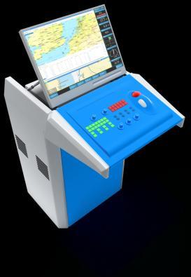
5 Electronic Chart Display and Information System Nautical Charts & Updating/licensing Communication Vessel Shore Route & Voyage planning Weather Service Piracy Integration Route Exchange with ECDIS 19 May


 19 May")
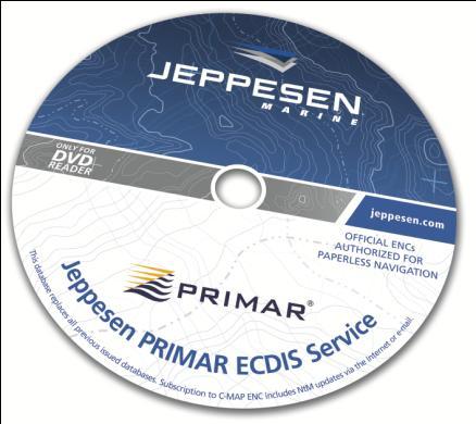
6 Charts and Updating Nautical charts: ENC; Official Charts for paperless navigation world wide, to be used in ECDIS Proff+ charts; aid for navigation, used in ECS Updating: By Internet or Backup; DVD every month Only provider of electronic updating of New Editions (due to hyper compact CM-93 format and SENC distribution) 19 May


7 Communication Vessel Shore HTTP 4 x Folder - using predefined send & receive folders File - send request, a received file is just to double-clicked! MAPI - using clients inbox & outbox POP/SMTP Scheduled download by ; data received every day at a given time Using proprietary CM-93 format; about 50% of GRIB files (GRIB is today industry standard) 19 May


8 Route & Voyage planning In coastal waters; use chart details to comply to navigational regulation In open sea; Less regulated, but Safety, Efficiency and Security will apply NB! A variety of professional Nautical Tools is available 19 May

9 Weather Forecast Jeppesen Weather Service: Weather and wave forecast from ECMWF (world leading) Current & SST (Mercator) Tropical Cyclone track Satellite wind observations Tidal data Climatology of wind and waves Online access to Historical Forecast Alarm tools, times series, weather windows, etc GUI to tailor presentation E.g. Compare routes against latest Weather Forecast: Green legs are below WX alarm Red legs are beyond WX alarm 19 May


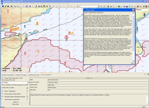
10 Piracy Jeppesen Piracy Service; Piracy Detection and Avoidance! Always updated with latest piracy incident world wide Faster updated then webservices Detect pattern of Mother-Ships Combine with Wave Height forecast to seek routes with wave > 1.75m Add info that reduces pirates operation ability: Cloudiness, Precipitation Nautical Twilight Moon Phases!! 19 May
 Quality of Data 2) Integration; Merge Chart and Weather/MetOcean data")
11 Integration Weather + Navigation integrated! Aim; Bring important nautical information on board, and help Navigator to utilize it Focus; 1) Quality of Data 2) Integration; Merge Chart and Weather/MetOcean data into a user friendly GUI 3) Tailored Tools for Safe and Efficient Navigation Don t be surprised by Weather! 19 May


12 Route Exchange Planning Station Detailed route planning to be made easy by utilizing updated Nautical information ECDIS Route check, Route Planning and Paperless Navigation Route exchange 19 May


13 Safety - Integration - Exchange Weather & Routing Charts - ENC Piracy / Internet Planning station Back of Bridge Route Exchange ECDIS; Front of Bridge 19 May


14 Practical use of an Information Systems 19 May


15 Route without Piracy info 19 May

16 With updated Piracy information Shortest route may be the best option; probably more Secure, and more Fuel Efficient US Navy and OCIMF - use of best management practices deters piracy 19 May


17 Identify patterns, and verify WX-forecast :20 UTC :45 UTC :04 UTC... within ~ 40 nm 460 nm off Somalia. Mother ship? Wave Height is about 1 meter, wind is verified by satellite observations: STAY OUT!! 19 May

18 Attacks last 6 weeks End Nov Possible Mother Ships: 19 May

19 Sorry Piracy will not disappear... May 18th , The German Institute for Economic Research (DIW): The presence of international war ships has failed to curtail pirate attacks. Pirates have merely shifted from the Gulf of Aden to the open seas in the Indian Ocean. (DN.no): The number of attacks has in fact more than doubled last years: In 2008, 111 ships were attacked In 2009, 217 ships were attacked In 2010, 242 vessels were attached, 61 were succesful. In January 2011 are 30 vessels and 680 mariners hijacked. 19 May


20 Jeppesen Piracy Service; Awarded the 2010 Safety at Sea International Security Award Questions please? 19 May
WEATHERNAV & PIRACY. As available in OceanView 4.3 & SDK 4.3 and later. Bjørn Åge Hjøllo
 WEATHERNAV & PIRACY As available in OceanView 4.3 & SDK 4.3 and later Bjørn Åge Hjøllo Product Manager Weather Services safenav@jeppesen.com December 2009 14 December 2009-1 - AGENDA Quality of input data
Page 1. A Grieg Group Company
 Page 1 ECDIS PAST, PRESENT & Future 2000-2010 Past Present 2010-2015 2015... Future Page 2 History Page 3 DEEPLY - Past What is going on there????? I am Checking now Sir Page 4 ECDIS History ECDIS has
Routeing. Voyage preparation, -planning and -implementation
 Routeing Voyage preparation, -planning and -implementation Routeing possibilities Weather routeing By own information By external party Climatologic Routeing By charts and books Weather Routeing Basis
1 Executive summary. 2 Principles of SAT-OCEAN service
 S SCOPE OF WORK FOR ROUTING SERVICES 1 Executive summary SAT-OCEAN has developed an innovative routing service enabling for significant time and energy savings. This solution is going beyond traditional
: : User Manual: : - 10 December
 : : User Manual: : - 0 December 06 - : : User Manual: : Table of Contents. Map Control. How to move a map. How to zoom in and out a map 4. How to inquire Ocean Currents. How to inquire predicted current
TECDIS and TELchart ECS Weather Overlay Guide
 1 of 24 TECDIS and TELchart ECS provides a very advanced weather overlay feature, using top quality commercial maritime weather forecast data available as a subscription service from Jeppesen Marine. The
Use of GlobWave data by the Royal Australian Navy
 Use of GlobWave data by the Royal Australian Navy Martin Rutherford Director Maritime Military Geospatial Information Hydrography and METOC Branch Royal Australian Navy 07 November 2012 Outline Anti Piracy
COUNTRY REPORT ON CARTOGRAPHIC ACTIVITIES IN SINGAPORE ( ) Submitted by Singapore **
 Submitted by Singapore **") UNITED NATIONS E/CONF.97/5/CRP. 9 ECONOMIC AND SOCIAL COUNCIL Seventeenth United Nations Regional Cartographic Conference for Asia and the Pacific Bangkok, 18-22 September 2006 Item 6 (b) of the provisional
UNITED NATIONS E/CONF.97/5/CRP. 9 ECONOMIC AND SOCIAL COUNCIL Seventeenth United Nations Regional Cartographic Conference for Asia and the Pacific Bangkok, 18-22 September 2006 Item 6 (b) of the provisional
Mermaid. The most sophisticated marine operations planning software available.
 Mermaid The most sophisticated marine operations planning software available. Mojo Maritime / Marine economic risk management aid Mermaid : marine economic risk management aid The most sophisticated marine
THAILAND NATIONAL REPORT
 NIOHC14 TH National Report THAILAND NATIONAL REPORT 14 th NORTH INDIAN OCEAN HYDROGRAPHIC COMMISSION (NIOHC) CONFERENCE Bangkok, Thailand 26 th 28 th February 2014 1 CONTENTS 1. Hydrographic Office / Service...
Maritime Standards. Rafael Ponce Tom De Puyt
 Maritime Standards Rafael Ponce Tom De Puyt Content The International Hydrographic Organization - Overview - Existing Support - Committees and Working Groups - Technology - Runtime - MCS Next Generation
Paul Bridge Meteorologist Vaisala/UKMO Work Groups/Committees: WMO/TRB/AMS
 Paul Bridge Meteorologist Vaisala/UKMO Work Groups/Committees: WMO/TRB/AMS Introduction (a) Identify and establish, if possible, inventories of transport networks in the ECE region which are vulnerable
Coast Survey Providing Improved Access to Maritime Navigation Products and Services
 Coast Survey Providing Improved Access to Maritime Navigation Products and Services Kurt A. Nelson, Branch Chief CGTP Leland Snyder, Branch Chief FADS Office of Coast Survey Agenda Current Coast Survey
ANNEX 23 RESOLUTION MSC.231(82) ADOPTION OF AMENDMENTS TO THE EXISTING MANDATORY SHIP REPORTING SYSTEM IN THE GULF OF FINLAND
 ADOPTION OF AMENDMENTS TO THE EXISTING MANDATORY SHIP REPORTING SYSTEM IN THE GULF OF FINLAND") RESOLUTION MSC.231(82) (adopted on 5 December 2006) ADOPTION OF AMENDMENTS TO THE EXISTING MANDATORY SHIP REPORTING SYSTEM IN THE GULF OF FINLAND THE MARITIME SAFETY COMMITTEE, RECALLING Article 28(b)
RESOLUTION MSC.231(82) (adopted on 5 December 2006) ADOPTION OF AMENDMENTS TO THE EXISTING MANDATORY SHIP REPORTING SYSTEM IN THE GULF OF FINLAND THE MARITIME SAFETY COMMITTEE, RECALLING Article 28(b)
VOYAGE (PASSAGE) PLANNING
 PLANNING") VOYAGE (PASSAGE) PLANNING Introduction O Passage planning or voyage planning is a procedure of developing a complete description of a vessel's voyage from start to finish. O Production of a passage plan
VOYAGE (PASSAGE) PLANNING Introduction O Passage planning or voyage planning is a procedure of developing a complete description of a vessel's voyage from start to finish. O Production of a passage plan
THAILAND NATIONAL REPORT
 NIOHC18 TH National Report THAILAND NATIONAL REPORT 18 th NORTH INDIAN OCEAN HYDROGRAPHIC COMMISSION (NIOHC) CONFERENCE Goa, India 9 th 12 th April 2018-1 - CONTENTS 1. Hydrographic Office / Service 3
Digital Mariner s Routeing Guide An Exploration of the Standardization and Online Delivery of Marine Information
 Digital Mariner s Routeing Guide An Exploration of the Standardization and Online Delivery of Marine Information Raphael M MALYANKAR, USA Jeppesen Topic: Poster; (D,E) INTRODUCTION Maritime data is produced
Quick Reference Manual. Ver. 1.3
 Quick Reference Manual Ver. 1.3 1 EXASITE Voyage EXSITE Voyage is a web-based communication tool designed to support the following users; Ship operators who utilize Optimum Ship Routing (OSR) service in
The Mid Latitude Low trends Check the clouds: Check the barometer: Check the wind: Check the temperature:
 The Mid Latitude Low Mid Latitude lows tend to develop along stationary fronts. In particular, they tend to develop along a boundary between a cold, polar air mass and a warm, tropical air mass. As they
e-navigation: From Paper to Digital
 e-navigation: From Paper to Digital General overview Neptune Vessel Information System Preserve the navigator avoid a play station mode on bridge Handling the weather by Seaware StormGeo Jan B. Stockfleth,
ENC and SDI: Convergence Issues. Tatiana DELGADO Fernández GEOCUBA, Hydrographic and Geodetic Service of Cuba
 ENC and SDI: Convergence Issues Tatiana DELGADO Fernández GEOCUBA, Hydrographic and Geodetic Service of Cuba tatiana@geocuba.co.cu Michel HUET International Hydrographic Bureau, Monaco mhuet@ihb.mc ABSTRACT
14 th NIOHC, Myanmar National Report MYANMAR NAVAL HYDROGRAPHIC CENTRE (MNHC) NATIONAL REPORT HYDROGRAPHIC DEPARTMENT, ROYAL THAI NAVY-HDRTN
 NATIONAL REPORT HYDROGRAPHIC DEPARTMENT, ROYAL THAI NAVY-HDRTN") 14 th NIOHC, Myanmar National Report MYANMAR NAVAL HYDROGRAPHIC CENTRE (MNHC) NATIONAL REPORT 14 th NORTH INDIAN OCEAN HYDROGRAPHIC COMMISSION CONFERENCE HYDROGRAPHIC DEPARTMENT, ROYAL THAI NAVY-HDRTN
14 th NIOHC, Myanmar National Report MYANMAR NAVAL HYDROGRAPHIC CENTRE (MNHC) NATIONAL REPORT 14 th NORTH INDIAN OCEAN HYDROGRAPHIC COMMISSION CONFERENCE HYDROGRAPHIC DEPARTMENT, ROYAL THAI NAVY-HDRTN
IHO STAKEHOLDERS FORUM. Hydrographic data and its role in MSDI. Thursday 27 September Jens Peter Hartmann KMS
 IHO STAKEHOLDERS FORUM Hydrographic data and its role in MSDI Thursday 27 September Jens Peter Hartmann KMS Agenda Traditional approach to hydrographic data Expectations within the marine / maritime field
Advancing Real Time Observations and Coastal Modeling Forecasts-
 Advancing Real Time Observations and Coastal Modeling Forecasts- Moving Forward in a Changing Coastal Landscape Next Generation Navigation-Coastal Operations- Coastal and Nearshore Coastal Operational
P r o d u c t p o r t f o l i o a n d d a t a a c c e s s
 P r o d u c t p o r t f o l i o a n d d a t a a c c e s s Copernicus Environment Service Copernicus EU Copernicus EU Copernicus EU www.copernicus.eu I N T R O D U C T I O N O F U S E C A S E User Uptake
Maritime Weather Information: Automatic Reporting, A New Paradigm
 Maritime Weather Information: Automatic Reporting, A New Paradigm Joe Sienkiewicz, NOAA/NWS Ocean Prediction Center Responsibilities under SOLAS Met Services Contracting governments Observations Limited
Higher National Unit Specification. General information for centres. Applied Marine Meteorology. Unit code: F0LP 35
 Higher National Unit Specification General information for centres Unit title: Applied Marine Meteorology Unit code: F0LP 35 Unit purpose: This Unit is about interpreting and evaluating meteorological,
The Vaisala AUTOSONDE AS41 OPERATIONAL EFFICIENCY AND RELIABILITY TO A TOTALLY NEW LEVEL.
 The Vaisala AUTOSONDE AS41 OPERATIONAL EFFICIENCY AND RELIABILITY TO A TOTALLY NEW LEVEL. Weather Data Benefit For Society The four most important things about weather prediction are quality, reliability,
MeteoGroup FleetGuard. The world s most comprehensive SaaS fleet management system
 MeteoGroup FleetGuard The world s most comprehensive SaaS fleet management system The fleet management challenge Whether you are fleet operator or charter owner, you bear great responsibility for revenue,
3.7 MYWXMAP: A NEW APPRAOCH TO WEB-BASED METEOROLOGICAL AND OCEANOGRAPHIC (METOC) CHART DISPLAY
 CHART DISPLAY") 3.7 MYWXMAP: A NEW APPRAOCH TO WEB-BASED METEOROLOGICAL AND OCEANOGRAPHIC (METOC) CHART DISPLAY Carl D. Thormeyer* and Earl V. Ravid Fleet Numerical Meteorology and Oceanography Center (FNMOC) Monterey,
3.7 MYWXMAP: A NEW APPRAOCH TO WEB-BASED METEOROLOGICAL AND OCEANOGRAPHIC (METOC) CHART DISPLAY Carl D. Thormeyer* and Earl V. Ravid Fleet Numerical Meteorology and Oceanography Center (FNMOC) Monterey,
PARTICIPATION IN THE WMO VOLUNTARY OBSERVING SHIPS (VOS) SCHEME
 SCHEME") INTERNATIONAL MARITIME ORGANIZATION 4 ALBERT EMBANKMENT LONDON SE1 7SR Telephone: 020 7735 7611 Fax: 020 7587 3210 IMO E Ref. T2-OSS/1.4 MSC.1/Circ.1293 10 December 2008 PARTICIPATION IN THE WMO VOLUNTARY
INTERNATIONAL MARITIME ORGANIZATION 4 ALBERT EMBANKMENT LONDON SE1 7SR Telephone: 020 7735 7611 Fax: 020 7587 3210 IMO E Ref. T2-OSS/1.4 MSC.1/Circ.1293 10 December 2008 PARTICIPATION IN THE WMO VOLUNTARY
Marine Information Objects: What, Why and How
 Marine Information Objects: What, Why and How Dr. Lee Alexander, Univ. of New Hampshire Michel Huet, IHB Marine Information Objects (MIOs) - Chart and navigation-related information that supplement the
WAFS_Word. 2. Menu. 2.1 Untitled Slide
 WAFS_Word 2. Menu 2.1 Untitled Slide Published by Articulate Storyline 1. Introduction 1.1 Introduction Notes: As you will probably be aware, the traditional significant weather forecasts, usually seen
an accessible interface to marine environmental data Russell Moffitt
 an accessible interface to marine environmental data Russell Moffitt The Atlas Project GOAL: To provide a single point of access to oceanographic and environmental data for use by marine resource researchers,
SUMMARY. Executive Summary: NAVAREA VIII provides the paper of MSI Self Assessment for CPRNW 10
 CPRNW Meeting 10 Agenda Item 3.2.1 CPRNW10/3/2/VIII MSI Self Assessment - NAVAREA VIII Submitted by INDIA SUMMARY Executive Summary: NAVAREA VIII provides the paper of MSI Self Assessment for CPRNW 10
NOAA Nautical Charts and Coastal and Marine Spatial Planning. Meredith Westington Chief Geographer NOAA/NOS/Office of Coast Survey
 NOAA Nautical Charts and Coastal and Marine Spatial Planning Meredith Westington Chief Geographer NOAA/NOS/Office of Coast Survey Ocean Policy Task Force What is CMSP? A comprehensive, adaptive, integrated,
THAILAND NATIONAL REPORT
 NIOHC19 TH National Report THAILAND NATIONAL REPORT 19 th MEETING OF THE NORTH INDIAN OCEAN HYDROGRAPHIC COMMISSION (NIOHC19) MUSCAT, OMAN 25 th 28 th March 2019-1 - CONTENTS 1. Hydrographic Office / Service
Complete Weather Intelligence for Public Safety from DTN
 Complete Weather Intelligence for Public Safety from DTN September 2017 White Paper www.dtn.com / 1.800.610.0777 From flooding to tornados to severe winter storms, the threats to public safety from weather-related
Contribution of Norwegian partners (Aanderaa Data Instruments and NIVA) to Safeport project ( ). Final report
 to Safeport project ( ). Final report") Contribution of Norwegian partners (Aanderaa Data Instruments and NIVA) to Safeport project (2010-2012). Final report NFR-196866 Entry and Berthing Ship and Port Advising System as an Element of Port ITS.
Contribution of Norwegian partners (Aanderaa Data Instruments and NIVA) to Safeport project (2010-2012). Final report NFR-196866 Entry and Berthing Ship and Port Advising System as an Element of Port ITS.
Marine Information Objects (MIOs)
") Marine Information Objects (MIOs) Part 1: What They Are and Why Important Dr. Lee Alexander, Univ. of New Hampshire Michel Huet, IHB Marine Information Objects (MIOs) - Chart and navigation-related information
Marine Information Objects (MIOs) Part 1: What They Are and Why Important Dr. Lee Alexander, Univ. of New Hampshire Michel Huet, IHB Marine Information Objects (MIOs) - Chart and navigation-related information
Maciej Szymański, Bernard Wiśniewski
 Scientific Journals of the Maritime University of Szczecin Zeszyty Naukowe Akademii Morskiej w Szczecinie 2016, 48 (120), 182 186 ISSN 1733-8670 (Printed) Received: 29.04.2016 ISSN 2392-0378 (Online) Accepted:
Ocean Currents Student Activity Book
 Ocean Currents Student Activity Book I. Introduction Ocean currents influence the weather in coastal areas. They also influence sailing vessels. Though they visibly affect many people's lives, they are
NGGPS Community Sea Ice Model Recommendation Workshop. Rebecca Heim / Gene Petrescu NOAA/NWS Alaska Region
 NGGPS Community Sea Ice Model Recommendation Workshop Rebecca Heim / Gene Petrescu NOAA/NWS Alaska Region NWS Alaska Region Ice Services Excerpts from NOAAs Arctic Action Plan NOAA s National Weather Service
HY-2A Satellite User s Guide
 National Satellite Ocean Application Service 2013-5-16 Document Change Record Revision Date Changed Pages/Paragraphs Edit Description i Contents 1 Introduction to HY-2 Satellite... 1 2 HY-2 satellite data
IMO ROUTEING OF SHIPS, SHIP REPORTING AND RELATED MATTERS. Amendments to the existing mandatory ship reporting system In the Gulf of Finland
 INTERNATIONAL MARITIME ORGANIZATION E IMO SUB-COMMITTEE ON SAFETY OF NAVIGATION 52nd session Agenda item 3 NAV 52/3/5 12 April 2006 Original: ENGLISH ROUTEING OF SHIPS, SHIP REPORTING AND RELATED MATTERS
Add NOAA nowcoast Layers to Maps
 WebEOC Maps Add-on Quick Reference Guide Add NOAA nowcoast Layers to Maps Overview With Maps Add-on, you can configure an unlimited number of map layers. These layers allow you to control the data you
Higher National Unit Specification. General information for centres. Unit title: Meteorology 2. Unit code: D78H 35
 Higher National Unit Specification General information for centres Unit code: D78H 35 Unit purpose: This Unit is about interpreting and evaluating meteorological and climatological data, with the objective
New SPOT Program. Customer Tutorial. Tim Barry Fire Weather Program Leader National Weather Service Tallahassee
 New SPOT Program Customer Tutorial Tim Barry Fire Weather Program Leader National Weather Service Tallahassee tim.barry@noaa.gov Live Demonstration http://www.weather.gov/spot/ Live Demonstration http://www.weather.gov/spot/
Mersea Oil Spill Drift Forecast Demonstrations in TOP2
 Mersea Oil Spill Drift Forecast Demonstrations in TOP2 Bruce Hackett (met.no), George Zodiatis (UCY), Pierre Daniel (MeteoFrance), Francois Parthiot (Cedre) Presented at 3rd Mersea Plenary Meeting, CNR,
The IHPT Marine Spatial Data infrastructure and its contribution to the INSPIRE Directive
 The IHPT Marine Spatial Data infrastructure and its contribution to the INSPIRE Directive INSPIRE - GWF 2015 - Coastal & Marine session Lisbon Congress Center, Portugal - Thursday, 28 May 2015 Summary
Guided Notes Weather. Part 2: Meteorology Air Masses Fronts Weather Maps Storms Storm Preparation
 Guided Notes Weather Part 2: Meteorology Air Masses Fronts Weather Maps Storms Storm Preparation The map below shows North America and its surrounding bodies of water. Country borders are shown. On the
Coral Reef Electronic Chart Initiative: Protecting Corals, Saving Ships
 Proceedings: US Hydrographic Conference 2005, 29-31 March 2005, San Diego, CA Coral Reef Electronic Chart Initiative: Protecting Corals, Saving Ships Dr. Lee Alexander Center for Coastal and Ocean Mapping
On an Advanced Shipboard Information and Decision-making System for Safe and Efficient Passage Planning
 International Journal on Marine Navigation and Safety of Sea Transportation Volume 2 Number 1 March 28 On an Advanced Shipboard Information and Decision-making System for Safe and Efficient Passage Planning
MaxSea Time Zero. Strength and Features: is the most intuitive navigation software ever! Product catalogue 2009
 Strength and Features: All in one : software + charts + data New speed and smooth chart engine with 3D display Charts, 3D data and satellite pictures are mixed A worldwide coverage with Raster and Vector.mm3d
NATIONAL REPORT OF ESTONIA
 BSHC 21 th Conference 27-29 Sept 2016 Klaipeda, Lithuania NATIONAL REPORT OF ESTONIA Executive summary This report summarizes the activities of the Estonian Maritime Administration in the field of hydrography
HELCOM-VASAB Maritime Spatial Planning Working Group Twelfth Meeting Gdansk, Poland, February 2016
 HELCOM-VASAB Maritime Spatial Planning Working Group Twelfth Meeting Gdansk, Poland, 24-25 February 2016 Document title HELCOM database for the coastal and marine Baltic Sea protected areas (HELCOM MPAs).
National / Naval Ice Center (NIC) Operations Brief This brief is UNCLASSIFIED
 Operations Brief This brief is UNCLASSIFIED") National / Naval Ice Center (NIC) Operations Brief This brief is UNCLASSIFIED Christopher Szorc, Senior Ice Analyst/Forecaster USCG USN NOAA Outline NIC s mission is to provide timely, accurate and relevant
National / Naval Ice Center (NIC) Operations Brief This brief is UNCLASSIFIED Christopher Szorc, Senior Ice Analyst/Forecaster USCG USN NOAA Outline NIC s mission is to provide timely, accurate and relevant
Proposal to Include a Grid Referencing System in S-100
 1 st IHO-HSSC Meeting The Regent Hotel, Singapore, 22-24 October 2009 Paper for consideration by HSSC Proposal to Include a Grid Referencing System in S-100 Submitted by: Executive Summary: Related Documents:
Navigating the Hurricane Highway Understanding Hurricanes With Google Earth
 Navigating the Hurricane Highway Understanding Hurricanes With Google Earth 2008 Amato Evan, Kelda Hutson, Steve Kluge, Lindsey Kropuenke, Margaret Mooney, and Joe Turk Images and data courtesy hurricanetracking.com,
STATUS QUO REPORT ON ENC ACTIVITIES
 NETWORK OF DANUBE WATERWAY ADMINISTRATIONS South-East European Transnational Cooperation Programme STATUS QUO REPORT ON ENC ACTIVITIES UA - SHS Document ID: Activity: 5.2 Author / Project Partner: Date:
StormGeo is the global provider of advanced analytics and meteorological services delivering decision support for weather sensitive operations.
 StormGeo is the global provider of advanced analytics and meteorological services delivering decision support for weather sensitive operations. agenda Part 1 Part 2 Part 3 Part 4 Who are we? What do we
IHO Input to the Report of the UN Secretary General on Oceans and Law of the Sea Executive Summary General
 IHO Input to the Report of the UN Secretary General on Oceans and Law of the Sea The following notes provide information on activities of the International Hydrographic Organization that are relevant to
MaxSea TimeZero. is the most intuitive navigation software ever! Strength and Features: Product Catalogue
 Strength and Features: All in one : software + charts + data New fast and smooth chart engine with 3D display Intuitive and easy to user interface Charts, 3D data and satellite pictures are mixed A worldwide
Tonga Country Report
 Tonga Country Report Tonga Meteorological Services Ph. (676)35355 email: metstaff@met.gov.to Joint Meeting of RA II WIGOS Project and RA V TT-SU Jakarta, Indonesia / 11 October 2018 BMKG Headquarter Outline
Introduction to Weather Analytics & User Guide to ProWxAlerts. August 2017 Prepared for:
 Introduction to Weather Analytics & User Guide to ProWxAlerts August 2017 Prepared for: Weather Analytics is a leading data and analytics company based in Washington, DC and Dover, New Hampshire that offers
Quantum Series Product Catalog
 Measuring and Managing Healthy Living Quantum Series Product Catalog RJL Sciences is an FDA registered company RJL Sciences, Inc. 33939 Harper Avenue Clinton Township, MI 48035 USA Voice: 1-800-528-4513
The Nautical Almanac For The Year 2015 READ ONLINE
 The Nautical Almanac For The Year 2015 READ ONLINE 2015 Nautical Almanac: 2015 Commercial Edition: Paradise A position solution for every second of every minute of every hour of every day of the year for
The known requirements for Arctic climate services
 The known requirements for Arctic climate services based on findings described in STT White paper 8/2015 Johanna Ekman / EC PHORS STT Regional drivers The Arctic region is home to almost four million people
Connecting weather to boaters. Neal Moodie National Manager, Marine Weather Services May 2015
 Connecting weather to boaters Neal Moodie National Manager, Marine Weather Services May 2015 Supporting services with education Talk outline Weather education challenges and options How do boaties use/think
Weather and ice information as a tool for arctic marine and offshore services
 Weather and ice information as a tool for arctic marine and offshore services World Meteorological Organization Executive Council Panel of Experts on Polar Observations, Research and Services President
Maritime Safety Services. Supporting Safe and Efficient Transfer Operations
 Maritime Safety Services Supporting Safe and Efficient Transfer Operations Charles Tait 06 Ship to Ship (STS) Transfer is a critical and important, daily activity in the support of, and delivery of, Offshore
Fleet Asset Management
 Fleet Asset Management Maximum Profit by Minimum Planning April, 2017 1 PERFORMERS Performance is all that matters and that is what Fleet Asset Management is all about Brad Pitt Einstein Old Russian lady
JMA Contribution to SWFDDP in RAV. (Submitted by Yuki Honda and Masayuki Kyouda, Japan Meteorological Agency) Summary and purpose of document
 Summary and purpose of document") WORLD METEOROLOGICAL ORGANIZATION COMMISSION FOR BASIC SYSTEMS OPAG on DPFS DPFS/RAV-SWFDDP-RSMT Doc. 7.1(1) (28.X.2010) SEVERE WEATHER FORECASTING AND DISASTER RISK REDUCTION DEMONSTRATION PROJECT (SWFDDP)
WORLD METEOROLOGICAL ORGANIZATION COMMISSION FOR BASIC SYSTEMS OPAG on DPFS DPFS/RAV-SWFDDP-RSMT Doc. 7.1(1) (28.X.2010) SEVERE WEATHER FORECASTING AND DISASTER RISK REDUCTION DEMONSTRATION PROJECT (SWFDDP)
Reading and Interpreting Weather Data
 Reading and Interpreting Weather Data WxLive! Session 2 Copyright 2012 Weather4Sailors The material contained in this document is for the exclusive use of WxLive webinar participants and may not be shared
OFFSHORE. Advanced Weather Technology
 Contents 3 Advanced Weather Technology 5 Working Safely, While Limiting Downtime 6 Understanding the Weather Forecast Begins at the Tender Stage 7 Reducing Time and Costs on Projects is a Priority Across
NATIONAL REPORT OF THE HYDROGRAPHIC DEPARTMENT, ROYAL THAI NAVY
 NATIONAL REPORT OF THE HYDROGRAPHIC DEPARTMENT, ROYAL THAI NAVY to 11 th NORTH INDIAN OCEAN HYDROGRAPHIC COMMISSION MEETING NEW DELHI, INDIA 1-2 MARCH 2011 1. Hydrographic Office / Service Established
Meeting July 2018 Agenda Item 7.1. Tsunami Service Provider Messages for the Maritime Community. Submitted by IOC Secretariat SUMMARY
 WWNWS WWNWS10/7/1 Meeting 10 19 July 2018 Agenda Item 7.1 Tsunami Service Provider Messages for the Maritime Community Submitted by IOC Secretariat SUMMARY Executive Summary: This document provides details
Overview of the Tropical Cyclone Guidance Project
 Overview of the Tropical Cyclone Guidance Project Dr. Jonathan L. Vigh With thanks to Mahsa Mirzargar (Univ. of Miami) Shanghai Typhoon Institute 09 July 2018 NCAR is sponsored by the National Science
Frequently Asked Questions
 Frequently Asked Questions Can I still get paid via direct deposit? Can I use e- wallet to pay for USANA auto ship orders? Can I use e- wallet to pay for USANA products? Can I use e- wallet to pay for
Sea ice charts and SAR for sea ice classification. Patrick Eriksson Juha Karvonen Jouni Vainio
 Sea ice charts and SAR for sea ice classification Patrick Eriksson Juha Karvonen Jouni Vainio ECMWF Ocean Workshop, 22-25 January 2018 Ice service from past to present Finland has long experience in ice
E x a m p l e s o f t o o l s f o r s e a s i t u a t i o n a l a w a r e n e s s u s i n g C M E M S d a t a. Copernicus EU
 E x a m p l e s o f t o o l s f o r s e a s i t u a t i o n a l a w a r e n e s s u s i n g C M E M S d a t a Copernicus EU Copernicus EU Copernicus EU www.copernicus.eu S e a S i t u a t i o n a l A w
Weather Unit Part 2: Meteorology
 Name: Earth Science Date: Period: Weather Unit Part 2: Meteorology 1 The map below shows North America and its surrounding bodies of water. Country borders are shown. On the map, label the following locations:
Mauritius Meteorological Services
 Mauritius Meteorological Services Capabilities for the provision of climate services at national level Prem Goolaup Deputy Director St Paul Road, Vacoas. Mauritius Tel. +(230)57 86 08 38 Email: prem.goolaup@gmail.com
CONSIDERATION OF DESCRIPTIONS OF MARITIME SERVICES FROM DOMAIN COORDINATING BODIES
 INTERNATIONAL HYDROGRAPHIC ORGANIZATION E IMO/IHO HARMONIZATION GROUP ON DATA MODELLING Agenda item 5 30 October 2018 ENGLISH ONLY CONSIDERATION OF DESCRIPTIONS OF MARITIME SERVICES FROM DOMAIN COORDINATING
Output Module (last updated 8/27/2015)
") Output Module (last updated 8/27/2015) Goals: Provide a common output format and content from all modeling groups for Tier 2 files. Provide a data file that is compatible with the GFDL Vortex Tracker program
Output Module (last updated 8/27/2015) Goals: Provide a common output format and content from all modeling groups for Tier 2 files. Provide a data file that is compatible with the GFDL Vortex Tracker program
LOG_aLevel. Tsunami Warning System
 LOG_aLevel Tsunami Warning System General Acoustics e.k. Am Kiel-Kanal 1 24106 Kiel Germany Phone: +49 431 5 80 81 80 www.generalacoustics.com Info@generalacoustics.com LOG_aLevel Tsunami Warning System
MailASail Automatic Weather Responder
 MailASail Automatic Weather Responder As at November 2015. To get an up-to-date list, send a blank email to weather@mailasail.com with subject help-graphic. To use, click on a chart code below and send
Application and verification of ECMWF products 2016
 Application and verification of ECMWF products 2016 Icelandic Meteorological Office (www.vedur.is) Bolli Pálmason and Guðrún Nína Petersen 1. Summary of major highlights Medium range weather forecasts
Finnish Open Data Portal for Meteorological Data
 18.11.2013 1 Finnish Open Data Portal for Meteorological Data 14th Workshop on meteorological operational systems Roope Tervo Finnish Meteorological Institute Example of Data Sets -- Observations Data
COMNAP REPORT TO HCA OCT 09
 HCA9-06.2A COMNAP REPORT TO HCA-9 12-14 OCT 09 About COMNAP Pupose : To develop and promote best practice in managing the support of scientific research in Antarctica How Serving as a forum to develop
PUBLIC SAFETY POWER SHUTOFF POLICIES AND PROCEDURES
 PACIFIC GAS AND ELECTRIC COMPANY PUBLIC SAFETY POWER SHUTOFF POLICIES AND PROCEDURES SEPTEMBER 2018 1 PACIFIC GAS AND ELECTRIC COMPANY PUBLIC SAFETY POWER SHUTOFF POLICIES AND PROCEDURES SEPTEMBER 2018
E x a m p l e s o f t o o l s f o r s e a s i t u a t i o n a l a w a r e n e s s u s i n g C M E M S d a t a. Copernicus EU
 E x a m p l e s o f t o o l s f o r s e a s i t u a t i o n a l a w a r e n e s s u s i n g C M E M S d a t a Copernicus EU Copernicus EU Copernicus EU www.copernicus.eu S e a S i t u a t i o n a l A w
PAKISTAN NATIONAL REPORT
 PAKISTAN NATIONAL REPORT 16 th MEETING NORTH INDIAN OCEAN HYDROGRAPHIC COMMISSION (NIOHC) CHITTAGONG, BANGLADESH 14-16 MARCH 2016 BY PAKISTAN NAVY HYDROGRAPHIC DEPARTMENT HYDROGRAPHIC DEPARTMENT OF PAKISTAN
Reducing Risk When Coastal or Blue Water Cruising. Lee S Chesneau Lee Chesneau s Marine Weather
 Reducing Risk When Coastal or Blue Water Cruising Lee S Chesneau Lee Chesneau s Marine Weather www.weatherbylee.com lee@chesneaumarineweather.com Expect the Unexpected When anyone asks me how I can best
MECANISMS FOR PRODUCTION AND DISSEMINATION OF WEATHER WARNING IN COMOROS. By MOHAMED Hamid NATIONAL METEOROLOGICAL SERVICE IN COMOROS
 MECANISMS FOR PRODUCTION AND DISSEMINATION OF WEATHER WARNING IN COMOROS By MOHAMED Hamid NATIONAL METEOROLOGICAL SERVICE IN COMOROS PRETORIA, SOUTH AFRICA, 18 22 Novembre 2013 The Comoros Islands are
STAMP Spa)al Tools for Arc)c Mapping & Planning. Creating an interactive data tool to improve access and usability of Arctic data
al Tools for Arc)c Mapping & Planning. Creating an interactive data tool to improve access and usability of Arctic data") STAMP Spa)al Tools for Arc)c Mapping & Planning Creating an interactive data tool to improve access and usability of Arctic data Mission Provide easy access to physical, chemical, and biological data Network
STAMP Spa)al Tools for Arc)c Mapping & Planning Creating an interactive data tool to improve access and usability of Arctic data Mission Provide easy access to physical, chemical, and biological data Network
Forecast solutions for the energy sector
 Forecast solutions for the energy sector A/S Lyngsø Allé 3 DK-2970 Hørsholm Henrik Aalborg Nielsen, A/S 1 Consumption and production forecasts Heat load forecasts for district heating systems usually for
The benefits and developments in ensemble wind forecasting
 The benefits and developments in ensemble wind forecasting Erik Andersson Slide 1 ECMWF European Centre for Medium-Range Weather Forecasts Slide 1 ECMWF s global forecasting system High resolution forecast
Coastal Emergency Risks Assessment - CERA Real-Time Storm Surge and Wave Visualization Tool
 Coastal Emergency Risks Assessment - CERA Real-Time Storm Surge and Wave Visualization Tool Introduction This document provides guidance for using the Coastal Emergency Risks Assessment (CERA) visualization
Hurricane Season 2010 & NOAA s Deepwater Response
 Hurricane Season 2010 & NOAA s Deepwater Response What s Happened? What Will 2010 Bring? Possible Shoreline Effects Darin Figurskey Meteorologist-in-Charge NOAA s NWS Raleigh, NC NOAA s National Weather