Geo-Enabling Digital India. 15 th Esri India User Conference GIS and Smart Cities
|
|
|
- Amanda Maxwell
- 5 years ago
- Views:
Transcription
1 15 th Esri India User Conference 2014 GIS and Smart Cities
2 15 th Esri India User Conference 2014 GIS and Smart Cities Agendra Kumar President, Esri India


3 Our World Is Facing Serious Challenges


4 Our World Is Facing Serious Challenges


5 Our World Is Facing Serious Challenges


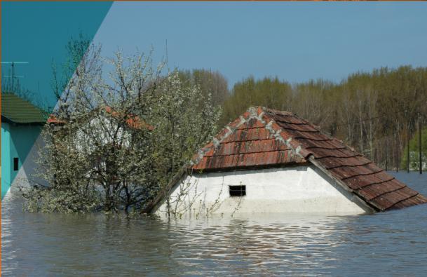
6 Smarter Cities are needed Urbanization Emerging Educated Neo-middle Class Better Living-conditions Expected Better Facilities Expected Urban Design Better Socio-economic Environment Sustainability


7 What do Citizens ask for Air Quality Analysis Housing Transportation Education Healthcare Safety & Security Environment Cleanliness Public Services Economy

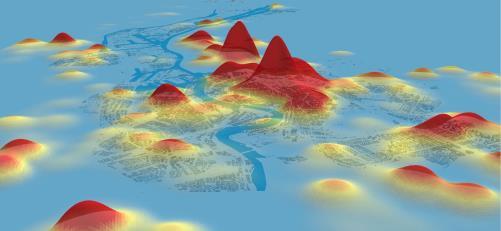
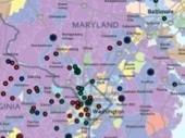
8 Urban Observatory Population Density

9 Urban Observatory Traffic Analysis


10 Spatial Analysis Space-Time Pattern Analysis Desktop 3D Analysis Supporting Demands for Better Understanding Interpolation Online Terrain Density Flow Visualization Route Optimization Drive-Time Areas Improved Modeling Buffer Find Nearest Multidimensional Data Overlay Hot Spots GeoEnrichment Aggregation Big Data Infographics Advancing the Science of Geography


11 Real-Time Supporting Geographic Monitoring and Alerting Arctic Shipping and Sea Ice Many Sensors Spatial Analysis Stream Service Big Data OSIsoft Integration PG&E Exact Earth OSIsoft Dashboard Big Data


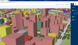
12 3D Enabling Visualization and Analysis on Desktops, Browsers, and Devices Web Scenes Lidar Analysis Rule-Based Symbology Editing and Designing CityEngine


13 GIS is used at every step Source: URA, Singapore Source: URA, Singapore Urban Climatic Mapping Studies for Singapore Singapore A Living Laboratory
14 To know more, visit us at:


")
15 ... Discipline-Independent Tools and Methods 2014 Geodesign Integrating the Design Process into GIS Geographic Planning Urban Design GeoPlanner CityEngine Feedback Data Analysis Design (Sketch) Evaluate Decision


16 Imagery Managing, Analyzing, and Serving Intelligent Imagery Landsat Services Impervious Surface Scientific Formats (HDF, GRIB, NetCDF) Dynamic Products Multidimensional Data Segmentation and Classification Tools Visualization and Analytics Full Motion Video On-the-Fly Processing Advanced Visualization Process Segmentation Output Supporting Single Scenes and Massive Collections

17 2014 Content A Ready-to-Use Living Atlas 15 th Esri India User Conference 2014

18 GeoEnrichment An Online Service for Appending Map Data to Your Data Business Data Landscape Data Demographics Your Data Data for over 120 Countries Available across the Platform


19 Apps


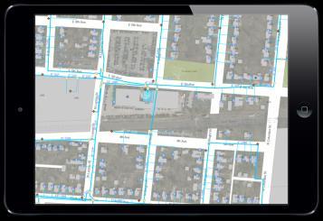


20 GIS Apps Included as Part of Online, Server, and Desktop Dashboard Story Maps Explorer Web Templates Briefing Book Support Multiple Devices Web AppBuilder Collector Open Data Online - Offline Support Immediately Deployable and Easily Configured


21 Open Data Easy Dissemination of Geospatial and Tabular Data Providing Multiformat Delivery

22 Interoperability Ensuring Data and System Interoperability Standards Industry Formats and Models WCS WMS GML KML GeoPackage WFS CSW WPS WMTS OPENDAP SOAP NetCDF SLD REST LAS IFC WaterML DXF OneGeology DWG AIXM Imagery DBMS CityGML OLEDB COLLADA DGN Hadoop FileGDB Shapefiles INSPIRE

23 GIS as a Platform Enabling Smart Cities Desktop Web Device Simple Integrated Open Portal Server Online Content and Services Available in the Cloud and On-Premises


24 Web GIS Integrates All Data Types With Web Maps and Web Services Enterprise Data Social Media Services Imagery Sensor Networks Maps Big Data Providing a New Medium for GIS
25 To know more, visit us at:
A Vision for ArcGIS Applying Geography Everywhere
 A Vision for ArcGIS Applying Geography Everywhere WELCOME PURPOSE A Network of GIS Professionals Are Awakening the World to the Power of Web GIS You Your WORK Making a Difference Your Work Open Maps and
Leveraging the Technology Revolution
 Leveraging the Technology Revolution Science, technology, and innovation to measure and monitor progress Moxie Zhang 张剑宇 We are living in a world that is constantly under development Our World Is full
ArcGIS is Advancing. Both Contributing and Integrating many new Innovations. IoT. Smart Mapping. Smart Devices Advanced Analytics
 ArcGIS is Advancing IoT Smart Devices Advanced Analytics Smart Mapping Real-Time Faster Computing Web Services Crowdsourcing Sensor Networks Both Contributing and Integrating many new Innovations ArcGIS
June 19 Huntsville, Alabama 1
 June 19 Huntsville, Alabama 1 Real-Time Geospatial Data: The Fusion of PI and ArcGIS Enabling Smarter Facilities Management OSIsoft and Esri Mapping and Location Analytics Platform Supporting Your Use
Managing and Analyzing Land Information
 ArcGIS Managing and Analyzing Land Information Tax Map Land Registration Predicting Vacancy Interagency Collaboration Cadastral Public Land Use Portal Russia Pennsylvania City of Philadelphia The Netherlands
Connecting Communities. Jeff Peters - Esri
 Connecting Communities Jeff Peters - Esri Public Safety and Security Infrastructure Protection Officer Involved Shootings and Violent Crimes DHS Police Foundation Operation Centers Mail Theft Live Incident
Smart Land Administration. Brent A. Jones, PE, PLS
 Smart Land Administration Brent A. Jones, PE, PLS bjones@esri.com What is Smart? Required Important Modern Open Secure Authoritative Sustainable Cost Effective Reliable Scalable Contributory Usable Timely
ArcGIS for INSPIRE. Marten Hogeweg Satish Sankaran
 ArcGIS for INSPIRE Marten Hogeweg Satish Sankaran Outline What is ArcGIS ArcGIS for INSPIRE Web GIS Case Studies Roadmap Q&A What is INSPIRE? INSPIRE is the legal framework for a European Spatial Data
Spatial Analysis with Web GIS. Rachel Weeden
 Spatial Analysis with Web GIS Rachel Weeden Agenda Subhead goes here Introducing ArcGIS Online Spatial Analysis Workflows Scenarios Other Options Resources ArcGIS is a Platform Making mapping and analytics
OFWIM 2017 Annual Conference What Does Web GIS Really Mean for Fish and Wildlife Agencies?
 Content Open Mapping OFWIM 2017 Annual Conference What Does Web GIS Really Mean for Fish and Wildlife Agencies? Imagery Spatial Analysis Mike Bialousz, Esri 3D Data Exploration Real-Time Apps Visualization
Introduction to ArcGIS Maps for Office. Greg Ponto Scott Ball
 Introduction to ArcGIS Maps for Office Greg Ponto Scott Ball Agenda What is Maps for Office? Platform overview What are Apps for the Office? ArcGIS Maps for Office features - Visualization - Geoenrichment
ArcGIS. for Server. Understanding our World
 ArcGIS for Server Understanding our World ArcGIS for Server Create, Distribute, and Manage GIS Services You can use ArcGIS for Server to create services from your mapping and geographic information system
Demystifying ArcGIS Online. Karen Lizcano Esri
 Demystifying ArcGIS Online Karen Lizcano Esri An Integrated Web GIS Platform Desktop Web Device Powered by Services Managed via Portal Access from any Device Portal Server Online Content and Services ArcGIS
You are Building Your Organization s Geographic Knowledge
 You are Building Your Organization s Geographic Knowledge And Increasingly Making it Available Sharing Data Publishing Maps and Geo-Apps Developing Collaborative Approaches Citizens Knowledge Workers Analysts
The Pace of Change Is Accelerating Creating Many Challenges
 VISION The Pace of Change Is Accelerating Creating Many Challenges Evidence Threatening Our Natural World and Our Future as Humans Social Conflict Mass Migration Ocean Acidification Food Population Urbanization
Strategies for Integrating CAD and BIM in ArcGIS. Don Kuehne Esri 3D Product Manager: CAD/BIM/AEC
 Strategies for Integrating CAD and BIM in ArcGIS Don Kuehne Esri 3D Product Manager: CAD/BIM/AEC CAD Digital Drawing CAD in ArcGIS Desktop CAD in Desktop CAD as Data CAD as a Map EXPORT TO CAD Create and
Law Enforcement Solutions and Applications
 ArcGIS for Solutions and Applications Solutions and Applications ArcGIS for Platform ArcGIS for Collection of solutions and applications for law enforcement. Built on the ArcGIS platform. For any named
Web GIS: Architectural Patterns and Practices. Shannon Kalisky Philip Heede
 Web GIS: Architectural Patterns and Practices Shannon Kalisky Philip Heede Web GIS Transformation of the ArcGIS Platform Desktop Apps Server GIS Web Maps Web Scenes Layers Web GIS Transformation of the
Changes in Esri GIS, practical ways to be ready for the future
 Changes in Esri GIS, practical ways to be ready for the future John Sharrard, Esri April 16, 2015 The only thing that is constant is change. Heraclitus, ca. 500 B.C. My story (of experiencing change) Changes
OGC Standards Update 29 November 2018 Orlando
 OGC Standards Update 29 November 2018 Orlando Mark Reichardt mreichardt@opengeospatial.org +1 301 840-1361 OGC S INTEREST It s simple You have this or this and you need to make this... or this Courtesy
Geospatial Standards Support - An Overview. Marten Hogeweg & Satish Sankaran
 Geospatial Standards Support - An Overview Marten Hogeweg & Satish Sankaran Agenda Interoperability and Standards ArcGIS Open, Interoperable and Standards Compliant Esri Open initiatives Understanding
Geography for the 2020 Round of Census
 Boundaries Key Census Data EA Id Population Male Female EA Id Area EA Id Num HH Avg HH size Geography for the 2020 Round of Census Linda Peters, Esri lpeters@esri.com Integration of Statistical and Geospatial
Working with ArcGIS Online
 Esri International User Conference San Diego, CA Technical Workshops July 12, 2011 Working with ArcGIS Online Bern Szukalski, Deane Kensok Topics for this Session ArcGIS Online Overview ArcGIS Online Content
Esri and GIS Education
 Esri and GIS Education Organizations Esri Users 1,200 National Government Agencies 11,500 States & Regional Agencies 30,800 Cities & Local Governments 32,000 Businesses 8,500 Utilities 12,600 NGOs 11,000
ArcGIS for INSPIRE. Marten Hogeweg
 ArcGIS for INSPIRE Marten Hogeweg Please Take Our Survey on the App Download the Esri Events app and find your event Select the session you attended Scroll down to find the feedback section Complete answers
New Methods for GeoDesign with ArcGIS and CityEngine. Dr. Özgür Ertac, Prof. Dr. Jörg Schaller, Cristina Mattos Tech. Uni. Munich, Esri Germany
 New Methods for GeoDesign with ArcGIS and CityEngine Dr. Özgür Ertac, Prof. Dr. Jörg Schaller, Cristina Mattos Tech. Uni. Munich, Esri Germany Agenda Evolution in 3D Introduction 3D Across the ArcGIS Platform
Esri User Conference 2018 Video Topics
 Esri User Conference 2018 Video Topics 3D GIS 3D Across ArcGIS 3D Analysis Tools in ArcGIS Pro 3D Cartographic Techniques: An Introduction 3D Data: Lidar Point Clouds and 3D Mesh 3D Feature and Sub-Surface
Understanding. Purpose. Creating Relationships
 Understanding Purpose Creating Relationships You A Global Community of GIS Professionals Changing the World Together Your WORK Applying Geography Everywhere Environmental Monitoring and Assessment Ecologically
esri.com/apps Copyright 2017 Esri. All rights reserved.
 ArcGIS Apps esri.com/apps Copyright 2017 Esri. All rights reserved. 159913 G79379 ArcGIS Apps Survey123 for ArcGIS Included with ArcGIS Survey123 for ArcGIS Create survey style forms to capture accurate
You Part of a Global Network of GIS Businesses. Your Work Making a Difference. Understanding Our World, with Web GIS, SDI and 3D
 Understanding Our World, with Web GIS, SDI and 3D Paul Hardy, Esri phardy@esri.com You Part of a Global Network of GIS Businesses XIV International User Conference of GeoInformation Systems & Remote Sensing,
ArcGIS 10.1 An Overview of the System
 ArcGIS 10.1 An Overview of the System ArcGIS 10.1 An Overview of the System Damian Spangrud Director of Solutions, Esri Redlands, CA USA ArcGIS 10.1 Web Cloud Online Mobile Enterprise Desktop ArcGIS 10.1
ArcGIS Enterprise: What s New. Philip Heede Shannon Kalisky Melanie Summers Sam Williamson
 ArcGIS Enterprise: What s New Philip Heede Shannon Kalisky Melanie Summers Sam Williamson ArcGIS Enterprise is the new name for ArcGIS for Server What is ArcGIS Enterprise ArcGIS Enterprise is powerful
Big Data Discovery and Visualisation Insights for ArcGIS
 Big Data Discovery and Visualisation Insights for ArcGIS Create Enrich - Collaborate Lee Kum Cheong GIS CONVERSATIONS At Esri, we believe people can do amazing things with applied geography. GIS CONVERSATIONS
The Platform Generation. Derek Law and Ebony Wicks
 The Platform Generation Derek Law and Ebony Wicks GIS Provides the Framework and Process For Applying Geography Analysis and Interpretation Design and Planning Creating Understanding Modeling and Predicting
Esri WebGIS Highlights of What s New, and the Road Ahead
 West Virginia GIS Conference WVU, Morgantown, WV Esri WebGIS Highlights of What s New, and the Road Ahead Mark Scott, Solutions Engineer, Esri Local Government Team May 5 th, 2016 West Virginia GIS Conference
Portal for ArcGIS: An Introduction. Catherine Hynes and Derek Law
 Portal for ArcGIS: An Introduction Catherine Hynes and Derek Law Agenda Web GIS pattern Product overview Installation and deployment Configuration options Security options and groups Portal for ArcGIS
Analyzing Multidimensional Scientific Data in ArcGIS. Nawajish Noman Deng Ding
 Analyzing Multidimensional Scientific Data in ArcGIS Nawajish Noman Deng Ding Outline Part I - ArcGIS Platform - Scientific Multidimensional Data - Ingest and Data Management Part II - Data Exploration
What Would John Snow Do (Today)? Part 1
? Part 1") What Would John Snow Do (Today)? Part 1 Tanya Bigos and Derek Law @Tanyabigos @GIS_Bandit Thurs Oct 19 th, 2017 Outline Overview of the ArcGIS Platform Whiteboard discussion Summary Questions A Whole New
What Would John Snow Do (Today)? Part 1 Tanya Bigos and Derek Law @Tanyabigos @GIS_Bandit Thurs Oct 19 th, 2017 Outline Overview of the ArcGIS Platform Whiteboard discussion Summary Questions A Whole New
Leveraging Web GIS: An Introduction to the ArcGIS portal
 Leveraging Web GIS: An Introduction to the ArcGIS portal Derek Law Product Management DLaw@esri.com Agenda Web GIS pattern Product overview Installation and deployment Configuration options Security options
Introduction to Spatial Analysis in ArcGIS Online. Jian Lange, Vicki Lynn Cove
 Introduction to Spatial Analysis in ArcGIS Online Jian Lange, Vicki Lynn Cove Topics Introducing ArcGIS Online Spatial Analysis ArcGIS Online Spatial Analysis Workflow Demos and examples - Using ArcGIS
Discovery and Access of Geospatial Resources using the Geoportal Extension. Marten Hogeweg Geoportal Extension Product Manager
 Discovery and Access of Geospatial Resources using the Geoportal Extension Marten Hogeweg Geoportal Extension Product Manager DISCOVERY AND ACCESS USING THE GEOPORTAL EXTENSION Geospatial Data Is Very
Esri Maps for Office
 2013 Europe, Middle East, and Africa User Conference October 23-25, 2013 Munich, Germany Maps for Office Tony Howser Technical Product Manager Agenda Location Analytics Maps for Office 2.1.2 Road Ahead
Data Aggregation with InfraWorks and ArcGIS for Visualization, Analysis, and Planning
 Data Aggregation with InfraWorks and ArcGIS for Visualization, Analysis, and Planning Stephen Brockwell President, Brockwell IT Consulting, Inc. Join the conversation #AU2017 KEYWORD Class Summary Silos
Web GIS Patterns and Practices
 FedGIS Conference February 24 25, 2016 Washington, DC Web GIS Patterns and Practices Philip Heede Jay Theodore Witt Mathot Web GIS Transformation of the ArcGIS Platform Desktop Apps Web Maps Web Scenes
ArcGIS GeoAnalytics Server: An Introduction. Sarah Ambrose and Ravi Narayanan
 ArcGIS GeoAnalytics Server: An Introduction Sarah Ambrose and Ravi Narayanan Overview Introduction Demos Analysis Concepts using GeoAnalytics Server GeoAnalytics Data Sources GeoAnalytics Server Administration
Technology Exposition Pradeep Thomas Partha Gosh Sreekumar MD Nilendu Purohit Ajit Babar Santanu Dutta
 Technology Exposition Pradeep Thomas Partha Gosh Sreekumar MD Nilendu Purohit Ajit Babar Santanu Dutta ArcGIS Product Components An Integrated System Pro Real-Time Mobile Enterprise Big Data Imagery Continuously
What s New. August 2013
 What s New. August 2013 Tom Schwartzman Esri tschwartzman@esri.com Esri UC2013. Technical Workshop. What is new in ArcGIS 10.2 for Server ArcGIS 10.2 for Desktop Major Themes Why should I use ArcGIS 10.2
GIS for Crime Analysis. Building Better Analysis Capabilities with the ArcGIS Platform
 GIS for Crime Analysis Building Better Analysis Capabilities with the ArcGIS Platform Crime Analysis The Current State One of the foundations of criminological theory is that three things are needed for
Hosted by Esri Official Distributor
 Hosted by Esri Official Distributor Esri European User Conference October 15-17, 2012 Oslo, Norway Hosted by Esri Official Distributor Interoperability and Standards Support in ArcGIS 10.1 Roberto Lucchi
Esri Overview for Mentor Protégé Program:
 Agenda Passionate About Helping You Succeed Esri Overview for Mentor Protégé Program: Northrop Grumman CSSS Jeff Dawley 3 September 2010 Esri Overview ArcGIS as a System ArcGIS 10 - Map Production - Mobile
Web GIS & ArcGIS Pro. Zena Pelletier Nick Popovich
 Web GIS & ArcGIS Pro Zena Pelletier Nick Popovich Web GIS Transformation of the ArcGIS Platform Desktop Apps GIS Web Maps Web Scenes Layers Evolution of the modern GIS Desktop GIS (standalone GIS) GIS
Demographic Data in ArcGIS. Harry J. Moore IV
 Demographic Data in ArcGIS Harry J. Moore IV Outline What is demographic data? Esri Demographic data - Real world examples with GIS - Redistricting - Emergency Preparedness - Economic Development Next
ArcGIS for Desktop. ArcGIS for Desktop is the primary authoring tool for the ArcGIS platform.
 ArcGIS for Desktop ArcGIS for Desktop ArcGIS for Desktop is the primary authoring tool for the ArcGIS platform. Beyond showing your data as points on a map, ArcGIS for Desktop gives you the power to manage
Welcome. C o n n e c t i n g
 Welcome C o n n e c t i n g YOU D i s c i p l i n e s Why is This Meeting......So Important Now? OUR WORLD Is Increasingly Challenged The Evidence Is Clear We Need Better Understanding and More Collaboration
Data Conversion to I3S for 3D Modeling from CityGML. Christian Dahmen (con terra GmbH) Satish Sankaran (Esri)
 Satish Sankaran (Esri)") Data Conversion to I3S for 3D Modeling from CityGML Christian Dahmen (con terra GmbH) Satish Sankaran (Esri) 3D Across the ArcGIS Platform Manage Multiscale 3D Models 3D Geodesign ArcGIS for 3D Cities
Data Conversion to I3S for 3D Modeling from CityGML Christian Dahmen (con terra GmbH) Satish Sankaran (Esri) 3D Across the ArcGIS Platform Manage Multiscale 3D Models 3D Geodesign ArcGIS for 3D Cities
Key Points Sharing fosters participation and collaboration Metadata has a big role in sharing Sharing is not always easy
 Sharing Resources Geoff Mortson esri, Inc. SDI Solutions Team Key Points Sharing fosters participation and collaboration Metadata has a big role in sharing Sharing is not always easy Data Sharing is Good
Why GIS & Why Internet GIS?
 Why GIS & Why Internet GIS? The Internet bandwagon Internet mapping (e.g., MapQuest) Location-based services Real-time navigation (e.g., traffic) Real-time service dispatch Business Intelligence Spatial
NOMAD Workshop Linking Humanitarian Organizations with Mobile Data Collection Tool Providers, 15 th -17 th May, Paris!
 NOMAD Workshop Linking Humanitarian Organizations with Mobile Data Collection Tool Providers, 15 th -17 th May, Paris! Their Work is Contributing to build a Better World... IAEA UNODC Public Health Global
ArcGIS Earth an Intro
 ArcGIS Earth an Intro Chris Andrews Product Manager, 3D and ArcGIS Earth Brian Sims 3D Content Lead 3D across the Esri product family ArcGIS Pro 3D Analyst CityEngine ArcGIS for Server ArcGIS Online ArcGIS
Developing 3D Geoportal for Wilayah Persekutuan Iskandar
 Developing 3D Geoportal for Wilayah Persekutuan Iskandar Dionnald Beh BoonHeng and Alias Abdul Rahman Department of Geoinformatics, Faculty of Geoinformation Engineering and Sciences, Universiti Teknologi
ArcGIS Pro 3D Workflows. Zena Pelletier
 ArcGIS Pro 3D Workflows Zena Pelletier 3D as a GIS capability Core part of the platform Desktop Web Device Combine 2D and 3D in the same web GIS architecture Reuse dynamic services across clients Securely
Features and Benefits
 Autodesk LandXplorer Features and Benefits Use the Autodesk LandXplorer software family to help improve decision making, lower costs, view and share changes, and avoid the expense of creating physical
Portal for ArcGIS: An Introduction
 Portal for ArcGIS: An Introduction Derek Law Esri Product Management Esri UC 2014 Technical Workshop Agenda Web GIS pattern Product overview Installation and deployment Security and groups Configuration
Introduction to Portal for ArcGIS
 Introduction to Portal for ArcGIS Derek Law Product Management March 10 th, 2015 Esri Developer Summit 2015 Agenda Web GIS pattern Product overview Installation and deployment Security and groups Configuration
Better Topographic Map Production Using ArcGIS. A Comprehensive Solution for Mapping Organizations
 Better Topographic Map Production Using ArcGIS A Comprehensive Solution for Mapping Organizations The World Is Always Changing As a member of a national mapping organization, you know this is true. You
Imagery and the Location-enabled Platform in State and Local Government
 Imagery and the Location-enabled Platform in State and Local Government Fred Limp, Director, CAST Jim Farley, Vice President, Leica Geosystems Oracle Spatial Users Group Denver, March 10, 2005 TM TM Discussion
Introduction to Google Mapping Tools
 Introduction to Google Mapping Tools Google s Mapping Tools Explore geographic data. Organize your own geographic data. Visualize complex data. Share your data with the world. Tell your story and educate
Enabling ENVI. ArcGIS for Server
 Enabling ENVI throughh ArcGIS for Server 1 Imagery: A Unique and Valuable Source of Data Imagery is not just a base map, but a layer of rich information that can address problems faced by GIS users. >
DANIEL WILSON AND BEN CONKLIN. Integrating AI with Foundation Intelligence for Actionable Intelligence
 DANIEL WILSON AND BEN CONKLIN Integrating AI with Foundation Intelligence for Actionable Intelligence INTEGRATING AI WITH FOUNDATION INTELLIGENCE FOR ACTIONABLE INTELLIGENCE in an arms race for artificial
Incorporating ArcGIS Pro in your Curriculum
 AAG, Boston 2017 April 5, 2017 Incorporating ArcGIS Pro in your Curriculum Geri Miller Agenda Concerns Acknowledged Learning curve ArcGIS Pro does not have all the tools (perception) Licensing and offline
ArcGIS Enterprise: What s New. Philip Heede Shannon Kalisky Melanie Summers Shreyas Shinde
 ArcGIS Enterprise: What s New Philip Heede Shannon Kalisky Melanie Summers Shreyas Shinde ArcGIS Enterprise is the new name for ArcGIS for Server ArcGIS Enterprise Software Components ArcGIS Server Portal
The Emerging Role of Enterprise GIS in State Forest Agencies
 The Emerging Role of Enterprise GIS in State Forest Agencies Geographic Information System (GIS) A geographic information system (GIS) is a computer software system designed to capture, store, manipulate,
7 11 August 2011, Vancouver. Don Brutzman, Benjamin Hagedorn. The OGC: Making Location Count
 OGC 3D Portrayal Interoperability Experiment, OGC 3D Summit 2011 SIGGRAPH 2011 7 11 August 2011, Vancouver Don Brutzman, Benjamin Hagedorn The OGC: Making Location Count What is the Open Geospatial Consortium?
ArcGIS Earth for Enterprises DARRON PUSTAM ARCGIS EARTH CHRIS ANDREWS 3D
 ArcGIS Earth for Enterprises DARRON PUSTAM ARCGIS EARTH CHRIS ANDREWS 3D ArcGIS Earth is ArcGIS Earth is a lightweight globe desktop application that helps you explore any part of the world and investigate
ArcGIS Pro Q&A Session. NWGIS Conference, October 11, 2017 With John Sharrard, Esri GIS Solutions Engineer
 ArcGIS Pro Q&A Session NWGIS Conference, October 11, 2017 With John Sharrard, Esri GIS Solutions Engineer jsharrard@esri.com ArcGIS Desktop The applications ArcGIS Pro ArcMap ArcCatalog ArcScene ArcGlobe
Digital Map of Mexico Platform and MxSIG. March 2017
 Digital Map of Mexico Platform and MxSIG March 2017 1 I. Digital Map of Mexico Platform Concept Evolution II. Digital Map of Mexico online Concept Capabilities Information available Other state units information
Institute of Statistical and Geographical Information of Jalisco State Subnational Statistical and Geographical System India.
 Institute of Statistical and Geographical Information of Jalisco State Subnational Statistical and Geographical System India. January 2017 Subnational Statistical and Geographical System National Statistical
Exelis and Esri Technologies for Defense and National Security. Cherie Muleh
 Exelis and Esri Technologies for Defense and National Security Cherie Muleh Cherie.Muleh@exelisinc.com ENVI IMAGERY AND DATA BECOME KNOWLEDGE > Add information from imagery to your GIS > Automated workflows
DP Project Development Pvt. Ltd.
 Dear Sir/Madam, Greetings!!! Thanks for contacting DP Project Development for your training requirement. DP Project Development is leading professional training provider in GIS technologies and GIS application
Geospatial Products V8i (SELECTseries 1)
") Geospatial Products V8i (SELECTseries 1) Keith Raymond Product Manager Geospatial Desktop Products Presentation Overview What are the various products? Why would you need them? Demonstrations 2 WWW.BENTLEY.COM
Geospatial Products V8i (SELECTseries 1) Keith Raymond Product Manager Geospatial Desktop Products Presentation Overview What are the various products? Why would you need them? Demonstrations 2 WWW.BENTLEY.COM
An introduction to ArcGIS Maps for Office. Scott Ball & Mike Flanagan
 An introduction to ArcGIS Maps for Office Scott Ball & Mike Flanagan Main takeaways for today Adding the where to your analysis You can learn a lot when you unlock the power of geography in your analytics
What is GIS and How Can It Help Me?
 esri European User Conference Madrid 2011 What is GIS and How Can It Help Me? Jaime Nieves Ignacio Vázquez esri spain «Knowing where things are, and why, is essential to rational decision making.» Jack
ArcGIS Urban: An Introduction. Lisa Staehli ArcGIS Urban Team Product Development Brooks Patrick ArcGIS Urban Team Business Development
 ArcGIS Urban: An Introduction Lisa Staehli ArcGIS Urban Team Product Development Brooks Patrick ArcGIS Urban Team Business Development Our Cities Are Facing Massive Challenges Our Cities Are Facing Massive
GIS for 3D Object Generation, Modelling, and Exploitation. Paul Hardy Esri
 GIS for 3D Object Generation, Modelling, and Exploitation Paul Hardy Esri ArcGIS has long understood 3D Multipatch data type in geodatabase - 3D volumetric objects - Collection of triangles, strips, fans,
LEARNING CREATING RELATIONSHIPS UNDERSTANDING INSPIRING SHARING CONNECTING FUN PURPOSE
 WELCOME LEARNING CREATING RELATIONSHIPS UNDERSTANDING CONNECTING INSPIRING FUN SHARING PURPOSE VISION VISION WE LIVE In a Complex...... and Interconnected World Human Resources Energy Networks Communications
ArcGIS for Military: Analyzing the Operational Environment. Matthew Funk Carolyn Fish
 ArcGIS for Military: Analyzing the Operational Environment Matthew Funk Carolyn Fish Geospatial Enterprise for the Military Sensors Operations Server COP Mounted Intelligence Planning Provisioning Dismounted
These modules are covered with a brief information and practical in ArcGIS Software and open source software also like QGIS, ILWIS.
 Online GIS Training and training modules covered are: 1. ArcGIS, Analysis, Fundamentals and Implementation 2. ArcGIS Web Data Sharing 3. ArcGIS for Desktop 4. ArcGIS for Server These modules are covered
Using OGC standards to improve the common
 Using OGC standards to improve the common operational picture Abstract A "Common Operational Picture", or a, is a single identical display of relevant operational information shared by many users. The
ArcGIS Web Tools, Templates, and Solutions for Defence & Intelligence. Renee Bernstein Esri Solutions Engineer
 ArcGIS Web Tools, Templates, and Solutions for Defence & Intelligence Renee Bernstein Esri Solutions Engineer ArcGIS Solutions Includes 450+ Industry Focused Apps and Capabilities Organized by 9 Primary
TRAITS to put you on the map
 TRAITS to put you on the map Know what s where See the big picture Connect the dots Get it right Use where to say WOW Look around Spread the word Make it yours Finding your way Location is associated with
SA Geospatial Analysis Platform (GAP) Methodology*, collaborators & data sources
 Methodology*, collaborators & data sources") SA Geospatial Analysis Platform (GAP) Methodology*, collaborators & data sources Mesoframe CSIR, dti, the Presidency & GTZ Demarcation of South Africa into a grid of 50 Km 2 mesozones, nested within important
SA Geospatial Analysis Platform (GAP) Methodology*, collaborators & data sources Mesoframe CSIR, dti, the Presidency & GTZ Demarcation of South Africa into a grid of 50 Km 2 mesozones, nested within important
Overview of ArcGIS Enterprise August 24, Dan Haag ESRI
 Overview of ArcGIS Enterprise August 24, 2017 Dan Haag ESRI Sharing to a portal ArcGIS 10.3 portal Central destination for all of your geospatial assets in Web GIS - ArcGIS Online organization and/or Portal
Conceptual Modelling within The OGC MetOcean Domain Working Group
 Conceptual Modelling within The OGC MetOcean Domain Working Group 21 st EGOWS Mtg, 1 st -4 th June 2010, ECMWF Dominic Lowe, dominiclowe@stfc.ac.uk British Atmospheric Data Centre, http://badc.nerc.ac.uk
Enabling Web GIS. Dal Hunter Jeff Shaner
 Enabling Web GIS Dal Hunter Jeff Shaner Enabling Web GIS In Your Infrastructure Agenda Quick Overview Web GIS Deployment Server GIS Deployment Security and Identity Management Web GIS Operations Web GIS
Crime Analysis. GIS Solutions for Intelligence-Led Policing
 Crime Analysis GIS Solutions for Intelligence-Led Policing Applying GIS Technology to Crime Analysis Know Your Community Analyze Your Crime Use Your Advantage GIS aids crime analysis by Identifying and
Overview. Everywhere. Over everything.
 Cadenza Desktop Cadenza Web Cadenza Mobile Cadenza Overview. Everywhere. Over everything. The ultimate GIS and reporting suite. Provide, analyze and report data efficiently. For desktop, web and mobile.
One platform for desktop, web and mobile
 One platform for desktop, web and mobile Search and filter Get access to all data thematically filter data in context factually and spatially as well as display it dynamically. Export a selection or send
ELF products in the ArcGIS platform
 ELF products in the ArcGIS platform Presentation to: Author: Date: NMO Summit 2016, Dublin, Ireland Clemens Portele 18 May 2016 The Building Blocks 18 May, 2016 More ELF users through affiliated platforms
Esri India User Conference
 Esri India User Conference The Leela Ambience Convention Hotel, Delhi January 19 20, 2017 Keynote Speaker Jack Dangermond Founder and President, Esri Inc. Register Today esriindia.com/indiauc About Esri
Geo Business Gis In The Digital Organization
 We have made it easy for you to find a PDF Ebooks without any digging. And by having access to our ebooks online or by storing it on your computer, you have convenient answers with geo business gis in