GIS for 3D Object Generation, Modelling, and Exploitation. Paul Hardy Esri
|
|
|
- Gary Sharp
- 5 years ago
- Views:
Transcription


1 GIS for 3D Object Generation, Modelling, and Exploitation Paul Hardy Esri


2 ArcGIS has long understood 3D Multipatch data type in geodatabase - 3D volumetric objects - Collection of triangles, strips, fans, and rings - Stores texture, colour, transparency, and lighting within the geometry Also DEMs, DSMs, TINs, 3D vectors 3D symbology See previous EuroSDR paper From 2d to 3D at Esri 2


3 3D Across the ArcGIS Platform Manage Multiscale 3D Models 3D Geodesign ArcGIS for 3D Cities Share 3D scenes Surface modeling Native lidar support 3D on all Clients 3D Analysis 3


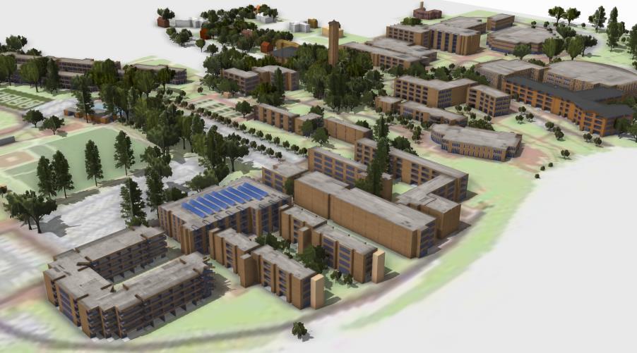
4 What is ArcGIS for 3D Cities? Ready-to-use Workflows, Tools, Models and Sample Data for Urban Management 3D Cities Information Model Create 3D City Base Layers Build a 3D Campus Map Visualize 3D Understand Zoning Economic Analysis - Solar potential, Manage Public Safety 3DCIM Rule Packages ETL/GP Tools Check out the workflows now: 4


5 3D Cities Information Model: Themes Built Environment - Created and actively managed by people - Structures, utilities, transportation networks, installations Legal Environment - Defines restrictions on land use - Land use zones, property ownership boundaries, regulations Natural Environment - Naturally occurring features on, above, or below the earth s surface - Land cover, subsurface geology, atmosphere/climate/weather 5

6 Built Environment: Buildings Connecting 2D and 3D Buildings The Building (Footprint object) carries most of the attribute information. BuildingShell represents the complete outer shell in 3D: - Procedural, or Measured BuildingShellParts can be used when separate processes for roofs, walls, and foundations are needed. 6
 - Routing - Asset")
7 Built Environment: Building Interiors (LoD4) Seamless usage of interior/exterior data Building interior data: - Building - Floor - Space - Structure - Entrance Used in analysis: - Query (where/who) - Routing - Asset allocation 7
8 Built Environment: Installations Things in the city other than buildings streets and water Street Furniture - Fire hydrants - Benches - Bike racks - Trash cans - Kiosks - Poles Vegetation - Trees 8


9 Legal Environment: Regulations Height Parcel Setbacks Attribute Type Setback Front Min 5, max 15 Setback Sides Min 8 Roof Type Flat Total Height Max 40 Site Coverage 0.6 FAR Max 1.2 Levels Above Ground Units per Parcel Max 4 Max 4 9


10 The Natural Environment Land Cover Subsurface Geology Wind & Weather Atmosphere & Pollution 10

11 3D City Base Layers Buildings 3D Buildings Multiple Levels of Detail LoD1 11

12 3D City Base Layers Buildings 3D Buildings Multiple Levels of Detail LoD2 12

13 3D City Base Layers Trees 3D Buildings Trees 13

14 3D City Base Layers Water Bodies 3D Buildings Trees Water Bodies 14


15 3D City Base Layers Basemap Skin 3D Buildings Trees Water Bodies Basemap Skin 15
16 3D City Base Layers Terrain 3D Buildings Trees Water Bodies Basemap Skin Terrain 16


17 3D City Base Layers Forms a 3D basemap 3D Buildings Trees Water Bodies Basemap Skin Terrain 17

18 3DCIM Interoperable with CityGML Use 3DCIM Perform ArcGIS Analytics Generate Procedural Content Create High-Performance 3D Visualisations Manage & Maintain Data Sets Use CityGML Exchange with Partners, Clients Provide Data in Open Infrastructure Satisfy Reporting Requirements
19 Lossless In/Out of 17 core CityGML Feature Classes Building, BuildingPart Roof-, Wall-, GroundSurface Room BuildingFurniture IntBuildingInstallation BuildingInstallation Opening, Window, Door FloorSurface InteriorWallSurface PlantCover SolitaryVegetationObject CityFurniture TrafficArea Address LandUse WaterBody & Surface 3D Cities Information Model in File GDB 19
20 Example Mapping for Building Building Building LoD1 <<includes>> Solid GroundPlate BuildingShell Level: 1..4 LoD2 <<includes>> Wall Roof <<aggregated to>> BuildingShellPart LoD3 Ext.Installation,.. <<includes>> InteriorWall InteriorStructure LoD4 InteriorInst. InteriorInst. Room,... InteriorSpace 20


21 Esri Base Scenes Earth Scene World Landscape scene City Scenes Campus/Interior Scenes 21

22 3D City Base Layers ArcGIS for Professionals Workflows 22


23 3D City Base Layers Building Height Tool Extruding footprints to LoD1 Using DSM/DEM (from LiDAR) 23


24 3D City Base Layers Tree Height Tool 24


25 Auto tree extraction from LiDAR plus Imagery Research coming to fruition Detail Overview Extracted millions of trees 25
26 LoD2 Building extraction Extracting roof shapes from DSM/DEM (from LiDAR) Two approaches being investigated Still at research stage 26

27 CityEngine - Procedural modeling 3D model creation using rules / algorithms Base geometry Procedural rules Base geometry Iterative refinement Final 3D model iteratively refine a design by creating more and more detail

28 Realistic city in CityEngine Extruded buildings Generated details Textured facades Streets Furniture Trees 28

29 Web Scene in Browser App 29

30 3D Base Scene in Browser App 30

31 3D Base Scene for Thematic Analysis 31


32 ArcGIS Web Scene 2.0 Streamed 3D Item on ArcGIS Online Mash-up of streaming 3D / 2D layers 3D Symbology 3D Labels 3D Scene Navigation 3D Environment

33 ArcGIS Desktop 3D at 10.3 ArcGIS Pro - Integrated experience to create, manage, and explore data in 2D & 3D - Create 3D data and scenes from 2D data - Built-in rules for buildings and trees support urban and campus visualization and analytics 33


34 Work in 3D anywhere Desktop Web Device 3D across the platform

35
New Methods for GeoDesign with ArcGIS and CityEngine. Dr. Özgür Ertac, Prof. Dr. Jörg Schaller, Cristina Mattos Tech. Uni. Munich, Esri Germany
 New Methods for GeoDesign with ArcGIS and CityEngine Dr. Özgür Ertac, Prof. Dr. Jörg Schaller, Cristina Mattos Tech. Uni. Munich, Esri Germany Agenda Evolution in 3D Introduction 3D Across the ArcGIS Platform
Data Conversion to I3S for 3D Modeling from CityGML. Christian Dahmen (con terra GmbH) Satish Sankaran (Esri)
 Satish Sankaran (Esri)") Data Conversion to I3S for 3D Modeling from CityGML Christian Dahmen (con terra GmbH) Satish Sankaran (Esri) 3D Across the ArcGIS Platform Manage Multiscale 3D Models 3D Geodesign ArcGIS for 3D Cities
Data Conversion to I3S for 3D Modeling from CityGML Christian Dahmen (con terra GmbH) Satish Sankaran (Esri) 3D Across the ArcGIS Platform Manage Multiscale 3D Models 3D Geodesign ArcGIS for 3D Cities
3D CARTOGRAPHY IN URBAN ENVIRONMENTS FOR MUNICIPAL ADMINISTRATIONS
 3D CARTOGRAPHY IN URBAN ENVIRONMENTS FOR MUNICIPAL ADMINISTRATIONS Andreea Calugaru Andreea Calugaru, Paula Florina Anca, Alexandru Vasile a.esri Romania 8 Roma, Bucharest, Romania 011774 0212339086, 0212339088,
GIS-based Smart Campus System using 3D Modeling
 GIS-based Smart Campus System using 3D Modeling Smita Sengupta GISE Advance Research Lab. IIT Bombay, Powai Mumbai 400 076, India smitas@cse.iitb.ac.in Concept of Smart Campus System Overview of IITB Campus
You Part of a Global Network of GIS Businesses. Your Work Making a Difference. Understanding Our World, with Web GIS, SDI and 3D
 Understanding Our World, with Web GIS, SDI and 3D Paul Hardy, Esri phardy@esri.com You Part of a Global Network of GIS Businesses XIV International User Conference of GeoInformation Systems & Remote Sensing,
ArcGIS Urban: An Introduction. Lisa Staehli ArcGIS Urban Team Product Development Brooks Patrick ArcGIS Urban Team Business Development
 ArcGIS Urban: An Introduction Lisa Staehli ArcGIS Urban Team Product Development Brooks Patrick ArcGIS Urban Team Business Development Our Cities Are Facing Massive Challenges Our Cities Are Facing Massive
ArcGIS Pro 3D Workflows. Zena Pelletier
 ArcGIS Pro 3D Workflows Zena Pelletier 3D as a GIS capability Core part of the platform Desktop Web Device Combine 2D and 3D in the same web GIS architecture Reuse dynamic services across clients Securely
Introduction to Portal for ArcGIS
 Introduction to Portal for ArcGIS Derek Law Product Management March 10 th, 2015 Esri Developer Summit 2015 Agenda Web GIS pattern Product overview Installation and deployment Security and groups Configuration
Strategies for Integrating CAD and BIM in ArcGIS. Don Kuehne Esri 3D Product Manager: CAD/BIM/AEC
 Strategies for Integrating CAD and BIM in ArcGIS Don Kuehne Esri 3D Product Manager: CAD/BIM/AEC CAD Digital Drawing CAD in ArcGIS Desktop CAD in Desktop CAD as Data CAD as a Map EXPORT TO CAD Create and
Portal for ArcGIS: An Introduction
 Portal for ArcGIS: An Introduction Derek Law Esri Product Management Esri UC 2014 Technical Workshop Agenda Web GIS pattern Product overview Installation and deployment Security and groups Configuration
Esri s Living Atlas of the World Community Maps
 Esri s Living Atlas of the World Community Maps Seth Sarakaitis Wednesday May 7, 2014 ArcGIS Living Atlas Concept Living Atlas Content Tour Contributing to the Living Atlas (Community Maps) Seth Sarakaitis
Introduction to Portal for ArcGIS. Hao LEE November 12, 2015
 Introduction to Portal for ArcGIS Hao LEE November 12, 2015 Agenda Web GIS pattern Product overview Installation and deployment Security and groups Configuration options Portal for ArcGIS + ArcGIS for
What is GIS and How Can It Help Me?
 esri European User Conference Madrid 2011 What is GIS and How Can It Help Me? Jaime Nieves Ignacio Vázquez esri spain «Knowing where things are, and why, is essential to rational decision making.» Jack
Esri Overview for Mentor Protégé Program:
 Agenda Passionate About Helping You Succeed Esri Overview for Mentor Protégé Program: Northrop Grumman CSSS Jeff Dawley 3 September 2010 Esri Overview ArcGIS as a System ArcGIS 10 - Map Production - Mobile
Spatial Analysis with Web GIS. Rachel Weeden
 Spatial Analysis with Web GIS Rachel Weeden Agenda Subhead goes here Introducing ArcGIS Online Spatial Analysis Workflows Scenarios Other Options Resources ArcGIS is a Platform Making mapping and analytics
What Would John Snow Do (Today)? Part 1
? Part 1") What Would John Snow Do (Today)? Part 1 Tanya Bigos and Derek Law @Tanyabigos @GIS_Bandit Thurs Oct 19 th, 2017 Outline Overview of the ArcGIS Platform Whiteboard discussion Summary Questions A Whole New
What Would John Snow Do (Today)? Part 1 Tanya Bigos and Derek Law @Tanyabigos @GIS_Bandit Thurs Oct 19 th, 2017 Outline Overview of the ArcGIS Platform Whiteboard discussion Summary Questions A Whole New
Features and Benefits
 Autodesk LandXplorer Features and Benefits Use the Autodesk LandXplorer software family to help improve decision making, lower costs, view and share changes, and avoid the expense of creating physical
Demystifying ArcGIS Online. Karen Lizcano Esri
 Demystifying ArcGIS Online Karen Lizcano Esri An Integrated Web GIS Platform Desktop Web Device Powered by Services Managed via Portal Access from any Device Portal Server Online Content and Services ArcGIS
The University of Arizona Enterprise GIS. CFTA 2016 Facilities Geospatial Technologies Showcase
 The University of Arizona Enterprise GIS CFTA 2016 Facilities Geospatial Technologies Showcase Main Campus: Tucson, Arizona Founded: 1885 Number of Buildings: 227 GSF: 9.4 million Acres: 393 Total Students:
Your Perfect 3D World (BIM and GIS Integrated)
") Your Perfect 3D World (BIM and GIS Integrated) June 2015 Larisa Kruger Background Larisa Kruger- Enterprise GIS Manager FITS- Facilities Information Technology Services 2 years (GIS for 15) 2 FTE, 4 students
Your Perfect 3D World (BIM and GIS Integrated) June 2015 Larisa Kruger Background Larisa Kruger- Enterprise GIS Manager FITS- Facilities Information Technology Services 2 years (GIS for 15) 2 FTE, 4 students
Working with ArcGIS Online
 Esri International User Conference San Diego, CA Technical Workshops July 12, 2011 Working with ArcGIS Online Bern Szukalski, Deane Kensok Topics for this Session ArcGIS Online Overview ArcGIS Online Content
ArcGIS is Advancing. Both Contributing and Integrating many new Innovations. IoT. Smart Mapping. Smart Devices Advanced Analytics
 ArcGIS is Advancing IoT Smart Devices Advanced Analytics Smart Mapping Real-Time Faster Computing Web Services Crowdsourcing Sensor Networks Both Contributing and Integrating many new Innovations ArcGIS
SCAUG Community Maps Building a Living Atlas of the World
 SCAUG Community Maps Building a Living Atlas of the World Mark Stewart Topics: SCAUG ArcGIS Online Overview Community Maps Overview Community Maps Workflow Update Process Utilizing Your Contribution Community
Bentley Map V8i (SELECTseries 3)
") Bentley Map V8i (SELECTseries 3) A quick overview Why Bentley Map Viewing and editing of geospatial data from file based GIS formats, spatial databases and raster Assembling geospatial/non-geospatial data
Bentley Map V8i (SELECTseries 3) A quick overview Why Bentley Map Viewing and editing of geospatial data from file based GIS formats, spatial databases and raster Assembling geospatial/non-geospatial data
Geo-Enabling Digital India. 15 th Esri India User Conference GIS and Smart Cities
 15 th Esri India User Conference 2014 GIS and Smart Cities 15 th Esri India User Conference 2014 GIS and Smart Cities Agendra Kumar President, Esri India Our World Is Facing Serious Challenges Our World
EnvSci 360 Computer and Analytical Cartography
 EnvSci 360 Computer and Analytical Cartography Lecture 7 Mapping Images, Surfaces, and 3-D Data Brief Overview of Imagery What is Imagery? A spatial data model that defines space as an array of equally
CITYGML MODELLING FOR SINGAPORE 3D NATIONAL MAPPING
 CITYGML MODELLING FOR SINGAPORE 3D NATIONAL MAPPING K. H. Soon* and V. H. S. Khoo Land Survey Division, Singapore Land Authority, 55 Newton Road, #12-01, 307987 Singapore - (soon_kean_huat, victor_khoo)@sla.gov.sg
VISUALIZING THE SMART CITY 3D SPATIAL INFRASTRUCTURE GEOSMART ASIA- 30 SEP, 2015
 www.aamgroup.com VISUALIZING THE SMART CITY 3D SPATIAL INFRASTRUCTURE GEOSMART ASIA- 30 SEP, 2015 Agenda AAM What is a Smart City? Data Acquisition 3D Modelling Benefits Questions AAM AAM is a Geospatial
Leveraging Web GIS: An Introduction to the ArcGIS portal
 Leveraging Web GIS: An Introduction to the ArcGIS portal Derek Law Product Management DLaw@esri.com Agenda Web GIS pattern Product overview Installation and deployment Configuration options Security options
ArcGIS. for Server. Understanding our World
 ArcGIS for Server Understanding our World ArcGIS for Server Create, Distribute, and Manage GIS Services You can use ArcGIS for Server to create services from your mapping and geographic information system
Portal for ArcGIS: An Introduction. Catherine Hynes and Derek Law
 Portal for ArcGIS: An Introduction Catherine Hynes and Derek Law Agenda Web GIS pattern Product overview Installation and deployment Configuration options Security options and groups Portal for ArcGIS
Local Government Basemaps using ArcGIS
 Local Government Basemaps using ArcGIS Steve Grisé Scott Oppmann Tuesday, July 14, 10:15-11:30am SDCC 30B Topics Basemaps for Local Government Essential Application-Driven New Ideas Design Strategies Discussion
These modules are covered with a brief information and practical in ArcGIS Software and open source software also like QGIS, ILWIS.
 Online GIS Training and training modules covered are: 1. ArcGIS, Analysis, Fundamentals and Implementation 2. ArcGIS Web Data Sharing 3. ArcGIS for Desktop 4. ArcGIS for Server These modules are covered
You are Building Your Organization s Geographic Knowledge
 You are Building Your Organization s Geographic Knowledge And Increasingly Making it Available Sharing Data Publishing Maps and Geo-Apps Developing Collaborative Approaches Citizens Knowledge Workers Analysts
What s New in Collector for ArcGIS (Aurora)
") What s New in Collector for ArcGIS (Aurora) Derek Law (dlaw@esri.com) Esri Apps Product Management @GIS_Bandit Oct 10 th, 2018 Agenda Product overview Use cases Preparing data for Collector for ArcGIS
What s New in Collector for ArcGIS (Aurora) Derek Law (dlaw@esri.com) Esri Apps Product Management @GIS_Bandit Oct 10 th, 2018 Agenda Product overview Use cases Preparing data for Collector for ArcGIS
Exelis and Esri Technologies for Defense and National Security. Cherie Muleh
 Exelis and Esri Technologies for Defense and National Security Cherie Muleh Cherie.Muleh@exelisinc.com ENVI IMAGERY AND DATA BECOME KNOWLEDGE > Add information from imagery to your GIS > Automated workflows
Aileen Buckley, Ph.D. and Charlie Frye
 An Information Model for Maps: Towards Production from GIS Databases Aileen Buckley, Ph.D. and Charlie Frye Researchers, ESRI GIS vs. cart GIS Outline of the presentation Introduction Differences between
Introduction to ArcGIS Maps for Office. Greg Ponto Scott Ball
 Introduction to ArcGIS Maps for Office Greg Ponto Scott Ball Agenda What is Maps for Office? Platform overview What are Apps for the Office? ArcGIS Maps for Office features - Visualization - Geoenrichment
From CityGML to Energy ADE - Workflow
 From CityGML to Energy ADE - Workflow KIT Universität von Baden-Württemberg und nationales Forschungszentrum der Helmholtz Gemeinschaft www.kit.edu Workflow overview CityGML import Geometric / semantic
A Vision for ArcGIS Applying Geography Everywhere
 A Vision for ArcGIS Applying Geography Everywhere WELCOME PURPOSE A Network of GIS Professionals Are Awakening the World to the Power of Web GIS You Your WORK Making a Difference Your Work Open Maps and
The Pace of Change Is Accelerating Creating Many Challenges
 VISION The Pace of Change Is Accelerating Creating Many Challenges Evidence Threatening Our Natural World and Our Future as Humans Social Conflict Mass Migration Ocean Acidification Food Population Urbanization
Web GIS: Architectural Patterns and Practices. Shannon Kalisky Philip Heede
 Web GIS: Architectural Patterns and Practices Shannon Kalisky Philip Heede Web GIS Transformation of the ArcGIS Platform Desktop Apps Server GIS Web Maps Web Scenes Layers Web GIS Transformation of the
DATA APPLIANCE FOR ARCGIS
 DATA APPLIANCE FOR ARCGIS Data Appliance for ArcGIS Provides Access to Multi-Scale Basemaps Down to Medium Scale Levels Worldwide And Large Scale for Most of the World The Data Appliance includes Several
Enabling Web GIS. Dal Hunter Jeff Shaner
 Enabling Web GIS Dal Hunter Jeff Shaner Enabling Web GIS In Your Infrastructure Agenda Quick Overview Web GIS Deployment Server GIS Deployment Security and Identity Management Web GIS Operations Web GIS
Geospatial Fire Behavior Modeling App to Manage Wildfire Risk Online. Kenyatta BaRaKa Jackson US Forest Service - Consultant
 Geospatial Fire Behavior Modeling App to Manage Wildfire Risk Online Kenyatta BaRaKa Jackson US Forest Service - Consultant Fire Behavior Modeling and Forest Fuel Management Modeling Fire Behavior is an
HIGH RESOLUTION BASE MAP: A CASE STUDY OF JNTUH-HYDERABAD CAMPUS
 HIGH RESOLUTION BASE MAP: A CASE STUDY OF JNTUH-HYDERABAD CAMPUS K.Manjula Vani, Abhinay Reddy, J. Venkatesh, Ballu Harish and R.S. Dwivedi ABSTRACT The proposed work High Resolution Base map: A Case study
What is the Living Atlas for ArcGIS and How Can you be Involved?
 Federal GIS Conference February 9 10, 2015 Washington, DC What is the Living Atlas for ArcGIS and How Can you be Involved? Clint Brown Deane Kensok Agenda Introduction to Living Atlas - Transformation
3D City Models in SketchUp
 3D City Models in SketchUp 1 Features & Pricing Date: 03/03/2017, Version 2.7.0.785 1 Features The CityEditor is not an independent program but an extension for Trimble SketchUp allowing the import of
How to Construct Urban Three Dimensional GIS Model based on ArcView 3D Analysis
 How to Construct Urban Three Dimensional GIS Model based on ArcView 3D Analysis Ko Ko Lwin Division of Spatial Information Science Graduate School of Life and Environmental Sciences University of Tsukuba
Symbolisation of 3D city models for online visualisation
 Symbolisation of 3D city models for online visualisation Bo Mao, Jie Cao Jiangsu Provincial ebusiness Lab, Nanjing University of Finance and Economics, No.128 Tielu North Road, Nanjing, 210003 Telephone:
Overview of CityGML. Dave Capstick, Ordnance Survey Research Department
 Overview of CityGML Dave Capstick, Ordnance Survey Research Department Introduction Why is citygml necessary CityGML development who is responsible? Ordnance Surveys interest 3D modelling basic concepts
An Introduction to the Community Maps Information Model
 Esri International User Conference July 23 27 San Diego Convention Center An Introduction to the Community Maps Information Model Seth Sarakaitis Agenda Overview of Community Maps Program Information Models
Imagery and the Location-enabled Platform in State and Local Government
 Imagery and the Location-enabled Platform in State and Local Government Fred Limp, Director, CAST Jim Farley, Vice President, Leica Geosystems Oracle Spatial Users Group Denver, March 10, 2005 TM TM Discussion
Web GIS & ArcGIS Pro. Zena Pelletier Nick Popovich
 Web GIS & ArcGIS Pro Zena Pelletier Nick Popovich Web GIS Transformation of the ArcGIS Platform Desktop Apps GIS Web Maps Web Scenes Layers Evolution of the modern GIS Desktop GIS (standalone GIS) GIS
Enabling ENVI. ArcGIS for Server
 Enabling ENVI throughh ArcGIS for Server 1 Imagery: A Unique and Valuable Source of Data Imagery is not just a base map, but a layer of rich information that can address problems faced by GIS users. >
Leveraging ArcGIS Online Elevation and Hydrology Services. Steve Kopp, Jian Lange
 Leveraging ArcGIS Online Elevation and Hydrology Services Steve Kopp, Jian Lange Topics An overview of ArcGIS Online Elevation Analysis Using Elevation Analysis Services in ArcGIS for Desktop Using Elevation
The INSPIRE Building Model for Energy Applications
 The INSPIRE Building Model for Energy Applications 1 Gerhard Gröger Institute for Geodesy and Geoinformation University of Bonn, Germany 2nd Joint SIG 3D and OGC Workshop - CityGML EnergyADE for building
ArcGIS 10.1 An Overview of the System
 ArcGIS 10.1 An Overview of the System ArcGIS 10.1 An Overview of the System Damian Spangrud Director of Solutions, Esri Redlands, CA USA ArcGIS 10.1 Web Cloud Online Mobile Enterprise Desktop ArcGIS 10.1
ArcGIS Enterprise: What s New. Philip Heede Shannon Kalisky Melanie Summers Sam Williamson
 ArcGIS Enterprise: What s New Philip Heede Shannon Kalisky Melanie Summers Sam Williamson ArcGIS Enterprise is the new name for ArcGIS for Server What is ArcGIS Enterprise ArcGIS Enterprise is powerful
Visualizing Big Data on Maps: Emerging Tools and Techniques. Ilir Bejleri, Sanjay Ranka
 Visualizing Big Data on Maps: Emerging Tools and Techniques Ilir Bejleri, Sanjay Ranka Topics Web GIS Visualization Big Data GIS Performance Maps in Data Visualization Platforms Next: Web GIS Visualization
OFWIM 2017 Annual Conference What Does Web GIS Really Mean for Fish and Wildlife Agencies?
 Content Open Mapping OFWIM 2017 Annual Conference What Does Web GIS Really Mean for Fish and Wildlife Agencies? Imagery Spatial Analysis Mike Bialousz, Esri 3D Data Exploration Real-Time Apps Visualization
ArcGIS Pro: Essential Workflows STUDENT EDITION
 ArcGIS Pro: Essential Workflows STUDENT EDITION Copyright 2018 Esri All rights reserved. Course version 6.0. Version release date August 2018. Printed in the United States of America. The information contained
NR402 GIS Applications in Natural Resources
 NR402 GIS Applications in Natural Resources Lesson 1 Introduction to GIS Eva Strand, University of Idaho Map of the Pacific Northwest from http://www.or.blm.gov/gis/ Welcome to NR402 GIS Applications in
Web GIS Deployment for Administrators. Vanessa Ramirez Solution Engineer, Natural Resources, Esri
 Web GIS Deployment for Administrators Vanessa Ramirez Solution Engineer, Natural Resources, Esri Agenda Web GIS Concepts Web GIS Deployment Patterns Components of an On-Premises Web GIS Federation of Server
Applied Cartography and Introduction to GIS GEOG 2017 EL. Lecture-2 Chapters 3 and 4
 Applied Cartography and Introduction to GIS GEOG 2017 EL Lecture-2 Chapters 3 and 4 Vector Data Modeling To prepare spatial data for computer processing: Use x,y coordinates to represent spatial features
CAD: Introduction to using CAD Data in ArcGIS. Kyle Williams & Jeff Reinhart
 CAD: Introduction to using CAD Data in ArcGIS Kyle Williams & Jeff Reinhart What we will accomplish today Overview of ArcGIS CAD Support Georeferencing CAD data for ArcGIS How Mapping Specification for
SUPPORTS SUSTAINABLE GROWTH
 DDSS BBUUN NDDLLEE G E O S P AT I A L G O V E R N A N C E P A C K A G E SUPPORTS SUSTAINABLE GROWTH www.digitalglobe.com BRISBANE, AUSTRALIA WORLDVIEW-3 30 CM International Civil Government Programs US
The Conversion from CityGML to 3D Property Units
 Shen YING, Fengzan JIN, Renzhong GUO, Lin LI, Jie YANG and Yujie ZHOU, China Key words: 3D Property Unit, CityGML, 3D Cadastre, Data Conversion SUMMARY Due to the fast growth of building construction technology
3D City GIS. Agenda. Why 3D City GIS? What does 3D City GIS mean?
 3D City GIS 1 of 60 WWW.BENTLEY.COM Ben Fredericque, Product Manager, Geospatial Agenda Why 3D City GIS? What does 3D City GIS mean? 2 of 60 WWW.BENTLEY.COM Sydney, Australia, 11 16 April 2010 1 Why 3D
Building Thermal Energy Simulations Supported by the CityGML Energy ADE
 Building Thermal Energy Simulations Supported by the CityGML Energy ADE INSTITUT FÜR AUTOMATION UND ANGEWANDTE INFORMATIK KIT Die Forschungsuniversität in der Helmholtz-Gemeinschaft www.kit.edu Agenda
Configure map pop-up windows Save a map Configure the map symbology
 CHAPTER 1 Introducing GIS Exercise objectives 1a: Explore ArcGIS Online Explore a public map Sign in and join an organization Configure map pop-up windows Save a map Configure the map symbology What is
September 2016 New ArcGIS Solutions
 September 2016 New ArcGIS Solutions Hydroelectric https://profservices.maps.arcgis.com/apps/mapjournal/index.html?appid=0ef98f74f8fb4f9da88 1adc521e1c90f Adopta Engage the public in the maintenance and
Creating Basemaps to Manage Buildings and Facilities
 Esri International User Conference San Diego, California Technical Workshops July 26, 2012 Creating Basemaps to Manage Buildings and Facilities Mark Stewart and Tamara Yoder Topics for this Session Overview
Semantic 3D City Models for Strategic Energy Planning in Berlin & London
 Semantic 3D City Models for Strategic Energy Planning in Berlin & London The content of this presentation is provided by Zhihang Yao, Robert Kaden, and Thomas H. Kolbe Chair of Geoinformatics, TU München
Living Atlas: Road Ahead. Deane Kensok Sean Breyer
 Living Atlas: Road Ahead Deane Kensok Sean Breyer Workshop Agenda Subhead Here Overview of the Living Atlas Esri Content Portfolio - Overview - Road Map for 2017 and Beyond - Demos: Previews of Online
Esri User Conference 2018 Video Topics
 Esri User Conference 2018 Video Topics 3D GIS 3D Across ArcGIS 3D Analysis Tools in ArcGIS Pro 3D Cartographic Techniques: An Introduction 3D Data: Lidar Point Clouds and 3D Mesh 3D Feature and Sub-Surface
Sustainability Adaptation Transparency Accountability. $400 FBC of fuel.
 Sustainability Adaptation Transparency Accountability $400 FBC of fuel. We need a sustainability platform Tools for organization, collaboration, policy, data collection, storage, analysis, understanding,
ArcGIS for Local Government. Local Government. Title Placed Here
 ArcGIS for ArcGIS for Local Government Local Government Title Placed Here ArcGIS for Local Government solutions.arcgis.com/local-government Copyright 2016 Esri. All rights reserved. 151760 G73000 Address
Lecture 2. Introduction to ESRI s ArcGIS Desktop and ArcMap
 Lecture 2 Introduction to ESRI s ArcGIS Desktop and ArcMap Outline ESRI What is ArcGIS? ArcGIS Desktop ArcMap Overview Views Layers Attribute Tables Help! Scale Tips and Tricks ESRI Environmental Systems
So, in this presentation, you can sit back and focus on the concepts and
 CHARLIE 15 MINUTES ABSTRACT In this session, we show how you can use a map template and other resources from the Resource Centers to complete your work faster and easier. We will touch on managing and
esri.com/apps Copyright 2017 Esri. All rights reserved.
 ArcGIS Apps esri.com/apps Copyright 2017 Esri. All rights reserved. 159913 G79379 ArcGIS Apps Survey123 for ArcGIS Included with ArcGIS Survey123 for ArcGIS Create survey style forms to capture accurate
Data Aggregation with InfraWorks and ArcGIS for Visualization, Analysis, and Planning
 Data Aggregation with InfraWorks and ArcGIS for Visualization, Analysis, and Planning Stephen Brockwell President, Brockwell IT Consulting, Inc. Join the conversation #AU2017 KEYWORD Class Summary Silos
Base Maps: Creating, Using & Participating
 Base Maps: Creating, Using & Participating Michael Fashoway & Erin Geraghty Montana Base Map Service Center 2010 MAGIP Technical Session October 28, 2010 What is a Base Map? Using a Base Map Creating a
ArcGIS for Desktop. ArcGIS for Desktop is the primary authoring tool for the ArcGIS platform.
 ArcGIS for Desktop ArcGIS for Desktop ArcGIS for Desktop is the primary authoring tool for the ArcGIS platform. Beyond showing your data as points on a map, ArcGIS for Desktop gives you the power to manage
ArcGIS Web Tools, Templates, and Solutions for Defence & Intelligence. Renee Bernstein Esri Solutions Engineer
 ArcGIS Web Tools, Templates, and Solutions for Defence & Intelligence Renee Bernstein Esri Solutions Engineer ArcGIS Solutions Includes 450+ Industry Focused Apps and Capabilities Organized by 9 Primary
Incorporating ArcGIS Pro in your Curriculum
 AAG, Boston 2017 April 5, 2017 Incorporating ArcGIS Pro in your Curriculum Geri Miller Agenda Concerns Acknowledged Learning curve ArcGIS Pro does not have all the tools (perception) Licensing and offline
GIS-based Smart Campus System using 3D Modeling
 GIS-based Smart Campus System using 3D Modeling Hardik Panchal & Rizwan Khan, Smita Sengupta, GISE Advance Lab, Indian Institute of Technology, Bombay, India N.L. Sarda, Dept. Of Computer Science, Indian
Steve Pietersen Office Telephone No
 Steve Pietersen Steve.Pieterson@durban.gov.za Office Telephone No. 031 311 8655 Overview Why geography matters The power of GIS EWS GIS water stats EWS GIS sanitation stats How to build a GIS system EWS
IMPERIAL COUNTY PLANNING AND DEVELOPMENT
 IMPERIAL COUNTY PLANNING AND DEVELOPMENT GEODATABASE USER MANUAL FOR COUNTY BUSINESS DEVELOPMENT GIS June 2010 Prepared for: Prepared by: County of Imperial Planning and Development 801 Main Street El
CityGML in Detail Part 1
 CityGML in Detail Part 1 Prof. Dr. Thomas H. Kolbe Institute for Geodesy and Geoinformation Science Berlin University of Technology kolbe@igg.tu-berlin.de May 2008 EduServ6 Course on CityGML Copyright
June 19 Huntsville, Alabama 1
 June 19 Huntsville, Alabama 1 Real-Time Geospatial Data: The Fusion of PI and ArcGIS Enabling Smarter Facilities Management OSIsoft and Esri Mapping and Location Analytics Platform Supporting Your Use
User Requirements Gathering for a National 3D Mapping Product in the United Kingdom
 User Requirements Gathering for a National 3D Mapping Product in the United Kingdom Session 4 EuroSDR/VOLTA SESSION: NMCAS I (3D GEOINFORMATION FOR NATIONAL AND CADASTRAL MAPPING AGENCIES I) th 13 3DGeoInfo
GPS Mapping with Esri s Collector App. What We ll Cover
 GPS Mapping with Esri s Collector App Part 1: Overview What We ll Cover Part 1: Overview and requirements Part 2: Preparing the data in ArcGIS for Desktop Part 3: Build a web map in ArcGIS Online Part
3D Urban Information Models in making a smart city the i-scope project case study
 UDC: 007:528.9]:004; 007:912]:004; 004.92 DOI: 10.14438/gn.2014.17 Typology: 1.04 Professional Article 3D Urban Information Models in making a smart city the i-scope project case study Dragutin PROTIĆ
<Insert Picture Here> Oracle Spatial 11g. Dr. Siva Ravada
 Oracle Spatial 11g Dr. Siva Ravada New in Oracle Spatial 11g 3D Support Spatial Web Services Network Data Model GeoRaster Performance Improvements 3D Applications Location-based services
DP Project Development Pvt. Ltd.
 Dear Sir/Madam, Greetings!!! Thanks for contacting DP Project Development for your training requirement. DP Project Development is leading professional training provider in GIS technologies and GIS application
What s New. August 2013
 What s New. August 2013 Tom Schwartzman Esri tschwartzman@esri.com Esri UC2013. Technical Workshop. What is new in ArcGIS 10.2 for Server ArcGIS 10.2 for Desktop Major Themes Why should I use ArcGIS 10.2
ArcGIS for INSPIRE. Marten Hogeweg
 ArcGIS for INSPIRE Marten Hogeweg Please Take Our Survey on the App Download the Esri Events app and find your event Select the session you attended Scroll down to find the feedback section Complete answers
When Map Quality Matters
 When Map Quality Matters 50% 25% Powerful geospatial mapping tools for Adobe Creative Cloud and offline map solutions for mobile devices 20% When Map Quality Matters 10% We re focused on creating powerful
CityGML in Detail Part 2
 CityGML in Detail Part 2 Prof. Dr. Thomas H. Kolbe Institute for Geodesy and Geoinformation Science Berlin University of Technology kolbe@igg.tu-berlin.de May 2008 EduServ6 Course on CityGML Copyright