Semantic 3D City Models for Strategic Energy Planning in Berlin & London
|
|
|
- Dwayne Wilkerson
- 6 years ago
- Views:
Transcription
1 Semantic 3D City Models for Strategic Energy Planning in Berlin & London The content of this presentation is provided by Zhihang Yao, Robert Kaden, and Thomas H. Kolbe Chair of Geoinformatics, TU München The presentation is given by Tatjana Kutzner Chair of Geoinformatics, TU München, March 27th, 2014 E&U DWG, OGC TC Meeting, Crystal City, Arlington, Virginia, USA
2 Motivation Climate and environmental policy measures involve a reorganisation of the energy supply in many cities Buildings account for 40% of the total energy demand A cut-down on energy be achieved through Prediction of the energy demand Location of currently unused / renewable energy sources (solar heat & photovoltaics, wind power, geothermal energy) Use of a geospatial model Energy Atlas Why is a 3D model required? To estimate the energy demand at building level (heated building volume, number of windows, etc.) To perform aggregations on the buildings 2


3 Energy Atlas Berlin and London Concept Creation of an integrative, common ontology For spatial-semantic representation of the urban space Including energy-relevant information from different disciplines Based on the semantic information model of CityGML The virtual 3D city models of Berlin and London serve as data base 3

4 The Aim of the Energy Atlas Berlin Tool for holistic energy planning Analysis and representation of the actual state of objects and their energyrelevant parameters within a city Investigation and balancing of options and measures Decision support for various measures by visualizing the effects Data backbone for common analysis and simulations Estimation of heating energy and electricity demands Energetic building characteristics and rehabilitation potentials Design of an optimal electricity network Location planning for recharge facilities for e-mobility Use of geothermal and solar energy potentials 4


5 Spatio-Semantic Decomposition of Urban Space Many urban assets are directly related to physical objects Physical objects are thematically classified into discrete topographic objects 3D decomposition of urban space In different, discrete scale levels (LODs) City is decomposed into discrete objects with clear semantics and defined spatial and thematic properties Buildings, roads, railways, terrain, water bodies, vegetation, bridges Objects may be further decomposed [Images: Paul Cote, Harvard Graduate School of Design] 5
6 City Geography Markup Language (CityGML) Application independent geospatial information model for semantic 3D city and landscape models comprises different thematic fields (buildings, vegetation, water, terrain, traffic, tunnels, bridges etc.) International standard of the Open Geospatial Consortium V1.0.0 adopted in 08/2008; V2.0.0 adopted in 3/2012 Data model (UML) + Exchange format (based on GML3) CityGML represents 3D geometry, 3D topology, semantics, and appearance in 5 discrete scales (Levels of Detail, LOD) 6


7 Information Fusion of Different Disciplines Geothermal potential analysis Infrastructure analysis Energy savings potential analysis Energy Atlas Energy demand analysis Solar potential analysis 7
8 Correlation: Building and Energy Demand Estimates of the energy demands are based on the hypothesis that there is a strong correlation between the building characteristics and the needed energy Building Information Geometry Usage Construction Rehabilitation Residents Apartments Climate and environment conditions Correlation Energy Demand Electricity Warm Water Heating 8


9 Estimation of Heating Energy Demand Building-specific and city-wide calculation based on algorithms of the Institut Wohnen und Umwelt (IWU) Based on the virtual 3D city model and official geobase data within the Energy Atlas Berlin Building Information Geometry Usage Construction Rehabilitation Residents Apartments Climate and environment conditions Correlation Energy Demand Electricity Warm Water Heating 9
10 Estimation of Electricity Demand Building-specific and city-wide estimation based on average electricity consumption statistics for households Based on the virtual 3D city model and official geobase data within the Energy Atlas Berlin Building Information Geometry Usage Construction Rehabilitation Residents Apartments Climate and environment conditions Correlation Energy Demand Electricity Warm Water Heating 10
11 Estimation of Energy Demand for Warm Water Building-specific and city-wide calculation bases on algorithms of the Institut Wohnen und Umwelt (IWU) Based on the virtual 3D city model and official geobase data within the Energy Atlas Berlin Building Information Geometry Usage Construction Rehabilitation Residents Apartments Climate and environment conditions Correlation Energy Demand Electricity Warm Water Heating 11


12 Solar Potential Analysis for Buildings Estimation of the energy production potentials for PV and solar thermal, required investments and achievable CO 2 reductions Done for each of the 550,000 buildings on the level of roof surface segments 12


13 Heating Energy Demand and Solar Thermal Potentials on the Building Level 13


14 Solar Thermal Potential on District Level 14

15 Multi-level System Architecture End Users Citizens Housing Companies Cities Energy Supplier Application Level App 1: Decision support for investment in construction Calculation Engine GUI Extract from central Database App 2: Reporting of renewable energy production possibilities GUI Extract from central Database Calculation Engine many more Apps Information Backbone & Simulation Integration Solar Potential Analysis 3D City Model + Energy ADE Urban Analytics Toolkit Heating Consumption Estimation Common Urban Information Model Energy Demand Calculation many more modules 15


16 Realisation using Cloud Services Administrator Level Cloud Service Application Level 3D Desktop Application (e.g. Google Earth) KML/COLLADA Exporter SPSHG* & SPSHI** Upload KML/KMZ 3D-Visualisation Model link Configuration Request Response Request Response 3D-Webclient Export 3D City Database Import Spreadsheet Download / Upload link Thematic Data Request Response *Spreadsheet Generator **Spreadsheet Importer 16


17 Interactive 3D Exploration Visualisation model Thematic data Logical join via GMLID KML file via Dropbox Google Spreadsheet 17

18 Demo 3D City Model Berlin Information about energy demand for each building 18


19 Demo 3D City Model Berlin Aggregated energy demand of several buildings 19


20 Demo Use of the 3D Web Client in Berlin Ad hoc estimation of the heating energy demand Interactive modification of parameters by the planner E.g. deegree of heat insulation Immediate recalculation of the energy demand values before modification after modification Kutzner, Yao, Kaden, Sindram, Kolbe: Working with Semantic 3D City Models over the Web - Use Case Energy Planning 20


21 Demo 3D City Model Berlin Information about each statistical block 21


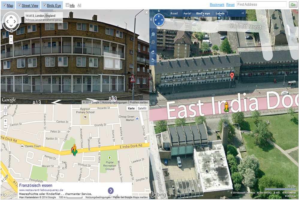
22 Demo 3D City Model Berlin Visual inspection of a building using the mash-up project Dual Maps ( 22


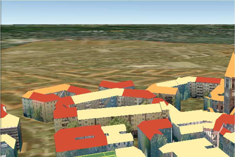
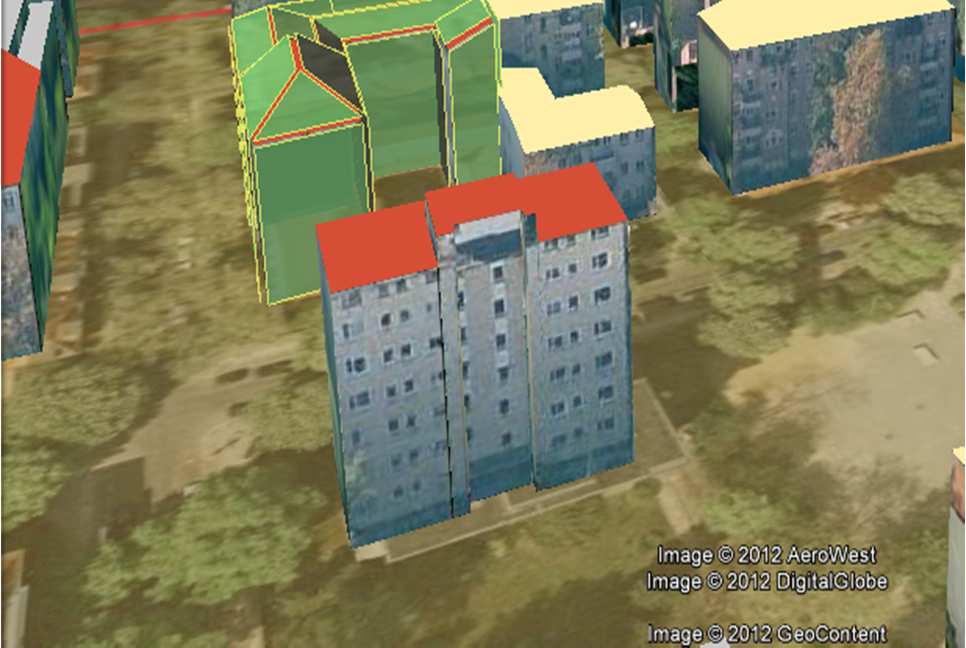
23 Demo 3D City Model London Information about energy demand for each building 23
24 Energy Simulation Source: Scenario 1 : Original State 24 Giorgio Agugiaro Progetto EnerCity
25 Energy Simulation Source: Scenario 2 : Current State 25 Giorgio Agugiaro Progetto EnerCity
26 Energy Simulation Source: Scenario 3 : Total Refurbishment 26 Giorgio Agugiaro Progetto EnerCity
27 Conclusions Energy Atlas Berlin Provision of a common information model for the holistic environmental and energy planning based on CityGML Data base: virtual city models of London and Berlin plus specialized information Basis for multidisciplinary analysis and simulation Analyzes and simulations Investigation of the actual state, e.g. estimation of energy demands Investigation of energy-saving and production potentials Comparison of the energy demands and potentials on various aggregation levels 27
28 Conclusions Multi-layered system architecture and cloud-based 3D web client allow for Energy simulations using complex-structured semantic 3D city models Simple and intuitive access to 3D city models for users through reduction of the complexity of the semantic city models necessary Outlook: Stronger abstraction from concrete products (such as Dropbox, Google Earth & Spreadsheets) Semantic 3D City Model for Strategic Energy Planning in Berlin & London 28
Semantic 3D City Models for Urban Information Fusion and City Lifecycle Management
 Technische Universität Berlin Semantic 3D City Models for Urban Information Fusion and City Lifecycle Management Thomas H. Kolbe Institute for Geodesy & Geoinformation Science Technische Universität Berlin
3D-SDI contribution to energy-efficient cities 3D CityModels for Energy Demand Simulation
 HFT Research 3D-SDI contribution to energy-efficient cities 3D CityModels for Energy Demand Simulation Claudia Schulte, HFT Stuttgart, Institute for Applied Research Prof. Dr. Volker Coors, HFT Stuttgart,
GIS-based Smart Campus System using 3D Modeling
 GIS-based Smart Campus System using 3D Modeling Smita Sengupta GISE Advance Research Lab. IIT Bombay, Powai Mumbai 400 076, India smitas@cse.iitb.ac.in Concept of Smart Campus System Overview of IITB Campus
Web-based Exploration of and Interaction with Large and Deeply Structured Semantic 3D City Models using HTML5 and WebGL
 Web-based Exploration of and Interaction with Large and Deeply Structured Semantic 3D City Models using HTML5 and WebGL KANISHK CHATURVEDI 1, ZHIHANG YAO 2 & THOMAS H. KOLBE 1 Abstract: The aim of the
Developing 3D Geoportal for Wilayah Persekutuan Iskandar
 Developing 3D Geoportal for Wilayah Persekutuan Iskandar Dionnald Beh BoonHeng and Alias Abdul Rahman Department of Geoinformatics, Faculty of Geoinformation Engineering and Sciences, Universiti Teknologi
3D Urban Information Models in making a smart city the i-scope project case study
 UDC: 007:528.9]:004; 007:912]:004; 004.92 DOI: 10.14438/gn.2014.17 Typology: 1.04 Professional Article 3D Urban Information Models in making a smart city the i-scope project case study Dragutin PROTIĆ
Solar Potential Analysis and Integration of the Time-dependent Simulation Results for Semantic 3D City Models using Dynamizers
 Solar Potential Analysis and Integration of the Time-dependent Simulation Results for Semantic 3D City Models using Dynamizers Kanishk Chaturvedi, Bruno Willenborg, Maximilian Sindram, Thomas H. Kolbe
Features and Benefits
 Autodesk LandXplorer Features and Benefits Use the Autodesk LandXplorer software family to help improve decision making, lower costs, view and share changes, and avoid the expense of creating physical
CityGML XFM Application Template Documentation. Bentley Map V8i (SELECTseries 2)
") CityGML XFM Application Template Documentation Bentley Map V8i (SELECTseries 2) Table of Contents Introduction to CityGML 1 CityGML XFM Application Template 2 Requirements 2 Finding Documentation 2 To
CityGML XFM Application Template Documentation Bentley Map V8i (SELECTseries 2) Table of Contents Introduction to CityGML 1 CityGML XFM Application Template 2 Requirements 2 Finding Documentation 2 To
GIS-based Smart Campus System using 3D Modeling
 GIS-based Smart Campus System using 3D Modeling Hardik Panchal & Rizwan Khan, Smita Sengupta, GISE Advance Lab, Indian Institute of Technology, Bombay, India N.L. Sarda, Dept. Of Computer Science, Indian
Overview of CityGML. Dave Capstick, Ordnance Survey Research Department
 Overview of CityGML Dave Capstick, Ordnance Survey Research Department Introduction Why is citygml necessary CityGML development who is responsible? Ordnance Surveys interest 3D modelling basic concepts
Web 3D Service & CityGML Update
 Technische Universität Berlin Web 3D Service & CityGML Update Thomas H. Kolbe Institute for Geodesy and Geoinformation Science Berlin University of Technology kolbe@igg.tu-berlin.de 2nd of November, 2007
Geoinformation Science at TU Berlin
 Technische Universität Berlin Department of Geoinformation Science Geoinformation Science at TU Berlin Prof. Dr. Thomas H. Kolbe Institute for Geodesy and Geoinformation Science Berlin University of Technology
Data Conversion to I3S for 3D Modeling from CityGML. Christian Dahmen (con terra GmbH) Satish Sankaran (Esri)
 Satish Sankaran (Esri)") Data Conversion to I3S for 3D Modeling from CityGML Christian Dahmen (con terra GmbH) Satish Sankaran (Esri) 3D Across the ArcGIS Platform Manage Multiscale 3D Models 3D Geodesign ArcGIS for 3D Cities
Data Conversion to I3S for 3D Modeling from CityGML Christian Dahmen (con terra GmbH) Satish Sankaran (Esri) 3D Across the ArcGIS Platform Manage Multiscale 3D Models 3D Geodesign ArcGIS for 3D Cities
Making interoperability persistent: A 3D geo database based on CityGML
 Making interoperability persistent: A 3D geo database based on CityGML Alexandra Stadler, Claus Nagel, Gerhard König, Thomas H. Kolbe Technische Universität Berlin Chair of Geoinformation Science Motivation
CityGML and the Streets of New York A Proposal for Detailed Street Space Modeling
 LEONHARD OBERMEYER CENTER TUM CENTER OF DIGITAL METHODS FOR THE BUILT ENVIRONMENT CityGML and the Streets of New York A Proposal for Detailed Street Space Modeling Christof Beil & Thomas H. Kolbe Chair
Scope and design principles of the CityGML Utility Network ADE
 Scope and design principles of the CityGML Utility Network ADE Tatjana Kutzner, Thomas H. Kolbe Chair of Geoinformatics kutzner@tum.de, thomas.kolbe@tum.de Joint Energy ADE and Utility Network ADE workshop
CityGML in Detail Part 2
 CityGML in Detail Part 2 Prof. Dr. Thomas H. Kolbe Institute for Geodesy and Geoinformation Science Berlin University of Technology kolbe@igg.tu-berlin.de May 2008 EduServ6 Course on CityGML Copyright
Dynamizers - Modeling and implementing dynamic properties for semantic 3D city models
 Eurographics Workshop on Urban Data Modelling and Visualisation (2015) F. Biljecki and V. Tourre (Editors) Dynamizers - Modeling and implementing dynamic properties for semantic 3D city models K. Chaturvedi
On the convergence of 3D-GIS, CAD and 3D Simulation
 On the convergence of 3D-GIS, CAD and 3D Simulation V. Coors, Stuttgart University of Applied Science, Volker.Coors@hft-stuttgart.de Urban information space Due to improved tools for the design and acquisition
Virtual 3D Cities. Chapter VIII. Virtual 3D Cities. 8.1 Introduction. Components. Chapter VIII: Virtual 3D Cities 1
 Chapter VIII Virtual 3D Cities 8.1 Introduction 8.2 CityGML 8.3 Google Earth 8.4 Virtual Earth 8.5 Conclusions Virtual 3D Cities 8.1 Introduction 3D Visualization of cities Languages such as CityGML New
3D-geodata infrastructure in the city of coburg - Origin process und vision. INGeoForum e.v. Open Geospatial Consortium
 INGeoForum e.v. Open Geospatial Consortium at Fraunhofer Institut for Computer Graphics in Darmstadt 3D-geodata infrastructure in the city of coburg - Origin process und vision 29. September 2009 Requirements
Building Thermal Energy Simulations Supported by the CityGML Energy ADE
 Building Thermal Energy Simulations Supported by the CityGML Energy ADE INSTITUT FÜR AUTOMATION UND ANGEWANDTE INFORMATIK KIT Die Forschungsuniversität in der Helmholtz-Gemeinschaft www.kit.edu Agenda
3D City/Landscape Modeling Non-Building Thematic: Vegetation
 3D City/Landscape Modeling Non-Building Thematic: Vegetation Presenter: Shafarina Wahyu Trisyanti shafarina.wahyu@gmail.com Co-Author: Deni Suwardhi, Agung Budi Harto dsuwardhi@kk-insig.org, agung@gd.itb.ac.id
CITYGML MODELLING FOR SINGAPORE 3D NATIONAL MAPPING
 CITYGML MODELLING FOR SINGAPORE 3D NATIONAL MAPPING K. H. Soon* and V. H. S. Khoo Land Survey Division, Singapore Land Authority, 55 Newton Road, #12-01, 307987 Singapore - (soon_kean_huat, victor_khoo)@sla.gov.sg
STATE GEOGRAPHIC INFORMATION DATABASE
 STATE GEOGRAPHIC INFORMATION DATABASE Data Information and Knowledge Management STATE GEOGRAPHIC INFORMATION DATABASE EXECUTIVE SUMMARY Utah has developed one of the most comprehensive statewide GIS resources
CityGML in Detail Part 1
 CityGML in Detail Part 1 Prof. Dr. Thomas H. Kolbe Institute for Geodesy and Geoinformation Science Berlin University of Technology kolbe@igg.tu-berlin.de May 2008 EduServ6 Course on CityGML Copyright
Geo-Enabling Digital India. 15 th Esri India User Conference GIS and Smart Cities
 15 th Esri India User Conference 2014 GIS and Smart Cities 15 th Esri India User Conference 2014 GIS and Smart Cities Agendra Kumar President, Esri India Our World Is Facing Serious Challenges Our World
Smart Cities: Visualization
 Smart Cities: Visualization ISO/IEC JTC 1/SC24 Meetings 20-25 January 2019 Seoul, Korea Peter Ryan 1 and Myeong Won Lee 2 1 Defence Science & Technology Group, Australia 2 University of Suwon, Korea Presentation
CityGML & opendrive Urban Simulation Based on Open Standards
 CREATE MAINTAIN DISTRIBUTE 3D Mapping Solutions CityGML & opendrive Urban Simulation Based on Open Standards Dr.-Ing. Stefan Trometer virtualcitysystems GmbH virtualcitysystems Experts for 3D City Models
OGC 3D Portrayal Interoperability Experiment (3DPIE) Insights and Results
 Insights and Results") OGC 3D Portrayal Interoperability Experiment (3DPIE) Insights and Results Jan Klimke, Benjamin Hagedorn (Hasso-Plattner-Institut at the University Potsdam) Web 3D 2012 Los Angeles, August 4, 2012 Agenda
OGC 3D Portrayal Interoperability Experiment (3DPIE) Insights and Results Jan Klimke, Benjamin Hagedorn (Hasso-Plattner-Institut at the University Potsdam) Web 3D 2012 Los Angeles, August 4, 2012 Agenda
7 11 August 2011, Vancouver. Don Brutzman, Benjamin Hagedorn. The OGC: Making Location Count
 OGC 3D Portrayal Interoperability Experiment, OGC 3D Summit 2011 SIGGRAPH 2011 7 11 August 2011, Vancouver Don Brutzman, Benjamin Hagedorn The OGC: Making Location Count What is the Open Geospatial Consortium?
IDBE. Common conceptual framework and roadmap of collaboration in Spatial Standards for the Digital Built Environment
 IDBE Common conceptual framework and roadmap of collaboration in Spatial Standards for the Digital Built Environment GeoBIM: 3D GIS in China Mei Xue: In my opinion, what matters most in the integration
Virtual Cities of the Future and Past. Paul Cote Geographic Information Systems Specialist Harvard University Graduate School of Design
 Virtual Cities of the Future and Past Paul Cote Geographic Information Systems Specialist Harvard University Graduate School of Design 500 Design Students 250 Architecture 50 Urban Planning 100 Urban Design
Geographical Information Systems Energy Database Report. WP1 T1.3- Deliverable 1.9
 Geographical Information Systems Energy Database Report WP1 T1.3- Deliverable 1.9 March 2015 1 314164 (ENER/FP7/314164) Project acronym: InSMART Project full title: Integrative Smart City Planning Coordination
COMBINING URBAN METABOLISM METHODS AND SEMANTIC 3D CITY MODELS
 COMBINING URBAN METABOLISM METHODS AND SEMANTIC 3D CITY MODELS Ihab Hijazi 1,2, Vanessa Ebert 1, Andreas Donaubauer 1, Thomas H. Kolbe 1 1 Chair of Geoinformatics Technical University of Munich 2 An-Najah
Web-GIS based Framework for Solid Waste Complaint Management for Sustainable and Smart City
 Cloud Publications International Journal of Advanced Remote Sensing and GIS 2016, Volume 5, Issue 10, pp. 1930-1936 ISSN 2320-0243, DOI: 10.23953/cloud.ijarsg.71 Research Article Open Access Web-GIS based
Application Domain Extensions definition for crowd source and Volunteer Geographic Information for smart-cities services deployment.
 Application Domain Extensions definition for crowd source and Volunteer Geographic Information for smart-cities services deployment. F. Prandi, R. de Amicis, P. Parslow, M. Ford, E. D Hondt Outlook Introduction
ISO Series Standards in a Model Driven Architecture for Landmanagement. Jürgen Ebbinghaus, AED-SICAD
 ISO 19100 Series Standards in a Model Driven Architecture for Landmanagement Jürgen Ebbinghaus, AED-SICAD 29.10.2003 The Company 100% SIEMENS PTD SIEMENS Business Services Shareholder & Strategic Business
Bentley Map Advancing GIS for the World s Infrastructure
 Bentley Map Advancing GIS for the World s Infrastructure Presentation Overview Why would you need Bentley Map? What is Bentley Map? Where is Bentley Map Used? Red text signifies new things in Bentley Map
Sustainable and Harmonised Development for Smart Cities The Role of Geospatial Reference Data. Peter Creuzer
 Sustainable and Harmonised Development for Smart Cities The Role of Geospatial Reference Data Peter Creuzer 1. Introduction - Smart Cities and Geodata 2. Geodata in Germany 3. Examples 4. Data and Service
UNIPD RESEARCH UNIT Progress Report Francesca FISSORE, Marco PIRAGNOLO, Francesco PIROTTI
 UNIPD RESEARCH UNIT Progress Report Francesca FISSORE, Marco PIRAGNOLO, Francesco PIROTTI PRIN PROJECT: URBAN GEOmatics for Bulk Information Generation, Data Assessment and Technology Awareness UR UniPD
Questions and Answers
 AUTODESK LANDXPLORER SOFTWARE FAMILY Questions and Answers The Autodesk LandXplorer 3D city model software family can help you create, analyze, and visualize digital city models. Contents Autodesk Landxplorer
CARTOGRAPHY in a Web World
 CARTOGRAPHY in a Web World SENSE Research Cluster XIII meeting: Concepts and tools for spatial data visualization BAREND KÖBBEN kobben@itc.nl b.j.kobben@utwente.nl Agenda Short introduction to ITC and
Sustainability Adaptation Transparency Accountability. $400 FBC of fuel.
 Sustainability Adaptation Transparency Accountability $400 FBC of fuel. We need a sustainability platform Tools for organization, collaboration, policy, data collection, storage, analysis, understanding,
GIS for 3D Object Generation, Modelling, and Exploitation. Paul Hardy Esri
 GIS for 3D Object Generation, Modelling, and Exploitation Paul Hardy Esri ArcGIS has long understood 3D Multipatch data type in geodatabase - 3D volumetric objects - Collection of triangles, strips, fans,
Network Analysis with ArcGIS Online. Deelesh Mandloi Dmitry Kudinov
 Deelesh Mandloi Dmitry Kudinov Introductions Who are we? - Network Analyst Product Engineers Who are you? - Network Analyst users? - ArcGIS Online users? - Trying to figure out what is ArcGIS Online? Slides
Map4Data: a mobile App to refine geodata for the SUNSHINE Building Efficiency Pre-certification Service
 Map4Data: a mobile App to refine geodata for the SUNSHINE Building Efficiency Pre-certification Service Luca Giovanini 1, Piergiorgio Cipriano 1, Stefano Pezzi 1, Marco Berti 2, Umberto Di Staso 2, Marco
Mark E Reichardt. President & CEO Open Geospatial Consortium
 Mark E Reichardt President & CEO Open Geospatial Consortium mreichardt@myogc.org Agenda 0900-0915 Welcome and Introduction - Topic setting (Chair) 0915-0935 Ron Bloksma, The next step is interoperability
CityGML 3D Geospatial and Semantic Modelling of Urban Structures
 Technische Universität Berlin CityGML 3D Geospatial and Semantic Modelling of Urban Structures Prof. Dr. Thomas H. Kolbe Institute for Geodesy and Geoinformation Science Berlin University of Technology
BIM Building Information Modelling/Management
 1 BIM Building Information Modelling/Management Outline What is the Industry Foundation Classes? Background Schema Domains What is the Information Delivery Manual? 2 Managing Data Requirements The Information
SUPPORTS SUSTAINABLE GROWTH
 DDSS BBUUN NDDLLEE G E O S P AT I A L G O V E R N A N C E P A C K A G E SUPPORTS SUSTAINABLE GROWTH www.digitalglobe.com BRISBANE, AUSTRALIA WORLDVIEW-3 30 CM International Civil Government Programs US
GENERATING INSPIRE PLU DATA ON BASE OF THE GERMAN NATIONAL STANDARD XPLANUNG. Dr. Joachim Benner Dr. Kai-Uwe Krause September
 GENERATING INSPIRE PLU DATA ON BASE OF THE GERMAN NATIONAL STANDARD XPLANUNG Dr. Joachim Benner Dr. Kai-Uwe Krause September Introduction city state Hamburg North Sea Hamburg Hamburg as a city state is
UTAH S STATEWIDE GEOGRAPHIC INFORMATION DATABASE
 UTAH S STATEWIDE GEOGRAPHIC INFORMATION DATABASE Data Information and Knowledge Management NASCIO Awards 2009 STATE GEOGRAPHIC INFORMATION DATABASE B. EXECUTIVE SUMMARY Utah has developed one of the most
SIMSTADT, A NEW WORKFLOW-DRIVEN URBAN ENERGY SIMULATION PLATFORM FOR CITYGML CITY MODELS
 SIMSTADT, A NEW WORKFLOW-DRIVEN URBAN ENERGY SIMULATION PLATFORM FOR CITYGML CITY MODELS Nouvel, R. 1 ; Brassel, K-H 1 ; Bruse, M. 2 ; Duminil, E. 1 ; Coors, V. 2 ; Eicker, U. 1 ; Robinson, D. 3 ; 1: University
VISUALIZING THE SMART CITY 3D SPATIAL INFRASTRUCTURE GEOSMART ASIA- 30 SEP, 2015
 www.aamgroup.com VISUALIZING THE SMART CITY 3D SPATIAL INFRASTRUCTURE GEOSMART ASIA- 30 SEP, 2015 Agenda AAM What is a Smart City? Data Acquisition 3D Modelling Benefits Questions AAM AAM is a Geospatial
You are Building Your Organization s Geographic Knowledge
 You are Building Your Organization s Geographic Knowledge And Increasingly Making it Available Sharing Data Publishing Maps and Geo-Apps Developing Collaborative Approaches Citizens Knowledge Workers Analysts
Bentley Map V8i (SELECTseries 3)
") Bentley Map V8i (SELECTseries 3) A quick overview Why Bentley Map Viewing and editing of geospatial data from file based GIS formats, spatial databases and raster Assembling geospatial/non-geospatial data
Bentley Map V8i (SELECTseries 3) A quick overview Why Bentley Map Viewing and editing of geospatial data from file based GIS formats, spatial databases and raster Assembling geospatial/non-geospatial data
Data Aggregation with InfraWorks and ArcGIS for Visualization, Analysis, and Planning
 CI125230 Data Aggregation with InfraWorks and ArcGIS for Visualization, Analysis, and Planning Stephen Brockwell Brockwell IT Consulting Inc. Sean Kinahan Brockwell IT Consulting Inc. Learning Objectives
Hosted by Esri Official Distributor
 Hosted by Esri Official Distributor Esri European User Conference October 15-17, 2012 Oslo, Norway Hosted by Esri Official Distributor Interoperability and Standards Support in ArcGIS 10.1 Roberto Lucchi
A Railway Simulation Landscape Creation Tool Chain Considering OpenStreetMap Geo Data
 A Railway Simulation Landscape Creation Tool Chain Considering OpenStreetMap Geo Data Christian Rahmig, Andreas Richter DLR Institute of Transportation Systems Braunschweig, Germany SUMO Conference 2014
Corporate. Information. Railway Infrastructure Administrator. Year indracompany.com
 geospatial and mobility Corporate Geographic Information System of ADIF Railway Infrastructure Administrator. Year 2009-2010 Corporate Geographic Information System of ADIF ADIF. Spanish Administrator
MEU A cartographic-based web-platform for urban energy management and planning
 MEU A cartographic-based web-platform for urban energy management and planning Massimiliano Capezzali 1, Gaëtan Cherix 2, 1 Energy Center, Ecole Polytechnique Fédérale de Lausanne (EPFL), 1015 Lausanne
PaikkaOppi - a Virtual Learning Environment on Geographic Information for Upper Secondary School
 PaikkaOppi - a Virtual Learning Environment on Geographic Information for Upper Secondary School Jaakko Kähkönen*, Lassi Lehto*, Juha Riihelä** * Finnish Geodetic Institute, PO Box 15, FI-02431 Masala,
Data Aggregation with InfraWorks and ArcGIS for Visualization, Analysis, and Planning
 Data Aggregation with InfraWorks and ArcGIS for Visualization, Analysis, and Planning Stephen Brockwell President, Brockwell IT Consulting, Inc. Join the conversation #AU2017 KEYWORD Class Summary Silos
Framework Contract for Copernicus Service in Support to EU External Action Geospatial Production
 Framework Contract for Copernicus Service in Support to EU External Action Geospatial Production ANNEX E to the Tender Specifications SEA Portfolio Invitation to tender SATCEN-OP-01/17 Page 1 of 11 1.
June 19 Huntsville, Alabama 1
 June 19 Huntsville, Alabama 1 Real-Time Geospatial Data: The Fusion of PI and ArcGIS Enabling Smarter Facilities Management OSIsoft and Esri Mapping and Location Analytics Platform Supporting Your Use
Geospatial Fire Behavior Modeling App to Manage Wildfire Risk Online. Kenyatta BaRaKa Jackson US Forest Service - Consultant
 Geospatial Fire Behavior Modeling App to Manage Wildfire Risk Online Kenyatta BaRaKa Jackson US Forest Service - Consultant Fire Behavior Modeling and Forest Fuel Management Modeling Fire Behavior is an
BIM and INSPIRE, for a better integration of built infrastructures in their environment : the MINnD project
 BIM and INSPIRE, for a better integration of built infrastructures in their environment : the MINnD project François ROBIDA Christophe CASTAING Strasbourg, > 1 8 septembre 2017 ABOUT BIM Building Information
ADDRESSING THE DATA AND INFORMATION NEEDS FOR GOOD GOVERNANCE, SHARING EXPERIENCES FROM COTE D IVOIRE. 20 April 2016 to 22 April 2016 ADDIS ABABA
 20 April 2016 to 22 April 2016 ADDIS ABABA ADDRESSING THE DATA AND INFORMATION NEEDS FOR GOOD GOVERNANCE, SHARING EXPERIENCES FROM COTE D IVOIRE Dr. Edouard FONH-GBEI Director General of CNTIG, General
Compact guides GISCO. Geographic information system of the Commission
 Compact guides GISCO Geographic information system of the Commission What is GISCO? GISCO, the Geographic Information System of the COmmission, is a permanent service of Eurostat that fulfils the requirements
Extension of Electronical Nautical Charts for 3D interactive Visualization via CityGML
 Extension of Electronical Nautical Charts for 3D interactive Visualization via CityGML Kristine HAASE und Reinhard KOCH Multimedia Information Processing Group, Department of Computer Science Christian-Albrechts-University
THE SPATIAL DATA WAREHOUSE OF SEOUL
 THE SPATIAL DATA WAREHOUSE OF SEOUL Jae-Ho Han The Seoul Metropolitan Government Seoul City Hall, Taepyeongno 1(il)-ga, Jung-gu, Seoul 100-744, Korea djhjha@hanmail.net Impyeong Lee Dept. of Geoinformatics,
Framework for on an open 3D urban analysis platform based on OGC Web Services
 Platzhalter für Bild, Bild auf Titelfolie hinter das Logo einsetzen Framework for on an open 3D urban analysis platform based on OGC Web Services Marc-O. Löwner & Thomas Adolphi (née Becker) Technische
3D Geospatial Information Modelling with CityGML
 Technische Universität Berlin 3D Geospatial Information Modelling with CityGML Prof. Dr. Thomas H. Kolbe Institute for Geodesy and Geoinformation Science Berlin University of Technology kolbe@igg.tu-berlin.de
Integrating Building Information Models with Open Geospatial Web Services
 Open Geospatial Consortium Interoperability Testbed 4 for CAD/GIS/BIM Integrating Building Information Models with Open Geospatial Web Services Prepared by: Paul Cote Harvard Graduate School of Design
OGC Standards Update 29 November 2018 Orlando
 OGC Standards Update 29 November 2018 Orlando Mark Reichardt mreichardt@opengeospatial.org +1 301 840-1361 OGC S INTEREST It s simple You have this or this and you need to make this... or this Courtesy
Are You Maximizing The Value Of All Your Data?
 Are You Maximizing The Value Of All Your Data? Using The SAS Bridge for ESRI With ArcGIS Business Analyst In A Retail Market Analysis SAS and ESRI: Bringing GIS Mapping and SAS Data Together Presented
WEB-BASED SPATIAL DECISION SUPPORT: TECHNICAL FOUNDATIONS AND APPLICATIONS
 WEB-BASED SPATIAL DECISION SUPPORT: TECHNICAL FOUNDATIONS AND APPLICATIONS Claus Rinner University of Muenster, Germany Piotr Jankowski San Diego State University, USA Keywords: geographic information
INTEGRATING DYNAMIC DATA AND SENSORS WITH SEMANTIC 3D CITY MODELS IN THE CONTEXT OF SMART CITIES
 INTEGRATING DYNAMIC DATA AND SENSORS WITH SEMANTIC 3D CITY MODELS IN THE CONTEXT OF SMART CITIES K. Chaturvedi a, T. H. Kolbe a a Technische Universität München, Chair of Geoinformatics, 80333 Munich,
INSPIREd solutions for Air Quality problems Alexander Kotsev
 INSPIREd solutions for Air Quality problems Alexander Kotsev www.jrc.ec.europa.eu Serving society Stimulating innovation Supporting legislation The European data puzzle The European data puzzle 24 official
Investigating the practical relationship between GIS and BIM; then relating that to a 3D cadastre. J. Gabriel van Wyk, Johan Nel
 Investigating the practical relationship between GIS and BIM; then relating that to a 3D cadastre. J. Gabriel van Wyk, Johan Nel Overview So exactly what is BIM? Available BIM offerings in the market Traditional
E-Government and SDI in Bavaria, Germany
 135 E-Government and SDI in Bavaria, Germany Wolfgang STOESSEL, Germany Key words: GDI-BY, Bavaria, Spatial Data Infrastructure SUMMARY Spatial Data Infrastructure (SDI) is an important part of the e-government
New Perspectives in GIS Databases. «80% of the data throughout the world have some geographic basis» New Perspectives in GIS Databases
 New Perspectives in GIS Databases Pr. Robert LAURINI University of Lyon (INSA), France University of Venice (IUAV), Italy «80% of the data throughout the world have some geographic basis» New Perspectives
3D MAPS SCALE, ACCURACY, LEVEL OF DETAIL
 26 th International Cartographic Conference August 25 30, 2013 Dresden, Germany 3D MAPS SCALE, ACCURACY, LEVEL OF DETAIL Prof. Dr. Temenoujka BANDROVA Eng. Stefan BONCHEV University of Architecture, Civil
Smart Cities: Data Representation Model
 Smart Cities: Data Representation Model ISO/IEC JTC 1/SC24 Meetings 19-24 January 2019 Seoul, Korea Peter Ryan 1 and Myeong Won Lee 2 1 Defence Science & Technology Group, Australia 2 University of Suwon,
Presentation of the gicases case studies Carlo Cipolloni ISPRA Giorgio Saio GISIG Dirk Frigne GEOSPARC Elena Krikigianni EPSGR
 Presentation of the gicases case studies Carlo Cipolloni ISPRA Giorgio Saio GISIG Dirk Frigne GEOSPARC Elena Krikigianni EPSGR 1 Which are the gicases Case study? CS1 - Use of indoor GIS in healthcare
Cláudio Carneiro dell Ecole Polytechnique Federale de Lausanne
 URBAN UTILITY _ milano 22 03 2013 LA COSTRUZIONE DEL DATO COME PRESUPPOSTO DELLA DECISIONE PRIMA SESSIONE THE USE 3D GIS AND LIDAR DATA FOR URBAN PLANNING AND DECISION MAKING Cláudio Carneiro dell Ecole
May 2011 Oracle Spatial User Conference
 May 2011 Oracle Spatial User Conference Oracle Spatial User Conference! May 19, 2011 Ronald Reagan Building and International Trade Center Washington, DC USA May 2011 Oracle Spatial User Conference Francois
Innovation in Land Management: Integrated Solutions For National Cadastre Projects
 Success With GIS Innovation in Land Management: Integrated Solutions For National Cadastre Projects XXIII International FIG Congress Munich These documents are only complete, when used in connection with
Exploit your geodata to enable smart cities and countries
 Exploit your geodata to enable smart cities and countries Carsten Rönsdorf, Head of Advisory Services Middle East Practice Manager Future Cities, standards and 3D 24 November 2014 Importance of Standards
Introduction to ArcGIS Maps for Office. Greg Ponto Scott Ball
 Introduction to ArcGIS Maps for Office Greg Ponto Scott Ball Agenda What is Maps for Office? Platform overview What are Apps for the Office? ArcGIS Maps for Office features - Visualization - Geoenrichment
Implementing INSPIRE Geoportal in Turkey
 Implementing INSPIRE Geoportal in Turkey Gencay SERTER City and Regional Planner 1 Presentation Plan Introduction INSPIRE and Turkey Importance of al Spatial Planning Portal Logical&Legal Hierarchy GeoPortal
USE OF VIRTUAL 3D-LANDSCAPES FOR EMERGENCY DRIVER-TRAINING
 USE OF VIRTUAL 3D-LANDSCAPES FOR EMERGENCY DRIVER-TRAINING Dipl.-Ing. Bodo Randt * Head of Database Generation and Tools Dipl.-Inf. Frank Bildstein * Head of Ground Driving Database Team Dr. Thomas H.
Technical Framework Methodology as a core of building up the NSDI NSDI Implementation Specifics in Serbia
 Technical Framework Methodology as a core of building up the NSDI NSDI Implementation Specifics in Serbia Luka Jovičić SDI Consultant@ Gramont Ltd. Aleksandar Dedić RGA NSDI department Dragica Pajić RGA
3D BUILDING MODELS IN GIS ENVIRONMENTS
 A. N. Visan 3D Building models in GIS environments 3D BUILDING MODELS IN GIS ENVIRONMENTS Alexandru-Nicolae VISAN, PhD. student Faculty of Geodesy, TUCEB, alexvsn@yahoo.com Abstract: It is up to us to
Land Use in the context of sustainable, smart and inclusive growth
 Land Use in the context of sustainable, smart and inclusive growth François Salgé Ministry of sustainable development France facilitator EUROGI vice president AFIGéO board member 1 Introduction e-content+
The Architecture of the Georgia Basin Digital Library: Using geoscientific knowledge in sustainable development
 GEOLOGIJA 46/2, 343 348, Ljubljana 2003 The Architecture of the Georgia Basin Digital Library: Using geoscientific knowledge in sustainable development B. BRODARIC 1, M. JOURNEAY 2, S. TALWAR 2,3, R. HARRAP
CARTOGRAPHIC WEB SERVICES AND CARTOGRAPHIC RULES A NEW APPROACH FOR WEB CARTOGRAPHY
 CARTOGRAPHIC WEB SERVICES AND CARTOGRAPHIC RULES A NEW APPROACH FOR WEB CARTOGRAPHY 1. Introduction Ionut Iosifescu, Marco Hugentobler, Lorenz Hurni ETH Zurich, Institute of Cartography Wolfgang-Pauli-Str.
The Application of 3D Web GIS In Land Administration - 3D Building Model System
 The Application of 3D Web GIS In Land Administration - 3D Building Model System Hui-Wen Chen *, Wen-Yuan Ku *, Lan-Kun Chung *, Tien-Yin Chou *, Li-Min Yi2 ** * Feng Chia University, Taiwan, ** Land Department