VISUALIZING THE SMART CITY 3D SPATIAL INFRASTRUCTURE GEOSMART ASIA- 30 SEP, 2015
|
|
|
- Opal O’Neal’
- 6 years ago
- Views:
Transcription


1 VISUALIZING THE SMART CITY 3D SPATIAL INFRASTRUCTURE GEOSMART ASIA- 30 SEP, 2015

2 Agenda AAM What is a Smart City? Data Acquisition 3D Modelling Benefits Questions

3 AAM AAM is a Geospatial Services company specialising in the collection, analysis, presentation and delivery of geospatial information. Our depth of resources provides the flexibility to adapt our methods to specific project needs. We then help our clients manipulate it, analyse it, and profit from it. Offices in Malaysia, Africa, India, Singapore, New Zealand & Australia Dedicated provider of Geospatial Services ~500 staff, Multiple Offices Aerial Photography and LiDAR Unmanned Airborne Solutions GIS and Web Mapping 3D GIS and Visualisation High-Definition Surveying and Monitoring Land, Engineering and Industrial Survey

4 What is a Smart City? Multi-purpose 3D Spatial Infrastructure


5 What is a Smart City? Concept planning


6 What is a Smart City? Master planning


7 What is a Smart City? Planning 3D GIS Tools


8 What is a Smart City? Weather


9 What is a Smart City? 3D Cadastre


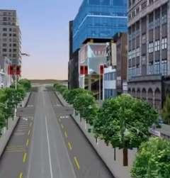
10 What is a Smart City? Smart Buildings inside Smart Cities


11 Rigorous spatial foundation geospatial data are the building blocks of a Smart City. A virtual 3D City Model supports a Creative, Knowledgeable, Sustainable, and Connected Intelligent Virtual EcoCity which allows you to interact with Smart City outputs


 4.")

12 How Do We Get There From Metres To Millimetres 1. Satellites 2. Aircraft 3. UAVs (drones) 4. Vehicles 5. Existing plans 6. Inside buildings 7. Field Survey.

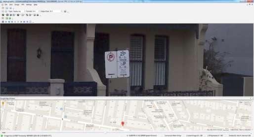
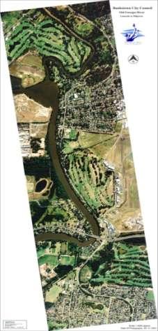
13 Data Acquisition Methods Aerial Survey LiDAR Sensors Terrain and all above ground features including, building, trees, powerlines and other structures Oblique camera sensor Quality nadir for high resolution orthophotos Oblique photos for building modelling and realistic texturing Terrestrial Survey MLS Sensors Detailed road and street scape features 360 degree Cameras Feature extraction & realistic texturing


14 AVIATION PLATFORMS LIDAR AND IMAGERY applying the right platform to every project


15 LIDAR & IMAGERY DIFFERENT PLATFORMS High vehicles preferred Boats Rail Vehicles Tripods Trolleys Quad bikes or even handheld

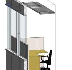
16 LIDAR INSIDE to support Building Information Models (BIMs)

17 LIDAR INSIDE to support Building Information Models (BIMs)


 0.")
18 IMAGERY: VERTICAL Satellite,aerial and UAV photography for land use and accurate terrain definition 0.8m pixel (satellite) 0.25m pixel (camera) 0.06m pixel (camera)

19 IMAGERY: OBLIQUE
20 DATA ACQUISITION Aerial versus Terrestrial Cityscape Capture 1. Aerial Capture provides: 1. Greater access to more building facades 2. Greater efficiency in data capture 3. Definition of rooflines 4. More perspectives on more facades 5. Required perspective for more planning purposes 2. But is limited by: 1. Shadows 2. Building awnings 3. Vegetation 4. Urban canyon.
21 DATA ACQUISITION Aerial versus Terrestrial Cityscape Capture 1. Terrestrial Capture provides: 1. Clearer access to prominent facades 2. Higher resolution 2. But is limited by: 1. Facades accessible by vehicle or on foot 2. Poor building geometry definition (other than streetscape) 3. Building awnings 4. Vegetation 5. Less efficiency in data capture over large areas 6. traffic.

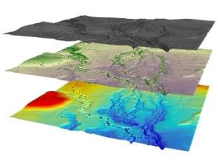
22 3D Modelling Program Aerial Survey is used to generate LOD 0 Accurate Terrain Relief and Digital Surface Model High resolution Orthophoto LOD 1 Building Block Models LOD 2 Building and Bridge Models Waterbodies and Vegetation Models Terrestrial Survey is used to generate LOD 0 Accurate Terrain Relief Model LOD 1 Directional Road Network LOD 1 and LOD 2 Road, Bridge and Tunnel Models LOD 2 City Furniture Models LOD 3 Building Models


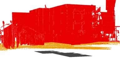
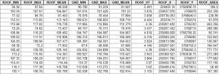
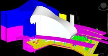
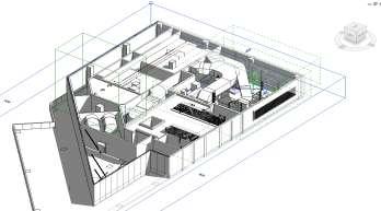
23 Building Models Copyright 2015 AAM Pty Ltd


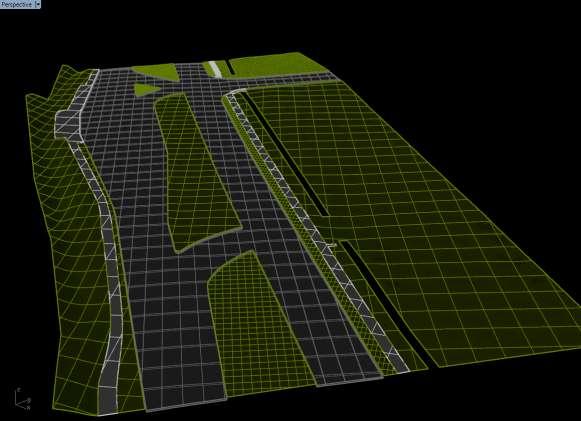
24 Road LOD2 Models Copyright 2015 AAM Pty Ltd
25 Transportation Models Tunnels LOD 1 / LOD2 Closed Solids Ground and Non-Ground Classified Point Cloud Tunnel Closed Solids Copyright 2015 AAM Pty Ltd
26 Transportation Models Bridges LOD 1 / LOD2 Closed Solids Non-Ground Classified Point Cloud Bridges Closed Solid Copyright 2015 AAM Pty Ltd


27 City Furniture Models Copyright 2015 AAM Pty Ltd


28 3D Modelling Program For realism Automatic harvesting of oblique imagery
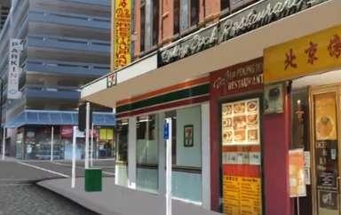
29 Terrestrial Imagery For realism Copyright 2015 AAM Pty Ltd

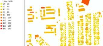
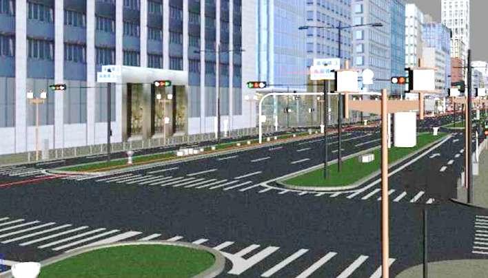
30 Final Derived Models Copyright 2015 AAM Pty Ltd


31 Data Standards International Smart City Mapping Standards and Conventions, CityGML, HTML5, WebGL Futureproof Smart City deployment and provide access to other users functionality

32 3D Spatial Data Infrastructure Hosted or Local Enterprise GIS Visualisation and Analysis Smart City Outputs K2Vi AAM s 3D Visualisation and Analysis Software
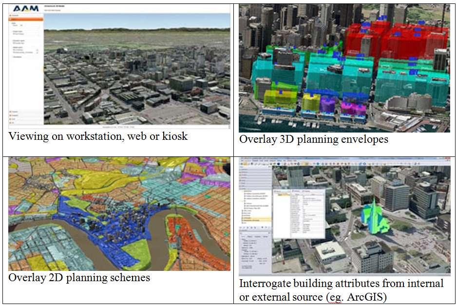
33 Functionality and Benefits
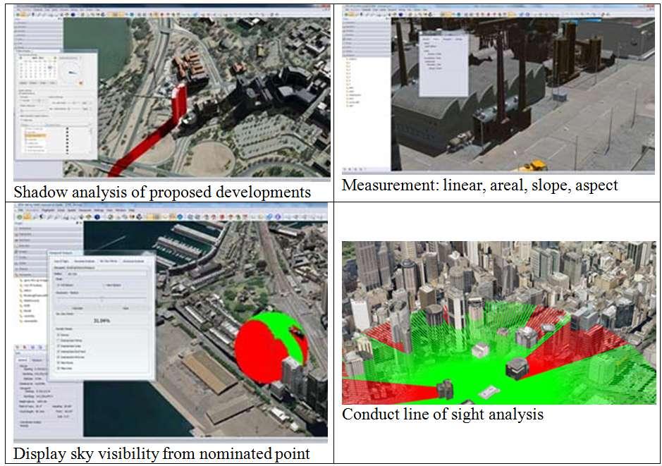
34 Functionality and Benefits

35 Functionality and Benefits Existing Citymodel 35
36 Functionality and Benefits Traffic Flow: Width denotes quantity 36

37 Functionality and Benefits Security Monitoring Coverage: Colour denotes density 37

38 Functionality and Benefits Realtime monitoring of street lighting 38

39 Functionality and Benefits Existing building shapes coloured by energy consumption 39

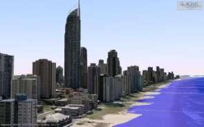
40 Functionality and Benefits Computing and visualising solar visibility on specific sensor 40

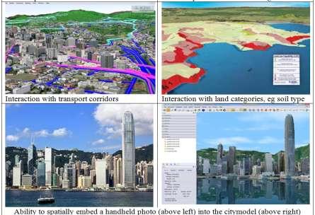
41 Functionality and Benefits Government Authorities - better understand their environment


42 Functionality and Benefits Government Authorities better communication


43 Functionality and Benefits Building Authorities design

44 Benefits Building Authorities promote proposed developments via the web
45 Functionality and Benefits Utilities stormwater and flood management


46 Functionality and Benefits Transport Authorities traffic simulation / real time vehicle animation
47 Functionality and Benefits Improved decision making

48 Thankyou Come and see AAM in the exhibition hall Real World Virtual World Business Development Consultant Michael De Lacy
Geospatial Excellence
 Geospatial Excellence Reality Captured. Certainty Delivered. OUR SERVICES Airborne Survey AAM s diverse range of aerial survey technologies ensures the best tool is deployed to suit the accuracy, timeliness
Mapping a Nation in 3D Singapore s Journey. Bryan Chew Registrar of Titles Assistant Chief Executive Singapore Land Authority
 Mapping a Nation in 3D Singapore s Journey Bryan Chew Registrar of Titles Assistant Chief Executive Singapore Land Authority Singapore Size - 719 sq km Population - 5.5 million Density 7,600/sq km Singapore
GEOMATICS. Shaping our world. A company of
 GEOMATICS Shaping our world A company of OUR EXPERTISE Geomatics Geomatics plays a mayor role in hydropower, land and water resources, urban development, transport & mobility, renewable energy, and infrastructure
Virtual 3D Cities. Chapter VIII. Virtual 3D Cities. 8.1 Introduction. Components. Chapter VIII: Virtual 3D Cities 1
 Chapter VIII Virtual 3D Cities 8.1 Introduction 8.2 CityGML 8.3 Google Earth 8.4 Virtual Earth 8.5 Conclusions Virtual 3D Cities 8.1 Introduction 3D Visualization of cities Languages such as CityGML New
Utilising the Virtual World for Urban Planning and Development
 Utilising the Virtual World for Urban Planning and Development David JONAS, Australia Key words: 3D Visualisations, city models, K2Vi, urban modelling SUMMARY The twenty-first Century has seen the Asia
Geographic information for Strasbourg : from historical land register to 3D GIS city modelling 09/07/2017
 Geographic information for Strasbourg : from historical land register to 3D GIS city modelling 09/07/2017 Table of contents 1. Introduction of Strasbourg 2. A century of land surveying and cadastre 3.
Aerial Survey of Coffee Estates
 Aerial Survey of Coffee Estates Why get an Aerial Survey of your Coffee Estate done? Aerial surveying produces high resolution and highly accurate image data about your coffee estate. This data can be
CITYGML MODELLING FOR SINGAPORE 3D NATIONAL MAPPING
 CITYGML MODELLING FOR SINGAPORE 3D NATIONAL MAPPING K. H. Soon* and V. H. S. Khoo Land Survey Division, Singapore Land Authority, 55 Newton Road, #12-01, 307987 Singapore - (soon_kean_huat, victor_khoo)@sla.gov.sg
Imagery and the Location-enabled Platform in State and Local Government
 Imagery and the Location-enabled Platform in State and Local Government Fred Limp, Director, CAST Jim Farley, Vice President, Leica Geosystems Oracle Spatial Users Group Denver, March 10, 2005 TM TM Discussion
NCTCOG Regional GIS Meeting 6-Years and Going Strong. May 15, 2018 hosted by: Tarrant County
 NCTCOG Regional GIS Meeting 6-Years and Going Strong May 15, 2018 hosted by: Tarrant County Woolpert at a Glance 1911 Founded in Dayton, Ohio 25+ Offices across the nation 800+ Global employees 25+ OFFICES
Features and Benefits
 Autodesk LandXplorer Features and Benefits Use the Autodesk LandXplorer software family to help improve decision making, lower costs, view and share changes, and avoid the expense of creating physical
Unmanned Aerial Systems (UAS) Innovation for affordable, improved and accelerated spatial data acquisition
 Innovation for affordable, improved and accelerated spatial data acquisition") Unmanned Aerial Systems (UAS) Innovation for affordable, improved and accelerated spatial data acquisition Kathrine Kelm, The World Bank Rumyana Tonchovska, FAO Walter Volkmann, Micro Aerial Projects,
Unmanned Aerial Systems (UAS) Innovation for affordable, improved and accelerated spatial data acquisition Kathrine Kelm, The World Bank Rumyana Tonchovska, FAO Walter Volkmann, Micro Aerial Projects,
Cláudio Carneiro dell Ecole Polytechnique Federale de Lausanne
 URBAN UTILITY _ milano 22 03 2013 LA COSTRUZIONE DEL DATO COME PRESUPPOSTO DELLA DECISIONE PRIMA SESSIONE THE USE 3D GIS AND LIDAR DATA FOR URBAN PLANNING AND DECISION MAKING Cláudio Carneiro dell Ecole
ArcGIS Pro 3D Workflows. Zena Pelletier
 ArcGIS Pro 3D Workflows Zena Pelletier 3D as a GIS capability Core part of the platform Desktop Web Device Combine 2D and 3D in the same web GIS architecture Reuse dynamic services across clients Securely
GIS-based Smart Campus System using 3D Modeling
 GIS-based Smart Campus System using 3D Modeling Smita Sengupta GISE Advance Research Lab. IIT Bombay, Powai Mumbai 400 076, India smitas@cse.iitb.ac.in Concept of Smart Campus System Overview of IITB Campus
Trimble s ecognition Product Suite
 Trimble s ecognition Product Suite Dr. Waldemar Krebs October 2010 Trimble Geospatial in the Image Processing Chain Data Acquisition Pre-processing Manual/Pixel-based Object-/contextbased Interpretation
Business Model for sustainable regional development by tourism
 Business Model for sustainable regional development by tourism Why EuroVeloPark Banat? Steps to Success Action proposal 1. Drawing of the Basis Map 2. Data Acquisition, POIs, etc. 3. Printed Map and Distribution
Airborne Corridor-Mapping. Planning and documentation of company infrastructure: precise, rapid, and cost effective
 Airborne Corridor-Mapping Planning and documentation of company infrastructure: precise, rapid, and cost effective Technology Airborne Laser-Scanning, digital orthophotos and thermal imaging: one flight
Emergency Planning. for the. Democratic National. Convention. imaging notes // Spring 2009 //
 Emergency Planning for the Democratic National Convention The DRAPP Demonstrates Partnership among Local, Regional, State, Utility and Federal Governments 14 imaging notes // Spring 2009 // www.imagingnotes.com
Data Conversion to I3S for 3D Modeling from CityGML. Christian Dahmen (con terra GmbH) Satish Sankaran (Esri)
 Satish Sankaran (Esri)") Data Conversion to I3S for 3D Modeling from CityGML Christian Dahmen (con terra GmbH) Satish Sankaran (Esri) 3D Across the ArcGIS Platform Manage Multiscale 3D Models 3D Geodesign ArcGIS for 3D Cities
Data Conversion to I3S for 3D Modeling from CityGML Christian Dahmen (con terra GmbH) Satish Sankaran (Esri) 3D Across the ArcGIS Platform Manage Multiscale 3D Models 3D Geodesign ArcGIS for 3D Cities
Ramani Geosystems. Putting Africa On The Map. Authorized Resellers
 Ramani Geosystems Putting Africa On The Map Authorized Resellers Ramani Profile Started in 1999 Aerial, Land Surveying & Mapping Solutions + 10 Countries in the region + 80 Staff working in projects Asset
Current Research Trends from an Australian Perspective. Dr Philip Collier Research Director
 Current Research Trends from an Australian Perspective Dr Philip Collier Research Director Growth in the spatial sector. 11% pa in the Global Navigation Satellite System market 2010-2020 300% growth in
3D City GIS. Agenda. Why 3D City GIS? What does 3D City GIS mean?
 3D City GIS 1 of 60 WWW.BENTLEY.COM Ben Fredericque, Product Manager, Geospatial Agenda Why 3D City GIS? What does 3D City GIS mean? 2 of 60 WWW.BENTLEY.COM Sydney, Australia, 11 16 April 2010 1 Why 3D
Fugro Geospatial: Turning Spatial Data into Knowledge
 Fugro Geospatial: Turning Spatial Data into Knowledge 2016 Fugro Geospatial, GIS and Consultants Locations Variety of Collection Platforms Traditional Mapping Traditional Mapping Imagery Photogrammetric
Land Administration and Cadastre
 Geomatics play a major role in hydropower, land and water resources and other infrastructure projects. Lahmeyer International s (LI) worldwide projects require a wide range of approaches to the integration
Data Aggregation with InfraWorks and ArcGIS for Visualization, Analysis, and Planning
 Data Aggregation with InfraWorks and ArcGIS for Visualization, Analysis, and Planning Stephen Brockwell President, Brockwell IT Consulting, Inc. Join the conversation #AU2017 KEYWORD Class Summary Silos
Cutting Edge Engineering for Modern Geospatial Systems Rear Admiral Dr. S Kulshrestha, retd
 Cutting Edge Engineering for Modern Geospatial Systems Rear Admiral Dr. S Kulshrestha, retd 11 Jun 2015 GeoIntelligence Asia 2015 The technology would become so pervasive that it becomes a part of you
A Broad View of Geospatial Technology & Systems
 A Broad View of Geospatial Technology & Systems Pete Large Vice President, Trimble On the shoulders of giants 1 Since their time, our ability to generate geospatial information has grown exponentially
Global UAV-based solutions for the industry and agriculture.
 Global UAV-based solutions for the industry and agriculture. Remote sensing of vegetation from drones (UAS). The example of the Trimble Unmanned Aerial Solution Emmanuel de Maistre, co-founder & CEO demaistre@redbird.fr
3D City/Landscape Modeling Non-Building Thematic: Vegetation
 3D City/Landscape Modeling Non-Building Thematic: Vegetation Presenter: Shafarina Wahyu Trisyanti shafarina.wahyu@gmail.com Co-Author: Deni Suwardhi, Agung Budi Harto dsuwardhi@kk-insig.org, agung@gd.itb.ac.id
GIS for 3D Object Generation, Modelling, and Exploitation. Paul Hardy Esri
 GIS for 3D Object Generation, Modelling, and Exploitation Paul Hardy Esri ArcGIS has long understood 3D Multipatch data type in geodatabase - 3D volumetric objects - Collection of triangles, strips, fans,
Bentley Map V8i (SELECTseries 3)
") Bentley Map V8i (SELECTseries 3) A quick overview Why Bentley Map Viewing and editing of geospatial data from file based GIS formats, spatial databases and raster Assembling geospatial/non-geospatial data
Bentley Map V8i (SELECTseries 3) A quick overview Why Bentley Map Viewing and editing of geospatial data from file based GIS formats, spatial databases and raster Assembling geospatial/non-geospatial data
GIS Workshop Data Collection Techniques
 GIS Workshop Data Collection Techniques NOFNEC Conference 2016 Presented by: Matawa First Nations Management Jennifer Duncan and Charlene Wagenaar, Geomatics Technicians, Four Rivers Department QA #: FRG
Sustainable and Harmonised Development for Smart Cities The Role of Geospatial Reference Data. Peter Creuzer
 Sustainable and Harmonised Development for Smart Cities The Role of Geospatial Reference Data Peter Creuzer 1. Introduction - Smart Cities and Geodata 2. Geodata in Germany 3. Examples 4. Data and Service
STEREO ANALYST FOR ERDAS IMAGINE Stereo Feature Collection for the GIS Professional
 STEREO ANALYST FOR ERDAS IMAGINE Stereo Feature Collection for the GIS Professional STEREO ANALYST FOR ERDAS IMAGINE Has Your GIS Gone Flat? Hexagon Geospatial takes three-dimensional geographic imaging
Country Report On Sdi Activities In Singapore ( )
") UNITED NATIONS E/CONF.102/IP.4 ECONOMIC AND SOCIAL COUNCIL Nineteenth United Nations Regional Cartographic Conference for Asia and the Pacific Bangkok, 29 October 1 November 2012 Item 6(b) of the provisional
UNITED NATIONS E/CONF.102/IP.4 ECONOMIC AND SOCIAL COUNCIL Nineteenth United Nations Regional Cartographic Conference for Asia and the Pacific Bangkok, 29 October 1 November 2012 Item 6(b) of the provisional
inovitas be on site with infra3d
 inovitas be on site with infra3d be inspired... Infrastructure has an immense property value and is a prerequisite for a functioning competitive economy. In this context, the modes of transport such as
Geo-Enabling Digital India. 15 th Esri India User Conference GIS and Smart Cities
 15 th Esri India User Conference 2014 GIS and Smart Cities 15 th Esri India User Conference 2014 GIS and Smart Cities Agendra Kumar President, Esri India Our World Is Facing Serious Challenges Our World
<Insert Picture Here> Oracle Spatial 11g. Dr. Siva Ravada
 Oracle Spatial 11g Dr. Siva Ravada New in Oracle Spatial 11g 3D Support Spatial Web Services Network Data Model GeoRaster Performance Improvements 3D Applications Location-based services
Themes for Geomatics Conference. Geodesy Themes
 Themes for Geomatics Conference Geodesy Themes Geodynamics o Modeling the Deformation of the Earth s Crust o Recent Advances in Geometric Approaches to Deformation Analysis o Monitoring Systems (Sensors
BIM and INSPIRE, for a better integration of built infrastructures in their environment : the MINnD project
 BIM and INSPIRE, for a better integration of built infrastructures in their environment : the MINnD project François ROBIDA Christophe CASTAING Strasbourg, > 1 8 septembre 2017 ABOUT BIM Building Information
Exploit your geodata to enable smart cities and countries
 Exploit your geodata to enable smart cities and countries Carsten Rönsdorf, Head of Advisory Services Middle East Practice Manager Future Cities, standards and 3D 24 November 2014 Importance of Standards
Aerial Photography and Imagery Resources Guide
 Aerial Photography and Imagery Resources Guide Cheyenne and Laramie County Cooperative GIS Created and Maintained by the GIS Coordinator for the Cooperative GIS Program March 2011 CHEYENNE / LARAMIE COUNTY
Eyes in the Sky & Data Analysis.
 Eyes in the Sky & Data Analysis How can we collect Information about Earth Climbing up Trees & Mountains Gathering Food Self Protection Understanding Surroundings By Travelling Collected Information Converted
Aerial Photography and Imagery Resources Guide
 Aerial Photography and Imagery Resources Guide Cheyenne and Laramie County Cooperative GIS Created and Maintained by the GIS Coordinator for the Cooperative GIS Program May 2016 CHEYENNE / LARAMIE COUNTY
Lesson 4b Remote Sensing and geospatial analysis to integrate observations over larger scales
 Lesson 4b Remote Sensing and geospatial analysis to integrate observations over larger scales We have discussed static sensors, human-based (participatory) sensing, and mobile sensing Remote sensing: Satellite
Topographic Strategy National Topographic Office March 2015
 www.linz.govt.nz Topographic Strategy National Topographic Office March 2015 >> Foreword Topographic information is vital to understanding our country and its assets, and for supporting economic development.
SOLUTIONS ADVANCED GIS. TekMindz are developing innovative solutions that integrate geographic information with niche business applications.
 ADVANCED GIS SOLUTIONS TekMindz are developing innovative solutions that integrate geographic information with niche business applications. TEK INDZ TM GIS Services Overview At the leading edge of geospatial
INSPIRE in the context of EC Directive 2002/49/EC on Environmental Noise
 INSPIRE in the context of EC Directive 2002/49/EC on Environmental Noise Simon Shilton Acustica Ltd, United Kingdom Nigel Jones Extrium Ltd, United Kingdom About the Authors www.acustica.co.uk Acoustics
European Spatial Data Research. EuroSDR. Prof. Dr. Ir. Joep Crompvoets. General Assembly CLGE Tirana 18 March
 EuroSDR Prof. Dr. Ir. Joep Crompvoets General Assembly CLGE - 2016 Tirana 18 March 2016 INTRODUCTORY QUESTIONS Who knows what is EuroSDR? Who does NOT know what is EuroSDR? Who is employed at mapping agencies?
Auckland Transport. Auckland Council. Statement of Evidence of Simon John Ferneyhough
 Under the Resource Management Act 1991 In the matter of Notices of Requirement to enable the construction, operation and maintenance of the City Rail Link Between Auckland Transport Requiring Authority
May 2011 Oracle Spatial User Conference
 May 2011 Oracle Spatial User Conference Oracle Spatial User Conference! May 19, 2011 Ronald Reagan Building and International Trade Center Washington, DC USA May 2011 Oracle Spatial User Conference Francois
Techniques for Science Teachers: Using GIS in Science Classrooms.
 Techniques for Science Teachers: Using GIS in Science Classrooms. After ESRI, 2008 GIS A Geographic Information System A collection of computer hardware, software, and geographic data used together for
Sova3D - Pilot Case: Hyvinkää Architectural Competition. Internet of Spaces
 Sova3D - Pilot Case: Hyvinkää Architectural Competition SOVA3D SOVA3D offers Internet Based Services for Building Environment 3D Digitalisation. - 3D-VIRTUALMODELS - City Model - Geometry Models - BIM
GENERATION OF 3D CITY MODELS FROM TERRESTRIAL LASER SCANNING AND AERIAL PHOTOGRAPHY: A CASE STUDY
 GENERATION OF 3D CITY MODELS FROM TERRESTRIAL LASER SCANNING AND AERIAL PHOTOGRAPHY: A CASE STUDY Hakan KARABORK 1, Fatih SARI 1 1 Selcuk University in Konya, Faculty of Engineering and Architecture Konya,
An Industry Perspective. Bryn Fosburgh Vice President Trimble
 An Industry Perspective Bryn Fosburgh Vice President Trimble Who are we? Professionals & Consultants Geospatial Professionals working at or with: AEC Consultants Transportation Departments Construction
Spanish national plan for land observation: new collaborative production system in Europe
 ADVANCE UNEDITED VERSION UNITED NATIONS E/CONF.103/5/Add.1 Economic and Social Affairs 9 July 2013 Tenth United Nations Regional Cartographic Conference for the Americas New York, 19-23, August 2013 Item
Spatial Data Science. Soumya K Ghosh
 Workshop on Data Science and Machine Learning (DSML 17) ISI Kolkata, March 28-31, 2017 Spatial Data Science Soumya K Ghosh Professor Department of Computer Science and Engineering Indian Institute of Technology,
US National Spatial Data Infrastructure A Spatial Framework for Governance and Policy Development to Enable a Location-Based Digital Ecosystem
 GeoPlatform Workshop 7 Dec 2016, Department of the Interior Washington, D.C. US National Spatial Infrastructure A Spatial Framework for Governance and Policy Development to Enable a Location-Based Digital
Country Report on SDI Activities in Singapore *
 UNITED NATIONS E/CONF.100/CRP.9 ECONOMIC AND SOCIAL COUNCIL Eighteenth United Nations Regional Cartographic Conference for Asia and the Pacific Bangkok, 26-29 October 2009 Item 7(a) of the provisional
Papua New Guinea LiDAR Factsheet. Pacific-Australia Climate Change Science and Adaptation Planning. Vanimo. Bismark Sea. Wewak
 Pacific-Australia Climate Change Science and Adaptation Planning INDONESIA Vanimo Ninigo Group Wewak Madang Mount Hagen Kundiawa Goroka Mendi Daru AUSTRALIA Kerema Gulf of Papua Admiralty Islands Mussau
COMPANY PROFILE. For PHOTOGRAMMETRY, LiDAR, BIM, UAV, GIS and SURVEYING SOLUTIONS. Submitted by MARVEL GEOSPATIAL SOLUTIONS PVT.LTD.
 COMPANY PROFILE For PHOTOGRAMMETRY, LiDAR, BIM, UAV, GIS and SURVEYING SOLUTIONS Submitted by MARVEL GEOSPATIAL SOLUTIONS PVT.LTD. Table of Contents 1. ABOUT US... 3 1.1 MISSION/VISION... 4 2. SERVICES
Smart Cities: Visualization
 Smart Cities: Visualization ISO/IEC JTC 1/SC24 Meetings 20-25 January 2019 Seoul, Korea Peter Ryan 1 and Myeong Won Lee 2 1 Defence Science & Technology Group, Australia 2 University of Suwon, Korea Presentation
SPURRING NATION S ECONOMY THROUGH SmartKADASTER
 SPURRING NATION S ECONOMY THROUGH SmartKADASTER SR MOHAMAD KAMALI BIN ADIMIN DIVISION DIRECTOR (CADASTRE) DEPARTMENT OF SURVEY AND MAPPING MALAYSIA THE NEED TO TRANSFORM TRANSFORMATION AGENDA EMPOWERING
GIS = Geographic Information Systems;
 What is GIS GIS = Geographic Information Systems; What Information are we talking about? Information about anything that has a place (e.g. locations of features, address of people) on Earth s surface,
REVIEW MAPWORK EXAM QUESTIONS 31 JULY 2014
 REVIEW MAPWORK EXAM QUESTIONS 31 JULY 2014 Lesson Description In this lesson we: Focus on key concepts and exam questions relating to GIS. Question 1 Test Yourself The most important component of a GIS
Japan Construction Information Center
 Japan Construction Information Center A Framework for Data Coordination Method of Maintenance Data and 3D Conceptual Model on CIM Based Database July 2016 Japan Construction Information Center Foundation
Building a National Data Repository
 Building a National Data Repository Mladen Stojic, Vice President - Geospatial 1/30/2013 2012 Intergraph Corporation 1 Information has meaning and gives power only when shared and distributed. Information,
Conference at a Glance
 Conference at a Glance 8:30 AM MONDAY ROOM 333 ROOM 327/328 ROOM 238 ROOM 296/298 WELCOME and KEYNOTE SPEAKER MICHAEL MILASKA 10 AM BREAK 10:30 AM Web Applications I 12 PM 1:30 PM Intro to R Data Science
CENSUS MAPPING WITH GIS IN NAMIBIA. BY Mrs. Ottilie Mwazi Central Bureau of Statistics Tel: October 2007
 CENSUS MAPPING WITH GIS IN NAMIBIA BY Mrs. Ottilie Mwazi Central Bureau of Statistics E-mail: omwazi@npc.gov.na Tel: + 264 61 283 4060 October 2007 Content of Presentation HISTORICAL BACKGROUND OF CENSUS
Spatial Analysis in Decision Making: A European Perspective. Andrew Coote TASSIC Forum Wednesday 24 th October 2018
 Spatial Analysis in Decision Making: A European Perspective Andrew Coote TASSIC Forum Wednesday 24 th October 2018 1 Agenda Set Context Examples of Real Impacts Thoughts on Future Challenges 2 Hype Blockchain
Industry Trends and Direction: a quick look! John Whitehead Trimble Navigation Ltd.
 Industry Trends and Direction: a quick look! John Whitehead Trimble Navigation Ltd. Converging forces have placed geospatial information at the center of an evolving ecosystem Technology Societal Forces
THE USE OF GEOMATICS IN CULTURAL HERITAGE AND ARCHAEOLOGY FOR VARIOUS PURPOSES
 THE USE OF GEOMATICS IN CULTURAL HERITAGE AND ARCHAEOLOGY FOR VARIOUS PURPOSES FEBRUARY 2013 AL BEIDA GEOPLAN CONTENT Company Profile Concept Objectives and Strategies Data Production Methods Data Samples
Yrd. Doç. Dr. Saygın ABDİKAN Öğretim Yılı Güz Dönemi
 Yabancı Dil III (YDL285) Introduction to Geomatics Yrd. Doç. Dr. Saygın ABDİKAN 2017-2018 Öğretim Yılı Güz Dönemi 1 géomatique Geo (Earth) + informatics Geodesy + Geoinformatics Geomatics: The mathematics
EO Information Services. Assessing Vulnerability in the metropolitan area of Rio de Janeiro (Floods & Landslides) Project
 Project") EO Information Services in support of Assessing Vulnerability in the metropolitan area of Rio de Janeiro (Floods & Landslides) Project Ricardo Armas, Critical Software SA Haris Kontoes, ISARS NOA World
EO Information Services in support of Assessing Vulnerability in the metropolitan area of Rio de Janeiro (Floods & Landslides) Project Ricardo Armas, Critical Software SA Haris Kontoes, ISARS NOA World
Potential and Accuracy of Digital Landscape Analysis based on high resolution remote sensing data
 'Spatial Information for Sustainable Management of Urban Areas' Mainz, 2-4 February 2009, Germany Potential and Accuracy of Digital Landscape Analysis based on high resolution remote sensing data Dr. Matthias
H E L S I N K I 3D+ City Models and Smart Projects. Project Manager/ Architect/MSc (Civ.Eng) Jarmo Suomisto
 Jarmo Suomisto") H E L S I N K I 3D+ 3D City Models and Smart Projects Project Manager/ Architect/MSc (Civ.Eng) Jarmo Suomisto Project Manager/ MSc (Civ.Eng) Kari Kaisla Coordinator/ MSc (Civ.Eng) Enni Airaksinen Project
H E L S I N K I 3D+ 3D City Models and Smart Projects Project Manager/ Architect/MSc (Civ.Eng) Jarmo Suomisto Project Manager/ MSc (Civ.Eng) Kari Kaisla Coordinator/ MSc (Civ.Eng) Enni Airaksinen Project
Horizon Scanning and Research Lead Innovation
 Horizon Scanning and Research Lead Innovation Helsinki, Finland 25 January 2013 Future Challenges,, Future Cooperation Joep 1 Crompvoets eurosdr@soc.kuleuven.be Objectives 1. EuroSDR 2. Horizon Scanning
Preparation of Database for Urban Development
 Preparation of Database for Urban Development By PunyaP OLI, 1. Chairman, ERMC (P) Ltd., Kathmandu, Nepal. Email: punyaoli@ermcnepal.com 2. Coordinator, Himalayan College of Geomatic Engineering and Land
June 19 Huntsville, Alabama 1
 June 19 Huntsville, Alabama 1 Real-Time Geospatial Data: The Fusion of PI and ArcGIS Enabling Smarter Facilities Management OSIsoft and Esri Mapping and Location Analytics Platform Supporting Your Use
SLOPE HAZARD AND RISK MAPPING: A TECHNOLOGICAL PERSPECTIVE
 International Symposium on Multi-Hazard and Risk 2015 23-24 March 2015, UTM Kuala Lumpur SLOPE HAZARD AND RISK MAPPING: A TECHNOLOGICAL PERSPECTIVE Very high resolution DTM derived from LiDAR LiDAR Ortho
CLICK HERE TO KNOW MORE
 CLICK HERE TO KNOW MORE GeoSpace for Singapore s Whole-of-Government Data Sharing Asia GeoSpatial Forum 17 19 Oct 2011 Lee Kim Haw Singapore Land Authority Introducing Singapore Land Authority Limited
Introduction of PASCO Corporation
 Technical Seminar Reference Frame in Practice, Introduction of PASCO Corporation MASAKI MIYASAKA Sponsors: Page 1 Company Profile Establishment: October 27, 1953 Head office: Meguro-ku, Tokyo (57 offices
Esri and GIS Education
 Esri and GIS Education Organizations Esri Users 1,200 National Government Agencies 11,500 States & Regional Agencies 30,800 Cities & Local Governments 32,000 Businesses 8,500 Utilities 12,600 NGOs 11,000
2 nd Japan and Republic of Korea LiDAR Survey Symposium
 2 nd Japan and Republic of Korea LiDAR Survey Symposium 2010 年 9 月 20 日 Prof. Woosug Cho wcho@inha.ac.kr Spacematics Lab Department of Civil Engineering Inha University Presentation on Current Status in
BIM and Geomatics / GIS Integration Malaysian and Turkish Perspectives
 BIM and Geomatics / GIS Integration Malaysian and Turkish Perspectives Alias Abdul Rahman (UTM), Umit Isikdag (MSGSU), Sedat Bakici (TKGM) and Kherun Nita Ali (UTM) Contents Introduction Malaysian perspectives
Corporate. Information. Railway Infrastructure Administrator. Year indracompany.com
 geospatial and mobility Corporate Geographic Information System of ADIF Railway Infrastructure Administrator. Year 2009-2010 Corporate Geographic Information System of ADIF ADIF. Spanish Administrator
EuroSDR (European Spatial Data Research)
") EuroSDR (European Spatial Data Research) ROLLING RESEARCH PLAN 2015-2018 EuroSDR Secretariat Public Governance Institute KU Leuven Parkstraat 45 bus 3609 3000 Leuven Belgium Tel.: +32 16 32 31 80 Fax:
EuroSDR (European Spatial Data Research) ROLLING RESEARCH PLAN 2015-2018 EuroSDR Secretariat Public Governance Institute KU Leuven Parkstraat 45 bus 3609 3000 Leuven Belgium Tel.: +32 16 32 31 80 Fax:
Land Cover Classification Mapping & its uses for Planning
 Land Cover Classification Mapping & its uses for Planning What is Land Cover Classification Mapping? Examples of an actual product Why use Land Cover Classification Mapping for planning? Possible uses
USING GIS CARTOGRAPHIC MODELING TO ANALYSIS SPATIAL DISTRIBUTION OF LANDSLIDE SENSITIVE AREAS IN YANGMINGSHAN NATIONAL PARK, TAIWAN
 CO-145 USING GIS CARTOGRAPHIC MODELING TO ANALYSIS SPATIAL DISTRIBUTION OF LANDSLIDE SENSITIVE AREAS IN YANGMINGSHAN NATIONAL PARK, TAIWAN DING Y.C. Chinese Culture University., TAIPEI, TAIWAN, PROVINCE
Leveraging Geospatial Technology for Cadastral Surveys
 Matthew Delano, LS Geospatial World Forum January 2017 Leveraging Geospatial Technology for Cadastral Surveys Fit-for-Purpose Simple to start Can improve over time whenever necessary Meet the needs of
QuestUAV British UAV Manufacturer
 QuestUAV British UAV Manufacturer Aircraft designed to carry sensors such as high resolution cameras infra red cameras thermal and video cameras multiple payloads QuestUAV have been operating for five
Utilization and Provision of Geographical Name Information on the Basic Map of Japan*
 UNITED NATIONS WORKING PAPER GROUP OF EXPERTS NO. 1/9 ON GEOGRAPHICAL NAMES Twenty-eight session 28 April 2 May 2014 Item 9 of the Provisional Agenda Activities relating to the Working Group on Toponymic
New Methods for GeoDesign with ArcGIS and CityEngine. Dr. Özgür Ertac, Prof. Dr. Jörg Schaller, Cristina Mattos Tech. Uni. Munich, Esri Germany
 New Methods for GeoDesign with ArcGIS and CityEngine Dr. Özgür Ertac, Prof. Dr. Jörg Schaller, Cristina Mattos Tech. Uni. Munich, Esri Germany Agenda Evolution in 3D Introduction 3D Across the ArcGIS Platform
Flood Mapping Michael Durnin October 9 th
 Michael Durnin October 9 th 2014 Leading Surveyors Company Profile Est. 1983 Celebrating 30 Years in Business Six Offices in UK & Ireland Over 30 Specialised Survey Services ISO 9001:2008 Registered Over
State of Israel Ministry of Housing and Construction Survey of Israel. The Hydrological project case
 State of Israel Ministry of Housing and Construction Survey of Israel The Hydrological project case Survey of Israel Content Introduction To the Survey of Israel The operation assumptions The main responsibilities
IDBE. Common conceptual framework and roadmap of collaboration in Spatial Standards for the Digital Built Environment
 IDBE Common conceptual framework and roadmap of collaboration in Spatial Standards for the Digital Built Environment GeoBIM: 3D GIS in China Mei Xue: In my opinion, what matters most in the integration
Investigating the practical relationship between GIS and BIM; then relating that to a 3D cadastre. J. Gabriel van Wyk, Johan Nel
 Investigating the practical relationship between GIS and BIM; then relating that to a 3D cadastre. J. Gabriel van Wyk, Johan Nel Overview So exactly what is BIM? Available BIM offerings in the market Traditional
Case Study microdrones in Geomatics Remote Sensing
 Case Study microdrones in Geomatics Remote Sensing Version 1.0 Presented by: Carlos Espadas (INGECOR Geomática SL) & Michael Thoss (microdrones GmbH) Profiles: microdrones / Ingecor Geomática Contact information
Pushing the Standards Edge: Collaborative Testbeds to Accelerate Standards Development and Implementation
 Pushing the Standards Edge: Collaborative Testbeds to Accelerate Standards Development and Implementation Mark E. Reichardt President mreichardt@opengeospatial.org 31 October 2006 2006 Open Geospatial