Eyes in the Sky & Data Analysis.
|
|
|
- Carol Terry
- 5 years ago
- Views:
Transcription

1 Eyes in the Sky & Data Analysis
2 How can we collect Information about Earth
3 Climbing up Trees & Mountains Gathering Food Self Protection Understanding Surroundings


4 By Travelling Collected Information Converted into maps

5 By Scientific Methods Cameras Aircrafts Sensors Satellites
6 Activity 1 (Group) Compare the Advantages & Disadvantages of 1. Traditional Methods 2. Scientific Methods for Collecting Information about Earth
7 Activity 1 - Consolidation Disadvantages of Traditional Methods for collecting information about Earth Information Gathering is not Possible If Climate is not Favorable If Places are not Reachable It takes more Time to Collect Recent changes may not be Recorded
8 Advantages of using Scientific Methods for collecting information about Earth Vast area can be Analysed Permanent Information is Obtained Same Information can be used for different Subjects Quick Data Collection & Analysis Updating Recent Changes is Easy Even Minute things can be Analysed


9 19 th Cent. The Invention of Photography
10 Used the Possibility of Photography for Remote Sensing Mounting cameras on Hand Pigeons Balloons Aircrafts

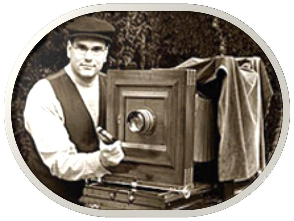
11 Camera on Hand Discuss the Advantages & Disadvantages o o o o o o


12 For what Purpose did it use?

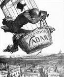
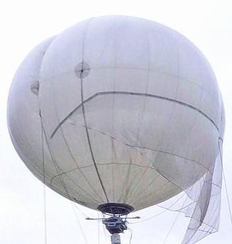
13 Camera on Balloons

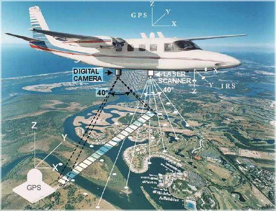
14 Camera on Aircraft o o Discuss the uses

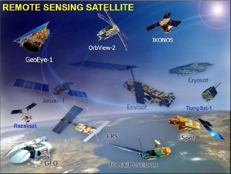
15 Possibility of Satellites for Remote Sensing Began in 1960s Used Cameras & Scanners


16 Collecting Information about an Object With the help of Satellite Without actual Physical Contact
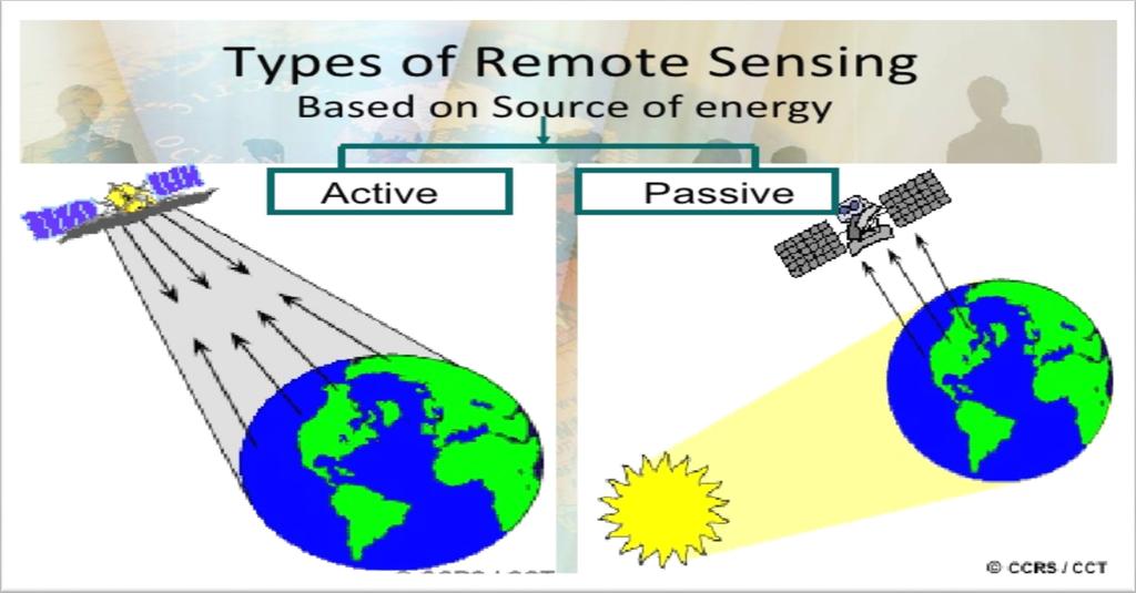
17 Source of Energy Remote Sensing Factors Platform Sensor
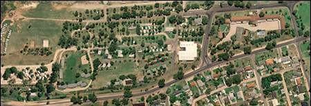
18 Based on Source of Energy Remote Sensing can be Active Remote Sensing Passive Remote Sensing Artificial Source of Energy Solar Energy
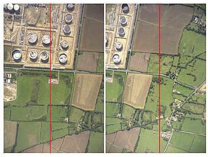
19

20 Sensors Instrument used for Data Scanners Collection through Cameras Remote Sensing

21 Try to locate the position of the camera when it captured each of these photographs.
22 Based on Platform Remote Sensing can be Terrestrial Photography Aerial Remote Sensing Satellite Remote Sensing


23 Terrestrial Photography From Earth s Surface With Cameras

24 Aerial Remote Sensing

25 Observe the Picture and Write your Findings
26 Observation Aerial Photograph Repeated Portion Ensured Continuity To obtain 3D Vision Overlap Find out These Stereo Pair Stereoscope

27 Stereo Pair Stereoscope
28
29 Activity 2 Discuss the Advantages & Disadvantages of Aerial Remote Sensing
30 Limitations of Aerial Remote Sensing Shaking of Aircraft Open Space for Landing & Takeoff Not for Large Area Cost for Refueling

31 Satellite Remote Sensing

32 Artificial satellites can be classified into 2 based on the Orbit Orbit
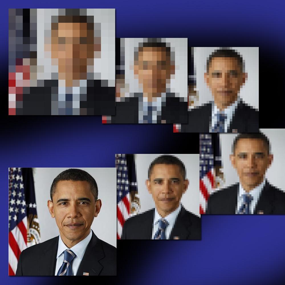
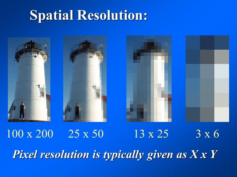
33

34 Geostationary Satellites About km. above Earth 1/3 of Earth comes Under its View Move with the Earth s Rotation Stays on a Specific Place Continuous Data Collection on it Used for Telecommunication, Weather..

35 Sun Synchronous Satellites About 1000 km. below Field of View is Less Move the Earth along the Poles Repetitive Data Collection is Possible Used for Data Collection on Natural Resources, Land use, Ground Water...
36 Activity 3 (Complete the Table) Geostationary Sun Synchronous Orbit Length Field of View Movement Data Collection Uses Other Examples
37 Geostationary Sun Synchronous Orbit Length km 1000 km Field of View More Less Movement Earth s Rotation Polar Data Collection Continuous Repetitive Uses Other Communication, Weather.. Stays on a specific Place on Earth Natural Resources, Land use, Water.. Used for Remote Sensing Examples INSAT 2A, 2B, 2C IRS ID, IC & ID


38 India IRS France SPOT Japan MOS European Space Agency ERS
39
40 Spectral Signature Features of Sensor Satellite Imagery Spatial Resolution Amount of Reflected Energy by each Object Objects Recognized by the Sensor are converted into Images with the help of Computers Size of the smallest Object on Earth that can be Recognized by the Sensor
41

42 Remote Sensing can be used for
43 Ocean exploration Weather observation
44 Land use Flood and Drought
45 Forest Agriculture

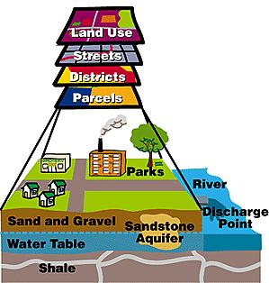
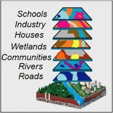
46 Oil explorations Ground Water
47 Activity 4 List the Uses of Remote Sensing Technology
48 Weather observations Ocean explorations Understanding land use Monitoring flood and drought Identifying forest fires Know the extent of crops & spread of pest attack Oil explorations Locate ground water potential
49 Information Hardware GIS Software User
50
51 Two kinds of Data are necessary for data analysis in GIS Spatial Data Attributes Latitudinal & Longitudinal Positions of an Objects on Earth Elements of Locations Eg. Platform, Depth, Water (Fresh/Not), Ownership of a Well
52 Can we integrate all these Different Maps? What will be the Advantages? How is it Possible?
53 Layers

54 Different Layers in the Map of India
55 Analytical Capabilities of GIS Network Analysis Overlay Analysis Buffer Analysis

56 What are the Advantages Finding the Shortest Route For Emergency

57 Buffer Analysis

58 Overlay Analysis
59 Applications of Buffer Analysis For Widening Road Buffer Zone for Schools Hospitals Airport Applications of Overlay Analysis For Comparing the Changes Eg. Crops in an area between Landuse
60 Activity 5 (Group Discussion) Different Applications of GIS Collecting Information on Places, Land type, Land use, Parched land, Forest, Soil, Road.. Developmental Activities Better Land use Environmental Activities
61 Uses of GIS o Compile Data o Update the Data o Thematic Studies o Spatial Representation o Visual Model Generation o Prepare Maps, Tables & Graphs
62 Activity 6 by using Qgis Software 1. Finding shortest way 2. Preparing a Buffer zone

63 Does your Mobile has this Facility? What are its Uses? What is it?
64 Helps sensing the Latitudinal & Longitudinal Location and Elevation of Objects on Earth with time GPS
65 GPS Series of 24 Satellites Placed at 6 different Orbits Requires Signals from at least 4 Satellites Can locate places with the help of signals from Satellites

66
67
68 Activity 7 Discuss the Uses of GPS based on the Following 1. Transportation Road, Water, Air.. 2. Security Valuable things VIPs 3. Survey, Map Preparation 4. Communication 5.
69 Additional Activities 1. Remote Sensing can be divided based on Energy & Platform. Which are they? 2. What do you think are the advantages of Satellite remote Sensing when compare with Aerial Remote Sensing? 3. Make a comparison between Geostationary & Sun Synchronous Satellites. 4. Two kinds of data are necessary for data Analysis in GIS. Which are they? 5. What are the uses of GIS?


70 Michael Angelo M.A. MA (Phi., His.) HSA (Social Science) Master Trainer, EKM
REVIEW MAPWORK EXAM QUESTIONS 31 JULY 2014
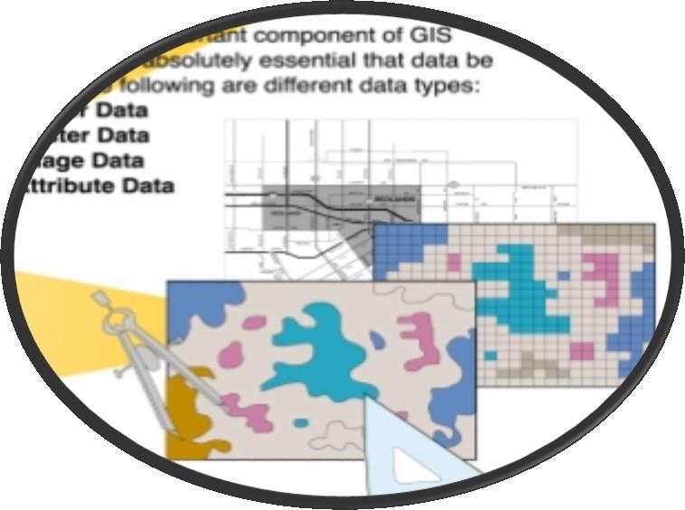
 REVIEW MAPWORK EXAM QUESTIONS 31 JULY 2014 Lesson Description In this lesson we: Focus on key concepts and exam questions relating to GIS. Question 1 Test Yourself The most important component of a GIS
Terrain Analysis through Maps.
 Terrain Analysis through Maps Need for Maps Theodolite Every Inch on Earth is Measured Maps are Prepared based on these Measurements Classification of Maps Function Scale Physical (Natural Features)
(Refer Slide Time: 3:48)
") Introduction to Remote Sensing Dr. Arun K Saraf Department of Earth Sciences Indian Institute of Technology Roorkee Lecture 01 What is Satellite based Remote Sensing Hello, hello everyone this is Arun
Introduction to Remote Sensing Dr. Arun K Saraf Department of Earth Sciences Indian Institute of Technology Roorkee Lecture 01 What is Satellite based Remote Sensing Hello, hello everyone this is Arun
Unit 1, Lesson 3 What Tools and Technologies Do Geographers Use?
 Unit 1, Lesson 3 What Tools and Technologies Do Geographers Use? Geographers use a variety of tools and technologies in investigating geographic questions. Maps and globes both represent the earth, but
Unit 1, Lesson 2. What is geographic inquiry?
 What is geographic inquiry? Unit 1, Lesson 2 Understanding the way in which social scientists investigate problems will help you conduct your own investigations about problems or issues facing your community
PRINCIPLES OF REMOTE SENSING. Electromagnetic Energy and Spectral Signatures
 PRINCIPLES OF REMOTE SENSING Electromagnetic Energy and Spectral Signatures Remote sensing is the science and art of acquiring and analyzing information about objects or phenomena from a distance. As humans,
GIS and Remote Sensing
 Spring School Land use and the vulnerability of socio-ecosystems to climate change: remote sensing and modelling techniques GIS and Remote Sensing Katerina Tzavella Project Researcher PhD candidate Technology
Yrd. Doç. Dr. Saygın ABDİKAN Öğretim Yılı Güz Dönemi
 Yabancı Dil III (YDL285) Introduction to Geomatics Yrd. Doç. Dr. Saygın ABDİKAN 2017-2018 Öğretim Yılı Güz Dönemi 1 géomatique Geo (Earth) + informatics Geodesy + Geoinformatics Geomatics: The mathematics
SHRI ANGALAMMAN COLLEGE OF ENGINEERING AND TECHNOLOGY (An ISO 9001:2008 Certified Institution) Siruganoor, Tiruchirappalli
 Siruganoor, Tiruchirappalli") SHRI ANGALAMMAN COLLEGE OF ENGINEERING AND TECHNOLOGY (An ISO 9001:2008 Certified Institution) Siruganoor, Tiruchirappalli 621 105. FS 81504 DEPARTMENT OF CIVIL ENGINEERING 1. Define remote sensing. CE-1304
SHRI ANGALAMMAN COLLEGE OF ENGINEERING AND TECHNOLOGY (An ISO 9001:2008 Certified Institution) Siruganoor, Tiruchirappalli 621 105. FS 81504 DEPARTMENT OF CIVIL ENGINEERING 1. Define remote sensing. CE-1304
History & Scope of Remote Sensing FOUNDATIONS
 History & Scope of Remote Sensing FOUNDATIONS Lecture Overview Introduction Overview of visual information Power of imagery Definition What is remote sensing? Definition standard for class History of Remote
GIS = Geographic Information Systems;
 What is GIS GIS = Geographic Information Systems; What Information are we talking about? Information about anything that has a place (e.g. locations of features, address of people) on Earth s surface,
Unit 1 The Basics of Geography. Chapter 1 The Five Themes of Geography Page 5
 Unit 1 The Basics of Geography Chapter 1 The Five Themes of Geography Page 5 Geography comes from the Greek word geographia, which means to describe the earth. Geography is the study of the distribution
Imagery and the Location-enabled Platform in State and Local Government
 Imagery and the Location-enabled Platform in State and Local Government Fred Limp, Director, CAST Jim Farley, Vice President, Leica Geosystems Oracle Spatial Users Group Denver, March 10, 2005 TM TM Discussion
SURVEYING Chapter 1 Introduction
 PHILADELPHIA UNIVERSITY Faculty of Engineering. Department of Civil Engineering. SURVEYING Chapter 1 Introduction Surveying : the art or science of measuring and representing natural and artificial features
GEOMATICS. Shaping our world. A company of
 GEOMATICS Shaping our world A company of OUR EXPERTISE Geomatics Geomatics plays a mayor role in hydropower, land and water resources, urban development, transport & mobility, renewable energy, and infrastructure
Test Bank Chapter 2: Representations of Earth
 Multiple Choice Test Bank Chapter 2: Representations of Earth 1. A rhumb line on a Mercator projection is a line of. a. true size b. true shape c. true compass bearing d. true location 2. Maximum longitude
Remote Sensing in Meteorology: Satellites and Radar. AT 351 Lab 10 April 2, Remote Sensing
 Remote Sensing in Meteorology: Satellites and Radar AT 351 Lab 10 April 2, 2008 Remote Sensing Remote sensing is gathering information about something without being in physical contact with it typically
GIS (GEOGRAPHIC INFORMATION SYSTEMS)
") GIS (GEOGRAPHIC INFORMATION SYSTEMS) 1 1. DEFINITION SYSTEM Any organised assembly of resources and procedures united and regulated by interaction or interdependence to complete a set of specific functions.
GIS (GEOGRAPHIC INFORMATION SYSTEMS) 1 1. DEFINITION SYSTEM Any organised assembly of resources and procedures united and regulated by interaction or interdependence to complete a set of specific functions.
Lesson 4b Remote Sensing and geospatial analysis to integrate observations over larger scales
 Lesson 4b Remote Sensing and geospatial analysis to integrate observations over larger scales We have discussed static sensors, human-based (participatory) sensing, and mobile sensing Remote sensing: Satellite
Chapter 1 Overview of Maps
 Chapter 1 Overview of Maps In this chapter you will learn about: Key points when working with maps General types of maps Incident specific maps Map legend and symbols Map sources A map is a navigational
Applications of GIS in Electrical Power System
 Applications of GIS in Electrical Power System Abdulrahman M. AL-Sakkaf 201102310 CRP 514 May 2013 Dr. Baqer M. AL-Ramadan Abstract GIS has been widely used in various areas and disciplines. This paper
Identifying Audit, Evidence Methodology and Audit Design Matrix (ADM)
") 11 Identifying Audit, Evidence Methodology and Audit Design Matrix (ADM) 27/10/2012 Exercise XXX 2 LEARNING OBJECTIVES At the end of this session participants will be able to: 1. Identify types and sources
11 Identifying Audit, Evidence Methodology and Audit Design Matrix (ADM) 27/10/2012 Exercise XXX 2 LEARNING OBJECTIVES At the end of this session participants will be able to: 1. Identify types and sources
Mapping Earth s Surface Chapter 2 Section 3
 Mapping Earth s Surface Chapter 2 Section 3 Day 1 Objective I will understand maps can be used to find locations on Earth and to represent information about features on Earth s Surface I will understand
Introduction to GIS. Dr. M.S. Ganesh Prasad
 Introduction to GIS Dr. M.S. Ganesh Prasad Department of Civil Engineering The National Institute of Engineering, MYSORE ganeshprasad.nie@gmail.com 9449153758 Geographic Information System (GIS) Information
Geospatial Technologies
 An Overview of Prepared by: John McGee Jennifer McKee With support from: NSF DUE-0903270 in partnership with: Geospatial Technician Education Through Virginia s Community Colleges (GTEVCC) What is Geospatial?
- satellite orbits. Further Reading: Chapter 04 of the text book. Outline. - satellite sensor measurements
 (1 of 12) Further Reading: Chapter 04 of the text book Outline - satellite orbits - satellite sensor measurements - remote sensing of land, atmosphere and oceans (2 of 12) Introduction Remote Sensing:
Part : General Situation of Surveying and Mapping. The Development of Surveying and Mapping in China. The contents
 The Development of Surveying and Mapping in China Dr. Ping Xiao China.P.R The contents Part : General Situation of Surveying and Mapping 1. The legal systems of surveying and mapping 2. The technologies
Photogeology In Terrain Evaluation (Part 1) Prof. Javed N Malik. Department of Earth Sciences Indian Institute of Technology, Kanpur
 Prof. Javed N Malik. Department of Earth Sciences Indian Institute of Technology, Kanpur") Photogeology In Terrain Evaluation (Part 1) Prof. Javed N Malik. Department of Earth Sciences Indian Institute of Technology, Kanpur Lecture 01 Introduction to Remote Sensing Photogeology Hello everybody.
Photogeology In Terrain Evaluation (Part 1) Prof. Javed N Malik. Department of Earth Sciences Indian Institute of Technology, Kanpur Lecture 01 Introduction to Remote Sensing Photogeology Hello everybody.
VISUALIZING THE SMART CITY 3D SPATIAL INFRASTRUCTURE GEOSMART ASIA- 30 SEP, 2015
 www.aamgroup.com VISUALIZING THE SMART CITY 3D SPATIAL INFRASTRUCTURE GEOSMART ASIA- 30 SEP, 2015 Agenda AAM What is a Smart City? Data Acquisition 3D Modelling Benefits Questions AAM AAM is a Geospatial
Fundamentals of Remote Sensing
 Division of Spatial Information Science Graduate School Life and Environment Sciences University of Tsukuba Fundamentals of Remote Sensing Prof. Dr. Yuji Murayama Surantha Dassanayake 10/6/2010 1 Fundamentals
Advanced Algorithms for Geographic Information Systems CPSC 695
 Advanced Algorithms for Geographic Information Systems CPSC 695 Think about Geography What is Geography The 3 W s of Geography What is where Why is it there Why do I care Data - Data - Data We all got
Arctic Observing Systems Challenges, New opportunities and Integration
 Arctic Observing Systems Challenges, New opportunities and Integration Japan Norway Arctic Science Week 03 June 2016 By Stein Sandven, NERSC Building an integrated Arctic Observing System Need to collect,
GIS in Weather and Society
 GIS in Weather and Society Olga Wilhelmi Institute for the Study of Society and Environment National Center for Atmospheric Research WAS*IS November 8, 2005 Boulder, Colorado Presentation Outline GIS basic
Techniques for Science Teachers: Using GIS in Science Classrooms.
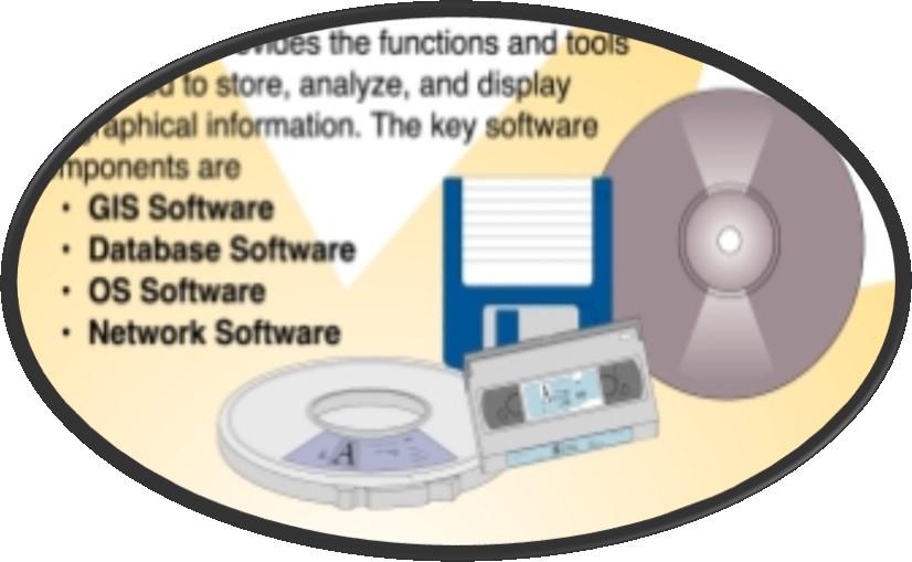
 Techniques for Science Teachers: Using GIS in Science Classrooms. After ESRI, 2008 GIS A Geographic Information System A collection of computer hardware, software, and geographic data used together for
ENV208/ENV508 Applied GIS. Week 1: What is GIS?
 ENV208/ENV508 Applied GIS Week 1: What is GIS? 1 WHAT IS GIS? A GIS integrates hardware, software, and data for capturing, managing, analyzing, and displaying all forms of geographically referenced information.
GEOGRAPHY. Parts/Units Topics Marks. Part A Fundamentals of Human Geography 35. Map Work 5. Part B India: People and Economy 35
 GEOGRAPHY Course Structure Parts/Units Topics Marks Part A Fundamentals of Human Geography 35 Unit 1 Unit 2 Unit 3 Unit 4 Unit 5 Human Geography People Human Activities Transport, Communication & Trade
An Introduction to Geographic Information System
 An Introduction to Geographic Information System PROF. Dr. Yuji MURAYAMA Khun Kyaw Aung Hein 1 July 21,2010 GIS: A Formal Definition A system for capturing, storing, checking, Integrating, manipulating,
INSTITUTE OF AERONAUTICAL ENGINEERING (Autonomous) Dundigal, Hyderabad
 Dundigal, Hyderabad") INSTITUTE OF AERONAUTICAL ENGINEERING (Autonomous) Dundigal, Hyderabad -00 0 CIVIL ENGINEERING TUTORIAL QUESTION BANK Course Name : Remote Sensing and GIS Course Code : A00 Class : IV B. Tech I Semester
INSTITUTE OF AERONAUTICAL ENGINEERING (Autonomous) Dundigal, Hyderabad -00 0 CIVIL ENGINEERING TUTORIAL QUESTION BANK Course Name : Remote Sensing and GIS Course Code : A00 Class : IV B. Tech I Semester
Sampling The World. presented by: Tim Haithcoat University of Missouri Columbia
 Sampling The World presented by: Tim Haithcoat University of Missouri Columbia Compiled with materials from: Charles Parson, Bemidji State University and Timothy Nyerges, University of Washington Introduction
Satellites, Weather and Climate Module 1: Introduction to the Electromagnetic Spectrum
 Satellites, Weather and Climate Module 1: Introduction to the Electromagnetic Spectrum What is remote sensing? = science & art of obtaining information through data analysis, such that the device is not
GIS Workshop Data Collection Techniques
 GIS Workshop Data Collection Techniques NOFNEC Conference 2016 Presented by: Matawa First Nations Management Jennifer Duncan and Charlene Wagenaar, Geomatics Technicians, Four Rivers Department QA #: FRG
DEVELOPMENT AND APPLICATION OF HIGH- RESOLUTION GIS-BASED ATLAS TO ENHANCE WATERSHED MANAGEMENT IN THE PHILIPPINES
 DEVELOPMENT AND APPLICATION OF HIGH- RESOLUTION GIS-BASED ATLAS TO ENHANCE WATERSHED MANAGEMENT IN THE PHILIPPINES Nathaniel C. Bantayan Institute of Renewable Natural Resources College of Forestry and
Site Suitability Analysis for Local Airport Using Geographic Information System
 Cloud Publications International Journal of Advanced Remote Sensing and GIS 2018, Volume 7, Issue 1, pp. 2719-2727 ISSN 2320 0243, Crossref: 10.23953/cloud.ijarsg.368 Research Article Site Suitability
International Journal of Intellectual Advancements and Research in Engineering Computations
 ISSN:2348-2079 Volume-5 Issue-2 International Journal of Intellectual Advancements and Research in Engineering Computations Agricultural land investigation and change detection in Coimbatore district by
State of Israel Ministry of Housing and Construction Survey of Israel. The Hydrological project case
 State of Israel Ministry of Housing and Construction Survey of Israel The Hydrological project case Survey of Israel Content Introduction To the Survey of Israel The operation assumptions The main responsibilities
What is Geography? Lecture 1 The Earth As A Rotating Planet. What is Geography? What is geography? Subfields of Geography?
 Lecture 1 The Earth As A Rotating Planet Geog210 Physical Geography What is Geography? Much more than place names and locations The study of spatial variation How and why things differ from place to place
Applying Hazard Maps to Urban Planning
 Applying Hazard Maps to Urban Planning September 10th, 2014 SAKAI Yuko Disaster Management Expert JICA Study Team for the Metro Cebu Roadmap Study on the Sustainable Urban Development 1 Contents 1. Outline
Remote sensing data uses and supply in Vietnam. Dr. Chu Hải Tùng National Remote Sensing Department, Ministry of Natural Resource and Environment
 Remote sensing data uses and supply in Vietnam Dr. Chu Hải Tùng National Remote Sensing Department, Ministry of Natural Resource and Environment Content Uses of remote sensing data in Vietnam Roles of
What is GIS? Introduction to data. Introduction to data modeling
 What is GIS? Introduction to data Introduction to data modeling 2 A GIS is similar, layering mapped information in a computer to help us view our world as a system A Geographic Information System is a
Climate Change and Biomes
 Climate Change and Biomes Key Concepts: Greenhouse Gas WHAT YOU WILL LEARN Biome Climate zone Greenhouse gases 1. You will learn the difference between weather and climate. 2. You will analyze how climate
Geomatics: Geotechnologies in Action, Grade 12, University/College Expectations
 Geographic Foundations: Space and Systems SSV.01 explain how the earth is modelled for scientific and mapping purposes; SSV.02 demonstrate an understanding of basic spatial concepts; Page 1 SSV.03 explain
Geography involves the study of places: their locations, their characteristics, and how humans use and move around them.
 Physical Geography Looking at the Earth Geography involves the study of places: their locations, their characteristics, and how humans use and move around them. NEXT Physical Geography Looking at the Earth
Principles of Satellite Remote Sensing
 Chapter 5 Principles of Satellite Remote Sensing Goal: Give a overview on the characteristics of satellite remote sensing. Satellites have several unique characteristics which make them particularly useful
RADAR Remote Sensing Application Examples
 RADAR Remote Sensing Application Examples! All-weather capability: Microwave penetrates clouds! Construction of short-interval time series through cloud cover - crop-growth cycle! Roughness - Land cover,
Landuse and Landcover change analysis in Selaiyur village, Tambaram taluk, Chennai
 Landuse and Landcover change analysis in Selaiyur village, Tambaram taluk, Chennai K. Ilayaraja Department of Civil Engineering BIST, Bharath University Selaiyur, Chennai 73 ABSTRACT The synoptic picture
Last date for submission of Assignments is Title of the course: PGD-GARD - II Semester. Third Batch (2018) - ASSIGNMENT
 - ASSIGNMENT") Last date for submission of Assignments is 31-12-2018 Title of the course: PGD-GARD - II Semester Third Batch (2018) - ASSIGNMENT Course No. GARD-507: Course Title: Remote Sensing -II Total Marks: 30 Note:
Last date for submission of Assignments is 31-12-2018 Title of the course: PGD-GARD - II Semester Third Batch (2018) - ASSIGNMENT Course No. GARD-507: Course Title: Remote Sensing -II Total Marks: 30 Note:
New NASA Ocean Observations and Coastal Applications
 New NASA Ocean Observations and Coastal Applications Duane Armstrong Chief, Applied Science & Technology Project Office August 20, 2014 1 Outline NASA s new Earth Science Ocean Science Missions for 2014
Remote Sensing I: Basics
 Remote Sensing I: Basics Kelly M. Brunt Earth System Science Interdisciplinary Center, University of Maryland Cryospheric Science Laboratory, Goddard Space Flight Center kelly.m.brunt@nasa.gov (Based on
Land Administration and Cadastre
 Geomatics play a major role in hydropower, land and water resources and other infrastructure projects. Lahmeyer International s (LI) worldwide projects require a wide range of approaches to the integration
Green Space Services for Local Monitoring
 Green Space Services for Local Monitoring Aratos Group V3.0 2016/08 Value added services for the society using space and satellite technologies Aratos Group 2 One of the first European downstream value
Lesson Plan 2 - Middle and High School Land Use and Land Cover Introduction. Understanding Land Use and Land Cover using Google Earth
 Understanding Land Use and Land Cover using Google Earth Image an image is a representation of reality. It can be a sketch, a painting, a photograph, or some other graphic representation such as satellite
Copernicus Overview. Major Emergency Management Conference Athlone 2017
 Copernicus Overview Major Emergency Management Conference Athlone 2017 Copernicus is a European programme implemented by the European Commission. The services address six thematic areas: land, marine,
Looking at Communities: Comparing Urban and Rural Neighborhoods
 Looking at Communities: Comparing Urban and Rural Neighborhoods OVERVIEW & OBJECTIVES Our urban areas have become so dominant that frequently the children we teach have no connection with and very few
Chapter 1: Introduction
 Chapter 1: Introduction Photogrammetry: Definition & applications What are we trying to do? Data acquisition systems 3-D viewing of 2-D imagery Automation (matching problem) Necessary tools: Image formation
Introduction to GIS. Geol 4048 Geological Applications of Remote Sensing
 Introduction to GIS Geol 4048 Geological Applications of Remote Sensing GIS History: Before Computers GIS History Using maps for a long time Dr. Roger F. Tomlinson Father of GIS He was an English geographer
Quality and Coverage of Data Sources
 Quality and Coverage of Data Sources Objectives Selecting an appropriate source for each item of information to be stored in the GIS database is very important for GIS Data Capture. Selection of quality
Colorado Academic Standards for High School Science Earth Systems Science
 A Correlation of Pearson 12 th Edition 2015 Colorado Academic Standards Introduction This document demonstrates the alignment between, 12 th Edition, 2015, and the, Earth Systems Science. Correlation page
sentinel-2 COLOUR VISION FOR COPERNICUS
 sentinel-2 COLOUR VISION FOR COPERNICUS SATELLITES TO SERVE By providing a set of key information services for a wide range of practical applications, Europe s Copernicus programme is providing a step
Introduction-Overview. Why use a GIS? What can a GIS do? Spatial (coordinate) data model Relational (tabular) data model
 data model Relational (tabular) data model") Introduction-Overview Why use a GIS? What can a GIS do? How does a GIS work? GIS definitions Spatial (coordinate) data model Relational (tabular) data model intro_gis.ppt 1 Why use a GIS? An extension
Introduction-Overview Why use a GIS? What can a GIS do? How does a GIS work? GIS definitions Spatial (coordinate) data model Relational (tabular) data model intro_gis.ppt 1 Why use a GIS? An extension
Cell-based Model For GIS Generalization
 Cell-based Model For GIS Generalization Bo Li, Graeme G. Wilkinson & Souheil Khaddaj School of Computing & Information Systems Kingston University Penrhyn Road, Kingston upon Thames Surrey, KT1 2EE UK
Lecture 4: Meteorological Satellites and Instruments. Acknowledgement: Dr. S. Kidder at Colorado State Univ.
 Lecture 4: Meteorological Satellites and Instruments Acknowledgement: Dr. S. Kidder at Colorado State Univ. Homework for the Spring Break: get some tangible, preliminary results for your final project.
Prentice Hall Science Explorer 2005, The Nature of Science and Technology (Book P) Correlated to: Indiana Academic Standards for Science (Grade 6)
 Correlated to: Indiana Academic Standards for Science (Grade 6)") Prentice Hall Science Explorer 2005, The Nature of Science and Technology (Book P) Indiana Academic Standards for Science (Grade 6) Grade 6 Standard 1 The Nature of Science and Technology Students design
Prentice Hall Science Explorer 2005, The Nature of Science and Technology (Book P) Indiana Academic Standards for Science (Grade 6) Grade 6 Standard 1 The Nature of Science and Technology Students design
Class 4J Autumn Term St. Lucia Adapted from QCA Geography Unit 10 incorporating some elements of Unit 25
 Class 4J Autumn Term 2002 Geography St. Lucia Geography Unit 10 incorporating some elements of Unit 25 ABOUT THE UNIT In this unit children develop ideas about a less economically developed country. When
Remote Sensing and GIS Techniques for Monitoring Industrial Wastes for Baghdad City
 The 1 st Regional Conference of Eng. Sci. NUCEJ Spatial ISSUE vol.11,no.3, 2008 pp 357-365 Remote Sensing and GIS Techniques for Monitoring Industrial Wastes for Baghdad City Mohammad Ali Al-Hashimi University
Geographical Information System (GIS) Prof. A. K. Gosain
 Prof. A. K. Gosain") Geographical Information System (GIS) Prof. A. K. Gosain gosain@civil.iitd.ernet.in Definition of GIS GIS - Geographic Information System or a particular information system applied to geographical data
Geographical Information System (GIS) Prof. A. K. Gosain gosain@civil.iitd.ernet.in Definition of GIS GIS - Geographic Information System or a particular information system applied to geographical data
CGMS Baseline. Sustained contributions to the Global Observing System. Endorsed by CGMS-46 in Bengaluru, June 2018
 CGMS Baseline Sustained contributions to the Global Observing System Best Practices for Achieving User Readiness for New Meteorological Satellites Endorsed by CGMS-46 in Bengaluru, June 2018 CGMS/DOC/18/1028862,
netw rks Guided Reading Activity Essential Question: How does geography influence the way people live? What Is Geography?
 Guided Reading Activity What Is Geography? Lesson 1 Thinking Like a Geographer Essential Question: How does geography influence the way people live? Directions: Read the lesson and use your textbook to
Geography & Technology. Geography of Canada
 Geography & Technology Geography of Canada www.craigmarlatt.com/school Geography & Technology 1. Geographic Informationn Systems 2. Global Positioning System 3. Aerial Photographs 4. Satellite Imagery
STUDY GUIDE. Exploring Geography. Chapter 1, Section 1. Terms to Know DRAWING FROM EXPERIENCE ORGANIZING YOUR THOUGHTS
 For use with textbook pages 19 22. Exploring Geography Terms to Know location A specific place on the earth (page 20) absolute location The exact spot at which a place is found on the globe (page 20) hemisphere
Tornado Alley (K-12) Virginia Standards of Learning. Kindergarten. Scientific Investigation, Reasoning, and Logic. Force, Motion, and Energy
 Virginia Standards of Learning. Kindergarten. Scientific Investigation, Reasoning, and Logic. Force, Motion, and Energy") Kindergarten K.1 The student will conduct investigations in which a) basic properties of objects are identified by direct observation; b) observations are made from multiple positions to achieve different
Kindergarten K.1 The student will conduct investigations in which a) basic properties of objects are identified by direct observation; b) observations are made from multiple positions to achieve different
Regional GIS Initiatives Geospatial Technology Center
 Regional GIS Initiatives Geospatial Technology Center Mr. Bobby Lear GIS Coordinator St. James Parish & Dr. Balaji Ramachandran Contractors Educational Trust Fund Endowed Professor Geomatics Program, Department
Geo-information and Disaster Risk Reduction in the Hindu Kush-Himalayan region
 Geo-information and Disaster Risk Reduction in the Hindu Kush-Himalayan region Basanta Shrestha, Division Head MENRIS, International Centre for Integrated Mountain Development Kathmandu, Nepal The International
Geographic Information Infrastructure and Policy Framework for Sustainable Mountain Development in the Hindu Kush-Himalayas
 Geo SMART ASIA 2017 22-24 August, Kualalampur Geographic Information Infrastructure and Policy Framework for Sustainable Mountain Development in the Hindu Kush-Himalayas Basanta Shrestha, Director Strategic
DATA SOURCES AND INPUT IN GIS. By Prof. A. Balasubramanian Centre for Advanced Studies in Earth Science, University of Mysore, Mysore
 DATA SOURCES AND INPUT IN GIS By Prof. A. Balasubramanian Centre for Advanced Studies in Earth Science, University of Mysore, Mysore 1 1. GIS stands for 'Geographic Information System'. It is a computer-based
Advanced Image Analysis in Disaster Response
 Advanced Image Analysis in Disaster Response Creating Geographic Knowledge Thomas Harris ITT The information contained in this document pertains to software products and services that are subject to the
Potential and limitations of remote sensing for cadastre and land management
 Potential and limitations of remote sensing for cadastre and land management Potentiel et limites de la télédétection pour les applications foncières Laurent Polidori École Supérieure des Géomètres et
Course Syllabus. Geospatial Data & Spatial Digital Technologies: Assessing Land Use/Land Cover Change in the Ecuadorian Amazon.
 Course Syllabus Geospatial Data & Spatial Digital Technologies: Assessing Land Use/Land Cover Change in the Ecuadorian Amazon Co- Instructors Dr. Carlos F. Mena, Universidad San Francisco de Quito, Ecuador
Historical background
 Space Technology for Disaster Management in Sri Lanka: Country profile, national perspectives & vision. Professor Ranjith Premalal De Silva Vice Chancellor Uva Wellassa University of Sri Lanka October
Ocean s Influence on Weather and Climate
 Earth is often called the Blue Planet because so much of its surface (about 71%) is covered by water. Of all the water on Earth, about 96.5%, is held in the world s oceans. As you can imagine, these oceans
Copernicus Overview and Emergency Management Service
 Copernicus Overview and Emergency Management Service Frédéric BASTIDE European Commission Open informal session of the United Nations Inter-Agency Meeting on Outer Space Activities 12 March 2013, Geneva
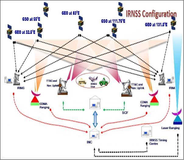
Indian Earth Observation Programme
 Indian Earth Observation Programme Dr. Jai Singh Parihar Dy. Director Remote Sensing Applications Area (RESA) Space Applications Centre (ISRO) Ahmedabad 380 015 India jsparihar@sac.isro.gov.in Presentation
Range of Opportunities
 Geograhy Curriculum Cropwell Bishop Primary School Range of Opportunities Year 1 Year 2 Year 3 Year 4 Year 5 Year 6 All Key Stage 1 Key Stage 2 Investigate the countries and capitals of the United Kingdom.
Quick Response Report #126 Hurricane Floyd Flood Mapping Integrating Landsat 7 TM Satellite Imagery and DEM Data
 Quick Response Report #126 Hurricane Floyd Flood Mapping Integrating Landsat 7 TM Satellite Imagery and DEM Data Jeffrey D. Colby Yong Wang Karen Mulcahy Department of Geography East Carolina University
CARTOGRAPHIC INFORMATION MANAGEMENT IN COLOMBIA REACH A LEVEL OF PERFECTION
 CARTOGRAPHIC INFORMATION MANAGEMENT IN COLOMBIA REACH A LEVEL OF PERFECTION Jaime Alberto Duarte Castro 1 Carrera 30 No. 48 51 Bogotá - Colombia, jduarte@igac.gov.co Claudia Inés Sepúlveda Fajardo 2 Carrera
Chapter 5. GIS The Global Information System
 Chapter 5 GIS The Global Information System What is GIS? We have just discussed GPS a simple three letter acronym for a fairly sophisticated technique to locate a persons or objects position on the Earth
Campus: VALLEY VIEW HIGH SCHOOL Content Area: Social Studies
 Campus: VALLEY VEW HGH SCHOOL : Map Name: Grading Period: 1 1A 21A 21B 21D 21E 22A 22B 22C 22D 3A 3B Description, TEKS Concept and Description analyze the effects of physical and human ggraphic patterns
Spanish national plan for land observation: new collaborative production system in Europe
 ADVANCE UNEDITED VERSION UNITED NATIONS E/CONF.103/5/Add.1 Economic and Social Affairs 9 July 2013 Tenth United Nations Regional Cartographic Conference for the Americas New York, 19-23, August 2013 Item
Using 3D Geographic Information System to Improve Sales Comparison Approach for Real Estate Valuation
 XXV FIG Congress, Kuala Lumpur, Malaysia TS02E-3D Using 3D Geographic Information System to Improve Sales Comparison Approach for Real Estate Valuation Haicong Yu Center for Assessment and Development
Louisiana Transportation Engineering Conference. Monday, February 12, 2007
 Louisiana Transportation Engineering Conference Monday, February 12, 2007 Agenda Project Background Goal of EIS Why Use GIS? What is GIS? How used on this Project Other site selection tools I-69 Corridor
UNITED NATIONS E/CONF.96/CRP. 5
 UNITED NATIONS E/CONF.96/CRP. 5 ECONOMIC AND SOCIAL COUNCIL Eighth United Nations Regional Cartographic Conference for the Americas New York, 27 June -1 July 2005 Item 5 of the provisional agenda* COUNTRY