SLOPE HAZARD AND RISK MAPPING: A TECHNOLOGICAL PERSPECTIVE
|
|
|
- Todd Hunt
- 5 years ago
- Views:
Transcription

1 International Symposium on Multi-Hazard and Risk March 2015, UTM Kuala Lumpur SLOPE HAZARD AND RISK MAPPING: A TECHNOLOGICAL PERSPECTIVE Very high resolution DTM derived from LiDAR LiDAR Ortho image By: Dato Zakaria Mohamad Project Manager PBRC MINERALS AND GEOSCIENCE DEPARTMENT MALAYSIA MINISTRY OF NATURAL RESOURCES AND ENVIRONMENT MALAYSIA


2 Slope Hazard and Risk Mapping in the Tropics: Why it is a challenging task? In the monsoon-dominated regions, landslides occur in areas characterized by steep hillslopes, high rainfall intensities, seasonally dry periods, unstable slopes and also under forests. Landslide inventory maps are fundamental for assessing landslide susceptibility, hazard, and risk. The compilation of landslide inventory maps is a tedious procedure due to the fact that each individual landslide has to be mapped and described together with their characteristics according to standard practices. Conventional landslide mapping techniques (aerial photos have limitations in a forested mountainous environment >> multi-sensor LIDAR is a promising tool for solving an old geological problem!!

3 RISK ASSESSMENT: CHALLENGES AND ISSUES Gunung Pass, Perak Malaysia Batu Caves, Selangor, Malaysia

4 Current scenarios of landslides in Malaysia Photos of landslides and their impact towards human lives and infrastructure, e.g. road and building are prevailed.


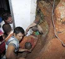
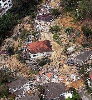
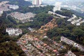
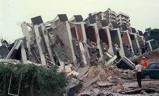
5 Hulu Langat 2010 Bukit Antarabangsa 2008 Highland Tower 1993 Bukit Antarabangsa 2008


6 Sivan Temple 2011 Lebuhraya Mahameru 2014 Bukit Antarabangsa 1999
7 PBRC PROJECT OBJECTIVES To produce slope hazard and risk information in the selected areas for the local authorities in Malaysia for a better slope management. To provide conceptual proposal and cost estimation for mitigating and strengthening high risky slopes. To assist government agencies and local authorities in land-use planning towards a sustainable land management. To develop geospatial infrastructure for national geological terrain and slope information.
 Ipoh (300 km 2 ) Kota Kinabalu (175 km 2 ) Cameron Highlands (400 km 2 )")
 Hazard and risk mapping Kapit (100 km 2 ) Landslide prone")
8 Landslide Inventory Map For Peninsular Malaysia/East Malaysia (National Slope Master Plan) Kundasang (50 km 2 ) Ipoh (300 km 2 ) Kota Kinabalu (175 km 2 ) Cameron Highlands (400 km 2 ) Bukit Frasers (100 km 2 ) Rawang-Batang Kali (150 km 2 ) Gombak-Kajang- Selayang (300 km 2 ) Cheras Selatan- Bangi (200 km 2 ) Hazard and risk mapping Kapit (100 km 2 ) Landslide prone area
")
9 PBRC PROJECT AREA IN SELANGOR (650 km 2 )

10 PBRC PROJECT AREA IN CAMERON HIGHLANDS (275 km 2 )

11 PBRC PROJECT AREA IN IPOH (200 km 2 )


12 Conceptual Framework Landslide Hazard and Risk Mapping Airborne LIDAR; 2. Terrestrial LIDAR, 3. GPS Survey, 4. Mobile GIS Field Mapping, 5. Data Processing, 6. LIDAR-Landslide Processing, 7. Landslide Inventory Mapping, 8. Landslide susceptibility Analysis, 9. Landslide Hazard Assessment, 10. Landslide Risk Assessment

13 Methodological Flow Quantitative Landslide Risk Assessment
, Cameron Highlands and Ipoh")
14 LiDAR Data Acquisition in Klang Valley (Selangor), Cameron Highlands and Ipoh
15 Classified Point Clouds as Ground over Terrain Shaded Relief of very high resolution DTM derived from LiDAR Sample: Klang Valley

16 Classified Point Clouds as Ground over Terrain Shaded Relief of very high esolution DTM derived from LiDAR Ortho image Sample: Klang Valley


17 Bukit Antarabangsa Orthophoto Digital Terrain Model Source: RS GIS

, Bukit")
18 Source: RS GIS LiDAR Point Cloud (Cross section), Bukit Antarabangsa


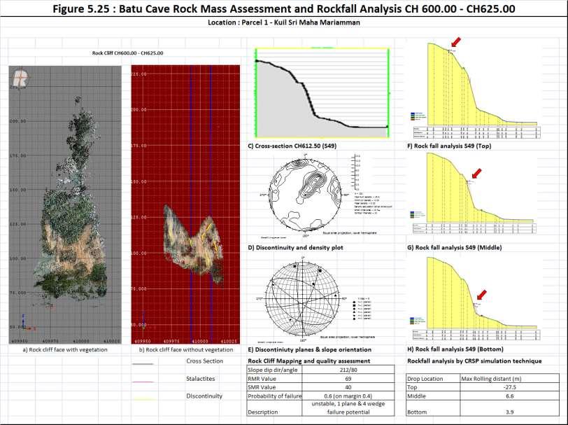
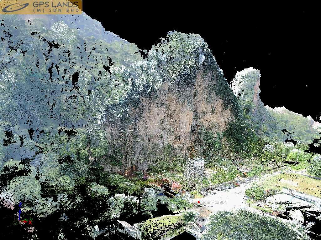
19 LIMESTONE CLIFF MAPPING USING TERRESTRIAL LASER SCANNING, BATU CAVES, SELANGOR MALAYSIA Colorized point cloud derived from TLS LIDAR Stage 1 Planning & Pre-survey Stage 2 Data Collection Stage 3 - Data Processing and Analysis Long range TLS scanner
 Peculiar characteristic of natural rocky limestone.")
20 Rock slope characteristics revealed by hyperspatial TLS data (Batu Caves, Selangor). A) Usual geometric terrain of rock slope. B) Peculiar characteristic of natural rocky limestone. C) An entire of cross sections coupled with rock cliff boundary and contour line used for geological and geotechnical assessment.
21
, Klang Valley Source: GPS")
22 TLS Ortho Image from the Permatang Kuarza Selangor (Klang Gate Quartz Ridge), Klang Valley Source: GPS Land

23 TLS Ortho Image at Kg. Dumpirin, Kundasang, Sabah Source: GPS Land
24 CONCLUSION 1. Methodological working framework for slope hazard and risk mapping has been developed for PBRC project 2. Multi sensor (airborne and terrestrial) system is a critical tool for providing an accurate geospatial data input (very high resolution DTM and DSM) for landslide hazard and risk assessment in the tropics. 3. PBRC creates a platform for developing a comprehensive landslide inventory using LiDAR technology for regional and national purposes. 4. PBRC promotes multi-disciplinary and knowledge-based approach for complex landslide assessment and disaster risk reduction initiative in Malaysia.
25


26 Thank you
Topographic Laser Scanning of Landslide Geomorphology System: Some Practical and Critical Issues
 Topographic Laser Scanning of Landslide Geomorphology System: Some Practical and Critical Issues Khamarrul Azahari Razak, Rozaimi Che Hasan UTM Razak School of Engineering and Advanced Technology, UTM
Advanced Geospatial Data for Cascading Geo-Hazard and Disaster Risk Assessment: A case study of 2015 earthquakes in Sabah
 Advanced Geospatial Data for Cascading Geo-Hazard and Disaster Risk Assessment: A case study of 2015 earthquakes in Sabah Presented at the FIG Working Week 2016, May 2-6, 2016 in Christchurch, New Zealand
GIS Based Landslide Hazard Mapping Prediction in Ulu Klang, Malaysia
 ITB J. Sci. Vol. 42 A, No. 2, 2010, 163-178 163 GIS Based Landslide Hazard Mapping Prediction in Ulu Klang, Malaysia 1,2 Muhammad Mukhlisin, 1 Ilyias Idris, 1 Al Sharif Salazar, 1 Khairul Nizam & 1 Mohd
To achieve these Global Sustainable Development Goals, geospatial data are crucial.
 To achieve these Global Sustainable Development Goals, geospatial data are crucial. 2 http://www.globalgoals.org/ HIGH INCOME NATION SUSTAINABLE GROWTH SOCIALLY INCLUSIVE 3 http://etp.pemandu.gov.my/ 12
Integrated and Multi-Hazard Disaster Management
 GeoSmart Asia 2016: GI for Disaster Preparedness and Risk Reduction Bandung, Indonesia 12 October 2016 Integrated and Multi-Hazard Disaster Management Lim Choun Sian & Nurfashareena Muhamad Centre for
Topographical Change Monitoring for Susceptible Landslide Area Determination by Using Multi-Date Digital Terrain Models and LiDAR
 Topographical Change Monitoring for Susceptible Landslide Area Determination by Using Multi-Date Digital Terrain Models and Chanist PRASERTBURANAKUL 1, Parkorn SUWANICH 2, Kanchana NAKHAPAKORN 3, and Sukit
GEOTECHNICAL RISK AND SUSTAINABLE PRACTICES : LESSON LEARNED AND A WAY FORWARD
 GEOTECHNICAL RISK AND SUSTAINABLE PRACTICES : LESSON LEARNED AND A WAY FORWARD IR. ZAINAB BINTI MOHAMED. PhD GEOTECHNICAL ENGINEERING AND GEORISK MANAGEMENT INSTITUTE FOR INFRASTRUCTURE ENGINEERING AND
Integrating LiDAR data into the workflow of cartographic representation.
 Integrating LiDAR data into the workflow of cartographic representation. Cartographic Workflow I. 1 2 3 4 5 Surveying Vector (Nat. GDB) GPS, Laser Range Finder Yes/ No Scanning old maps LiDARflights Capture
Governance, Geo-ICT and the Use of Indicators in Spatial Decision Making
 Governance, Geo-ICT and the Use of Indicators in Spatial Decision Making Dr. Johannes Flacke Assistant Professor for Spatial Planning and Decision Support Systems July 2 nd 2008 INTERNATIONAL INSTITUTE
GEOMATICS. Shaping our world. A company of
 GEOMATICS Shaping our world A company of OUR EXPERTISE Geomatics Geomatics plays a mayor role in hydropower, land and water resources, urban development, transport & mobility, renewable energy, and infrastructure
Terranum Sàrl. Rock-solid Expertise and Software
 Terranum Sàrl Rock-solid Expertise and Software About Founded in May 2011, Terranum Sàrl develops rock-solid expertise for natural hazards, geology, hydrology, 3D and LiDAR measurements, and customized
GEOGRAPHY (029) CLASS XI ( ) Part A: Fundamentals of Physical Geography. Map and Diagram 5. Part B India-Physical Environment 35 Marks
 CLASS XI ( ) Part A: Fundamentals of Physical Geography. Map and Diagram 5. Part B India-Physical Environment 35 Marks") GEOGRAPHY (029) CLASS XI (207-8) One Theory Paper 70 Marks 3 Hours Part A Fundamentals of Physical Geography 35 Marks Unit-: Geography as a discipline Unit-3: Landforms Unit-4: Climate Unit-5: Water (Oceans)
GEOGRAPHY (029) CLASS XI (207-8) One Theory Paper 70 Marks 3 Hours Part A Fundamentals of Physical Geography 35 Marks Unit-: Geography as a discipline Unit-3: Landforms Unit-4: Climate Unit-5: Water (Oceans)
Tatsuo Sekiguchi* and Hiroshi Sato*
 by Tatsuo Sekiguchi* and Hiroshi Sato* ABSTRACT Landslides induced by heavy rainfall and earthquakes may result in disaster by destroying homes and buildings. High-fluidity landslides caused by liquefied
Eagle Creek Post Fire Erosion Hazard Analysis Using the WEPP Model. John Rogers & Lauren McKinney
 Eagle Creek Post Fire Erosion Hazard Analysis Using the WEPP Model John Rogers & Lauren McKinney Columbia River Gorge at Risk: Using LiDAR and GIS-based predictive modeling for regional-scale erosion susceptibility
Landslide Susceptibility, Hazard, and Risk Assessment. Twin Hosea W. K. Advisor: Prof. C.T. Lee
 Landslide Susceptibility, Hazard, and Risk Assessment Twin Hosea W. K. Advisor: Prof. C.T. Lee Date: 2018/05/24 1 OUTLINE INTRODUCTION LANDSLIDE HAZARD ASSESSTMENT LOGISTIC REGRESSION IN LSA STUDY CASE
FLOOD PLAIN SIMULATION MODEL BY INTEGRATION OF SURVEYING PACKAGES AND GIS
 FLOOD PLAIN SIMULATION MODEL BY INTEGRATION OF SURVEYING PACKAGES AND GIS Azrinda Hassan Mohamad and Md.Nor Kamarudin Department of Geomatics Engineering, Faculty of Geoinformation Science and Engineering
Applying Hazard Maps to Urban Planning
 Applying Hazard Maps to Urban Planning September 10th, 2014 SAKAI Yuko Disaster Management Expert JICA Study Team for the Metro Cebu Roadmap Study on the Sustainable Urban Development 1 Contents 1. Outline
Zainuddin Md Yusoff*, Nur Anati Azmi, Haslinda Nahazanan, Nik Norsyahariati Nik Daud & Azlan Abd Aziz
 Malaysian Journal of Civil Engineering 28 Special Issue (1):35-41 (2016) TECHNICAL NOTE ENGINEERING GEOLOGICAL OF AN ACTIVE SLOPE IN KM46 SIMPANG PULAI, PERAK Zainuddin Md Yusoff*, Nur Anati Azmi, Haslinda
VISUALIZING THE SMART CITY 3D SPATIAL INFRASTRUCTURE GEOSMART ASIA- 30 SEP, 2015
 www.aamgroup.com VISUALIZING THE SMART CITY 3D SPATIAL INFRASTRUCTURE GEOSMART ASIA- 30 SEP, 2015 Agenda AAM What is a Smart City? Data Acquisition 3D Modelling Benefits Questions AAM AAM is a Geospatial
Natural Terrain Risk Management in Hong Kong
 Natural Terrain Risk Management in Hong Kong Nick Koor Senior Lecturer in Engineering Geology School of Earth and Environmental Sciences Slope failures in Hong Kong Man-made Slope Failure - 300 landslides
3D Slope Stability Analysis for Slope Failure Probability in Sangun mountainous, Fukuoka Prefecture, Japan
 3D Slope Stability Analysis for Slope Failure Probability in Sangun mountainous, Fukuoka Prefecture, Japan Hendra PACHRI (1), Yasuhiro MITANI (1), Hiro IKEMI (1), and Wenxiao JIANG (1) (1) Graduate School
Lessons learnt using GIS to map geological hazards following the Christchurch earthquake
 Gerrard, L.C, Herbert J.A & Revell T.A.J (2013) Proc. 19 th NZGS Geotechnical Symposium. Ed. CY Chin, Queenstown Lessons learnt using GIS to map geological hazards following the Christchurch earthquake
Tracy Fuller U. S. Geological Survey. February 24, 2016
 U. S. Geological Survey Arctic Elevation Data Involvement Statewide Alaska IfSAR Radar Collection Program Pan-Arctic Digital Elevation Map International Coordination Tracy Fuller U. S. Geological Survey
Airborne Corridor-Mapping. Planning and documentation of company infrastructure: precise, rapid, and cost effective
 Airborne Corridor-Mapping Planning and documentation of company infrastructure: precise, rapid, and cost effective Technology Airborne Laser-Scanning, digital orthophotos and thermal imaging: one flight
SCIENCE & TECHNOLOGY
 Pertanika J. Sci. & Technol. 21 (2): 473-486 (2013) SCIENCE & TECHNOLOGY Journal homepage: http://www.pertanika.upm.edu.my/ Landslide Susceptibility Mapping Using Averaged Weightage Score and GIS: A Case
SI Planning & Laboratory Testing for Hill-Site Development
 SI Planning & Laboratory Testing for Hill-Site Development 21 April 2009 IEM Penang Ir. Tan Yean Chin G&P Geotechnics Sdn Bhd Cameron Highlands, 1961 Genting Highland Tower 1993 Bukit Antarabangsa, 1999
Georeferencing and Satellite Image Support: Lessons learned, Challenges and Opportunities
 Georeferencing and Satellite Image Support: Lessons learned, Challenges and Opportunities Shirish Ravan shirish.ravan@unoosa.org UN-SPIDER United Nations Office for Outer Space Affairs (UNOOSA) UN-SPIDER
THE USE OF DIFFERENT REMOTE SENSING TECHNIQUES FOR LANDSLIDE CHARACTERIZATION
 THE USE OF DIFFERENT REMOTE SENSING TECHNIQUES FOR LANDSLIDE CHARACTERIZATION Ph.D. candidate: ANNA DE AGOSTINI Tutor: Dr. M. FLORIS Cycle: XXVI Abstract The aim of my research is to investigate the potential
Interpretive Map Series 24
 Oregon Department of Geology and Mineral Industries Interpretive Map Series 24 Geologic Hazards, and Hazard Maps, and Future Damage Estimates for Six Counties in the Mid/Southern Willamette Valley Including
USING GIS CARTOGRAPHIC MODELING TO ANALYSIS SPATIAL DISTRIBUTION OF LANDSLIDE SENSITIVE AREAS IN YANGMINGSHAN NATIONAL PARK, TAIWAN
 CO-145 USING GIS CARTOGRAPHIC MODELING TO ANALYSIS SPATIAL DISTRIBUTION OF LANDSLIDE SENSITIVE AREAS IN YANGMINGSHAN NATIONAL PARK, TAIWAN DING Y.C. Chinese Culture University., TAIPEI, TAIWAN, PROVINCE
ISSN (Print) Research Article
 Research Article") Scholars Journal of Engineering and Technology (SJET) Sch. J. Eng. Tech., 2016; 4(4):185-192 Scholars Academic and Scientific Publisher (An International Publisher for Academic and Scientific Resources)
Scholars Journal of Engineering and Technology (SJET) Sch. J. Eng. Tech., 2016; 4(4):185-192 Scholars Academic and Scientific Publisher (An International Publisher for Academic and Scientific Resources)
LANDSLIDE HAZARD MAPPING BY USING GIS IN THE LILLA EDET PROVINCE OF SWEDEN
 LANDSLIDE HAZARD MAPPING BY USING GIS IN THE LILLA EDET PROVINCE OF SWEDEN Arzu ERENER 1, Suzanne LACASSE 2, Amir M. KAYNIA 3 1 Geodetic and Geographic Information Technologies, Middle East Technical University,
Application of high-resolution (10 m) DEM on Flood Disaster in 3D-GIS
 DEM on Flood Disaster in 3D-GIS") Risk Analysis V: Simulation and Hazard Mitigation 263 Application of high-resolution (10 m) DEM on Flood Disaster in 3D-GIS M. Mori Department of Information and Computer Science, Kinki University, Japan
Risk Analysis V: Simulation and Hazard Mitigation 263 Application of high-resolution (10 m) DEM on Flood Disaster in 3D-GIS M. Mori Department of Information and Computer Science, Kinki University, Japan
Airborne LiDAR and Hyperspectral Data to Support the Seismic Vulnerability of Urban Environments
 Airborne LiDAR and Hyperspectral Data to Support the Seismic Vulnerability of Urban Environments Antonio Costanzo 1, Antonio Montuori 1, Juan Pablo Silva 2, Malvina Silvestri 3, Massimo Musacchio 3, Maria
Key words Surface radiation dose; Annual effective dose; Cancer risk
 DETERMINATION OF SURFACE RADIATION DOSE-RATE IN THE ENVIRONMENT OF KELATAN STATE MALAYSIA *NURADDEEN NASIRU GARBA, AHMAD TERMIZI BIN RAMLI, MUNEER AZIZ SALEH, HAMMAN TUKUR GABDO, ABUBAKAR SADIQ ALIYU,
12/05/2016. The First step in Adaptation to future climate change Reduce Vulnerability and Exposure to present Climate Variability (IPCC 2014)
") Integrating CCA, DRR and L+D to Address Emerging Challenges due to Slow Onset Processes Joy Jacqueline Pereira (Project Leader), SEADPRI-Universiti Kebangsaan Malaysia, Nguyen Van Thang (Collaborator),
Integrating CCA, DRR and L+D to Address Emerging Challenges due to Slow Onset Processes Joy Jacqueline Pereira (Project Leader), SEADPRI-Universiti Kebangsaan Malaysia, Nguyen Van Thang (Collaborator),
EIT-Japan Symposium 2011 on Human Security Engineering
 EIT-Japan Symposium 2011 on Human Security Engineering 2011 Disastrous Landslides at Khao Panom, Krabi, Thailand Suttisak Soralump Geotechnical Engineering Research and Development Center (GERD) Faculty
Experience in Stabilisation of Rock Slopes in Pahang Muhammad Hafeez Osman Intan Shafika Saiful Bahri Damanhuri Jamalludin Fauziah Ahmad
 Experience in Stabilisation of Rock Slopes in Pahang Muhammad Hafeez Osman Intan Shafika Saiful Bahri Damanhuri Jamalludin Fauziah Ahmad ABSTRACT Two cases regarding the histories of rock slopes repair
Monitoring of Hill-Slope Movement Due to Rainfall at Gunung Pass of Cameron Highland District of Peninsular Malaysia
 6 Monitoring of Hill-Slope Movement Due to Rainfall at Gunung Pass of Cameron Highland District of Peninsular Malaysia HABIBAH LATEH A, JEFRIZA A, W M MUHIYUDDIN B, BADDRUL TAIB A and YOUNUS AHMED KHAN
GEOMORPHOLOGY APPROACH IN LANDSLIDE VULNERABILITY, TANJUNG PALAS TENGAH, EAST KALIMANTAN, INDONESIA
 GEOMORPHOLOGY APPROACH IN LANDSLIDE VULNERABILITY, TANJUNG PALAS TENGAH, EAST KALIMANTAN, INDONESIA *Twin H. W. Kristyanto Geology Study Program, FMIPA UI, Universitas Indonesia *Author for Correspondence:
Location Analytics for Targeted Marketing. By Geomatics Development & Services, Telekom Malaysia Berhad
 Location Analytics for Targeted Marketing By Geomatics Development & Services, Telekom Malaysia Berhad I n t r o d u c t i o n Location Based Information critical in TM. Sales & Marketing Upsell activities
Disaster Management in Republic of Korea
 The Third UN-GGIM-AP Plenary Meeting Disaster Management in Republic of Korea ~Coordination among NGIA & Other Related Organizations and Recommendations~ Bali Indonesia 10 November 2014 Sanghoon Lee, Ph.D.
Geography Class XI Fundamentals of Physical Geography Section A Total Periods : 140 Total Marks : 70. Periods Topic Subject Matter Geographical Skills
 Geography Class XI Fundamentals of Physical Geography Section A Total Periods : 140 Total Marks : 70 Sr. No. 01 Periods Topic Subject Matter Geographical Skills Nature and Scope Definition, nature, i)
Papua New Guinea LiDAR Factsheet. Pacific-Australia Climate Change Science and Adaptation Planning. Vanimo. Bismark Sea. Wewak
 Pacific-Australia Climate Change Science and Adaptation Planning INDONESIA Vanimo Ninigo Group Wewak Madang Mount Hagen Kundiawa Goroka Mendi Daru AUSTRALIA Kerema Gulf of Papua Admiralty Islands Mussau
Effective Utilization of Synthetic Aperture Radar (SAR) Imagery in Rapid Damage Assessment
 Imagery in Rapid Damage Assessment") Effective Utilization of Synthetic Aperture Radar (SAR) Imagery in Rapid Damage Assessment Case Study Pakistan Floods SUPARCO M. Maisam Raza, Ahmad H. Rabbani SEQUENCE Flood Monitoring using Satellite
Effective Utilization of Synthetic Aperture Radar (SAR) Imagery in Rapid Damage Assessment Case Study Pakistan Floods SUPARCO M. Maisam Raza, Ahmad H. Rabbani SEQUENCE Flood Monitoring using Satellite
HYDROLOGIC AND WATER RESOURCES EVALUATIONS FOR SG. LUI WATERSHED
 HYDROLOGIC AND WATER RESOURCES EVALUATIONS FOR SG. LUI WATERSHED 1.0 Introduction The Sg. Lui watershed is the upper part of Langat River Basin, in the state of Selangor which located approximately 20
GIS BASED ANALYSIS ON ENVIRONMENTAL SENSITIVE AREAS AND IDENTIFICATION OF THE POTENTIAL DISASTER HAZARDOUS LOCATIONS IN SOUTHERN SRI LANKA
 International Journal of Civil & Environmental Engineering IJCEE Vol: 9 No: 9-311 - GIS BASED ANALYSIS ON ENVIRONMENTAL SENSITIVE AREAS AND IDENTIFICATION OF THE POTENTIAL DISASTER HAZARDOUS LOCATIONS
INTRODUCTION. Climate
 INTRODUCTION Climate Landslides are serious natural disasters in many parts of the world. Since the past 30 years, rainfall triggered landslides and debris flows had been one of the natural disasters of
Assessment of the Incidence of Landslides Using Numerical Information
 PAPER Assessment of the Incidence of Landslides Using Numerical Information Atsushi HASEGAWA Takehiro OHTA, Dr. Sci. Assistant Senior Researcher, Senior Researcher, Laboratory Head, Geology Laboratory,
Preparation of Database for Urban Development
 Preparation of Database for Urban Development By PunyaP OLI, 1. Chairman, ERMC (P) Ltd., Kathmandu, Nepal. Email: punyaoli@ermcnepal.com 2. Coordinator, Himalayan College of Geomatic Engineering and Land
Roles of NGII in successful disaster management
 The Second UN-GGIM-AP Plenary Meeting Roles of NGII in successful disaster management Republic of Korea Teheran Iran 28 October 2013 Sanghoon Lee, Ph.D. NGII Outline Type of Disasters Occur in Korea Practical
The 3D Elevation Program: Overview. Jason Stoker USGS National Geospatial Program ESRI 2015 UC
 + The 3D Elevation Program: Overview Jason Stoker USGS National Geospatial Program ESRI 2015 UC + 2 A little history USGS has a long, proud tradition of mapmaking (2009) + 3 The changing times Mapping
Rate of Development of Ex-Mining Land in Peninsular Malaysia
 Rate of Development of Ex-Mining Land in Peninsular Malaysia Ramli Mohd Osman Mineral Research Centre, Minerals and Geoscience Department Malaysia Jalan Sultan Azlan Shah, 31400 Ipoh Email: ramli.osman@jmg.gov.my
Manitoba s Elevation (LiDAR) & Imagery Datasets. Acquisition Plans & Opportunities for Collaboration
 & Imagery Datasets. Acquisition Plans & Opportunities for Collaboration") Manitoba s Elevation (LiDAR) & Imagery Datasets Acquisition Plans & Opportunities for Collaboration Manitoba Planning Conference May 2017 Presentation Outline Manitoba s Elevation (LiDAR) and Imagery Datasets
Manitoba s Elevation (LiDAR) & Imagery Datasets Acquisition Plans & Opportunities for Collaboration Manitoba Planning Conference May 2017 Presentation Outline Manitoba s Elevation (LiDAR) and Imagery Datasets
Investigation of landslide based on high performance and cloud-enabled geocomputation
 Investigation of landslide based on high performance and cloud-enabled geocomputation Jun Liu 1, Shuguang Liu 2,*, Qiming Zhou 3, Jing Qian 1 1 Shenzhen Institutes of Advanced Technology, Chinese Academy
Geo-hazard Potential Mapping Using GIS and Artificial Intelligence
 Geo-hazard Potential Mapping Using GIS and Artificial Intelligence Theoretical Background and Uses Case from Namibia Andreas Knobloch 1, Dr Andreas Barth 1, Ellen Dickmayer 1, Israel Hasheela 2, Andreas
DEM-based Ecological Rainfall-Runoff Modelling in. Mountainous Area of Hong Kong
 DEM-based Ecological Rainfall-Runoff Modelling in Mountainous Area of Hong Kong Qiming Zhou 1,2, Junyi Huang 1* 1 Department of Geography and Centre for Geo-computation Studies, Hong Kong Baptist University,
Mapping a Nation in 3D Singapore s Journey. Bryan Chew Registrar of Titles Assistant Chief Executive Singapore Land Authority
 Mapping a Nation in 3D Singapore s Journey Bryan Chew Registrar of Titles Assistant Chief Executive Singapore Land Authority Singapore Size - 719 sq km Population - 5.5 million Density 7,600/sq km Singapore
2014 Summer training course for slope land disaster reduction Taipei, Taiwan, Aug
 MINISTRY OF SCIENCE AND TECHNOLOGY HYDROTECH RESEARCH INSTITUTE MINISTRY OF NATURAL RESOURCES AND ENVIRONMENT VIETNAM INSTITUTE OF GEOSCIENCES AND MINERAL RESOURCES (VIGMR) 2014 Summer training course
UNIVERSITI TEKNOLOGI MARA
 UNIVERSITI TEKNOLOGI MARA GEOGRAPHICAL INFORMATION SYSTEM (GIS) BASED MULTI CRITERIA DECISION MAKING (MCDM) FOR LANDSLIDE HAZARD ZONATION: A CASE STUDY OF AMPANG JAYA MUNICIPAL COUNCIL AINON NISA OTHMAN
Integrated GIS based approach in mapping the groundwater potential zones in Kota Kinabalu, Sabah, Malaysia
 Integrated GIS based approach in mapping the groundwater potential zones in Kota Kinabalu, Sabah, Malaysia Zulherry Isnain and Juhari Mat Akhir Faculty of Science and Natural Resources, Universiti Malaysia
By Chris Mikes and David Fleck Digital Terrain Analysis GEOG 593. Overview
 Earthquake and Infrastructure Damage Analysis in Multnomah and Clackamas Counties: The Application of LiDAR In The Development of an Emergency Response Plan By Chris Mikes and David Fleck Digital Terrain
An Investigation on One of the Rainfall-Induced Landslides in Malaysia
 An Investigation on One of the Rainfall-Induced Landslides in Malaysia Low Tian Huat Mohd Asbi & Associates, Malaysia. malvinlth@gmail.com Faisal Ali Department of Civil Engineering, Faculty of Engineering,
A METHODOLOGY FOR ASSESSING EARTHQUAKE-INDUCED LANDSLIDE RISK. Agency for the Environmental Protection, ITALY (
 A METHODOLOGY FOR ASSESSING EARTHQUAKE-INDUCED LANDSLIDE RISK Roberto W. Romeo 1, Randall W. Jibson 2 & Antonio Pugliese 3 1 University of Urbino, ITALY (e-mail: rwromeo@uniurb.it) 2 U.S. Geological Survey
2014 Summer Training Courses on Slope Land Disaster Reduction Hydrotech Research Institute, National Taiwan University, Taiwan August 04-15, 2014
 Final Project Report 2014 Summer Training Courses on Slope Land Disaster Reduction Hydrotech Research Institute, National Taiwan University, Taiwan August 04-15, 2014 Landslides in Mt. Umyeon Susceptibility
MANAGEMENT OF LARGE MUDSLIDES
 36 MANAGEMENT OF LARGE MUDSLIDES Three large and active mudslides Poche, 1860?, Super-Sauze, 1960?, La Valette, March 1982, 1 M m 3 900,000 m 3 4-5 M m 3 37 Three large and active mudslides Type of development:
NATIONAL FRAMEWORK FOR FLOOD DISASTER MANAGEMENT IN INDONESIA. 11 th GEOSS ASIA PASIFIC SYMPOSIUM Kyoto, October 2018
 NATIONAL FRAMEWORK FOR FLOOD DISASTER MANAGEMENT IN INDONESIA 11 th GEOSS ASIA PASIFIC SYMPOSIUM Kyoto, 24-26 October 2018 1 OUTLINE Disasters in Indonesia The Disaster Management Mechanism Current Status
The Safeland Project General Overview and Monitoring Technology Development
 Ber. Geol. B. A., 82, ISSN 1017 8880 Landslide Monitoring Technologies & Early Warning Systems The Safeland Project General Overview and Monitoring Technology Development The SafeLand Consortium a), N.
Land Administration and Cadastre
 Geomatics play a major role in hydropower, land and water resources and other infrastructure projects. Lahmeyer International s (LI) worldwide projects require a wide range of approaches to the integration
Norwegian spatial data infrastructure supporting disaster risk management Norwegian Mapping Authority
 Norwegian spatial data infrastructure supporting disaster risk management Norwegian Mapping Authority Arvid Lillethun, Norwegian Mapping Authority Land and Poverty 2018 Conference, World Bank 19.-23. March
Landslide Hazard Analysis at Jelapangof North-South Expressway in Malaysia Using High Resolution Airborne LiDAR Data
 Landslide Hazard Analysis at Jelapangof North-South Expressway in Malaysia Using High Resolution Airborne LiDAR Data NORBAZLAN MOHD YUSOF GEOSPATIAL WORLD FORUM 2015 Geospatial World Forum, Portugal 25-29
ESTIMATING LAND VALUE AND DISASTER RISK IN URBAN AREA IN YANGON, MYANMAR USING STEREO HIGH-RESOLUTION IMAGES AND MULTI-TEMPORAL LANDSAT IMAGES
 ESTIMATING LAND VALUE AND DISASTER RISK IN URBAN AREA IN YANGON, MYANMAR USING STEREO HIGH-RESOLUTION IMAGES AND MULTI-TEMPORAL LANDSAT IMAGES Tanakorn Sritarapipat 1 and Wataru Takeuchi 1 1 Institute
Towards National Geographic Information System in Nepal
 2 nd High Level Forum on Global Geospatial Information Management, Qatar National Convention Centre, Doha, Qatar, 4 6 February, 2013 Towards National Geographic Information System in Nepal Krishna Raj
A Data Fusion Approach to Real-time Monitoring Systems and Information Management
 Landslide Preparedness in the ASEAN Member States A Data Fusion Approach to Real-time Monitoring Systems and Information Management Jessada Karnjana, PhD National Electronics and Computer Technology Center
Roadmap to Stability
 Landslide Policy Committee for Aizawl City February 2014 Technical Support by: Aizawl is in earthquake hazard zone V and highly prone to natural, man-made and earthquake induced landslides. In order to
THE NEW DNR LANDSLIDE HAZARDS PROGRAM
 THE NEW DNR LANDSLIDE HAZARDS PROGRAM Kara Jacobacci, G.I.T. Landslide Hazards Program Washington Geological Survey Washington Department of Natural Resources LEGISLATIVE FUNDING 2015 session DNR requested
August 14, James Bolton 312 Perry Lane Lovingston, VA
 August 14, 2017 James Bolton 312 Perry Lane Lovingston, VA 22949 jrbolton035@gmail.com Department of Environmental Quality Office of Wetlands & Stream Protection P.O. Box 1105 Richmond, VA 23218 comment-acp@deq.virginia.gov
Hydrological parameters Controls Vulnerable Zones in Calicut Nilambur Gudalur Ghat section, Gudalur, The Nilgiris, Tamil Nadu.
 International Journal of ChemTech Research CODEN (USA): IJCRGG ISSN: 0974-4290 Vol.9, No.03 pp 248-253, 2016 Hydrological parameters Controls Vulnerable Zones in Calicut Nilambur Gudalur Ghat section,
GIS Application in Landslide Hazard Analysis An Example from the Shihmen Reservoir Catchment Area in Northern Taiwan
 GIS Application in Landslide Hazard Analysis An Example from the Shihmen Reservoir Catchment Area in Northern Taiwan Chyi-Tyi Lee Institute of Applied Geology, National Central University, No.300, Jungda
MAPPING POTENTIAL LAND DEGRADATION IN BHUTAN
 MAPPING POTENTIAL LAND DEGRADATION IN BHUTAN Moe Myint, Geoinformatics Consultant Rue du Midi-8, CH-1196, Gland, Switzerland moemyint@bluewin.ch Pema Thinley, GIS Analyst Renewable Natural Resources Research
Fugro Geospatial: Turning Spatial Data into Knowledge
 Fugro Geospatial: Turning Spatial Data into Knowledge 2016 Fugro Geospatial, GIS and Consultants Locations Variety of Collection Platforms Traditional Mapping Traditional Mapping Imagery Photogrammetric
Figure B.15 - Example of plotting the landslide potential points
 Figure B.15 - Example of plotting the landslide potential points Figure B.16 - Example of landslide potential map based on topographic factor in north area of kabupaten Jember 37 from 61 Figure B.17 -
Field Observation on Thermal Environment of an Urban Street with Roadside Trees in a Tropical Climate
 Field Observation on Thermal Environment of an Urban Street with Roadside Trees in a Tropical Climate Hai Jian Toh¹, Sheikh Ahmad Zaki¹, Aya Hagishima², Mohamed Sukri Mat Ali¹ 1 Universiti Teknologi Malaysia,
EO Information Services. Assessing Vulnerability in the metropolitan area of Rio de Janeiro (Floods & Landslides) Project
 Project") EO Information Services in support of Assessing Vulnerability in the metropolitan area of Rio de Janeiro (Floods & Landslides) Project Ricardo Armas, Critical Software SA Haris Kontoes, ISARS NOA World
EO Information Services in support of Assessing Vulnerability in the metropolitan area of Rio de Janeiro (Floods & Landslides) Project Ricardo Armas, Critical Software SA Haris Kontoes, ISARS NOA World
USING 3D GIS TO ASSESS ENVIRONMENTAL FLOOD HAZARDS IN MINA
 King Fahd University of Petroleum & Minerals College of Environmental Design Geographical Information system USING 3D GIS TO ASSESS ENVIRONMENTAL FLOOD HAZARDS IN MINA Prepared by : Ali AL-Zahrani OUTLINE
Landslide Hazard Assessment Methodologies in Romania
 A Scientific Network for Earthquake, Landslide and Flood Hazard Prevention SciNet NatHazPrev Landslide Hazard Assessment Methodologies in Romania In the literature the terms of susceptibility and landslide
Watershed Classification with GIS as an Instrument of Conflict Management in Tropical Highlands of the Lower Mekong Basin
 Page 1 of 8 Watershed Classification with GIS as an Instrument of Conflict Management in Tropical Highlands of the Lower Mekong Basin Project Abstract The University of Giessen is actually planning a research
Summary of Presentation:
 Development of Geodetic GPS Infrastructure and Its : The Malaysia Experience BY Abd Majid.A.Kadir, Shahrum Ses, Kamaluddin Omar & Abdullah Hisam Omar Fac. of Geoinformation Science and Eng. Universiti
INTERNATIONAL JOURNAL OF GEOMATICS AND GEOSCIENCES Volume 1, No 1, 2010
 An Integrated Approach with GIS and Remote Sensing Technique for Landslide Hazard Zonation S.Evany Nithya 1 P. Rajesh Prasanna 2 1. Lecturer, 2. Assistant Professor Department of Civil Engineering, Anna
ESTIMATION OF LANDFORM CLASSIFICATION BASED ON LAND USE AND ITS CHANGE - Use of Object-based Classification and Altitude Data -
 ESTIMATION OF LANDFORM CLASSIFICATION BASED ON LAND USE AND ITS CHANGE - Use of Object-based Classification and Altitude Data - Shoichi NAKAI 1 and Jaegyu BAE 2 1 Professor, Chiba University, Chiba, Japan.
Chapter 1 Overview of Maps
 Chapter 1 Overview of Maps In this chapter you will learn about: Key points when working with maps General types of maps Incident specific maps Map legend and symbols Map sources A map is a navigational
Themes for Geomatics Conference. Geodesy Themes
 Themes for Geomatics Conference Geodesy Themes Geodynamics o Modeling the Deformation of the Earth s Crust o Recent Advances in Geometric Approaches to Deformation Analysis o Monitoring Systems (Sensors
March 2007 The Survey Department of Sri Lanka
 Contribution of Survey Department of Sri Lanka for Mitigation of Disasters in Sri Lanka K.A.U.N.Kasthuri Deputy Surveyor General (Information Technology) March 2007 The Survey Department of Sri Lanka 1
THE IMPACT OF LANDSLIDE AREAS ON MUNICIPAL SPATIAL PLANNING
 THE IMPACT OF LANDSLIDE AREAS ON MUNICIPAL SPATIAL PLANNING Jarosław Bydłosz, PhD Faculty of Mining Surveying and Environmental Engineering AGH University of Science and Technology e-mail: bydlosz@agh.edu.pl
The Use of Spatial Analysis Techniques in Mapping Potential Natural Hazard Areas: A Case Study of Taiwan.
 Available online at www.sciencedirect.com Procedia Environmental Sciences 10 (2011 ) 1092 1097 2011 3rd International Conference on Environmental 2011 3rd International Science Conference and Information
Philippines NSDI Foundation Data Program. Andrew Bashfield
 Philippines NSDI Foundation Data Program Andrew Bashfield 1 Overview Part 1: Building the NSDI Framework Part 2: Collecting Foundation Datasets 2 Building the NSDI Framework Background & NDSI Overview
APPLICATION OF REMOTE SENSING & GIS ON LANDSLIDE HAZARD ZONE IDENTIFICATION & MANAGEMENT
 APPLICATION OF REMOTE SENSING & GIS ON LANDSLIDE HAZARD ZONE IDENTIFICATION & MANAGEMENT PRESENTED BY SUPRITI PRAMANIK M.TECH IN ENVIRONMENTAL SCIENCE AND TECHNOLOGY NIT,DURGAPUR 25-04-2015 1 INTRODUCTION
Neotectonic Implications between Kaotai and Peinanshan
 Neotectonic Implications between Kaotai and Peinanshan Abstract Longitudinal Valley was the suture zone between the Philippine Sea plate and the Eurasia plate. Peinanshan was the southest segment of the
Virtual Reality Modeling of Landslide for Alerting in Chiang Rai Area Banphot Nobaew 1 and Worasak Reangsirarak 2
 Virtual Reality Modeling of Landslide for Alerting in Chiang Rai Area Banphot Nobaew 1 and Worasak Reangsirarak 2 1 Banphot Nobaew MFU, Chiang Rai, Thailand 2 Worasak Reangsirarak MFU, Chiang Rai, Thailand
PROANA A USEFUL SOFTWARE FOR TERRAIN ANALYSIS AND GEOENVIRONMENTAL APPLICATIONS STUDY CASE ON THE GEODYNAMIC EVOLUTION OF ARGOLIS PENINSULA, GREECE.
 PROANA A USEFUL SOFTWARE FOR TERRAIN ANALYSIS AND GEOENVIRONMENTAL APPLICATIONS STUDY CASE ON THE GEODYNAMIC EVOLUTION OF ARGOLIS PENINSULA, GREECE. Spyridoula Vassilopoulou * Institute of Cartography