To achieve these Global Sustainable Development Goals, geospatial data are crucial.
|
|
|
- Miles Lynch
- 5 years ago
- Views:
Transcription


1

2 To achieve these Global Sustainable Development Goals, geospatial data are crucial. 2
3 HIGH INCOME NATION SUSTAINABLE GROWTH SOCIALLY INCLUSIVE 3

4 12 NKEAs Business services Palm oil Oil, gas and energy Electrical and electronics Agriculture Wholesale and retail Tourism Private healthcare Greater Kuala Lumpur 4 Education Information and communication technology Financial services

5 SIX (6) STRATEGIC THRUSTS IN MOVING TOWARDS VISION 2020 ENHANCING INCLUSIVENESS TOWARDS AN EQUITABLE SOCIETY IMPROVING WELL-BEING FOR ALL ACCELERATING HUMAN CAPITAL DEVELOPMENT FOR AN ADVANCED NATION PURSUING GREEN GROWTH FOR SUSTAINABILITY AND RESILIENCE STRENGTHENING INFRASTRUCTURE TO SUPPORT ECONOMIC EXPANSION RE-ENGINEERING ECONOMIC GROWTH FOR GREATER PROSPERITY 5

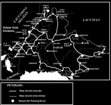
6 6 PPP INVOLVES TRANSFER TO THE PRIVATE SECTOR THE RESPONSIBILITY TO FUND AND MANAGE A CAPITAL INVESTMENT PACKAGE AND SERVICES INCLUDING THE CONSTRUCTION, MANAGEMENT, MAINTENANCE, IMPROVEMENT AND REPLACEMENT OF PUBLIC SECTOR ASSETS
7 1 FOR PPP PROJECTS, THE PRIVATE SECTOR INVOLVED WILL BE BOUND BY A CONTRACT AND IS REQUIRED TO PROVIDE LONG-TERM SERVICES, WHICH ARE PUBLIC INFRASTRUCTURE BASED 2 THE PRIVATE SECTOR WILL HAVE TO GENERATE ITS OWN FUNDS TO FINANCE THE WHOLE OR PART OF THE ASSETS AND HAVE TO PROVIDE SERVICES BASED ON AN AGREED LEVEL OF PERFORMANCE 3 THE GOVERNMENT, OR IN SOME CASES THE PUBLIC, WILL MAKE PAYMENTS TO THE PRIVATE SECTOR FOR THE SERVICES 7


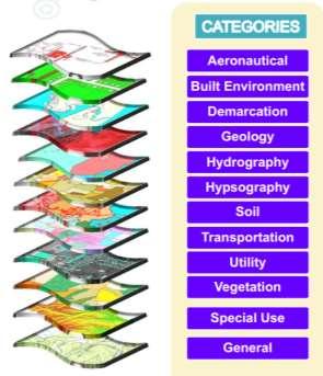
8 GEODETIC INFRASTRUCTURES BOUNDARY AFFAIRS CADASTRAL SURVEYS UNDERGROUND UTILITY MAPPING MAPPING GEOSPATIAL DEFENCE 8
9 1 LICENSED LAND SURVEYORS 2 GEOSPATIAL INDUSTRY PLAYERS 3 SURVEY EQUIPMENT SUPPLIERS 4 GIS VENDORS 9

10 POSITIONING BANDING 10 THE MALAYSIA REAL-TIME KINEMATIC GNSS NETWORK (MyRTKnet) AS IN 2016 NUMBER OF RTK STATIONS IN PENINSULAR MALAYSIA NUMBER OF RTK STATIONS IN SARAWAK NUMBER OF RTK STATIONS IN SABAH : 65 Stations : 15 Stations : 16 Stations TOTAL STATIONS 96 Stations


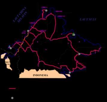
11 VERTICAL CONTROL Sarawak Sabah 11 Peninsular Malaysia
12 GEOID MODEL FOR MALAYSIA MyGEOID - EMGEOID05 (+-10cm) Klang Valley MyGEOID (+-1cm) MyGEOID - WMGEOID04 (+-5cm)


13 TIDE GAUGES Miri, Sarawak SABAH 6 Stations Note : SARAWAK 3 Stations PENINSULAR MALAYSIA 12 Stations STAPS equipped with Telemetry System (13 Stations) STAPS equipped with manual system and in the process to be upgraded with telemetry system by year 2017 (6 Stations) STAPS discontinued operations and will be reconstructed in 2018 (2 Stations) 13
 NDCDB USED AS FUNDAMENTAL DATASET FOR GEOSPATIAL ANALYSIS")
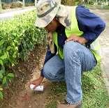
14 1 SURVEY OF CADASTRAL LOTS FOR TITLES BY LICENSED LAND SURVEYORS SURVEY DATA SUBMITTED TO JUPEM DIGITALLY CREATION OF NATIONAL DIGITAL CADASTRAL DATABASE (NDCDB) NDCDB USED AS FUNDAMENTAL DATASET FOR GEOSPATIAL ANALYSIS 14


15 15
16 Kuala Lumpur Putrajaya Coverage area = ± 300 sq km 16

17 WORKFLOW PROCESS Data Acquisition Data Management & Preparation Data Sharing & Dissemination 17
18 Data Acquisition: Multi-view Oblique Aerial Imagery LiDAR and Orthophoto Mobile Laser Scanning 360 Degree Panoramic Street View Imagery Terrestrial Laser Scanning Feature extraction Oblique Image Orthophoto DSM DTM Contour 18

19 Data Acquisition: Multi-view Oblique Aerial Imagery LiDAR and Orthophoto Mobile Laser Scanning 360 Degree Panoramic Street View Imagery Terrestrial Laser Scanning Feature extraction 19
20 Data Acquisition: Multi-view Oblique Aerial Imagery LiDAR and Orthophoto Mobile Laser Scanning 360 Degree Panoramic Street View Imagery Terrestrial Laser Scanning Feature extraction 20
21 2D Maps 3D Maps 2D Maps Kuala Lumpur Kuala Lumpur Putrajaya Putrajaya 21
22 2D Maps Apps Tools Map Catalogue Identify Print Line Measure (include bearings) Radius Measure Area Measure (include bearings) 22

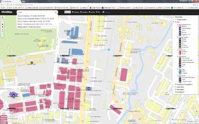
23 3D Maps Analysis 23
24 3D Maps- Apps Tools Overlay with Street Network Overlay with Cadastre Lot (NDCDB boundary, stones, line & CRM GNSS stone) 24

25 3D Maps- Apps Tools Terrain Profile 3D Viewshed 25
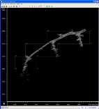
26 26
27 Digital Data BIM 3D Trends 27


28 Map Publishing Digital Aerial 1 Camera 2 Fieldwork Ground Control Points Field Data Collection 3 Editing (mono/stereo) 4 Topography Database Cartography Database 28


29 MAPPING PRODUCTS Topography Map 1: Topography Map 1: Thematic Map Non-Restricted map MY701A for Peninsular Malaysia and MY711A for Sabah/Sarawak Map series MY502A for Peninsular Malaysia and MY512A for Sabah/Sarawak Thematic Map series MY90005R and MY91005R (multiple scale) 29


30 1: scale DIGITAL DATA 1: scale Topographic Layers 30

31 31 Webmap and eatlas
32 ORTHOPHOTO SUPPLIED BY JUPEM MONO DIGITISING FIELD VERIFICATION DIGITAL TOPOGRAPHIC DATA CREATION OF NATIONAL TOPOGRAPHIC DATABASE 1:


33 WHOLE OF PENINSULAR MALAYSIA ORTHOPHOTO TWO (2) METERS ACCURACY DIGITAL TERRAIN MODEL TO BE USED FOR MAPPING, FLOOD MODELLING, SLOPE ANALYSIS AND ETC 33
 (Approximately Area by Index : 143,675 km 2 for MAP MY701 Series) VIEW 3D SAR DATA FOR KENYIR LAKE,")
34 AREA OF INTEREST (AOI) SYNTHETIC APERTURE RADAR DATA 3-DIMENSION DATA FOR MAINLAND AND ISLAND OF PENINSULAR MALAYSIA) (Approximately Area by Index : 143,675 km 2 for MAP MY701 Series) VIEW 3D SAR DATA FOR KENYIR LAKE, TERENGGANU 34


35 35 ALONG THE MAIN RIVERS IN THE STATE OF KELANTAN AND TERENGGANU
 0.")

36 ORTHOPHOTO DIGITAL SURFACE MODEL (DSM) 0.25 METER ACCURACY OF DIGITAL TERRAIN MODEL (DTM) FLOOD MODELLING 36
37 1 NEWLY LAID UNDERGROUND UTILITY INSTALLATION TO BE SURVEYED AS-BUILT BY LICENSED LAND SURVEYORS PLAN AND DIGITAL DATA SUBMITTED TO JUPEM 2 3 JUPEM UPDATE UNDERGROUND UTILITY DATABASE DATA USED FOR FUTURE UTILITY PROJECTS BY UTILITY AGENCIES AND CONTRACTORS 4 37


38 GPR PCL PREPARATION OF FIELDWORK INSTRUCTIONS RECONNAISSANCE WORKING AREA CONTROL SURVEY GPR FIELD DATA ACQUISITION DETECTION UNDERGROUND UPDATED INTO DATABASE DATA PROCESSING UTILITY DETAIL SURVEY AND BASE MAP INFORMATION DETECTION MARKING 38
39
40 W A Y F O R W A R D GEOSPATIAL DATA AS INFRASTRUCTURE IMPORTANCE OF GEOSPATIAL NBOS COLLABORATION PPP 40
41 41 THANK YOU
SPURRING NATION S ECONOMY THROUGH SmartKADASTER
 SPURRING NATION S ECONOMY THROUGH SmartKADASTER SR MOHAMAD KAMALI BIN ADIMIN DIVISION DIRECTOR (CADASTRE) DEPARTMENT OF SURVEY AND MAPPING MALAYSIA THE NEED TO TRANSFORM TRANSFORMATION AGENDA EMPOWERING
GEOMATICS. Shaping our world. A company of
 GEOMATICS Shaping our world A company of OUR EXPERTISE Geomatics Geomatics plays a mayor role in hydropower, land and water resources, urban development, transport & mobility, renewable energy, and infrastructure
Country Report On Sdi Activities In Singapore ( )
") UNITED NATIONS E/CONF.102/IP.4 ECONOMIC AND SOCIAL COUNCIL Nineteenth United Nations Regional Cartographic Conference for Asia and the Pacific Bangkok, 29 October 1 November 2012 Item 6(b) of the provisional
UNITED NATIONS E/CONF.102/IP.4 ECONOMIC AND SOCIAL COUNCIL Nineteenth United Nations Regional Cartographic Conference for Asia and the Pacific Bangkok, 29 October 1 November 2012 Item 6(b) of the provisional
HMK Swedish handbook in surveying and mapping
 HMK Swedish handbook in surveying and mapping A Alfredsson, J Sunna, C-G Persson TS07B - Standards and Recommended Practices for Positioning and Measurement, Paper no 7072 FIG Congress 2014 Engaging the
Mapping a Nation in 3D Singapore s Journey. Bryan Chew Registrar of Titles Assistant Chief Executive Singapore Land Authority
 Mapping a Nation in 3D Singapore s Journey Bryan Chew Registrar of Titles Assistant Chief Executive Singapore Land Authority Singapore Size - 719 sq km Population - 5.5 million Density 7,600/sq km Singapore
Country Report on SDI Activities in Singapore *
 UNITED NATIONS E/CONF.100/CRP.9 ECONOMIC AND SOCIAL COUNCIL Eighteenth United Nations Regional Cartographic Conference for Asia and the Pacific Bangkok, 26-29 October 2009 Item 7(a) of the provisional
Introduction. Elevation Data Strategy. Status and Next Steps
 1 2 Introduction Elevation Data Strategy Status and Next Steps 3 Canada is the 2nd largest country in the world - 9.9 million sq km Surrounded by 3 oceans with 202 000 km of coastline Population over 35
Sustainable and Harmonised Development for Smart Cities The Role of Geospatial Reference Data. Peter Creuzer
 Sustainable and Harmonised Development for Smart Cities The Role of Geospatial Reference Data Peter Creuzer 1. Introduction - Smart Cities and Geodata 2. Geodata in Germany 3. Examples 4. Data and Service
State of Israel Ministry of Housing and Construction Survey of Israel. The Hydrological project case
 State of Israel Ministry of Housing and Construction Survey of Israel The Hydrological project case Survey of Israel Content Introduction To the Survey of Israel The operation assumptions The main responsibilities
Preparation of Database for Urban Development
 Preparation of Database for Urban Development By PunyaP OLI, 1. Chairman, ERMC (P) Ltd., Kathmandu, Nepal. Email: punyaoli@ermcnepal.com 2. Coordinator, Himalayan College of Geomatic Engineering and Land
SLOPE HAZARD AND RISK MAPPING: A TECHNOLOGICAL PERSPECTIVE
 International Symposium on Multi-Hazard and Risk 2015 23-24 March 2015, UTM Kuala Lumpur SLOPE HAZARD AND RISK MAPPING: A TECHNOLOGICAL PERSPECTIVE Very high resolution DTM derived from LiDAR LiDAR Ortho
QUESTIONNAIRE THE CURRENT STATUS OF MAPPING IN THE WORLD
 QUESTIONNAIRE ON THE CURRENT STATUS OF MAPPING IN THE WORLD The questionnaire is intended to take stock of the current status of mapping in the world. The information collected will eventually be used
A Broad View of Geospatial Technology & Systems
 A Broad View of Geospatial Technology & Systems Pete Large Vice President, Trimble On the shoulders of giants 1 Since their time, our ability to generate geospatial information has grown exponentially
Large Scale Mapping Policy for the Province of Nova Scotia
 Large Scale Mapping Policy for the Province of Nova Scotia December, 2005 Version 1.0 TABLE OF CONTENTS PAGE BACKGROUND...3 POLICY...5 Policy 1.0 Large Scale Mapping Program...5 Policy 2.0 Service Offering...5
Integrating geography and statistics, but what about earth observation?
 Integrating geography and statistics, but what about earth observation? 8 0 0 y 2 2 3 0 9 x 6 3 9 1 9 n 1 8 3 7 3 9 7 2 2 4 8 8 7 8 4 7 5 Ola Nordbeck Senior Advisor Ola.nordbeck@spacecentre.no Bridging
SURVEYING Chapter 1 Introduction
 PHILADELPHIA UNIVERSITY Faculty of Engineering. Department of Civil Engineering. SURVEYING Chapter 1 Introduction Surveying : the art or science of measuring and representing natural and artificial features
Ramani Geosystems. Putting Africa On The Map. Authorized Resellers
 Ramani Geosystems Putting Africa On The Map Authorized Resellers Ramani Profile Started in 1999 Aerial, Land Surveying & Mapping Solutions + 10 Countries in the region + 80 Staff working in projects Asset
Manitoba s Elevation (LiDAR) & Imagery Datasets. Acquisition Plans & Opportunities for Collaboration
 & Imagery Datasets. Acquisition Plans & Opportunities for Collaboration") Manitoba s Elevation (LiDAR) & Imagery Datasets Acquisition Plans & Opportunities for Collaboration Manitoba Planning Conference May 2017 Presentation Outline Manitoba s Elevation (LiDAR) and Imagery Datasets
Manitoba s Elevation (LiDAR) & Imagery Datasets Acquisition Plans & Opportunities for Collaboration Manitoba Planning Conference May 2017 Presentation Outline Manitoba s Elevation (LiDAR) and Imagery Datasets
Philippines NSDI Foundation Data Program. Andrew Bashfield
 Philippines NSDI Foundation Data Program Andrew Bashfield 1 Overview Part 1: Building the NSDI Framework Part 2: Collecting Foundation Datasets 2 Building the NSDI Framework Background & NDSI Overview
BANGLADESH SURVEY OF BANGLADESH PREMISES
 BANGLADESH SURVEY OF BANGLADESH PREMISES Survey of Bangladesh (SOB) is the National Mapping organization of Bangladesh SOB is carrying out all Geodetic activities of Bangladesh SOB is responsible for taking
Flood Mapping Michael Durnin October 9 th
 Michael Durnin October 9 th 2014 Leading Surveyors Company Profile Est. 1983 Celebrating 30 Years in Business Six Offices in UK & Ireland Over 30 Specialised Survey Services ISO 9001:2008 Registered Over
European Spatial Data Research. EuroSDR. Prof. Dr. Ir. Joep Crompvoets. General Assembly CLGE Tirana 18 March
 EuroSDR Prof. Dr. Ir. Joep Crompvoets General Assembly CLGE - 2016 Tirana 18 March 2016 INTRODUCTORY QUESTIONS Who knows what is EuroSDR? Who does NOT know what is EuroSDR? Who is employed at mapping agencies?
Statewide Topographic Mapping Program
 Statewide Topographic Mapping Program February 28, 2018 www.dotd.la.gov Outline Purpose of the Statewide Topographic Mapping Program History Breakdown of R.S. 48:36 - Topographic Mapping Statewide Topographic
Building a National Data Repository
 Building a National Data Repository Mladen Stojic, Vice President - Geospatial 1/30/2013 2012 Intergraph Corporation 1 Information has meaning and gives power only when shared and distributed. Information,
Geodetic & Geospatial Infrastructure/Systems
 Geodetic & Geospatial Infrastructure/Systems 1. Geodetic System: Borneo Triangulation 1968 (BT68) 2. Geospatial System: Land and Survey Information System (LASIS) LAND AND SURVEY DEPARTMENT SARAWAK An
The Integrated Ge spatial Information Framework to the strengthening of NSDI, Mongolia
 Young Geospatial Professionals Summit 21 NOV 2018 The Integrated Ge spatial Information Framework to the strengthening of NSDI, Mongolia BAYARMAA ENKHTUR Geospatial information and technology department
Topographic Strategy National Topographic Office March 2015
 www.linz.govt.nz Topographic Strategy National Topographic Office March 2015 >> Foreword Topographic information is vital to understanding our country and its assets, and for supporting economic development.
Oman NSDI Business Values and Future Directions. Hassan Alawi Alghazali Acting Director General National Spatial Data Infrastructure
 Oman NSDI Business Values and Future Directions Hassan Alawi Alghazali Acting Director General National Spatial Data Infrastructure Presentation Outline Geospatial Maturity Current Challenges NCSI s Role
CLICK HERE TO KNOW MORE
 CLICK HERE TO KNOW MORE GENERALIZATION OF TOPOGRAPHIC DATABASE FOR SERVING GEOSPATIAL DATA FOR MILITARY AND SOCIO-ECONOMIC TASKS IN VIETNAM Speaker: Lieutenant Colonel, Nguyen Dinh Minh GENERAL STAFF -
UNITED NATIONS E/CONF.96/CRP. 5
 UNITED NATIONS E/CONF.96/CRP. 5 ECONOMIC AND SOCIAL COUNCIL Eighth United Nations Regional Cartographic Conference for the Americas New York, 27 June -1 July 2005 Item 5 of the provisional agenda* COUNTRY
Challenges and Potentials of Place Based Information Management in Nepal"
 Nineteenth United Nations Regional Cartographic Conference for Asia and the Pacific, Bangkok, Thailand, 29 October 1 November 2012 Challenges and Potentials of Place Based Information Management in Nepal"
THE ROLE OF GEOSPATIAL AT THE WORLD BANK
 THE ROLE OF GEOSPATIAL AT THE WORLD BANK INSPIRE Conference Barcelona, Spain September 26, 2016 Kathrine Kelm Senior Land Administration Specialist Global Land and Geospatial Unit The World Bank Group
Land Administration and Cadastre
 Geomatics play a major role in hydropower, land and water resources and other infrastructure projects. Lahmeyer International s (LI) worldwide projects require a wide range of approaches to the integration
GRINDING THE GEARS AND PUTTING THE RUBBER TO THE ROAD GEOSCIENCE AUSTRALIA S EXPERIENCE IN IMPLEMENTING THE FOUNDATION SPATIAL DATA FRAMEWORK
 GRINDING THE GEARS AND PUTTING THE RUBBER TO THE ROAD GEOSCIENCE AUSTRALIA S EXPERIENCE IN IMPLEMENTING THE FOUNDATION SPATIAL DATA FRAMEWORK Shane Crossman Geoscience Australia Shane.Crossman@ga.gov.au
COUNTRY REPORT ON CARTOGRAPHIC ACTIVITIES IN SINGAPORE ( ) Submitted by Singapore **
 Submitted by Singapore **") UNITED NATIONS E/CONF.97/5/CRP. 9 ECONOMIC AND SOCIAL COUNCIL Seventeenth United Nations Regional Cartographic Conference for Asia and the Pacific Bangkok, 18-22 September 2006 Item 6 (b) of the provisional
UNITED NATIONS E/CONF.97/5/CRP. 9 ECONOMIC AND SOCIAL COUNCIL Seventeenth United Nations Regional Cartographic Conference for Asia and the Pacific Bangkok, 18-22 September 2006 Item 6 (b) of the provisional
Innovation in mapping and photogrammetry at the Survey of Israel
 16, October, 2017 Innovation in mapping and photogrammetry at the Survey of Israel Yaron Felus and Ronen Regev Contents Why HD mapping? Government requirements Mapping regulations o Quality requirements
TERMS OF REFERENCE FOR PROVIDING THE CONSULTANCY SERVICES OF
 1 Cartographic Database and TM100 Product Specifications TERMS OF REFERENCE FOR PROVIDING THE CONSULTANCY SERVICES OF Production and establishment of cartographic database for scale 1:100,000 and production
Coordinate systems, measured surveys for BIM, total station for BIM, as-built surveys, setting-out
 Coordinate systems, measured surveys for BIM, total station for BIM, as-built surveys, setting-out What is a BIM What does a BIM do Why use a BIM BIM Software BIM and the Surveyor How do they relate to
Disaster Management & Recovery Framework: The Surveyors Response
 Disaster Management & Recovery Framework: The Surveyors Response Greg Scott Inter-Regional Advisor Global Geospatial Information Management United Nations Statistics Division Department of Economic and
ABSTRACT The first chapter Chapter two Chapter three Chapter four
 ABSTRACT The researches regarding this doctoral dissertation have been focused on the use of modern techniques and technologies of topography for the inventory and record keeping of land reclamation. The
GIS Geographical Information Systems. GIS Management
 GIS Geographical Information Systems GIS Management Difficulties on establishing a GIS Funding GIS Determining Project Standards Data Gathering Map Development Recruiting GIS Professionals Educating Staff
Ministry of ICT of I.R.IRAN
 The ECO 8/6 mill km 2 10 Slamic countries ~330 mill people Oil, Gas, Industries,Tourism 2 Issue transformation in last decade Problem solving needs more integrated approach More interaction &complexity
Imagery and the Location-enabled Platform in State and Local Government
 Imagery and the Location-enabled Platform in State and Local Government Fred Limp, Director, CAST Jim Farley, Vice President, Leica Geosystems Oracle Spatial Users Group Denver, March 10, 2005 TM TM Discussion
Department of Statistics Malaysia
 Department of Statistics Malaysia 1 2 1 2 3 4 5 Introduction Geographic Information Systems (GIS) Geospatial activities for 2020 Modernisation Way Forward 3 Malaysia Population (Millions) Census 2010 2018
"GIS-Sofia" Ltd. geospatial data integration in SOFCAR geographic information system and providing services March 2018, Sofia
 "GIS-Sofia" Ltd. geospatial data integration in SOFCAR geographic information system and providing services Geographical Information System Sofia " Ltd....the beginning... Established in 1999, as a Sofia
Background Document: Report of the Regional Committee of United Nations Global Geospatial Information Management for Asia and the Pacific
 Background Document: Report of the Regional Committee of United Nations Global Geospatial Information Management for Asia and the Pacific 1. Summary 1. This report highlights the activities carried out
USGS Hydrography Overview. May 9, 2018
 + 1 USGS Hydrography Overview May 9, 2018 + 2 The National Geospatial Program Provides the geospatial baseline of the Nation s topography, natural landscape and built environment through The National Map,
Part : General Situation of Surveying and Mapping. The Development of Surveying and Mapping in China. The contents
 The Development of Surveying and Mapping in China Dr. Ping Xiao China.P.R The contents Part : General Situation of Surveying and Mapping 1. The legal systems of surveying and mapping 2. The technologies
GIS FOR MAZOWSZE REGION - GENERAL OUTLINE
 GIS FOR MAZOWSZE REGION - GENERAL OUTLINE S. Bialousz 1), K Mączewski 2), E. Janczar 2), K. Osinska-Skotak 1) 1) Warsaw University of Technology, Warsaw, Poland 2) Office of the Surveyor of the Mazowieckie
DATA DEVELOPMENT IN BRUNEI DARUSSALAM. Submitted by Survey Department, Brunei Darussalam **
 UNITED NATIONS E/CONF.97/6/IP. 45 ECONOMIC AND SOCIAL COUNCIL Seventeenth United Nations Regional Cartographic Conference for Asia and the Pacific Bangkok, 18-22 September 2006 Item 7 of the provisional
Exploring GIS Potential for Northwestern Ontario Land Information Ontario
 Exploring GIS Potential for Northwestern Ontario Land Information Ontario May 13, 2015 The LIO Vision LIO Vision: That all geographic information about Ontario is fully integrated and accessible LIO Goal:
Business Model for sustainable regional development by tourism
 Business Model for sustainable regional development by tourism Why EuroVeloPark Banat? Steps to Success Action proposal 1. Drawing of the Basis Map 2. Data Acquisition, POIs, etc. 3. Printed Map and Distribution
The project, born from an idea of the Provincial College of the Surveyors of Trapani and from the synergy between the administration of Mazara del
 The project, born from an idea of the Provincial College of the Surveyors of Trapani and from the synergy between the administration of Mazara del Vallo, with the Surveyors Professional Organizations :
Gis for Land Management: An Overview on Italy
 Gis for Land Management: An Overview on Italy Paola RONZINO, Italy Key words: Cartography, Land Management, Spatial Planning, Urban Renewal, Spatial Information, Environment SUMMARY The introduction of
EuroSDR (European Spatial Data Research)
") EuroSDR (European Spatial Data Research) ROLLING RESEARCH PLAN 2015-2018 EuroSDR Secretariat Public Governance Institute KU Leuven Parkstraat 45 bus 3609 3000 Leuven Belgium Tel.: +32 16 32 31 80 Fax:
EuroSDR (European Spatial Data Research) ROLLING RESEARCH PLAN 2015-2018 EuroSDR Secretariat Public Governance Institute KU Leuven Parkstraat 45 bus 3609 3000 Leuven Belgium Tel.: +32 16 32 31 80 Fax:
Voices from Private Sector: Insights for Future NSDI Development in Indonesia
 Voices from Private Sector: Insights for Future NSDI Development in Indonesia Ta n d a n g Yu l i a d i D w i P u t ra, Ryosuke S h i b a s a k i I n st i t u t e o f I n d u st r i a l S c i e n c e,
Basics of GIS reviewed
 Basics of GIS reviewed Martin Breunig Karlsruhe Institute of Technology martin.breunig@kit.edu GEODETIC INSTITUTE, DEPARTMENT OF CIVIL ENGINEERING, GEO AND ENVIRONMENTAL SCIENCES, CHAIR IN GEOINFORMATICS
An Industry Perspective. Bryn Fosburgh Vice President Trimble
 An Industry Perspective Bryn Fosburgh Vice President Trimble Who are we? Professionals & Consultants Geospatial Professionals working at or with: AEC Consultants Transportation Departments Construction
Norwegian spatial data infrastructure supporting disaster risk management Norwegian Mapping Authority
 Norwegian spatial data infrastructure supporting disaster risk management Norwegian Mapping Authority Arvid Lillethun, Norwegian Mapping Authority Land and Poverty 2018 Conference, World Bank 19.-23. March
ICSM delivering benefits through collaboration
 ICSM delivering benefits through collaboration Russell Priebbenow Chair and Queensland Member Australia and New Zealand s Intergovernmental Committee on Surveying and Mapping Overview Who is ICSM & why
Summary of Presentation:
 Development of Geodetic GPS Infrastructure and Its : The Malaysia Experience BY Abd Majid.A.Kadir, Shahrum Ses, Kamaluddin Omar & Abdullah Hisam Omar Fac. of Geoinformation Science and Eng. Universiti
SDI DEVELOPMENT UPDATES OF INDONESIA
 SDI DEVELOPMENT UPDATES OF INDONESIA DR. ANTONIUS B. WIJANARTO Center For Management And Dissemination Of Geospatial Information GEOSPATIAL INFORMATION AUTHORITY GOVERNMENT OF THE REPUBLIC OF INDONESIA
THE CADASTRAL INFORMATION SYSTEM IN THE REPUBLIC OP SOUTH AFRICA
 I $:? Distr.: LIMITED ECA/NRD/CART.9/ORG.27 November 1996 Original: ENGLISH Ninth United Nations Regional Cartographic Conference for Africa Addis Ababa, Ethiopia 11-15 November 1996 THE CADASTRAL INFORMATION
16540/14 EE/cm 1 DG E 1A
 Council of the European Union Brussels, 5 December 2014 (OR. en) 16540/14 ENV 965 CULT 139 NOTE From: To: Subject: General Secretariat of the Council Delegations Charter of Rome on Natural and Cultural
Esri Image & Mapping Forum 9 July 2017 Geiger-Mode for Conservation Planning & Design by USDA NRCS NGCE
 Esri Image & Mapping Forum 9 July 2017 Geiger-Mode for Conservation Planning & Design by USDA NRCS NGCE For over 75 years, the Natural Resources Conservation Service has been a pioneer in conservation,
The Swedish National Geodata Strategy and the Geodata Project
 The Swedish National Geodata Strategy and the Geodata Project Ewa Rannestig, Head of NSDI Co-ordination Unit, Lantmäteriet, ewa.rannstig@lm.se Ulf Sandgren, Project Manager Geodata Project, Lantmäteriet,
Maanmittauspäivät 2018 Helsinki Maanmittauspäivät 2018 The Danish initiatives regarding open and free basic data including effect studies
 Maanmittauspäivät 2018 The Danish initiatives regarding open and free basic data including effect studies 22.03.2018 Agenda 1. Intro overall frame / selfie 2. Data Infrastructure 3. The Danish Digital
Emergency Planning. for the. Democratic National. Convention. imaging notes // Spring 2009 //
 Emergency Planning for the Democratic National Convention The DRAPP Demonstrates Partnership among Local, Regional, State, Utility and Federal Governments 14 imaging notes // Spring 2009 // www.imagingnotes.com
Asset Management Planning. GIS and Asset Management Integration Readiness Assessment
 Asset Management Planning GIS and Asset Management Integration Readiness Assessment With too little data, you won t be able to make any conclusions that you trust. With loads of data you will find relationships
The Road to Data in Baltimore
 Creating a parcel level database from high resolution imagery By Austin Troy and Weiqi Zhou University of Vermont, Rubenstein School of Natural Resources State and local planning agencies are increasingly
Integrating LiDAR data into the workflow of cartographic representation.
 Integrating LiDAR data into the workflow of cartographic representation. Cartographic Workflow I. 1 2 3 4 5 Surveying Vector (Nat. GDB) GPS, Laser Range Finder Yes/ No Scanning old maps LiDARflights Capture
Regional GIS Initiatives Geospatial Technology Center
 Regional GIS Initiatives Geospatial Technology Center Mr. Bobby Lear GIS Coordinator St. James Parish & Dr. Balaji Ramachandran Contractors Educational Trust Fund Endowed Professor Geomatics Program, Department
Data Aggregation with InfraWorks and ArcGIS for Visualization, Analysis, and Planning
 Data Aggregation with InfraWorks and ArcGIS for Visualization, Analysis, and Planning Stephen Brockwell President, Brockwell IT Consulting, Inc. Join the conversation #AU2017 KEYWORD Class Summary Silos
ESRI GIS For Mining Seminar, 10 th August, 2016, Nairobi, Kenya. Spatial DATA Solutions for Mining
 ESRI GIS For Mining Seminar, 10 th August, 2016, Nairobi, Kenya Spatial DATA Solutions for Mining Spatial Data Solutions for Mining Spatial - Data that identifies the geographic location of features &
GEOMATICS SURVEYING AND MAPPING EXPERTS FOR OVER 35 YEARS
 GEOMATICS SURVEYING AND MAPPING EXPERTS FOR OVER 35 YEARS 2 GEOMATICS AND SURVEYING SOLUTIONS SPANNING THE ENTIRE PROJECT LIFECYCLE 1,000+ 250+ 24 Surveying professionals Active field crews Geomatics offices
Leveraging Geospatial Technology for Cadastral Surveys
 Matthew Delano, LS Geospatial World Forum January 2017 Leveraging Geospatial Technology for Cadastral Surveys Fit-for-Purpose Simple to start Can improve over time whenever necessary Meet the needs of
VISUALIZING THE SMART CITY 3D SPATIAL INFRASTRUCTURE GEOSMART ASIA- 30 SEP, 2015
 www.aamgroup.com VISUALIZING THE SMART CITY 3D SPATIAL INFRASTRUCTURE GEOSMART ASIA- 30 SEP, 2015 Agenda AAM What is a Smart City? Data Acquisition 3D Modelling Benefits Questions AAM AAM is a Geospatial
Japan Construction Information Center
 Japan Construction Information Center A Framework for Data Coordination Method of Maintenance Data and 3D Conceptual Model on CIM Based Database July 2016 Japan Construction Information Center Foundation
National Geographic Institute (IGN)
") (IGN) National Centre of Geographic Information (CNIG) Tenth United Nations Regional Cartographic Conference of the Americas New York, 19-23 August 2013 Spanish National Land Observation Program (PNOT)
(IGN) National Centre of Geographic Information (CNIG) Tenth United Nations Regional Cartographic Conference of the Americas New York, 19-23 August 2013 Spanish National Land Observation Program (PNOT)
Current experiences in the use of satellite information in development aid activities
 Current experiences in the use of satellite information in development aid activities Meeting at ESA/ESRIN in Frascati 16 th of September 2017 #WorldInCommon AGENCE FRANÇAISE DE DÉVELOPPEMENT FRENCH DEVELOPMENT
USING GIS CARTOGRAPHIC MODELING TO ANALYSIS SPATIAL DISTRIBUTION OF LANDSLIDE SENSITIVE AREAS IN YANGMINGSHAN NATIONAL PARK, TAIWAN
 CO-145 USING GIS CARTOGRAPHIC MODELING TO ANALYSIS SPATIAL DISTRIBUTION OF LANDSLIDE SENSITIVE AREAS IN YANGMINGSHAN NATIONAL PARK, TAIWAN DING Y.C. Chinese Culture University., TAIPEI, TAIWAN, PROVINCE
Tracy Fuller U. S. Geological Survey. February 24, 2016
 U. S. Geological Survey Arctic Elevation Data Involvement Statewide Alaska IfSAR Radar Collection Program Pan-Arctic Digital Elevation Map International Coordination Tracy Fuller U. S. Geological Survey
FIRE DEPARMENT SANTA CLARA COUNTY
 DEFINITION FIRE DEPARMENT SANTA CLARA COUNTY GEOGRAPHIC INFORMATION SYSTEM (GIS) ANALYST Under the direction of the Information Technology Officer, the GIS Analyst provides geo-spatial strategic planning,
Empowering water/wastewater network management with GIS
 Empowering water/wastewater network management with GIS Ioannis Kavouras_GIS Manager Surveying Engineer, MSc, MBA The Company responsible for fresh water distribution & sanitation serving 1.500.000 citizens
THE LAW OF THE REPUBLIC OF TAJIKISTAN ON GEODESY AND CARTOGRAPHY
 THE LAW OF THE REPUBLIC OF TAJIKISTAN ON GEODESY AND CARTOGRAPHY The given Law determines the legal basics of the activity in the sphere of geodesy and cartography, and it is aimed at creation of conditions
Technical Drafting, Geographic Information Systems and Computer- Based Cartography
 Technical Drafting, Geographic Information Systems and Computer- Based Cartography Project-Specific and Regional Resource Mapping Services Geographic Information Systems - Spatial Analysis Terrestrial
Exploring the boundaries of your built and natural world. Geomatics
 Exploring the boundaries of your built and natural world Geomatics Before the Luxor brought magic to the Las Vegas strip and before the South LRT extension in Edmonton gave residents a new route to travel,
GIS = Geographic Information Systems;
 What is GIS GIS = Geographic Information Systems; What Information are we talking about? Information about anything that has a place (e.g. locations of features, address of people) on Earth s surface,
Geospatial Policy Development and Institutional Arrangements *
 HIGH LEVEL FORUM ON GLOBAL GEOSPATIAL MANAGEMENT INFORMATION WORKING PAPER No. 13 First Forum Seoul, Republic of Korea, 24-26 October 2011 Geospatial Policy Development and Institutional Arrangements *
TTV VÉÇáâÄà Çz TTV VÉÇáâÄà Çz. TTV (LAGIS) VÉÇáâÄà Çz. TTV VÉÇáâÄà Çz. TTV VÉÇáâÄà Çz. TTV VÉÇáâÄà Çz. TTV VÉÇáâÄà Çz. TTV VÉÇáâÄà Çz.
 VÉÇáâÄà Çz. TTV VÉÇáâÄà Çz. TTV VÉÇáâÄà Çz. TTV VÉÇáâÄà Çz. TTV VÉÇáâÄà Çz. TTV VÉÇáâÄà Çz.") (LAGIS) by ANTHONY A. ADEOYE, Nigeria AAC Consulting, Lagos Lagos State Geoinformation Infrastructure Policy As a Tool for Mega City Development: Opportunities and Challenges aacogis@yahoo.com 1.0 INTRODUCTION
(LAGIS) by ANTHONY A. ADEOYE, Nigeria AAC Consulting, Lagos Lagos State Geoinformation Infrastructure Policy As a Tool for Mega City Development: Opportunities and Challenges aacogis@yahoo.com 1.0 INTRODUCTION
Syllabus Reminders. Geographic Information Systems. Components of GIS. Lecture 1 Outline. Lecture 1 Introduction to Geographic Information Systems
 Syllabus Reminders Geographic Information s Lecture Introduction to Geographic Information s. Class Info: www.saigis.com/class/ 2. Office T / TH (8:00-9:30 a.m.) and (2:30 3:30pm) or Appt 3. Email: burgerpr@unk.edu
2006 GIS-T T Symposium Columbus Ohio
 2006 GIS-T T Symposium Columbus Ohio Creating a Location Based Response System Using ESRI Technology Brian Stevens, CP Woolpert, Inc. Agenda Introduction What is LBRS? History Specifications Proposed Method
Visualisation of Digital Landscapes as a Potential Instrument for Visual Landscape Resource Management in the Maltese Islands
 Visualisation of Digital Landscapes as a Potential Instrument for Visual Landscape Resource Management in the Maltese Islands International Conference ECOLOGICAL LANDSCAPE MODELLING and MANAGEMENT FOR
Upgrade the Datasets in NSDI for Smarter Services with the Cases of China
 Upgrade the Datasets in NSDI for Smarter Services with the Cases of China By Dr. JIANG Jie Dept of GeoInformaiton Service Platform National Geomatics Center of China October 7, 2015 Jeju, Republic of Korea
ESRI Survey Summit August Clint Brown Director of ESRI Software Products
 ESRI Survey Summit August 2006 Clint Brown Director of ESRI Software Products Cadastral Fabric How does Cadastral fit with Survey? Surveyors process raw field observations Survey measurements define high-order
Geographic information for Strasbourg : from historical land register to 3D GIS city modelling 09/07/2017
 Geographic information for Strasbourg : from historical land register to 3D GIS city modelling 09/07/2017 Table of contents 1. Introduction of Strasbourg 2. A century of land surveying and cadastre 3.
COUNTY SPATIAL DATA INFRASTRUCTURE PRESENTATION: BY: GEOFREY CHERUIYOT NAIROBI CITY COUNTY
 . COUNTY SPATIAL DATA INFRASTRUCTURE PRESENTATION: BY: GEOFREY CHERUIYOT NAIROBI CITY COUNTY FRAMEWORK FOR AN INTEGRATED SPATIAL DATA INFRASTRUCTURE County GIS GIS : A computer based information system
UN COMMITTEE OF EXPERTSON GLOBAL GEOSPATIAL INFORMATION MANAGEMENT. August 13 15, 2012 COUNTRY REPORT OF THE PHILIPPINES
 UN COMMITTEE OF EXPERTSON GLOBAL GEOSPATIAL INFORMATION MANAGEMENT August 13 15, 2012 COUNTRY REPORT OF THE PHILIPPINES National Mapping and Resource Information Authority Department of Environment and
Geodesy. orientation. shape. gravity field
 Geodesy noun Science of measuring the shape, orientation and gravity field of the Earth and how it changes over time. shape orientation gravity field Positioning has always been important Downstream applications
Fugro Geospatial: Turning Spatial Data into Knowledge
 Fugro Geospatial: Turning Spatial Data into Knowledge 2016 Fugro Geospatial, GIS and Consultants Locations Variety of Collection Platforms Traditional Mapping Traditional Mapping Imagery Photogrammetric