SDI DEVELOPMENT UPDATES OF INDONESIA
|
|
|
- Eric Butler
- 6 years ago
- Views:
Transcription


1 SDI DEVELOPMENT UPDATES OF INDONESIA DR. ANTONIUS B. WIJANARTO Center For Management And Dissemination Of Geospatial Information GEOSPATIAL INFORMATION AUTHORITY GOVERNMENT OF THE REPUBLIC OF INDONESIA

2 INDONESIAN ACT 4 YEAR 2011 TRANSFORMATION IN PARADIGM AND INSTITUTION BAKOSURTANAL INSTITUTIONS OF NATIONAL ADVISER IN DEVELOPMENT OF SURVEY, MAPPING, AND SPATIAL DATA INFRASTRUCTURE GEOSPATIAL INFORMATION AGENCY THE NATIONAL ORGANIZER IN THE FIELD OF THE TOPOGRAPHIC SURVEY AND D BASE MAPPING INSTITUTIONS OF NATIONAL ADVISER IN DEVELOPMENT OF THEMATIC MAPS THE NATIONAL ORGANIZER FOR SPATIAL DATA INFRASTRUCTURE UN GGIM INDONESIA S UN GGIM INDONESIA S SDI UPDATE SDI GEOSPATIAL UPDATE GEOSPATIAL INFORMATION INFORMATION AGENCY OF INDONESIA AUTHORITY Page 2


3 ACT NO. 4 YEAR 2011 FOUNDATION FOR POLICY ON GEOSPATIAL INFORMATION GEOSPATIAL INFORMATION AUTHORITY (PREVIOUSLY BAKOSURTANAL)


4 ONE MAP ONE NATION POLICY: OUTSTANDING SUPPORTS FROM OUR LEADER President S.B. Yudoyono...Geospatial data are needed by all government institutions and communities to improve quality of decisions making in all aspects of national developments.


5 GEOSPATIAL INFORMATION ROLE TOWARDS SUSTAINABLE DEVELOPMENT DECENTRALIZATION AND REGIONAL AUTONOMY DATABASE GEOSPATIAL INFORMATION STATISTICS/ CENSUS PLANNING FOUNDATION SPATIAL PLANNING CADASTER MANAGEMENT APPROACH BY ZONE FAST GROWING BOUNDARY/ FRONTIER LEAST DEVELOPED DISASTER RISK SOCIAL CONFLICT URBAN SYSTEM RURAL LOCAL ECONOMIC DEVELOPMENT TRANSMIGRATION ISLANDS AND PROVINCIAL PLANNING DIRECTIVE NATIONAL GOALS UTILIZED BY ALL FOR ALL INTER REGION GAP REDUCTION COLLABORATIVE MANAGEMENT COORDINATION AND COLLABORATION BY ALL COORDINATED ACQUISITION PROSPERITY ACCELERATION INCREASING INCREASING INCREASING PRODUCT PRODUCT PRODUCT AND AND AND STRATEGIC STRATEGIC STRATEGIC VALUE VALUE VALUE INCREASING INCREASING INCREASING VALUE VALUE VALUE AND AND AND VOLUME VOLUME VOLUME OF OF OF DATA DATA DATA


6 STATUS 2013: BASE MAPPING BASEMAP


7 STATUS 2013: INDONESIAN GEODETIC REFERENCE SYSTEM CORS GPS DISTRIBUTION 2013 GRAVITY SURVEY COVERAGE 2013 SINGLE GEOREFERENCE SYSTEM FOR GEOSPATIAL INFORMATION INTEGRITY AND USEFULNESS
8 STATUS 2013: THEMATIC MAPPING Risk Map BMKG, PU, BIG, ESDM Sectoral Zonation Permit Map BPN, KEMENHUT, ESDM Land Cover map BIG, KEMENHUT, LH, LAPAN Earthquake Distribution Map ESDM, BMKG Ortho High Resolution Imagery BIG, LAPAN SECTORAL COORDINATION AND SINERGY FOR ONE MAP POLICY 11 NATIONAL WORKING GROUP FOR THEMATIC MAPPING NATURAL RESOURCE AND WATERSHED FARMING AND PEATLAND RESOURCE DYNAMIC CLIMATE CHANGE ECOREGION TRANSPORTATION DISASTER STUDY SPATIAL PLANNING MARINE RESOURCES, COASTAL, AND SMALL ISLANDS SOCIAL, ECONOMY,CULTURE AND ATLAS SECTORAL ZONATION, LAND COVER, AND LAND STATUS


9 STATUS 2013: SDI DEVELOPMENT Desktop View,Editing & Analizing Produk Peta & Data Portal Aplikasi GEOSPATIAL CLOUD COMPUTING NATIONAL DATA CENTER Web Services NATIONAL GEOPORTAL Survei Lapangan & Mobile Map Sistim Penyelenggaraan IG BIG : 1. Data Collection & Processing 2. Data Management 3. Geodatabase Management 4. Production Management 5. Publication Management 6. Utilizing


10 TOWARDS STRONG GEOSPATIAL INDUSTRY NATIONAL MAPPING AGENCY MIN. OF LABOR AND TRANSMIGRATION ACCREDITATION NATIONAL COMPETENCE STANDARD INDEPENDENT INSTITUTION CERTIFICATION LICENSING LICENSING Min. of Labor Decree No. 8/2012 PROFESSIONALS COMPANIES TRAINING INSTITUTIONS
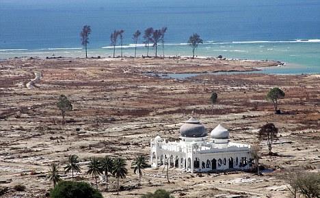
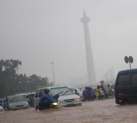
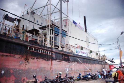
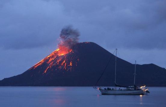
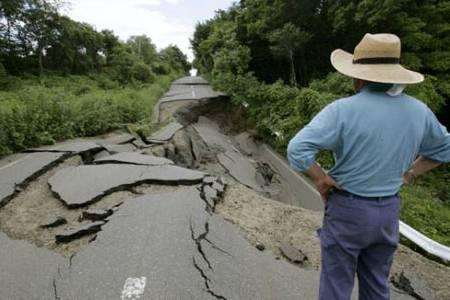

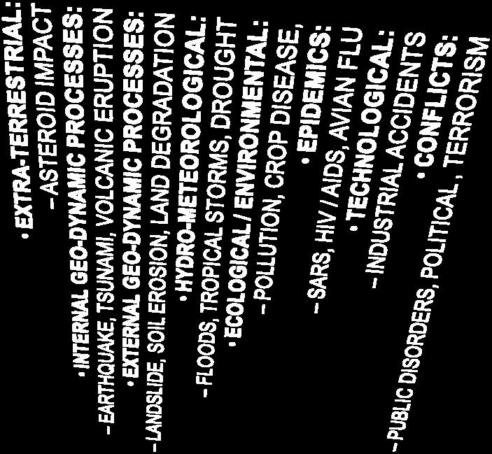
11 INDONESIA: FACING MOST KINDS OF HAZARDS VOLCANO ERUPTION EARTHQUAKE ARTIFICIAL FAILURE FLOOD TSUNAMI FOREST FIRE
12 KEY INSTITUTIONS IN DISASTER MANAGEMENT BNPB is the Indonesian National Board for Disaster Management : planning and coordinating the implementation of disaster management and emergency response activities in an integrated manner; and implement disaster management and emergency response from before, during, and after including disaster prevention, preparedness, emergency response, and recovery. BIG is the Geospatial Information Authority: planning, organizing and coordinating the development of geospatial information for disaster management activities.
13 POLICY FOUNDATION OF GEOSPATIAL INFORMATION FOR DISASTER MANAGEMENT INDONESIAN ACT 4 YEAR 2011 ABOUT GEOSPATIAL INFORMATION Article 17 In the event of natural disasters, war, change of administrative boundaries, or other events that result in changes in the basic map elements that influencing the pattern and structure of community life, updating basemap must be performed. Article 52 To the needs of disaster management, everyone shall share their geospatial information when requested by Government Agencies or local government given the task of disaster management affairs.


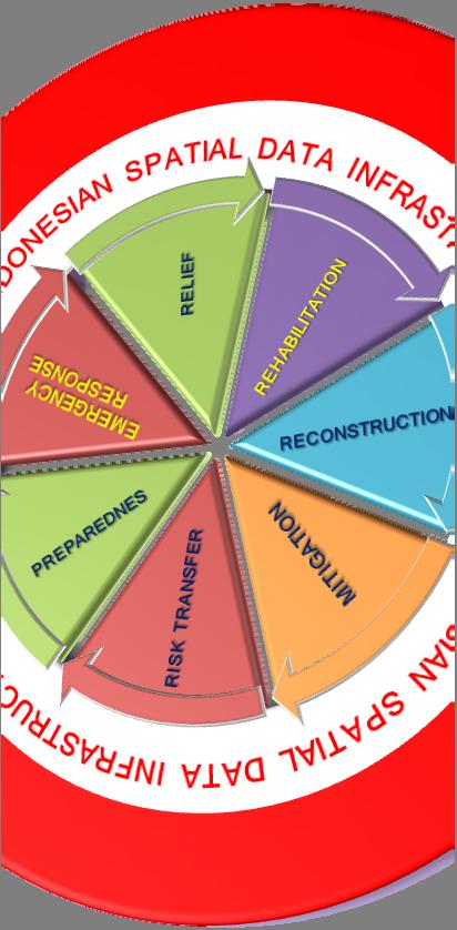


14 SDI ROLE IN DISASTER MANAGEMENT UN GGIM INDONESIA S SDI UPDATE GEOSPATIAL INFORMATION AUTHORITY Page 14


15 PILLARS of INA SDI FOR DISASTER MANAGEMENT UTILIZED BY ALL COLLABORATIVE MANAGEMENT COORDINATED ACQUISITION INCREASING INCREASING INCREASING PRODUCT PRODUCT PRODUCT AND AND AND STRATEGIC STRATEGIC STRATEGIC VALUE VALUE VALUE INCREASING INCREASING INCREASING VALUE VALUE VALUE AND AND AND VOLUME VOLUME VOLUME OF OF OF DATA DATA DATA Institutional Arrangement Human Resource Standardized Geospatial Data Science and Technology Laws And Rules UN GGIM INDONESIA S SDI UPDATE GEOSPATIAL INFORMATION AUTHORITY Page 15
16 SDI S WORKING ELEMENTS FOR DISASTER MANAGEMENT Acquisition Management Visualization Access Integration Analisys Quality Control Quality Assurance CONTRIBUTORS GOVERNMENTS PRIVATE AND VENDORS INTEROPABILITY GUIDANCE AND SPECIFICATION SDI ARRANGEMENT STANDARD ONE MAP POLICY GEOSPATIAL INFORMATION METADATA INSTITUTIONAL ARRANGEMENT Accuracy Availability Coverage Completeness others DATA SCALE AND RESOLUTION METADATA COMMUNITIES ACCESS POLICY IMPLEMENTATION OF STANDARD DATA MANAGEMENT HUMAN RESOURCES CERTIFIED PROFESSIONALS ACADEMICS SDI COMMITTEE GEOPORTAL GEO-ICT CAPACITY BUILDING HARDWARE AND NETWARE DATA ACQUISITION ACCESS DAN ANALYSIS TYPE OF DATA WELL-INFORMED DECISION MAKERS SOFTWARE DATABASE MANAGEMENT SYSTEM UN GGIM INDONESIA S SDI UPDATE GEOSPATIAL INFORMATION AUTHORITY Page 16


17 ARCHITECTURE OF INA SDI: READINESS FOR DISASTER EVENT MINISTRIES, PROVINCES, MUNICIPALITIES, AND THE COMMUNITIES MUNICIPAL NATIONAL GEOSPATIAL INFORMATION AUTHORITY CUSTODIAN CUSTODIAN MUNICIPAL DATA CENTER METADATA CATALOG PORTAL CLEARING HOUSE UNIT NATIONAL GEOPORTAL NATIONAL DATA CENTER CLEARINGHOUSE UNIT METADATA CATALOG PORTAL DISASTER MANAGEMENT AGENCY CUSTODIAN BUREAU UNIT OFFICE OTHER MINISTIRES CLEARINGHOUSE UNIT METADATA CATALOG PORTAL OTHER LOCAL GOVT CLEARINGHOUSE UNIT METADATA CATALOG PORTAL CLEARINGHOUSE UNIT NATIONAL DATA CENTER METADATA CATALOG PORTAL

18 INA GEOPORTAL : ONE MAP ONE GATEWAY OR sdi.or.id
19 WEB APP FOR DISASTER MANAGEMENT STATISTICAL GEOSPATIAL INTEGRATION ON INA GEOPORTAL PLATFORM FACILITATING ALL LEVEL OF DECISION MAKINGS TO COLLABORATE FOR DISASTER RESPONSES WITH ACCURATE AND ACCOUNTABLE GEOSPATIAL INFORMATION UN GGIM INDONESIA S SDI UPDATE GEOSPATIAL INFORMATION AGENCY OF INDONESIA Page 19

20 INA GEOPORTAL : SERVICING BASEMAPS TO MEMBER OF INA SDI AND THE COMMUNITIES
21 GEOSPATIAL SUPPORT COMMAND CENTER BETTER DECISION MAKING WITH COMMON OPERATING MAPS ANALYZING VISUALIZING PLANNING GEO ACCOUNTING GEOSPATIAL SUPERIORITY MAPPING GEO MONITORING ACTING DECISION MAKING NATIONAL GEOSPATIAL INFORMATION AUTHORITY LOCAL GOVERNMENT INDONESIAN SDI COMMUNITIES MINISTRIES ARMED FORCES/POLICE CAPABILIT GOVERNANCE Y IN THE FIELDS OF SURVEYING, MAPPING AND GEOSPATIAL DATA INFRASTRUCTURE IN PROVIDING TIMELY, RELEVANT, AND ACCURATE GEOSPATIAL INFORMATION TO SUPPORT DISASTER MANAGEMENT
 IMPLEMENTING OPEN GOVERNMENT DATA AS PART OF")

22 WAY FORWARD COMPLETE NATIONAL BASEMAPS AND HIGH RESOLUTION ORTHO IMAGERY. IMPROVING STABLE NETWORK INFRASTRUCTURE (IN COORDINATION WITH THE MINISTRY OF COMMUNICATION AND INFORMATION) IMPLEMENTING OPEN GOVERNMENT DATA AS PART OF OPEN GOVERNMENT INITITATIVE CONSTRUCT NEW POLICY AND GUIDELINES TO ENCOURAGE MORE STATE MINISTRIES, PROVINCIAL AND LOCAL GOVERNMENTS, AND UNIVERSITIES TO JOIN SDI. SYNCHRONIZE WITH REGIONAL AND GLOBAL POLICY ON GEOSPATIAL INFORMATION, ESPECIALLY FOR COMPLETION OF AND AFTERMATH MILLENIUM DEVELOPMENT GOALS. UN GGIM INDONESIA S SDI UPDATE GEOSPATIAL INFORMATION AGENCY OF INDONESIA Page 22


23 SEE YOU IN BALI FOR UN GGIM GGIM AP PLENNARY MEETING 2014 Terima Kasih/Thank You/
The Role Of Ina-SDI For Disaster Management
 The Second UN-GGIM-AP Plenary Meeting The Role Of Ina-SDI For Disaster Management Indonesia Tehran - Iran 28 October 2013 Dodi Sukmayadi Geospatial Information Authority of Indonesia (BIG) COMPONENT FOR
INDONESIA S S UPDATE: GEOSPATIAL INFORMATION FOR SUSTAINABLE DEVELOPMENT RELATED TO INA SDI Dr. Asep Karsidi, M.Sc
 INDONESIA S S UPDATE: GEOSPATIAL INFORMATION FOR SUSTAINABLE DEVELOPMENT RELATED TO INA SDI Dr. Asep Karsidi, M.Sc GEOSPATIAL INFORMATION AGENCY 08 August, 2012 OUTLINE 1. Transformation Bakosurtanal into
Strengthening Geospatial Information Management in Indonesia
 b Strengthening Geospatial Information Management in Indonesia Prof. Dr. Hasanuddin Z. Abidin Head (President) Geospatial Information Agency of Indonesia The 5 th High Level Forum United Nations Global
Development of Geospatial Information in Indonesia: Progress & Challenge
 Development of Geospatial Information in Indonesia: Progress & Challenge Dr. Nurwadjedi Sarbini Deputy of Thematic Geospatial Information Geospatial Information Agency (BIG) Geosmart Asia, September 29
Voices from Private Sector: Insights for Future NSDI Development in Indonesia
 Voices from Private Sector: Insights for Future NSDI Development in Indonesia Ta n d a n g Yu l i a d i D w i P u t ra, Ryosuke S h i b a s a k i I n st i t u t e o f I n d u st r i a l S c i e n c e,
Report of the Working Group 2 Data Sharing and Integration for Disaster Management *
 UNITED NATIONS E/CONF.104/6 ECONOMIC AND SOCIAL COUNCIL Twentieth United Nations Regional Cartographic Conference for Asia and the Pacific Jeju, 6-9 October 2015 Item 5 of the provisional agenda Report
One Map Policy to Support National Development in Indonesia
 One Map Policy to Support National Development in Indonesia Dr. Nurwadjedi Sarbini Deputy of Thematic Geospatial Information Geospatial Information Agency (BIG) Geosmart Asia, September 29 October 1, 2015
Disaster Management in Republic of Korea
 The Third UN-GGIM-AP Plenary Meeting Disaster Management in Republic of Korea ~Coordination among NGIA & Other Related Organizations and Recommendations~ Bali Indonesia 10 November 2014 Sanghoon Lee, Ph.D.
The Third UN-GGIM-AP Plenary Meeting. Use of Geospatial Information in Disaster and Coordination among NDMA and Relevant Organizations/Stakeholders
 The Third UN-GGIM-AP Plenary Meeting Use of Geospatial Information in Disaster and Coordination among NDMA and Relevant Organizations/Stakeholders Bali Indonesia 10 November 2014 Bernardus Wisnu Widjaja
Realizing benefits of Spatial Data Infrastructure A user s perspective from Environment Agency - Abu Dhabi
 Realizing benefits of Spatial Data Infrastructure A user s perspective from Environment Agency - Abu Dhabi Anil Kumar Director, Environment Information Management 26 April 2012 Geospatial World Forum,
Roles of NGII in successful disaster management
 The Second UN-GGIM-AP Plenary Meeting Roles of NGII in successful disaster management Republic of Korea Teheran Iran 28 October 2013 Sanghoon Lee, Ph.D. NGII Outline Type of Disasters Occur in Korea Practical
One map policy (OMP) implementation strategy to accelerate mapping of regional spatial planing (RTRW) in Indonesia
 implementation strategy to accelerate mapping of regional spatial planing (RTRW) in Indonesia") IOP Conference Series: Earth and Environmental Science PAPER OPEN ACCESS One map policy (OMP) implementation strategy to accelerate mapping of regional spatial planing (RTRW) in Indonesia To cite this
IOP Conference Series: Earth and Environmental Science PAPER OPEN ACCESS One map policy (OMP) implementation strategy to accelerate mapping of regional spatial planing (RTRW) in Indonesia To cite this
Land Account : Indonesia
 Land Account : Indonesia Outline Environmental concerns Approach in compiling land account Results: Sumatera Land Account, Experimental Estimates Challenges Policy applications Further work Environmental
Upgrade the Datasets in NSDI for Smarter Services with the Cases of China
 Upgrade the Datasets in NSDI for Smarter Services with the Cases of China By Dr. JIANG Jie Dept of GeoInformaiton Service Platform National Geomatics Center of China October 7, 2015 Jeju, Republic of Korea
Report of the Regional Committee of UN-GGIM for Asia and the Pacific (UN-GGIM-AP)
") Report of the Regional Committee of UN-GGIM for Asia and the Pacific (UN-GGIM-AP) At the Eighth Session of UN-GGIM UN Headquarters, New York, 1 3 August 2018 About UN-GGIM-AP One of the five regional committees
Report of the Regional Committee of UN-GGIM for Asia and the Pacific (UN-GGIM-AP) At the Eighth Session of UN-GGIM UN Headquarters, New York, 1 3 August 2018 About UN-GGIM-AP One of the five regional committees
THE ROLE OF GEOSPATIAL AT THE WORLD BANK
 THE ROLE OF GEOSPATIAL AT THE WORLD BANK INSPIRE Conference Barcelona, Spain September 26, 2016 Kathrine Kelm Senior Land Administration Specialist Global Land and Geospatial Unit The World Bank Group
Disaster Management in Mongolia
 The Third UN-GGIM-AP Plenary Meeting Disaster Management in Mongolia ~Coordination among NGIA & Other Related Organizations and Recommendations~ Bali Indonesia 10 November 2014 Khurelshagai Ayurzana, Director
Building Institutional Capacity for Multi-Hazard Early Warning in Asia and the Pacific Subtitle
 Building Institutional Capacity for Multi-Hazard Early Warning in Asia and the Pacific Subtitle Title Keran Wang Chief, Space Applications Section ICT and Disaster Risk Reduction Division 22 May 2018 Pillar
NATIONAL FRAMEWORK FOR FLOOD DISASTER MANAGEMENT IN INDONESIA. 11 th GEOSS ASIA PASIFIC SYMPOSIUM Kyoto, October 2018
 NATIONAL FRAMEWORK FOR FLOOD DISASTER MANAGEMENT IN INDONESIA 11 th GEOSS ASIA PASIFIC SYMPOSIUM Kyoto, 24-26 October 2018 1 OUTLINE Disasters in Indonesia The Disaster Management Mechanism Current Status
CLICK HERE TO KNOW MORE
 CLICK HERE TO KNOW MORE GeoSpace for Singapore s Whole-of-Government Data Sharing Asia GeoSpatial Forum 17 19 Oct 2011 Lee Kim Haw Singapore Land Authority Introducing Singapore Land Authority Limited
Maritime Continent of Indonesia
 The Application of for Natural Resources Management in Indonesia Prof. Dr. Hasanuddin Z. Abidin Head Agency of Indonesia (BIG) Presented at the United Nations World Congress (UNWGIC) Deqing, Zhejiang Province,
Brazil Paper for the. Second Preparatory Meeting of the Proposed United Nations Committee of Experts on Global Geographic Information Management
 Brazil Paper for the Second Preparatory Meeting of the Proposed United Nations Committee of Experts on Global Geographic Information Management on Data Integration Introduction The quick development of
Norwegian spatial data infrastructure supporting disaster risk management Norwegian Mapping Authority
 Norwegian spatial data infrastructure supporting disaster risk management Norwegian Mapping Authority Arvid Lillethun, Norwegian Mapping Authority Land and Poverty 2018 Conference, World Bank 19.-23. March
Economic and Social Council
 United Nations Economic and Social Council Distr.: General 18 July 2016 Original: English Committee of Experts on Global Geospatial Information Management Sixth session New York, 3-5 August 2016 Item 2
EuroGEOSS Protected Areas Pilot
 EuroGEOSS Protected Areas Pilot Max Craglia European Commission Joint Research Centre Part 1: the present MyNatura2000 Mobile app. Awareness raising & volunteered data collection. Natura2000 covers 18%
Challenges and Issues for Regional Geoportal on Disaster Data Sharing - from Perspective of China
 The 3 rd UN-GGIM-AP Plenary Meeting Challenges and Issues for Regional Geoportal on Disaster Data Sharing - from Perspective of China ZHOU Xu, Vice Chair of WG2 National Geomatics Center of China Outline
Use of geo-referenced data for DRM in Central Asia, problems and prospective
 Use of geo-referenced data for DRM in Central Asia, problems and prospective Dr. Akylbek Chymyrov Director, Kyrgyz Center of Geoinformation Systems Member of the Public Supervisory Board MES KR KSUCTA,
Geospatial Information and Services for Disasters (GIS4D)
") Geospatial Information and Services for Disasters (GIS4D) 31 July 2017 Tae Hyung KIM ICT and Disaster Risk Reduction Division (IDD) UNESCAP 1 About ESCAP Who is ESCAP? United Nations Economic and Social
Geospatial Information and Services for Disasters (GIS4D) 31 July 2017 Tae Hyung KIM ICT and Disaster Risk Reduction Division (IDD) UNESCAP 1 About ESCAP Who is ESCAP? United Nations Economic and Social
Report of PCGIAP to the 18 th United Nations Regional Cartographic Conference for Asia and the Pacific (UNRCC-AP) for the period
 for the period") Permanent Committee on GIS Infrastructure for Asia and the Pacific (PCGIAP) Established in 1995 by a United Nations Resolution Report of PCGIAP to the 18 th United Nations Regional Cartographic Conference
Permanent Committee on GIS Infrastructure for Asia and the Pacific (PCGIAP) Established in 1995 by a United Nations Resolution Report of PCGIAP to the 18 th United Nations Regional Cartographic Conference
Introduction. Elevation Data Strategy. Status and Next Steps
 1 2 Introduction Elevation Data Strategy Status and Next Steps 3 Canada is the 2nd largest country in the world - 9.9 million sq km Surrounded by 3 oceans with 202 000 km of coastline Population over 35
NCC roles in successful disaster response I.R.IRAN
 The Second UN-GGIM-AP Plenary Meeting NCC roles in successful disaster response I.R.IRAN Teheran Iran 28-30 October 2013 Ali Javidaneh Technical Deputy of National Cartographic Center (NCC) Outline Types
KUNMING FORUM ON UNITED NATIONS GLOBAL GEOSPATIAL INFORMATION MANAGEMENT CITIES OF THE FUTURE: SMART, RESILIENT
 KUNMING FORUM ON UNITED NATIONS GLOBAL GEOSPATIAL INFORMATION MANAGEMENT CITIES OF THE FUTURE: SMART, RESILIENT and SUSTAINABLE Yunnan Zhenzhuang Guest House, Kunming, China 10 12 May 2017 BACKGROUND CONCEPT
From PCGIAP to UN GGIM AP: A Regional Perspective on GGIM
 Regional Committee of United Nations Global Geospatial Information Management for Asia and the Pacific (UN-GGIM-AP) Established by a United Nations Resolution From PCGIAP to UN GGIM AP: A Regional Perspective
UN GGIM and National SDI Strategy
 MSDI Open Forum on 26 th January 2016 Contributing to the successful delivery of MSDI UN GGIM and National SDI Strategy Hiroshi Murakami Deputy Administrator Geospatial Information Authority of Japan Geospatial
The Integration of Land and Marine Spatial Data Set As Part of Indonesian Spatial Data Infrastructure Development
 UNITED NATIONS E/CONF.97/6/IP. 46 ECONOMIC AND SOCIAL COUNCIL Seventeenth United Nations Regional Cartographic Conference for Asia and the Pacific Bangkok, 18-22 September 2006 Item 7 of the provisional
2018/1 The integration of statistical and geospatial information. The Regional Committee of UN-GGIM: Americas:
 The following are the conclusions and recommendations of the Regional Committee of the United Nations on Global Geospatial Information Management for the Americas, during its Fifth Session, Thursday 8
Challenges in Geospatial Policy Formulation and Programme Management
 Challenges in Geospatial Policy Formulation and Programme Management Luiz Paulo Souto Fortes, PhD An Exchange with the Geospatial Industry for UN-GGIM Seoul, October 23, 2011 BRAZIL Land area 8,514,876.599
The GIS Path Forward Saskatchewan s Geomatics Strategic Plan
 The GIS Path Forward Saskatchewan s Geomatics Strategic Plan John Potter, SK Ministry of Central Services Office of Geomatics Coordination Sept.17/13 Table of Contents 1. 2011-2016, Geomatics Strategic
Funding models for institutional arrangements in the context of a national SDI: the case of Chile
 Funding models for institutional arrangements in the context of a national SDI: the case of Chile Alvaro Monett Hernández Executive Secretary SNIT Chile Vice-President UN-GGIM Américas Fifth Meeting of
Exploring GIS Potential for Northwestern Ontario Land Information Ontario
 Exploring GIS Potential for Northwestern Ontario Land Information Ontario May 13, 2015 The LIO Vision LIO Vision: That all geographic information about Ontario is fully integrated and accessible LIO Goal:
NGIAs' roles in successful disaster response
 The Second UN-GGIM-AP Plenary Meeting NGIAs' roles in successful disaster response Japan Teheran Iran 28 October 2013 Shin-ichi SAKABE, Director of International Affairs Division Geospatial Information
Foundation Geospatial Information to serve National and Global Priorities
 Foundation Geospatial Information to serve National and Global Priorities Greg Scott Inter-Regional Advisor Global Geospatial Information Management United Nations Statistics Division UN-GGIM: A global
Building a National Data Repository
 Building a National Data Repository Mladen Stojic, Vice President - Geospatial 1/30/2013 2012 Intergraph Corporation 1 Information has meaning and gives power only when shared and distributed. Information,
Arctic Spatial Data Infrastructure Enabling Access to Arctic Location-Based Information
 Arctic Spatial Data Infrastructure Enabling Access to Arctic Location-Based Information Arctic SDI Side Event Co-Chairs: Arvo Kokkonen Arctic SDI Board Chair & Director General, National Land Survey of
Key Elements of the Geographical Information System of Mexico *
 UNITED NATIONS E/CONF.99/IP.1 ECONOMIC AND SOCIAL COUNCIL Ninth United Nations Regional Cartographic Conference for the Americas New York, 10-14 August 2009 Item 7(a) of the provisional agenda Strategy,
Building Institutional Capacity for Multi-Hazard Early Warning in Pacific Countries Subtitle
 Building Institutional Capacity for Multi-Hazard Early Warning in Pacific Countries Subtitle Title Keran Wang Chief, Space Applications Section ICT and Disaster Risk Reduction Division 30 March 2018 Slide
UN COMMITTEE OF EXPERTSON GLOBAL GEOSPATIAL INFORMATION MANAGEMENT. August 13 15, 2012 COUNTRY REPORT OF THE PHILIPPINES
 UN COMMITTEE OF EXPERTSON GLOBAL GEOSPATIAL INFORMATION MANAGEMENT August 13 15, 2012 COUNTRY REPORT OF THE PHILIPPINES National Mapping and Resource Information Authority Department of Environment and
COUNTRY REPORT THE SEVENTEENTH PERMANENT COMMITTEE ON GIS INFRASTRUCTURE FOR ASIA AND THE PACIFIC (PCGIAP) MEETING JULY 21 22, 2011,
 MEETING JULY 21 22, 2011,") COUNTRY REPORT INDONESIA ACTIVITIES IN 2010 THE SEVENTEENTH PERMANENT COMMITTEE ON GIS INFRASTRUCTURE FOR ASIA AND THE PACIFIC (PCGIAP) MEETING JULY 21 22, 2011, CHINGGIS KHAAN HOTEL, ULAANBAATAR CITY,
COUNTRY REPORT INDONESIA ACTIVITIES IN 2010 THE SEVENTEENTH PERMANENT COMMITTEE ON GIS INFRASTRUCTURE FOR ASIA AND THE PACIFIC (PCGIAP) MEETING JULY 21 22, 2011, CHINGGIS KHAAN HOTEL, ULAANBAATAR CITY,
Ministry of ICT of I.R.IRAN
 The ECO 8/6 mill km 2 10 Slamic countries ~330 mill people Oil, Gas, Industries,Tourism 2 Issue transformation in last decade Problem solving needs more integrated approach More interaction &complexity
RESAP Progress Report
 RESAP Progress Report December 2016 to October 2017 Presentation to the Twenty-first session of the Intergovernmental Consultative Committee on the Regional Space Applications Programme for Sustainable
Strategic Framework on Geospatial Information and Services for Disasters
 Strategic Framework on Geospatial Information and Services for Disasters Case Studies for the Caribbean and the Philippines --- Kunming Forum on United Nations Global Geospatial Information Management
Status and Challenges on Geo-DRM Information Systems in Tonga
 Name: Mafua- i-vai utukakau Maka Status and Challenges on Geo-DRM Information Systems in Tonga 1 Roles and Relationships Land and Geographic Information Systems (LGIS) Unit: Establish updated high-resolution
Qatar Statistical Geospatial Integration
 Qatar Statistical Geospatial Integration A Presentation by the Ministry of Development Planning & Statistics (MDPS), State of Qatar http://www.mdps.gov.qa (Fourth UN-GGIM Arab States Committee Meeting,
Space Applications for Disaster Risk Reduction and Sustainable Development
 Space Applications for Disaster Risk Reduction and Sustainable Development Space Applications Section (SAS) ICT and Disaster Risk Reduction Division (IDD) UNESCAP Contents I. RESAP Activities 2016-2017
Integration Activities in Indonesia: The Integration of Land and Marine Spatial Data Sets as Part of Indonesian SDI Development
 Integration Activities in Indonesia: The Integration of Land and Marine Spatial Data Sets as Part of Indonesian SDI Development M. Arief Syafi i National Coordination Agency for Surveys and Mapping (B
Background Document: Report of the Regional Committee of United Nations Global Geospatial Information Management for Asia and the Pacific
 Background Document: Report of the Regional Committee of United Nations Global Geospatial Information Management for Asia and the Pacific 1. Summary 1. This report highlights the activities carried out
Status & Challengers of Cook Islands GEO DRM. Cook Islands GEO S/GIS History
 Status & Challengers of Cook Islands GEO DRM By Patrick A. ARIOKA Planning & Advisory Officer EMERGENCY MANAGEMENT COOK ISLANDS Cook Islands GEO S/GIS History 1990 NZODA/MFAT trained by Landcare Research
Integration for Informed Decision Making
 Geospatial and Statistics Policy Intervention: Integration for Informed Decision Making Greg Scott Global Geospatial Information Management United Nations Statistics Division Department of Economic and
GEOMATICS. Shaping our world. A company of
 GEOMATICS Shaping our world A company of OUR EXPERTISE Geomatics Geomatics plays a mayor role in hydropower, land and water resources, urban development, transport & mobility, renewable energy, and infrastructure
The Integrated Ge spatial Information Framework to the strengthening of NSDI, Mongolia
 Young Geospatial Professionals Summit 21 NOV 2018 The Integrated Ge spatial Information Framework to the strengthening of NSDI, Mongolia BAYARMAA ENKHTUR Geospatial information and technology department
Country Report On Sdi Activities In Singapore ( )
") UNITED NATIONS E/CONF.102/IP.4 ECONOMIC AND SOCIAL COUNCIL Nineteenth United Nations Regional Cartographic Conference for Asia and the Pacific Bangkok, 29 October 1 November 2012 Item 6(b) of the provisional
UNITED NATIONS E/CONF.102/IP.4 ECONOMIC AND SOCIAL COUNCIL Nineteenth United Nations Regional Cartographic Conference for Asia and the Pacific Bangkok, 29 October 1 November 2012 Item 6(b) of the provisional
Economic and Social Council
 United Nations Economic and Social Council Distr.: General 2 July 2012 E/C.20/2012/10/Add.1 Original: English Committee of Experts on Global Geospatial Information Management Second session New York, 13-15
INSPIRing Geospatial Framework For Local Administrations
 This project is financed by the European Union and the Republic of Turkey Presented at the FIG Congress 2018, May 6-11, 2018 in Istanbul, Turkey National Programme for Turkey 2010 Instrument for Pre-Accession
Disaster Management & Recovery Framework: The Surveyors Response
 Disaster Management & Recovery Framework: The Surveyors Response Greg Scott Inter-Regional Advisor Global Geospatial Information Management United Nations Statistics Division Department of Economic and
Strategic Framework on Geospatial Information and Services for Disasters Relevance for the Americas Region
 Strategic Framework on Geospatial Information and Services for Disasters Relevance for the Americas Region Seventh Session of the Committee of Experts on UN-GGIM Side Event --- UN Headquarters, New York
Geospatial Policy Development and Institutional Arrangements *
 HIGH LEVEL FORUM ON GLOBAL GEOSPATIAL MANAGEMENT INFORMATION WORKING PAPER No. 13 First Forum Seoul, Republic of Korea, 24-26 October 2011 Geospatial Policy Development and Institutional Arrangements *
Challenges and Successes in Sharing Geospatial Data in Africa
 Challenges and Successes in Sharing Geospatial Data in Africa 2018 GeoNode Summit Torino, Italy March 26-28, 2018 Bernard Justus Muhwezi Manager, Geo-Information Services Uganda Bureau of Statistics, Kampala,
Presented to Sub-regional workshop on integration of administrative data, big data and geospatial information for the compilation of SDG indicators
 Presented to Sub-regional workshop on integration of administrative data, big data and geospatial information for the compilation of SDG indicators 23-25 April,2018 Addis Ababa, Ethiopia By: Deogratius
Regional EGM on Community of Practice of Georeferenced Information System. for Disaster Risk Management (Geo-DRM) April 2014, Bangkok, Thailand
 April 2014, Bangkok, Thailand") Regional EGM on Community of Practice of Georeferenced Information System for Disaster Risk Management (Geo-DRM) 23-25 April 2014, Bangkok, Thailand Presented By Mukesh Kumar Keshari Ministry of Home Affairs
Regional EGM on Community of Practice of Georeferenced Information System for Disaster Risk Management (Geo-DRM) 23-25 April 2014, Bangkok, Thailand Presented By Mukesh Kumar Keshari Ministry of Home Affairs
Challenges and Potentials of Place Based Information Management in Nepal"
 Nineteenth United Nations Regional Cartographic Conference for Asia and the Pacific, Bangkok, Thailand, 29 October 1 November 2012 Challenges and Potentials of Place Based Information Management in Nepal"
TOWARDS STRATEGIC SPATIAL PLANNING IN JAMAICA: THE NATIONAL SPATIAL PLAN
 TOWARDS STRATEGIC SPATIAL PLANNING IN JAMAICA: THE NATIONAL SPATIAL PLAN JIEP 5th Biennial Conference on the Environment: Balancing National Development and Environmental Protection June 6, 2011 Jamaica
National Cartographic Center
 National Cartographic Center NCC activities and accomplishments Activities of national organizations, institutions and universities in field of geomatics Large scale maps Medium scale maps Small scale
Standards in support of UN-GGIM and sustainable development
 2 nd High 2Level nd High Forum Level on GGIM, Forum QNCC, on GGIM Doha, Qatar, 6 February 2013 QNCC, Doha, Qatar, 6 February 2013 Standards in support of UN-GGIM and sustainable development Olaf Østensen
Geography for the 2020 Round of Census
 Boundaries Key Census Data EA Id Population Male Female EA Id Area EA Id Num HH Avg HH size Geography for the 2020 Round of Census Linda Peters, Esri lpeters@esri.com Integration of Statistical and Geospatial
Towards National Geographic Information System in Nepal
 2 nd High Level Forum on Global Geospatial Information Management, Qatar National Convention Centre, Doha, Qatar, 4 6 February, 2013 Towards National Geographic Information System in Nepal Krishna Raj
Turkey s National SDI Implementation
 Onur PAŞAOĞULLARI Head of Department Turkey s National SDI Implementation Presentation Plan NSDI Background General Directorate of Geographic Information Systems NSDI Project INSPIRE Directive Urban Information
Land Board, NW Services and SDI Tambet Tiits, FRICS
 Land Board, NW Services and SDI Tambet Tiits, FRICS 07.09.2016 200th anniversary of the Struve Geodetic Arc Friedrich Georg Wilhelm Struve and Carl Friedrich Tenner Struve Geodetic Arc The Struve Geodetic
State of Israel Ministry of Housing and Construction Survey of Israel. The Hydrological project case
 State of Israel Ministry of Housing and Construction Survey of Israel The Hydrological project case Survey of Israel Content Introduction To the Survey of Israel The operation assumptions The main responsibilities
National Spatial Data Infrastructure International workshop 9 th June, 2015 Terelj Hotel, Mongolia
 1 st session: NSDI policy, planning and the legal framework Formation of NSDI policy and legal framework in Mongolia Khurelshagai Ayurzana, Director General, Administration of Land Affairs, Geodesy and
Geospatial SDI Portal for effective Governance of Pune METROPOLIS region
 Geospatial SDI Portal for effective Governance of Pune METROPOLIS region Mr. Praveen Gautam Senior Manager 19 th January 2018 PMRDA Overview Provide a Spatial Framework for the entire region with various
Georeferencing and Satellite Image Support: Lessons learned, Challenges and Opportunities
 Georeferencing and Satellite Image Support: Lessons learned, Challenges and Opportunities Shirish Ravan shirish.ravan@unoosa.org UN-SPIDER United Nations Office for Outer Space Affairs (UNOOSA) UN-SPIDER
GIS (GEOGRAPHICAL INFORMATION SYSTEMS) AS A FACILITATION TOOL FOR SUSTAINABLE DEVELOPMENT IN AFRICA
 AS A FACILITATION TOOL FOR SUSTAINABLE DEVELOPMENT IN AFRICA") GIS (GEOGRAPHICAL INFORMATION SYSTEMS) AS A FACILITATION TOOL FOR SUSTAINABLE DEVELOPMENT IN AFRICA a presentation by Elizabeth Hicken GDEST Conference on Geospatial Sciences for Sustainable Development
GIS (GEOGRAPHICAL INFORMATION SYSTEMS) AS A FACILITATION TOOL FOR SUSTAINABLE DEVELOPMENT IN AFRICA a presentation by Elizabeth Hicken GDEST Conference on Geospatial Sciences for Sustainable Development
MALDIVES. Regional Expert Workshop On Land Accounting For SDG Monitoring & Reporting (25-27 th Sept 2017) - Fathimath Shanna, Aishath Aniya -
 - Fathimath Shanna, Aishath Aniya -") MALDIVES Regional Expert Workshop On Land Accounting For SDG Monitoring & Reporting (25-27 th Sept 2017) - Fathimath Shanna, Aishath Aniya - ABOUT MALDIVES Approximately 860 km long and 120 km wide Consists
MALDIVES Regional Expert Workshop On Land Accounting For SDG Monitoring & Reporting (25-27 th Sept 2017) - Fathimath Shanna, Aishath Aniya - ABOUT MALDIVES Approximately 860 km long and 120 km wide Consists
Geospatial Information Management in the Americas: Lessons for the Post-2015 development agenda
 Geospatial Information Management in the Americas: Lessons for the Post-2015 development agenda Rolando Ocampo President, UN-GGIM: Americas October 2014 The integration of statistical and geographical
The Global Statistical Geospatial Framework and the Global Fundamental Geospatial Themes
 The Global Statistical Geospatial Framework and the Global Fundamental Geospatial Themes Sub-regional workshop on integration of administrative data, big data and geospatial information for the compilation
DRRM in the Philippines: DRRM Projects, Geoportals and Socio-Economic Integration
 Regional workshop on Geo-referenced information system for improving disaster risk preparedness and management in Asia and the Pacific 26-27 June 2014, UNCC, Bangkok, Thailand DRRM in the Philippines:
Second High Level Forum on GGIM Seminar on Regional Cooperation in Geospatial Information Management Doha, Qatar, 7 February 2013
 Second High Level Forum on GGIM Seminar on Regional Cooperation in Geospatial Information Management Doha, Qatar, 7 February 2013 Overview on Geospatial Activities in Egypt BY : Eng.Nahla Seddik Mohamed
Integrating Official Statistics and Geospatial Information NBS Experience
 Integrating Official Statistics and Geospatial Information NBS Experience Presented by Eng. Reda AL Sabbagh Director of IT Dept. Prepared by Eng. Adham Makky GIS Specialist Topics to be covered: Background
GIS Geographical Information Systems. GIS Management
 GIS Geographical Information Systems GIS Management Difficulties on establishing a GIS Funding GIS Determining Project Standards Data Gathering Map Development Recruiting GIS Professionals Educating Staff
Country Report Nepal Geospatial Data Sharing Initiatives of Survey Department Supporting Disaster Management
 Third JPTM Step 2 for Sentinel Asia 6-8 July, 2010 Manila, The Philippines Country Report Nepal Geospatial Data Sharing Initiatives of Survey Department Supporting Disaster Management Durgendra M Kayastha
Country Report on SDI Activities in Singapore *
 UNITED NATIONS E/CONF.100/CRP.9 ECONOMIC AND SOCIAL COUNCIL Eighteenth United Nations Regional Cartographic Conference for Asia and the Pacific Bangkok, 26-29 October 2009 Item 7(a) of the provisional
PAN AMERICAN INSTITUTE OF GEOGRAPHY AND HISTORY Specialized Organization of the OAS
 PAN AMERICAN INSTITUTE OF GEOGRAPHY AND HISTORY Specialized Organization of the OAS 10 th UNRCC Americas United Nations, New York, 20 August 2013 PAIGH, SIRGAS, PC-IDEA and GeoSUR 2013-2015 Joint Action
Key Points Sharing fosters participation and collaboration Metadata has a big role in sharing Sharing is not always easy
 Sharing Resources Geoff Mortson esri, Inc. SDI Solutions Team Key Points Sharing fosters participation and collaboration Metadata has a big role in sharing Sharing is not always easy Data Sharing is Good
National Disaster Management Centre (NDMC) Republic of Maldives. Location
 Republic of Maldives. Location") National Disaster Management Centre (NDMC) Republic of Maldives Location Country Profile 1,190 islands. 198 Inhabited Islands. Total land area 300 sq km Islands range b/w 0.2 5 sq km Population approx.
National Disaster Management Centre (NDMC) Republic of Maldives Location Country Profile 1,190 islands. 198 Inhabited Islands. Total land area 300 sq km Islands range b/w 0.2 5 sq km Population approx.
Spatial Data Infrastructure Concepts and Components. Douglas Nebert U.S. Federal Geographic Data Committee Secretariat
 Spatial Data Infrastructure Concepts and Components Douglas Nebert U.S. Federal Geographic Data Committee Secretariat August 2009 What is a Spatial Data Infrastructure (SDI)? The SDI provides a basis for
CHAPTER 22 GEOGRAPHIC INFORMATION SYSTEMS
 CHAPTER 22 GEOGRAPHIC INFORMATION SYSTEMS PURPOSE: This chapter establishes the administration and use of to improve the quality and accessibility of Department s spatial information and support graphical
Demonstration of a local SDI solution with several stakeholders in pilot areas in line with EU best practices
 EU Twinning project for the Agency of Land Relations and Cadaster (ALRC)- Organization, Streamlining and Computerization Process in Mapping in the Republic of Moldova. Demonstration of a local SDI solution
Roadmap to interoperability of geoinformation
 Roadmap to interoperability of geoinformation and services in Europe Paul Smits, Alessandro Annoni European Commission Joint Research Centre Institute for Environment and Sustainability paul.smits@jrc.it
GEOGRAPHIC INFORMATION SYSTEMS Session 8
 GEOGRAPHIC INFORMATION SYSTEMS Session 8 Introduction Geography underpins all activities associated with a census Census geography is essential to plan and manage fieldwork as well as to report results
Better Topographic Map Production Using ArcGIS. A Comprehensive Solution for Mapping Organizations
 Better Topographic Map Production Using ArcGIS A Comprehensive Solution for Mapping Organizations The World Is Always Changing As a member of a national mapping organization, you know this is true. You