Department of Statistics Malaysia
|
|
|
- Gwendoline Henry
- 5 years ago
- Views:
Transcription

1 Department of Statistics Malaysia 1


2 Introduction Geographic Information Systems (GIS) Geospatial activities for 2020 Modernisation Way Forward
3 3

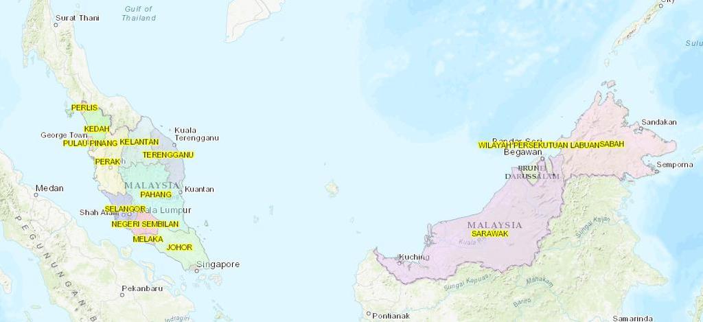
4 Malaysia Population (Millions) Census Male Female Location: Located between 2 and 7 degrees north of the Equator, Peninsular Malaysia is separated from the states of Sabah and Sarawak by the South China Sea. To the north of Peninsular Malaysia is Thailand while its southern neighbour is Singapore. Sabah and Sarawak are bounded by Indonesia while Sarawak also shares a border with Brunei. Key Summary Statistics,Malaysia Population Density(per sq. km) Average annual population growth rate, (%) Urban population(%)
5 5


6 6 Established in 1949 under the Statistics Ordinance 1949 A premier government agency under the Ministry of Economic Affairs entrusted with the responsibility to collect, interpret and disseminate latest and real time statistics in the monitoring of national economic performance and social development. VISION To Become A Leading Statistical Organisation Internationally by 2020 MISSION Producer of National Statistics of Integrity and Reliability 14 States DOSM 28 Operational Centres
 LAWS OF MALAYSIA REPRINT Act 16 CENSUS")
, the functions of DOSM [Section 2] are: To")


7 7 Statistics Act 1965 (Revised-1989) Census Act 1960 LAWS OF MALAYSIA Act 415 STATISTICS ACT1965 (REVISED-1989) LAWS OF MALAYSIA REPRINT Act 16 CENSUS ACT1960 Incorporating all amendments up to 1 January 2006 Under the Statistics Act1965 (Revised 1989), the functions of DOSM [Section 2] are: To collect and interpret statistics for the purpose of formulation or implementation of government policies. Under Census Act 1960: The Yang di-pertuan Agong may, by notification in the Gazette, from time to time direct that a census to be taken throughout Malaysia of the Population, Agriculture, Trade, Labor, Industry, Commerce.


8 8 Stakeholders International Users Public Researcher Universities Embassy Private Sectors Ministry / Government Agencies


9 9 Salaries & Wages Survey Report Current Population Estimates Labour Force Survey Report Household Income & Basic Amenities Survey Report Vital Statistics Quarterly & Annual Gross Domestic Product Consumer Price Index Monthly External Trade Statistics Index of Industrial Production, Malaysia Domestic Tourism Survey Balance of Payment Statistics on Women Empowerment In Selected Domains, Malaysia Labour Productivity Social Accounting Matrix Children Statistics, Malaysia


10 10 DOSM SAS Certified Data Scientist Tuesday, 16 January 2018 Courtesy visit by Monash University Malaysia Wednesday 03, January 2018 Courtesy Visit by Mr. James Lochhead, Consultant for Gender Mainstreaming Project Wednesday, 10 January 2018 STATSBDA Development Review Tuesday, 16 January 2018 Courtesy Visit by Vice Chancellor UNITEN Thursday 04, January 2018

 to ensure the member states to conduct a census during 2015 2024")
11 11 6 th CENSUS 2020 The Population and Housing Census in Malaysia is conducted every 10 years. Since the establishment of Malaysia, 5 census has been implemented. MAIN OBJECTIVE To have a total coverage and to accurately count and measure the numbers and key characteristics of the population, households and living quarters in Malaysia at a point in time LEGAL BASIS Census Act 1960 (Revised 1969). Statistics Act 1965 (Revised 1989). RESOLUTION Resolution on 2020 World Population and Housing Census Programme adopted by the ECOSOC (10 June 2015) to ensure the member states to conduct a census during period. MANUAL Principles and Recommendations for Population and Housing Censuses, Revision 3, UNSD (2015).


12 12 UN Principles and Recommendations for Population and Housing Censuses,, recommended the use of Geospatial technologies for improving traditional methods of census mapping (adopted by UNSC in 2007). Other recommendations derived from UN EGM on GIS and Census Mapping emphasized: the need for countries to consider the census geography programme as a continuous process the use of and application of geospatial technologies and information is beneficial at all stages of population and housing census process (GI improves the efficiency in the preparatory, enumeration, processing and dissemination phases of the census)
13 To compile the total coverage and profile of the population, households and living quarters in Malaysia with a wide range of demographic and socio-economic characteristics to the smallest area To provide input for planning, formulation and implementation of government policies and development programmes as stated in the Legislation 03 To provide a reliable basis for the estimation and projection of the population and living quarters 04 To provide input for the development of new socio-economic key indicators

14 14 LIVING QUARTERS POPULATION HOUSEHOLD OCCUPANCY CONNECTIVITY AGE SEX ETHNICITY TYPE OF HOUSEHOLD UTILITIES LOCAL AREA MIGRATION MARITAL STATUS RELIGION AGRICULTURE ACTIVITIES TYPES OF LIVING QUARTERS EDUCATION CITIZENSHIP ECONOMICS OWNERSHIP STATUS
15 15
16 Preparatory Stage After 1991 Census Create a census cartographic database
17 17 Malaysian Centre for Geospatial Data Infrastructure (MaCGDI) is a centre established by the government to manage and promote the development of geospatial data infrastructure for Malaysia (MyGDI). MaCGDI is also responsible for coordinating access and delivery of the geospatial information held by all government agencies. The main role of MaCGDI is to continuously make available and accessible current and accurate geospatial data that promotes a sustainable living environment, economic growth and social progress for public. Objectives: To provide mechanism/infrastructure in supporting the usage and sharing of current, accurate and reliable geospatial information among agencies by employing the latest geospatial technologies; and To avoid redundancy of duplicating effort in collecting, processing, maintaining, providing and dissemination of required geospatial information.
 was formed with the role of a central policy and decision making body on matters")

.")
18 18 MyGDI Governance To manage the development and operation of MyGDI, a MyGDI National Coordinating Committee (MNCC) was formed with the role of a central policy and decision making body on matters pertaining to the implementation, development and operations of MyGDI programmes and MaCGDI as the coordinator Framework Data refer to the coordinating data sharing within government agencies by establish fundamental dataset of National Geospatial Data Centre (NGDC) and State Geospatial Data Centre (SGDC). The objective is to prevent duplication of effort in data collection within government agencies.


19 19 Administrative Areas Statistical Areas
 Internal GIS Portal 2015 StatsDW Location intelligent Integration BI and GIS.")
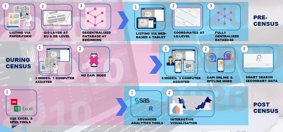
20 20 CENSUS MAPPING & DIGITAL MAPS Dissemination Data Statistical boundaries Development Statistical boundaries Vector data (topographic digital map) Census Geodatabase Integrating census with Statistical boundaries 2010 National Enterprise wide Statistical System (NEWSS) Internal GIS Portal 2015 StatsDW Location intelligent Integration BI and GIS MyIPCS Smart Listing and Smart Map Integration Data and Map

21 21 Delineation and digitizing of Enumeration Block (EB) boundaries for 2020 Census by using base maps from OGA. Establish the centralised geodatabase and internal GIS Portal for updating maps by State Office. Generating census data at small area statistics or specific area for the users. Producing thematic maps from various sources especially on Census and other data.


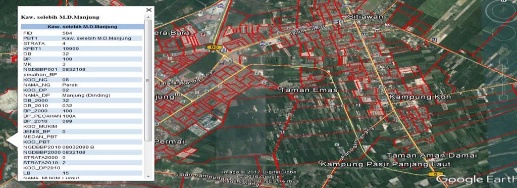
22 About 70% of statistical digital map were used for the 2010 census. All the map was produced using GIS software. EB s map -A3 sized maps up-dated based on base map from various resources 22

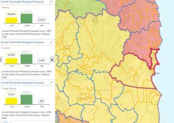
23 Census geopatial database at difference levels of geography. Small area statistics from census data which is consist of demographic data, living quarters, household, and others. 23


24 GIS internal portal; developed under National Enterprise Wide Statistical System (NEWSS). 24

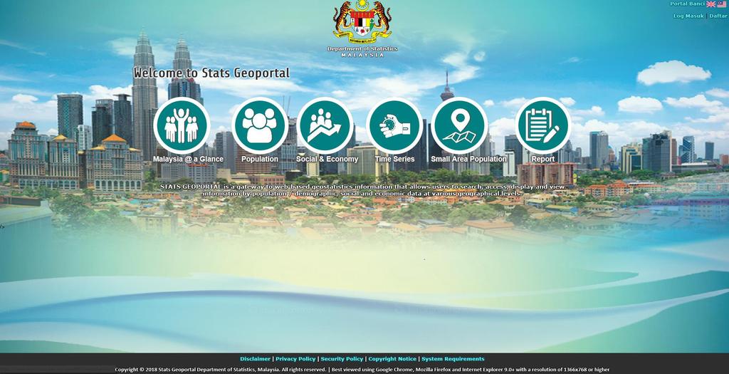
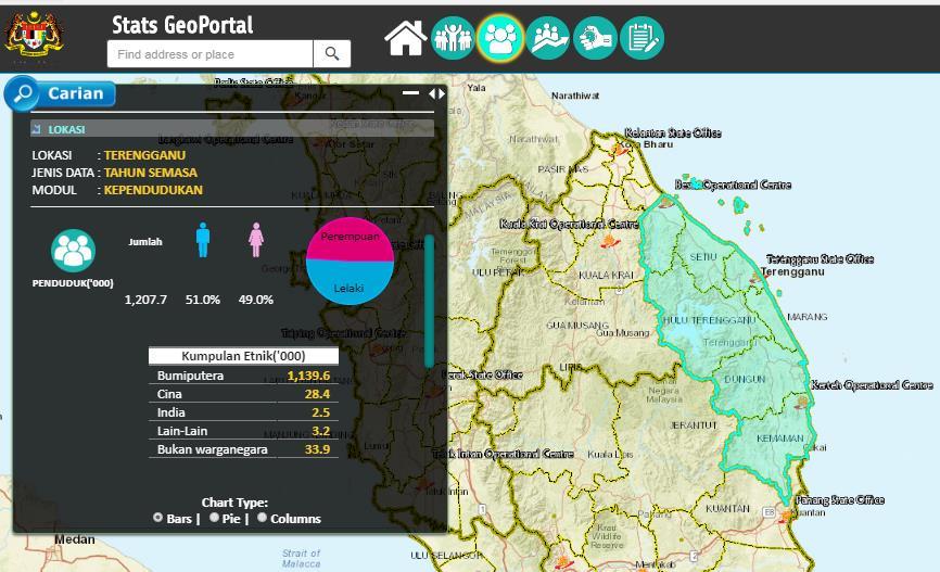
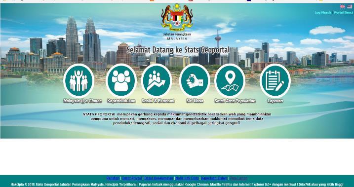
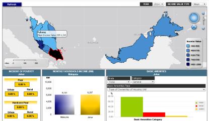
25 Census e-atlas developed using ArcGis Online platform- Changed to Stats Geo Portal It shows thematic maps of selected census data. 25
26 26
27 27

28 Data visualisation at Data visualisation tools allow anyone to organize and present information intuitively. 28

29 29 Lack of expertise and technical capabilities to enhance the use and development of GIS with the most updated technology. Need investment to purchase the most updated base maps/software especially on raster data. Integrating the variety of spatial data from OGA in order to create updated statistical maps.
30 Extending the scope of census cartography to the national spatial framework. Providing the most efficient platform for data dissemination through GIS Portal. Merging of household and establishment frames into the GIS environment. Constructing the EB geo database by using technical advances, such as Remote Sensing data, GPS. Strengthening the collaboration with OGA/GLC for map integration, standard and quality assurance. 30


31 Sources : International Workshop on Integrating Geospatial and Statistical Information, Beijing, China,
32 32


33 33 StatsBDA StatsDW CAPI StatsDigital CATI GIS e-survey MyIPCS NEWSS estatistik
 : MSAR, OSL 1 3 2 Increase Self-Response rate : e-census, MOMB, DOPU Integrating administrative data from OGA & survey data")
34 34 Census Portal as a one stop centre for the dissemination of information pre, current and post census Increased data security: Security/Risk Modernisation in field work: Mobile apps, tablet Modernisation of listing methods (Reengineering Address Canvassing/listing) : MSAR, OSL Increase Self-Response rate : e-census, MOMB, DOPU Integrating administrative data from OGA & survey data : MSAR & MSPR Malaysia Statistical Ubiquitous Learning (MySUL) Malaysia Census Strategic Communications Plan


35 35 STATS BDA Primary & Secondary Data MSAR + MSPR Online Self- Listing GIS CENSUS OPERATION e-census, CAPI, CATI, PAPI, DOPU GIS ANALYTIC & INTERACTIVE DATA MANAGEMENT STATISTICS DATABASE COMMUNICATION NATIONAL AGENDA INPUT Preparatory Work Enumeration Data Processing & Databases Dissemination Evaluation Principles and Recommendations for Population and Housing Censuses, Rev. 3 1 Specify Needs Design Build Collect Process Analyse Disseminate Evaluate Generic Statistical Business Process Model (GSBPM)


36 36
37 37


38 PRE-ENUMERATION Create and update statistical map Address geocode ENUMERATION Census tracking and progress monitoring during operation POST ENUMERATION Dissemination via Web based and spatial analysis


39 39 Period Process Process Platform Platform Base map map


40 40 Preliminary report Progress monitoring Census tracking

41 41 Preliminary report Progress monitoring Census tracking
42 42

43 43 Expand the integration of statistical and geospatial Strategic partnership with other agencies for the use of high resolution of spatial data Advanced the use of spatial analysis & tools for official statistics Extend the use of web based platform for dissemination of geo statistics


44 44 THANK YOU
GEOGRAPHIC INFORMATION SYSTEMS Session 8
 GEOGRAPHIC INFORMATION SYSTEMS Session 8 Introduction Geography underpins all activities associated with a census Census geography is essential to plan and manage fieldwork as well as to report results
The Global Statistical Geospatial Framework and the Global Fundamental Geospatial Themes
 The Global Statistical Geospatial Framework and the Global Fundamental Geospatial Themes Sub-regional workshop on integration of administrative data, big data and geospatial information for the compilation
Understanding China Census Data with GIS By Shuming Bao and Susan Haynie China Data Center, University of Michigan
 Understanding China Census Data with GIS By Shuming Bao and Susan Haynie China Data Center, University of Michigan The Census data for China provides comprehensive demographic and business information
Egypt Public DSS. the right of access to information. Mohamed Ramadan, Ph.D. [R&D Advisor to the president of CAPMAS]
![Egypt Public DSS. the right of access to information. Mohamed Ramadan, Ph.D. [R&D Advisor to the president of CAPMAS]](/thumbs/89/98483713.jpg "Egypt Public DSS. the right of access to information. Mohamed Ramadan, Ph.D. [R&D Advisor to the president of CAPMAS]") Egypt Public DSS ì the right of access to information Central Agency for Public Mobilization and Statistics Arab Republic of Egypt Mohamed Ramadan, Ph.D. [R&D Advisor to the president of CAPMAS] Egypt
Egypt Public DSS ì the right of access to information Central Agency for Public Mobilization and Statistics Arab Republic of Egypt Mohamed Ramadan, Ph.D. [R&D Advisor to the president of CAPMAS] Egypt
KUNMING FORUM ON UNITED NATIONS GLOBAL GEOSPATIAL INFORMATION MANAGEMENT CITIES OF THE FUTURE: SMART, RESILIENT
 KUNMING FORUM ON UNITED NATIONS GLOBAL GEOSPATIAL INFORMATION MANAGEMENT CITIES OF THE FUTURE: SMART, RESILIENT and SUSTAINABLE Yunnan Zhenzhuang Guest House, Kunming, China 10 12 May 2017 BACKGROUND CONCEPT
Geography for the 2020 Round of Census
 Boundaries Key Census Data EA Id Population Male Female EA Id Area EA Id Num HH Avg HH size Geography for the 2020 Round of Census Linda Peters, Esri lpeters@esri.com Integration of Statistical and Geospatial
Brazil Paper for the. Second Preparatory Meeting of the Proposed United Nations Committee of Experts on Global Geographic Information Management
 Brazil Paper for the Second Preparatory Meeting of the Proposed United Nations Committee of Experts on Global Geographic Information Management on Data Integration Introduction The quick development of
Presented to Sub-regional workshop on integration of administrative data, big data and geospatial information for the compilation of SDG indicators
 Presented to Sub-regional workshop on integration of administrative data, big data and geospatial information for the compilation of SDG indicators 23-25 April,2018 Addis Ababa, Ethiopia By: Deogratius
From PCGIAP to UN GGIM AP: A Regional Perspective on GGIM
 Regional Committee of United Nations Global Geospatial Information Management for Asia and the Pacific (UN-GGIM-AP) Established by a United Nations Resolution From PCGIAP to UN GGIM AP: A Regional Perspective
Spatial Statistical Information Services in KOSTAT
 Distr. GENERAL WP.30 12 April 2010 ENGLISH ONLY UNITED NATIONS ECONOMIC COMMISSION FOR EUROPE (UNECE) CONFERENCE OF EUROPEAN STATISTICIANS EUROPEAN COMMISSION STATISTICAL OFFICE OF THE EUROPEAN UNION (EUROSTAT)
Colin Bray, OSi CEO. Collaboration to develop a data platform for geospatial and statistical information in Ireland
 Colin Bray, OSi CEO Collaboration to develop a data platform for geospatial and statistical information in Ireland Organisations Ireland s National Mapping Agency Established in 1824 Operates under the
Combining Geospatial and Statistical Data for Analysis & Dissemination
 Combining Geospatial and Statistical Data for Analysis & Dissemination (with Special Reference to Qatar Census 2010) Presentation by Mansoor Al Malki, Director of IT Department Qatar Statistics Authority
Qatar Statistical Geospatial Integration
 Qatar Statistical Geospatial Integration A Presentation by the Ministry of Development Planning & Statistics (MDPS), State of Qatar http://www.mdps.gov.qa (Fourth UN-GGIM Arab States Committee Meeting,
2018/1 The integration of statistical and geospatial information. The Regional Committee of UN-GGIM: Americas:
 The following are the conclusions and recommendations of the Regional Committee of the United Nations on Global Geospatial Information Management for the Americas, during its Fifth Session, Thursday 8
Economic and Social Council
 United Nations Economic and Social Council Distr.: General 2 July 2012 E/C.20/2012/10/Add.1 Original: English Committee of Experts on Global Geospatial Information Management Second session New York, 13-15
Ministry of ICT of I.R.IRAN
 The ECO 8/6 mill km 2 10 Slamic countries ~330 mill people Oil, Gas, Industries,Tourism 2 Issue transformation in last decade Problem solving needs more integrated approach More interaction &complexity
Working with Census Operations Case Study from KSA
 Working with Census Operations Case Study from KSA International Workshop on Integrating Geospatial and Statistical Information Beijing 9 12 June 2014 Abdullah M.Alhamlan Kingdom of Saudi Arabia Central
Achieving the Vision Geo-statistical integration addressing South Africa s Developmental Agenda. geospatial + statistics. The Data Revolution
 Achieving the Vision Geo-statistical integration addressing South Africa s Developmental Agenda geospatial + statistics The Data Revolution humble beginnings, present & future - South Africa UN World Data
Country Report On Sdi Activities In Singapore ( )
") UNITED NATIONS E/CONF.102/IP.4 ECONOMIC AND SOCIAL COUNCIL Nineteenth United Nations Regional Cartographic Conference for Asia and the Pacific Bangkok, 29 October 1 November 2012 Item 6(b) of the provisional
UNITED NATIONS E/CONF.102/IP.4 ECONOMIC AND SOCIAL COUNCIL Nineteenth United Nations Regional Cartographic Conference for Asia and the Pacific Bangkok, 29 October 1 November 2012 Item 6(b) of the provisional
KENYA NATIONAL BUREAU OF STATISTICS Workshop on
 KENYA NATIONAL BUREAU OF STATISTICS Workshop on Capacity Building in Environment Statistics: the Framework for the Development of Environment Statistics (FDES 2013) Coordination with Sector Ministries
Oman NSDI Business Values and Future Directions. Hassan Alawi Alghazali Acting Director General National Spatial Data Infrastructure
 Oman NSDI Business Values and Future Directions Hassan Alawi Alghazali Acting Director General National Spatial Data Infrastructure Presentation Outline Geospatial Maturity Current Challenges NCSI s Role
GROUP ON INTEGRATION OF STATISTICAL AND GEOSPATIAL INFORMATION GT-IIEG
 UN-GGIM: Americas WORKING GROUP ON INTEGRATION OF STATISTICAL AND GEOSPATIAL INFORMATION GT-IIEG Bogotá, Colombia August, 2018 www.dane.gov.co Working group GT-IIEG Objective: To raise awareness and promote
Economic and Social Council
 United Nations Economic and Social Council Distr.: General 15 May 2012 Original: English E/CONF.101/4 Tenth United Nations Conference on the Standardization of Geographical Names New York, 31 July 9 August
The Integrated Ge spatial Information Framework to the strengthening of NSDI, Mongolia
 Young Geospatial Professionals Summit 21 NOV 2018 The Integrated Ge spatial Information Framework to the strengthening of NSDI, Mongolia BAYARMAA ENKHTUR Geospatial information and technology department
Compact guides GISCO. Geographic information system of the Commission
 Compact guides GISCO Geographic information system of the Commission What is GISCO? GISCO, the Geographic Information System of the COmmission, is a permanent service of Eurostat that fulfils the requirements
UN GGIM and National SDI Strategy
 MSDI Open Forum on 26 th January 2016 Contributing to the successful delivery of MSDI UN GGIM and National SDI Strategy Hiroshi Murakami Deputy Administrator Geospatial Information Authority of Japan Geospatial
Voices from Private Sector: Insights for Future NSDI Development in Indonesia
 Voices from Private Sector: Insights for Future NSDI Development in Indonesia Ta n d a n g Yu l i a d i D w i P u t ra, Ryosuke S h i b a s a k i I n st i t u t e o f I n d u st r i a l S c i e n c e,
Report of the Regional Committee of UN-GGIM for Asia and the Pacific (UN-GGIM-AP)
") Report of the Regional Committee of UN-GGIM for Asia and the Pacific (UN-GGIM-AP) At the Eighth Session of UN-GGIM UN Headquarters, New York, 1 3 August 2018 About UN-GGIM-AP One of the five regional committees
Report of the Regional Committee of UN-GGIM for Asia and the Pacific (UN-GGIM-AP) At the Eighth Session of UN-GGIM UN Headquarters, New York, 1 3 August 2018 About UN-GGIM-AP One of the five regional committees
Creating synergies between Statistical and Geospatial information for better policy outputs: The case of Mexico
 Creating synergies between Statistical and Geospatial information for better policy outputs: The case of Mexico Geospatial & Statistics Integration for Informed Decision Making Geospatial World Forum 2017
Demographic Data in ArcGIS. Harry J. Moore IV
 Demographic Data in ArcGIS Harry J. Moore IV Outline What is demographic data? Esri Demographic data - Real world examples with GIS - Redistricting - Emergency Preparedness - Economic Development Next
1) United Nations Committee of Experts on Global Geospatial Information Management (UN-GGIM)
 United Nations Committee of Experts on Global Geospatial Information Management (UN-GGIM)") International Workshop on Legal and Policy Frameworks for Geospatial Information Management Licensing of Geospatial Information 7 9 November 2017 Tianjin Zhengxie Club Hotel Tianjin, China Outline of presentation
International Workshop on Legal and Policy Frameworks for Geospatial Information Management Licensing of Geospatial Information 7 9 November 2017 Tianjin Zhengxie Club Hotel Tianjin, China Outline of presentation
Marine SDI supporting MyGDI
 IHO MSDI Demonstration Workshop and Open Forum Marine SDI supporting MyGDI Kamaruddin Yusoff National Hydrographic Centre 26 Jan 2016 EAHC Capacity Building Programme - MSDI and Database Management Bangkok,
A proposal for building an infrastructure for European geospatial statistics
 A proposal for building an infrastructure for European geospatial statistics Marie Haldorson, Statistics Sweden Ekkehard Petri, Eurostat What is geospatial statistics? The location, extent or spatial relations
Integration for Informed Decision Making
 Geospatial and Statistics Policy Intervention: Integration for Informed Decision Making Greg Scott Global Geospatial Information Management United Nations Statistics Division Department of Economic and
Merging statistics and geospatial information
 Merging statistics and geospatial information Demography / Commuting / Spatial planning / Registers Mirosław Migacz Chief GIS Specialist Janusz Dygaszewicz Director Central Statistical Office of Poland
Second Administrative Level Boundaries (SALB) initiative & geographic names in cartography. Geospatial Information Section
 initiative & geographic names in cartography. Geospatial Information Section") Second Administrative Level Boundaries (SALB) initiative & geographic names in cartography Geospatial Information Section Introduction Goals Global agenda How does SALB work? Latest News on geographic
Second Administrative Level Boundaries (SALB) initiative & geographic names in cartography Geospatial Information Section Introduction Goals Global agenda How does SALB work? Latest News on geographic
National Disaster Management Centre (NDMC) Republic of Maldives. Location
 Republic of Maldives. Location") National Disaster Management Centre (NDMC) Republic of Maldives Location Country Profile 1,190 islands. 198 Inhabited Islands. Total land area 300 sq km Islands range b/w 0.2 5 sq km Population approx.
National Disaster Management Centre (NDMC) Republic of Maldives Location Country Profile 1,190 islands. 198 Inhabited Islands. Total land area 300 sq km Islands range b/w 0.2 5 sq km Population approx.
UN-GGIM: An Overview Stefan Schweinfest, Director (UNSD) Bangkok, 27 March 2015
 Bangkok, 27 March 2015") UN-GGIM: An Overview Stefan Schweinfest, Director (UNSD) Bangkok, 27 March 2015 ggim.un.org UN-GGIM: A global initiative Formal inter-governmental UN Committee of Experts to: Discuss, enhance and coordinate
UN-GGIM: An Overview Stefan Schweinfest, Director (UNSD) Bangkok, 27 March 2015 ggim.un.org UN-GGIM: A global initiative Formal inter-governmental UN Committee of Experts to: Discuss, enhance and coordinate
ECONOMIC AND SOCIAL COUNCIL
 UNITED NATIONS E/CONF.102/3 ECONOMIC AND SOCIAL COUNCIL Nineteenth United Nations Regional Cartographic Conference for Asia and the Pacific Bangkok, 29 October 1 November 2012 Item 4 of the provisional
Second High Level Forum on GGIM Seminar on Regional Cooperation in Geospatial Information Management Doha, Qatar, 7 February 2013
 Second High Level Forum on GGIM Seminar on Regional Cooperation in Geospatial Information Management Doha, Qatar, 7 February 2013 Overview on Geospatial Activities in Egypt BY : Eng.Nahla Seddik Mohamed
Implementation of the ESPON 2020 cooperation program. 16 January 2017 Anneloes van Noordt
 Implementation of the ESPON 2020 cooperation program 16 January 2017 Anneloes van Noordt Outline! ESPON Cooperation Program! Specific Objectives! Applied Research! Targeted Analysis! Database & Tools!
CENSUS MAPPING WITH GIS IN NAMIBIA. BY Mrs. Ottilie Mwazi Central Bureau of Statistics Tel: October 2007
 CENSUS MAPPING WITH GIS IN NAMIBIA BY Mrs. Ottilie Mwazi Central Bureau of Statistics E-mail: omwazi@npc.gov.na Tel: + 264 61 283 4060 October 2007 Content of Presentation HISTORICAL BACKGROUND OF CENSUS
Study Visit University of Applied Sciences Utrecht Netherlands
 Study Visit University of Applied Sciences Utrecht Netherlands Directorate-General for Territorial Development Lisbon 1 April 2014 1 Agenda Presentation Cadastre Department Surveying / Geodesy Department
A proposal for building an infrastructure for European geospatial statistics. Marie Haldorson, Statistics Sweden Ekkehard Petri, Eurostat
 A proposal for building an infrastructure for European geospatial statistics Marie Haldorson, Statistics Sweden Ekkehard Petri, Eurostat What is geospatial statistics? The location, extent or spatial relations
Economic and Social Council 2 July 2015
 ADVANCE UNEDITED VERSION UNITED NATIONS E/C.20/2015/11/Add.1 Economic and Social Council 2 July 2015 Committee of Experts on Global Geospatial Information Management Fifth session New York, 5-7 August
Integration of Geo spatial and Statistical Information: The Nepelese Experience
 Integration of Geo spatial and Statistical Information: The Nepelese Experience Krishna Raj B.C. Joint Secretary Ministry of Land Reform and Management, Nepal 11 June, 2014 Presentation Outline The Country
Implementing the Sustainable Development Goals: The Role of Geospatial Technology and Innovation
 Fifth High Level Forum on UN Global Geospatial Information Management Implementing the Sustainable Development Goals: The Role of Geospatial Technology and Innovation 28-30 November 2017 Sheraton Maria
Economic and Social Council
 United Nations Economic and Social Council Distr.: General 18 July 2016 Original: English Committee of Experts on Global Geospatial Information Management Sixth session New York, 3-5 August 2016 Item 2
Key Elements of the Geographical Information System of Mexico *
 UNITED NATIONS E/CONF.99/IP.1 ECONOMIC AND SOCIAL COUNCIL Ninth United Nations Regional Cartographic Conference for the Americas New York, 10-14 August 2009 Item 7(a) of the provisional agenda Strategy,
SDI DEVELOPMENT UPDATES OF INDONESIA
 SDI DEVELOPMENT UPDATES OF INDONESIA DR. ANTONIUS B. WIJANARTO Center For Management And Dissemination Of Geospatial Information GEOSPATIAL INFORMATION AUTHORITY GOVERNMENT OF THE REPUBLIC OF INDONESIA
Integrating Official Statistics and Geospatial Information NBS Experience
 Integrating Official Statistics and Geospatial Information NBS Experience Presented by Eng. Reda AL Sabbagh Director of IT Dept. Prepared by Eng. Adham Makky GIS Specialist Topics to be covered: Background
2010 Census Data Release and Current Geographic Programs. Michaellyn Garcia Geographer Seattle Regional Census Center
 2010 Census Data Release and Current Geographic Programs Michaellyn Garcia Geographer Seattle Regional Census Center 2010 Center of Population Located approximately 2.7 miles northeast of Plato, Missouri
Millions of Mappers Making a Difference
 Millions of Mappers Making a Difference Hundreds of Mappers: Uganda Open Mapping Program Learning through Serious Gaming: Open by geospatial technologies for disaster Bernard J MUHWEZI management practitioners
Working with ArcGIS Online
 Esri International User Conference San Diego, CA Technical Workshops July 12, 2011 Working with ArcGIS Online Bern Szukalski, Deane Kensok Topics for this Session ArcGIS Online Overview ArcGIS Online Content
UN-GGIM: Strengthening Geospatial Capability
 Fifth Plenary Meeting of UN-GGIM: Europe Brussels, 6-7 June 2018 UN-GGIM: Strengthening Geospatial Capability Walking the talk to leave no one behind Greg Scott, UN-GGIM Secretariat Environmental Statistics
UNCERTAINTY IN THE POPULATION GEOGRAPHIC INFORMATION SYSTEM
 UNCERTAINTY IN THE POPULATION GEOGRAPHIC INFORMATION SYSTEM 1. 2. LIU De-qin 1, LIU Yu 1,2, MA Wei-jun 1 Chinese Academy of Surveying and Mapping, Beijing 100039, China Shandong University of Science and
Chapter 1: Overview of Environment Statistics Characteristics and Challenges
 Chapter 1: Overview of Environment Statistics Characteristics and Challenges Workshop on Environment Statistics in support of the implementation of the Framework for the Development of Environment Statistics
Georeferencing and Satellite Image Support: Lessons learned, Challenges and Opportunities
 Georeferencing and Satellite Image Support: Lessons learned, Challenges and Opportunities Shirish Ravan shirish.ravan@unoosa.org UN-SPIDER United Nations Office for Outer Space Affairs (UNOOSA) UN-SPIDER
1 ST High Level Forum on United Nations Global Geoespatial Information Management GEOGRAPHIC REFERENCING OF ECONOMIC UNITS. México
 1 ST High Level Forum on United Nations Global Geoespatial Information Management Thematic Seminar 27 October, Korea 2011. GEOGRAPHIC REFERENCING OF ECONOMIC UNITS México CONTENTS Introduction Census Cartography
MALDIVES. Regional Expert Workshop On Land Accounting For SDG Monitoring & Reporting (25-27 th Sept 2017) - Fathimath Shanna, Aishath Aniya -
 - Fathimath Shanna, Aishath Aniya -") MALDIVES Regional Expert Workshop On Land Accounting For SDG Monitoring & Reporting (25-27 th Sept 2017) - Fathimath Shanna, Aishath Aniya - ABOUT MALDIVES Approximately 860 km long and 120 km wide Consists
MALDIVES Regional Expert Workshop On Land Accounting For SDG Monitoring & Reporting (25-27 th Sept 2017) - Fathimath Shanna, Aishath Aniya - ABOUT MALDIVES Approximately 860 km long and 120 km wide Consists
INSPIRE Basics. Vlado Cetl European Commission Joint Research Centre. https://ec.europa.eu/jrc/
 INSPIRE Basics Vlado Cetl European Commission Joint Research Centre https://ec.europa.eu/jrc/ Serving society Stimulating innovation Supporting legislation Outline SDI? Why European SDI? INSPIRE Policy
Disaster Management & Recovery Framework: The Surveyors Response
 Disaster Management & Recovery Framework: The Surveyors Response Greg Scott Inter-Regional Advisor Global Geospatial Information Management United Nations Statistics Division Department of Economic and
To achieve these Global Sustainable Development Goals, geospatial data are crucial.
 To achieve these Global Sustainable Development Goals, geospatial data are crucial. 2 http://www.globalgoals.org/ HIGH INCOME NATION SUSTAINABLE GROWTH SOCIALLY INCLUSIVE 3 http://etp.pemandu.gov.my/ 12
GIS Building Communities beyond National Borders (Building Successful Spatial Data Infrastructures) Nick Land, ESRI Europe
 Nick Land, ESRI Europe") GIS Building Communities beyond National Borders (Building Successful Spatial Data Infrastructures) Nick Land, ESRI Europe UK worst flooding in the last 60 years 350,000 households without drinking water
GIS Building Communities beyond National Borders (Building Successful Spatial Data Infrastructures) Nick Land, ESRI Europe UK worst flooding in the last 60 years 350,000 households without drinking water
Spatially Enabled Society
 International Seminar on Land Administration Trends and Issues in Asia and the Pacific Region Spatially Enabled Society Abbas Rajabifard Vice Chair PCGIAP-WG3 Vice-President (President Elect), GSDI Association
Preparing the GEOGRAPHY for the 2011 Population Census of South Africa
 Preparing the GEOGRAPHY for the 2011 Population Census of South Africa Sharthi Laldaparsad Statistics South Africa; E-mail: sharthil@statssa.gov.za Abstract: Statistics South Africa (Stats SA) s Geography
CHALLENGES IN CONDUCTING SURVEYS/CENSUSES
 WORKSHOP ON MONITORING FOOD SECURITY IN THE CONTEXT OF 2030 SUSTAINABLE DEVELOPMENT AGENDA 22-23 FEBRUARY 2017 ANKARA, TURKEY CHALLENGES IN CONDUCTING SURVEYS/CENSUSES WAQAR ASLAM PAKISTAN BUREAU OF STATISTICS
GIS Geographical Information Systems. GIS Management
 GIS Geographical Information Systems GIS Management Difficulties on establishing a GIS Funding GIS Determining Project Standards Data Gathering Map Development Recruiting GIS Professionals Educating Staff
Department of Economic and Social Affairs May 2007
 UNITED NATIONS SECRETARIAT ESA/STAT/AC.115/13 Department of Economic and Social Affairs May 2007 Statistics Division English only United Nations Expert Group Meeting on Contemporary Practices in Census
Use of GIS/GPS in Support of the Philippines 2020 Census of Population and Housing
 Use of GIS/GPS in Support of the Philippines 2020 Census of Population and Housing Regional Workshop on the Use of Electronic Data Collection Technology in Population and Housing Censuses UN ESCAP, Bangkok
Building a National Data Repository
 Building a National Data Repository Mladen Stojic, Vice President - Geospatial 1/30/2013 2012 Intergraph Corporation 1 Information has meaning and gives power only when shared and distributed. Information,
Challenges and Successes in Sharing Geospatial Data in Africa
 Challenges and Successes in Sharing Geospatial Data in Africa 2018 GeoNode Summit Torino, Italy March 26-28, 2018 Bernard Justus Muhwezi Manager, Geo-Information Services Uganda Bureau of Statistics, Kampala,
Geographical Names Activities in Africa The Gaborone Action Plan
 United Nations Group of Experts on Geographical Names Geographical Names Activities in Africa The Gaborone Action Plan 6 th Meeting of the Committee of Director -Generals of National Statistics Offices
Land Use in the context of sustainable, smart and inclusive growth
 Land Use in the context of sustainable, smart and inclusive growth François Salgé Ministry of sustainable development France facilitator EUROGI vice president AFIGéO board member 1 Introduction e-content+
Principle 3: Common geographies for dissemination of statistics Poland & Canada. Janusz Dygaszewicz Statistics Poland
 Principle 3: Common geographies for dissemination of statistics Poland & Canada Janusz Dygaszewicz Statistics Poland Reference materials Primary: Ortophotomap, Cadastral Data, Administrative division borders,
Briefing. H.E. Mr. Gyan Chandra Acharya
 Briefing by H.E. Mr. Gyan Chandra Acharya Under-Secretary-General and High Representative for the Least Developed Countries, Landlocked Developing Countries and Small Island Developing States Briefing
ArcGIS Platform For NSOs
 ArcGIS Platform For NSOs Applying GIS and Spatial Thinking to Official Statistics Esri UC 2014 Demo Theater Applying GIS at the NSO Generic Statistical Business Process Model (GSBPM) 1 Specify Needs 2
Oman NSDI Supporting Economic Development. Saud Al-Nofli Director of Spatial Data Directorate General of NSDI, NCSI
 Oman NSDI Supporting Economic Development 2017 Saud Al-Nofli Director of Spatial Data Directorate General of NSDI, NCSI "It s critical to make correct decisions the first time to optimize the Investments
Geographical Names: Relevance and place within the UN-GGIM framework
 Geographical Names: Relevance and place within the UN-GGIM framework Greg Scott Inter-Regional Advisor Global Geospatial Information Management United Nations Statistics Division UN-GGIM: A global initiative
ESCAP Promotes Geo-referenced Information System for Disaster Risk Management in Asia and the Pacific
 Third High Level Forum on UNGGIM 22-24 October 2014 Beijing, China ESCAP Promotes Geo-referenced Information System for Disaster Risk Management in Asia and the Pacific Keran Wang Space Applications Section,
The Geospatial Census: plans and progress for the 2010 round of population censuses
 The Geospatial Census: plans and progress for the 2010 round of population censuses David Rain, Assistant Professor of Geography & International Affairs, and Consultant to the United Nations/UNSD drain@gwu.edu
Arctic Spatial Data Infrastructure Enabling Access to Arctic Location-Based Information
 Arctic Spatial Data Infrastructure Enabling Access to Arctic Location-Based Information Arctic SDI Side Event Co-Chairs: Arvo Kokkonen Arctic SDI Board Chair & Director General, National Land Survey of
National Cartographic Center
 National Cartographic Center NCC activities and accomplishments Activities of national organizations, institutions and universities in field of geomatics Large scale maps Medium scale maps Small scale
UN COMMITTEE OF EXPERTSON GLOBAL GEOSPATIAL INFORMATION MANAGEMENT. August 13 15, 2012 COUNTRY REPORT OF THE PHILIPPINES
 UN COMMITTEE OF EXPERTSON GLOBAL GEOSPATIAL INFORMATION MANAGEMENT August 13 15, 2012 COUNTRY REPORT OF THE PHILIPPINES National Mapping and Resource Information Authority Department of Environment and
FIRE DEPARMENT SANTA CLARA COUNTY
 DEFINITION FIRE DEPARMENT SANTA CLARA COUNTY GEOGRAPHIC INFORMATION SYSTEM (GIS) ANALYST Under the direction of the Information Technology Officer, the GIS Analyst provides geo-spatial strategic planning,
Country Report on SDI Activities in Singapore *
 UNITED NATIONS E/CONF.100/CRP.9 ECONOMIC AND SOCIAL COUNCIL Eighteenth United Nations Regional Cartographic Conference for Asia and the Pacific Bangkok, 26-29 October 2009 Item 7(a) of the provisional
Topographic Mapping in Australia: The Future State
 Topographic ping in Australia: The Future State Context Australia s geography and demography Greg Scott Group Leader National ping & Information Group Chair Permanent Committee for Topographic Information
Esri and GIS Education
 Esri and GIS Education Organizations Esri Users 1,200 National Government Agencies 11,500 States & Regional Agencies 30,800 Cities & Local Governments 32,000 Businesses 8,500 Utilities 12,600 NGOs 11,000
RESAP Progress Report
 RESAP Progress Report December 2016 to October 2017 Presentation to the Twenty-first session of the Intergovernmental Consultative Committee on the Regional Space Applications Programme for Sustainable
Indicator: Proportion of the rural population who live within 2 km of an all-season road
 Goal: 9 Build resilient infrastructure, promote inclusive and sustainable industrialization and foster innovation Target: 9.1 Develop quality, reliable, sustainable and resilient infrastructure, including
Lessons Learned from the production of Gridded Population of the World Version 4 (GPW4) Columbia University, CIESIN, USA EFGS October 2014
 Columbia University, CIESIN, USA EFGS October 2014") Lessons Learned from the production of Gridded Population of the World Version 4 (GPW4) Columbia University, CIESIN, USA EFGS October 2014 Gridded Population of the World Gridded (raster) data product
Lessons Learned from the production of Gridded Population of the World Version 4 (GPW4) Columbia University, CIESIN, USA EFGS October 2014 Gridded Population of the World Gridded (raster) data product
Background Document: Report of the Regional Committee of United Nations Global Geospatial Information Management for Asia and the Pacific
 Background Document: Report of the Regional Committee of United Nations Global Geospatial Information Management for Asia and the Pacific 1. Summary 1. This report highlights the activities carried out
COMPILATION OF ENVIRONMENTALLY-RELATED QUESTIONS IN CENSUSES AND SURVEY, AND SPECIALIZED ENVIRONMENTAL SURVEYS
 COMPILATION OF ENVIRONMENTALLY-RELATED QUESTIONS IN CENSUSES AND SURVEY, AND SPECIALIZED ENVIRONMENTAL SURVEYS 6. 2. Environment Environmental Protection, Resources and Management and their Use Engagement
HIGH RESOLUTION BASE MAP: A CASE STUDY OF JNTUH-HYDERABAD CAMPUS
 HIGH RESOLUTION BASE MAP: A CASE STUDY OF JNTUH-HYDERABAD CAMPUS K.Manjula Vani, Abhinay Reddy, J. Venkatesh, Ballu Harish and R.S. Dwivedi ABSTRACT The proposed work High Resolution Base map: A Case study
SPATIAL ANALYSIS OF POPULATION DATA BASED ON GEOGRAPHIC INFORMATION SYSTEM
 SPATIAL ANALYSIS OF POPULATION DATA BASED ON GEOGRAPHIC INFORMATION SYSTEM Liu, D. Chinese Academy of Surveying and Mapping, 16 Beitaiping Road, Beijing 100039, China. E-mail: liudq@casm.ac.cn ABSTRACT
Proposal for a DIRECTIVE OF THE EUROPEAN PARLIAMENT AND OF THE COUNCIL. establishing an infrastructure for spatial information in the Community
 Proposal for a DIRECTIVE OF THE EUROPEAN PARLIAMENT AND OF THE COUNCIL establishing an infrastructure for spatial information in the Community INSPIRE http://inspire.jrc.it/ Alessandro Annoni 1 EU Commission
Key Indicators for Territorial Cohesion & Spatial Planning Stakeholder Workshop - Project Update. 13 th December 2012 San Sebastián, Basque Country
 Key Indicators for Territorial Cohesion & Spatial Planning Stakeholder Workshop - Project Update 13 th December 2012 San Sebastián, Basque Country Key Aims Explore the use of territorial data in developing
GENERAL RECOMMENDATIONS. Session 7. Breakout discussion. discuss on regional and interregional. proposals 1. COLLABORATION BETWEEN PROGRAMMES
 Session 7 24 July 2016, 9.00-11.00 Breakout discussion on regional and interregional joint project proposals Mr Shahbaz Khan summarized the two days of presentations and exchanges and requested the participants
Final report for the Expert Group on the Integration of Statistical and Geospatial Information, May 2015
 Final report for the Expert Group on the Integration of Statistical and Geospatial Information, May 2015 Global geographic classification and geocoding practices Executive summary This final report was
Geographical Names: Detailing Map and Enhancing GIS
 Geographical Names: Detailing Map and Enhancing GIS Zainal A MAJEED, MALAYSIA Keywords: geographical names, GIS, geographic name standardization, toponymy SUMMARY The necessity of having geographical names