Summary of Presentation:
|
|
|
- Isabel Houston
- 6 years ago
- Views:
Transcription

1 Development of Geodetic GPS Infrastructure and Its : The Malaysia Experience BY Abd Majid.A.Kadir, Shahrum Ses, Kamaluddin Omar & Abdullah Hisam Omar Fac. of Geoinformation Science and Eng. Universiti Teknologi Malaysia Kadir Taib, Teng Chee Hua, Azhari Mohamed, Chang Leng Hua & Soeb Nordin Dept. of Surveying & Mapping Malaysia, Kuala Lumpur Seminar On GPS Dubai, United Arab Emirates 22 nd July 2003 Summary of Presentation: 1. Introduction 2. Classical Geodetic Infrastructure 3. Modern Geodetic Infrastructure 4. Development of Geocentric Datum for Malaysia GDM Future Directions 7. Conclusion 1
 Laos 10)Burma/Myanmar South East Asia Region Malaysia Introduction Geography Area: 329,749 sq.")
. People Nationality: Malaysian. Population (2000): 23.3 million.")
2 South East Asia Introduction South East Asia region consists of ten (10) countries: 1) Malaysia 2) Singapore 3) Indonesia 4) Philippines 5) Brunei 6) Cambodia 7) Vietnam 8) Thailand 9) Laos 10)Burma/Myanmar South East Asia Region Malaysia Introduction Geography Area: 329,749 sq. km Terrain: Coastal plains and interior, jungle-covered mountains Climate: Tropical. The South China Sea separates Peninsular Malaysia from East Malaysia on Borneo (640 km.). People Nationality: Malaysian. Population (2000): 23.3 million. Government Independence: August 31, 1957 Subdivisions: 13 states and three federal territories (Kuala Lumpur, Labuan Island, Putrajaya federal administrative territory) 2
 Introduction Department of Surveying and Mapping Malaysia (DSMM): Profile The Past in Brief 1885: The history of the Department of Survey and Mapping Malaysia (DSMM) began with the")
3 Malaysia: Topographic Visualization Introduction Mt. Kinabalu, Sabah Mt. Tahan, Pahang Highest Point in Peninsular Malaysia: Mt. Tahan (2,187 m) Highest Point in East Malaysia : Mt. Kinabalu (4,101 m) Introduction Department of Surveying and Mapping Malaysia (DSMM): Profile The Past in Brief 1885: The history of the Department of Survey and Mapping Malaysia (DSMM) began with the establishment of the Johor Survey Department and the Perak Trigonometrical Survey Department. 1909: The formation of the Malay States Survey Department (Federated Malay States). 1946: All state Survey Departments were unified under one single administration headed by the Surveyor-General. 1982: The integration of JUPEM under the Ministry of Land and Regional Development (Ministry of Land and Cooperative Development). Present: Modern Data Provider 3


 MRT has been")


")
4 The Department Role Introduction MISSION To provide efficient and high quality survey and mapping services and a geographical information dissemination system suitable for national requirements Classical Geodetic Infrastructure Triangulation Network of Peninsular Malaysia Malaysia Revised Triangulation (MRT) MRT has been used for geodetic, mapping, cadastral and several other activities since 1948 in Peninsular Malaysia MRT network consists of 77 geodetic, 240 primary, 837 secondary and 51 tertiary stations. No Parameter Reference Ellipsoid Origin Semi-major axis (a) Flattening (f) MRT Modified Everest Kertau, Pahang 6,377, /
 Flattening (f)")
 Malaysia Active GPS System consistent of 15 permanent GPS stations, which track GPS")

5 Classical Geodetic Infrastructure Triangulation Network of East Malaysia Borneo Triangulation (BT68) Timbalai Datum - Separate Network from Pen.Malaysia. No. 1 2 Parameter Reference Ellipsoid Origin BT68 Everest Timbalai,Sarawak Still used for geodetic, mapping and surveying 3 5 Semi-major axis (a) Flattening (f) 6,377, / Modern Geodetic Infrastructure Malaysia Active GPS System (MASS) Malaysia Active GPS System consistent of 15 permanent GPS stations, which track GPS satellites at an attitude of 20,000 km away in space and allow users in Malaysia to have 24 hour access of GPS data. These stations are strategically located throughout the country. Objectives To enable DSMM to carry out surveying and mapping functions more effectively. To maintain the National Reference Frame System at centimetre accuracy. To monitor and provide the user community with a coordinate system that is connected to the national and global reference frame. 5

 Existing PMPGN95 Modern Geodetic Infrastructure East Malaysia Primary Geodetic GPS Network (EMPGN) Established in 1997 and provide a consistent set of coordinates in the WGS84 datum")
6 Established in 1994 and provide a consistent set of coordinates in the WGS84 datum (PMPGN95). The network consists of 238 GPS stations with an average spacing of about 30km. Strengthening and readjustment of PMPGN95 to ITRF2000@0.00 : PMPGN2000 The horizontal accuracy of the PMPGN2000 are 1-2 part per million (ppm) and 3 to 5 ppm for vertical component Modern Geodetic Infrastructure Peninsular Malaysia Primary Geodetic GPS Network (PMPGN) Existing PMPGN95 Modern Geodetic Infrastructure East Malaysia Primary Geodetic GPS Network (EMPGN) Established in 1997 and provide a consistent set of coordinates in the WGS84 datum (EMPGN97). The network consists of 171 GPS stations with an average spacing of about 30km. Strengthening and readjustment of EMPGN97 to ITRF2000@0.00 : EMPGN2000 The horizontal accuracy of the EMPGN2000 are 1-2 part per million (ppm) and 3 to 5 ppm for vertical component Existing EMPGN97 6
7 Development of Geocentric Datum for Malaysia GDM2000 First Order GPS Network of East Malaysia Problems With Classical Datum Historically, Malaysian geodetic datums has been established since 19 th century using conventional surveying techniques and procedures Confined to small areas of the globe, fit to limited areas and to satisfy national mapping requirements. Local datums are not aligned with global geocentric coordinates frames. Existing datum not compatible with the wide spread use of satellite positioning systems and international recommendation. Two separate geodetic datums ( Peninsular Malaysia and East Malaysia) Realisation of GDM2000 GDM 2000 Implementation of Geocentric Datum GPS Data Collection (MASS stations, ) The data processing and adjustment of the MASS network Computation of the new geocentric datum coordinates at specific epoch. Determination of velocity model Strengthening and readjustment of Peninsular Malaysia Geodetic GPS Network (PMPGN95) and East Malaysia GPS Geodetic Network (EMPGN97) Transformation parameter computation. 7
8 Processing and Adjustment of MASS Network ( ) GDM 2000 Internal Accuracy: mm horizontal 4.4 mm height Final Adjustment accuracy: 3-16 mm horizontal 8-13 mm height Final Coordinates: Strengthening and Readjustment of PMGSN and EMGSN Strengthening of PPGN GDM ARAU P299 P298 GETI 6 P297 P290 P247 P244 P238 USMP P310 KUAL 5 P281 P274 P263 P221 P229 4 P213 P102 IPOH GP02 P255 P219 P258 GP28 GP32 KUAN GP06 GP24 GP36 GP37 KTPK GP21 3 GP98 GP18 GP43 GP47 M331 GP58 2 Mass Station GP84 GP54 Main Station GP50 UTMJ GP52 Check Station To provide control in GDM datum GPS campaign: Oct-Nov stations observed Connecting to MASS network New PMPGN and EMPGN with ITRF2000 control coordinates 8
9 GDM 2000 Transformation Parameter : PMPGN95 GDN2000 COMPONENT PARAMETER STD. DEV DX DY DZ RX RY RZ SCALE arc sec arc sec arc sec ppm x x x x 10-8 Digital Cadastral System CCDB ADJUSTMENT Input Connection Lines DATA SELECTION QUALITY CONTROL TEMP NDCDB SDCDB DATA INTEGRITY CHECK TRANSFORM EDITING Automated Database Conversion System NDCDB CCDB : Geocentric Based Cadastral Control Database SDCDB: State Digital Cadastral Database NDCDB : National Digital Cadastral Database ( Geocentric) 9
 Cadastral Control Database Design & Analysis")


10 Digital Cadastral System Zero Order Geodetic GPS Network (MASS Stations) Cadastral Control Database Design & Analysis Of CCDB First Order Geodetic GPS Network (30km Network) Computation of Geocentric Cassini & RSO Coordinates Cadastral Control Infrastructure 10km,2.5km,0.5km Ties to Cadastral Network CCDB The Cadastral Control Development Methodology Digital Cadastral System Primary Grid Secondary Grid GPS Control GPS Control Network GPS Control Geocentric Based Cadastral Control Infrastructure Geocentric Based Cadastral Control Database Cadastral Network Adjustment Based On Geocentric Datum 10
11 Mapping: Georeferencing Topographic Data to Geocentric Datum Methodology of Georeferencing CAMS/DTDB (RSO) LOCAL GEO-REFERENCING a. POLYNOMIAL TRANSFORAMTION (by graphic) b. DATUM TRANSFORMATION (by point) NDTDB (RSO) GEOCENTRIC INTEGRATION NDCDB (RSO) GEOCENTRIC ISSUES ANALYSIS Mapping: Georeferencing Topographic Data to Geocentric Datum 2D Reverse Transformation using RSO formulae [ N, E ] RSO [ LAT, LON ] MRT Local 3D Transformation using Bursa Wolf parameter model [ N, E ] RSO Geocentric 2D Direct Transformation using modified RSO parameter [ LAT, LON ] WGS84 Destination Datum Datum Transformation Procedure 11


12 Mapping: Georeferencing Topographic Data to Geocentric Datum Coordinates change of approx. 200 m Simple transformation process for mapping product but need dense GPS network for a higher accuracy fit. Change in coordinates of map features 1: 50, mm on the map 1:10, mm on the map Future mapping product will be base on GDM 2000 GPS Levelling GPS Levelling Concept MSL height was derived from the ellipsoidal heights using the following formula: H = h N Where H = Orthometric / MSL height derived from GPS/EGM96 h = Ellipsoidal (GPS) height N = Geoid height (based on EGM96 Geoid Model) 12


13 GPS Levelling Principle of Airborne Gravimetry System GPS Levelling Airborne Gravimetry Flight Paths 13


14 GPS Levelling Geoid of Sarawak and Sabah from downward continued gravity Fleet Navigation 14
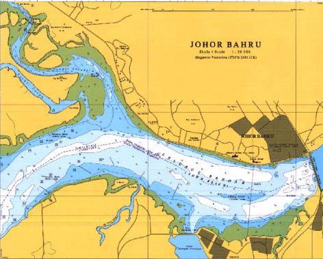

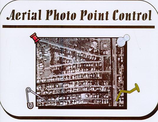
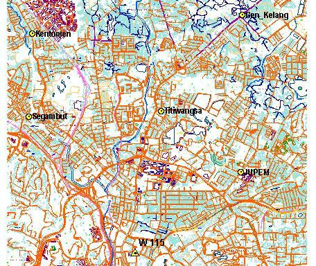
15 Hydrographic Surveying Airborne Photography Photo Control Kuala Lumpur Base Map 15
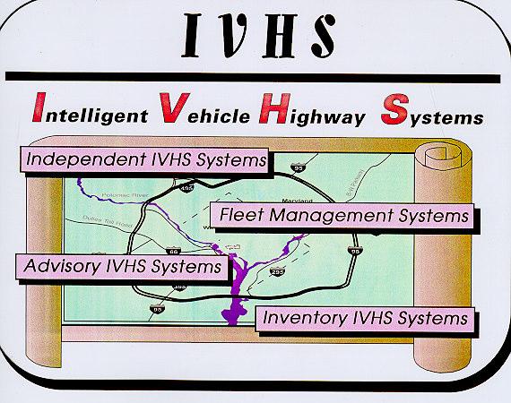


16 Intelligent Transportation System Petroleum Company 16


17 Electric Power Supply Company Control Station For Hydroelectric Dam Hydroelectric Dam Telecommunication Company 17


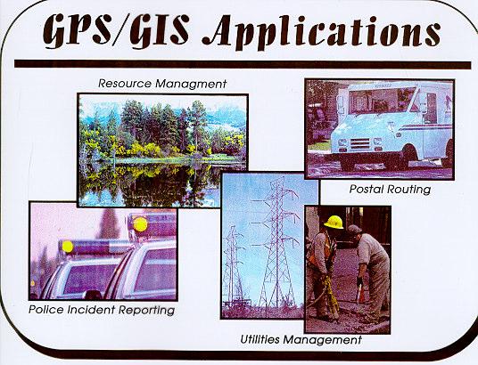
18 Precision Farming Mapping: GIS 18


19 Future Directions Development of GPS RTK Network for Sabah & Sarawak (SSRTK Net) 2004/2005 Sparse network: 18 stations covering the whole Sabah & Sarawak Two denser : covering Kuching and Kota Kota Kinabalu Development of GPS RTK Network for Peninsular Malaysia (PMRTK Net) 2003/2004 Sparse network: 20 stations covering the whole Peninsular Malaysia Two denser : covering Kuala Lumpur and Penang 19
KURSUS COORDINATED CADASTRAL SYSTEM (CCS) INSTITUT TANAH & UKUR NEGARA BEHRANG, PERAK
 INSTITUT TANAH & UKUR NEGARA BEHRANG, PERAK") KURSUS COORDINATED CADASTRAL SYSTEM (CCS) INSTITUT TANAH & UKUR NEGARA BEHRANG, PERAK TECHNIQUES FOR INTEGRATING THE DIGITAL COORDINATED CADASTRAL DATA WITH MAPPING DATA (MODULE C) OLEH: ASSOC.PROF DR
KURSUS COORDINATED CADASTRAL SYSTEM (CCS) INSTITUT TANAH & UKUR NEGARA BEHRANG, PERAK TECHNIQUES FOR INTEGRATING THE DIGITAL COORDINATED CADASTRAL DATA WITH MAPPING DATA (MODULE C) OLEH: ASSOC.PROF DR
Geodetic & Geospatial Infrastructure/Systems
 Geodetic & Geospatial Infrastructure/Systems 1. Geodetic System: Borneo Triangulation 1968 (BT68) 2. Geospatial System: Land and Survey Information System (LASIS) LAND AND SURVEY DEPARTMENT SARAWAK An
A National Geocentric Datum and the Administration of Marine Spaces in Malaysia 2
 A National Geocentric Datum and the Administration of Marine Spaces in Malaysia 2 CheeHai TEO 3 and Ahmad FAUZI 4 Abstract Malaysia is a country with two primary land masses, Peninsular Malaysia and East
Economic and Social Council
 United Nations Economic and Social Council Distr.: General 15 May 2012 Original: English E/CONF.101/4 Tenth United Nations Conference on the Standardization of Geographical Names New York, 31 July 9 August
UNITED NATIONS E/CONF.97/6/IP. 33
 UNITED NATIONS E/CONF.97/6/IP. 33 ECONOMIC AND SOCIAL COUNCIL Seventeenth United Nations Regional Cartographic Conference for Asia and the Pacific Bangkok, 18-22 September 2006 Item 7 of the provisional
Semi-Dynamic Datum of Indonesia
 Technical Seminar Reference Frame in Practice, Semi-Dynamic Datum of Indonesia H.Z. Abidin, A.B. Wijanarto, S.T. Wibowo, Susilo, J. Efendi Geospatial Information Agency, Indonesia (BIG) Sponsors: Page
The National Spatial Reference System of the Future
 The National Spatial Reference System of the Future William Stone Southwest Region (AZ, NM, NV, UT) Geodetic Advisor william.stone@noaa.gov NOAA s National Geodetic Survey geodesy.noaa.gov Salt Lake City
Report for 15th PCGIAP Meeting at 18th UNRCC-AP Working Group 1 Regional Geodesy
 Report for 15th PCGIAP Meeting at 18th UNRCC-AP Working Group 1 Regional Geodesy Chairman Shigeru Matsuzaka, Japan - shigeru@gsi.go.jp Vice Chairman Prof. Pengfei Cheng, China - chengpf@casm.ac.cn John
Geodetic Datum of Indonesian Maritime Boundaries: Status and Problems
 Geodetic Datum of Indonesian Maritime Boundaries: Status and Problems Hasanuddin Z. ABIDIN, Sobar SUTISNA, T. PADMASARI, J. KAHAR and Klaas J. VILLANUEVA, Indonesia Key words: Indonesia, Geodetic Datum,
NATRF 2022 AND LDP OCTOBER 11, 2017
 NATRF 2022 AND LDP OCTOBER 11, 2017 MODERNIZATION OF THE NSRS Why? Leaving passive control marks behind and relying solely on the CORS network for 3D positions: Older methodology relies on terrestrial
Working Group 1. Geodetic Reference Frame. Activity Report. for. The UN-GGIM-AP Plenary Meeting
 Regional Committee of United Nations Global Geospatial Information Management for Asia and the Pacific (UN-GGIM-AP) Established by a United Nations Resolution Working Group 1 Geodetic Reference Frame Activity
To achieve these Global Sustainable Development Goals, geospatial data are crucial.
 To achieve these Global Sustainable Development Goals, geospatial data are crucial. 2 http://www.globalgoals.org/ HIGH INCOME NATION SUSTAINABLE GROWTH SOCIALLY INCLUSIVE 3 http://etp.pemandu.gov.my/ 12
Geographical Names: Detailing Map and Enhancing GIS
 Geographical Names: Detailing Map and Enhancing GIS Zainal A MAJEED, MALAYSIA Keywords: geographical names, GIS, geographic name standardization, toponymy SUMMARY The necessity of having geographical names
Country Report On Sdi Activities In Singapore ( )
") UNITED NATIONS E/CONF.102/IP.4 ECONOMIC AND SOCIAL COUNCIL Nineteenth United Nations Regional Cartographic Conference for Asia and the Pacific Bangkok, 29 October 1 November 2012 Item 6(b) of the provisional
UNITED NATIONS E/CONF.102/IP.4 ECONOMIC AND SOCIAL COUNCIL Nineteenth United Nations Regional Cartographic Conference for Asia and the Pacific Bangkok, 29 October 1 November 2012 Item 6(b) of the provisional
CORS Network and Datum Harmonisation in the Asia-Pacific Region. Richard Stanaway and Craig Roberts
 CORS Network and Datum Harmonisation in the Asia-Pacific Region Richard Stanaway and Craig Roberts School of Surveying and Spatial Information Systems University of New South Wales CORS Networks in the
Height systems. Rudi Gens Alaska Satellite Facility
 Rudi Gens Alaska Satellite Facility Outline Why bother about height systems? Relevant terms Coordinate systems Reference surfaces Geopotential number 2 Why bother about height systems? give a meaning to
Updating and Re-establishment of Cadastral Control Points in Korea by Using GPS Observations
 Updating and Re-establishment of Cadastral Control Points in Korea by Using GPS Observations YANG Chul-Soo, Korea Key words: GPS, cadastral control point, datum transformation, network adjustment SUMMARY
Presented at the FIG Congress 2018, May 6-11, 2018 in Istanbul, Turkey
 Presented at the FIG Congress 2018, May 6-11, 2018 in Istanbul, Turkey Paper ID: 9253 (Peer Review) By: Amalina Izzati Abdul Hamid, Ami Hassan Md Din & Kamaludin Mohd Omar Geomatic Innovation Research
Evaluation of GPS in Orthometric Heights Determination in Khartoum State (Sudan)
") Evaluation of GPS in Orthometric Heights Determination in Khartoum State (Sudan) Dr. Nagi Zomrawi Mohammed 1, Dr. Abd Elrahim Elgizouli Mohammed 2 and Engineer Osman Bakry 3 1 Sudan University of Science
Evaluation of GPS in Orthometric Heights Determination in Khartoum State (Sudan) Dr. Nagi Zomrawi Mohammed 1, Dr. Abd Elrahim Elgizouli Mohammed 2 and Engineer Osman Bakry 3 1 Sudan University of Science
Geographic Information Systems class # 1 February 19, Coordinate reference systems in GIS: geodetic coordinates
 Geographic Information Systems class # 1 February 19, 2013 Coordinate reference systems in GIS: geodetic coordinates Manuel Campagnolo ISA Manuel Campagnolo (ISA) GIS/SIG 2012 2013 February 19, 2013 1
Shape of the Earth. Data Output by the Receiver
 It is quite common for confusion to arise about the process used during a hydrographic survey when GPS-derived water surface elevation is incorporated into the data as an RTK Tide correction. This article
Presented at the FIG Congress 2018, May 6-11, 2018 in Istanbul, Turkey
 Presented at the FIG Congress 2018, May 6-11, 2018 in Istanbul, Turkey A Geoid model of northern Chile from airborne and surface gravity Geographic Description of Chile. Total Surface: 2,006,096 Km 2.
BUILDING AN ACCURATE GIS
 BUILDING AN ACCURATE GIS 2006 GIS in the Rockies Denver, Colorado September 13, 2006 William E. Linzey United States Department of Commerce National Oceanic and Atmospheric Administration National Geodetic
GPS ELLIPSOID HEIGHT CALIBRATION TO DETERMINE THE APPROXIMATE MEAN SEA LEVEL (ORTHOMETRIC) HEIGHT
 HEIGHT") GPS ELLIPSOID HEIGHT CALIBRATION TO DETERMINE THE APPROXIMATE MEAN SEA LEVEL (ORTHOMETRIC) HEIGHT Dr. Abd Elrahim Elgizouli Mohamed Ahamed* Abstract: Through this paper a comparison between the ellipsoidal
GPS ELLIPSOID HEIGHT CALIBRATION TO DETERMINE THE APPROXIMATE MEAN SEA LEVEL (ORTHOMETRIC) HEIGHT Dr. Abd Elrahim Elgizouli Mohamed Ahamed* Abstract: Through this paper a comparison between the ellipsoidal
From PCGIAP to UN GGIM AP: A Regional Perspective on GGIM
 Regional Committee of United Nations Global Geospatial Information Management for Asia and the Pacific (UN-GGIM-AP) Established by a United Nations Resolution From PCGIAP to UN GGIM AP: A Regional Perspective
International Journal of Computer Science and Telecommunications [Volume 3, Issue 7, July 2012] 109. Levelling with GPS. Dr. Nagi Zomrawi Mohammed
![International Journal of Computer Science and Telecommunications [Volume 3, Issue 7, July 2012] 109. Levelling with GPS. Dr. Nagi Zomrawi Mohammed](/thumbs/94/120062601.jpg "International Journal of Computer Science and Telecommunications [Volume 3, Issue 7, July 2012] 109. Levelling with GPS. Dr. Nagi Zomrawi Mohammed") International Journal of Computer Science and Telecommunications [Volume 3, Issue 7, July 2012] 109 ling with ISSN 2047-3338 Dr. Nagi Zomrawi Mohammed Associate Professor, College of Engineering, Sudan
International Journal of Computer Science and Telecommunications [Volume 3, Issue 7, July 2012] 109 ling with ISSN 2047-3338 Dr. Nagi Zomrawi Mohammed Associate Professor, College of Engineering, Sudan
This presentation covers the following areas
 Geodetic Datums and Coordinate Systems for Surveying and Mapping in Hong Kong FIG Working Week 2012 Rome, Italy 6-10 May Simon KWOK Hong Kong, China 1 This presentation covers the following areas Explains
Report of PCGIAP to the 18 th United Nations Regional Cartographic Conference for Asia and the Pacific (UNRCC-AP) for the period
 for the period") Permanent Committee on GIS Infrastructure for Asia and the Pacific (PCGIAP) Established in 1995 by a United Nations Resolution Report of PCGIAP to the 18 th United Nations Regional Cartographic Conference
Permanent Committee on GIS Infrastructure for Asia and the Pacific (PCGIAP) Established in 1995 by a United Nations Resolution Report of PCGIAP to the 18 th United Nations Regional Cartographic Conference
Country Report on SDI Activities in Singapore *
 UNITED NATIONS E/CONF.100/CRP.9 ECONOMIC AND SOCIAL COUNCIL Eighteenth United Nations Regional Cartographic Conference for Asia and the Pacific Bangkok, 26-29 October 2009 Item 7(a) of the provisional
GEOID UNDULATIONS OF SUDAN USING ORTHOMETRIC HEIGHTS COMPARED WITH THE EGM96 ANG EGM2008
 GEOID UNDULATIONS OF SUDAN USING ORTHOMETRIC HEIGHTS COMPARED Dr. Abdelrahim Elgizouli Mohamed Ahmed* WITH THE EGM96 ANG EGM2008 Abstract: Positioning by satellite system determine the normal height above
Frames for the Future New Datum Definitions for Modernization of the U.S. National Spatial Reference System
 Figure 10. Horizontal position differences (in meters) between NAD 83 and ITRF 08 at time 2022.00 (January 1, 2022). Positional differences are shown for the North American and Pacific tectonic plates.
Proceedings of the First International Conference on Civil Engineering, Assiut University, Volume 2, pp , October 7-8.
 Proceedings of the First International Conference on Civil Engineering, Assiut University, Volume 2, pp. 246-253, October 7-8. PRODUCTIVE GPS TOPOGRAPHIC MAPPING FOR NATIONAL DEVELOPMENT PROJECTS IN EGYPT
Spatial Reference Systems. Introduction
 Spatial Reference Systems Wolfgang Kainz Professor of Cartography and Geoinformation Department of Geography and Regional Research University of Vienna wolfgang.kainz@univie.ac.at Introduction Historic
UNITED NATIONS E/CONF.96/CRP. 5
 UNITED NATIONS E/CONF.96/CRP. 5 ECONOMIC AND SOCIAL COUNCIL Eighth United Nations Regional Cartographic Conference for the Americas New York, 27 June -1 July 2005 Item 5 of the provisional agenda* COUNTRY
Vertical Reference Frame Pacific
 Vertical Reference Frame Pacific Andrick Lal SPC Geoscience Division GIS&RS User Conference 29 th November 2016 USP, Fiji. What does it mean? All buildings and features have a height. But what is it relative
COUNTRY REPORT ON CARTOGRAPHIC ACTIVITIES IN SINGAPORE ( ) Submitted by Singapore **
 Submitted by Singapore **") UNITED NATIONS E/CONF.97/5/CRP. 9 ECONOMIC AND SOCIAL COUNCIL Seventeenth United Nations Regional Cartographic Conference for Asia and the Pacific Bangkok, 18-22 September 2006 Item 6 (b) of the provisional
UNITED NATIONS E/CONF.97/5/CRP. 9 ECONOMIC AND SOCIAL COUNCIL Seventeenth United Nations Regional Cartographic Conference for Asia and the Pacific Bangkok, 18-22 September 2006 Item 6 (b) of the provisional
Modernization of National Geodetic Datum in China *
 UNITED NATIONS E/CONF.102/IP.16 ECONOMIC AND SOCIAL COUNCIL Nineteenth United Nations Regional Cartographic Conference for Asia and the Pacific Bangkok, 29 October 1 November 2012 Item 6(b) of the provisional
PROJECT FOR THE PRODUCTION OF 1/1000 SCALE BASE MAPS FROM COLOUR IMAGES USING DIGITAL CAMERAS IN BURSA METROPOLITAN AREA (BMA) IN TURKEY
 IN TURKEY") PROJECT FOR THE PRODUCTION OF 1/1000 SCALE BASE MAPS FROM COLOUR IMAGES USING DIGITAL CAMERAS IN BURSA METROPOLITAN AREA (BMA) IN TURKEY Şenol KUŞCU, M.Sait AYIK, Eray CAN, Hasan Yasar ARKAYIN, Turkey
PROJECT FOR THE PRODUCTION OF 1/1000 SCALE BASE MAPS FROM COLOUR IMAGES USING DIGITAL CAMERAS IN BURSA METROPOLITAN AREA (BMA) IN TURKEY Şenol KUŞCU, M.Sait AYIK, Eray CAN, Hasan Yasar ARKAYIN, Turkey
FIG Asia Pacific Capacity Development Network
 FIG Asia Pacific Capacity Development Network Report to the 41th General Assembly FIG Congress 2018, Istanbul - Turkey Rob Sarib Chair FIG Asia Pacific Capacity Development Network (AP CDN) Story of the
Background Document: Report of the Regional Committee of United Nations Global Geospatial Information Management for Asia and the Pacific
 Background Document: Report of the Regional Committee of United Nations Global Geospatial Information Management for Asia and the Pacific 1. Summary 1. This report highlights the activities carried out
Positioning in the Pacific Islands
 Positioning in the Pacific Islands Andrick Lal United Nations/Nepal Workshop on the Applications of Global Navigation Satellite Systems Kathmandu - Nepal 15 th December 2016 Presentation Outline Introduction
MODERNIZATION OF THE NSRS
 NATRF 2022 AND LDP SEPTEMBER 12, 2017 MODERNIZATION OF THE NSRS Why? Leaving passive control marks behind and relying solely on the CORS network for 3D positions: Older methodology relies on terrestrial
Positional Accuracy of the Google Earth Imagery In The Gaza Strip
 Positional Accuracy of the Google Earth Imagery In The Gaza Strip Maher A. El-Hallaq Associate Professor of Surveying Civil Engineering Department The Islamic University of Gaza, Palestine mhallaq@iugaza.edu.ps
Precise Hong Kong Geoid HKGEOID-2000
 Yong-Qi Chen 1, Zhicai Luo 1 and Simon Kwok 2 1.Department of Land Surveying and Geo-Informatics, The Hong Kong olytechnic University 2 Geodetic Survey Section, Lands Department, HKSAR Abstract: This paper
NGS is Scheduled to Replace NAVD 88 and NAD 83 In 2022
 NGS is Scheduled to Replace NAVD 88 and NAD 83 In 2022 Indiana Society of Professional Land Surveyors Conference January 2017 John Ellingson NGS Geodetic Advisor john.ellingson@noaa.gov 202-306-6904 1
The 3-D Global Spatial Data Model: Geometrical Foundation of the Global Spatial Data Infrastructure
 The 3-D Global Spatial Data Model: Geometrical Foundation of the Global Spatial Data Infrastructure Earl F. Burkholder, PS, PE Annotated Table of Contents July 8,2006 I. The Global Spatial Data Model (GSDM)
DERIVATION OF SEA LEVEL ANOMALY USING SATELLITE ALTIMETER. Ami Hassan Md Din, Kamaludin Mohd Omar
 DERIVATION OF SEA LEVEL ANOMALY USING SATELLITE ALTIMETER Ami Hassan Md Din, Kamaludin Mohd Omar Faculty of Geoinformation Science and Engineering Universiti Teknologi Malaysia Skudai, Johor E-mail: amihassan@utm.my
Development of the Kingdom of Tonga Cyclone Emergency Recovery and Management System using Geospatial Tools
 Development of the Kingdom of Tonga Cyclone Emergency Recovery and Management System using Geospatial Tools Case Studies from Small Island States FIG Commissions 3, 7 and 8 Malcolm Archbold General Manager
THE MODELLING OF CORRECTIVE SURFACE FOR GPS HEIGHT CONVERSION IN KLANG VALLEY
 THE MODELLING OF CORRECTIVE SURFACE FOR GPS HEIGHT CONVERSION IN KLANG VALLEY Abza Binti Khalid 1 and Zainal Abidin Bin Md Som 2 Faculty of Geoinformation and Real Estate, Universiti Teknologi Malaysia,
1 ST High Level Forum on United Nations Global Geoespatial Information Management GEOGRAPHIC REFERENCING OF ECONOMIC UNITS. México
 1 ST High Level Forum on United Nations Global Geoespatial Information Management Thematic Seminar 27 October, Korea 2011. GEOGRAPHIC REFERENCING OF ECONOMIC UNITS México CONTENTS Introduction Census Cartography
GEODETIC NETWORK OF SAUDI ARABIA AND FIDUCIAL STATIONS. GFN OF Saudi Arabia in Based on ITRF2000 Datum
 STUDIES OF TECTONIC MOVEMENTS IN SAUDI ARABIA USING CORS M. Al Rajhi, Ali Al Omar, R. Yanar, F. Kartal, K. Eren, SUBJECT TO TALKS BACKGROUND GEODETIC NETWORK OF SAUDI ARABIA AND FIDUCIAL STATIONS GFN OF
Fundamentals of Surveying (LE/ESSE ) Lecture 10
 Lecture 10") Fundamentals of Surveying (LE/ESSE 2620 3.0) Lecture 10 Topographic Mapping Dr.-Ing. Jianguo Wang Geomatics Engineering York University Fall 2017 1 10-1 Introduction Two main types of maps: Line maps Orthophotographic
Fundamentals of Surveying (LE/ESSE 2620 3.0) Lecture 10 Topographic Mapping Dr.-Ing. Jianguo Wang Geomatics Engineering York University Fall 2017 1 10-1 Introduction Two main types of maps: Line maps Orthophotographic
Shape e o f f the e Earth
 1 Coordinate Systems & Projections Coordinate Systems Two map layers are not going to register spatially unless they are based on the same coordinate system. 2 Contents Shape of the earth Datum Projections
SDI Development in the Russian Federation
 , the Russian Federation Key words: SDI development, the Russian Federation SUMMARY A reform in the field of spatial data is gathering headway in Russia. Creation of a single agency, which united state
A New Co-ordinate System for Sweden
 199 A New Co-ordinate System for Sweden M. LILJE, L. E. ENGBERG, B. ANDERSSON 1 Abstract Sweden introduced the three-dimensional reference frame SWEREF 99 in May 2001. It is based on the permanent GPS
Regional Climate Observation & Simulation of Extreme Temperature & Precipitation Trends
 Regional Climate Observation & Simulation of Extreme Temperature & Precipitation Trends By: M.K. Sammathuria & L.K. Ling Malaysian Meteorological Department Ministry of Science, Technology and Innovation
TOWARDS ROBUST LOCALIZATION OF RTK-GPS TOPOGRAPHIC SURVEYS 23
 TOWARDS ROBUST LOCALIZATION OF RTK-GPS TOPOGRAPHIC SURVEYS Jerry W. Nave, North Carolina A&T University; Tarig A. Ali, American University of Sharjah Abstract Localization is performed to fit the observed
Making the SDI Concept Relevant to Asia-Pacific Countries the PCGIAP Experience
 Making the SDI Concept Relevant to Asia-Pacific Countries the PCGIAP Experience Peter HOLLAND, Ian WILLIAMSON, Abbas RAJABIFARD and John MANNING, Australia Key words: cadastre, geodesy, GIS, PCGIAP, SDI,
PGM2016: A new geoid model for the. Philippines
 PGM2016: A new geoid model for the Philippines United Nations/Nepal Workshop on the Applications of Global Navigation Satellite Systems Kathmandu, Nepal December 12-16, 2016 Ronaldo Gatchalian, Chief Geodesy
HIMALAYAN AIRBORNE GRAVITY AND GEOID OF NEPAL
 Mt. Everest HIMALAYAN AIRBORNE GRAVITY AND GEOID OF NEPAL -Niraj Manandhar Head, Geodetic Survey Branch Survey Department, Geodetic Survey Branch Project Background Air Borne Gravity Survey Project was
Part : General Situation of Surveying and Mapping. The Development of Surveying and Mapping in China. The contents
 The Development of Surveying and Mapping in China Dr. Ping Xiao China.P.R The contents Part : General Situation of Surveying and Mapping 1. The legal systems of surveying and mapping 2. The technologies
SURVEYING Chapter 1 Introduction
 PHILADELPHIA UNIVERSITY Faculty of Engineering. Department of Civil Engineering. SURVEYING Chapter 1 Introduction Surveying : the art or science of measuring and representing natural and artificial features
A New Co-ordinate System for Sweden
 A New Co-ordinate System for Sweden Lars E. Engberg, Bengt Andersson, Lotti Jivall, Mikael Lilje, Bo-Gunnar Reit Lantmäteriet, Geodetic Department, SE-801 82 Gävle, Sweden e-mail: lars.e.engberg@lm.se,
Georeferencing, Map Projections, Cartographic Concepts. -Coordinate Systems -Datum
 Georeferencing, Map Projections, Cartographic Concepts -Map Projections -Coordinate Systems -Datum Map projection is "the process of systematically transforming positions on the Earth's spherical surface
What is the PCGIAP? Overview on PCGIAP Activities and the Asia/Pacific Region. Membership. Background. Aims. Asia-Pacific SDI
 3rd FIG Regional Conference for Asia and the Pacific Jakarta, Indonesia, 3-7th October 2004 Overview on PCGIAP Activities and the Asia/Pacific Region What is the PCGIAP? Haji Matusin Matasan Surveyor General,
SIRGAS: Basis for Geosciences, Geodata, and Navigation in Latin America
 SIRGAS: Basis for Geosciences, Geodata, and Navigation in Latin America Claudio Brunini President of SIRGAS Universidad Nacional de La Plata, Argentina María Virginia Mackern President of SIRGAS/WG-I:
Positioning the Pacific: NOAA s Geospatial Activities. Juliana Blackwell, Director NOAA s National Geodetic Survey March 6, 2012
 Positioning the Pacific: NOAA s Geospatial Activities Juliana Blackwell, Director NOAA s National Geodetic Survey March 6, 2012 A Common Problem of the Early 19 th Century 1807 President Thomas Jefferson
Modernising the Northern Territory s GRS
 Modernising the Northern Territory s GRS Geospatial & GNSS CORS Forum Kuala Lumpur, Malaysia Amy Peterson; Rob Sarib DIPL Land Information Survey Services Sunday 16 October 2016 Presentation Outline Our
MSGIC Spring Mtg Denton April 23, 2014
 Modernization of the National Spatial Reference System Keeping Pace with Changes in Positioning Technology and User Expectations in a Dynamic World MSGIC Spring Mtg Denton April 23, 2014 Dave Doyle Base
Height systems. Rüdiger Gens
 Rüdiger Gens 2 Outline! Why bother about height systems?! Relevant terms! Coordinate systems! Reference surfaces! Geopotential number! Why bother about height systems?! give a meaning to a value defined
EnvSci360 Computer and Analytical Cartography
 EnvSci360 Computer and Analytical Cartography Lecture 3 Geodesy Map Projections, Datums, and Coordinate Systems 1 Geodesy The science of measuring and representing the shape and size of the earth, and
Geospatial Data Infrastructure in Myanmar
 SURVEY DEPARTMENT Republic of the Union of Myanmar Geospatial Data Infrastructure in Myanmar 16-17 October, 2016 Kuala Lumpur, Malaysia Contents General description Organization Establishment of Myanmar
Integration of Geo spatial and Statistical Information: The Nepelese Experience
 Integration of Geo spatial and Statistical Information: The Nepelese Experience Krishna Raj B.C. Joint Secretary Ministry of Land Reform and Management, Nepal 11 June, 2014 Presentation Outline The Country
GEOIDS FAQ. November
 GEOIDS FAQ 1. What is a geoid? A geoid is a representation of the equipotential surface of the Earth s gravity field. It can be thought of as a surface coinciding with the undisturbed mean sea level extended
A New Co-ordinate System for Sweden
 Lars E. ENGBERG and Mikael LILJE, Sweden Key words: SWEREF 99, Map Projections, UTM. ABSTRACT Sweden introduced the three-dimensional reference frame SWEREF 99 in May 2001. It is based on the permanent
NGS and the Modernization of the National Spatial Reference System (NSRS)
") NGS and the Modernization of the National Spatial Reference System (NSRS) Dr. Dana Caccamise Pacific Southwest Region (CA,NV) Geodetic Advisor dana.caccamise@noaa.gov NOAA s National Geodetic Survey geodesy.noaa.gov
NGS and the Modernization of the National Spatial Reference System (NSRS) Dr. Dana Caccamise Pacific Southwest Region (CA,NV) Geodetic Advisor dana.caccamise@noaa.gov NOAA s National Geodetic Survey geodesy.noaa.gov
When the Earth Was Flat. Measurements were made using a plumb bob, a spirit level, and a stick. Also, the Stars.
 ABSTRACT Defining the shape of the Earth geoid. Mathematical models spheroid or ellipsoid Mathematical projection of geodetic systems GIS/GPS technology The need for a unified projection systems World
REFINED GEOID MODEL FOR THE UNITED ARAB EMIRATES
 REFINED GEOID MODEL FOR THE UNITED ARAB EMIRATES Sahrum Ses 1, Adel Khaleefa and Rene Forsberg 3 1 UTM GNSS and Geodynamics Research Group, Universiti Teknologi Malaysia Military Survey Departments, GHQ
LEADS. The Essential Elements of a 3-D Geographic Coordinate
 The Essential Elements of a 3-D Geographic Coordinate John W. Dix 13 September 2005 ESRI Homeland Security GIS Summit - Denver, CO John.W.Dix@nga.mil NATIONAL GEOSPATIAL-INTELLIGENCE AGENCY Overview is
SPOT DEM Product Description
 SPOT DEM Product Description Version 1.1 - May 1 st, 2004 This edition supersedes previous versions Acronyms DIMAP DTED DXF HRS JPEG, JPG DEM SRTM SVG Tiff - GeoTiff XML Digital Image MAP encapsulation
Town of Chino Valley. Survey Control Network Report. mgfneerhg mc N. Willow Creek Road Prescott AZ
 Town of Chino Valley Survey Control Network Report mgfneerhg mc. 2050 N. Willow Creek Road Prescott AZ 86301 928-771-2376 Page 1 of 70 Table of Contents Town of Chino Valley Survey Datum Outline A short
Geo Referencing & Map projections CGI-GIRS 0910
 Geo Referencing & Map projections CGI-GIRS 0910 Where are you? 31UFT8361 174,7 441,2 51 58' NB 5 40' OL 2/60 Who are they? 3/60 Do geo data describe Earth s phenomena perfectly? Georeference systems ellipsoid
GEOGRAPHIC COORDINATE SYSTEMS
 GEOGRAPHIC COORDINATE SYSTEMS Introduction to GIS Winter 2015 What is Georeferencing? Used to establish a location on the Earth s surface 1 st order polynomial transformation Georeferencing toolbar What
System of Geodetic Parameters Parametry Zemli 1990 PZ-90.11
 System of Geodetic Parameters Parametry Zemli 1990 PZ-90.11 Authors: PhD Anastasiya N. Zueva, PhD Evgeniy V. Novikov, Dr. Dmitriy I. Pleshakov, PhD Igor V. Gusev Speaker: Igor Gusev 9 th Mee'ng of the
How GNSS CORS in Japan works for geodetic control and disaster mitigations
 ICG Working Group D Reference Frames, Timing and Applications How GNSS CORS in Japan works for geodetic control and disaster mitigations ICG11, Nov. 7-11, 2016, Sochi, Russia Hiromichi TSUJI Geodetic Observation
Georeferencing. Place names Postal addresses Postal codes Coordinate systems (lat/long, UTM, etc.)
") Georeferencing Georeferencing Used to describe the act of assigning locations to data or information Certain requirements include that they are: unique, have shared meaning, and are persistent through
Georeferencing Georeferencing Used to describe the act of assigning locations to data or information Certain requirements include that they are: unique, have shared meaning, and are persistent through
Preparation of Database for Urban Development
 Preparation of Database for Urban Development By PunyaP OLI, 1. Chairman, ERMC (P) Ltd., Kathmandu, Nepal. Email: punyaoli@ermcnepal.com 2. Coordinator, Himalayan College of Geomatic Engineering and Land
Geography involves the study of places: their locations, their characteristics, and how humans use and move around them.
 Physical Geography Looking at the Earth Geography involves the study of places: their locations, their characteristics, and how humans use and move around them. NEXT Physical Geography Looking at the Earth
CARTOGRAPHIC INFORMATION MANAGEMENT IN COLOMBIA REACH A LEVEL OF PERFECTION
 CARTOGRAPHIC INFORMATION MANAGEMENT IN COLOMBIA REACH A LEVEL OF PERFECTION Jaime Alberto Duarte Castro 1 Carrera 30 No. 48 51 Bogotá - Colombia, jduarte@igac.gov.co Claudia Inés Sepúlveda Fajardo 2 Carrera
D DAVID PUBLISHING. Towards a New Geoid Model of Tanzania Using Precise Gravity Data. 1. Introduction. Selassie David Mayunga
 Journal of Environmental Science and Engineering A 5 (2016) 267-276 doi:10.17265/2162-5298/2016.05.005 D DAVID PUBLISHING Towards a New Geoid Model of Tanzania Using Precise Gravity Data Selassie David
BANGLADESH SURVEY OF BANGLADESH PREMISES
 BANGLADESH SURVEY OF BANGLADESH PREMISES Survey of Bangladesh (SOB) is the National Mapping organization of Bangladesh SOB is carrying out all Geodetic activities of Bangladesh SOB is responsible for taking
Geog Lecture 29 Mapping and GIS Continued
 Geog 1000 - Lecture 29 Mapping and GIS Continued http://scholar.ulethbridge.ca/chasmer/classes/ Today s Lecture (Pgs 13-25, 28-29) 1. Hand back Assignment 3 2. Review of Dr. Peddle s lecture last week
Digital Topographic Mapping With Two Different Scales Using GPS And GIS On Adindan (Sudan) Datum
 Datum") INTERNATIONAL JOURNAL OF TECHNOLOGY ENHANCEMENTS AND EMERGING ENGINEERING RESEARCH, VOL 1, ISSUE 1 42 Digital Topographic Mapping With Two Different Scales Using GPS And GIS On Adindan (Sudan) Datum Abd
INTERNATIONAL JOURNAL OF TECHNOLOGY ENHANCEMENTS AND EMERGING ENGINEERING RESEARCH, VOL 1, ISSUE 1 42 Digital Topographic Mapping With Two Different Scales Using GPS And GIS On Adindan (Sudan) Datum Abd
What is Geodesy? Types of Geodesy terrestrial or classical geodesy space geodesy theoretical geodesy
 What is Geodesy? Geodesy is the study of: The size, shape and motion of the earth The measurement of the position and motion of points on the earth's surface, and The study of the earth's gravity field
CADASTRAL POSITIONING ACCURACY IMPROVEMENT: A CASE STUDY IN MALAYSIA
 CADASTRAL POSITIONING ACCURACY IMPROVEMENT: A CASE STUDY IN MALAYSIA N. M. Hashim a*, A. H. Omar a*, K.M. Omar a, N. M. Abdullah a, M. H. M. Yatim a, * a Dept. of Geomatic Engineering, University Technology
Height Modernization 2013 A New Canadian Vertical Datum
 Height Modernization 2013 A New Canadian Vertical Datum What is Height Modernization? The Height Reference System Modernization is a project at the Geodetic Survey Division (GSD) of Natural Resources Canada
GPS for Amateur Astronomer: How Wrong Can You Be?
 Buletin Geoinformasi, No.1, Jld.2. ms. 83-88, September 1997 Penerbitan Akademik Fakulti Kejuruteraan & Sains Geoinformasi GPS for Amateur Astronomer: How Wrong Can You Be? Mustafa Din Suberl Centre for
TOWARDS THE IMPLEMENTATION OF SEMI-DYNAMIC DATUM FOR MALAYSIA
 TOWARDS THE IMPLEMENTATION OF SEMI-DYNAMIC DATUM FOR MALAYSIA N. S. Shariff, J. Gill, Z. M. Amin, K. M. Omar Faculty of Geoinformation and Real-Estate, Universiti Teknologi Malaysia, 81310 Skudai, Johor
Consideration of a Global Vertical Reference System (GVRS) in the IERS Conventions
 in the IERS Conventions") Consideration of a Global Vertical Reference System (GVRS) in the IERS Conventions Johannes Ihde Federal Agency for Cartography and Geodesy (BKG) Chair of IAG ICP1.2 (2003-2007) Vertical Reference Frames
Consideration of a Global Vertical Reference System (GVRS) in the IERS Conventions Johannes Ihde Federal Agency for Cartography and Geodesy (BKG) Chair of IAG ICP1.2 (2003-2007) Vertical Reference Frames
CHILEAN PART OF SIRGAS REFERENCE FRAME, REALIZATION, ADOPTION, MAINTENANCE AND ACTUAL STATUS. Geodesy for Planet Earth IAG 2009, Buenos Aires
 CHILEAN PART OF SIRGAS REFERENCE FRAME, REALIZATION, ADOPTION, MAINTENANCE AND ACTUAL STATUS Geodesy for Planet Earth IAG 2009, Buenos Aires Ing. Héctor Parra hparra@igm.cl, IGM Chile Dr. Juan Báez jbaez@udec.cl,