Towards National Geographic Information System in Nepal
|
|
|
- Eunice Taylor
- 6 years ago
- Views:
Transcription

1 2 nd High Level Forum on Global Geospatial Information Management, Qatar National Convention Centre, Doha, Qatar, 4 6 February, 2013 Towards National Geographic Information System in Nepal Krishna Raj B.C. Joint Secretary Ministry of Land Reform and Management, Nepal 4 February, krishnabc@hotmail.com
2 Presentation Outline The Country Context NGIS initiatives in Nepal Major Geospatial Information Producers in Nepal Geospatial Information in Nepal Driving Forces for NGIS Few success stories Challenges Conclusion


3 Nepal Nepal, the Federal Democratic Republic Country nestled between India & China rests at the foot of the mighty Himalayas.

4 Nepal Home of Mount Everest Nepal is home to some of the world s highest mountain peaks, including Mt. Everest (8848 meters)


5 Nepal Home of Buddha Lumbini- Birthplace of Buddha


6 Kathmandu, the Capital... is the city of Temples Kathmandu is the home to living goddess Kumari, city of the temples, city of the festivals, city of the traditional architecture and famous for the world s heritage sites.
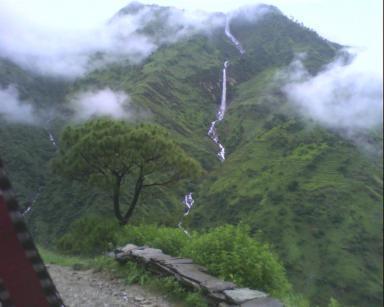


7 Nepal...Heavenly country side

8 Nepal.. Poverty Measure Index
9 Nepal..Economic Growth rate Source: Central bureau of statistics


10 Nepal.. Investment scenario ( ) and Govt. Prioritized sector Rs. in T H O U S A N D Source: Ministry of Finance
11 Ministry of Land Reform and Management.. Organizational Structure Ministry of Land Reform and Management Survey Department Land Reform and Management Department Department of Land Information and Archive Land Management Training Centre District Survey Offices 83 District Land Revenue Offices 83 District Land reform Offices staffs nationwide
12 NGIS initiative in Nepal National Geographic Information Infrastructure Project (NGIIP), as an NSDI initiative, established in 2000 NGII was envisioned as a way of enhancing the accessibility, communication, and use of geospatial information through adoption of a common architecture and best practices to support a wide variety of decisions at all levels of society. For better planning and policy making, effective mobilization of resources and making geospatial information sharable by maintaining consistency and standards in the country
13 NGIS initiative in Nepal.. Survey Department (NMO) is the nodal agency for developing NSDI. Efforts are underway in its development and expansion. LIS is under development Open Source Based System is also being developed Cadastral Information System Being Transformed to Digital System


14 NGII portal.. access to Geospatial information Select By Geography Indicator selection Log in & Register Search By location By themes Downloads
15 Major Geospatial Information Producers in Nepal Government Organizations Survey Department, the National Mapping Organization National Land Use Project Forest Resource Mapping Project Department of Urban Development and Building Construction among others Private Sector NGOs/INGOs ICIMOD WWF Nepal IUCN


16 Geospatial Information in Nepal 1. SERIES OF NATIONAL TOPOGRAPHICAL MAPS/ DATABASE Terai and Middle hills (scale 1:25000) High hills and Himalayas (scale 1:50000) Number of sheets 119 Map Scale 1: Number of sheets 563 Map Scale 1: a topographical map sheet 2. ORTHO-PHOTO MAPS /AERIAL PHOTOGRAPHS NEPAL National Geographic Information Infrastructure Programme, NGIIP Orthophoto Map Index LEGEND 1 : orthophoto mapping area 1 : orthophoto mapping area Both scales a Ortho photo map sheet


 4.")

17 Geospatial Information in Nepal.. 3. CADASTRAL MAPS THROUGHT THE COUNTRY Digitization and database development in 53 survey Offices is being done a cadastral map sheet (paper map/digital) 4. NATIONWIDE COVERAGE OF GEODETIC CONTROL NETWORKS HORIZONTAL VERTICAL AIRBORNE GRAVITY

18 Geospatial Information in Nepal.. 5. DIGITAL ELEVATION MODEL 6. NATIONWIDE COVERAGE OF LAND RESOURCE MAPS/DATABASE LAND USE MAPS LAND CAPABILITY MAPS LAND SUITABILITY MAPS SOIL MAPS

19 Geospatial Information in Nepal.. 7. SOCIO ECONOMIC ATLAS BASED ON POPULATION CENSUS THEMATIC MAPS ADMINISTRATIVE MAPS GEOLOGICAL MAPS PHYSOLOGICAL MAPS 9. GEOGRAPHICAL NAMES
20 Driving Forces Development Activities Increasing user demand Societal Transformation - Spatially Enabled Society / Government Spatially enabled decision and policy making
21 Success Stories Nepal as being a land locked and mountainous country having altitude from 60m to 8848m. Geospatial data capturing is always being challenging. In this context; National Topographic Maps and Database- widely used by the professional communities Nationwide coverage of cadastre-widely used by public Geodetic Control Network throughout the country Land Information System Solution on Land Administration (SOLA) Piloting aims to provide support for a more comprehensive range of district survey and land administration office functions
22 Challenges Technology Transformation Update-ness of the data Maintaining Consistencies and Standards of the data produced by various entities of the government and private sector Capacity Development Government Investment Availability of Infrastructure
23 Conclusion Spatially enabled planning and decision making practices are growing in recent years Fully developed NGIS is required, efforts are put in this line, however, NGIS is still immature in the country Prevailing challenges have to be resolved for the betterment and advancement in NGIS
24 Thank You For Your Attention
Challenges and Potentials of Place Based Information Management in Nepal"
 Nineteenth United Nations Regional Cartographic Conference for Asia and the Pacific, Bangkok, Thailand, 29 October 1 November 2012 Challenges and Potentials of Place Based Information Management in Nepal"
Integration of Geo spatial and Statistical Information: The Nepelese Experience
 Integration of Geo spatial and Statistical Information: The Nepelese Experience Krishna Raj B.C. Joint Secretary Ministry of Land Reform and Management, Nepal 11 June, 2014 Presentation Outline The Country
Agenda. Status of GI activities. NGII Framework. SDI from the national policy perspective
 Towards a National Geographic Information Infrastructure: Overcoming Impediments to the Development of SDI in Nepal R.R. Chhatkuli Email: chhatkuli@ngiip.gov.np & D.M. Kayastha Email: chhatkuli@ngiip.gov.np
Presented to Sub-regional workshop on integration of administrative data, big data and geospatial information for the compilation of SDG indicators
 Presented to Sub-regional workshop on integration of administrative data, big data and geospatial information for the compilation of SDG indicators 23-25 April,2018 Addis Ababa, Ethiopia By: Deogratius
Spatial Data Infrastructure for Prosperous Nepal
 Spatial Data Infrastructure for Prosperous Nepal Rabin K. SHARMA and Babu Ram ACHARYA, Nepal Key words: Metadata, Clearinghouse, Sustainable development, Good governance, SUMMARY This paper examines the
MALDIVES. Regional Expert Workshop On Land Accounting For SDG Monitoring & Reporting (25-27 th Sept 2017) - Fathimath Shanna, Aishath Aniya -
 - Fathimath Shanna, Aishath Aniya -") MALDIVES Regional Expert Workshop On Land Accounting For SDG Monitoring & Reporting (25-27 th Sept 2017) - Fathimath Shanna, Aishath Aniya - ABOUT MALDIVES Approximately 860 km long and 120 km wide Consists
MALDIVES Regional Expert Workshop On Land Accounting For SDG Monitoring & Reporting (25-27 th Sept 2017) - Fathimath Shanna, Aishath Aniya - ABOUT MALDIVES Approximately 860 km long and 120 km wide Consists
National Cartographic Center
 National Cartographic Center NCC activities and accomplishments Activities of national organizations, institutions and universities in field of geomatics Large scale maps Medium scale maps Small scale
Upgrade the Datasets in NSDI for Smarter Services with the Cases of China
 Upgrade the Datasets in NSDI for Smarter Services with the Cases of China By Dr. JIANG Jie Dept of GeoInformaiton Service Platform National Geomatics Center of China October 7, 2015 Jeju, Republic of Korea
Disaster Management in Mongolia
 The Third UN-GGIM-AP Plenary Meeting Disaster Management in Mongolia ~Coordination among NGIA & Other Related Organizations and Recommendations~ Bali Indonesia 10 November 2014 Khurelshagai Ayurzana, Director
Second High Level Forum on GGIM Seminar on Regional Cooperation in Geospatial Information Management Doha, Qatar, 7 February 2013
 Second High Level Forum on GGIM Seminar on Regional Cooperation in Geospatial Information Management Doha, Qatar, 7 February 2013 Overview on Geospatial Activities in Egypt BY : Eng.Nahla Seddik Mohamed
1 ST High Level Forum on United Nations Global Geoespatial Information Management GEOGRAPHIC REFERENCING OF ECONOMIC UNITS. México
 1 ST High Level Forum on United Nations Global Geoespatial Information Management Thematic Seminar 27 October, Korea 2011. GEOGRAPHIC REFERENCING OF ECONOMIC UNITS México CONTENTS Introduction Census Cartography
Demonstration of a local SDI solution with several stakeholders in pilot areas in line with EU best practices
 EU Twinning project for the Agency of Land Relations and Cadaster (ALRC)- Organization, Streamlining and Computerization Process in Mapping in the Republic of Moldova. Demonstration of a local SDI solution
Funding systems used in Mexico to support institutional arrangements: INEGI case
 Funding systems used in Mexico to support institutional arrangements: INEGI case Sistemas de financiamiento usados en México, para soportar arreglos institucionales: Caso INEGI United Nations Committee
Combining Geospatial and Statistical Data for Analysis & Dissemination
 Combining Geospatial and Statistical Data for Analysis & Dissemination (with Special Reference to Qatar Census 2010) Presentation by Mansoor Al Malki, Director of IT Department Qatar Statistics Authority
Spatial Statistical Information Services in KOSTAT
 Distr. GENERAL WP.30 12 April 2010 ENGLISH ONLY UNITED NATIONS ECONOMIC COMMISSION FOR EUROPE (UNECE) CONFERENCE OF EUROPEAN STATISTICIANS EUROPEAN COMMISSION STATISTICAL OFFICE OF THE EUROPEAN UNION (EUROSTAT)
Voices from Private Sector: Insights for Future NSDI Development in Indonesia
 Voices from Private Sector: Insights for Future NSDI Development in Indonesia Ta n d a n g Yu l i a d i D w i P u t ra, Ryosuke S h i b a s a k i I n st i t u t e o f I n d u st r i a l S c i e n c e,
GEOMATICS. Shaping our world. A company of
 GEOMATICS Shaping our world A company of OUR EXPERTISE Geomatics Geomatics plays a mayor role in hydropower, land and water resources, urban development, transport & mobility, renewable energy, and infrastructure
Preparation of Database for Urban Development
 Preparation of Database for Urban Development By PunyaP OLI, 1. Chairman, ERMC (P) Ltd., Kathmandu, Nepal. Email: punyaoli@ermcnepal.com 2. Coordinator, Himalayan College of Geomatic Engineering and Land
Global Geospatial Information Management Country Report Finland. Submitted by Director General Jarmo Ratia, National Land Survey
 Global Geospatial Information Management Country Report Finland Submitted by Director General Jarmo Ratia, National Land Survey Global Geospatial Information Management Country Report Finland Background
Pal NIKOLLI Bashkim IDRIZI Ismail KABASHI Adelajda HALILI THE IMPLEMENTATION OF NATIONAL SPATIAL DATA INFRASTRUCTURE IN ALBANIA
 Pal NIKOLLI Bashkim IDRIZI Ismail KABASHI Adelajda HALILI THE IMPLEMENTATION OF NATIONAL SPATIAL DATA INFRASTRUCTURE IN ALBANIA Overview: Goals of paper Some definitions of SDI NSDI Development NSDI in
Qatar s Nation-Wide GIS Cooperation on Local and Regional Levels
 Qatar s Nation-Wide GIS Cooperation on Local and Regional Levels Dr. Mohammad Abd El-Wahab Hamouda GIS Consultant & Chairman of GIS Coordinators Group The Center for GIS State of Qatar Second High Level
SDI Development in Georgia. Mari Khardziani Head of International Relations Unit National Agency of Public Registry
 SDI Development in Georgia Mari Khardziani Head of International Relations Unit National Agency of Public Registry Kehl, Germany September 5, 2017 2 National Agency of Public Registry Legal Entity of Public
Evolution and development of National Spatial Data Infrastructure in Republic of Moldova
 Agency for Land Relations and Cadastre of the Republic of Moldova Evolution and development of National Spatial Data Infrastructure in Republic of Moldova Alexandru Morcov Deputy general director ALRC
Roles of NGII in successful disaster management
 The Second UN-GGIM-AP Plenary Meeting Roles of NGII in successful disaster management Republic of Korea Teheran Iran 28 October 2013 Sanghoon Lee, Ph.D. NGII Outline Type of Disasters Occur in Korea Practical
Development of a Unified Spatial Infrastructure Status Index for Developing Nations
 Development of a Unified Spatial Infrastructure Status Index for Developing Nations Mohamed ABDEL-SALAM, Canada and Mohamed MOSTAFA, Egypt Key words: Spatial information infrastructure, unified index,
The Efforts of Building GIS Infrastructure in a Newly Independent State: The case of Timor Leste *
 UNITED NATIONS E/CONF.100/IP.12 ECONOMIC AND SOCIAL COUNCIL Eighteenth United Nations Regional Cartographic Conference for Asia and the Pacific Bangkok, 26-29 October 2009 Item 7(b) of the provisional
Land Board, NW Services and SDI Tambet Tiits, FRICS
 Land Board, NW Services and SDI Tambet Tiits, FRICS 07.09.2016 200th anniversary of the Struve Geodetic Arc Friedrich Georg Wilhelm Struve and Carl Friedrich Tenner Struve Geodetic Arc The Struve Geodetic
NSDI as a tool for Secure land tenure
 NSDI as a tool for Secure land tenure General Overview To look at the progress in SDI development and its application in policy formulation and impact on land tenure. INTEGRATION OF INFORMATION POLICIES
National Spatial Data Infrastructure International workshop 9 th June, 2015 Terelj Hotel, Mongolia
 1 st session: NSDI policy, planning and the legal framework Formation of NSDI policy and legal framework in Mongolia Khurelshagai Ayurzana, Director General, Administration of Land Affairs, Geodesy and
Turkey s National SDI Implementation
 Onur PAŞAOĞULLARI Head of Department Turkey s National SDI Implementation Presentation Plan NSDI Background General Directorate of Geographic Information Systems NSDI Project INSPIRE Directive Urban Information
Module - 3 GIS MAPPING, MIS AND GIS UNDER RAY
 Module - 3 1 GIS MAPPING, MIS AND GIS MIS INTEGRATION UNDER RAY Role of GIS & MIS under RAY Under the scheme, two step implementation strategy has been adopted i.e. preparation of SFCPoAs on whole city
Disaster Management in Republic of Korea
 The Third UN-GGIM-AP Plenary Meeting Disaster Management in Republic of Korea ~Coordination among NGIA & Other Related Organizations and Recommendations~ Bali Indonesia 10 November 2014 Sanghoon Lee, Ph.D.
BOTSWANA-TOWARDS A NATIONAL GEO-SPATIAL DATA INFRASTRUCTURE
 BOTSWANA-TOWARDS A NATIONAL GEO-SPATIAL DATA INFRASTRUCTURE Bryson B. H. MOREBODI, Botswana Key words: ABSTRACT The paper will review geo-spatially-related work over the last ten years with particular
Disaster Management & Recovery Framework: The Surveyors Response
 Disaster Management & Recovery Framework: The Surveyors Response Greg Scott Inter-Regional Advisor Global Geospatial Information Management United Nations Statistics Division Department of Economic and
PLACE-BASED INFORMATION MANAGEMENT FOR ECONOMIC GROWTH ADMINISTRATION OF LAND AFFAIRS, GEODESY AND CARTOGRAPHY
 PLACE-BASED INFORMATION MANAGEMENT FOR ECONOMIC GROWTH ADMINISTRATION OF LAND AFFAIRS, GEODESY AND CARTOGRAPHY 5 October 2012 CONTENTS Current situation of Geospatial information in Mongolia Usage of geospatial
IRDAT Fvg, evolving a regional Spatial Data Infrastructure according to INSPIRE
 IRDAT Fvg, evolving a regional Spatial Data Infrastructure according to INSPIRE Tutti i diritti riservati. Proprietà INSIEL SpA. A. Benvenuti, A. Chiarandini Insiel (Italy) M. Lunardis - Friuli Venezia
SDI DEVELOPMENT UPDATES OF INDONESIA
 SDI DEVELOPMENT UPDATES OF INDONESIA DR. ANTONIUS B. WIJANARTO Center For Management And Dissemination Of Geospatial Information GEOSPATIAL INFORMATION AUTHORITY GOVERNMENT OF THE REPUBLIC OF INDONESIA
GIS Geographical Information Systems. GIS Management
 GIS Geographical Information Systems GIS Management Difficulties on establishing a GIS Funding GIS Determining Project Standards Data Gathering Map Development Recruiting GIS Professionals Educating Staff
Country Report Nepal Geospatial Data Sharing Initiatives of Survey Department Supporting Disaster Management
 Third JPTM Step 2 for Sentinel Asia 6-8 July, 2010 Manila, The Philippines Country Report Nepal Geospatial Data Sharing Initiatives of Survey Department Supporting Disaster Management Durgendra M Kayastha
US National Spatial Data Infrastructure A Spatial Framework for Governance and Policy Development to Enable a Location-Based Digital Ecosystem
 GeoPlatform Workshop 7 Dec 2016, Department of the Interior Washington, D.C. US National Spatial Infrastructure A Spatial Framework for Governance and Policy Development to Enable a Location-Based Digital
The efforts building GIS infrastructure in a newly independent state The case of Timor Leste
 The efforts building GIS infrastructure in a newly independent state The case of Timor Leste Paulino da Cruz Ministry of Justice National Directorate of Land and Property and Cadastral Services (DNTPSC)
UNITED NATIONS E/CONF.96/CRP. 5
 UNITED NATIONS E/CONF.96/CRP. 5 ECONOMIC AND SOCIAL COUNCIL Eighth United Nations Regional Cartographic Conference for the Americas New York, 27 June -1 July 2005 Item 5 of the provisional agenda* COUNTRY
Sustainable and Harmonised Development for Smart Cities The Role of Geospatial Reference Data. Peter Creuzer
 Sustainable and Harmonised Development for Smart Cities The Role of Geospatial Reference Data Peter Creuzer 1. Introduction - Smart Cities and Geodata 2. Geodata in Germany 3. Examples 4. Data and Service
CENSUS MAPPING WITH GIS IN NAMIBIA. BY Mrs. Ottilie Mwazi Central Bureau of Statistics Tel: October 2007
 CENSUS MAPPING WITH GIS IN NAMIBIA BY Mrs. Ottilie Mwazi Central Bureau of Statistics E-mail: omwazi@npc.gov.na Tel: + 264 61 283 4060 October 2007 Content of Presentation HISTORICAL BACKGROUND OF CENSUS
Fundamental Geospatial Datasets in Africa. Andre Nonguierma New York, 03 August 2015
 Fundamental Geospatial Datasets in Africa United Nations Economic Commission for Africa Geoinformation & Spatial Statistics Andre Nonguierma New York, 03 August 2015 Core Data : Lack of consistency Infrastructure
Utilization and Provision of Geographical Name Information on the Basic Map of Japan*
 UNITED NATIONS WORKING PAPER GROUP OF EXPERTS NO. 1/9 ON GEOGRAPHICAL NAMES Twenty-eight session 28 April 2 May 2014 Item 9 of the Provisional Agenda Activities relating to the Working Group on Toponymic
INSPIRing Geospatial Framework For Local Administrations
 This project is financed by the European Union and the Republic of Turkey Presented at the FIG Congress 2018, May 6-11, 2018 in Istanbul, Turkey National Programme for Turkey 2010 Instrument for Pre-Accession
The Integrated Ge spatial Information Framework to the strengthening of NSDI, Mongolia
 Young Geospatial Professionals Summit 21 NOV 2018 The Integrated Ge spatial Information Framework to the strengthening of NSDI, Mongolia BAYARMAA ENKHTUR Geospatial information and technology department
THE CURRENT STATUS OF MAPPING IN THE WORLD - SPOTLIGHT ON PACIFIC ISLANDS
 THE CURRENT STATUS OF MAPPING IN THE WORLD - SPOTLIGHT ON PACIFIC ISLANDS John C. Trinder School of Civil and Environmental Engineering, UNSW SYDNEY NSW 2052, Australia (j.trinder@unsw.edu.au) Commission
Geographic Information Infrastructure and Policy Framework for Sustainable Mountain Development in the Hindu Kush-Himalayas
 Geo SMART ASIA 2017 22-24 August, Kualalampur Geographic Information Infrastructure and Policy Framework for Sustainable Mountain Development in the Hindu Kush-Himalayas Basanta Shrestha, Director Strategic
Economic and Social Council
 United Nations Economic and Social Council Distr.: General 18 July 2016 Original: English Committee of Experts on Global Geospatial Information Management Sixth session New York, 3-5 August 2016 Item 2
UN-GGIM: An Overview Stefan Schweinfest, Director (UNSD) Bangkok, 27 March 2015
 Bangkok, 27 March 2015") UN-GGIM: An Overview Stefan Schweinfest, Director (UNSD) Bangkok, 27 March 2015 ggim.un.org UN-GGIM: A global initiative Formal inter-governmental UN Committee of Experts to: Discuss, enhance and coordinate
UN-GGIM: An Overview Stefan Schweinfest, Director (UNSD) Bangkok, 27 March 2015 ggim.un.org UN-GGIM: A global initiative Formal inter-governmental UN Committee of Experts to: Discuss, enhance and coordinate
Report on the impact of open geographical data - Danish effect studies -
 Presented at the FIG Congress 2018, May 6-11, 2018 in Istanbul, Turkey Report on the impact of open geographical data - Danish effect studies - (Paper no 9603) Agenda 1. Intro teaser 2. Basic digital infrastructure
Brazil Paper for the. Second Preparatory Meeting of the Proposed United Nations Committee of Experts on Global Geographic Information Management
 Brazil Paper for the Second Preparatory Meeting of the Proposed United Nations Committee of Experts on Global Geographic Information Management on Data Integration Introduction The quick development of
Article: National Geographic Department
 Article: National Geographic Department A glimpse of the organization and its activities in brief June 2016 By: Mr. Khachonesack DOUANGPHOUTHA 1. Introduction Lao People s Democratic Republic or Laos is
From PCGIAP to UN GGIM AP: A Regional Perspective on GGIM
 Regional Committee of United Nations Global Geospatial Information Management for Asia and the Pacific (UN-GGIM-AP) Established by a United Nations Resolution From PCGIAP to UN GGIM AP: A Regional Perspective
Oman NSDI Business Values and Future Directions. Hassan Alawi Alghazali Acting Director General National Spatial Data Infrastructure
 Oman NSDI Business Values and Future Directions Hassan Alawi Alghazali Acting Director General National Spatial Data Infrastructure Presentation Outline Geospatial Maturity Current Challenges NCSI s Role
The Saudi Experience
 The Saudi Experience The need for NSDI A national GIS Concept Study 1992 NSDI Basic Components Formation of the National Committee Obstacles Conclusion Sharing and utilizing the Geospatial data Cost effective
INSPIRE Basics. Vlado Cetl European Commission Joint Research Centre. https://ec.europa.eu/jrc/
 INSPIRE Basics Vlado Cetl European Commission Joint Research Centre https://ec.europa.eu/jrc/ Serving society Stimulating innovation Supporting legislation Outline SDI? Why European SDI? INSPIRE Policy
Foundation Geospatial Information to serve National and Global Priorities
 Foundation Geospatial Information to serve National and Global Priorities Greg Scott Inter-Regional Advisor Global Geospatial Information Management United Nations Statistics Division UN-GGIM: A global
Exploring GIS Potential for Northwestern Ontario Land Information Ontario
 Exploring GIS Potential for Northwestern Ontario Land Information Ontario May 13, 2015 The LIO Vision LIO Vision: That all geographic information about Ontario is fully integrated and accessible LIO Goal:
FIG Views of GIS and NSDI
 FIG VIEWS OF GIS AND NSDI Jes RYTTERSGAARD and Jerome C. IVES, The International Federation of Surveyors (FIG) INTRODUCTION In a few years no one will think of spatial data as something special. Spatial
Qatar Statistical Geospatial Integration
 Qatar Statistical Geospatial Integration A Presentation by the Ministry of Development Planning & Statistics (MDPS), State of Qatar http://www.mdps.gov.qa (Fourth UN-GGIM Arab States Committee Meeting,
INSPIRATION results and benefits for the Agency for Real Estate Cadastre
 JOINT RESEARCH CENTER - E&I WORKSHOP INSPIRATION results and benefits for the Agency for Real Estate Cadastre Sonja Dimova, state advisor AGENCY FOR REAL ESTATE CADASTRE REPUBLIC OF MACEDONIA Wednesday,
National Disaster Management Centre (NDMC) Republic of Maldives. Location
 Republic of Maldives. Location") National Disaster Management Centre (NDMC) Republic of Maldives Location Country Profile 1,190 islands. 198 Inhabited Islands. Total land area 300 sq km Islands range b/w 0.2 5 sq km Population approx.
National Disaster Management Centre (NDMC) Republic of Maldives Location Country Profile 1,190 islands. 198 Inhabited Islands. Total land area 300 sq km Islands range b/w 0.2 5 sq km Population approx.
GIS FOR MAZOWSZE REGION - GENERAL OUTLINE
 GIS FOR MAZOWSZE REGION - GENERAL OUTLINE S. Bialousz 1), K Mączewski 2), E. Janczar 2), K. Osinska-Skotak 1) 1) Warsaw University of Technology, Warsaw, Poland 2) Office of the Surveyor of the Mazowieckie
Land Administration and Cadastre
 Geomatics play a major role in hydropower, land and water resources and other infrastructure projects. Lahmeyer International s (LI) worldwide projects require a wide range of approaches to the integration
Key Elements of the Geographical Information System of Mexico *
 UNITED NATIONS E/CONF.99/IP.1 ECONOMIC AND SOCIAL COUNCIL Ninth United Nations Regional Cartographic Conference for the Americas New York, 10-14 August 2009 Item 7(a) of the provisional agenda Strategy,
Current Status of the Standardization of Geographical Names in Cambodia
 1 Current Status of the Standardization of Geographical Names in Cambodia His Excellency Ith Sotha, Under Secretary of States, MLMUPC Mr Chharom Chin, Deputy Director, Geography Department, MLMUPC Mr Narith
Background Document: Report of the Regional Committee of United Nations Global Geospatial Information Management for Asia and the Pacific
 Background Document: Report of the Regional Committee of United Nations Global Geospatial Information Management for Asia and the Pacific 1. Summary 1. This report highlights the activities carried out
The Governance of Land Use
 The planning system Levels of government and their responsibilities The Governance of Land Use COUNTRY FACT SHEET NORWAY Norway is a unitary state with three levels of government; the national level, 19
Philippines NSDI Foundation Data Program. Andrew Bashfield
 Philippines NSDI Foundation Data Program Andrew Bashfield 1 Overview Part 1: Building the NSDI Framework Part 2: Collecting Foundation Datasets 2 Building the NSDI Framework Background & NDSI Overview
Geospatial SDI Portal for effective Governance of Pune METROPOLIS region
 Geospatial SDI Portal for effective Governance of Pune METROPOLIS region Mr. Praveen Gautam Senior Manager 19 th January 2018 PMRDA Overview Provide a Spatial Framework for the entire region with various
Manitoba s Elevation (LiDAR) & Imagery Datasets. Acquisition Plans & Opportunities for Collaboration
 & Imagery Datasets. Acquisition Plans & Opportunities for Collaboration") Manitoba s Elevation (LiDAR) & Imagery Datasets Acquisition Plans & Opportunities for Collaboration Manitoba Planning Conference May 2017 Presentation Outline Manitoba s Elevation (LiDAR) and Imagery Datasets
Manitoba s Elevation (LiDAR) & Imagery Datasets Acquisition Plans & Opportunities for Collaboration Manitoba Planning Conference May 2017 Presentation Outline Manitoba s Elevation (LiDAR) and Imagery Datasets
MAP STUDY: INTERPRETATION OF SURVEY MAPS
 MAP STUDY: INTERPRETATION OF SURVEY MAPS Types and Elements of Maps Maps are drawn to represent the Earth on a piece of paper. Maps are used widely to represent the Earth. Maps use signs and symbols in
UTAH S STATEWIDE GEOGRAPHIC INFORMATION DATABASE
 UTAH S STATEWIDE GEOGRAPHIC INFORMATION DATABASE Data Information and Knowledge Management NASCIO Awards 2009 STATE GEOGRAPHIC INFORMATION DATABASE B. EXECUTIVE SUMMARY Utah has developed one of the most
GIS Solutions in Natural Resource Management: Balancing the Technical- Political Equation
 GIS Solutions in Natural Resource Management: Balancing the Technical- Political Equation Stan Morain, Editor SUB Gdttlngen 7 208 520 309 98 A14447 0NW0RD PRESS V? % \
State of Israel Ministry of Housing and Construction Survey of Israel. The Hydrological project case
 State of Israel Ministry of Housing and Construction Survey of Israel The Hydrological project case Survey of Israel Content Introduction To the Survey of Israel The operation assumptions The main responsibilities
Geospatial and Statistical Data Integration
 Geospatial and Statistical Data Integration Dr. Emmanuel Nkurunziza Director General Outline I. About RCMRD II. Evolution of Rwanda s geospatial and statistics systems III. Statistics in Rwanda IV. Geospatial
FYROM A BRIEF HISTORICAL OVERVIEW ON EARTH OBSERVATION ACTIVITIES
 A BRIEF HISTORICAL OVERVIEW ON EARTH OBSERVATION ACTIVITIES The analog publication of the spatial data contents in the former Yugoslavian Republic of Macedonia dated from the end of the 19th century and
Development of NSDI in Moldova with donor funding
 Development of NSDI in Moldova with donor funding Maria OVDII, Ph. D Agency for Land Relations and Cadastre of Moldova E mail maria.ovdii@arfc.gov.md JRC WORKSHOP Financing the Evolution of Spatial Data
a national geological survey perspective François ROBIDA BRGM (French Geological Survey)
") a national geological survey perspective François ROBIDA BRGM (French Geological Survey) Pre-Conference Seminar on Socio-Economic Value of Geospatial for National and Regional Development 21 August 2017,
a national geological survey perspective François ROBIDA BRGM (French Geological Survey) Pre-Conference Seminar on Socio-Economic Value of Geospatial for National and Regional Development 21 August 2017,
Nordic Address Forum. Cooperation with Municipalities & The Geodata Strategy. Angela Fessé Lantmäteriet Odense, June
 Nordic Address Forum Cooperation with Municipalities & The Geodata Strategy Angela Fessé Lantmäteriet Odense, June 3-4 2010 Why collaborate on national databases? The private market and society have broader
ESCAP Promotes Geo-referenced Information System for Disaster Risk Management in Asia and the Pacific
 Third High Level Forum on UNGGIM 22-24 October 2014 Beijing, China ESCAP Promotes Geo-referenced Information System for Disaster Risk Management in Asia and the Pacific Keran Wang Space Applications Section,
Future Proofing the Provision of Geoinformation: Emerging Technologies
 Future Proofing the Provision of Geoinformation: Emerging Technologies An Exchange Forum with the Geospatial Industry William Cartwright Chair JBGIS Second High Level Forum on Global Geospatial Information
REPUBLIC OF ZAMBIA MINISTRY OF LANDS, NATURAL RESOURCES AND ENVIRONMENTAL PROTECTION COUNTRY REPORT FOR THE
 REPUBLIC OF ZAMBIA MINISTRY OF LANDS, NATURAL RESOURCES AND ENVIRONMENTAL PROTECTION COUNTRY REPORT FOR THE 1 P a g e 48 th TECHNICAL COMMITTEE MEETING OF THE REGIONAL CENTRE OF RESOURCES FOR DEVELOPMENT
Norwegian spatial data infrastructure supporting disaster risk management Norwegian Mapping Authority
 Norwegian spatial data infrastructure supporting disaster risk management Norwegian Mapping Authority Arvid Lillethun, Norwegian Mapping Authority Land and Poverty 2018 Conference, World Bank 19.-23. March
SDI Development in the Russian Federation
 , the Russian Federation Key words: SDI development, the Russian Federation SUMMARY A reform in the field of spatial data is gathering headway in Russia. Creation of a single agency, which united state
Status of spatial information in the Republic of Moldova
 AGENCY FOR LAND RELATIONS AND CADASTRE OF MOLDOVA Status of spatial information in the Republic of Moldova Vasile GRAMA, Maria OVDII, Agency for Land Relations and Cadastre ovdii@agency.cadastre.md CONTENTS
UN COMMITTEE OF EXPERTSON GLOBAL GEOSPATIAL INFORMATION MANAGEMENT. August 13 15, 2012 COUNTRY REPORT OF THE PHILIPPINES
 UN COMMITTEE OF EXPERTSON GLOBAL GEOSPATIAL INFORMATION MANAGEMENT August 13 15, 2012 COUNTRY REPORT OF THE PHILIPPINES National Mapping and Resource Information Authority Department of Environment and
Compact guides GISCO. Geographic information system of the Commission
 Compact guides GISCO Geographic information system of the Commission What is GISCO? GISCO, the Geographic Information System of the COmmission, is a permanent service of Eurostat that fulfils the requirements
Economic and Social Council 2 July 2015
 ADVANCE UNEDITED VERSION UNITED NATIONS E/C.20/2015/11/Add.1 Economic and Social Council 2 July 2015 Committee of Experts on Global Geospatial Information Management Fifth session New York, 5-7 August
INSPIRE - A Legal framework for environmental and land administration data in Europe
 INSPIRE - A Legal framework for environmental and land administration data in Europe Dr. Markus Seifert Bavarian Administration for Surveying and Cadastre Head of the SDI Office Bavaria Delegate of Germany
Project based approach developing National Spatial Data Infrastructure in Lithuania
 Project based approach developing National Spatial Data Infrastructure in Lithuania National Land Service under the Ministry of Agriculture of The Republic of Lithuania Cadastres & Geodesy Department Director
GEOGRAPHIC INFORMATION SYSTEMS Session 8
 GEOGRAPHIC INFORMATION SYSTEMS Session 8 Introduction Geography underpins all activities associated with a census Census geography is essential to plan and manage fieldwork as well as to report results
March 2007 The Survey Department of Sri Lanka
 Contribution of Survey Department of Sri Lanka for Mitigation of Disasters in Sri Lanka K.A.U.N.Kasthuri Deputy Surveyor General (Information Technology) March 2007 The Survey Department of Sri Lanka 1
Development of Geospatial Information in Indonesia: Progress & Challenge
 Development of Geospatial Information in Indonesia: Progress & Challenge Dr. Nurwadjedi Sarbini Deputy of Thematic Geospatial Information Geospatial Information Agency (BIG) Geosmart Asia, September 29
Country Report of Nigeria *
 HIGH LEVEL FORUM ON GLOBAL CONFERENCE ROOM PAPER GEOSPATIAL MANAGEMENT INFORMATION NO. 17 First Forum Seoul, Republic of Korea, 24-26 October 2011 Country Report of Nigeria * * Submitted by: Mr. Ganiyu
The future of SDIs. Ian Masser
 The future of SDIs Ian Masser Presentation Considers two questions relating to the future development of SDIs throughout the world Where have we got to now? Where should we go from here? Identifies four
Part : General Situation of Surveying and Mapping. The Development of Surveying and Mapping in China. The contents
 The Development of Surveying and Mapping in China Dr. Ping Xiao China.P.R The contents Part : General Situation of Surveying and Mapping 1. The legal systems of surveying and mapping 2. The technologies