GIS Application in Landslide Hazard Analysis An Example from the Shihmen Reservoir Catchment Area in Northern Taiwan
|
|
|
- Paul Spencer
- 6 years ago
- Views:
Transcription
1 GIS Application in Landslide Hazard Analysis An Example from the Shihmen Reservoir Catchment Area in Northern Taiwan Chyi-Tyi Lee Institute of Applied Geology, National Central University, No.300, Jungda Rd., Jungli City, Taoyuan County, 32001, Taiwan PNC 2008 Annual Conference in Conjunction with ECAI and JVGC December 4-6, 2008 Hanoi, Vietnam 1
2 Introduction What is landslide hazard analysis? Stability analysis for a specific slope: Limit equilibrium analysis of a specific slope using strength parameters and hydrologic parameters to obtain safety factor of the slope. Landslide susceptibility analysis: Joining geomorphological, geological, hydrological, and environmental factors to find a linear function which could be used to divide a region into several successive landslide susceptible classes and could best interpret landslide distribution in that region. Landslide hazard analysis: To analyze the probability of landslide occurrence in a given region and in a given time period. Landslide risk analysis: To analyze the amount of lost in a given time period. 2

3 Introduction What is a landslide hazard map? Yunlin 475-year earth- quake 3
4 Introduction Method of landslide hazard analysis Deterministic method: Limit equilibrium analysis of a region using strength parameters and a hydrologic model to obtain safety factors for slopes under rainfall of certain return period. Probabilistic method: Using a long-period multi-temporal landslide inventories to analyze the landslide occurrence probability for each slope under certain return period. Discrete probabilistic method: To analyze the spatial landslide occurrence probability and the rainfall temporal probability separately. Landslide occurrence probability is obtained via event-based landslide susceptibility analysis. Temporal probability is obtained by hydrological frequency analysis of rainfall. 4
5 Introduction Using GIS in landslide hazard analysis Construction of landslide inventories: Using an orthographic satellite image or a airborne multi-spectral scanner image or a scanned and rectified air-photo, we can interpret and digitize a landslide in GIS and construct a landslide inventory. Processing of landslide causative factors: A vector factor, like geological map, may be processed in vector GIS like ArcGIS or MapInfo. A raster factor, like slope gradient, may be processed in raster GIS like Eardas Imagine. Mapping of landslide hazards: Result of landslide hazard analysis is hazard levels or landslide probabilities in a region. GIS should be used to produce a landslide hazard map of the region. 5
6 Introduction Problems in Shihmen Reservoir Catchment Area The Shihmen Reservoir is an important water resources reservoir in northern Taiwan (Fig. 1). It has a catchment area of km2. From 23 to 25 August 2004, typhoon Aere crossed the northern part of Taiwan. The passage of typhoon Aere brought a maximum recorded rainfall of 1,578 mm and a maximum rainfall intensity of 88 mm/hr in the study area. During the typhoon, there occurred numerous landslides in the catchment area and caused the reservoir water become turbid, and the sediments even blocked the water intake and suspend water supply for 20 days. Millions of people and thousands of factories suffered this disaster. 6


7 Method and Working Procedure for Landslide Hazard Analysis 7
 SPOT5 image for extraction of")
8 Landslide (area 1.8 ha.) SPOT5 image for extraction of landslides 8
9 Landslides prior to Typhoon Aere Landslides post Typhoon Aere SPOT5 image taken on 2004/02/10 SPOT5 image taken on 2004/11/02 Landslides extracted from SPOT5 images 9
10 Landslides triggered by Typhoon Aere 1,624 landslides ( total area 5.84km 2 ) were triggered. Of these, 633 were enlarged or reactivated old landslides. Most observed slope failures were shallow landslides on soil mantled slopes with depths less than 2 m. A GIS layer with attributes was constructed. This inventory will be used for training of a landslide susceptibility model in this study. 10


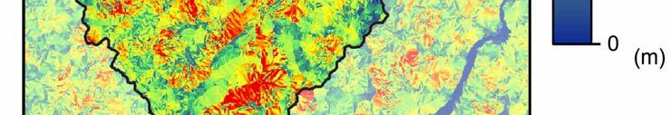
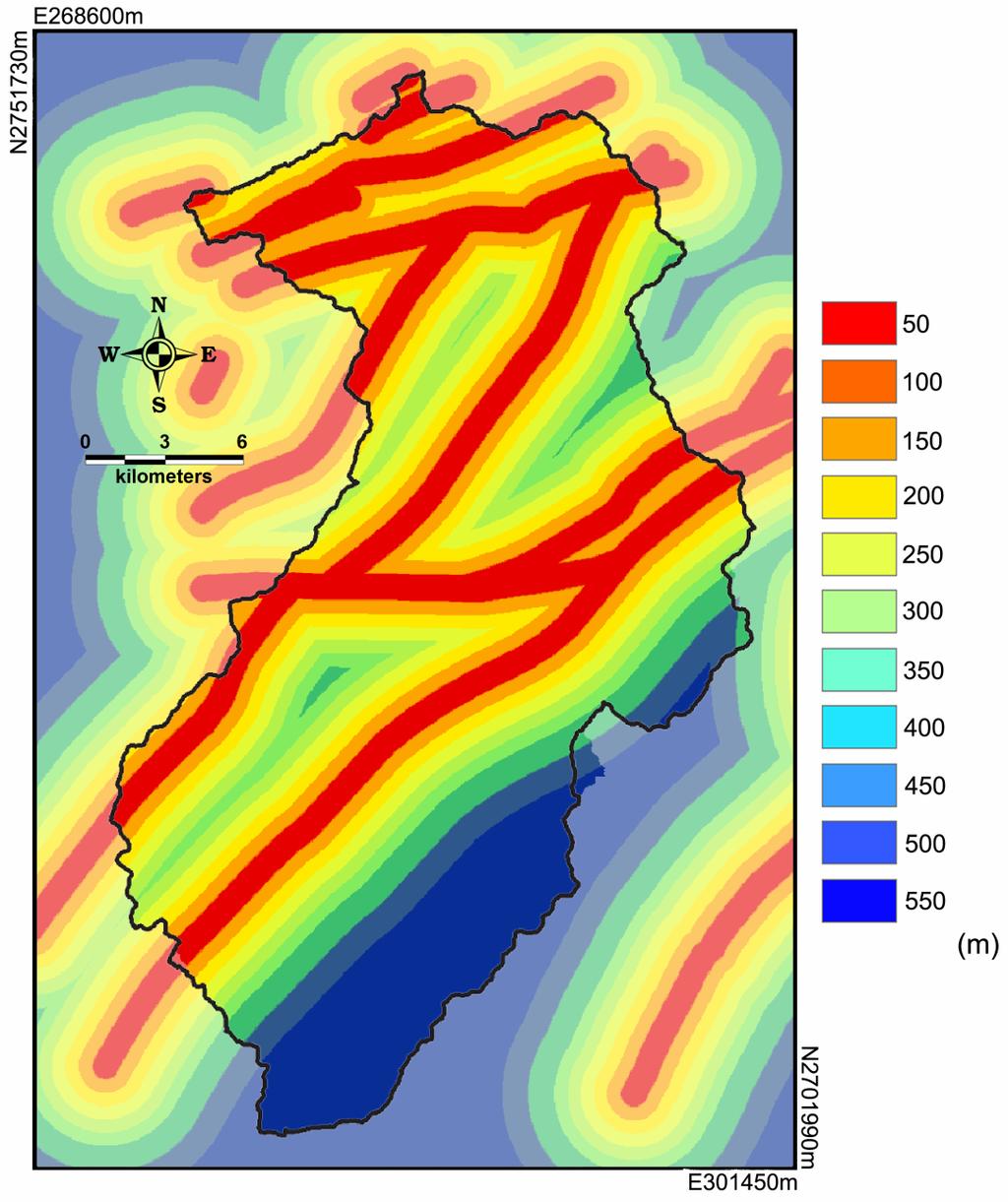
11 5m x 5m DEM Plunge Pool for extraction of topographic factors and wetness index Shihmen Dam Shihmen Reservoir Tahan Creek Source of data: Central Geological Survey, Taiwan 11

12 Geologic Map for extraction of lithology and fault lines SCALE:1/50,000 Source of data: Central Geological Survey, Taiwan 12

13 SPOT image taken prior to Typhoon Aere for extraction of vegetation covers 13
14 Rainfall Records for processing maximum rainfall intensity for triggering factor of landslides LEGEND Catchment area Gauge station, WRA Gauge station, CWB 14
15 Data Processing Both multi-spectral (XS) and panchromatic (PAN) SPOT5 images were used. They were fused into a higher resolution (2.5m x 2.5m) false-color image for landslide interpretation. Multi-spectral image taken prior to typhoon Aere was used for calculation of normalized differential vegetation index (NDVI). Digital terrain model (DEM) of 5x5m resolution was corrected for erroneous data and filtered for noises, and then the DEM was reduced into a 10x10m resolution for further use. Geological map, rainfall data, NDVI, etc. are trnsfered into 10x10m grid data for further use. Slope gradient, slope aspect, slope height, etc. which are derived from DEM are also in 10x10m grid data format. Tools used are MapInfo vector GIS and EARDS Imagine raster GIS. 15
16 Preliminary Selection of Factors Lithology Slope gradient Slope aspect NDVI Topographic roughness Slope roughness Topographic curvatures Relative slope height Total slope height Distance to road Distance to fault Distance to river bend Distance to river head Wetness index Maximum rainfall intensity Total rainfall 16
17 Selection of Effective Factors Frequency 4% 3% 2% 1% Non-landslide Landslide D= % Slope, % Exp. Cum. Prob. P-P Plot Obs. Cum. Prob. Prob. of Failure 10% 8% 6% 4% 2% Probability of Failure Curve 0% Slpoe, % Portion of Landslide Success Rate Curve AUC= Portion of Area Visual inspection of frequency distribution of the two groups, and calculation of discriminator D. Test of normal distribution of the factor. Examination of probability of failure curve to see if landslide probability increases with the factor value. Examination of success rate curve to check the ability of interpreting landslides of the factor. Discriminator D j :, where, A j is average of landslide group, B j is average of non-landslide group, S Pj is pooled standard deviation of two groups, j indicates j th factor. 17
18 Effective Factors Selected The following factors are tested to be effective in interpreting landslides: Lithology Slope gradient Slope roughness Profile curvature Relative slope height Total slope height NDVI Wetness index Distance to fault Maximum rainfall intensity (triggering factor) 18


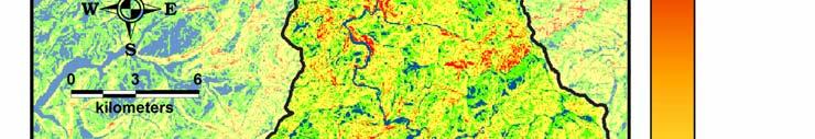


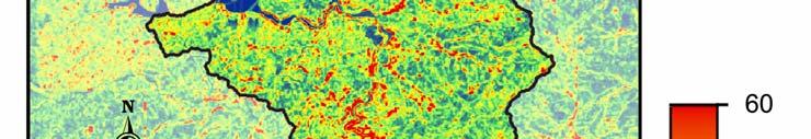

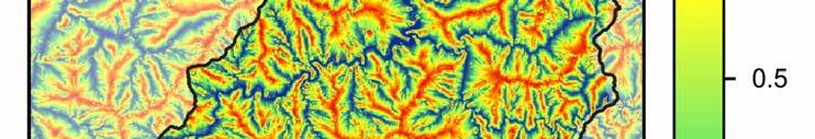
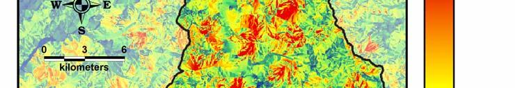
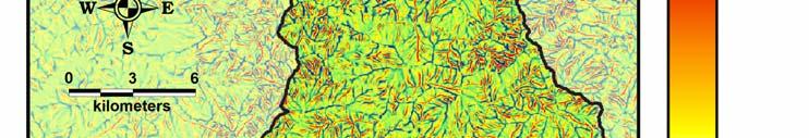
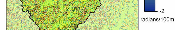
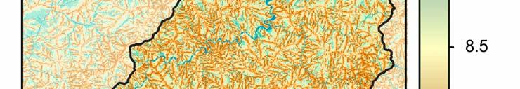
19 Effective Factors SLOPE SLOPE ROUGHNESS 19


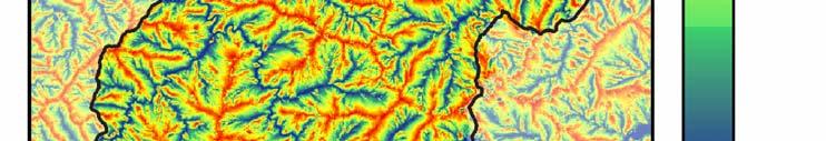


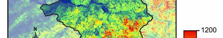

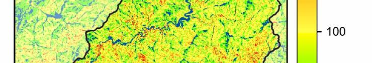
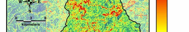
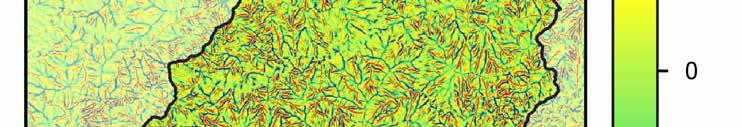
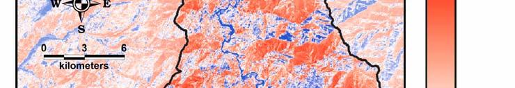
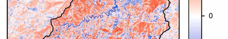
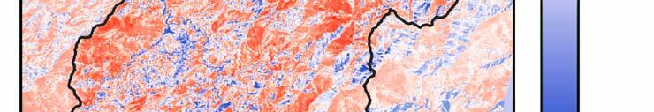
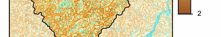
20 Effective Factors RELATIVE SLOPE HEIGHT TOTAL SLOPE HEIGHT 20

21 Schematic map showing the definition of slope terms A: Elevation of crest B: Horizontal distance to river C: Height relative to riverbed D: Elevation of toe E: Total slope height F: Height relative to crest G: Height relative to toe H: Horizontal distance to crest I: Horizontal distance to toe J: Horizontal distance between crest and toe K: Slope length Relative slope height = Slope height (height relative to toe) Total slope height 21


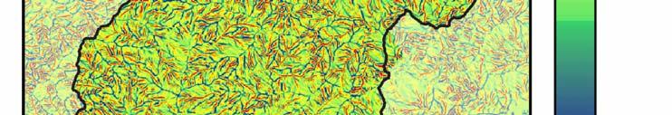


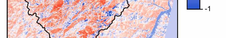

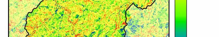
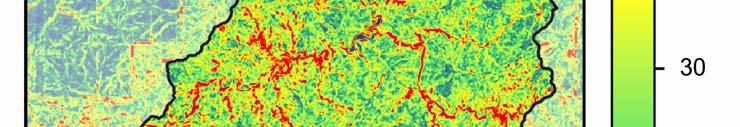
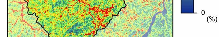
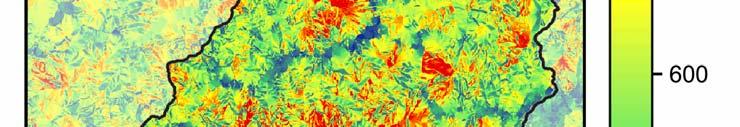
22 Effective Factors PROFILE CURVATURE NDVI 22


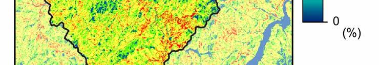
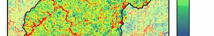
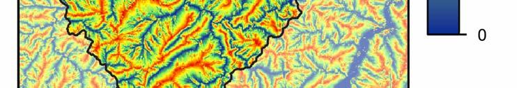
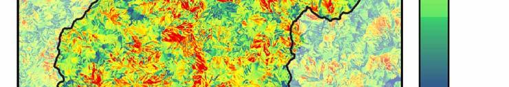
23 Effective Factors WETNESS INDEX DISTANCE TO FAULT 23


24 Effective Factors LITHOLOGY MAXIMUM HOURLY RAINFALL 24
25 Logistic Regression Data in the Shihmen Reservoir catchment area for shallow landslides triggered by typhoon Aere were used for the analysis. The data set from landslide group contains 38,403 cells, 20,000 cells were randomly selected for building the model and the other 18,403 cells were used for validation. A randomly selected non-landslide data set of similar size was used in the logistic regression and validation. p F F F F F F F ln = p F F F F F F Occurrence probability p is taken as susceptibility index in this study. F 1 : sandstone and shale unit, F 2 : indurate sandstone and shale unit, F 3 : argillite unit, F 4 : quartzite and argillite unit, F 5 : slope gradient, F 6 : NDVI, F 7 : slope roughness, F 8 : profile curvature, F 9 : total slope height, F 10 : relative slope height, F 11 : wetness index, F 12 : distance to a fault, F 13 : maximum rainfall intensity. 25
 1 λ 0.6403 0 0.2 0.4 0.6 0.8 1 Susceptibility Index, λ 1 Success Rate Curve Portion of Landslide 0.8 0.6 0.4 0.2 0 Logistic AUC=0.8561 0 0.2 0.4 0.6 0.8 1 Portion of Area 26")
26 Landslide Spatial Probability Maps Typhoon Aere Rainfall 100-year Return Period Rainfall 0.1 Probability of Failure, P ls P ls λ = ( ) 1 λ Susceptibility Index, λ 1 Success Rate Curve Portion of Landslide Logistic AUC= Portion of Area 26
27 Model Applications The landslide hazard model could be used for the prediction of future landslides providing a scenario rainfall distribution is given. The 100-year return period landslide hazard map could be used for general purposes, like for regional planning, engineering site selection and hazard mitigation policy making. The landslide hazard model could also be used for sediment prediction of a catchment area. 27
28 Sediment Prediction (1/3) From probability of landslide occurrence map, we may estimate shallow landslide area A sl as follow, A = ap sl ls i i where, P ls i is probability of failure at cell i, a is area of a cell; it is 100 m2 in this study. From spatial landslide probability map of typhoon Aere event, we can estimate landslide area to be 28,928,800m2, Actual landslide from the inventory is 2,872 landslides with a total area of 21,053,000m2. The difference indicates that mapping of the landslide inventory may have missed some landslides in shadows of the SPOT images. Furthermore, missing of small-scale landslides and deleting of repeated landslides in the event-based landslide inventory may also reduce the total area of landslide as compared to the prediction ones. 28
29 Sediment Prediction (2/3) We further adopted a soil-thickness prediction model from Chung (2008) as follow, h = ln S where, h is soil thickness (m),s is slope ( ). Inserting slope data into above equation, we can get soil thickness at each grid-cell in the study area and further estimate landslide volume V sl as follow, V = (494.29P P ln S ) sl lsi lsi i i Using the above equation, we could estimate landslide volume induced by typhoon Aere to be 25,510,700 m 3. Actual landslide volume using landslide area from inventory is 17,996,290 m3. Again, the difference is because of we have missed small-scale landslides, landslides in shadows and repeating landslides. 29
30 Sediment Prediction (3/3) To this step, we can successfully predict landslide location, area and volume in a drainage basin or catchment area using GIS. However, the amount of sediment yield in a catchment still requires estimation of soil erosion on the slope and sediment transportation in the stream. A distributed hydrological and sediment transport modeling should be further carried out so that sediment problem like that in the Shihmen Reservoir catchment area could be interpreted. GIS is a useful tool for managing and processing the model factors and also good for construction of a hazard map and application in regional planning, hazard mitigation, and sediments yield estimation. 30
31 Thanks for your attention! 31
Statistical Seismic Landslide Hazard Analysis: an Example from Taiwan
 Statistical Seismic Landslide Hazard Analysis: an Example from Taiwan Chyi-Tyi Lee Graduate Institute of Applied Geology, National Central University, Taiwan Seismology Forum 27: Natural Hazards and Surface
Date : 2018/10/18 Presenter : Yu-Cheng Tai Advisor : Chyi-Tyi Lee
 The exploration of the relation among landslide susceptibility, probability of failure and rainfall by using independent events - Lanyang catchment and neighboring area for a case study Date : 2018/10/18
Landslide Susceptibility, Hazard, and Risk Assessment. Twin Hosea W. K. Advisor: Prof. C.T. Lee
 Landslide Susceptibility, Hazard, and Risk Assessment Twin Hosea W. K. Advisor: Prof. C.T. Lee Date: 2018/05/24 1 OUTLINE INTRODUCTION LANDSLIDE HAZARD ASSESSTMENT LOGISTIC REGRESSION IN LSA STUDY CASE
Multi-stage Statistical Landslide Hazard Analysis: Earthquake-Induced Landslides
 Multi-stage Statistical Landslide Hazard Analysis: Earthquake-Induced Landslides Chyi-Tyi Lee Abstract Landslides are secondary or induced features, whose recurrence is controlled by the repetition of
Assessment of the Incidence of Landslides Using Numerical Information
 PAPER Assessment of the Incidence of Landslides Using Numerical Information Atsushi HASEGAWA Takehiro OHTA, Dr. Sci. Assistant Senior Researcher, Senior Researcher, Laboratory Head, Geology Laboratory,
ON THE CORRELATION OF SEDIMENTATION AND LANDSLIDES IN WU RIVER CATCHMENT INFLUENCED BY THE 1999 CHI-CHI EARTHQUAKE
 ON THE CORRELATION OF SEDIMENTATION AND LANDSLIDES IN WU RIVER CATCHMENT INFLUENCED BY THE 1999 CHI-CHI EARTHQUAKE Keh-Jian Shou 1*, Li-Yuan Fei 2, Jiin-Fa Lee 2, Cheng-Yueh Wei 2, Chiu-Ching Wu 1, Chia-Yue
Re-Evaluation of Factors Controlling Landslides Triggered by the 1999 Chi Chi Earthquake
 Re-Evaluation of Factors Controlling Landslides Triggered by the 1999 Chi Chi Earthquake Chyi-Tyi Lee 22 Abstract Landslides triggered by the 1999 Chi Chi earthquake were re-mapped from high-resolution
Practical reliability approach to urban slope stability
 University of Wollongong Research Online Faculty of Engineering - Papers (Archive) Faculty of Engineering and Information Sciences 2011 Practical reliability approach to urban slope stability R. Chowdhury
Hendra Pachri, Yasuhiro Mitani, Hiro Ikemi, and Ryunosuke Nakanishi
 21 2nd International Conference on Geological and Civil Engineering IPCBEE vol. 8 (21) (21) IACSIT Press, Singapore DOI: 1.7763/IPCBEE. 21. V8. 2 Relationships between Morphology Aspect and Slope Failure
SPECIFIC DEGRADATION AND RESERVOIR SEDIMENTATION. By Renee Vandermause & Chun-Yao Yang
 SPECIFIC DEGRADATION AND RESERVOIR SEDIMENTATION By Renee Vandermause & Chun-Yao Yang Outline Sediment Degradation - Erosion vs Sediment Yield - Sediment Yield - Methods for estimation - Defining Sediment
Coupling TRIGRS and TOPMODEL in shallow landslide prediction. 1 Presenter: 王俊皓 Advisor: 李錫堤老師 Date: 2016/10/13
 Coupling TRIGRS and TOPMODEL in shallow landslide prediction 1 Presenter: 王俊皓 Advisor: 李錫堤老師 Date: 016/10/13 Outline Introduction Literature review Methodology Pre-result Future work Introduction 3 Motivation
Using Weather and Climate Information for Landslide Prevention and Mitigation
 Using Weather and Climate Information for Landslide Prevention and Mitigation Professor Roy C. Sidle Disaster Prevention Research Institute Kyoto University, Japan International Workshop on Climate and
Preparing Landslide Inventory Maps using Virtual Globes
 Introduction: A landslide is the movement of a mass of rock, debris, or earth down a slope, under the influence of gravity. Landslides can be caused by different phenomena, including intense or prolonged
Landslide Hazard Assessment Methodologies in Romania
 A Scientific Network for Earthquake, Landslide and Flood Hazard Prevention SciNet NatHazPrev Landslide Hazard Assessment Methodologies in Romania In the literature the terms of susceptibility and landslide
Landslide Hazard Analysis at Jelapangof North-South Expressway in Malaysia Using High Resolution Airborne LiDAR Data
 Landslide Hazard Analysis at Jelapangof North-South Expressway in Malaysia Using High Resolution Airborne LiDAR Data NORBAZLAN MOHD YUSOF GEOSPATIAL WORLD FORUM 2015 Geospatial World Forum, Portugal 25-29
Natural Terrain Risk Management in Hong Kong
 Natural Terrain Risk Management in Hong Kong Nick Koor Senior Lecturer in Engineering Geology School of Earth and Environmental Sciences Slope failures in Hong Kong Man-made Slope Failure - 300 landslides
Landslide Susceptibility Mapping by Using Logistic Regression Model with Neighborhood Analysis: A Case Study in Mizunami City
 Int. J. of GEOMATE, Dec. Int. 2011, J. of Vol. GEOMATE, 1, No. 2 (Sl. Dec. No. 2011, 2), pp. Vol. 99-104 1, No. 2 (Sl. No. 2), pp. 99-104 Geotec., Const. Mat. and Env., ISSN:2186-2982(P), 2186-2990(O),
A Roundup of Recent Debris Flow Events in Taiwan
 2015 International Workshop on Typhoon and Flood APEC Experience Sharing on Hazardous Weather Events and Risk Management A Roundup of Recent Debris Flow Events in Taiwan Hsiao-Yuan(Samuel) Yin Ph.D. sammya@mail.swcb.gov.tw
2014 Summer Training Courses on Slope Land Disaster Reduction Hydrotech Research Institute, National Taiwan University, Taiwan August 04-15, 2014
 Final Project Report 2014 Summer Training Courses on Slope Land Disaster Reduction Hydrotech Research Institute, National Taiwan University, Taiwan August 04-15, 2014 Landslides in Mt. Umyeon Susceptibility
PRELIMINARY INVESTIGATION ON THE FAILURE OF THE BA-LING CHECK DAM IN THE WATERSHED OF SHI-MEN RESERVOIR IN TAIWAN
 PRELIMINARY INVESTIGATION ON THE FAILURE OF THE BA-LING CHECK DAM IN THE WATERSHED OF SHI-MEN RESERVOIR IN TAIWAN Su-Chin Chen. 1 *, Yu-Hsan Chang 2, Ben-Kang Chen 3, Yi-Chuan Liu 4, Zheng-Yi Feng, 5*,
APPLICATION OF REMOTE SENSING & GIS ON LANDSLIDE HAZARD ZONE IDENTIFICATION & MANAGEMENT
 APPLICATION OF REMOTE SENSING & GIS ON LANDSLIDE HAZARD ZONE IDENTIFICATION & MANAGEMENT PRESENTED BY SUPRITI PRAMANIK M.TECH IN ENVIRONMENTAL SCIENCE AND TECHNOLOGY NIT,DURGAPUR 25-04-2015 1 INTRODUCTION
Application of high-resolution (10 m) DEM on Flood Disaster in 3D-GIS
 DEM on Flood Disaster in 3D-GIS") Risk Analysis V: Simulation and Hazard Mitigation 263 Application of high-resolution (10 m) DEM on Flood Disaster in 3D-GIS M. Mori Department of Information and Computer Science, Kinki University, Japan
Risk Analysis V: Simulation and Hazard Mitigation 263 Application of high-resolution (10 m) DEM on Flood Disaster in 3D-GIS M. Mori Department of Information and Computer Science, Kinki University, Japan
INTRODUCTION. Climate
 INTRODUCTION Climate Landslides are serious natural disasters in many parts of the world. Since the past 30 years, rainfall triggered landslides and debris flows had been one of the natural disasters of
Sediment yield estimation from a hydrographic survey: A case study for the Kremasta reservoir, Western Greece
 Sediment yield estimation from a hydrographic survey: A case study for the Kremasta reservoir, Western Greece 5 th International Conference Water Resources Management in the Era of Transition,, Athens,
GIS model & modeling
 GIS model & modeling Model : a simplified representation of a phenomenon or a system. GIS modeling : the use of GIS in the process of building models with spatial data. Basic requirement in modeling :
International Symposium on Natural Disaster Mitigation. Local vulnerability assessment of landslides and debris flows
 International Symposium on Natural Disaster Mitigation of landslides and debris flows Lessons learnt from Cam Pha town and Van Don district, Quang Ninh province, Vietnam Nguyen Quoc Phi Faculty of Environment
A METHODOLOGY FOR ASSESSING EARTHQUAKE-INDUCED LANDSLIDE RISK. Agency for the Environmental Protection, ITALY (
 A METHODOLOGY FOR ASSESSING EARTHQUAKE-INDUCED LANDSLIDE RISK Roberto W. Romeo 1, Randall W. Jibson 2 & Antonio Pugliese 3 1 University of Urbino, ITALY (e-mail: rwromeo@uniurb.it) 2 U.S. Geological Survey
Dan Miller + Kelly Burnett, Kelly Christiansen, Sharon Clarke, Lee Benda. GOAL Predict Channel Characteristics in Space and Time
 Broad-Scale Models Dan Miller + Kelly Burnett, Kelly Christiansen, Sharon Clarke, Lee Benda GOAL Predict Channel Characteristics in Space and Time Assess Potential for Fish Use and Productivity Assess
Response on Interactive comment by Anonymous Referee #1
 Response on Interactive comment by Anonymous Referee #1 Sajid Ali First, we would like to thank you for evaluation and highlighting the deficiencies in the manuscript. It is indeed valuable addition and
A GIS View of Hydrology
 Quantitative Elements of Hydrology A GIS View of Hydrology Contact information: Jack Hermance Environmental Geophysics/Hydrology Department of Geological Sciences Brown University, Providence, RI 02912-1846
Debris flow: categories, characteristics, hazard assessment, mitigation measures. Hariklia D. SKILODIMOU, George D. BATHRELLOS
 Debris flow: categories, characteristics, hazard assessment, mitigation measures Hariklia D. SKILODIMOU, George D. BATHRELLOS Natural hazards: physical phenomena, active in geological time capable of producing
DAMAGE DETECTION OF THE 2008 SICHUAN, CHINA EARTHQUAKE FROM ALOS OPTICAL IMAGES
 DAMAGE DETECTION OF THE 2008 SICHUAN, CHINA EARTHQUAKE FROM ALOS OPTICAL IMAGES Wen Liu, Fumio Yamazaki Department of Urban Environment Systems, Graduate School of Engineering, Chiba University, 1-33,
Landslide Susceptibility Mapping Using Logistic Regression in Garut District, West Java, Indonesia
 Landslide Susceptibility Mapping Using Logistic Regression in Garut District, West Java, Indonesia N. Lakmal Deshapriya 1, Udhi Catur Nugroho 2, Sesa Wiguna 3, Manzul Hazarika 1, Lal Samarakoon 1 1 Geoinformatics
Crystal Moncada. California State University San Bernardino. January- July Brett R. Goforth- Department of Geography and Environmental Studies
 A Geographical Information System (GIS) Based Evaluation of Landslide Susceptibility Mapped on the Harrison Mountain Quadrangle of the Santa Ana River Watershed Crystal Moncada California State University
Understanding disaster risk ~ Lessons from 2009 Typhoon Morakot, Southern Taiwan
 Understanding disaster risk ~ Lessons from 2009 Typhoon Morakot, Southern Taiwan Wen Chi Lai, Chjeng-Lun Shieh Disaster Prevention Research Center, National Cheng-Kung University 1. Introduction 08/10
13 Watershed Delineation & Modeling
 Module 4 (L12 - L18): Watershed Modeling Standard modeling approaches and classifications, system concept for watershed modeling, overall description of different hydrologic processes, modeling of rainfall,
Surface Processes Focus on Mass Wasting (Chapter 10)
") Surface Processes Focus on Mass Wasting (Chapter 10) 1. What is the distinction between weathering, mass wasting, and erosion? 2. What is the controlling force in mass wasting? What force provides resistance?
Surface Processes Focus on Mass Wasting (Chapter 10) 1. What is the distinction between weathering, mass wasting, and erosion? 2. What is the controlling force in mass wasting? What force provides resistance?
A distributed runoff model for flood prediction in ungauged basins
 Predictions in Ungauged Basins: PUB Kick-off (Proceedings of the PUB Kick-off meeting held in Brasilia, 2 22 November 22). IAHS Publ. 39, 27. 267 A distributed runoff model for flood prediction in ungauged
Topographical Change Monitoring for Susceptible Landslide Area Determination by Using Multi-Date Digital Terrain Models and LiDAR
 Topographical Change Monitoring for Susceptible Landslide Area Determination by Using Multi-Date Digital Terrain Models and Chanist PRASERTBURANAKUL 1, Parkorn SUWANICH 2, Kanchana NAKHAPAKORN 3, and Sukit
LANDSLIDE SUSCEPTIBILITY MAPPING USING INFO VALUE METHOD BASED ON GIS
 LANDSLIDE SUSCEPTIBILITY MAPPING USING INFO VALUE METHOD BASED ON GIS ABSTRACT 1 Sonia Sharma, 2 Mitali Gupta and 3 Robin Mahajan 1,2,3 Assistant Professor, AP Goyal Shimla University Email: sonia23790@gmail.com
A GIS-based statistical model for landslide susceptibility mapping: A case study in the Taleghan watershed, Iran
 Biological Forum An International Journal 7(2): 862-868(2015) ISSN No. (Print): 0975-1130 ISSN No. (Online): 2249-3239 A GIS-based statistical model for landslide susceptibility mapping: A case study in
HYDRAULIC MODELLING OF NENJIANG RIVER FLOODPLAIN IN NORTHEAST CHINA
 HYDRAULIC MODELLING OF NENJIANG RIVER FLOODPLAIN IN NORTHEAST CHINA Xiao Fei MEE08181 Supervisor: A.W. Jayawardena ABSTRACT In 1998, the worst flood recorded for over 200 years hit the Songhua River Basin
USING GIS CARTOGRAPHIC MODELING TO ANALYSIS SPATIAL DISTRIBUTION OF LANDSLIDE SENSITIVE AREAS IN YANGMINGSHAN NATIONAL PARK, TAIWAN
 CO-145 USING GIS CARTOGRAPHIC MODELING TO ANALYSIS SPATIAL DISTRIBUTION OF LANDSLIDE SENSITIVE AREAS IN YANGMINGSHAN NATIONAL PARK, TAIWAN DING Y.C. Chinese Culture University., TAIPEI, TAIWAN, PROVINCE
THE 3D SIMULATION INFORMATION SYSTEM FOR ASSESSING THE FLOODING LOST IN KEELUNG RIVER BASIN
 THE 3D SIMULATION INFORMATION SYSTEM FOR ASSESSING THE FLOODING LOST IN KEELUNG RIVER BASIN Kuo-Chung Wen *, Tsung-Hsing Huang ** * Associate Professor, Chinese Culture University, Taipei **Master, Chinese
GIS feature extraction tools in diverse landscapes
 CE 394K.3 GIS in Water Resources GIS feature extraction tools in diverse landscapes Final Project Anna G. Kladzyk M.S. Candidate, Expected 2015 Department of Environmental and Water Resources Engineering
ENGRG Introduction to GIS
 ENGRG 59910 Introduction to GIS Michael Piasecki March 17, 2014 Lecture 08: Terrain Analysis Outline: Terrain Analysis Earth Surface Representation Contour TIN Mass Points Digital Elevation Models Slope
International Journal of Innovative Research in Advanced Engineering (IJIRAE) ISSN: Issue 08, Volume 3 (August 2016)
 ISSN: Issue 08, Volume 3 (August 2016)") GIS-3D Analysis of Susceptibility Landslide Disaster in Upstream Area of Jeneberang River Watershed, South Sulawesi, Indonesia Yoenus Osman *, Ramli Rahim **, Saleh Pallu **, Sumbangan Baja ** * Doctorate
GIS-3D Analysis of Susceptibility Landslide Disaster in Upstream Area of Jeneberang River Watershed, South Sulawesi, Indonesia Yoenus Osman *, Ramli Rahim **, Saleh Pallu **, Sumbangan Baja ** * Doctorate
Improvement of Hazard Assessment and Management in the Philippines
 Improvement of Hazard Assessment and Management in the Philippines (2014 Summer Training Course for Slope Land Disaster Reduction) Ian Alejandrino (Philippines) Nguyen Manh Hieu (Vietnam) Presentation
ENGRG Introduction to GIS
 ENGRG 59910 Introduction to GIS Michael Piasecki November 17, 2017 Lecture 11: Terrain Analysis Outline: Terrain Analysis Earth Surface Representation Contour TIN Mass Points Digital Elevation Models Slope
Geo 327G Semester Project. Landslide Suitability Assessment of Olympic National Park, WA. Fall Shane Lewis
 Geo 327G Semester Project Landslide Suitability Assessment of Olympic National Park, WA Fall 2011 Shane Lewis 1 I. Problem Landslides cause millions of dollars of damage nationally every year, and are
Pierce Cedar Creek Institute GIS Development Final Report. Grand Valley State University
 Pierce Cedar Creek Institute GIS Development Final Report Grand Valley State University Major Goals of Project The two primary goals of the project were to provide Matt VanPortfliet, GVSU student, the
DEM-based Ecological Rainfall-Runoff Modelling in. Mountainous Area of Hong Kong
 DEM-based Ecological Rainfall-Runoff Modelling in Mountainous Area of Hong Kong Qiming Zhou 1,2, Junyi Huang 1* 1 Department of Geography and Centre for Geo-computation Studies, Hong Kong Baptist University,
Assessment of regional rainfall-induced landslides using 3S-based hydro-geological model
 Landslides and Engineered Slopes Chen et al. (eds) 2008 Taylor & Francis Group, London, ISBN 978-0-415-41196-7 Assessment of regional rainfall-induced landslides using 3S-based hydro-geological model C.H.
SPATIAL MODELS FOR THE DEFINITION OF LANDSLIDE SUSCEPTIBILITY AND LANDSLIDE HAZARD. J.L. Zêzere Centre of Geographical Studies University of Lisbon
 SPATIAL MODELS FOR THE DEFINITION OF LANDSLIDE SUSCEPTIBILITY AND LANDSLIDE HAZARD J.L. Zêzere Centre of Geographical Studies University of Lisbon CONCEPTUAL MODEL OF LANDSLIDE RISK Dangerous Phenomena
3D Slope Stability Analysis for Slope Failure Probability in Sangun mountainous, Fukuoka Prefecture, Japan
 3D Slope Stability Analysis for Slope Failure Probability in Sangun mountainous, Fukuoka Prefecture, Japan Hendra PACHRI (1), Yasuhiro MITANI (1), Hiro IKEMI (1), and Wenxiao JIANG (1) (1) Graduate School
2013 Esri Europe, Middle East and Africa User Conference October 23-25, 2013 Munich, Germany
 2013 Esri Europe, Middle East and Africa User Conference October 23-25, 2013 Munich, Germany Environmental and Disaster Management System in the Valles Altos Region in Carabobo / NW-Venezuela Prof.Dr.habil.Barbara
USING 3D GIS TO ASSESS ENVIRONMENTAL FLOOD HAZARDS IN MINA
 King Fahd University of Petroleum & Minerals College of Environmental Design Geographical Information system USING 3D GIS TO ASSESS ENVIRONMENTAL FLOOD HAZARDS IN MINA Prepared by : Ali AL-Zahrani OUTLINE
INTERNATIONAL JOURNAL OF GEOMATICS AND GEOSCIENCES Volume 1, No 1, 2010
 An Integrated Approach with GIS and Remote Sensing Technique for Landslide Hazard Zonation S.Evany Nithya 1 P. Rajesh Prasanna 2 1. Lecturer, 2. Assistant Professor Department of Civil Engineering, Anna
Background. Points of Discussion. Hydrographic Models
 Airborne Laser Remote Sensing Technology: Providing Essential Hydrologic Information in the 21 st Century Warwick Hadley, Optech Incorporated Presented by: Warwick Hadley Sales Manager, Middle East and
Application of support vector machines in landslide susceptibility assessment for the Hoa Binh province (Vietnam) with kernel functions analysis
 with kernel functions analysis") International Environmental Modelling and Software Society (iemss) 2012 International Congress on Environmental Modelling and Software Managing Resources of a Limited Planet, Sixth Biennial Meeting, Leipzig,
International Environmental Modelling and Software Society (iemss) 2012 International Congress on Environmental Modelling and Software Managing Resources of a Limited Planet, Sixth Biennial Meeting, Leipzig,
Tarbela Dam in Pakistan. Case study of reservoir sedimentation
 Tarbela Dam in Pakistan. HR Wallingford, Wallingford, UK Published in the proceedings of River Flow 2012, 5-7 September 2012 Abstract Reservoir sedimentation is a main concern in the Tarbela reservoir
STATISTICAL MODELING OF LANDSLIDE HAZARD USING GIS
 STATISTICAL MODELING OF LANDSLIDE HAZARD USING GIS By Peter V. Gorsevski, Department of Forest Resources College of Natural Resources University of Idaho; Randy B. Foltz, U.S. Forest Service, Rocky Mountain
Floodplain modeling. Ovidius University of Constanta (P4) Romania & Technological Educational Institute of Serres, Greece
 Romania & Technological Educational Institute of Serres, Greece") Floodplain modeling Ovidius University of Constanta (P4) Romania & Technological Educational Institute of Serres, Greece Scientific Staff: Dr Carmen Maftei, Professor, Civil Engineering Dept. Dr Konstantinos
Floodplain modeling Ovidius University of Constanta (P4) Romania & Technological Educational Institute of Serres, Greece Scientific Staff: Dr Carmen Maftei, Professor, Civil Engineering Dept. Dr Konstantinos
Investigation, assessment and warning zonation for landslides in the mountainous regions of Vietnam
 Investigation, assessment and warning zonation for landslides in the mountainous regions of Vietnam (State-Funded Landslide Project SFLP) Dr. Eng. Le Quoc Hung Add: 67 Chien Thang Street, Ha Dong District,
Modeling the Change of Mangrove Forests in Irrawaddy Delta, South Myanmar
 International Journal of Sciences: Basic and Applied Research (IJSBAR) ISSN 2307-4531 (Print & Online) http://gssrr.org/index.php?journal=journalofbasicandapplied ---------------------------------------------------------------------------------------------------------------------------
Rapid Hazard Assessment of Heavy Rainfall Triggered Landslide Dams A Review
 Rapid Hazard Assessment of Heavy Rainfall Triggered Landslide Dams A Review Focus on the developed technologies in Taiwan J. J. Dong Graduate Institute of Applied Geology, National Central University,
Eagle Creek Post Fire Erosion Hazard Analysis Using the WEPP Model. John Rogers & Lauren McKinney
 Eagle Creek Post Fire Erosion Hazard Analysis Using the WEPP Model John Rogers & Lauren McKinney Columbia River Gorge at Risk: Using LiDAR and GIS-based predictive modeling for regional-scale erosion susceptibility
Need of Proper Development in Hilly Urban Areas to Avoid
 Need of Proper Development in Hilly Urban Areas to Avoid Landslide Hazard Dr. Arvind Phukan, P.E. Cosultant/Former Professor of Civil Engineering University of Alaska, Anchorage, USA RI District Governor
ESRI GIS For Mining Seminar, 10 th August, 2016, Nairobi, Kenya. Spatial DATA Solutions for Mining
 ESRI GIS For Mining Seminar, 10 th August, 2016, Nairobi, Kenya Spatial DATA Solutions for Mining Spatial Data Solutions for Mining Spatial - Data that identifies the geographic location of features &
FAILURES IN THE AMAZON RIVERBANKS, IQUITOS, PERU
 FAILURES IN THE AMAZON RIVERBANKS, IQUITOS, PERU A.Carrillo-Gil University of Engineering & A.Carrillo Gil S.A.,Consulting Engineering,Lima,Peru L. Dominguez University of Engineering,Lima & The Maritime
GEOMORPHOLOGY APPROACH IN LANDSLIDE VULNERABILITY, TANJUNG PALAS TENGAH, EAST KALIMANTAN, INDONESIA
 GEOMORPHOLOGY APPROACH IN LANDSLIDE VULNERABILITY, TANJUNG PALAS TENGAH, EAST KALIMANTAN, INDONESIA *Twin H. W. Kristyanto Geology Study Program, FMIPA UI, Universitas Indonesia *Author for Correspondence:
MODULE 7 LECTURE NOTES 5 DRAINAGE PATTERN AND CATCHMENT AREA DELINEATION
 MODULE 7 LECTURE NOTES 5 DRAINAGE PATTERN AND CATCHMENT AREA DELINEATION 1. Introduction Topography of the river basin plays an important role in hydrologic modelling, by providing information on different
8 Current Issues and Research on Sediment Movement in the River Catchments of Japan
 8 Current Issues and Research on Sediment Movement in the River Catchments of Japan YUTAKA ICHIKAWA INTRODUCTION Prediction of sediment movement is one of the challenging tasks in water-related research.
Dr. S.SURIYA. Assistant professor. Department of Civil Engineering. B. S. Abdur Rahman University. Chennai
 Hydrograph simulation for a rural watershed using SCS curve number and Geographic Information System Dr. S.SURIYA Assistant professor Department of Civil Engineering B. S. Abdur Rahman University Chennai
A SIMPLE GIS METHOD FOR OBTAINING FLOODED AREAS
 A SIMPLE GIS METHOD FOR OBTAINING FLOODED AREAS ROMAN P., I. 1, OROS C., R. 2 ABSTRACT. A simple GIS method for obtaining flooded areas. This paper presents a method for obtaining flooded areas near to
Gully erosion and associated risks in the Tutova basin Moldavian Plateau
 Landform Analysis, Vol. 17: 193 197 (2011) Gully erosion and associated risks in the Tutova basin Moldavian Plateau University Alexandru Ioan Cuza of Iasi, Department of Geography, Romania, e-mail: catiul@yahoo.com
Utilization of Global Map for Societal Benefit Areas
 Utilization of Global Map for Societal Benefit Areas The Fourth GEOSS AP Symposium Bali Indonesia, 11th March 2010 Shuhei Kojima Geographical Survey Institute Ministry of Land, Infrastructure, Transport
Sediment Disasters and Mass Movement (SD&M 2 ) NATIONAL DISASTER MANAGEMENT RESEARCH INSTITUTE
 NATIONAL DISASTER MANAGEMENT RESEARCH INSTITUTE") Sediment Disasters and Mass Movement (SD&M 2 ) Contents Outline of SD&M 2 Major outcomes Issues and conclusions Prologue Mass movement in Ulsan, Korea by Typhoon CHABA on Oct. 5. Outline of SD&M 2 Activities
Sediment Disasters and Mass Movement (SD&M 2 ) Contents Outline of SD&M 2 Major outcomes Issues and conclusions Prologue Mass movement in Ulsan, Korea by Typhoon CHABA on Oct. 5. Outline of SD&M 2 Activities
PROANA A USEFUL SOFTWARE FOR TERRAIN ANALYSIS AND GEOENVIRONMENTAL APPLICATIONS STUDY CASE ON THE GEODYNAMIC EVOLUTION OF ARGOLIS PENINSULA, GREECE.
 PROANA A USEFUL SOFTWARE FOR TERRAIN ANALYSIS AND GEOENVIRONMENTAL APPLICATIONS STUDY CASE ON THE GEODYNAMIC EVOLUTION OF ARGOLIS PENINSULA, GREECE. Spyridoula Vassilopoulou * Institute of Cartography
EMERGENCY PLANNING IN NORTHERN ALGERIA BASED ON REMOTE SENSING DATA IN RESPECT TO TSUNAMI HAZARD PREPAREDNESS
 EMERGENCY PLANNING IN NORTHERN ALGERIA BASED ON REMOTE SENSING DATA IN RESPECT TO TSUNAMI HAZARD PREPAREDNESS Barbara Theilen-Willige Technical University of Berlin, Institute of Applied Geosciences Department
CR AAO Bridge. Dead River Flood & Natural Channel Design. Mitch Koetje Water Resources Division UP District
 CR AAO Bridge Dead River Flood & Natural Channel Design Mitch Koetje Water Resources Division UP District Old County Road AAO Bridge Map courtesy of Marquette County Silver Lake Basin McClure Basin
Bias correction of Dynamic Downscaled Typhoons Rainfall Data for Hydrological Applications
 Bias correction of Dynamic Downscaled Typhoons Rainfall Data for Hydrological Applications National Science and Technology Center for Disaster Reduction Dr. Yuan-Fong Su 27 May 2015 2015 International
GEOMORPHIC CHANGES OF A LANDSLIDE DAM BY OVERTOPPING EROSION
 DOI: 10.4408/IJEGE.2011-03.B-087 GEOMORPHIC CHANGES OF A LANDSLIDE DAM BY OVERTOPPING EROSION K. Yoshino (*), T. Uchida (*), T. shimizu (*) & K. Tamura (*) (*) Incorporated Administrative Agency, Public
Geospatial Approach for Delineation of Landslide Susceptible Areas in Karnaprayag, Chamoli district, Uttrakhand, India
 Geospatial Approach for Delineation of Landslide Susceptible Areas in Karnaprayag, Chamoli district, Uttrakhand, India Ajay Kumar Sharma & Anand Mohan Singh Overview Landslide - movement of a mass of rock,
Soil Erosion Calculation using Remote Sensing and GIS in Río Grande de Arecibo Watershed, Puerto Rico
 Soil Erosion Calculation using Remote Sensing and GIS in Río Grande de Arecibo Watershed, Puerto Rico Alejandra M. Rojas González Department of Civil Engineering University of Puerto Rico at Mayaguez.
GIS-aided Statistical Landslide Susceptibility Modeling And Mapping Of Antipolo Rizal (Philippines)
") IOP Conference Series: Earth and Environmental Science PAPER OPEN ACCESS GIS-aided Statistical Landslide Susceptibility Modeling And Mapping Of Antipolo Rizal (Philippines) To cite this article: A J Dumlao
IOP Conference Series: Earth and Environmental Science PAPER OPEN ACCESS GIS-aided Statistical Landslide Susceptibility Modeling And Mapping Of Antipolo Rizal (Philippines) To cite this article: A J Dumlao
Australian Journal of Basic and Applied Sciences. Landslide Hazard Mapping with New Topographic Factors: A Study Case of Penang Island, Malaysia
 Australian Journal of Basic and Applied Sciences, 8(4) Special 014, Pages: 387-39 AENSI Journals Australian Journal of Basic and Applied Sciences ISSN:1991-8178 Journal home page: www.ajbasweb.com Landslide
STREAM MORPHOLOGICAL ANALYSIS BY AIRBORNE LASER ALTIMETRY AND FRACTAL DIMENSION
 STREAM MORPHOLOGICAL ANALYSIS BY AIRBORNE LASER ALTIMETRY AND FRACTAL DIMENSION Mon-Shieh Yang 1* Ming-Chee Wu 2 and Jin-King Liu 3 1 Department of Earth Sciences, National Cheng Kung University, No.1
BASIC DETAILS. Morphometric features for landslide zonation A case study for Ooty Mettupalayam highway
 BASIC DETAILS Paper reference number : MWF PN 121 Title of the paper Name of the Presenter Author affiliation Mailing address Email address : Extraction of Topographic and Morphometric features for landslide
GIS AND REMOTE SENSING FOR GEOHAZARD ASSESSMENT AND ENVIRONMENTAL IMPACT EVALUATION OF MINING ACTIVITIES AT QUY HOP, NGHE AN, VIETNAM
 GIS AND REMOTE SENSING FOR GEOHAZARD ASSESSMENT AND ENVIRONMENTAL IMPACT EVALUATION OF MINING ACTIVITIES AT QUY HOP, NGHE AN, VIETNAM QuocPhi Nguyen 1, Phuong Nguyen 1, ThiHoa Nguyen 2 and TienPhu Nguyen
Modeling Great Britain s Flood Defenses. Flood Defense in Great Britain. By Dr. Yizhong Qu
 Modeling Great Britain s Flood Defenses AIRCurrents Editor s note: AIR launched its Inland Flood Model for Great Britain in December 2008. The hazard module captures the physical processes of rainfall-runoff
2014 Summer training course for slope land disaster reduction Taipei, Taiwan, Aug
 MINISTRY OF SCIENCE AND TECHNOLOGY HYDROTECH RESEARCH INSTITUTE MINISTRY OF NATURAL RESOURCES AND ENVIRONMENT VIETNAM INSTITUTE OF GEOSCIENCES AND MINERAL RESOURCES (VIGMR) 2014 Summer training course
Landslide Susceptibility in Tryon State Park, Oregon
 1 Landslide Susceptibility in Tryon State Park, Oregon Tracy E. Handrich 1 1 Geology Department, Portland State University, P.O. Box 751, Portland, Oregon, 97207 ABSTRACT LIDAR and topographic data were
7.1 INTRODUCTION 7.2 OBJECTIVE
 7 LAND USE AND LAND COVER 7.1 INTRODUCTION The knowledge of land use and land cover is important for many planning and management activities as it is considered as an essential element for modeling and
Classification of Erosion Susceptibility
 GEO327G: GIS & GPS Applications in Earth Sciences Classification of Erosion Susceptibility Denali National Park, Alaska Zehao Xue 12 3 2015 2 TABLE OF CONTENTS 1 Abstract... 3 2 Introduction... 3 2.1 Universal
Down-stream process transition (f (q s ) = 1)
 = 1)") Down-stream process transition (f (q s ) = 1) Detachment Limited S d >> S t Transport Limited Channel Gradient (m/m) 10-1 Stochastic Variation { Detachment Limited Equilibrium Slope S d = k sd A -θ d S
Down-stream process transition (f (q s ) = 1) Detachment Limited S d >> S t Transport Limited Channel Gradient (m/m) 10-1 Stochastic Variation { Detachment Limited Equilibrium Slope S d = k sd A -θ d S
Calculating the suspended sediment load of the Dez River
 Erosion and Sediment Transport Monitoring Programmes in River Basins (Proceedings of the Osio Symposium, August 1992). IAHS Publ. no. 210, 1992. 219 Calculating the suspended sediment load of the Dez River
EIT-Japan Symposium 2011 on Human Security Engineering
 EIT-Japan Symposium 2011 on Human Security Engineering 2011 Disastrous Landslides at Khao Panom, Krabi, Thailand Suttisak Soralump Geotechnical Engineering Research and Development Center (GERD) Faculty
3/8/17. #20 - Landslides: Mitigation and Case Histories. Questions for Thought. Questions for Thought
 #20 - Landslides: Mitigation and Case Histories Web Exercise #3 (Volcanoes) Due Wednesday There is a 2-point penalty for every day the assignment is late. Exam 1 Scores Scores and exam key are posted Vaiont
Basin characteristics
 Basin characteristics From hydrological processes at the point scale to hydrological processes throughout the space continuum: point scale à river basin The watershed characteristics (shape, length, topography,