COMPANY PROFILE. For PHOTOGRAMMETRY, LiDAR, BIM, UAV, GIS and SURVEYING SOLUTIONS. Submitted by MARVEL GEOSPATIAL SOLUTIONS PVT.LTD.
|
|
|
- Lester Page
- 5 years ago
- Views:
Transcription
1 COMPANY PROFILE For PHOTOGRAMMETRY, LiDAR, BIM, UAV, GIS and SURVEYING SOLUTIONS Submitted by MARVEL GEOSPATIAL SOLUTIONS PVT.LTD.
2 Table of Contents 1. ABOUT US MISSION/VISION SERVICES & SOLUTIONS Photogrammetric Services... 7 Aerial Triangulation... 7 Digital Elevation Model (DEM)... 7 Planimetric Mapping... 8 Terrain Modelling... 8 Topographic Mapping... 8 Orthophoto Production D City Modelling LiDAR Data Processing & Mapping Airborne Laser Terrain Mapping (ALTM): Mobile / Terrestrial LiDAR: UAV LiDAR: Building Information Modelling (BIM) Architecture, Engineering & Construction (AEC) services Mechanical Electrical & Plumbing (MEP) solutions Scan to BIM UAV Imagery Processing Geographical Information System Surveying Services Location Based Services INFRASTRUCTURE Office Human Resource: Policy: Communication: Hardware: Software: Our Technology Partners: QUALITY MANAGEMENT SYSTEM VALUE PROPOSITION Why Choose Our Company: Effective Management Conditions: Delivery of Effective Products and Services: CONTACT US Page 2 of 22
3 1. About Us MARVEL GEOSPATIAL SOLUTIONS Pvt. Ltd. (MGSPL) is a business endeavor aiming at serving the needs of the national and global markets through focused, innovative, efficient, quality products and services in all areas of spatial technology and applications. MGSPL has successfully completed 8 years of Industry experience. MGSPL has based its premises in Hyderabad-India and has a presence in Australia, Africa, US and UAE. MGSPL has the best professionals in this technology and has a top technical team, who bring with them more than 15 years of experience in spatial technology fields. The team has tied-up with some of the best international companies/agencies & partners at national and international level to leverage business solutions & benefits. MGSPL brings horizontal and vertical integration of Satellite/Aerial Photogrammetry, LiDAR, Positioning Applications, GIS Databases and Applications, GIS Web-services and Networking of GIS Databases. The MGSPL team, with its vast experience and expertise, provides the company the strength to offer innovative, quality and effective solutions to all sectors of government, private enterprise, academia and non- governmental organizations. MGSPL measures its success in terms of the value-proposition it provides its customers to help meet their ROI goals and competitive advantage. Our industry focus is on Utilities, Land Administration, Geological Mapping, Transportation and Location-based Services. Page 3 of 22
4 1.1 Mission/Vision MGSPL is one of the leading Geospatial Solution Providers in the country. We receive this recognition because of our full-service, turn-key solutions for the GIS industry. Our many years of experience and innovation have allowed us to expand into a new era by offering leading-edge technological services and a consistent forward thinking approach in serving our customers. We believe success is accomplished through Commitment, Integrity, Discipline, Innovation and Professionalism. Vision Mission Values Quality Be recognized as the leading Geospatial Solutions and Analysis company. Improving our world through Geospatial Solutions and Analytical services. Integrity, Commitment, Teamwork, Innovation, Professionalism. Provide quality products and services in a timely manner that meet or exceed Customer requirements Discriminators Long-term trusted relationships with key Customers. Offer full life-cycle Geospatial Services - from inception to completion. Offer full suite of Geospatial services from Surveying to Aerial Photography, Photogrammetry, GIS to hardcopy Map production. One of few firms operating UAV/ Terrestrial/ Mobile LiDAR and Large format Digital Aerial Cameras. One of few firms to offer BIM from Point cloud data including Laser Scanning. Also, pioneer in UAV Imagery & UAV LiDAR data processing Competitive Pricing Page 4 of 22

5 2. Services & Solutions MGSPL provides a variety of services to customers in GIS space, including: Photogrammetric Services: Aerial Triangulation, DTM / Planimetric Data Extraction, 3D City Modeling, Ortho-rectification. LiDAR: UAV / Airborne LiDAR data processing, Mobile LiDAR data processing and Terrestrial LiDAR data processing. Building Information Modelling (BIM) UAV Imagery Processing: Post-processing of the UAV images to extract DTM and create True Ortho Photo Production. Geographic Information System: GIS Data Conversion, Geo-Database Design, GIS / Land Information Systems, GIS Application Development, Web Based GIS, Custom Applications, etc. Surveying Services: Topographic Surveys, Cadastral Surveys, Route Surveys, Utility Surveys and Control Surveys. Location Based Services: GPS/LBS products & services. Below mentioned are the details of the Volume of work we have executed till date for the services we provide: Page 5 of 22
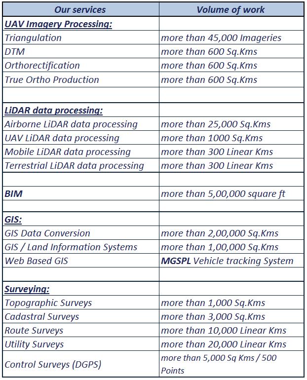
6 Page 6 of 22


7 2.1 Photogrammetric Services Marvel Geospatial Solutions (MGSPL) has an experienced Photogrammetry team equipped with the latest digital Photogrammetry systems. We offer leading edge, professional mapping services which are time and cost effective. MGSPL Offers comprehensive services in the field of Digital Photogrammetry to create 3D Data sets. Our offering includes: Aerial Triangulation Digital Elevation Model (DEM) Planimetric Mapping Terrain Modelling Topographic Mapping Orthophoto Production 3D City Modelling Aerial Triangulation We are capable of triangulating large quantity of Aerial Images, UAV Images & Satellite scenes, Capable of triangulating the images captured from latest digital cameras and sensors. We ensure the high geometric stability of the blocks with well-defined external orientation and additional parameters meeting the RMSE within tolerance. Digital Elevation Model (DEM) We use advanced autocorrelation methods to extract high accurate Digital Elevation Model (DEM). This allows us to derive a 3D model very quickly and affordably, providing maximum exploitation of imagery captured with digital aerial sensors while providing a basis for Orthophotography, Terrain Modelling, Planimetric Mapping and much more. w.marvelgeospatial.com Page 7 of 22


8 Planimetric Mapping We are capable of capturing Planimetric data from Aerial Photographs and Satellite Stereo images. We are specialized in Large Scale Mapping were the Planimetric details are captured from High Resolution Aerial Photographs with high accuracy generating precision 1-foot contour. Details like, Transportation, Buildings, Structures, Hydrography, Vegetation, Boundaries, Utilities, etc. are captured for comprehensive GIS solutions or for individual projects. Our techniques and detailed project management assure accurate results and consistent deliverables. Terrain Modelling We are involved in the development and deployment of Terrain models to support 3D analysis. Surfaces derived from LiDAR, photogrammetric Techniques and auto correlated surfaces; provide a framework for which a "skin" of realistic imagery is applied, creating a lifelike 3D scene. Topographic Mapping MGSPL compilers develop topographic data in a softcopy environment. Their workflow is designed such that edge-matching data results in a seamless project wide topographic representation. Great care is taken to ensure accurate and timely deliverables. Page 8 of 22

, geo-referencing, ortho rectification, ortho mosaic, color balancing and cut the data into")

9 Orthophoto Production We are capable of processing Aerial Images creating Ortho-rectified images. We are also capable of processing satellite images of different sensors. We do radiometric correction, atmospheric correction, Image fusion (resolution merge), histogram matching (tonal balancing), geo-referencing, ortho rectification, ortho mosaic, color balancing and cut the data into manageable small size tiles for better file We are capable of producing True Orthophoto. An Orthophoto is "correct" at the terrain level were as a True Orthophoto is geometrically correct over in the entire image. w.marvelgeospatial.com Page 9 of 22
 by implementing state of the art Work Flows and 3D engines.")

10 3D City Modelling We have extensive knowledge in preparing 3D city models with real world texture from Multiple Data sources (True Ortho Photographs, UAV, High oblique Aerial Imagery, etc.) by implementing state of the art Work Flows and 3D engines. With High level of automation in the reconstruction of building geometries and facade texturing, we have short production times and a very high level of data quality combined with a considerable reduction of costs. MGSPL has the ability to create and maintain city wide 3D models for online and offline visualization. Page 10 of 22


11 2.2 LiDAR Data Processing & Mapping MGSPL provides turn-key ALTM / Mobile / Terrestrial / UAV LiDAR data processing services: Airborne Laser Terrain Mapping (ALTM): MGSPL offers cost effective and consistent quality LiDAR services with international standards. We have extensive experience in categorizing LiDAR point cloud data to different classes like Bare earth, Buildings, Bridges, Hydrography, Low & High Vegetations, Pylons, High tension wires & Cables, etc. We also do Flight Line adjustment, advanced as-built 3D Modelling and Planimetric Mapping. Mobile / Terrestrial LiDAR: MGSPL has wide range of expertise in processing Terrestrial LiDAR data for as-built modelling and extraction of value added products. We have pioneered in the Integration of Airborne and Terrestrial LiDAR data for extracting high-resolution virtual reality content. w.marvelgeospatial.com Page 11 of 22
 Building Information Modelling (BIM) is a digital representation of the physical and functional characteristics of a facility.")
12 UAV LiDAR: We are capable of processing UAV LiDAR data from flight line adjustment to classification of point cloud data to its respective feature class and vectoring them creating 3D City Modelling. 2.3 Building Information Modelling (BIM) Building Information Modelling (BIM) is a digital representation of the physical and functional characteristics of a facility. It is a shared knowledge resource for information about a facility, forming a reliable basis for decisions during its life cycle, from earliest conception to demolition. MGSPL has wide range of expertise in BIM and is actively engaged in various International BIM production activities, seeking a synthesis between technology and effective response to the challenges of each project. MGSPL provides projects and services in the following sectors using BIM. Architecture, Engineering & Construction (AEC) services Mechanical, Electrical & Plumbing (MEP) solutions Structural, Constructions & Analysis Scan to BIM Page 12 of 22


13 Architecture, Engineering & Construction (AEC) services MGSPL develops innovative solutions directed towards the Architecture, Engineering and Construction Industries by creating & utilizing BIM, Including: 2D Drawing to 3D BIM Model 3D Rendering and Modelling 4D Construction Planning Visualization BIM Modelling 3D Coordination / Clash Detection 2D Drawing to 3D Building Modelling BIM 3D Interior Rendering and modelling 3D Coordination / Clash Detection Mechanical Electrical & Plumbing (MEP) solutions MGSPL has extensive experience in designing, documentation, cost estimation, construction planning of MEP and MEP Information Modelling, Including: Conversion of 2D design drawings to 3D models Co-ordination among various MEP trades Collision detection Fabrication drawings Shop drawings Parametric modelling and library creation of HVAC & MEP components Construction Documents Page 13 of 22


14 Shop Drawing Drafting Plumbing Fire Fighting HVAC BIM Structural Constructions & Analysis MGSPL has extensive experience in structural constructions in designing, documentation, construction planning, stress analysis and creating BIM, including: 3D Modelling & Design Construction Documentation Stress Analysis BIM 3D Designing Construction Document Page 14 of 22


15 Stress Analysis BIM Scan to BIM We are specialized in extracting intelligent BIM from Laser point cloud data Buildings: We create as-built BIM models for refurbishment, retrofit and renovation projects. Infrastructure: We create as-built BIM models for the renovation of infrastructure assets. MEP: We provide early clash detection by creating as-built BIM models for MEP services and facilities managers. Oil and Gas: We create as-built models for plant in Oil Refineries and Gas facilities Page 15 of 22

16 2.4 UAV Imagery Processing MGSPL does post-processing of high resolution UAV images, extract DTM and generate highly accurate/high resolution True Orthophoto. MGSPL has the capabilities to produce Urban cover mapping using high-spatial resolution UAV imagery which is used for Urban Planning and development. 2.5 Geographical Information System MGSPL is an Independent GIS System Integrator and focuses on end to end offerings in geospatial information services. Our offerings includes GIS Consultancy Services, GIS System Development & Implementation, off-the-rack Integration, Testing & Maintenance for various verticals, GIS Data Design & Modelling, Data Migration, Capture, Validation, Maintenance (including remote maintenance), customer application development, web-based GIS for internal project management & for external customers, Geodatabase design configuring RDBMS establishing a multiuser editing environment, Standalone and web/mobile GIS application development. Page 16 of 22


17 MGSPL offers Geospatial services for Telecom, Electric, Water & Sewer, Waste water, Gas, Land base and all other Utility Domains. 2.6 Surveying Services MGSPL provide a variety of surveying services including wetland delineation, boundary, asbuilt, tree, topographic surveys, staking of roadway and drainage projects and providing finished floor elevation certificates for real estate closings. We provide surveying services for the development of both residential & commercial properties to engineering, architectural & residential design firms. Our client list comprises numerous Federal & State Agencies, major and independent Oil & Gas Companies, pipeline companies and other industrial & private entities. The Surveying & Mapping services offered by MGSPL using Total Stations, Auto levels, GPS, Laser Scanners, etc. are: Topographic Surveys Cadastral Surveys Route Surveys Utility Surveys Urban Planning/Property Surveys DGPS Control Surveys Engineering Surveys Page 17 of 22


18 2.7 Location Based Services MGSPL is a dynamic leader in GPS/LBS products and services. MGSPL has Strategic Partners in Mobile assets, significantly reducing associated with those activities by increasing utilization, decreasing direct and indirect costs, increasing productivity and sales, fully automating business processes or providing forms and tools for mobile workers and measuring performance. Customers can use and manage their information by logging onto our website or by using automated reporting tools that send customer selected reports at customer selected intervals. We are poised to provide enterprise quality, location based integration services for large private and public corporate users and international licensees. Fleet Management Asset and Personal Safety Tracking Engine Health Monitoring Marine Vessels Tracking Mining Equipment Monitoring Personal Vehicle Tracking Tracking solutions for Logistics and Delivery Enterprises Tracking Solutions for School and Academic Institutions Tracking Solutions for Cabs, Police and Public Transport Page 18 of 22
19 3. Infrastructure MGSPL Offices are well equipped with state-of-the-art computing, networking, security and communication infrastructure. The offices are also provided with facilities such as fullfledged conference rooms with Audio conferencing facilities and complete power & system back up to operate 24/7. Office MGSPL aspires to become a leading GIS and Photogrammetry services provider. This has guided MGSPL to establish and create a work environment conducive for efficiency and innovation. Human Resource: MGSPL recognizes that its people are the primary source of its competitiveness. It is committed to equal employment opportunities for attracting the best available talent and ensuring a cosmopolitan workforce. Policy: Pursues management practices designed to enrich the quality of life of its employees, develop their potential and maximize their productivity. It will aim at ensuring transparency, fairness and equity in all its dealings with its employees. MGSPL will strive continuously to foster a climate of openness, mutual trust and teamwork. Communication: MGSPL possess resources to enable Collaborative Project Management which is increasingly being accepted as the most efficient and effective way to develop products. Hardware: MGSPL possesses an array of high-end workstations. Software: Following are the list of major GIS, Photogrammetry and LiDAR software s we expertise for providing solutions to our customers. Z/I Z-MAP Laser/Photo INPHO ESRI LEICA ORTHO PRO &ORTHO VISTA AUTODESK BENTLEY-USTATION TRIMBLE & ASHTECH ER MAPPER GLOBAL MAPPER ADOBE ERDAS IMAGINE IDRISI CADCORP ADOBE PHOTOSHOP Page 19 of 22


20 Our Technology Partners: 4. Quality Management System MGSPL has established a Quality Management System that is in compliance with the International Quality System standard ISO 9001:2008. MGSPL is committed to provide Global Geospatial Solutions to its customers by meeting the requirements with regard to Quality to enhance customer satisfaction and by continually improving the effectiveness of Quality Management System 5. Value Proposition Why Choose Our Company: In a crowded marketplace, MGSPL remains differentiated on the basis of our financial and technological strengths and strong geospatial pedigree which gives us the ability to engage very closely with our customers on end to end geospatial solutions spanning all stages of a product lifecycle. Page 20 of 22
21 We add value to our customer's processes and products in the following manner: Virtual Extended Arm of the Customer Significant reduction of Product Lifecycle, Time and Cost Innovative solutions Quality Assurance and timely delivery Proven GIS domain expertise Robust Security & business continuity Flexible Operating Models Ability to engage with customers in large & critical programs Some of our other strength includes: Customer Focus Our well trained workforce Rich Domain knowledge Strict Quality and information security standards Professionalism & Ethics Long-term stability and Relationships Financial strength State-of-the-art Infrastructure Excellent Project Management skills Effective Management Conditions: Effective Management optimization is one area that can help tremendously to optimize the overall performance of GIS and Photogrammetry solutions. To Track and optimize productive maintenance activities based on Quality Management System check lists throughout all operational activities on company standards. Delivery of Effective Products and Services: MGSPL has been delivering products on time under the client time constraints framework in effective manner and we are fulfilling our customer satisfaction through quality services. Page 21 of 22
22 6. Contact Us INDIA Mr. Raghu (Raghavendra Boyapally) Marvel Geospatial Solutions Pvt. Ltd. 9-22/1/B, Shapoor Hall Shapoorwadi, Aadarsh Nagar Hyderabad Telangana, India. Land Mark: Opp. New MLA Quarters UNITED STATES Mr. Bob Shafer Marvel Geospatial Solutions Pvt. Ltd. Denver, Colorado Phone: , Phone/Fax: info@marvelgeospatial.com Page 22 of 22
A Broad View of Geospatial Technology & Systems
 A Broad View of Geospatial Technology & Systems Pete Large Vice President, Trimble On the shoulders of giants 1 Since their time, our ability to generate geospatial information has grown exponentially
SOLUTIONS ADVANCED GIS. TekMindz are developing innovative solutions that integrate geographic information with niche business applications.
 ADVANCED GIS SOLUTIONS TekMindz are developing innovative solutions that integrate geographic information with niche business applications. TEK INDZ TM GIS Services Overview At the leading edge of geospatial
Exploring the boundaries of your built and natural world. Geomatics
 Exploring the boundaries of your built and natural world Geomatics Before the Luxor brought magic to the Las Vegas strip and before the South LRT extension in Edmonton gave residents a new route to travel,
VISUALIZING THE SMART CITY 3D SPATIAL INFRASTRUCTURE GEOSMART ASIA- 30 SEP, 2015
 www.aamgroup.com VISUALIZING THE SMART CITY 3D SPATIAL INFRASTRUCTURE GEOSMART ASIA- 30 SEP, 2015 Agenda AAM What is a Smart City? Data Acquisition 3D Modelling Benefits Questions AAM AAM is a Geospatial
G EOSPAT I A L ERDAS IMAGINE. The world s most widely-used software package for creating information from geospatial data
 G EOSPAT I A L ERDAS IMAGINE The world s most widely-used software package for creating information from geospatial data ERDAS IMAGINE Geographic imaging professionals need to process vast amounts of
Building a National Data Repository
 Building a National Data Repository Mladen Stojic, Vice President - Geospatial 1/30/2013 2012 Intergraph Corporation 1 Information has meaning and gives power only when shared and distributed. Information,
GEOMATICS. Shaping our world. A company of
 GEOMATICS Shaping our world A company of OUR EXPERTISE Geomatics Geomatics plays a mayor role in hydropower, land and water resources, urban development, transport & mobility, renewable energy, and infrastructure
STEREO ANALYST FOR ERDAS IMAGINE Stereo Feature Collection for the GIS Professional
 STEREO ANALYST FOR ERDAS IMAGINE Stereo Feature Collection for the GIS Professional STEREO ANALYST FOR ERDAS IMAGINE Has Your GIS Gone Flat? Hexagon Geospatial takes three-dimensional geographic imaging
1994: JV formed for civil engineering consultancy COWI/KX A/s, Denmark(51%) IFU, Denmark (24% ) IL&FS Infrastructure Dev Corp, India(25%)
 IFU, Denmark (24% ) IL&FS Infrastructure Dev Corp, India(25%)") Company Profile 1994: JV formed for civil engineering consultancy COWI/KX A/s, Denmark(51%) IFU, Denmark (24% ) IL&FS Infrastructure Dev Corp, India(25%) 1998: Start of mapping as a new segment of Business.
Company Profile 1994: JV formed for civil engineering consultancy COWI/KX A/s, Denmark(51%) IFU, Denmark (24% ) IL&FS Infrastructure Dev Corp, India(25%) 1998: Start of mapping as a new segment of Business.
Technical Drafting, Geographic Information Systems and Computer- Based Cartography
 Technical Drafting, Geographic Information Systems and Computer- Based Cartography Project-Specific and Regional Resource Mapping Services Geographic Information Systems - Spatial Analysis Terrestrial
Imagery and the Location-enabled Platform in State and Local Government
 Imagery and the Location-enabled Platform in State and Local Government Fred Limp, Director, CAST Jim Farley, Vice President, Leica Geosystems Oracle Spatial Users Group Denver, March 10, 2005 TM TM Discussion
Cartographic and Geospatial Futures
 Cartographic and Geospatial Futures 1. Web Cartography, WebGIS, & Virtual Globes--New Roles for Maps, GIS, and GIS professionals 2. Map Mashups, the Neo Neo-geography Movement, & Crowd-sourcing Geospatial
June 19 Huntsville, Alabama 1
 June 19 Huntsville, Alabama 1 Real-Time Geospatial Data: The Fusion of PI and ArcGIS Enabling Smarter Facilities Management OSIsoft and Esri Mapping and Location Analytics Platform Supporting Your Use
Esri and GIS Education
 Esri and GIS Education Organizations Esri Users 1,200 National Government Agencies 11,500 States & Regional Agencies 30,800 Cities & Local Governments 32,000 Businesses 8,500 Utilities 12,600 NGOs 11,000
BANGLADESH SURVEY OF BANGLADESH PREMISES
 BANGLADESH SURVEY OF BANGLADESH PREMISES Survey of Bangladesh (SOB) is the National Mapping organization of Bangladesh SOB is carrying out all Geodetic activities of Bangladesh SOB is responsible for taking
An Industry Perspective. Bryn Fosburgh Vice President Trimble
 An Industry Perspective Bryn Fosburgh Vice President Trimble Who are we? Professionals & Consultants Geospatial Professionals working at or with: AEC Consultants Transportation Departments Construction
GEOMATICS SURVEYING AND MAPPING EXPERTS FOR OVER 35 YEARS
 GEOMATICS SURVEYING AND MAPPING EXPERTS FOR OVER 35 YEARS 2 GEOMATICS AND SURVEYING SOLUTIONS SPANNING THE ENTIRE PROJECT LIFECYCLE 1,000+ 250+ 24 Surveying professionals Active field crews Geomatics offices
MAPPS 2012 Geospatial Products and Services Excellence Awards Awards Entry Form
 MAPPS 2012 Geospatial Products and Services Excellence Awards 2012 Awards Entry Form Please include a copy of this document with the project/product submission Entry Information Submission Number: 1741558
UAV APPLICATIONS IN ENGINEERING. Presented By Wohnrade Civil Engineers, Inc.
 UAV APPLICATIONS IN ENGINEERING Presented By Wohnrade Civil Engineers, Inc. UAV BUSINESS STARTUP March 31, 2015 - Obtained DJI Inspire 1 Unmanned Aerial Vehicle (UAV) FAA requires Certificate of Authorization
Airborne Corridor-Mapping. Planning and documentation of company infrastructure: precise, rapid, and cost effective
 Airborne Corridor-Mapping Planning and documentation of company infrastructure: precise, rapid, and cost effective Technology Airborne Laser-Scanning, digital orthophotos and thermal imaging: one flight
TRAITS to put you on the map
 TRAITS to put you on the map Know what s where See the big picture Connect the dots Get it right Use where to say WOW Look around Spread the word Make it yours Finding your way Location is associated with
Data Aggregation with InfraWorks and ArcGIS for Visualization, Analysis, and Planning
 Data Aggregation with InfraWorks and ArcGIS for Visualization, Analysis, and Planning Stephen Brockwell President, Brockwell IT Consulting, Inc. Join the conversation #AU2017 KEYWORD Class Summary Silos
Ramani Geosystems. Putting Africa On The Map. Authorized Resellers
 Ramani Geosystems Putting Africa On The Map Authorized Resellers Ramani Profile Started in 1999 Aerial, Land Surveying & Mapping Solutions + 10 Countries in the region + 80 Staff working in projects Asset
An online data and consulting resource of THE UNIVERSITY OF TOLEDO THE JACK FORD URBAN AFFAIRS CENTER
 An online data and consulting resource of THE JACK FORD URBAN AFFAIRS CENTER THE CENTER FOR GEOGRAPHIC INFORMATION SCIENCE AND APPLIED GEOGRAPHICS DEPARTMENT OF GEOGRAPHY AND PLANNING THE UNIVERSITY OF
Bentley Map Advancing GIS for the World s Infrastructure
 Bentley Map Advancing GIS for the World s Infrastructure Presentation Overview Why would you need Bentley Map? What is Bentley Map? Where is Bentley Map Used? Why would you need Bentley Map? Because your
 Boone County GIS has the right to inquire about and investigate the use of any requested products and deny access to anyone based on concerns relating to privacy, security, public health, public safety,
ENV208/ENV508 Applied GIS. Week 1: What is GIS?
 ENV208/ENV508 Applied GIS Week 1: What is GIS? 1 WHAT IS GIS? A GIS integrates hardware, software, and data for capturing, managing, analyzing, and displaying all forms of geographically referenced information.
Data Origin. Ron van Lammeren CGI-GIRS 0910
 Data Origin Ron van Lammeren CGI-GIRS 0910 How to obtain geodata? Geo data initiative Executive Order 12906, "Coordinating Geographic Data Acquisition and Access: The National Spatial Data Infrastructure,"
indigeo Consultants Pvt Ltd Geophysical Surveys Geological Surveys GIS & Data Solutions Image Processing indigeo Company Profile, Page 1
 indigeo Consultants Pvt Ltd Geophysical Surveys Geological Surveys GIS & Data Solutions Image Processing MM Corner, 3 rd Floor #58, Banaswadi Main Road Bangalore 560033 INDIA Ph: +91 80 41638310 Mob: +91
Emergency Planning. for the. Democratic National. Convention. imaging notes // Spring 2009 //
 Emergency Planning for the Democratic National Convention The DRAPP Demonstrates Partnership among Local, Regional, State, Utility and Federal Governments 14 imaging notes // Spring 2009 // www.imagingnotes.com
FIRE DEPARMENT SANTA CLARA COUNTY
 DEFINITION FIRE DEPARMENT SANTA CLARA COUNTY GEOGRAPHIC INFORMATION SYSTEM (GIS) ANALYST Under the direction of the Information Technology Officer, the GIS Analyst provides geo-spatial strategic planning,
THE USE OF GEOMATICS IN CULTURAL HERITAGE AND ARCHAEOLOGY FOR VARIOUS PURPOSES
 THE USE OF GEOMATICS IN CULTURAL HERITAGE AND ARCHAEOLOGY FOR VARIOUS PURPOSES FEBRUARY 2013 AL BEIDA GEOPLAN CONTENT Company Profile Concept Objectives and Strategies Data Production Methods Data Samples
GIS Geographical Information Systems. GIS Management
 GIS Geographical Information Systems GIS Management Difficulties on establishing a GIS Funding GIS Determining Project Standards Data Gathering Map Development Recruiting GIS Professionals Educating Staff
Industry Trends and Direction: a quick look! John Whitehead Trimble Navigation Ltd.
 Industry Trends and Direction: a quick look! John Whitehead Trimble Navigation Ltd. Converging forces have placed geospatial information at the center of an evolving ecosystem Technology Societal Forces
ArcGIS. for Server. Understanding our World
 ArcGIS for Server Understanding our World ArcGIS for Server Create, Distribute, and Manage GIS Services You can use ArcGIS for Server to create services from your mapping and geographic information system
CHARTING SPATIAL BUSINESS TRANSFORMATION
 CHARTING SPATIAL BUSINESS TRANSFORMATION An in-depth look at the business patterns of GIS and location intelligence adoption in the private sector EXECUTIVE SUMMARY The global use of geographic information
Geographic Information System Services. Strategic Plan FY
 Geographic Information System Services Strategic Plan FY 2011 2012 Drafted by: Gary Palmer, Assistant Town Manager Major Sections: History Mission, Vision, Values Strategic Issues Performance Measurement
QUALITY CONTROL ROLE IN PROCESS OF ESTABLISHMENT OF NSDI
 QUALITY CONTROL ROLE IN PROCESS OF ESTABLISHMENT OF NSDI S. Lemajić a,lj. Rašić b a Croatian Geodetic Institute, Savska 41/XVI, Zagreb, Croatia slavko.lemajic@cgi.hr b State Geodetic Administration, Lastovska
Features and Benefits
 Autodesk LandXplorer Features and Benefits Use the Autodesk LandXplorer software family to help improve decision making, lower costs, view and share changes, and avoid the expense of creating physical
What s the problem? A Modern Odyssey in Search of Relevance. The search for relevance. Some current drivers for new services. Some Major Applications
 A Modern Odyssey in Search of Relevance FIG Working Week, Athens, 24 May 2004 Paul Kelly ANZLIC Executive Director The search for relevance 1. New expectations for spatial services 2. Are we ready to meet
Advancing Geoscientific Capability. Geological Survey of Finland
 Advancing Geoscientific Capability Geological Survey of Finland GTK in brief The Geological Survey of Finland (GTK) is one of the largest European centres of excellence in assessment, research and the
Production Line Tool Sets
 Production Line Tool Sets Tools for high-quality database production and cartographic output Production Line Tool Sets Production Line Tool Sets (PLTS) by ESRI are a collection of software applications
CARTOGRAPHIC INFORMATION MANAGEMENT IN COLOMBIA REACH A LEVEL OF PERFECTION
 CARTOGRAPHIC INFORMATION MANAGEMENT IN COLOMBIA REACH A LEVEL OF PERFECTION Jaime Alberto Duarte Castro 1 Carrera 30 No. 48 51 Bogotá - Colombia, jduarte@igac.gov.co Claudia Inés Sepúlveda Fajardo 2 Carrera
Mapping a Nation in 3D Singapore s Journey. Bryan Chew Registrar of Titles Assistant Chief Executive Singapore Land Authority
 Mapping a Nation in 3D Singapore s Journey Bryan Chew Registrar of Titles Assistant Chief Executive Singapore Land Authority Singapore Size - 719 sq km Population - 5.5 million Density 7,600/sq km Singapore
First on the Ground. Geomatics
 First on the Ground Geomatics Surveying and mapping solutions spanning the entire project lifecycle Part art, part science, part technology, the Geomatics profession is constantly evolving. From the very
GIS = Geographic Information Systems;
 What is GIS GIS = Geographic Information Systems; What Information are we talking about? Information about anything that has a place (e.g. locations of features, address of people) on Earth s surface,
P R O U D LY C A N A D I A N
 P R O U D LY C A N A D I A N 1.855.423.3185 info@rmegeomatics.com AERIAL SURVEYING IMAGING TERRAIN ANALYSIS WHO WE ARE HSE & REGULATORY CLIENT INDUSTRIES RME Geomatics (formerly NGF Geomatics) was founded
The AMGI project: A Brief Overview
 The AMGI project: A Brief Overview World Bank Group (Energy & Extractives Global Practice) GEEDR Francisco Igualada (figualada@worldbank.org) Presented by Ash Johnson, Geosoft Inc. The AMGI Project: Vision
GIS Products & Solutions
 GIS Products & Solutions We aim at providing our client with the best in GIS and Remote Sensing. We have an experience of ten years of working and associations of some of the best organizations in the
UTAH S STATEWIDE GEOGRAPHIC INFORMATION DATABASE
 UTAH S STATEWIDE GEOGRAPHIC INFORMATION DATABASE Data Information and Knowledge Management NASCIO Awards 2009 STATE GEOGRAPHIC INFORMATION DATABASE B. EXECUTIVE SUMMARY Utah has developed one of the most
Innovation in mapping and photogrammetry at the Survey of Israel
 16, October, 2017 Innovation in mapping and photogrammetry at the Survey of Israel Yaron Felus and Ronen Regev Contents Why HD mapping? Government requirements Mapping regulations o Quality requirements
Qatar s Nation-Wide GIS Cooperation on Local and Regional Levels
 Qatar s Nation-Wide GIS Cooperation on Local and Regional Levels Dr. Mohammad Abd El-Wahab Hamouda GIS Consultant & Chairman of GIS Coordinators Group The Center for GIS State of Qatar Second High Level
THE NEW CHALLENGES FOR THE HIGHER EDUCATION OF GEODESY IN UACEG SOFIA
 THE NEW CHALLENGES FOR THE HIGHER EDUCATION OF GEODESY IN UACEG SOFIA Ivan Kunchev University of Architecture, Civil Engineering and Geodesy, 1 Hristo Smirnenski Blvd., Sofia 1046, Bulgaria Abstract Report
T: E:
 PAS 128 UTILITY DETECTION AND MAPPING TOPOGRAPHICAL SURVEYS UTILITY RECORD SEARCHES AND DESK TOP STUDY SURFACE WATER DRAINAGE SURVEYS GROUND CLEARANCE SURVEYS MEASURED BUILDING SURVEYS LASER SCANNING UAV
ESRI Survey Summit August Clint Brown Director of ESRI Software Products
 ESRI Survey Summit August 2006 Clint Brown Director of ESRI Software Products Cadastral Fabric How does Cadastral fit with Survey? Surveyors process raw field observations Survey measurements define high-order
GEOGRAPHIC INFORMATION SYSTEMS Session 8
 GEOGRAPHIC INFORMATION SYSTEMS Session 8 Introduction Geography underpins all activities associated with a census Census geography is essential to plan and manage fieldwork as well as to report results
Large Scale Mapping Policy for the Province of Nova Scotia
 Large Scale Mapping Policy for the Province of Nova Scotia December, 2005 Version 1.0 TABLE OF CONTENTS PAGE BACKGROUND...3 POLICY...5 Policy 1.0 Large Scale Mapping Program...5 Policy 2.0 Service Offering...5
Data Origin. How to obtain geodata? Ron van Lammeren CGI-GIRS 0910
 Data Origin How to obtain geodata? Ron van Lammeren CGI-GIRS 0910 Spatial Data interest Improvement of policy making. ± 90% of all information used by government has spatial characteristics SPATIAL INFORMATION
SUPPORTS SUSTAINABLE GROWTH
 DDSS BBUUN NDDLLEE G E O S P AT I A L G O V E R N A N C E P A C K A G E SUPPORTS SUSTAINABLE GROWTH www.digitalglobe.com BRISBANE, AUSTRALIA WORLDVIEW-3 30 CM International Civil Government Programs US
OC Enterprise GIS. Kevin Hills, PLS Cameron Smith, GISP. OC Survey
 OC Enterprise GIS Kevin Hills, PLS Cameron Smith, GISP OC Survey Discussion Points Background & Organizational Structure of OCPW Past practices prior to Enterprise Wide GIS License (ELA) Participating
Excel Geomatics: Offering Excellence with Unique Consultancy & Services
 Excel Geomatics: Offering Excellence with Unique Consultancy & Services Providing consultancy and value Added Services using Remote Sensing, Photogrammetry and LiDAR in areas such as Agriculture, Forestry,
Country Report on SDI Activities in Singapore *
 UNITED NATIONS E/CONF.100/CRP.9 ECONOMIC AND SOCIAL COUNCIL Eighteenth United Nations Regional Cartographic Conference for Asia and the Pacific Bangkok, 26-29 October 2009 Item 7(a) of the provisional
When Map Quality Matters
 When Map Quality Matters 50% 25% Powerful geospatial mapping tools for Adobe Creative Cloud and offline map solutions for mobile devices 20% When Map Quality Matters 10% We re focused on creating powerful
Web-Based 3D Geospatial Facility Model Data Interfaces
 Web-Based 3D Geospatial Facility Model Interfaces Federal Facilities Council Symposia October 31, 2006 BIM: Grass Root Experiences Alex Viana Naval Facilities Engineering Command Washington Navy Yard,
Putting the U.S. Geospatial Services Industry On the Map
 Putting the U.S. Geospatial Services Industry On the Map December 2012 Definition of geospatial services and the focus of this economic study Geospatial services Geospatial services industry Allow consumers,
STATEMENT OF QUALIFICATIONS
 STATEMENT OF QUALIFICATIONS GSP Consulting Gary Poland - President 2050 Longley Lane #1603 Reno, NV 89502 Phone: (775) 857-1362 Cell: (775) 240-5880 Synergy Mapping Laddie Kent Vice President 6551 S. Revere
Investigating the practical relationship between GIS and BIM; then relating that to a 3D cadastre. J. Gabriel van Wyk, Johan Nel
 Investigating the practical relationship between GIS and BIM; then relating that to a 3D cadastre. J. Gabriel van Wyk, Johan Nel Overview So exactly what is BIM? Available BIM offerings in the market Traditional
GIS Visualization: A Library s Pursuit Towards Creative and Innovative Research
 GIS Visualization: A Library s Pursuit Towards Creative and Innovative Research Justin B. Sorensen J. Willard Marriott Library University of Utah justin.sorensen@utah.edu Abstract As emerging technologies
Creating an On Target Geospatial Foundation for the Navajo Housing Authority
 Creating an On Target Geospatial Foundation for the Navajo Housing Authority 2012 Geospatial Excellence Awards MAPPS 2012 Geospatial Products and Services Excellence Awards 2012 Awards Entry Form Please
Statewide Topographic Mapping Program
 Statewide Topographic Mapping Program February 28, 2018 www.dotd.la.gov Outline Purpose of the Statewide Topographic Mapping Program History Breakdown of R.S. 48:36 - Topographic Mapping Statewide Topographic
Alluvium Consulting Australia Senior integrated water management specialist Position Description March 2018
 Alluvium Consulting Australia Senior integrated water management specialist Position Description March 2018 Overview of Alluvium We are an employee-owned consulting firm founded in 2006 to provide advice
The Pace of Change Is Accelerating Creating Many Challenges
 VISION The Pace of Change Is Accelerating Creating Many Challenges Evidence Threatening Our Natural World and Our Future as Humans Social Conflict Mass Migration Ocean Acidification Food Population Urbanization
Better Topographic Map Production Using ArcGIS. A Comprehensive Solution for Mapping Organizations
 Better Topographic Map Production Using ArcGIS A Comprehensive Solution for Mapping Organizations The World Is Always Changing As a member of a national mapping organization, you know this is true. You
geographic patterns and processes are captured and represented using computer technologies
 Proposed Certificate in Geographic Information Science Department of Geographical and Sustainability Sciences Submitted: November 9, 2016 Geographic information systems (GIS) capture the complex spatial
Oregon Department of Transportation. Geographic Information Systems Strategic Plan
 Oregon Department of Transportation Geographic Information Systems Strategic Plan Adopted May, 2000 By the GIS Steering Committee Last printed 10/2/2012 4:20:00 PM Page Geographic Information Systems Strategic
The University of Arizona Enterprise GIS. CFTA 2016 Facilities Geospatial Technologies Showcase
 The University of Arizona Enterprise GIS CFTA 2016 Facilities Geospatial Technologies Showcase Main Campus: Tucson, Arizona Founded: 1885 Number of Buildings: 227 GSF: 9.4 million Acres: 393 Total Students:
2011 Oracle Spatial Excellence Awards Presentation
 2011 Oracle Spatial Excellence Awards Presentation May 19, 2011 Ronald Reagan Building and International Trade Center Washington, DC USA Thanks to our sponsors Media Sponsor Media Participants Media Sponsor
Basic Act on the Advancement of Utilizing Geospatial Information
 Basic Act on the Advancement of Utilizing Geospatial Information (Act No. 63 of May 30, 2007) Table of Contents Chapter I General Provisions (Articles 1 to 8) Chapter II Basic Plan for the Advancement
Web GIS: Architectural Patterns and Practices. Shannon Kalisky Philip Heede
 Web GIS: Architectural Patterns and Practices Shannon Kalisky Philip Heede Web GIS Transformation of the ArcGIS Platform Desktop Apps Server GIS Web Maps Web Scenes Layers Web GIS Transformation of the
State of Israel Ministry of Housing and Construction Survey of Israel. The Hydrological project case
 State of Israel Ministry of Housing and Construction Survey of Israel The Hydrological project case Survey of Israel Content Introduction To the Survey of Israel The operation assumptions The main responsibilities
ORTHOPHOTO PROGRAM FREQUENTLY ASKED QUESTIONS
 ORTHOPHOTO PROGRAM FREQUENTLY ASKED QUESTIONS June 4, 2014 Document Purpose The Florida Department of Revenue (DOR) regularly receives questions regarding its orthophoto program. This document answers
Spatial Data Availability Energizes Florida s Citizens
 NASCIO 2016 Recognition Awards Nomination Spatial Data Availability Energizes Florida s Citizens State of Florida Agency for State Technology & Department of Environmental Protection Category: ICT Innovations
REQUEST FOR PROPOSALS FOR DIGITAL ORTHOPHOTOGRAPHY PROJECT
 REQUEST FOR PROPOSALS FOR DIGITAL ORTHOPHOTOGRAPHY PROJECT The purpose of this Request for Proposals (RFP) is to solicit responses from qualified professionals for the production and supply of ortho rectified
EuroSDR (European Spatial Data Research)
") EuroSDR (European Spatial Data Research) ROLLING RESEARCH PLAN 2015-2018 EuroSDR Secretariat Public Governance Institute KU Leuven Parkstraat 45 bus 3609 3000 Leuven Belgium Tel.: +32 16 32 31 80 Fax:
EuroSDR (European Spatial Data Research) ROLLING RESEARCH PLAN 2015-2018 EuroSDR Secretariat Public Governance Institute KU Leuven Parkstraat 45 bus 3609 3000 Leuven Belgium Tel.: +32 16 32 31 80 Fax:
Excel Geomatics. Rajesh Paul Excel Geomatics Pvt. Ltd., Noida February, 2015 India Geospatial Forum, Hyderabad
 Excel Geomatics Geo-marketing for Product Sales and Customer Services Rajesh Paul Excel Geomatics Pvt. Ltd., Noida 10-12 February, 2015 India Geospatial Forum, Hyderabad Presentation Outline About Excel
Geospatial Excellence
 Geospatial Excellence Reality Captured. Certainty Delivered. OUR SERVICES Airborne Survey AAM s diverse range of aerial survey technologies ensures the best tool is deployed to suit the accuracy, timeliness
STATE GEOGRAPHIC INFORMATION DATABASE
 STATE GEOGRAPHIC INFORMATION DATABASE Data Information and Knowledge Management STATE GEOGRAPHIC INFORMATION DATABASE EXECUTIVE SUMMARY Utah has developed one of the most comprehensive statewide GIS resources
Florida Department of Transportation s
 Controls Conference - Hyatt Regency Savannah, Georgia - April 14-18, 2013 Florida Department of Transportation s 1) Virtual R/W Application Development 2) 3D Utility Mapping for 3D Design Update John Krause,
ArcGIS for Desktop. ArcGIS for Desktop is the primary authoring tool for the ArcGIS platform.
 ArcGIS for Desktop ArcGIS for Desktop ArcGIS for Desktop is the primary authoring tool for the ArcGIS platform. Beyond showing your data as points on a map, ArcGIS for Desktop gives you the power to manage
Scott Sitzman and Paloma Urbano. A Global Approach to Building a GIS Strategy. Esri Petroleum Conference April 2014
 Scott Sitzman and Paloma Urbano A Global Approach to Building a GIS Strategy Esri Petroleum Conference April 2014 1 GIS Strategy Study Methodology Maturity Model by Carnegie Mellon Current State Review
Geospatial capabilities, spatial data and services provided by Military Geographic Service
 Geospatial capabilities, spatial data and services provided by Military Geographic Service LtC Mariyan Markov PhD CONTENTS 1. INTRODUCTION - Workflow - Data sources remote sensing, direct field observation.
Cutting Edge Engineering for Modern Geospatial Systems Rear Admiral Dr. S Kulshrestha, retd
 Cutting Edge Engineering for Modern Geospatial Systems Rear Admiral Dr. S Kulshrestha, retd 11 Jun 2015 GeoIntelligence Asia 2015 The technology would become so pervasive that it becomes a part of you
3D City GIS. Agenda. Why 3D City GIS? What does 3D City GIS mean?
 3D City GIS 1 of 60 WWW.BENTLEY.COM Ben Fredericque, Product Manager, Geospatial Agenda Why 3D City GIS? What does 3D City GIS mean? 2 of 60 WWW.BENTLEY.COM Sydney, Australia, 11 16 April 2010 1 Why 3D
Aerial Survey of Coffee Estates
 Aerial Survey of Coffee Estates Why get an Aerial Survey of your Coffee Estate done? Aerial surveying produces high resolution and highly accurate image data about your coffee estate. This data can be
NCTCOG Regional GIS Meeting 6-Years and Going Strong. May 15, 2018 hosted by: Tarrant County
 NCTCOG Regional GIS Meeting 6-Years and Going Strong May 15, 2018 hosted by: Tarrant County Woolpert at a Glance 1911 Founded in Dayton, Ohio 25+ Offices across the nation 800+ Global employees 25+ OFFICES
Sustainable and Harmonised Development for Smart Cities The Role of Geospatial Reference Data. Peter Creuzer
 Sustainable and Harmonised Development for Smart Cities The Role of Geospatial Reference Data Peter Creuzer 1. Introduction - Smart Cities and Geodata 2. Geodata in Germany 3. Examples 4. Data and Service
A Global Approach to Building a GIS Strategy Esri UC July 15th, 2014
 Scott Sitzman and Paloma Urbano A Global Approach to Building a GIS Strategy Esri UC July 15th, 2014 1 METHODOLOGY 2 GIS Strategy Study Methodology Maturity Model by Carnegie Mellon Current State Review
Utah UIC Geospatial Integration EIEN Project
 Utah UIC Geospatial Integration EIEN Project ESRI UC, June 2007 Bert Granberg Utah Automated Geographic Reference Center Utah Automated Geographic Reference Center (AGRC) AGRC Responsibilities Facilitate
Exploit your geodata to enable smart cities and countries
 Exploit your geodata to enable smart cities and countries Carsten Rönsdorf, Head of Advisory Services Middle East Practice Manager Future Cities, standards and 3D 24 November 2014 Importance of Standards
Developing a Campus-wide Base Map for Planning, Design and Construction. June 21, 2007
 Developing a Campus-wide Base Map for Planning, Design and Construction June 21, 2007 Presenters Berent Pippert UCR Project Manager Capital and Physical Planning Academic Planning and Budget 951-827-2431