The AMGI project: A Brief Overview
|
|
|
- Rodger Nicholson
- 5 years ago
- Views:
Transcription
 GEEDR Francisco Igualada (figualada@worldbank.")
1 The AMGI project: A Brief Overview World Bank Group (Energy & Extractives Global Practice) GEEDR Francisco Igualada (figualada@worldbank.org) Presented by Ash Johnson, Geosoft Inc.
.")
 Maximize economic development impacts through enhanced mining sector")
2 The AMGI Project: Vision and Mission Under the political umbrella of the AFRICAN UNION, the AMGI Project (African Minerals Geoscience Initiative) has been endorsed by African Governments as a pillar of the AFRICAN MINING VISION (AMV). Mission of the AMGI is to: Provide public geo-data to a global audience and to accelerate and cost reduce the exploration process De-risk investments to improve value assessment Improve competitiveness and transparency in the mining sector Improve benefits to States (by avoiding asymmetrical disadvantage) Maximize economic development impacts through enhanced mining sector conditions Use geodata as a multi-sector asset to derive other related mapping products used for development Vision statement: AMGI aims to be a single, secure, complete on-line store of digital geodata with access controlled by entitlement.

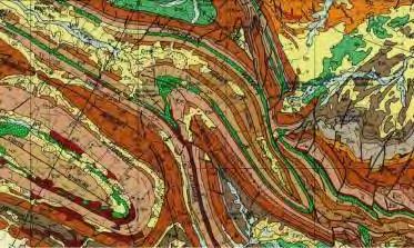
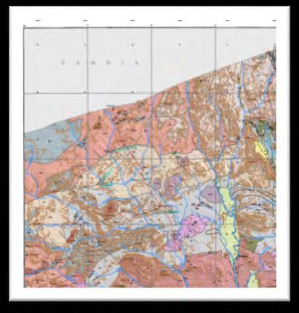
3 The AMGI Deliverables Foundation Layer (Topographic Mapping) Geo-Data (Geological Mapping) (Billion Dollar Map of Africa) Storage of vector Geo-Data Repository (2)
4 How will this be done? Recovering, replicating, re-conditioning and carrying out a re-interpretation workflow of existing relevant geoscience information or geodata Ensuring data integrity and geodatabase homogeneity at a working level (common foundation imagery layer) Facilitating a safe repository for new and existing geodata for enabling a future integration with geophysical, geochemical and regolith information. Enabling geodata exchange services (Fast Delivery), interoperability and trading, where appropriate
5 How will this be done? Delivering geodata cost-effectively to owners and endusers ensuring ownership, accessibility and security. Making public geodata improvements through the integration & (addition) of geospatial-type of standard exploration reports Promoting data dissemination for investment attraction, exploration valuation and other value-added services Developing new datasets (Value-added) according to agreed priorities based on exploration, valuation or any other need (such as detailed prospectivity targeting and geophysical re-interpretation)
 Track-2 Value Added (VA)- Value-Added services and products through re-interpretation at 1:50k")
6 Project components Track-1 Fast Delivery (FD)- Fast Delivery of geodata services by compiling, geo-referencing and compiling existing geodata and make it available through the web. Likely 1:250k to 1:100k Pilot Projects (three test areas in southern Africa of one degree by one degree) Track-2 Value Added (VA)- Value-Added services and products through re-interpretation at 1:50k to 1:100k scales suitable for basic exploration purposes Capacity building: The AMGI Billion Dollar Map, is an initiative that aims to build capacity within African national institutions to collect, collate and reinterpret all the geodata that has already been produced, assess the gaps and define priorities for the generation of new data. Partnerships: Key for the success of AMGI and includes NGS, Mining houses, service providers, training institutions and technology drivers among many others. 6


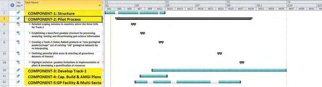
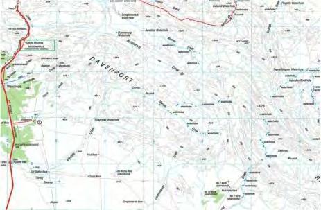
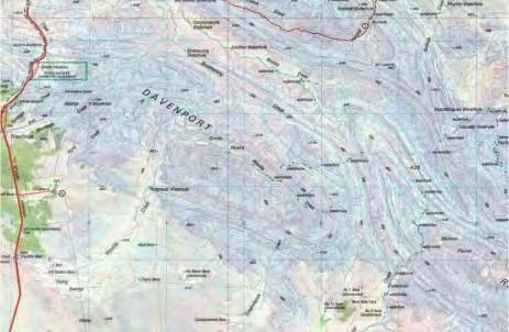
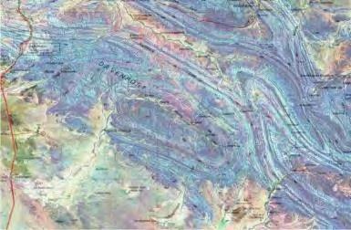
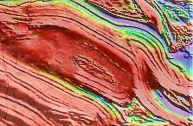
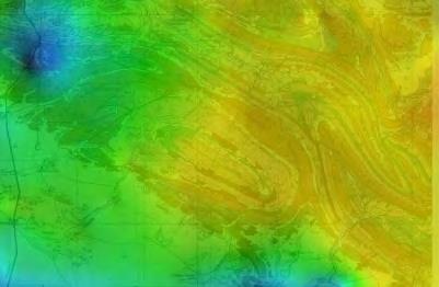
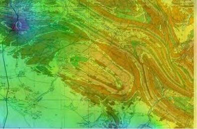
7 Going from 1: to 1: scale 7
 TRACK-2 (VA) Value-Added National (African)")


 Geo-data schema")
 QA/QC Storage Geodata Repository (1) ATLAS")

 Processes for Geo-Data Production,")

 Fast-Delivery Other Data Providers Data")
 Geological Surveys Cloud Storage")
8 Overview of Track-1 (FD) and Track-2 Value-Added (VA) TRACK-2 (VA) Value-Added National (African) Geological Surveys TRACK Cloud Storage Mining Cadastre Offices QA/QC GIS Vector Geo-data fully homogenised and interoperable Re-interpretation Production Work Flows 25% coverage Remaining 75% on demand basis Foundation data Sat. imagery Scanning & Organizing (IM) Geo-data schema Georeferencing Storage of vector Geo-data Repository (2) QA/QC Storage Geodata Repository (1) ATLAS (Maps) Interface (including Value Added) WEB Users / Beneficiaries Clients 100 % coverage REPRESENTS the PROCESSES TO GENERATE GeoData For the Billion Dollar Map, AMGI (AMV) Processes for Geo-Data Production, Storage and Dissemination through two parallel paths: Track-1 Fast delivery services and Track-2 Value-Added services & products. TRACK-1 (FD) Fast-Delivery Other Data Providers Data Sources / Providers European Geological Surveys National (African) Geological Surveys Cloud Storage Mineral / Mining Exploration firms Consulting Companies Mining Financial Investors 8
 Cont 1 2 Block")


 3 Subsets")
 Orthorectification")
")

 MGCP Topo Map")


 6 New Ground")

9 Track-2 Value-Added (VA) Cont 1 2 Block Triangulation -1 Imagery Ordering Data Preparation General Workflow: Process for Geological Mapping (VA-Track-2) 3 Subsets Images (Image-chips GPS) Orthorectification & Image Processing (1rst Stage) (Integration & Enhanced Geophysical Interpretation is not included) MGCP Topo Map data Schema GEOLOGICAL Map data Schema Stereo (3D) satellite image analysis & Anaglyph 8 Geological 3D Re-Interpretation GIS Feature Extraction 9 Radar data processing Interpretation Orthorectification (2nd Stage) 4 Spectral Analysis (several datsets) Mapping Products Base TopoMap (MGCP) & Image-Map Mosaics Block Triangulation-2 For Stereo viewing 7 Interpretation Help e.g. Russian maps 1:200K Geological Reports Collateral Info) 6 New Ground Control Points From Seismic Surveys Subsets Images (Image-chips GPS) 5 Final Orthorectified Image Maps 1:100k and 1: 50K Interpretation supported by other thematic maps Geological Reports and Collateral Info Verification & Field checks 10 9
10 Summary 1. The mineral sector is driven by exploration and this activity needs Geodata as the critical asset. 2. Joint efforts in detailed scale mapping (e.g. AMGI) and GeoData are fundamental for attracting mineral investors bringing economic development to countries. 3. Need for further work for GIS-based prospectivity analysis and initial-stage asset valuation. In using GeoData (a.-unbiased sample & b.- uniform area coverage ) 4. Interoperability and GeoData quality/reliability is a critical component. 10
11 Summary 5. GeoData has an intrinsic value linked to the knowledge derived and NOT the actual cost of data. 6. Standardization is key for communicating and, bringing TRUST to the mining picture which is often seen as an unreliable and rapidly changing sector with little transparency. 7. Geodata derived from geoscience information must be considered as multi-sector in terms of uses and by-products. 8. GeoData is part of a continuous workflow involving public and private sector sources through multisector uses (key justification for investing). 11
The Global Statistical Geospatial Framework and the Global Fundamental Geospatial Themes
 The Global Statistical Geospatial Framework and the Global Fundamental Geospatial Themes Sub-regional workshop on integration of administrative data, big data and geospatial information for the compilation
Advancing Geoscientific Capability. Geological Survey of Finland
 Advancing Geoscientific Capability Geological Survey of Finland GTK in brief The Geological Survey of Finland (GTK) is one of the largest European centres of excellence in assessment, research and the
NSDI as a tool for Secure land tenure
 NSDI as a tool for Secure land tenure General Overview To look at the progress in SDI development and its application in policy formulation and impact on land tenure. INTEGRATION OF INFORMATION POLICIES
The Canadian Ceoscience Knowledge Network. - A Collaborative Effort for Unified Access to Ceoscience Data
 The Canadian Ceoscience Knowledge Network - A Collaborative Effort for Unified Access to Ceoscience Data The Canadian Geoscience Knowledge Network A Collaborative Effort for Unified Access to Geoscience
Data Origin. Ron van Lammeren CGI-GIRS 0910
 Data Origin Ron van Lammeren CGI-GIRS 0910 How to obtain geodata? Geo data initiative Executive Order 12906, "Coordinating Geographic Data Acquisition and Access: The National Spatial Data Infrastructure,"
Data Origin. How to obtain geodata? Ron van Lammeren CGI-GIRS 0910
 Data Origin How to obtain geodata? Ron van Lammeren CGI-GIRS 0910 Spatial Data interest Improvement of policy making. ± 90% of all information used by government has spatial characteristics SPATIAL INFORMATION
Exploit your geodata to enable smart cities and countries
 Exploit your geodata to enable smart cities and countries Carsten Rönsdorf, Head of Advisory Services Middle East Practice Manager Future Cities, standards and 3D 24 November 2014 Importance of Standards
The Integrated Ge spatial Information Framework to the strengthening of NSDI, Mongolia
 Young Geospatial Professionals Summit 21 NOV 2018 The Integrated Ge spatial Information Framework to the strengthening of NSDI, Mongolia BAYARMAA ENKHTUR Geospatial information and technology department
Quality information for the Digital Agenda EuroGeographics contribution to the Digital Agenda for Europe
 Quality information for the Digital Agenda EuroGeographics contribution to the Digital Agenda for Europe Ingrid Vanden Berghe, EuroGeographics President high performance infrastructure quality contentinformation
Challenges and Successes in Sharing Geospatial Data in Africa
 Challenges and Successes in Sharing Geospatial Data in Africa 2018 GeoNode Summit Torino, Italy March 26-28, 2018 Bernard Justus Muhwezi Manager, Geo-Information Services Uganda Bureau of Statistics, Kampala,
ArcGIS. for Server. Understanding our World
 ArcGIS for Server Understanding our World ArcGIS for Server Create, Distribute, and Manage GIS Services You can use ArcGIS for Server to create services from your mapping and geographic information system
Building a National Data Repository
 Building a National Data Repository Mladen Stojic, Vice President - Geospatial 1/30/2013 2012 Intergraph Corporation 1 Information has meaning and gives power only when shared and distributed. Information,
SOLUTIONS ADVANCED GIS. TekMindz are developing innovative solutions that integrate geographic information with niche business applications.
 ADVANCED GIS SOLUTIONS TekMindz are developing innovative solutions that integrate geographic information with niche business applications. TEK INDZ TM GIS Services Overview At the leading edge of geospatial
THE ROLE OF SEAMIC IN SUSTAINABLE MINERAL RESOURCES DEVELOPMENT IN AFRICA
 THE ROLE OF SEAMIC IN SUSTAINABLE MINERAL RESOURCES DEVELOPMENT IN AFRICA Ketema Tadesse Director General-SEAMIC Dar es Salaam, Tanzania August 11, 2009 SEAMIC BACKGROUND SEAMIC was established in 1977
Management of Geological Information for Mining Sector Development and Investment Attraction Examples from Uganda and Tanzania
 Mineral Wealth Conference 2016 Kampala / Uganda Management of Geological Information for Mining Sector Development and Investment Attraction Examples from Uganda and Tanzania Andreas Barth 1, Andreas Knobloch
Colin Bray, OSi CEO. Collaboration to develop a data platform for geospatial and statistical information in Ireland
 Colin Bray, OSi CEO Collaboration to develop a data platform for geospatial and statistical information in Ireland Organisations Ireland s National Mapping Agency Established in 1824 Operates under the
a national geological survey perspective François ROBIDA BRGM (French Geological Survey)
") a national geological survey perspective François ROBIDA BRGM (French Geological Survey) Pre-Conference Seminar on Socio-Economic Value of Geospatial for National and Regional Development 21 August 2017,
a national geological survey perspective François ROBIDA BRGM (French Geological Survey) Pre-Conference Seminar on Socio-Economic Value of Geospatial for National and Regional Development 21 August 2017,
Geospatial and Statistical Data Integration
 Geospatial and Statistical Data Integration Dr. Emmanuel Nkurunziza Director General Outline I. About RCMRD II. Evolution of Rwanda s geospatial and statistics systems III. Statistics in Rwanda IV. Geospatial
Sustainable and Harmonised Development for Smart Cities The Role of Geospatial Reference Data. Peter Creuzer
 Sustainable and Harmonised Development for Smart Cities The Role of Geospatial Reference Data Peter Creuzer 1. Introduction - Smart Cities and Geodata 2. Geodata in Germany 3. Examples 4. Data and Service
Introduction. Elevation Data Strategy. Status and Next Steps
 1 2 Introduction Elevation Data Strategy Status and Next Steps 3 Canada is the 2nd largest country in the world - 9.9 million sq km Surrounded by 3 oceans with 202 000 km of coastline Population over 35
ESRI Survey Summit August Clint Brown Director of ESRI Software Products
 ESRI Survey Summit August 2006 Clint Brown Director of ESRI Software Products Cadastral Fabric How does Cadastral fit with Survey? Surveyors process raw field observations Survey measurements define high-order
GEOMATICS. Shaping our world. A company of
 GEOMATICS Shaping our world A company of OUR EXPERTISE Geomatics Geomatics plays a mayor role in hydropower, land and water resources, urban development, transport & mobility, renewable energy, and infrastructure
Second Administrative Level Boundaries (SALB) initiative & geographic names in cartography. Geospatial Information Section
 initiative & geographic names in cartography. Geospatial Information Section") Second Administrative Level Boundaries (SALB) initiative & geographic names in cartography Geospatial Information Section Introduction Goals Global agenda How does SALB work? Latest News on geographic
Second Administrative Level Boundaries (SALB) initiative & geographic names in cartography Geospatial Information Section Introduction Goals Global agenda How does SALB work? Latest News on geographic
Feasibility Study: GEOSCIENTIFIC KNOWLEDGE AND SKILLS OF AFRICAN GEOLOGICAL SURVEYS. WP 3 - Gap analysis of geoscientific mapping
 Feasibility Study: GEOSCIENTIFIC KNOWLEDGE AND SKILLS OF AFRICAN GEOLOGICAL SURVEYS WP 3 - Gap analysis of geoscientific mapping Acquisition of metadata to geological maps as base for the compilation of
Regional Centre for Mapping of Resources for Development (RCMRD), Nairobi, Kenya
, Nairobi, Kenya") Regional Centre for Mapping of Resources for Development (RCMRD), Nairobi, Kenya Introduction GIS ( 2 weeks: 10 days) Intakes: 7 th Jan, 4 th Feb,4 th March, 1 st April 6 th May, 3 rd June, 1 st July,
Regional Centre for Mapping of Resources for Development (RCMRD), Nairobi, Kenya Introduction GIS ( 2 weeks: 10 days) Intakes: 7 th Jan, 4 th Feb,4 th March, 1 st April 6 th May, 3 rd June, 1 st July,
GIS Building Communities beyond National Borders (Building Successful Spatial Data Infrastructures) Nick Land, ESRI Europe
 Nick Land, ESRI Europe") GIS Building Communities beyond National Borders (Building Successful Spatial Data Infrastructures) Nick Land, ESRI Europe UK worst flooding in the last 60 years 350,000 households without drinking water
GIS Building Communities beyond National Borders (Building Successful Spatial Data Infrastructures) Nick Land, ESRI Europe UK worst flooding in the last 60 years 350,000 households without drinking water
Topographic Mapping in Australia: The Future State
 Topographic ping in Australia: The Future State Context Australia s geography and demography Greg Scott Group Leader National ping & Information Group Chair Permanent Committee for Topographic Information
Oman NSDI Supporting Economic Development. Saud Al-Nofli Director of Spatial Data Directorate General of NSDI, NCSI
 Oman NSDI Supporting Economic Development 2017 Saud Al-Nofli Director of Spatial Data Directorate General of NSDI, NCSI "It s critical to make correct decisions the first time to optimize the Investments
Geological Survey of Canada Lands and Minerals Sector Natural Resources Canada OneGeology, June 2018
 Geological Survey of Canada Lands and Minerals Sector Natural Resources Canada OneGeology, June 2018 Geological Survey of Canada Mission The Geological Survey of Canada provides public geoscience knowledge
Compact guides GISCO. Geographic information system of the Commission
 Compact guides GISCO Geographic information system of the Commission What is GISCO? GISCO, the Geographic Information System of the COmmission, is a permanent service of Eurostat that fulfils the requirements
GEOGRAPHIC INFORMATION SYSTEMS Session 8
 GEOGRAPHIC INFORMATION SYSTEMS Session 8 Introduction Geography underpins all activities associated with a census Census geography is essential to plan and manage fieldwork as well as to report results
Regional Centre for Mapping of Resources for Development (RCMRD), Nairobi, Kenya. Introduction GIS ( 2 weeks: 10 days)
, Nairobi, Kenya. Introduction GIS ( 2 weeks: 10 days)") Regional Centre for Mapping of Resources for Development (RCMRD), Nairobi, Kenya Introduction GIS ( 2 weeks: 10 days) Intakes: 8 th Jan, 6 th Feb,5 th March, 3 rd April 9 th, May 7 th, June 4 th, July
Regional Centre for Mapping of Resources for Development (RCMRD), Nairobi, Kenya Introduction GIS ( 2 weeks: 10 days) Intakes: 8 th Jan, 6 th Feb,5 th March, 3 rd April 9 th, May 7 th, June 4 th, July
GIS at UCAR. The evolution of NCAR s GIS Initiative. Olga Wilhelmi ESIG-NCAR Unidata Workshop 24 June, 2003
 GIS at UCAR The evolution of NCAR s GIS Initiative Olga Wilhelmi ESIG-NCAR Unidata Workshop 24 June, 2003 Why GIS? z z z z More questions about various climatological, meteorological, hydrological and
Exploring GIS Potential for Northwestern Ontario Land Information Ontario
 Exploring GIS Potential for Northwestern Ontario Land Information Ontario May 13, 2015 The LIO Vision LIO Vision: That all geographic information about Ontario is fully integrated and accessible LIO Goal:
EMMA : ECDC Mapping and Multilayer Analysis A GIS enterprise solution to EU agency. Sharing experience and learning from the others
 EMMA : ECDC Mapping and Multilayer Analysis A GIS enterprise solution to EU agency. Sharing experience and learning from the others Lorenzo De Simone, GIS Expert/ EMMA Project Manager 2014 GIS Workshop,
A Broad View of Geospatial Technology & Systems
 A Broad View of Geospatial Technology & Systems Pete Large Vice President, Trimble On the shoulders of giants 1 Since their time, our ability to generate geospatial information has grown exponentially
A century of experience: Training and knowledge transfer in Africa 30 years of activities: Past, present and future
 Royal Museum for central Africa A century of experience:1898-2012 Training and knowledge transfer in Africa 30 years of activities: Past, present and future Earth Sciences Field Geology Geodynamics Major
Are You on the Map for Geospatial Data Applications and Hosting?
 Are You on the Map for Geospatial Data Applications and Hosting? May 20, 2011 an East View update on happenings benefiting print, raster and vector geospatial data Rodney Buhrsmith, Chief Marketing Officer,
Scout Aerial Africa DRONES THE BIG PICTURE FOR GEOLOGY AND MINING
 Scout Aerial Africa DRONES THE BIG PICTURE FOR GEOLOGY AND MINING WHO ARE WE? Scout Aerial Group is a diversified operating and investment group with market leading businesses and targeted investment in
NEEA Refresh aka 3D Nation Requirements and Benefits Study. Allyson Jason, Carol Ostergren, Xan Fredericks and Lou Driber November 9, 2017
 + NEEA Refresh aka 3D Nation Requirements and Benefits Study Allyson Jason, Carol Ostergren, Xan Fredericks and Lou Driber November 9, 2017 + 2 Study Context Background The National Enhanced Elevation
Geological information for Europe : Towards a pan-european Geological Data Infrastructure
 Geological information for Europe : Towards a pan-european Geological Data Infrastructure Integrating geoscientific information for EU competitiveness Co-funded by the European Union European societal
Disaster Management & Recovery Framework: The Surveyors Response
 Disaster Management & Recovery Framework: The Surveyors Response Greg Scott Inter-Regional Advisor Global Geospatial Information Management United Nations Statistics Division Department of Economic and
Regional Centre for Mapping of Resources for Development (RCMRD), Nairobi, Kenya. Introduction GIS (2 weeks: 10 days)
, Nairobi, Kenya. Introduction GIS (2 weeks: 10 days)") Regional Centre for Mapping of Resources for Development (RCMRD), Nairobi, Kenya Introduction GIS (: 10 days) Intake Dates: 9 th Jan, 6 th Feb, 6 th Mar, 3 rd April, 8 th May, 5 th June, 3 rd July, 2017
Regional Centre for Mapping of Resources for Development (RCMRD), Nairobi, Kenya Introduction GIS (: 10 days) Intake Dates: 9 th Jan, 6 th Feb, 6 th Mar, 3 rd April, 8 th May, 5 th June, 3 rd July, 2017
Regional Centre for Mapping of Resources for Development (RCMRD), Nairobi, Kenya
, Nairobi, Kenya") Regional Centre for Mapping of Resources for Development (RCMRD), Nairobi, Kenya Introduction to GIS (2 weeks: 10 days) Intakes: 8 th January, 6 th February, 5th March, 3 rd. April 9 th, May 7 th, June
Regional Centre for Mapping of Resources for Development (RCMRD), Nairobi, Kenya Introduction to GIS (2 weeks: 10 days) Intakes: 8 th January, 6 th February, 5th March, 3 rd. April 9 th, May 7 th, June
Proposal for a DIRECTIVE OF THE EUROPEAN PARLIAMENT AND OF THE COUNCIL. establishing an infrastructure for spatial information in the Community
 Proposal for a DIRECTIVE OF THE EUROPEAN PARLIAMENT AND OF THE COUNCIL establishing an infrastructure for spatial information in the Community INSPIRE http://inspire.jrc.it/ Alessandro Annoni 1 EU Commission
GSDI: Towards a Spatially Enabled Society
 GSDI: Towards a Spatially Enabled Society Dr. David J. Coleman, President Global Spatial Data Infrastructure Association UN Regional Cartographic Conference for the Americas, United Nations, New York,
USGS Hydrography Overview. May 9, 2018
 + 1 USGS Hydrography Overview May 9, 2018 + 2 The National Geospatial Program Provides the geospatial baseline of the Nation s topography, natural landscape and built environment through The National Map,
Arctic Spatial Data Infrastructure Enabling Access to Arctic Location-Based Information
 Arctic Spatial Data Infrastructure Enabling Access to Arctic Location-Based Information Arctic SDI Side Event Co-Chairs: Arvo Kokkonen Arctic SDI Board Chair & Director General, National Land Survey of
Aboriginal communities strengthen governance with location-based tools in the 21st century
 Aboriginal communities strengthen governance with location-based tools in the 21st century Today, Aboriginal communities are taking advantage of the geomatics technologies that underpin popular online
Use of geo-referenced data for DRM in Central Asia, problems and prospective
 Use of geo-referenced data for DRM in Central Asia, problems and prospective Dr. Akylbek Chymyrov Director, Kyrgyz Center of Geoinformation Systems Member of the Public Supervisory Board MES KR KSUCTA,
Earth Observation and GEOSS in Horizon Copernicus for Raw Material Workshop 5 th September 2016
 Earth Observation and GEOSS in Horizon 2020 Copernicus for Raw Material Workshop 5 th September 2016 Gilles OLLIER Head of Sector -Earth observation Directorate Environment Unit I.4 Climate Actions and
Bentley Map Advancing GIS for the World s Infrastructure
 Bentley Map Advancing GIS for the World s Infrastructure Presentation Overview Why would you need Bentley Map? What is Bentley Map? Where is Bentley Map Used? Why would you need Bentley Map? Because your
Roadmap to interoperability of geoinformation
 Roadmap to interoperability of geoinformation and services in Europe Paul Smits, Alessandro Annoni European Commission Joint Research Centre Institute for Environment and Sustainability paul.smits@jrc.it
SUPPORTS SUSTAINABLE GROWTH
 DDSS BBUUN NDDLLEE G E O S P AT I A L G O V E R N A N C E P A C K A G E SUPPORTS SUSTAINABLE GROWTH www.digitalglobe.com BRISBANE, AUSTRALIA WORLDVIEW-3 30 CM International Civil Government Programs US
Building a national spatial data infrastructure. Thorben Hansen, Head of Division Danish Agency for Data Supply and Efficiency
 Building a national spatial data infrastructure Thorben Hansen, Head of Division Danish Agency for Data Supply and Efficiency About Spatial Data Infrastructure Spatial data come from many sources and is
CLICK HERE TO KNOW MORE
 CLICK HERE TO KNOW MORE Geoinformatics Applications in Land Resources Management G.P. Obi Reddy National Bureau of Soil Survey & Land Use Planning Indian Council of Agricultural Research Amravati Road,
FHWA GIS Outreach Activities. Loveland, Colorado April 17, 2012
 FHWA GIS Outreach Activities Loveland, Colorado April 17, 2012 GIS for Improved Decision Making FHWA believes that geographic information systems and other geospatial technologies (remote sensing and GPS)
Impact Policies Enabling Value Enhancement of Geospatial Information in Canadian Economy and Society
 1 Impact Policies Enabling Value Enhancement of Geospatial Information in Canadian Economy and Society May 26, 2015 Prashant Shukle, Director General Canada Centre for Mapping and Earth Observation Increased
UAV APPLICATIONS IN ENGINEERING. Presented By Wohnrade Civil Engineers, Inc.
 UAV APPLICATIONS IN ENGINEERING Presented By Wohnrade Civil Engineers, Inc. UAV BUSINESS STARTUP March 31, 2015 - Obtained DJI Inspire 1 Unmanned Aerial Vehicle (UAV) FAA requires Certificate of Authorization
EuroSDR (European Spatial Data Research)
") EuroSDR (European Spatial Data Research) ROLLING RESEARCH PLAN 2015-2018 EuroSDR Secretariat Public Governance Institute KU Leuven Parkstraat 45 bus 3609 3000 Leuven Belgium Tel.: +32 16 32 31 80 Fax:
EuroSDR (European Spatial Data Research) ROLLING RESEARCH PLAN 2015-2018 EuroSDR Secretariat Public Governance Institute KU Leuven Parkstraat 45 bus 3609 3000 Leuven Belgium Tel.: +32 16 32 31 80 Fax:
Open spatial data infrastructure
 Open spatial data infrastructure a backbone for digital government Thorben Hansen Geomatikkdagene 2018 Stavanger 13.-15. mars Spatial Data Infrastructure definition the technology, policies, standards,
MINERAL OCCURRENCE DATA SYSTEM
 Current Research (2008) Newfoundland and Labrador Department of Natural Resources Geological Survey, Report 08-1, pages 237-241 MINERAL OCCURRENCE DATA SYSTEM G.J. Stapleton, J.L. Smith and T. van Nostrand
Building Institutional Capacity for Multi-Hazard Early Warning in Pacific Countries Subtitle
 Building Institutional Capacity for Multi-Hazard Early Warning in Pacific Countries Subtitle Title Keran Wang Chief, Space Applications Section ICT and Disaster Risk Reduction Division 30 March 2018 Slide
Australian Earth Science Research Spatial Information Infrastructure
 AN ORGANISATION FOR A NATIONAL EARTH SCIENCE INFRASTRUCTURE PROGRAM Australian Earth Science Research Spatial Information Infrastructure Dr Robert Woodcock AuScope Grid - Director Outline Why build an
40 Years Listening to the Beat of the Earth
 EuroGeoSurveys The role of EuroGeoSurveys in Europe-Africa geoscientific cooperation 40 Years Listening to the Beat of the Earth EuroGeoSurveys 32 Albania Lithuania Austria Luxembourg Belgium The Netherlands
Production Line Tool Sets
 Production Line Tool Sets Tools for high-quality database production and cartographic output Production Line Tool Sets Production Line Tool Sets (PLTS) by ESRI are a collection of software applications
GEOVEKST A Norwegian Program for Cost Sharing in Production, Updating and Administration of Geographic Data
 GEOVEKST A Norwegian Program for Cost Sharing in Production, Updating and Administration of Dr. Anne Kirsten S. HØSTMARK, Norway Key words: Mapping in large scale, formal co-operation, cost sharing, standarised
Outline National legislative & policy context Regional history with ESSIM ESSIM Evaluation Phase Government Integration via RCCOM Regional ICOM Framew
 What MSP Implementation could change in the Maritimes Region Tim Hall, Regional Manager Oceans and Coastal Management Division Ecosystem Management Branch Fisheries and Oceans Canada Maritimes Region BIO
The GIS Path Forward Saskatchewan s Geomatics Strategic Plan
 The GIS Path Forward Saskatchewan s Geomatics Strategic Plan John Potter, SK Ministry of Central Services Office of Geomatics Coordination Sept.17/13 Table of Contents 1. 2011-2016, Geomatics Strategic
for Effective Land Administration
 Role of Geospatial Technology in Land Information System(LIS) for Effective Land Administration Dr. Deb Jyoti Pal Sections Role of GIS in Land Records Proposed Work Flow Case Studies Role of GIS Creating
IRDAT Fvg, evolving a regional Spatial Data Infrastructure according to INSPIRE
 IRDAT Fvg, evolving a regional Spatial Data Infrastructure according to INSPIRE Tutti i diritti riservati. Proprietà INSIEL SpA. A. Benvenuti, A. Chiarandini Insiel (Italy) M. Lunardis - Friuli Venezia
Imagery and the Location-enabled Platform in State and Local Government
 Imagery and the Location-enabled Platform in State and Local Government Fred Limp, Director, CAST Jim Farley, Vice President, Leica Geosystems Oracle Spatial Users Group Denver, March 10, 2005 TM TM Discussion
Geospatial SDI Portal for effective Governance of Pune METROPOLIS region
 Geospatial SDI Portal for effective Governance of Pune METROPOLIS region Mr. Praveen Gautam Senior Manager 19 th January 2018 PMRDA Overview Provide a Spatial Framework for the entire region with various
ArcGIS for INSPIRE. Marten Hogeweg
 ArcGIS for INSPIRE Marten Hogeweg Please Take Our Survey on the App Download the Esri Events app and find your event Select the session you attended Scroll down to find the feedback section Complete answers
What s the problem? A Modern Odyssey in Search of Relevance. The search for relevance. Some current drivers for new services. Some Major Applications
 A Modern Odyssey in Search of Relevance FIG Working Week, Athens, 24 May 2004 Paul Kelly ANZLIC Executive Director The search for relevance 1. New expectations for spatial services 2. Are we ready to meet
The Swedish National Geodata Strategy and the Geodata Project
 The Swedish National Geodata Strategy and the Geodata Project Ewa Rannestig, Head of NSDI Co-ordination Unit, Lantmäteriet, ewa.rannstig@lm.se Ulf Sandgren, Project Manager Geodata Project, Lantmäteriet,
These modules are covered with a brief information and practical in ArcGIS Software and open source software also like QGIS, ILWIS.
 Online GIS Training and training modules covered are: 1. ArcGIS, Analysis, Fundamentals and Implementation 2. ArcGIS Web Data Sharing 3. ArcGIS for Desktop 4. ArcGIS for Server These modules are covered
Geosciences Data Digitize and Materialize, Standardization Based on Logical Inter- Domain Relationships GeoDMS
 Geosciences Data Digitize and Materialize, Standardization Based on Logical Inter- Domain Relationships GeoDMS Somayeh Veiseh Iran, Corresponding author: Geological Survey of Iran, Azadi Sq, Meraj St,
Implementation of the Political Declaration on energy cooperation between the North Seas Countries. Support Group 1 on Maritime Spatial Planning
 Implementation of the Political Declaration on energy cooperation between the North Seas Countries Support Group 1 on Maritime Spatial Planning Work Programme 1. Work area as outlined in Annex I to the
Economic and Social Council
 United Nations Economic and Social Council Distr.: General 2 July 2012 E/C.20/2012/10/Add.1 Original: English Committee of Experts on Global Geospatial Information Management Second session New York, 13-15
EXPECTATIONS OF TURKISH ENVIRONMENTAL SECTOR FROM INSPIRE
 EXPECTATIONS OF TURKISH ENVIRONMENTAL SECTOR FROM INSPIRE June, 2010 Ahmet ÇİVİ Tuncay DEMİR INSPIRE in the Eyes of MoEF Handling of Geodata by MoEF Benefits Expected TEIEN First Steps for INSPIRE Final
Features and Benefits
 Autodesk LandXplorer Features and Benefits Use the Autodesk LandXplorer software family to help improve decision making, lower costs, view and share changes, and avoid the expense of creating physical
Brazil Paper for the. Second Preparatory Meeting of the Proposed United Nations Committee of Experts on Global Geographic Information Management
 Brazil Paper for the Second Preparatory Meeting of the Proposed United Nations Committee of Experts on Global Geographic Information Management on Data Integration Introduction The quick development of
The future of SDIs. Ian Masser
 The future of SDIs Ian Masser Presentation Considers two questions relating to the future development of SDIs throughout the world Where have we got to now? Where should we go from here? Identifies four
To: Ross Martin, Lisa Stapleton From: Brad Lind Subject: Joint Funding Agreement with USGS for 2012 Imagery Date: March 14, 2012.
 To: Ross Martin, Lisa Stapleton From: Brad Lind Subject: Joint Funding Agreement with USGS for 2012 Imagery Date: March 14, 2012 Attached are two copies of the Joint Funding Agreement (JFA) between SanGIS
CHARTING SPATIAL BUSINESS TRANSFORMATION
 CHARTING SPATIAL BUSINESS TRANSFORMATION An in-depth look at the business patterns of GIS and location intelligence adoption in the private sector EXECUTIVE SUMMARY The global use of geographic information
IHO STAKEHOLDERS FORUM. Hydrographic data and its role in MSDI. Thursday 27 September Jens Peter Hartmann KMS
 IHO STAKEHOLDERS FORUM Hydrographic data and its role in MSDI Thursday 27 September Jens Peter Hartmann KMS Agenda Traditional approach to hydrographic data Expectations within the marine / maritime field
Mineral Resources Reporting and Valuation in Latin America: The CRIRSCO Standard
 Mineral Resources Reporting and Valuation in Latin America: The CRIRSCO Standard Edmundo TULCANAZA Committee for Mineral Reserves International Reporting Standards METS 2018 April 2018 Latin América AGENDA
Building Institutional Capacity for Multi-Hazard Early Warning in Asia and the Pacific Subtitle
 Building Institutional Capacity for Multi-Hazard Early Warning in Asia and the Pacific Subtitle Title Keran Wang Chief, Space Applications Section ICT and Disaster Risk Reduction Division 22 May 2018 Pillar
Weather Climate Science to Service Partnership South Africa
 PROJECTS UNDERWAY Title of the Weather Climate Science to Service Partnership South Africa Together, building on an existing strong partnership, South African Weather Service and the Met Office will build
Current Research Trends from an Australian Perspective. Dr Philip Collier Research Director
 Current Research Trends from an Australian Perspective Dr Philip Collier Research Director Growth in the spatial sector. 11% pa in the Global Navigation Satellite System market 2010-2020 300% growth in
ESRI educational site license in Bahir Dar University. Tegegn Molla Abebe Mengaw Geospatial Data and Technology Center, BDU
 ESRI educational site license in Bahir Dar University Tegegn Molla Abebe Mengaw Geospatial Data and Technology Center, BDU September, 2016 Mission, Vision Purpose and Values of the GDTC Mission of GDTC
Table ronde 5 : Cartographie d'urgence Emergency Mapping.
 Table ronde 5 : Cartographie d'urgence Emergency Mapping MapAction is an international NGO that provides maps and other information services to help humanitarian relief organisations in the field MapAction
Climate Services for Health Open Geospatial Consortium (OGC) Health Summit Dublin, June 21, 2016
 Health Summit Dublin, June 21, 2016") Climate Services for Health Open Geospatial Consortium (OGC) Health Summit Dublin, June 21, 2016 Dr. Joy Shumake-Guillemot WMO/WHO Climate and Health Office Current and Future Climate Related Health Risks
Climate Services for Health Open Geospatial Consortium (OGC) Health Summit Dublin, June 21, 2016 Dr. Joy Shumake-Guillemot WMO/WHO Climate and Health Office Current and Future Climate Related Health Risks
THE ROLE OF GEOSPATIAL AT THE WORLD BANK
 THE ROLE OF GEOSPATIAL AT THE WORLD BANK INSPIRE Conference Barcelona, Spain September 26, 2016 Kathrine Kelm Senior Land Administration Specialist Global Land and Geospatial Unit The World Bank Group
Launch of the ESPON 2013 Programme. European observation network on territorial development and cohesion
 Launch of the ESPON 2013 Programme European observation network on territorial development and cohesion Framework conditions for the ESPON 2013 Programme Policy development in use of territorial evidence
INDONESIA S S UPDATE: GEOSPATIAL INFORMATION FOR SUSTAINABLE DEVELOPMENT RELATED TO INA SDI Dr. Asep Karsidi, M.Sc
 INDONESIA S S UPDATE: GEOSPATIAL INFORMATION FOR SUSTAINABLE DEVELOPMENT RELATED TO INA SDI Dr. Asep Karsidi, M.Sc GEOSPATIAL INFORMATION AGENCY 08 August, 2012 OUTLINE 1. Transformation Bakosurtanal into
indigeo Consultants Pvt Ltd Geophysical Surveys Geological Surveys GIS & Data Solutions Image Processing indigeo Company Profile, Page 1
 indigeo Consultants Pvt Ltd Geophysical Surveys Geological Surveys GIS & Data Solutions Image Processing MM Corner, 3 rd Floor #58, Banaswadi Main Road Bangalore 560033 INDIA Ph: +91 80 41638310 Mob: +91
Institute of Statistical and Geographical Information of Jalisco State Subnational Statistical and Geographical System India.
 Institute of Statistical and Geographical Information of Jalisco State Subnational Statistical and Geographical System India. January 2017 Subnational Statistical and Geographical System National Statistical
GIS Capability Maturity Assessment: How is Your Organization Doing?
 GIS Capability Maturity Assessment: How is Your Organization Doing? Presented by: Bill Johnstone Principal Consultant Spatial Vision Group November 8, 2018 1. Motivation for Capability Maturity Models