Excel Geomatics. Rajesh Paul Excel Geomatics Pvt. Ltd., Noida February, 2015 India Geospatial Forum, Hyderabad
|
|
|
- Gladys Briggs
- 5 years ago
- Views:
Transcription

1 Excel Geomatics Geo-marketing for Product Sales and Customer Services Rajesh Paul Excel Geomatics Pvt. Ltd., Noida February, 2015 India Geospatial Forum, Hyderabad
2 Presentation Outline About Excel Geomatics About Geo-marketing Digital Maps for Geo-marketing Population Distribution Model
3 Excel Geomatics is a Consultancy and Value Added Services Company Experienced and motivated group of professionals with strong & diverse educational background like Geology, Geography, Environment, Life Sciences and Forestry, etc. Our resources are cross-trained on various technologies such as o Remote Sensing o Photogrammetry o LiDAR About Our Company In a short span of time, Excel Geomatics has been able to win multiple International and National projects in following countrieso Cameroon o Republic of Congo o Bangladesh o Sudan o India o Tanzania o The USA o Canada o The UK o Lebanon o Afghanistan o Saudi Arabia
4 About our Company In the last less than 4 years we have been able to win approximately 50 projects in the following domains o Agriculture o Telecom o Forestry o Power Sector o National Mapping Updates o Infrastructure Planning o Mineral Exploration & Mining o Insurance o Environment o Flood Hazard Zonation & Vulnerability Assessment o Defence o Geo-marketing More than 80% of our business is repeat business Excel Geomatics has recently entered into the GIS education segment with the opening of School of Excellence in Geomatics in the city of Dakar, Senegal through its subsidiary Indian-Made in Africa
5 Presentation Outline About Excel Geomatics About Geo-marketing Digital Maps for Geo-marketing Population Distribution Model

6 About Geo-marketing Geo-marketing is the combination of geographic visualization & analysis with marketing techniques & insights to o attain the ultimate goal of selling a product o provide efficient services to the customer Over 80% of all trade & commerce information can be linked to a physical location, such as a customer address, outlet or shop location and sales or services area, which can be further visualized and analysed for making better sales and marketing strategy Advantages of a geo-marketing approach o Overview of entire market and close-up of specific areas o Information about business and customers in conjunction with the associated competitors o Identification of a 'new potential location o Effective management and better control o Efficiency and savings o Speed & transparency o Worldwide applicability Components of Geo-marketing o Data of Sales and Services o Digital maps o Software for visualizing and analysing data
7 Presentation Outline About Excel Geomatics About Geo-marketing Digital Maps for Geo-marketing Population Distribution Model
8 Digital Maps & Data for Geo-Marketing Administrative Maps of India for Geo-marketing o Village and Town Point Data o Village and Town Administrative Boundary Map o Tehsil Boundary Map o District Boundary Map o Major Road Network


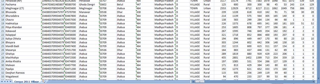
9 Digital Maps & Data for Geo-Marketing Population Data according to Census 2011
10 Digital Maps for Geo-Marketing Landuse\Landcover Map of India o Residential Areas o o o Commercial Areas Industrial Areas Other areas
11 Presentation Outline About Excel Geomatics About Geo-marketing Digital Maps for Geo-marketing Population Distribution Model

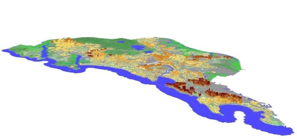
12 Population Distribution Model Raster grid based map showing the distribution of population Density of the population per pixel Population Distribution Model of Amritsar


13 Population Distribution Model Classification, Weightage & Data Processing Satellite Image Census 2011 Data Population Distribution Model
14 Visualization and Analysis AOI Based Analysis
15 Why Population Distribution Model? The population density of an area can be one of the most important determining factors for planning of business and marketing campaign. It s not enough only to know how many consumers live in a specific state or a city but it is also important to know how the distribution of population within a city, ward or even within a village is. Population Distribution Map' will allow planners to choose a location for a business that is accessible to the largest number of people. Using 'Population Distribution Model' it is possible to know the population within any buffer, boundary, or AOI
16 Visualization and Analysis Buffer Analysis
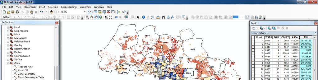
17 Visualization and Analysis Zonal Analysis
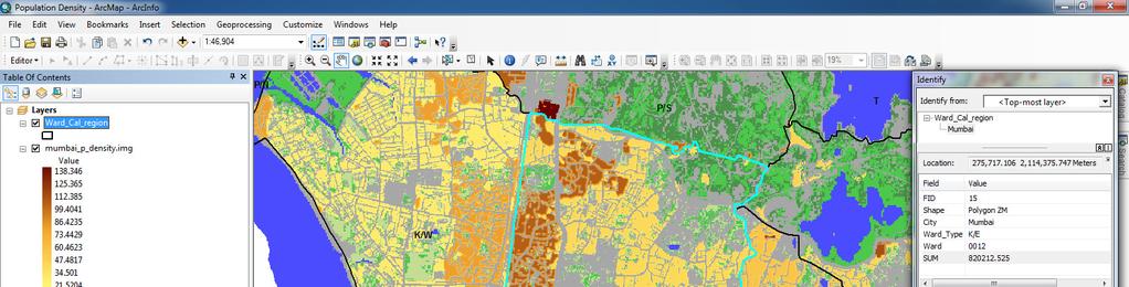
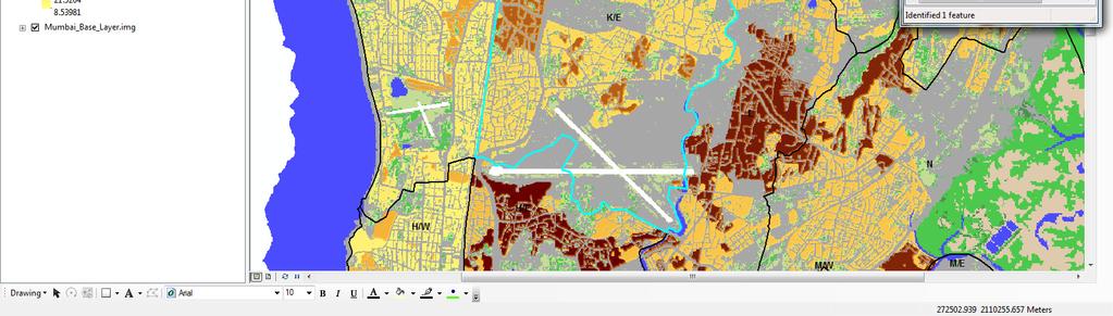
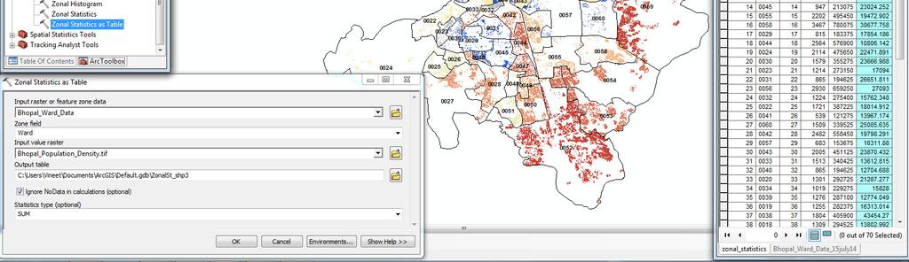
18 Visualization and Analysis Ward-wise Analysis
19 Geo-marketing Applications of Population Distribution Model This map has found its usefulness in the business application areas such as o Selection of ATM location based on the population that could be covered within a buffer zone o Allotment of franchises or opening of a retail outlet based on covered and not by the distance between them population o To know the approximate population covered by signals from each Telecom Tower, etc..
20 Case Study 1: Buffer Analysis for Proposed ATM Sites
21 Case Study 2: Population in Telecom Cell Service Area


22 Case Study 3: Use of Population Distribution Model in Expansion of Restaurant Business
23 Thank You! w w w. e x c e l g e o m a t i c s. c o m
Excel Geomatics: Offering Excellence with Unique Consultancy & Services
 Excel Geomatics: Offering Excellence with Unique Consultancy & Services Providing consultancy and value Added Services using Remote Sensing, Photogrammetry and LiDAR in areas such as Agriculture, Forestry,
SOLUTIONS ADVANCED GIS. TekMindz are developing innovative solutions that integrate geographic information with niche business applications.
 ADVANCED GIS SOLUTIONS TekMindz are developing innovative solutions that integrate geographic information with niche business applications. TEK INDZ TM GIS Services Overview At the leading edge of geospatial
Land Administration and Cadastre
 Geomatics play a major role in hydropower, land and water resources and other infrastructure projects. Lahmeyer International s (LI) worldwide projects require a wide range of approaches to the integration
GEOMATICS. Shaping our world. A company of
 GEOMATICS Shaping our world A company of OUR EXPERTISE Geomatics Geomatics plays a mayor role in hydropower, land and water resources, urban development, transport & mobility, renewable energy, and infrastructure
Techniques for Science Teachers: Using GIS in Science Classrooms.
 Techniques for Science Teachers: Using GIS in Science Classrooms. After ESRI, 2008 GIS A Geographic Information System A collection of computer hardware, software, and geographic data used together for
8/28/2011. Contents. Lecture 1: Introduction to GIS. Dr. Bo Wu Learning Outcomes. Map A Geographic Language.
 Contents Lecture 1: Introduction to GIS Dr. Bo Wu lsbowu@polyu.edu.hk Department of Land Surveying & Geo-Informatics The Hong Kong Polytechnic University 1. Learning outcomes 2. GIS definition 3. GIS examples
Introduction to GIS. Dr. M.S. Ganesh Prasad
 Introduction to GIS Dr. M.S. Ganesh Prasad Department of Civil Engineering The National Institute of Engineering, MYSORE ganeshprasad.nie@gmail.com 9449153758 Geographic Information System (GIS) Information
Cartographic and Geospatial Futures
 Cartographic and Geospatial Futures 1. Web Cartography, WebGIS, & Virtual Globes--New Roles for Maps, GIS, and GIS professionals 2. Map Mashups, the Neo Neo-geography Movement, & Crowd-sourcing Geospatial
INTRODUCTION TO GEOGRAPHIC INFORMATION SYSTEM By Reshma H. Patil
 INTRODUCTION TO GEOGRAPHIC INFORMATION SYSTEM By Reshma H. Patil ABSTRACT:- The geographical information system (GIS) is Computer system for capturing, storing, querying analyzing, and displaying geospatial
STEREO ANALYST FOR ERDAS IMAGINE Stereo Feature Collection for the GIS Professional
 STEREO ANALYST FOR ERDAS IMAGINE Stereo Feature Collection for the GIS Professional STEREO ANALYST FOR ERDAS IMAGINE Has Your GIS Gone Flat? Hexagon Geospatial takes three-dimensional geographic imaging
GIS = Geographic Information Systems;
 What is GIS GIS = Geographic Information Systems; What Information are we talking about? Information about anything that has a place (e.g. locations of features, address of people) on Earth s surface,
Putting the U.S. Geospatial Services Industry On the Map
 Putting the U.S. Geospatial Services Industry On the Map December 2012 Definition of geospatial services and the focus of this economic study Geospatial services Geospatial services industry Allow consumers,
REIS: A spatial decision system for land valuation
 19 REIS: A spatial decision system for land valuation Himanshu Deshmukh 1, Rupali Khare 2, Kamal Pandey 1 and Dheeraj Kumar 2 1 Indian Institute of Remote Sensing, Dehradun 2 Indian School of Mines, Dhanbad
Introduction to GIS. Geol 4048 Geological Applications of Remote Sensing
 Introduction to GIS Geol 4048 Geological Applications of Remote Sensing GIS History: Before Computers GIS History Using maps for a long time Dr. Roger F. Tomlinson Father of GIS He was an English geographer
LandScan Global Population Database
 LandScan Global Population Database The World s Finest Population Distribution Data Uncommon information. Extraordinary places. LandScan Global Population Database East View Cartographic is now offering
Analysis of Future Urban Growth Scenario of Damaturu Town in Yobe State, Nigeria
 Review Article Analysis of Future Urban Growth Scenario of Damaturu Town in Yobe State, Nigeria Muhammad Isma il* 1, Ibrahim Jaro Musa 1 and Ahmed Abubakar Jajere 2 1 Department of Geography, Ahmadu Bello
Using Geographical Information System Techniques for Finding Appropriate Location for opening up a new retail site
 Using Geographical Information System Techniques for Finding Appropriate Location for opening up a new retail site Harpreet Rai Assistant Professor Department of computer applications SASIIT&R, Mohali
Global Data Catalog initiative Christophe Charpentier ArcGIS Content Product Manager
 Global Data Catalog initiative Christophe Charpentier ArcGIS Content Product Manager ccharpentier@esri.com We are in a global economy Global Economy Business and Operations are now global Strategic need
ENV208/ENV508 Applied GIS. Week 1: What is GIS?
 ENV208/ENV508 Applied GIS Week 1: What is GIS? 1 WHAT IS GIS? A GIS integrates hardware, software, and data for capturing, managing, analyzing, and displaying all forms of geographically referenced information.
Understanding China Census Data with GIS By Shuming Bao and Susan Haynie China Data Center, University of Michigan
 Understanding China Census Data with GIS By Shuming Bao and Susan Haynie China Data Center, University of Michigan The Census data for China provides comprehensive demographic and business information
GIS and Remote Sensing
 Spring School Land use and the vulnerability of socio-ecosystems to climate change: remote sensing and modelling techniques GIS and Remote Sensing Katerina Tzavella Project Researcher PhD candidate Technology
Zambia: A financial landscape ripe with opportunity May 11, 2016
 Zambia: A financial landscape ripe with opportunity May 11, 2016 www.themix.org 1 An ecosystem to develop the Digital Finance sector and to support all stakeholders Policy and regulation Customer Adoption
Geospatial Technologies
 An Overview of Prepared by: John McGee Jennifer McKee With support from: NSF DUE-0903270 in partnership with: Geospatial Technician Education Through Virginia s Community Colleges (GTEVCC) What is Geospatial?
Compact guides GISCO. Geographic information system of the Commission
 Compact guides GISCO Geographic information system of the Commission What is GISCO? GISCO, the Geographic Information System of the COmmission, is a permanent service of Eurostat that fulfils the requirements
Cadcorp Introductory Paper I
 Cadcorp Introductory Paper I An introduction to Geographic Information and Geographic Information Systems Keywords: computer, data, digital, geographic information systems (GIS), geographic information
Are You Maximizing The Value Of All Your Data?
 Are You Maximizing The Value Of All Your Data? Using The SAS Bridge for ESRI With ArcGIS Business Analyst In A Retail Market Analysis SAS and ESRI: Bringing GIS Mapping and SAS Data Together Presented
Esri and GIS Education
 Esri and GIS Education Organizations Esri Users 1,200 National Government Agencies 11,500 States & Regional Agencies 30,800 Cities & Local Governments 32,000 Businesses 8,500 Utilities 12,600 NGOs 11,000
GEOSPATIAL DATA OFFERINGS. April 2018
 GEOSPATIAL DATA OFFERINGS April 2018 Introduction Data cannot be explanatory until converted into information. Noteworthy to say a picture can cover more than 1000 words and a map can portray more than
GIS AND GEOSPATIAL INFORMATION MANAGEMENT FOR URBAN PLANNING AND LAND MANAGEMENT IN SAUDI ARABIA
 GIS AND GEOSPATIAL INFORMATION MANAGEMENT FOR URBAN PLANNING AND LAND MANAGEMENT IN SAUDI ARABIA Manal Al-Hajji GIS Consultant Oman Geospatial Forum Oman April 10-11, 2017 CONTENTS 1. Future Saudi Cities
Building a National Data Repository
 Building a National Data Repository Mladen Stojic, Vice President - Geospatial 1/30/2013 2012 Intergraph Corporation 1 Information has meaning and gives power only when shared and distributed. Information,
An Introduction to Geographic Information System
 An Introduction to Geographic Information System PROF. Dr. Yuji MURAYAMA Khun Kyaw Aung Hein 1 July 21,2010 GIS: A Formal Definition A system for capturing, storing, checking, Integrating, manipulating,
INVESTIGATING GEOGRAPHICAL ISSUES SAMPLE ASSESSMENT MATERIALS
 GCSE GEOGRAPHY B Sample Assessment Materials 5 GCSE GEOGRAPHY B COMPONENT 1 INVESTIGATING GEOGRAPHICAL ISSUES SAMPLE ASSESSMENT MATERIALS 1 hour 45 minutes For examiner s use only Q.1 32 SPaG 4 Q.2 32
Trip Generation Model Development for Albany
 Trip Generation Model Development for Albany Hui (Clare) Yu Department for Planning and Infrastructure Email: hui.yu@dpi.wa.gov.au and Peter Lawrence Department for Planning and Infrastructure Email: lawrence.peter@dpi.wa.gov.au
Internet based Dairy Geographical Information System (i-dgis) for Milk Unions & Federations. Sectoral Analysis & Studies Group, NDDB, Anand
 for Milk Unions & Federations. Sectoral Analysis & Studies Group, NDDB, Anand") Internet based Dairy Geographical Information System (i-dgis) for Milk Unions & Federations Sectoral Analysis & Studies Group, NDDB, Anand Knowing the physical location of the covered villages on the digital
Internet based Dairy Geographical Information System (i-dgis) for Milk Unions & Federations Sectoral Analysis & Studies Group, NDDB, Anand Knowing the physical location of the covered villages on the digital
Advanced Image Analysis in Disaster Response
 Advanced Image Analysis in Disaster Response Creating Geographic Knowledge Thomas Harris ITT The information contained in this document pertains to software products and services that are subject to the
GEOMATICS SURVEYING AND MAPPING EXPERTS FOR OVER 35 YEARS
 GEOMATICS SURVEYING AND MAPPING EXPERTS FOR OVER 35 YEARS 2 GEOMATICS AND SURVEYING SOLUTIONS SPANNING THE ENTIRE PROJECT LIFECYCLE 1,000+ 250+ 24 Surveying professionals Active field crews Geomatics offices
What is GIS? Introduction to data. Introduction to data modeling
 What is GIS? Introduction to data Introduction to data modeling 2 A GIS is similar, layering mapped information in a computer to help us view our world as a system A Geographic Information System is a
Exploring GIS Potential for Northwestern Ontario Land Information Ontario
 Exploring GIS Potential for Northwestern Ontario Land Information Ontario May 13, 2015 The LIO Vision LIO Vision: That all geographic information about Ontario is fully integrated and accessible LIO Goal:
Chapter : 1 : Introduction of GIS
 History of GIS : Chapter : 1 : Introduction of GIS In 1960 the Department of Forestry and Rural Department of Canada has decided to pursue a large-scale project to manage the resources. The initial task
The National Spatial Strategy
 Purpose of this Consultation Paper This paper seeks the views of a wide range of bodies, interests and members of the public on the issues which the National Spatial Strategy should address. These views
GEOGRAPHY. Parts/Units Topics Marks. Part A Fundamentals of Human Geography 35. Map Work 5. Part B India: People and Economy 35
 GEOGRAPHY Course Structure Parts/Units Topics Marks Part A Fundamentals of Human Geography 35 Unit 1 Unit 2 Unit 3 Unit 4 Unit 5 Human Geography People Human Activities Transport, Communication & Trade
Egypt Public DSS. the right of access to information. Mohamed Ramadan, Ph.D. [R&D Advisor to the president of CAPMAS]
![Egypt Public DSS. the right of access to information. Mohamed Ramadan, Ph.D. [R&D Advisor to the president of CAPMAS]](/thumbs/89/98483713.jpg "Egypt Public DSS. the right of access to information. Mohamed Ramadan, Ph.D. [R&D Advisor to the president of CAPMAS]") Egypt Public DSS ì the right of access to information Central Agency for Public Mobilization and Statistics Arab Republic of Egypt Mohamed Ramadan, Ph.D. [R&D Advisor to the president of CAPMAS] Egypt
Egypt Public DSS ì the right of access to information Central Agency for Public Mobilization and Statistics Arab Republic of Egypt Mohamed Ramadan, Ph.D. [R&D Advisor to the president of CAPMAS] Egypt
Georeferencing and Satellite Image Support: Lessons learned, Challenges and Opportunities
 Georeferencing and Satellite Image Support: Lessons learned, Challenges and Opportunities Shirish Ravan shirish.ravan@unoosa.org UN-SPIDER United Nations Office for Outer Space Affairs (UNOOSA) UN-SPIDER
Second High Level Forum on GGIM Seminar on Regional Cooperation in Geospatial Information Management Doha, Qatar, 7 February 2013
 Second High Level Forum on GGIM Seminar on Regional Cooperation in Geospatial Information Management Doha, Qatar, 7 February 2013 Overview on Geospatial Activities in Egypt BY : Eng.Nahla Seddik Mohamed
Services.
 1 Transport Analysis & Modeling Over the course of a decade, Masterconcept has gained a wide range of experience in the field of transport master planning, with a special emphasis on regional and urban
1994: JV formed for civil engineering consultancy COWI/KX A/s, Denmark(51%) IFU, Denmark (24% ) IL&FS Infrastructure Dev Corp, India(25%)
 IFU, Denmark (24% ) IL&FS Infrastructure Dev Corp, India(25%)") Company Profile 1994: JV formed for civil engineering consultancy COWI/KX A/s, Denmark(51%) IFU, Denmark (24% ) IL&FS Infrastructure Dev Corp, India(25%) 1998: Start of mapping as a new segment of Business.
Company Profile 1994: JV formed for civil engineering consultancy COWI/KX A/s, Denmark(51%) IFU, Denmark (24% ) IL&FS Infrastructure Dev Corp, India(25%) 1998: Start of mapping as a new segment of Business.
ADCC Infocad Pvt. Ltd.
 Introduction ADCC Infocad Pvt. Ltd (an ISO 9001: 2000 Certified GIS Company) is the leading GIS solution provider in Central India. The company boasts of state of the art infrastructure including a 10,000
LEO Catchment Profile (LCP) Key Data for Enterprise Strategy
 Key Data for Enterprise Strategy") Laois...Portarlington LEO Catchment Profile (LCP) Key Data for Enterprise Strategy Laois Local Enterprise Office Address: Business Support Unit, County Hall, Portlaoise, County Laois Web: https://www.localenterprise.ie/laois/
Laois...Portarlington LEO Catchment Profile (LCP) Key Data for Enterprise Strategy Laois Local Enterprise Office Address: Business Support Unit, County Hall, Portlaoise, County Laois Web: https://www.localenterprise.ie/laois/
Providing Public Access to King County GIS Data. Presented by: Michael Jenkins King County GIS Center Seattle, WA
 Providing Public Access to King County GIS Data Presented by: Michael Jenkins King County GIS Center Seattle, WA King County, Washington Microsoft Boeing Amazon.Com Starbucks Port of Seattle Weyerhauser
How GIS can be used for improvement of literacy and CE programmes
 How GIS can be used for improvement of literacy and CE programmes Training Workshop for Myanmar Literacy Resource Center (MLRC) ( Yangon, Myanmar, 11 20 October 2000 ) Presented by U THEIN HTUT GEOCOMP
Presented to Sub-regional workshop on integration of administrative data, big data and geospatial information for the compilation of SDG indicators
 Presented to Sub-regional workshop on integration of administrative data, big data and geospatial information for the compilation of SDG indicators 23-25 April,2018 Addis Ababa, Ethiopia By: Deogratius
Selection of the Most Suitable Locations for Telecommunication Services in Khartoum
 City and Regional Planning Term Project Final Report Selection of the Most Suitable Locations for Telecommunication Services in Khartoum By Amir Abdelrazig Merghani (ID:g201004180) and Faisal Mukhtar (ID:
geographic patterns and processes are captured and represented using computer technologies
 Proposed Certificate in Geographic Information Science Department of Geographical and Sustainability Sciences Submitted: November 9, 2016 Geographic information systems (GIS) capture the complex spatial
GIS and Remote Sensing Support for Evacuation Analysis
 GIS and Remote Sensing Support for Evacuation Analysis Presented to GIS for Transportation Symposium Rapid City, South Dakota March 28-31, 2004 Demin Xiong Oak Ridge National Laboratory 2360 Cherahala
Augmented Reality Market Research Report- Global Forecast till 2023
 Report Information More information from: https://www.marketresearchfuture.com/reports/1143 Augmented Reality Market Research Report- Global Forecast till 2023 Report / Search Code: MRFR/ICT/0637-HCRR
Urban Spatial Scenario Design Modelling (USSDM) in Dar es Salaam: Background Information
 in Dar es Salaam: Background Information") Urban Spatial Scenario Design Modelling (USSDM) in Dar es Salaam: Background Information Modelling urban settlement dynamics in Dar es Salaam Revision: 2 (July 2013) Prepared by: Katja Buchta TUM team
Urban Spatial Scenario Design Modelling (USSDM) in Dar es Salaam: Background Information Modelling urban settlement dynamics in Dar es Salaam Revision: 2 (July 2013) Prepared by: Katja Buchta TUM team
Urban Expansion and Loss of Agricultural Land: A Remote Sensing Based Study of Shirpur City, Maharashtra
 Cloud Publications International Journal of Advanced Remote Sensing and GIS 2017, Volume 6, Issue 1, pp. 2097-2102 ISSN 2320 0243, Crossref: 10.23953/cloud.ijarsg.113 Research Article Open Access Urban
USING GIS CARTOGRAPHIC MODELING TO ANALYSIS SPATIAL DISTRIBUTION OF LANDSLIDE SENSITIVE AREAS IN YANGMINGSHAN NATIONAL PARK, TAIWAN
 CO-145 USING GIS CARTOGRAPHIC MODELING TO ANALYSIS SPATIAL DISTRIBUTION OF LANDSLIDE SENSITIVE AREAS IN YANGMINGSHAN NATIONAL PARK, TAIWAN DING Y.C. Chinese Culture University., TAIPEI, TAIWAN, PROVINCE
INTERNATIONAL JOURNAL OF GEOMATICS AND GEOSCIENCES Volume 2, No 1, 2011
 INTERNATIONAL JOURNAL OF GEOMATICS AND GEOSCIENCES Volume 2, No 1, 2011 Copyright 2010 All rights reserved Integrated Publishing services Research article ISSN 0976 4380 Spatio-Temporal changes of Land
THE USE OF GEOMATICS IN CULTURAL HERITAGE AND ARCHAEOLOGY FOR VARIOUS PURPOSES
 THE USE OF GEOMATICS IN CULTURAL HERITAGE AND ARCHAEOLOGY FOR VARIOUS PURPOSES FEBRUARY 2013 AL BEIDA GEOPLAN CONTENT Company Profile Concept Objectives and Strategies Data Production Methods Data Samples
ASSESSMENT. Industry Solutions Harness the Power of GIS for Property Assessment
 ASSESSMENT Industry Solutions Harness the Power of GIS for Property Assessment Esri Canada has thousands of customers worldwide who are using the transforming power of GIS technology to collect, maintain,
Applications: Introduction Task 1: Introduction to ArcCatalog Task 2: Introduction to ArcMap Challenge Question References
 CHAPTER 1 INTRODUCTION 1.1 GIS? 1.1.1 Components of a GIS 1.1.2 A Brief History of GIS 1.1.3 GIS Software Products Box 1.1 A List of GIS Software Producers and Their Main Products 1.2 GIS Applications
Site Suitability Analysis for Urban Development: A Review
 Site Suitability Analysis for Urban Development: A Review Santanu Kumar Misra Associate Professor (Dept. of CSE) Sikkim Manipal Institute of Technology Majitar, Sikkim misra_santanu@rediffmail.com Shrijana
Topic 4: Changing cities
 Topic 4: Changing cities Overview of urban patterns and processes 4.1 Urbanisation is a global process a. Contrasting trends in urbanisation over the last 50 years in different parts of the world (developed,
Globally Estimating the Population Characteristics of Small Geographic Areas. Tom Fitzwater
 Globally Estimating the Population Characteristics of Small Geographic Areas Tom Fitzwater U.S. Census Bureau Population Division What we know 2 Where do people live? Difficult to measure and quantify.
International Journal of Advancements in Research & Technology, Volume 2, Issue 7, July ISSN
 International Journal of Advancements in Research & Technology, Volume 2, Issue 7, July-2013 34 Remote Sensing & GIS Tools for Urban Studies in Akola city, Maharashtra. Khadri, S.F.R Chaitanya Pande and
The Journal of Database Marketing, Vol. 6, No. 3, 1999, pp Retail Trade Area Analysis: Concepts and New Approaches
 Retail Trade Area Analysis: Concepts and New Approaches By Donald B. Segal Spatial Insights, Inc. 4938 Hampden Lane, PMB 338 Bethesda, MD 20814 Abstract: The process of estimating or measuring store trade
Careers in downstream satellite applications. Michael Lawrence Business Development Director. Deimos Space UK
 Careers in downstream satellite applications Michael Lawrence Business Development Director Deimos Space UK 1 Agenda 1. What is the downstream sector? 2. What kinds of jobs are available? 3. What do you
R E SEARCH HIGHLIGHTS
 Canada Research Chair in Urban Change and Adaptation R E SEARCH HIGHLIGHTS Research Highlight No.8 November 2006 THE IMPACT OF ECONOMIC RESTRUCTURING ON INNER CITY WINNIPEG Introduction This research highlight
Creating synergies between Statistical and Geospatial information for better policy outputs: The case of Mexico
 Creating synergies between Statistical and Geospatial information for better policy outputs: The case of Mexico Geospatial & Statistics Integration for Informed Decision Making Geospatial World Forum 2017
GIS AS A TOOL FOR MINERAL EXPLORATION
 GIS AS A TOOL FOR MINERAL EXPLORATION By Njagi Dennis Muriithi I13/3169/2008 SGL 413: PROJECT IN GEOLOGY Course coordinators: Dr. C. M. Gichaba Dr. E. Dindi Supervisor: Dr. C. M. Gichaba OUTLINE Introduction
UNITED NATIONS E/CONF.96/CRP. 5
 UNITED NATIONS E/CONF.96/CRP. 5 ECONOMIC AND SOCIAL COUNCIL Eighth United Nations Regional Cartographic Conference for the Americas New York, 27 June -1 July 2005 Item 5 of the provisional agenda* COUNTRY
Establishing the National Spatial Data Infrastructure (NSDI) for Norway a joint effort by many stakeholders SPATIAL DATA FOR BENEFIT OF THE SOCIETY
 for Norway a joint effort by many stakeholders SPATIAL DATA FOR BENEFIT OF THE SOCIETY") Establishing the National Spatial Data Infrastructure (NSDI) for Norway a joint effort by many stakeholders SPATIAL DATA FOR THE BENEFIT OF SOCIETY OUTLINE Political background Norway digital - The Norwegian
Establishing the National Spatial Data Infrastructure (NSDI) for Norway a joint effort by many stakeholders SPATIAL DATA FOR THE BENEFIT OF SOCIETY OUTLINE Political background Norway digital - The Norwegian
GIS VISION INDIA. GIS (Geographic Information System) Training, Mapping and Services. Nature is the source of all true knowledge,
 Training, Mapping and Services. Nature is the source of all true knowledge,") GIS (Geographic Information System) Training, Mapping and Services Nature is the source of all true knowledge, She has neither effect without cause nor invention without necessity -Leonardo da vinci Career
GIS (Geographic Information System) Training, Mapping and Services Nature is the source of all true knowledge, She has neither effect without cause nor invention without necessity -Leonardo da vinci Career
Saskatoon Region Economic Diversity Report
 Saskatoon Region Economic Diversity Report Economic Diversity: Empirical Calculations and Comparisons In order to analyse the economic diversity of the Saskatoon Region, we first had to answer a few questions:
Advanced Algorithms for Geographic Information Systems CPSC 695
 Advanced Algorithms for Geographic Information Systems CPSC 695 Think about Geography What is Geography The 3 W s of Geography What is where Why is it there Why do I care Data - Data - Data We all got
Remote Sensing and EO activities at the University of Turku
 Remote Sensing and EO activities at the University of Turku Niina Käyhkö Associate Professor Department of Geography and Geology GEO meeting/syke May 23rd, 2018 Geospatial competence at the University
Exploit your geodata to enable smart cities and countries
 Exploit your geodata to enable smart cities and countries Carsten Rönsdorf, Head of Advisory Services Middle East Practice Manager Future Cities, standards and 3D 24 November 2014 Importance of Standards
Bentley Map Advancing GIS for the World s Infrastructure
 Bentley Map Advancing GIS for the World s Infrastructure Presentation Overview Why would you need Bentley Map? What is Bentley Map? Where is Bentley Map Used? Why would you need Bentley Map? Because your
Spatial Analysis of Natural Hazard and Climate Change Risks in Peri-Urban Expansion Areas of Dakar, Senegal
 1 Spatial Analysis of Natural Hazard and Climate Change Risks in Peri-Urban Expansion Areas of Dakar, Senegal URBAN WEEK 2009 BBL Preston Lounge Thursday, March 12, 2009 Christian Hoffmann GeoVille group
Semester Project Final Report. Logan River Flood Plain Analysis Using ArcGIS, HEC-GeoRAS, and HEC-RAS
 Semester Project Final Report Logan River Flood Plain Analysis Using ArcGIS, HEC-GeoRAS, and HEC-RAS Kedric Curtis, Josh Hogge, Jordan Jarrett, Jared Justensen May 6, 2016 CEE 6190 GIS for Civil Engineers
Purpose Study conducted to determine the needs of the health care workforce related to GIS use, incorporation and training.
 GIS and Health Care: Educational Needs Assessment Cindy Gotz, MPH, CHES Janice Frates, Ph.D. Suzanne Wechsler, Ph.D. Departments of Health Care Administration & Geography California State University Long
Geometric Algorithms in GIS
 Geometric Algorithms in GIS GIS Visualization Software Dr. M. Gavrilova GIS Software for Visualization ArcView GEO/SQL Digital Atmosphere AutoDesk Visual_Data GeoMedia GeoExpress CAVE? Visualization in
Bridging the Gap between Engineering and GIS
 Bridging the Gap between Engineering and GIS Presented by: Karen Stewart, B.Tech, GISP Manager of Geomatics Township of Langley February 13, 2006 Agenda Introduction History Goals Implementation Benefits
- World-wide cities are growing at a rate of 2% annually (UN 1999). - (60,3%) will reside in urban areas in 2030.
. - (60,3%) will reside in urban areas in 2030.") THE EFFECTIVENESS OF NEW TECHNOLOGIES FOR URBAN LAND MANAGEMENT BAHAAEDDINE I. AL HADDAD Centro de Política de Suelo y Valoraciones Universidad Politécnica de Cataluña Barcelona, España www.upc.es/cpsv
THE EFFECTIVENESS OF NEW TECHNOLOGIES FOR URBAN LAND MANAGEMENT BAHAAEDDINE I. AL HADDAD Centro de Política de Suelo y Valoraciones Universidad Politécnica de Cataluña Barcelona, España www.upc.es/cpsv
Louisiana Transportation Engineering Conference. Monday, February 12, 2007
 Louisiana Transportation Engineering Conference Monday, February 12, 2007 Agenda Project Background Goal of EIS Why Use GIS? What is GIS? How used on this Project Other site selection tools I-69 Corridor
Fundamental Geospatial Datasets in Africa. Andre Nonguierma New York, 03 August 2015
 Fundamental Geospatial Datasets in Africa United Nations Economic Commission for Africa Geoinformation & Spatial Statistics Andre Nonguierma New York, 03 August 2015 Core Data : Lack of consistency Infrastructure
The Trade Area Analysis Model
 The Trade Area Analysis Model Trade area analysis models encompass a variety of techniques designed to generate trade areas around stores or other services based on the probability of an individual patronizing
Methodological issues in the development of accessibility measures to services: challenges and possible solutions in the Canadian context
 Methodological issues in the development of accessibility measures to services: challenges and possible solutions in the Canadian context Alessandro Alasia 1, Frédéric Bédard 2, and Julie Bélanger 1 (1)
Track 1: From CRM to decision support. Steven Halsall, Director, GeoBusiness Solutions Ltd
 the agi conference at GIS 2001 Track 1: From CRM to decision support t1.4 Identifying the Real Catchments of UK Shopping Locations Steven Halsall, Director, GeoBusiness Solutions Ltd Abstract One of the
GIS BASED ANALYSIS ON ENVIRONMENTAL SENSITIVE AREAS AND IDENTIFICATION OF THE POTENTIAL DISASTER HAZARDOUS LOCATIONS IN SOUTHERN SRI LANKA
 International Journal of Civil & Environmental Engineering IJCEE Vol: 9 No: 9-311 - GIS BASED ANALYSIS ON ENVIRONMENTAL SENSITIVE AREAS AND IDENTIFICATION OF THE POTENTIAL DISASTER HAZARDOUS LOCATIONS
Data Visualization and Evaluation
 Data Visualization and Evaluation Juan Paulo Ramírez, Ph.D. University of Nebraska 5th Annual Environmental Evaluators Networking Forum June 2010 Purpose and Objectives Purpose Introduce to program evaluators
Yaneev Golombek, GISP. Merrick/McLaughlin. ESRI International User. July 9, Engineering Architecture Design-Build Surveying GeoSpatial Solutions
 Yaneev Golombek, GISP GIS July Presentation 9, 2013 for Merrick/McLaughlin Conference Water ESRI International User July 9, 2013 Engineering Architecture Design-Build Surveying GeoSpatial Solutions Purpose
Google Maps and Beyond
 Google Maps and Beyond Aaron Paul First American Title apaul@firstam.com 2015 APRA Symposium Association of Professional Reserve Analysts May 2 nd, 2015 Google Maps and Beyond - Overview Business case
GIS Products & Solutions
 GIS Products & Solutions We aim at providing our client with the best in GIS and Remote Sensing. We have an experience of ten years of working and associations of some of the best organizations in the
CENSUS MAPPING WITH GIS IN NAMIBIA. BY Mrs. Ottilie Mwazi Central Bureau of Statistics Tel: October 2007
 CENSUS MAPPING WITH GIS IN NAMIBIA BY Mrs. Ottilie Mwazi Central Bureau of Statistics E-mail: omwazi@npc.gov.na Tel: + 264 61 283 4060 October 2007 Content of Presentation HISTORICAL BACKGROUND OF CENSUS
indigeo Consultants Pvt Ltd Geophysical Surveys Geological Surveys GIS & Data Solutions Image Processing indigeo Company Profile, Page 1
 indigeo Consultants Pvt Ltd Geophysical Surveys Geological Surveys GIS & Data Solutions Image Processing MM Corner, 3 rd Floor #58, Banaswadi Main Road Bangalore 560033 INDIA Ph: +91 80 41638310 Mob: +91
A Broad View of Geospatial Technology & Systems
 A Broad View of Geospatial Technology & Systems Pete Large Vice President, Trimble On the shoulders of giants 1 Since their time, our ability to generate geospatial information has grown exponentially
What is GIS? G: Geographic, Geospatial, Geo
 GEOG 488/588: GIS I Introduction Instructor: Geoffrey Duh TA: David Graves What is GIS? G: Geographic, Geospatial, Geo Alternatives: Spatial Information Systems, Land Information Systems Geography diverse
COURSE INTRODUCTION & COURSE OVERVIEW
 week 1 COURSE INTRODUCTION & COURSE OVERVIEW topics of the week Instructor introduction Students introductions Course logistics Course objectives Definition of GIS The story of GIS introductions Who am