Careers in downstream satellite applications. Michael Lawrence Business Development Director. Deimos Space UK
|
|
|
- Gervase Webster
- 6 years ago
- Views:
Transcription


1 Careers in downstream satellite applications Michael Lawrence Business Development Director Deimos Space UK 1

2 Agenda 1. What is the downstream sector? 2. What kinds of jobs are available? 3. What do you need to be doing to get into the sector? All Rights Reserved. No part of this document may be reproduced, stored, or transmitted, without the prior written permission of DEIMOS Space UK (Image Deimos Imaging) 2
 21 staff in UK, 350+ staff in Spain, Portugal and Romania Based at Harwell Experts in")


3 Deimos Space UK A subsidiary of the Spanish satellite technology company Elecnor Deimos (part of the Elecnor group) 21 staff in UK, 350+ staff in Spain, Portugal and Romania Based at Harwell Experts in satellite software and systems engineering Flight Segment Guidance, Navigation and Control Ground Segment Space Situational Awareness Global Navigation Satellite Systems Earth Observation Satellite Applications Location Based Services All Rights Reserved. No part of this document may be reproduced, stored, or transmitted, without the prior written permission of DEIMOS Space UK (Image Deimos Imaging) 3
4 The UK Space Economy Upstream Space Transportation Ground Segment Manufacturing Research and Consultancy All Rights Reserved. No part of this document may be reproduced, stored, or transmitted, without the prior written permission of DEIMOS Space UK 4
5 The UK Space Economy Upstream Downstream Space Transportation Ground Segment Manufacturing Research and Consultancy Financial Services Broadcasting Communications Defence Earth Observation Navigation Science All Rights Reserved. No part of this document may be reproduced, stored, or transmitted, without the prior written permission of DEIMOS Space UK 5
6 The UK Space Economy Wider Space Economy Upstream Space Transportation Ground Segment Manufacturing Research and Consultancy Downstream Financial Services Broadcasting Communications Defence Earth Observation Navigation Science All Rights Reserved. No part of this document may be reproduced, stored, or transmitted, without the prior written permission of DEIMOS Space UK Broadcasting TV and Radio content Communications Disaster recovery Telemedicine Oil and Gas exploration Defence Surveillance Earth Observation Meteorology Mapping Border control Environmental protection Navigation Road navigation and telematics Location Based Services Precision agriculture Surveying and construction 6


7 Size of the UK downstream industry 2013/14 Upstream Downstream Turnover 1b 10b Employment 8,000 28,000 All Rights Reserved. No part of this document may be reproduced, stored, or transmitted, without the prior written permission of DEIMOS Space UK 7


8 Space Innovation and Growth Strategy The highest growth space markets over the next two decades will be in space-based services and applications using space data, services and infrastructure. The greatest challenge now is for the space industry to become more outward looking. It needs to reach out to other sectors of the UK and global economy that can benefit from space applications, data and services. The aim should be to create a space enabled economy where space components provide new advantages that lead to growth, new jobs and increased market share in areas not traditionally linked to space. All Rights Reserved. No part of this document may be reproduced, stored, or transmitted, without the prior written permission of DEIMOS Space UK 8


9 Land Cover Land Use CropID: Crop Classification Satellite data plus geometry of the field boundaries Apply machine learning algorithms Classify by choosing the most probable crop for each field

10 Land Cover Land Use CropID: Crop Classification - Field boundaries from the Rural Payments Agency - Satellite imagery: DMC-2/Deimos-1 satellite imagery (22m) Tested with RapidEye (5m) 3 images through the year, covering beginning, middle and end of growing season are preferred - Supervised classification Field survey to collect ground data: 2000 fields visited Support Vector Machine and Random Forest used for classification, taking the best result for each crop


11 Land Cover Land Use CropID: Example 11


12 Precision agriculture - KORE Augmenting a precision agriculture service using Satellite and UAV Earth Observation imagery to provide cost effective crop management advice 12


13 Precision agriculture - KORE Planning for variable rate application of crop inputs Crop change detection Identifying weeds in crops Assessment of yield Plant counting 13


14 Precision agriculture KORE Potato plant counting Counted: 1672 plants 14


15 SAFIY project Smart Application for Feature extraction & 3D modelling using high-resolution satellite Imagery partnership with Mohammed bin Rashid Space Centre, Dubai 15


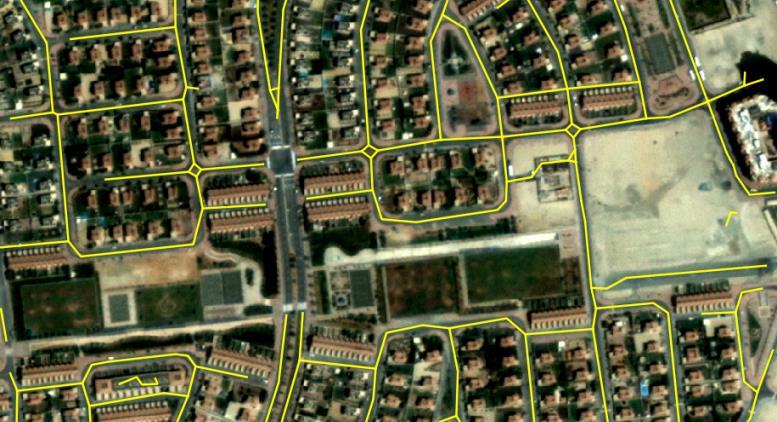
16 SAFIY objective Automatically update maps in Dubai using highresolution satellite imagery 16
 Bands: Red Green Blue Near Infrared When new images arrive: Detect roads Compare with current road network Find")
17 Urban - Roads The existing road network is known and available in vector format Using high-resolution imagery from Deimos-2 and Dubaisat-2 (1m) Bands: Red Green Blue Near Infrared When new images arrive: Detect roads Compare with current road network Find differences 17


18 Urban - Roads Satellite image + Training data Classification Road pixels Skeletonise Vectorise New vectors 18
19 Recent Deimos downstream vacancies Image Processing Engineer Experience of Image processing algorithms and feature extraction tools OGC Web interface (WMS, WCS, WFS) Software development using Python within AGILE teams (SCRUM) PostgreSQL, PostGIS GIS Engineer Experience of Geographic Information Systems e.g. ESRI ArcGIS Knowledge of Python or Java Experience of development using GeoServer Lead Software Engineer for Satellite Applications Experience of Java and/or C/C++ Familiarity with web frameworks and Linux deployment Experience of building Android or ios apps All Rights Reserved. No part of this document may be reproduced, stored, or transmitted, without the prior written permission of DEIMOS Space UK 19
20 Recent Deimos downstream candidates Image Processing Engineer Telecomms Engineering + Geoinformation and Remote Sensing GIS Engineer Environmental Science + GIS and Spatial Planning Lead Software Engineer for Satellite Applications Physics + Astronomical Technology All Rights Reserved. No part of this document may be reproduced, stored, or transmitted, without the prior written permission of DEIMOS Space UK 20
21 What makes you an attractive candidate for jobs in the downstream satellite sector? Relevant degree(s) + work experience - software development skills are important هل تتحدث العربية français?, Languages - hablas español?, parlez-vous Team work you will be part of a team Project Management you need to manage your work (and other people s work) Communication/ Presentation skills you need to be able to tell people about your work Finance you need to be aware of the business impact of your work All Rights Reserved. No part of this document may be reproduced, stored, or transmitted, without the prior written permission of DEIMOS Space UK 21
22 Summary 1. The downstream satellite applications sector is growing 2. A wide variety of jobs are available 3. You don t need to be a Physics graduate All Rights Reserved. No part of this document may be reproduced, stored, or transmitted, without the prior written permission of DEIMOS Space UK (Image Deimos Imaging) 22

23 Michael Lawrence Business Development Director Deimos Space UK
DEIMOS FOREIGN DIRECT INVESTMENT CASE IN UK
 DEIMOS FOREIGN DIRECT INVESTMENT CASE IN UK UK SPACE CONFERENCE EXPANDING FRONTIERS MAY 2017 Ismael López Deputy CEO @ElecnorDeimos All Rights Reserved No part of this document may be reproduced, stored,
Data Aggregation with InfraWorks and ArcGIS for Visualization, Analysis, and Planning
 Data Aggregation with InfraWorks and ArcGIS for Visualization, Analysis, and Planning Stephen Brockwell President, Brockwell IT Consulting, Inc. Join the conversation #AU2017 KEYWORD Class Summary Silos
GIS Workshop Data Collection Techniques
 GIS Workshop Data Collection Techniques NOFNEC Conference 2016 Presented by: Matawa First Nations Management Jennifer Duncan and Charlene Wagenaar, Geomatics Technicians, Four Rivers Department QA #: FRG
Exploit your geodata to enable smart cities and countries
 Exploit your geodata to enable smart cities and countries Carsten Rönsdorf, Head of Advisory Services Middle East Practice Manager Future Cities, standards and 3D 24 November 2014 Importance of Standards
METEOROLOGY What can I do with this major?
 METEOROLOGY What can I do with this major? WEATHER FORECASTING (non-media) Atmospheric pollution Aviation weather Marine weather Fire weather Surface transportation Agriculture Renewable energy Combat
Collaborative Systems for the Creation of Marine Services
 Collaborative Systems for the Creation of Marine Services INSPIRE 2016 Nuno Almeida Nuno Catarino Barcelona, 28 th September 2016 Elecnor Deimos is a trademark which encompasses Elecnor Group companies
How to Increase the Significance of your GIS
 How to Increase the Significance of your GIS Wade Kloos, GIS Director, Utah Department of Natural Resources wkloos@utah.gov 2014 Esri International User Conference July 17 How to Increase the Significance
European Space Agency
 Guidelines - Guidelines how/when to interact during the WebEx session: - Due to the number of attendees, please keep always your webcam and microphone switched-off - You can use anytime the chat to all
IMPLEMENTING GOVERNMENT-WIDE ENTERPRISE GIS; THE FEDERATED MODEL
 IMPLEMENTING GOVERNMENT-WIDE ENTERPRISE GIS; THE FEDERATED MODEL James E. Mitchell, Ph. D. IT GIS Manager Louisiana Department of Transportation and Development presented at the ESRI International Users
Globally Estimating the Population Characteristics of Small Geographic Areas. Tom Fitzwater
 Globally Estimating the Population Characteristics of Small Geographic Areas Tom Fitzwater U.S. Census Bureau Population Division What we know 2 Where do people live? Difficult to measure and quantify.
Corporate. Information. Railway Infrastructure Administrator. Year indracompany.com
 geospatial and mobility Corporate Geographic Information System of ADIF Railway Infrastructure Administrator. Year 2009-2010 Corporate Geographic Information System of ADIF ADIF. Spanish Administrator
gvsig: Open Source Solutions in spatial technologies
 gvsig: Open Source Solutions in spatial technologies gvsig is a tool for handling geographical information, a completely GIS client with license GNU GPL. Alvaro A. Anguix Alfaro, Gabriel Carrión Rico Conselleria
SOLUTIONS ADVANCED GIS. TekMindz are developing innovative solutions that integrate geographic information with niche business applications.
 ADVANCED GIS SOLUTIONS TekMindz are developing innovative solutions that integrate geographic information with niche business applications. TEK INDZ TM GIS Services Overview At the leading edge of geospatial
ArcGIS is Advancing. Both Contributing and Integrating many new Innovations. IoT. Smart Mapping. Smart Devices Advanced Analytics
 ArcGIS is Advancing IoT Smart Devices Advanced Analytics Smart Mapping Real-Time Faster Computing Web Services Crowdsourcing Sensor Networks Both Contributing and Integrating many new Innovations ArcGIS
Techniques for Science Teachers: Using GIS in Science Classrooms.
 Techniques for Science Teachers: Using GIS in Science Classrooms. After ESRI, 2008 GIS A Geographic Information System A collection of computer hardware, software, and geographic data used together for
The Emerging Role of Enterprise GIS in State Forest Agencies
 The Emerging Role of Enterprise GIS in State Forest Agencies Geographic Information System (GIS) A geographic information system (GIS) is a computer software system designed to capture, store, manipulate,
Commercialisation. Lessons learned from Dutch weather market
 Commercialisation Lessons learned from Dutch weather market Where information comes together weather traffic public transport Weather, traffic and public transport. Daily actual information that influences
Presented at the FIG Working Week 2017, May 29 - June 2, 2017 in Helsinki, Finland SURV. ISAAC OLORUNFEMI ADEDURIN MAY 2017
 Presented at the FIG Working Week 2017, May 29 - June 2, 2017 in Helsinki, Finland BY SURV. ISAAC OLORUNFEMI ADEDURIN 08023139029 MAY 2017 GEOGRAPHICAL COMPONENT DATABANK SECURITY DATABANK COMPONENT:
Increasing GI awareness in local authorities in Poland experiences from the INSPIRE Academy training programme
 Increasing GI awareness in local authorities in Poland experiences from the INSPIRE Academy training programme http://www.akademiainspire.pl Maria Andrzejewska, Monika Rusztecka UNEP/GRID-Warsaw Centre,
INSPIRing Geospatial Framework For Local Administrations
 This project is financed by the European Union and the Republic of Turkey Presented at the FIG Congress 2018, May 6-11, 2018 in Istanbul, Turkey National Programme for Turkey 2010 Instrument for Pre-Accession
Excel Geomatics. Rajesh Paul Excel Geomatics Pvt. Ltd., Noida February, 2015 India Geospatial Forum, Hyderabad
 Excel Geomatics Geo-marketing for Product Sales and Customer Services Rajesh Paul Excel Geomatics Pvt. Ltd., Noida 10-12 February, 2015 India Geospatial Forum, Hyderabad Presentation Outline About Excel
G EOSPAT I A L ERDAS IMAGINE. The world s most widely-used software package for creating information from geospatial data
 G EOSPAT I A L ERDAS IMAGINE The world s most widely-used software package for creating information from geospatial data ERDAS IMAGINE Geographic imaging professionals need to process vast amounts of
ENV208/ENV508 Applied GIS. Week 1: What is GIS?
 ENV208/ENV508 Applied GIS Week 1: What is GIS? 1 WHAT IS GIS? A GIS integrates hardware, software, and data for capturing, managing, analyzing, and displaying all forms of geographically referenced information.
Land Use in the context of sustainable, smart and inclusive growth
 Land Use in the context of sustainable, smart and inclusive growth François Salgé Ministry of sustainable development France facilitator EUROGI vice president AFIGéO board member 1 Introduction e-content+
Exploring GIS Potential for Northwestern Ontario Land Information Ontario
 Exploring GIS Potential for Northwestern Ontario Land Information Ontario May 13, 2015 The LIO Vision LIO Vision: That all geographic information about Ontario is fully integrated and accessible LIO Goal:
Are You on the Map for Geospatial Data Applications and Hosting?
 Are You on the Map for Geospatial Data Applications and Hosting? May 20, 2011 an East View update on happenings benefiting print, raster and vector geospatial data Rodney Buhrsmith, Chief Marketing Officer,
ArcGIS. for Server. Understanding our World
 ArcGIS for Server Understanding our World ArcGIS for Server Create, Distribute, and Manage GIS Services You can use ArcGIS for Server to create services from your mapping and geographic information system
Presentation by Thangavel Palanivel Senior Strategic Advisor and Chief Economist UNDP Regional Bureau for Asia-Pacific
 Presentation by Thangavel Palanivel Senior Strategic Advisor and Chief Economist UNDP Regional Bureau for Asia-Pacific The High-Level Euro-Asia Regional Meeting on Improving Cooperation on Transit, Trade
Development of a Web-Based GIS Management System for Agricultural Authorities in Iraq
 Development of a Web-Based GIS Management System for Agricultural Authorities in Iraq USCID Water Management Conference Phoenix, Arizona April 18, 2013 Gabriele Bonaiti Extension Program Specialist David
Innovation in mapping and photogrammetry at the Survey of Israel
 16, October, 2017 Innovation in mapping and photogrammetry at the Survey of Israel Yaron Felus and Ronen Regev Contents Why HD mapping? Government requirements Mapping regulations o Quality requirements
E-Government and SDI in Bavaria, Germany
 135 E-Government and SDI in Bavaria, Germany Wolfgang STOESSEL, Germany Key words: GDI-BY, Bavaria, Spatial Data Infrastructure SUMMARY Spatial Data Infrastructure (SDI) is an important part of the e-government
Cartographic and Geospatial Futures
 Cartographic and Geospatial Futures 1. Web Cartography, WebGIS, & Virtual Globes--New Roles for Maps, GIS, and GIS professionals 2. Map Mashups, the Neo Neo-geography Movement, & Crowd-sourcing Geospatial
GEOMATICS. Shaping our world. A company of
 GEOMATICS Shaping our world A company of OUR EXPERTISE Geomatics Geomatics plays a mayor role in hydropower, land and water resources, urban development, transport & mobility, renewable energy, and infrastructure
Land Administration and Cadastre
 Geomatics play a major role in hydropower, land and water resources and other infrastructure projects. Lahmeyer International s (LI) worldwide projects require a wide range of approaches to the integration
Remote sensing of forest and land cover at the AUA GIS & Remote Sensing Lab
 AUA GIS AND REMOTE SENSING LAB An initiative of the AUA Acopian Center for the Environment and the AUA College of Science and Engineering http://ace.aua.am/gis-and-remote-sensing Remote sensing of forest
Putting the U.S. Geospatial Services Industry On the Map
 Putting the U.S. Geospatial Services Industry On the Map December 2012 Definition of geospatial services and the focus of this economic study Geospatial services Geospatial services industry Allow consumers,
GIS Resources for Local Governments
 ISSUE PAPER SERIES GIS Resources for Local Governments February 2018 NEW YORK STATE TUG HILL COMMISSION DULLES STATE OFFICE BUILDING 317 WASHINGTON STREET WATERTOWN, NY 13601 (315) 785-2380 WWW.TUGHILL.ORG
DESIGNING AND APPLICATION OF WEB-BASED GEOGRAPHICAL INFORMATION SYSTEM FOR VISUAL ASSESSMENT OF LAND LEVELS
 DOI: 10.21917/ijsc.2018.0235 DESIGNING AND APPLICATION OF WEB-BASED GEOGRAPHICAL INFORMATION SYSTEM FOR VISUAL ASSESSMENT OF LAND LEVELS Ri NamSong, Choe JongAe and Kim Jonggun Institute of Information
Green Space Services for Local Monitoring
 Green Space Services for Local Monitoring Aratos Group V3.0 2016/08 Value added services for the society using space and satellite technologies Aratos Group 2 One of the first European downstream value
Internet GIS Sites. 2 OakMapper webgis Application
 Internet GIS Sites # Name URL Description 1 City of Sugar Land http://www.sugarlandtx.gov/index.htm It is a city in Texas with 65,000 Residents. The City of Sugar Land, Texas, provides ArcIMS-based maps
Delivering Met to the Military User
 Delivering Met to the Military User Andy Kirkman Met Office Defence Business Manager ECMWF MOS Workshop - November 2007 Crown copyright 2006 Page 1 Delivering Met to the Military User This Presentation
Global Geospatial Information Management Country Report Finland. Submitted by Director General Jarmo Ratia, National Land Survey
 Global Geospatial Information Management Country Report Finland Submitted by Director General Jarmo Ratia, National Land Survey Global Geospatial Information Management Country Report Finland Background
STEREO ANALYST FOR ERDAS IMAGINE Stereo Feature Collection for the GIS Professional
 STEREO ANALYST FOR ERDAS IMAGINE Stereo Feature Collection for the GIS Professional STEREO ANALYST FOR ERDAS IMAGINE Has Your GIS Gone Flat? Hexagon Geospatial takes three-dimensional geographic imaging
Programme Study Plan
 Faculty of Social and Life Sciences Programme Study Plan Geographic Information Systems Programme Code: Programme Title: TGLIT Engineering: Surveying Technology and Geographical IT Credits: 180 Programme
Implementing the Smart Growth Priority in an Open and Interoperable System for Geographic Data: Sardinia SITR- IDT
 REGION OF SARDINIA (ITALY) LOCAL AUTHORITY FOR MUNICIPALITIES, FINANCES AND URBAN PLANNING DEPT. FOR THE REGIONAL SPATIAL DATA INFRASTRUCTURE Implementing the Smart Growth Priority in an Open and Interoperable
Introduction to geoprocessing services using SEXTANTE. Víctor Olaya SEXTANTE Geospatial Services
 Introduction to geoprocessing services using SEXTANTE. Víctor Olaya SEXTANTE Geospatial Services Overview Quick introduction to SEXTANTE Client/Server fundamentals Standards for web-based geoservices SEXTANTE
SCIENCE OCR LEVEL 2 CAMBRIDGE TECHNICAL. Cambridge TECHNICALS CHEMISTRY OF PRODUCTION CERTIFICATE/DIPLOMA IN D/505/3209 LEVEL 2 UNIT 10
 Cambridge TECHNICALS OCR LEVEL 2 CAMBRIDGE TECHNICAL CERTIFICATE/DIPLOMA IN SCIENCE CHEMISTRY OF PRODUCTION D/505/3209 LEVEL 2 UNIT 10 GUIDED LEARNING HOURS: 60 UNIT CREDIT VALUE: 10 CHEMISTRY OF PRODUCTION
Basic Act on the Advancement of Utilizing Geospatial Information
 Basic Act on the Advancement of Utilizing Geospatial Information (Act No. 63 of May 30, 2007) Table of Contents Chapter I General Provisions (Articles 1 to 8) Chapter II Basic Plan for the Advancement
geographic patterns and processes are captured and represented using computer technologies
 Proposed Certificate in Geographic Information Science Department of Geographical and Sustainability Sciences Submitted: November 9, 2016 Geographic information systems (GIS) capture the complex spatial
Esri and GIS Education
 Esri and GIS Education Organizations Esri Users 1,200 National Government Agencies 11,500 States & Regional Agencies 30,800 Cities & Local Governments 32,000 Businesses 8,500 Utilities 12,600 NGOs 11,000
Establishing the National Spatial Data Infrastructure (NSDI) for Norway a joint effort by many stakeholders SPATIAL DATA FOR BENEFIT OF THE SOCIETY
 for Norway a joint effort by many stakeholders SPATIAL DATA FOR BENEFIT OF THE SOCIETY") Establishing the National Spatial Data Infrastructure (NSDI) for Norway a joint effort by many stakeholders SPATIAL DATA FOR THE BENEFIT OF SOCIETY OUTLINE Political background Norway digital - The Norwegian
Establishing the National Spatial Data Infrastructure (NSDI) for Norway a joint effort by many stakeholders SPATIAL DATA FOR THE BENEFIT OF SOCIETY OUTLINE Political background Norway digital - The Norwegian
ArcGIS for INSPIRE. Paul Hardy. ArcGIS. ArcGIS for INSPIRE Enables Esri ArcGIS users to implement and comply with INSPIRE. INSPIRE Data Themes
 Enables Esri ArcGIS users to implement and comply with INSPIRE Paul Hardy phardy@esri.com EuroGeographics INSPIRE KEN (Schema Transformation) 8/9 October 2013, Marne la Vallée INSPIRE Data Themes Annex
Funding systems used in Mexico to support institutional arrangements: INEGI case
 Funding systems used in Mexico to support institutional arrangements: INEGI case Sistemas de financiamiento usados en México, para soportar arreglos institucionales: Caso INEGI United Nations Committee
The state-of-the-art of the Finnish SDI. Arctic SDI WG Meeting
 The state-of-the-art of the Finnish SDI Arctic SDI WG Meeting Moscow 8.9.2011 Esa Tiainen Development Centre 1 NATIONAL LAND SURVEY DOWN TO EARTH Contents Legal framework Coordination structure Network
Incorporating ArcGIS Pro in your Curriculum
 AAG, Boston 2017 April 5, 2017 Incorporating ArcGIS Pro in your Curriculum Geri Miller Agenda Concerns Acknowledged Learning curve ArcGIS Pro does not have all the tools (perception) Licensing and offline
Overview of Geospatial Open Source Software which is Robust, Feature Rich and Standards Compliant
 Overview of Geospatial Open Source Software which is Robust, Feature Rich and Standards Compliant Cameron SHORTER, Australia Key words: Open Source Geospatial Foundation, OSGeo, Open Standards, Open Geospatial
Google Maps and Beyond
 Google Maps and Beyond Aaron Paul First American Title apaul@firstam.com 2015 APRA Symposium Association of Professional Reserve Analysts May 2 nd, 2015 Google Maps and Beyond - Overview Business case
Planning for Economic and Job Growth
 Planning for Economic and Job Growth Mayors Innovation Project Winter 2012 Meeting January 21, 2012 Mary Kay Leonard Initiative for a Competitive Inner City AGENDA The Evolving Model for Urban Economic
GIS at UCAR. The evolution of NCAR s GIS Initiative. Olga Wilhelmi ESIG-NCAR Unidata Workshop 24 June, 2003
 GIS at UCAR The evolution of NCAR s GIS Initiative Olga Wilhelmi ESIG-NCAR Unidata Workshop 24 June, 2003 Why GIS? z z z z More questions about various climatological, meteorological, hydrological and
Life After College. How should I select my major? What should I select as my major? Will there be a job for me?
 Life After College How should I select my major? What should I select as my major? Will there be a job for me? It s not the degree.... It isn t the piece of paper that matters. There are easy routes to
Methodological Chain for Hydrological Management with Web-GIS Applications
 Advances in Geosciences Konstantinos Perakis & Athanasios Moysiadis, Editors EARSeL, 2012 Methodological Chain for Hydrological Management with Web-GIS Applications Alexandros Konstantinidis 1, Eleni Tzanou
Introduction to Portal for ArcGIS. Hao LEE November 12, 2015
 Introduction to Portal for ArcGIS Hao LEE November 12, 2015 Agenda Web GIS pattern Product overview Installation and deployment Security and groups Configuration options Portal for ArcGIS + ArcGIS for
Better Topographic Map Production Using ArcGIS. A Comprehensive Solution for Mapping Organizations
 Better Topographic Map Production Using ArcGIS A Comprehensive Solution for Mapping Organizations The World Is Always Changing As a member of a national mapping organization, you know this is true. You
Creating a Staff Development Plan with Esri
 Creating a Staff Development Plan with Esri Michael Green David Schneider Guest Presenter: Shane Feirer, University of California Esri UC 2014 Technical Workshop Agenda What is a Staff Development Plan?
Urban Tree Canopy Assessment Purcellville, Virginia
 GLOBAL ECOSYSTEM CENTER www.systemecology.org Urban Tree Canopy Assessment Purcellville, Virginia Table of Contents 1. Project Background 2. Project Goal 3. Assessment Procedure 4. Economic Benefits 5.
Innovation in Land Management: Integrated Solutions For National Cadastre Projects
 Success With GIS Innovation in Land Management: Integrated Solutions For National Cadastre Projects XXIII International FIG Congress Munich These documents are only complete, when used in connection with
Geographic information strategy
 Department for Environment, Food and Rural Affairs Geographic information strategy Methodology JULY 2011 2 Geographic information strategy Methodology This document provides a detailed description of the
Mapping Secondary Cities for Resiliency and Emergency Preparedness
 Mapping Secondary Cities for Resiliency and Emergency Preparedness Secondary Cities Geospatial Training Workshop Pilot Project: Cusco, Peru June 29 July 3 2015 WHO ARE WE? Office of the Geographer (GGI)
Voices from Private Sector: Insights for Future NSDI Development in Indonesia
 Voices from Private Sector: Insights for Future NSDI Development in Indonesia Ta n d a n g Yu l i a d i D w i P u t ra, Ryosuke S h i b a s a k i I n st i t u t e o f I n d u st r i a l S c i e n c e,
Geo-Spatial Technologies for Customs From Information to Informed Actions. Tokyo, November 1 st 2017
 Geo-Spatial Technologies for Customs From Information to Informed Actions Tokyo, November 1 st 2017 Geospatial Technologies Geographic Information Systems Remote Sensing Examples 2 Outline Geographic Information
VISUALIZING THE SMART CITY 3D SPATIAL INFRASTRUCTURE GEOSMART ASIA- 30 SEP, 2015
 www.aamgroup.com VISUALIZING THE SMART CITY 3D SPATIAL INFRASTRUCTURE GEOSMART ASIA- 30 SEP, 2015 Agenda AAM What is a Smart City? Data Acquisition 3D Modelling Benefits Questions AAM AAM is a Geospatial
Introduction to Portal for ArcGIS
 Introduction to Portal for ArcGIS Derek Law Product Management March 10 th, 2015 Esri Developer Summit 2015 Agenda Web GIS pattern Product overview Installation and deployment Security and groups Configuration
16540/14 EE/cm 1 DG E 1A
 Council of the European Union Brussels, 5 December 2014 (OR. en) 16540/14 ENV 965 CULT 139 NOTE From: To: Subject: General Secretariat of the Council Delegations Charter of Rome on Natural and Cultural
Emerging Trends in Institutional Arrangements Europe - Finland
 Emerging Trends in Institutional Arrangements Europe - Finland Arvo Kokkonen Deputy Director General National Land Survey of Finland 1 Contents Facts about Finland National Land Survey of Finland European
GEOGRAPHY (GE) Courses of Instruction
 Courses of Instruction") GEOGRAPHY (GE) GE 102. (3) World Regional Geography. The geographic method of inquiry is used to examine, describe, explain, and analyze the human and physical environments of the major regions of the
GEOGRAPHY (GE) GE 102. (3) World Regional Geography. The geographic method of inquiry is used to examine, describe, explain, and analyze the human and physical environments of the major regions of the
Contract title: Technical assistance for multi-annual programming of future cross border cooperation programme in the Romania-Serbia cooperation area
 GOVERNMENT OF ROMANIA SERBIAN GOVERNMENT Contract title: Technical assistance for multi-annual programming of future cross border cooperation programme in the Romania-Serbia cooperation area Reference:
Disaster Management in Republic of Korea
 The Third UN-GGIM-AP Plenary Meeting Disaster Management in Republic of Korea ~Coordination among NGIA & Other Related Organizations and Recommendations~ Bali Indonesia 10 November 2014 Sanghoon Lee, Ph.D.
SCENT: A Smart Toolbox for Engaging Citizens into a People Centric Observation Web. INSPIRE 2016 Conference Barcelona, 28 September 2016
 SCENT: A Smart Toolbox for Engaging Citizens into a People Centric Observation Web INSPIRE 2016 Conference Barcelona, 28 September 2016 Summary SCENT Facts & figures Motivation SCENT @ a glance SCENT objectives
Spanish national plan for land observation: new collaborative production system in Europe
 ADVANCE UNEDITED VERSION UNITED NATIONS E/CONF.103/5/Add.1 Economic and Social Affairs 9 July 2013 Tenth United Nations Regional Cartographic Conference for the Americas New York, 19-23, August 2013 Item
Exelis and Esri Technologies for Defense and National Security. Cherie Muleh
 Exelis and Esri Technologies for Defense and National Security Cherie Muleh Cherie.Muleh@exelisinc.com ENVI IMAGERY AND DATA BECOME KNOWLEDGE > Add information from imagery to your GIS > Automated workflows
How GIS can be used for improvement of literacy and CE programmes
 How GIS can be used for improvement of literacy and CE programmes Training Workshop for Myanmar Literacy Resource Center (MLRC) ( Yangon, Myanmar, 11 20 October 2000 ) Presented by U THEIN HTUT GEOCOMP
Social Studies Grade 2 - Building a Society
 Social Studies Grade 2 - Building a Society Description The second grade curriculum provides students with a broad view of the political units around them, specifically their town, state, and country.
Open spatial data infrastructure
 Open spatial data infrastructure a backbone for digital government Thorben Hansen Geomatikkdagene 2018 Stavanger 13.-15. mars Spatial Data Infrastructure definition the technology, policies, standards,
Powerful Combination: GIS and Web Services
 IEEE DISTRIBUTED SYSTEMS ONLINE 1541-4922 2004 Published by the IEEE Computer Society Vol. 5, No. 2; February 2004 Powerful Combination: GIS and Web Services Adam Stone At the University of North Texas's
ArcGIS Enterprise: Administration Workflows STUDENT EDITION
 ArcGIS Enterprise: Administration Workflows STUDENT EDITION Copyright 2019 Esri All rights reserved. Course version 1.1. Version release date April 2019. Printed in the United States of America. The information
CLLD Cooperation OFFER
 Title of the proposed project (English) CLLD Cooperation OFFER PARKS PROTECTION III - Management, Protection and Economic Development in Protected Areas Type of project (select as many as you want) Cooperation
CAWa Central Asian Water. Training Course Geographical Information Systems in Hydrology
 CAWa Central Asian Water Training Course Geographical Information Systems in Hydrology 1 Place & Time Place to hold the workshop: Helmholtz Centre Potsdam GFZ German Research Center for Geosciences, Germany
Excel Geomatics: Offering Excellence with Unique Consultancy & Services
 Excel Geomatics: Offering Excellence with Unique Consultancy & Services Providing consultancy and value Added Services using Remote Sensing, Photogrammetry and LiDAR in areas such as Agriculture, Forestry,
This is why Esri is in business and how we look for great talent (data science or otherwise) accordingly. Esri focuses on mapping and data for
 accordingly. Esri focuses on mapping and data for") 1 This is why Esri is in business and how we look for great talent (data science or otherwise) accordingly. Esri focuses on mapping and data for conservation, disaster aid and relief, climate change mitigation
1 This is why Esri is in business and how we look for great talent (data science or otherwise) accordingly. Esri focuses on mapping and data for conservation, disaster aid and relief, climate change mitigation
Building a National Data Repository
 Building a National Data Repository Mladen Stojic, Vice President - Geospatial 1/30/2013 2012 Intergraph Corporation 1 Information has meaning and gives power only when shared and distributed. Information,
Application of WebGIS and VGI for Community Based Resources Inventory. Jihn-Fa Jan Department of Land Economics National Chengchi University
 Application of WebGIS and VGI for Community Based Resources Inventory Jihn-Fa Jan Department of Land Economics National Chengchi University OUTLINE Introduction Methodology Results Conclusions 2 MOTIVATION
Your web browser (Safari 7) is out of date. For more security, comfort and. the best experience on this site: Update your browser Ignore
 is out of date. For more security, comfort and. the best experience on this site: Update your browser Ignore") Your web browser (Safari 7) is out of date. For more security, comfort and Activityengage the best experience on this site: Update your browser Ignore Introduction to GIS What is a geographic information
Your web browser (Safari 7) is out of date. For more security, comfort and Activityengage the best experience on this site: Update your browser Ignore Introduction to GIS What is a geographic information
Rural GIS Applications Geospatial Technology Awareness
 Rural GIS Applications Geospatial Technology Awareness Mike Rudibaugh, Ph.D. Co-PI NSF GeoTech Center Geography/GIS Instructor Lake Land College mrudibau@lakeland.cc.il.us 217-234-5244 What is the GeoTech
Intelligent City Management
 Intelligent City Management Based on Land Cover Feature Changes Detected by Satellite Imagery Twenty First Century Aerospace Technology (21AT) www.21at.com.cn Geospatial World Forum 2016 Outline 01 Introduction
Educational Qualification No ( No of Positions) 01. Geographic
 01. Geographic") ICZMP, State Project Management Unit-Orissa Plot # 108,Unit VII, Suryanagar,Bhubaneswar 751 003 ICZMP invites applications from eligible candidates for filling up of posts as mentioned below under the
ICZMP, State Project Management Unit-Orissa Plot # 108,Unit VII, Suryanagar,Bhubaneswar 751 003 ICZMP invites applications from eligible candidates for filling up of posts as mentioned below under the
Web GIS Deployment for Administrators. Vanessa Ramirez Solution Engineer, Natural Resources, Esri
 Web GIS Deployment for Administrators Vanessa Ramirez Solution Engineer, Natural Resources, Esri Agenda Web GIS Concepts Web GIS Deployment Patterns Components of an On-Premises Web GIS Federation of Server
Use of Climate information in Disaster Risk Management in Zimbabwe
 Use of Climate information in Disaster Risk Management in Zimbabwe WMO Regional Technical Meeting & User/CONOPS Workshop, 28 th October 2015 Lameck Betera Department of Civil Protection Institutional Arrangements
The Platform Generation. Derek Law and Ebony Wicks
 The Platform Generation Derek Law and Ebony Wicks GIS Provides the Framework and Process For Applying Geography Analysis and Interpretation Design and Planning Creating Understanding Modeling and Predicting
Request for Empanelment
 Request for Empanelment (Empanelment is method/procedure/way to seek technical & financial or financial quotation from eligible firm/organization/academic institute to short list eligible contender for
Application of Remote Sensing and GIS in Seismic Surveys in KG Basin
 P-318 Summary Application of Remote Sensing and GIS in Seismic Surveys in KG Basin M.Murali, K.Ramakrishna, U.K.Saha, G.Sarvesam ONGC Chennai Remote Sensing provides digital images of the Earth at specific