Implementing the Smart Growth Priority in an Open and Interoperable System for Geographic Data: Sardinia SITR- IDT
|
|
|
- Justin Wells
- 6 years ago
- Views:
Transcription
1 REGION OF SARDINIA (ITALY) LOCAL AUTHORITY FOR MUNICIPALITIES, FINANCES AND URBAN PLANNING DEPT. FOR THE REGIONAL SPATIAL DATA INFRASTRUCTURE Implementing the Smart Growth Priority in an Open and Interoperable System for Geographic Data: Sardinia SITR- IDT
2 Outlook of the talk Sardinia Region SDI: SITR-IDT SITR-IDT compliance to INSPIRE: metadata and NS From INSPIRE to Digital Agenda: Europe towards interoperability and open standards SITR-IDT added value: open data Conclusions: economical benefits of an open and interoperable SDI 2
3 SITR-IDT: Sardinia regional SDI SITR-IDT UNIQUE-DB FEATURE CATALOGUE DATA METADATA INSPIRE SERVICES & APPLICATIONS WEB USERS PUBLIC ADMINISTRATIONS COMPANIES AND PROFESSIONALS To support institutional activities of public bodies in land government, planning and monitoring To supply citizens and companies with official and always up-to-date spatial data 3


4 Network services: key role for interoperability SPATIAL DATA? WHICH DATA? Data catalogue: metadata Discovery? HOW IS DATA? Cartographic navigators View CRS conversion Save data on local pc Web app for CRS conversion DATA ELABORATION SPATIAL DATA OK DATA IS SUITABLE Transformation Download 4


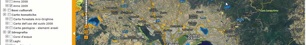
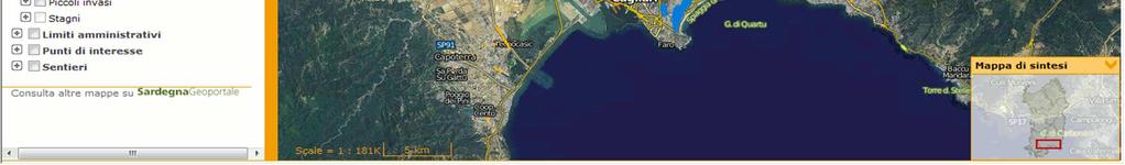
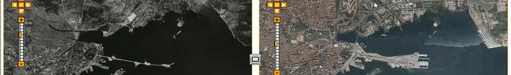
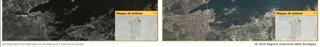
5 Sardinia Region geoportal 5


6 Network Services: discovery 6

7 Network Services: discovery 7
8 Network Services: discovery 8

9 Network Services: view 9

10 Network Services: view 10
11 Network Services: OGC-WMS 11


12 Network Services: download 12


13 Network Services: download 13

14 Network Services: download 14


15 Network Services: Transformation 15
16 Sardinia Region metadata - INSPIRE profile - ISO and ISO for data and services - ISO for Feature Catalogue 16
17 Europe 2020 Strategy: Digital Agenda goals Europe 2020 Strategy main aim: to exit the recent economic crisis The Smart Growth priority: economy based on technology and innovation The initiative Digital Agenda for Europe : - Interoperability and standards: data and services; - Opening up access to content: public sector information available on transparent, effective, non-discriminatory terms as economic resource - Review of the directive for PSI reuse (2003/98/EC) - Transparent licensing terms and conditions 17
18 SITR-IDT added value: open data Interoperability in SITR-IDT: - INSPIRE network services; - Metadata; - Clear and largely open licensing for data access and use 18
19 SITR-IDT open data licensing Every user can: - freely access, use, reproduce, distribute and modify data, also for commercial purposes; - freely use, reproduce and distribute derived data, also for commercial purposes; - a fee can be required only for dataelaborations: data direct resell is not allowed; - the Region of Sardinia must be always quoted as original data creator; - the same open conditions must be applied to all original and derived data Same principles of a GNU-GPL license: virality of open conditions Similar to an ODbL license 19
20 Benefits of an open and interoperable SDI Geographic data stand at the basis of a widespread amount of fields: tourism, transports, commerce,. Opening data with interoperable web services, standard formats and open data licenses offers a great potential to citizens, companies and professionals for their productive activities The economical benefit deriving from Sardinia SDI has not been estimated yet but the several accesses recorded are a good indication of the value of the offered services. 20
21 Issues to face Scarce knowledge of the SITR-IDT services and of what is nowadays available, mostly by the larger local municipalities and regional offices Sometimes a surprising knowledge of the SDI by small professionals or citizens Conclusive question: maybe the need of having spatial data and services in a scarce economic capability makes users more interested and more willing to use the existing services, with consequent possibility for the regional PA of improving them and optimizing the investment. 21
22 Thank you for your attention! 22

23
Implementation of INSPIRE Principles: Sardinia Region SDI State of the Art and Further Developments
 REGION OF SARDINIA (ITALY) LOCAL AUTHORITY FOR MUNICIPALITIES, FINANCES AND URBAN PLANNING DEPT. FOR THE REGIONAL SPATIAL DATA INFRASTRUCTURE Implementation of INSPIRE Principles: Sardinia Region SDI State
SITR-IDT The Spatial Data Infrastructure of Sardinia Region
 ITALY LOCAL AUTHORITY FOR MUNICIPALITIES, FINANCES AND URBAN PLANNING REGIONAL DEPARTMENT FOR CARTOGRAPHY AND INFORMATION SYSTEMS SITR-IDT The Spatial Data Infrastructure of Sardinia Region Content of
Zagreb Spatial Data Infrastructure. Sanja Batić, APIS IT Split, 14. rujna 2011.
 Zagreb Spatial Data Infrastructure Sanja Batić, APIS IT Split, 14. rujna 2011. Agenda Zagreb Spatial Data Infrastructure - ZIPP Guidelines for further ZIPP Geoportal development Conclusion 1964 The Centre
IDEBarcelona: Cooperating for a Smart Region Infrastructure
 IDEBarcelona: Cooperating for a Smart Region Infrastructure Marta Codinachs Serra Diputació de Barcelona Territory and Sustainability Area Territorial Information Systems Department SMART CITY EXPO WORLD
gvsig: Open Source Solutions in spatial technologies
 gvsig: Open Source Solutions in spatial technologies gvsig is a tool for handling geographical information, a completely GIS client with license GNU GPL. Alvaro A. Anguix Alfaro, Gabriel Carrión Rico Conselleria
The Process of Spatial Data Harmonization in Italy. Geom. Paola Ronzino
 The Process of Spatial Data Harmonization in Italy Geom. Paola Ronzino ISSUES Geospatial Information in Europe: lack of data harmonization the lack of data duplication of data CHALLENGES Challenge of INSPIRE:
GIS Building Communities beyond National Borders (Building Successful Spatial Data Infrastructures) Nick Land, ESRI Europe
 Nick Land, ESRI Europe") GIS Building Communities beyond National Borders (Building Successful Spatial Data Infrastructures) Nick Land, ESRI Europe UK worst flooding in the last 60 years 350,000 households without drinking water
GIS Building Communities beyond National Borders (Building Successful Spatial Data Infrastructures) Nick Land, ESRI Europe UK worst flooding in the last 60 years 350,000 households without drinking water
INSPIRE - A Legal framework for environmental and land administration data in Europe
 INSPIRE - A Legal framework for environmental and land administration data in Europe Dr. Markus Seifert Bavarian Administration for Surveying and Cadastre Head of the SDI Office Bavaria Delegate of Germany
Status of implementation of the INSPIRE Directive 2016 Country Fiches. COUNTRY FICHE Finland
 Status of implementation of the INSPIRE Directive 2016 Country Fiches COUNTRY FICHE Finland Introduction... 1 1. State of Play... 2 1.1 Coordination... 2 1.2 Functioning and coordination of the infrastructure...
The impacts of Open Government initiatives on SDIs
 The impacts of Open Government initiatives on SDIs Martin Seiler Coordination Office SDI Germany INSPIRE Conference 2013 Florence, 27 June 2013 Outline (Open) Government in Germany GDI-DE-architecture
Horizontal Interoperability among National Geoportals of ES, FR, PT & AD
 Horizontal Interoperability among National Geoportals of ES, FR, PT & AD A. F. Rodríguez S. Mas, D. Richard, J. M. Nataf, D. Furtado, R. P. Julião, S. Pijuan, S. Alba 1 Next 15 minutes Intoduction 4 National
ArcGIS for INSPIRE. Marten Hogeweg
 ArcGIS for INSPIRE Marten Hogeweg Please Take Our Survey on the App Download the Esri Events app and find your event Select the session you attended Scroll down to find the feedback section Complete answers
Sustainable and Harmonised Development for Smart Cities The Role of Geospatial Reference Data. Peter Creuzer
 Sustainable and Harmonised Development for Smart Cities The Role of Geospatial Reference Data Peter Creuzer 1. Introduction - Smart Cities and Geodata 2. Geodata in Germany 3. Examples 4. Data and Service
Land Use in the context of sustainable, smart and inclusive growth
 Land Use in the context of sustainable, smart and inclusive growth François Salgé Ministry of sustainable development France facilitator EUROGI vice president AFIGéO board member 1 Introduction e-content+
IRDAT Fvg, evolving a regional Spatial Data Infrastructure according to INSPIRE
 IRDAT Fvg, evolving a regional Spatial Data Infrastructure according to INSPIRE Tutti i diritti riservati. Proprietà INSIEL SpA. A. Benvenuti, A. Chiarandini Insiel (Italy) M. Lunardis - Friuli Venezia
Global Geospatial Information Management Country Report Finland. Submitted by Director General Jarmo Ratia, National Land Survey
 Global Geospatial Information Management Country Report Finland Submitted by Director General Jarmo Ratia, National Land Survey Global Geospatial Information Management Country Report Finland Background
INSPIRE Shared Service
 INSPIRE Shared Service Creation and operation out of the box Petra Fritz (HZD), Michael Voigtländer (Esri Deutschland GmbH) INSPIRE Shared Service Agenda HZD backbone for a geodata infrastructure Implementing
Emerging Trends in Institutional Arrangements Europe - Finland
 Emerging Trends in Institutional Arrangements Europe - Finland Arvo Kokkonen Deputy Director General National Land Survey of Finland 1 Contents Facts about Finland National Land Survey of Finland European
SITMUN: Cooperating to Build Local SDIs in the Barcelona Region
 SITMUN: Cooperating to Build Local SDIs in the Barcelona Region Diputació de Barcelona Territory and Sustainability Area Territorial Information Systems Department INSPIRE CONFERENCE Barcelona, September
Status of implementation of the INSPIRE Directive 2016 Country Fiches. COUNTRY FICHE Spain
 Status of implementation of the INSPIRE Directive 2016 Country Fiches COUNTRY FICHE Spain Introduction... 1 1. State of Play... 2 1.1 Coordination... 2 1.2 Functioning and coordination of the infrastructure...
Evaluating e-government : implementing GIS services in Municipality
 Evaluating e-government : implementing GIS services in Municipality Municipality of Thessaloniki - G.I.S. Unit Misirloglou Symeon Head of the GIS Unit ESRI UC - 2016 The GIS Section - subset of the department
NAG-City Expert Workshop Oslo 8-9. October 2012 SOSI standards and mapping for Europe (INSPIRE)
") NAG-City Expert Workshop Oslo 8-9. October 2012 SOSI standards and mapping for Europe (INSPIRE) Per Ryghaug, Geomatics The Norwegian national standard on geographic information - SOSI Started in 1984 NGU
NAG-City Expert Workshop Oslo 8-9. October 2012 SOSI standards and mapping for Europe (INSPIRE) Per Ryghaug, Geomatics The Norwegian national standard on geographic information - SOSI Started in 1984 NGU
SWEDISH SDI DEVELOPMENT & IMPLEMENTATION OF INSPIRE
 SWEDISH SDI DEVELOPMENT & IMPLEMENTATION OF INSPIRE Christina Wasström, Lantmäteriet, 801 82 Gävle, Sweden, christina.wasstrom@lm.se ABSTRACT The Swedish Government and Parliament has given Lantmäteriet
INSPIRE Basics. Vlado Cetl European Commission Joint Research Centre. https://ec.europa.eu/jrc/
 INSPIRE Basics Vlado Cetl European Commission Joint Research Centre https://ec.europa.eu/jrc/ Serving society Stimulating innovation Supporting legislation Outline SDI? Why European SDI? INSPIRE Policy
Report on the impact of open geographical data - Danish effect studies -
 Presented at the FIG Congress 2018, May 6-11, 2018 in Istanbul, Turkey Report on the impact of open geographical data - Danish effect studies - (Paper no 9603) Agenda 1. Intro teaser 2. Basic digital infrastructure
Ministry of ICT of I.R.IRAN
 The ECO 8/6 mill km 2 10 Slamic countries ~330 mill people Oil, Gas, Industries,Tourism 2 Issue transformation in last decade Problem solving needs more integrated approach More interaction &complexity
NATIONAL BENEFITS OF INSPIRE IMPLEMENTATION THE REAL LIFE USE CASES
 NATIONAL BENEFITS OF INSPIRE IMPLEMENTATION THE REAL LIFE USE CASES Andrius Balciunas, SE GIS Centras, a.balciunas@gis centras.lt Evaldas Rozanskas, SE GIS Centras, e.rozanskas@gis centras.lt INSPIRE conference
Status of implementation of the INSPIRE Directive 2016 Country Fiches. COUNTRY FICHE Portugal
 Status of implementation of the INSPIRE Directive 2016 Country Fiches COUNTRY FICHE Portugal Introduction... 1 1. State of Play... 2 1.1 Coordination... 2 1.2 Functioning and coordination of the infrastructure...
The Swedish National Geodata Strategy and the Geodata Project
 The Swedish National Geodata Strategy and the Geodata Project Ewa Rannestig, Head of NSDI Co-ordination Unit, Lantmäteriet, ewa.rannstig@lm.se Ulf Sandgren, Project Manager Geodata Project, Lantmäteriet,
INSPIREd solutions for Air Quality problems Alexander Kotsev
 INSPIREd solutions for Air Quality problems Alexander Kotsev www.jrc.ec.europa.eu Serving society Stimulating innovation Supporting legislation The European data puzzle The European data puzzle 24 official
INSPIRing Geospatial Framework For Local Administrations
 This project is financed by the European Union and the Republic of Turkey Presented at the FIG Congress 2018, May 6-11, 2018 in Istanbul, Turkey National Programme for Turkey 2010 Instrument for Pre-Accession
Maanmittauspäivät 2018 Helsinki Maanmittauspäivät 2018 The Danish initiatives regarding open and free basic data including effect studies
 Maanmittauspäivät 2018 The Danish initiatives regarding open and free basic data including effect studies 22.03.2018 Agenda 1. Intro overall frame / selfie 2. Data Infrastructure 3. The Danish Digital
Governance and performance of open spatial data policies in the context of INSPIRE
 Governance and performance of open spatial data policies in the context of INSPIRE Dr. Glenn Vancauwenberghe Delft University of Technology Dr. ir. Bastiaan van Loenen Delft University of Technology 1
Henning Sten Hansen, Line Hvingel & Lise Schrøder (AAU) Jesper Høi Skovdal (Geoforum Denmark) LISE SCHRØDER AALBORG UNIVERSITY
 Jesper Høi Skovdal (Geoforum Denmark) LISE SCHRØDER AALBORG UNIVERSITY") Henning Sten Hansen, Line Hvingel & Lise Schrøder (AAU) Jesper Høi Skovdal (Geoforum Denmark) Presentation overview Background Nordic surveys The way forward Concluding remarks Transforming government
Henning Sten Hansen, Line Hvingel & Lise Schrøder (AAU) Jesper Høi Skovdal (Geoforum Denmark) Presentation overview Background Nordic surveys The way forward Concluding remarks Transforming government
EuroGeographics & INSPIRE. Nick Land, Executive Director of EuroGeographics
 EuroGeographics & INSPIRE Nick Land, Executive Director of EuroGeographics EuroGeographics A growing association 49 Members, 42 countries Topographic mapping, cadastre, land registry + Networked organisation
Status of implementation of the INSPIRE Directive 2016 Country Fiches. COUNTRY FICHE Italy
 Status of implementation of the INSPIRE Directive 2016 Country Fiches COUNTRY FICHE Italy Introduction... 1 1. State of Play... 2 1.1 Coordination... 2 1.2 Functioning and coordination of the infrastructure...
Implementing strategy for the Infrastructure for Spatial Information in Europe - INSPIRE Paul Smits
 Implementing strategy for the Infrastructure for Spatial Information in Europe - INSPIRE Paul Smits European Commission DG Joint Research Centre Institute for Environment and Sustainability Ispra, Italy
Turkey s National SDI Implementation
 Onur PAŞAOĞULLARI Head of Department Turkey s National SDI Implementation Presentation Plan NSDI Background General Directorate of Geographic Information Systems NSDI Project INSPIRE Directive Urban Information
INSPIRE Monitoring and Reporting Implementing Rule Draft v2.1
 INSPIRE Infrastructure for Spatial Information in Europe INSPIRE Monitoring and Reporting Implementing Rule Draft v2.1 Title INSPIRE Monitoring and Reporting Implementing Rule v2.1 Creator DT Monitoring
Spatially Enabled Society
 International Seminar on Land Administration Trends and Issues in Asia and the Pacific Region Spatially Enabled Society Abbas Rajabifard Vice Chair PCGIAP-WG3 Vice-President (President Elect), GSDI Association
E-Government and SDI in Bavaria, Germany
 135 E-Government and SDI in Bavaria, Germany Wolfgang STOESSEL, Germany Key words: GDI-BY, Bavaria, Spatial Data Infrastructure SUMMARY Spatial Data Infrastructure (SDI) is an important part of the e-government
Roadmap to interoperability of geoinformation
 Roadmap to interoperability of geoinformation and services in Europe Paul Smits, Alessandro Annoni European Commission Joint Research Centre Institute for Environment and Sustainability paul.smits@jrc.it
How local communities could profit from Habitats infrastructure
 Social Validation of INSPIRE Annex III Data Structures in EU Habitats How local communities could profit from Habitats infrastructure Andrea Scianna ( Icar CNR Italy ) consultant for Madonie Park Authority
Key Points Sharing fosters participation and collaboration Metadata has a big role in sharing Sharing is not always easy
 Sharing Resources Geoff Mortson esri, Inc. SDI Solutions Team Key Points Sharing fosters participation and collaboration Metadata has a big role in sharing Sharing is not always easy Data Sharing is Good
ISO Series Standards in a Model Driven Architecture for Landmanagement. Jürgen Ebbinghaus, AED-SICAD
 ISO 19100 Series Standards in a Model Driven Architecture for Landmanagement Jürgen Ebbinghaus, AED-SICAD 29.10.2003 The Company 100% SIEMENS PTD SIEMENS Business Services Shareholder & Strategic Business
Spatial information for urban planning and management case study Zagreb Darko ŠIŠKO, Vlado CETL, Tomislav CICELI. Strasbourg, September 7th, 2017
 Spatial information for urban planning and management case study Zagreb Darko ŠIŠKO, Vlado CETL, Tomislav CICELI Strasbourg, September 7th, 2017 Contents: Cities & INSPIRE Cities in Croatian NSDI City
INSPIRE in Sweden - an Important Part of the National Geodata Strategy
 INSPIRE in Sweden - an Important Part of the National Geodata Strategy Ewa RANNESTIG and Monica LAGERQVIST NILSSON, Sweden Key words: National Geodata Strategy, National Infrastructure for Spatial Information,
SDI Implementation at the Local
 SDI Implementation at the Local Administration Level of Germany Hartmut Müller and Stephan von St. Vith FIG Working Week 2009 Surveyors Key Role in Accelerated Development, Eilat, Israel, 3-8 May 2009
Tomas Mildorf New technologies for the information society University of west bohemia in pilsen, Czech republic
 Tomas Mildorf New technologies for the information society University of west bohemia in pilsen, Czech republic Karel Charvat Help Service Remote Sensing, Czech republic AIP-7 GEOSS, 20 MAY 2014 By 2015,
Benefits Realised from INSPIRE:
 Benefits Realised from INSPIRE: Max Craglia European Commission Joint Research Centre www.jrc.ec.europa.eu Serving society Stimulating innovation Supporting legislation Background to INSPIRE Europe is
The state-of-the-art of the Finnish SDI. Arctic SDI WG Meeting
 The state-of-the-art of the Finnish SDI Arctic SDI WG Meeting Moscow 8.9.2011 Esa Tiainen Development Centre 1 NATIONAL LAND SURVEY DOWN TO EARTH Contents Legal framework Coordination structure Network
SDI-Challenges European perspective
 THE HIGH LEVEL FORUM ON GLOBAL GEOSPATIAL INFORMATION MANAGEMENT Seoul, Republic of Korea, 24-26 October 2011 Session 1: Challenges in geospatial policy formation and institutional arrangements SDI-Challenges
GRISI: Geomatic Regional Information Society Initiative M. Cabello 1, A. Valentín 2. 2
 GRISI: Geomatic Regional Information Society Initiative M. Cabello 1, A. Valentín 2 1 Trabajos Catastrales, S.A., Pamplona, Spain mcabello@tracasa.es 2 Government of Navarra, SITNA Secretary, Pamplona,
a national geological survey perspective François ROBIDA BRGM (French Geological Survey)
") a national geological survey perspective François ROBIDA BRGM (French Geological Survey) Pre-Conference Seminar on Socio-Economic Value of Geospatial for National and Regional Development 21 August 2017,
a national geological survey perspective François ROBIDA BRGM (French Geological Survey) Pre-Conference Seminar on Socio-Economic Value of Geospatial for National and Regional Development 21 August 2017,
Quality information for the Digital Agenda EuroGeographics contribution to the Digital Agenda for Europe
 Quality information for the Digital Agenda EuroGeographics contribution to the Digital Agenda for Europe Ingrid Vanden Berghe, EuroGeographics President high performance infrastructure quality contentinformation
Demonstration of a local SDI solution with several stakeholders in pilot areas in line with EU best practices
 EU Twinning project for the Agency of Land Relations and Cadaster (ALRC)- Organization, Streamlining and Computerization Process in Mapping in the Republic of Moldova. Demonstration of a local SDI solution
Land Board, NW Services and SDI Tambet Tiits, FRICS
 Land Board, NW Services and SDI Tambet Tiits, FRICS 07.09.2016 200th anniversary of the Struve Geodetic Arc Friedrich Georg Wilhelm Struve and Carl Friedrich Tenner Struve Geodetic Arc The Struve Geodetic
Norwegian spatial data infrastructure supporting disaster risk management Norwegian Mapping Authority
 Norwegian spatial data infrastructure supporting disaster risk management Norwegian Mapping Authority Arvid Lillethun, Norwegian Mapping Authority Land and Poverty 2018 Conference, World Bank 19.-23. March
Status of implementation of the INSPIRE Directive 2016 Country Fiches. COUNTRY FICHE Malta
 Status of implementation of the INSPIRE Directive 2016 Country Fiches COUNTRY FICHE Malta Introduction... 1 1. State of Play... 2 1.1 Coordination... 2 1.2 Functioning and coordination of the infrastructure...
INSPIRE implementation in the Turkish Ministry of Environment and Urbanization Producing and Publishing Environmental Data
 INSPIRE implementation in the Turkish Ministry of Environment and Urbanization Producing and Publishing Environmental Data Ezgi Sarmusak Urban Planner, MoEU Sibel Süer Toybıyık - Assistant Expert, MoEU
Analys av GIS-användning inom offentlig sektor i Norden
 Analys av GIS-användning inom offentlig sektor i Norden Henning Sten Hansen, Line Hvingel and Lise Schrøder Aalborg Universitet Jönköping, Sweden 30 March 2011 Overview The Danish and Swedish approaches
Status of implementation of the INSPIRE Directive 2016 Country Fiches. COUNTRY FICHE France
 Status of implementation of the INSPIRE Directive 2016 Country Fiches COUNTRY FICHE France Introduction... 1 1. State of Play... 2 1.1 Coordination... 2 1.2 Functioning and coordination of the infrastructure...
Implementation of Inspire in Denmark - How we get it flying! Olav Eggers National Survey & Cadastre -Denmark
 Implementation of Inspire in Denmark - How we get it flying! Olav Eggers oe@kms.dk National Survey & Cadastre -Denmark Introduction Overview Infrastructure for Spatial Information Act National Survey and
Oman NSDI Supporting Economic Development. Saud Al-Nofli Director of Spatial Data Directorate General of NSDI, NCSI
 Oman NSDI Supporting Economic Development 2017 Saud Al-Nofli Director of Spatial Data Directorate General of NSDI, NCSI "It s critical to make correct decisions the first time to optimize the Investments
Gistat: moving towards a location information management system
 Gistat: moving towards a location information management system (merging geographical, statistical and historical information) Pina Grazia Ticca Marco Ballin Istat - Italy Aguascalientes, Mexico 2-4 December
Spatial Data Infrastructures in Greece: State of play Spring 2003
 Spatial Data Infrastructures in : State of play Spring 2003 Country report on SDI elaborated in the context of a study commissioned by the EC (EUROSTAT & DGENV) in the framework of the INSPIRE initiative
Open spatial data infrastructure
 Open spatial data infrastructure a backbone for digital government Thorben Hansen Geomatikkdagene 2018 Stavanger 13.-15. mars Spatial Data Infrastructure definition the technology, policies, standards,
Spatial data interoperability and INSPIRE compliance the platform approach BAGIS
 Spatial data interoperability and INSPIRE compliance the platform approach BAGIS BAGIS Voluntary, independent, public, non-profit organization; Organization with main mission to promote the growth of the
INSPIRE Directive. Status June 2007
 INSPIRE Directive INfrastructure for SPatial InfoRmation in Europe Status June 2007 European Commission Directorate-General Environment Research, Science and Innovation Unit Rue de la Loi, 200 1049 Brussels
Using OGC standards to improve the common
 Using OGC standards to improve the common operational picture Abstract A "Common Operational Picture", or a, is a single identical display of relevant operational information shared by many users. The
SDI in Lombardia (Italy(
 SDI in Lombardia (Italy( Italy) Andrea Piccin European SDI Best Practice Awards 2009 - Learning from Best Practices Turin, 26th and 27th November 2009 Lombardia, in Italy, is 4 th Region for territorial
NATIONAL SPATIAL DATA INFRASTRUCTURE OF SPAIN: ORGANISATIONAL & LEGAL FRAMEWORK.
 NATIONAL SPATIAL DATA INFRASTRUCTURE OF SPAIN: ORGANISATIONAL & LEGAL FRAMEWORK. ABSTRACT. Sebastian Mas-Mayoral Antonio F. Rodríguez-Pascual Instituto Geográfico Nacional (National Geographic Institute)
Status of implementation of the INSPIRE Directive 2016 Country Fiches. COUNTRY FICHE Denmark
 Status of implementation of the INSPIRE Directive 2016 Country Fiches COUNTRY FICHE Denmark Introduction... 1 1. State of Play... 2 1.1 Coordination... 2 1.2 Functioning and coordination of the infrastructure...
INSPIRE General Introduction & Service Architecture
 INSPIRATION Spatial Data Infrastructure in the Western Balkans INSPIRE General Introduction & Service Architecture 1st National INSPIRATION Workshop Croatia November 21-22, 2012 A multi-countryprojectfunded
ArcGIS for INSPIRE. Marten Hogeweg Satish Sankaran
 ArcGIS for INSPIRE Marten Hogeweg Satish Sankaran Outline What is ArcGIS ArcGIS for INSPIRE Web GIS Case Studies Roadmap Q&A What is INSPIRE? INSPIRE is the legal framework for a European Spatial Data
INSPIRATION results and benefits for the Agency for Real Estate Cadastre
 JOINT RESEARCH CENTER - E&I WORKSHOP INSPIRATION results and benefits for the Agency for Real Estate Cadastre Sonja Dimova, state advisor AGENCY FOR REAL ESTATE CADASTRE REPUBLIC OF MACEDONIA Wednesday,
INSPIRE and Land Use Planning System in Portugal
 INSPIRE and Land Use Planning System in Portugal Rui Amaro Alves Director General Directorate General for Territorial Development ruialves@dgterritorio.pt Carlos Simões Senior Technician Directorate General
Status of implementation of the INSPIRE Directive 2016 Country Fiches. COUNTRY FICHE Czech Republic
 Status of implementation of the INSPIRE Directive 2016 Country Fiches COUNTRY FICHE Czech Republic Introduction... 1 1. State of Play... 2 1.1 Coordination... 2 1.2 Functioning and coordination of the
EXPECTATIONS OF TURKISH ENVIRONMENTAL SECTOR FROM INSPIRE
 EXPECTATIONS OF TURKISH ENVIRONMENTAL SECTOR FROM INSPIRE June, 2010 Ahmet ÇİVİ Tuncay DEMİR INSPIRE in the Eyes of MoEF Handling of Geodata by MoEF Benefits Expected TEIEN First Steps for INSPIRE Final
Building a national spatial data infrastructure. Thorben Hansen, Head of Division Danish Agency for Data Supply and Efficiency
 Building a national spatial data infrastructure Thorben Hansen, Head of Division Danish Agency for Data Supply and Efficiency About Spatial Data Infrastructure Spatial data come from many sources and is
Implementing INSPIRE Geoportal in Turkey
 Implementing INSPIRE Geoportal in Turkey Gencay SERTER City and Regional Planner 1 Presentation Plan Introduction INSPIRE and Turkey Importance of al Spatial Planning Portal Logical&Legal Hierarchy GeoPortal
Plan4all (econtentplus project)
") Plan4all (econtentplus project) Karel CHARVAT 1, Tomáš MILDORF 2 1 Help service remote sensing, Ltd., Černoleská 1600, 256 01 Benešov u Prahy, Czech Republic charvat@bnhelp.cz 2 Department of Mathematics
Plan4all (econtentplus project) Karel CHARVAT 1, Tomáš MILDORF 2 1 Help service remote sensing, Ltd., Černoleská 1600, 256 01 Benešov u Prahy, Czech Republic charvat@bnhelp.cz 2 Department of Mathematics
Infrastructure for Spatial Information in Europe (INSPIRE)
") Infrastructure for Spatial Information in Europe (INSPIRE) 2011 GISCO Working Party 8-9.3.2012 INSPIRE is about improving access to spatial information: the environment doesn t stop at borders EU Geoportal
Infrastructure for Spatial Information in Europe (INSPIRE) 2011 GISCO Working Party 8-9.3.2012 INSPIRE is about improving access to spatial information: the environment doesn t stop at borders EU Geoportal
ArcGIS for INSPIRE. Paul Hardy. ArcGIS. ArcGIS for INSPIRE Enables Esri ArcGIS users to implement and comply with INSPIRE. INSPIRE Data Themes
 Enables Esri ArcGIS users to implement and comply with INSPIRE Paul Hardy phardy@esri.com EuroGeographics INSPIRE KEN (Schema Transformation) 8/9 October 2013, Marne la Vallée INSPIRE Data Themes Annex
INSPIRE and egovernment policies: a common governance for a wider public sector information infrastructure
 INSPIRE and egovernment policies: a common governance for a wider public sector information infrastructure Gabriele Ciasullo Leonardo Donnaloia Antonio Rotundo 2 EU needs and actions Reference document
Overview of Geospatial Open Source Software which is Robust, Feature Rich and Standards Compliant
 Overview of Geospatial Open Source Software which is Robust, Feature Rich and Standards Compliant Cameron SHORTER, Australia Key words: Open Source Geospatial Foundation, OSGeo, Open Standards, Open Geospatial
Proposal for a DIRECTIVE OF THE EUROPEAN PARLIAMENT AND OF THE COUNCIL. establishing an infrastructure for spatial information in the Community
 Proposal for a DIRECTIVE OF THE EUROPEAN PARLIAMENT AND OF THE COUNCIL establishing an infrastructure for spatial information in the Community INSPIRE http://inspire.jrc.it/ Alessandro Annoni 1 EU Commission
STATE GEOGRAPHIC INFORMATION DATABASE
 STATE GEOGRAPHIC INFORMATION DATABASE Data Information and Knowledge Management STATE GEOGRAPHIC INFORMATION DATABASE EXECUTIVE SUMMARY Utah has developed one of the most comprehensive statewide GIS resources
Open Data meets Big Data
 Open Data meets Big Data Max Craglia, Sven Schade, Anders Friis European Commission Joint Research Centre www.jrc.ec.europa.eu Serving society Stimulating innovation Supporting legislation JRC is Technical
INSPIRing effort. Peter Parslow Ordnance Survey December Various European approaches to managing an SDI
 INSPIRing effort Peter Parslow Ordnance Survey December 2015 Various European approaches to managing an SDI WHAT IS INSPIRE? A European Union Directive A community effort: http://inspire.ec.europa.eu/
UNOFFICIAL TRANSLATION
 UNOFFICIAL TRANSLATION THE CROATIAN PARLIAMENT 1135 Pursuant to Article 89 of the Constitution of the Republic of Croatia, I hereby issue the DECISION PROMULGATING THE NATIONAL SPATIAL DATA INFRASTRUCTURE
Regione Umbria. ESRI EMEA User Conference 2010 Rome, October 27th 2010
 Direzione Ambiente, Territorio e Infrastrutture Servizio Informatico/Informativo: geografico, ambientale e territoriale ESRI EMEA User Conference 2010 Rome, October 27th 2010 Arch. Ambra Ciarapica, Dott.
REGION AND STATES INTERCONNEXIONS : CRIGE PACA, SWISSTOPO AND FRENCH PORTALS. Dr. C. Giger (swisstopo) S. Maffren (CRIGE PACA) D.
 S. Maffren (CRIGE PACA) D.") REGION AND STATES INTERCONNEXIONS : CRIGE PACA, SWISSTOPO AND FRENCH PORTALS Dr. C. Giger (swisstopo) S. Maffren (CRIGE PACA) D. Richard (IGN) Components to connect PACA portal French Geoportal Local datasets
REGION AND STATES INTERCONNEXIONS : CRIGE PACA, SWISSTOPO AND FRENCH PORTALS Dr. C. Giger (swisstopo) S. Maffren (CRIGE PACA) D. Richard (IGN) Components to connect PACA portal French Geoportal Local datasets
Status of implementation of the INSPIRE Directive 2016 Country Fiches. COUNTRY FICHE Croatia
 Status of implementation of the INSPIRE Directive 2016 Country Fiches COUNTRY FICHE Croatia Introduction... 1 1. State of Play... 2 1.1 Coordination... 2 1.2 Functioning and coordination of the infrastructure...
Status of implementation of the INSPIRE Directive 2016 Country Fiches. COUNTRY FICHE Estonia
 Status of implementation of the INSPIRE Directive 2016 Country Fiches COUNTRY FICHE Estonia Introduction... 1 1. State of Play... 2 1.1 Coordination... 2 1.2 Functioning and coordination of the infrastructure...
Status of implementation of the INSPIRE Directive 2016 Country Fiches. COUNTRY FICHE Netherlands
 Status of implementation of the INSPIRE Directive 2016 Country Fiches COUNTRY FICHE Netherlands Introduction... 1 1. State of Play... 2 1.1 Coordination... 2 1.2 Functioning and coordination of the infrastructure...
Status of implementation of the INSPIRE Directive 2016 Country Fiches. COUNTRY FICHE Ireland
 Status of implementation of the INSPIRE Directive 2016 Country Fiches COUNTRY FICHE Ireland Introduction... 1 1. State of Play... 2 1.1 Coordination... 2 1.2 Functioning and coordination of the infrastructure...
SDI in Finland Nordic SDI Seminar Uppsala Panu Muhli
 SDI in Finland Nordic SDI Seminar Uppsala 3.10.2011 Panu Muhli Spatial Data Infrastructure Team Inspire secretariat Development Centre 1 NATIONAL LAND SURVEY DOWN TO EARTH Contents Legal framework Coordination
Innovation in Land Management: Integrated Solutions For National Cadastre Projects
 Success With GIS Innovation in Land Management: Integrated Solutions For National Cadastre Projects XXIII International FIG Congress Munich These documents are only complete, when used in connection with
An analysis of Agile conferences papers: a snapshot of the GI&GIS research in Europe
 An analysis of Agile conferences papers: a snapshot of the GI&GIS research in Europe Pasquale Di Donato, Mauro Salvemini University of Rome La Sapienza Piazza Borghese 9 00186 Roma, Italy pasquale.didonato@uniroma1.it,