SCENT: A Smart Toolbox for Engaging Citizens into a People Centric Observation Web. INSPIRE 2016 Conference Barcelona, 28 September 2016
|
|
|
- Logan Harmon
- 5 years ago
- Views:
Transcription
1 SCENT: A Smart Toolbox for Engaging Citizens into a People Centric Observation Web INSPIRE 2016 Conference Barcelona, 28 September 2016
2 Summary SCENT Facts & figures Motivation a glance SCENT objectives SCENT architecture Large scale demonstrations Dissemination channels Target markets 2


3 SCENT facts & figures H2020 Call: SC Demonstrating the concept of Citizen Observatories EC requested funding 3,264,675 Duration 09/ / Large scale demos 3 Research institutes 1 Large industry 3 SMEs 3 NGOs / public bodies 3


![Pluvial flooding in Coibra, [Source: Imperial College] Flooding](/docs-images/95/126058588/images/4-4.jpg "in Chennai, [Source: Oxford Analytica] Flooding in Vietnam,")
4 Motivation Flooding is a major environmental issue related to land cover/use urban development, critical infrastructure, soil fertility Assets close to flood plains driver for economic development societal risk in case of flood loss potential Pluvial flooding in Coibra, [Source: Imperial College] Flooding in Chennai, [Source: Oxford Analytica] Flooding in Vietnam, [Source: Floodlist] 4


5 Land cover/use influences flooding Large scale diversions, earthworks Flood embankments Urbanisation, changing natural surfaces to artificial areas [Source: Noah systems] Agricultural practices related to choice of crop, cropping pattern & soil drainage system Forestation: density of forest, canopy, soil cover Land use malpractices, e.g. excessive logging, conversion of forested areas into other land use types, conversion of land through forest fires. [Source: Telegraph] 5

6 6 a glance
7 SCENT objectives People centric Observation Web Develop OGC compliant web services and resources for GEOSS portal SCENT crowd sourcing platform Collect image & text from citizens, thus extend the in situ infrastructure with citizensourced observations SCENT intelligence engine Implement innovative machine learning to classify & annotate images/text sourced from citizens & existing open platforms. Serious gaming applications Annotate unutilised images from popular platforms, e.g. Flickr, Panoramio 7
8 SCENT objectives (2) Quantification of impact of land cover/use changes Improve flood risk maps and spatio temporal flooding patterns. Simple authoring tool for policy makers Customise SCENT toolbox according to target group, regional or social characteristics. Testing & validation of the SCENT smart toolbox Run 2 large scale pilots of great environmental impact; the urban case of Kifisos river in Attica and the rural case of Danube Delta. Increase active engagement of citizens, associations, local authorities Create a sustainable citizen movement 8
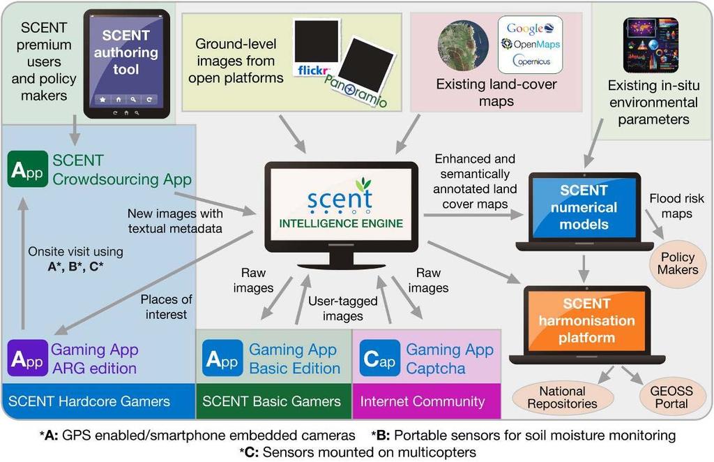
9 9 SCENT architecture


10 SCENT Large scale demos Urban demo: Kifisos river catchment in Attica, Greece Rural demo: Danube Delta in Tulcea, Romania 10

11 SCENT Large scale demos (2) At least 200 participants in each demo, aiming to reach ~ 1000 SCENT NGOs (HRTA, SOR) 5 municipalities around Kifisos mobilised by Attica regional authority External volunteer groups & environmental associations Individual citizens mobilised through SCENT dissemination campaigns Danube Delta Online SCENT toolbox validation Download gaming app in personal devices for image annotation from Flickr, Panoramio Use CAPTCHA plugin and implicitly annotate pool of images from open repositories 11


12 SCENT Target markets Municipalities, regional governments, ministries of environment Website developers Open & commercial map providers Photo sharing platforms Social network providers Civil protection agencies, NGOs Education ministries, schools 12


13 SCENT Dissemination channels Networking with environmental associations, grassroot orgs & NGOs Training Dissemination material, website, social media Publications, Conferences SCENT Brand identity Early childhood education programmes TV documentary Links with other Citizen Observatories 13
14 Athanasia Tsertou, Team Leader, Smart Integrated Systems, I SENSE Group, ICCS 14 This work is a part of the SCENT project. This project has received funding from the European Union s Horizon 2020 research and innovation programme under grant agreement no
EuroGEOSS Protected Areas Pilot
 EuroGEOSS Protected Areas Pilot Max Craglia European Commission Joint Research Centre Part 1: the present MyNatura2000 Mobile app. Awareness raising & volunteered data collection. Natura2000 covers 18%
COUNCIL OF THE EUROPEAN UNION. Brussels, 2 May /14 CULT 68
 COUNCIL OF THE EUROPEAN UNION Brussels, 2 May 2014 9129/14 CULT 68 NOTE from: General Secretariat of the Council to: Permanent Representatives Committee (Part 1) / Council No. prev. doc.: 8892/14 CULT
Open spatial data infrastructure
 Open spatial data infrastructure a backbone for digital government Thorben Hansen Geomatikkdagene 2018 Stavanger 13.-15. mars Spatial Data Infrastructure definition the technology, policies, standards,
Plan4all (econtentplus project)
") Plan4all (econtentplus project) Karel CHARVAT 1, Tomáš MILDORF 2 1 Help service remote sensing, Ltd., Černoleská 1600, 256 01 Benešov u Prahy, Czech Republic charvat@bnhelp.cz 2 Department of Mathematics
Plan4all (econtentplus project) Karel CHARVAT 1, Tomáš MILDORF 2 1 Help service remote sensing, Ltd., Černoleská 1600, 256 01 Benešov u Prahy, Czech Republic charvat@bnhelp.cz 2 Department of Mathematics
Urban Climate Resilience
 Urban Climate Resilience in Southeast Asia Partnership Project Introduction Planning for climate change is a daunting challenge for governments in the Mekong Region. Limited capacity at the municipal level,
Manual of Digital Earth
 V8.0 March 27, 2018 International Society for Digital Earth Manual of Digital Earth (Tentative Title) OUTLINE Foreword Chapter 1 Understanding Digital Earth 1.1 Origins and Precursors of Digital Earth
Copernicus Data Driven Services for Regional & Local Government in Greece
 Workshop on Copernicus uptake by public authorities Gabriel Mavrellis CEO, Geospatial Enabling Technologies Copernicus Data Driven Services for Regional & Local Government in Greece The Company Copernicus
Earth Observation and GEOSS in Horizon Copernicus for Raw Material Workshop 5 th September 2016
 Earth Observation and GEOSS in Horizon 2020 Copernicus for Raw Material Workshop 5 th September 2016 Gilles OLLIER Head of Sector -Earth observation Directorate Environment Unit I.4 Climate Actions and
16540/14 EE/cm 1 DG E 1A
 Council of the European Union Brussels, 5 December 2014 (OR. en) 16540/14 ENV 965 CULT 139 NOTE From: To: Subject: General Secretariat of the Council Delegations Charter of Rome on Natural and Cultural
WMO Guide on Integrated Urban Weather, Environment and Climate Services for Cities (IUWECS) Hong Kong- an experience from a high-density city
 Hong Kong- an experience from a high-density city") WMO Guide on Integrated Urban Weather, Environment and Climate Services for Cities (IUWECS) Hong Kong- an experience from a high-density city Dr. Chao REN Associate Professor School of Architecture The
WMO Guide on Integrated Urban Weather, Environment and Climate Services for Cities (IUWECS) Hong Kong- an experience from a high-density city Dr. Chao REN Associate Professor School of Architecture The
I&CLC2000 in support to new policy initiatives (INSPIRE, GMES,..)
") I&CLC2000 in support to new policy initiatives (INSPIRE, GMES,..) Manfred Grasserbauer, Director Joint Research Centre Institute for Environment and Sustainability 1 IMAGE 2000 European mosaic of satellite
I&CLC2000 in support to new policy initiatives (INSPIRE, GMES,..) Manfred Grasserbauer, Director Joint Research Centre Institute for Environment and Sustainability 1 IMAGE 2000 European mosaic of satellite
Tools to Assess Local Health Needs. Richard Leadbeater, Esri NACo 2011 Healthy Counties Forum December 1, 2011
 Tools to Assess Local Health Needs Richard Leadbeater, Esri NACo 2011 Healthy Counties Forum December 1, 2011 Richard Leadbeater currently holds the position of Industry Solutions Manager with Esri. He
Harmonizing spatial databases and services at local and regional level
 Harmonizing spatial databases and services at local and regional level A. Ionita 1, M. Caian 2, V. Vassilev 3, V. Craciunescu 2, I. Nedelcu 4 1 Research Institute for Artificial Intelligence, Bucuresti,
INSPIREd solutions for Air Quality problems Alexander Kotsev
 INSPIREd solutions for Air Quality problems Alexander Kotsev www.jrc.ec.europa.eu Serving society Stimulating innovation Supporting legislation The European data puzzle The European data puzzle 24 official
Roadmap to interoperability of geoinformation
 Roadmap to interoperability of geoinformation and services in Europe Paul Smits, Alessandro Annoni European Commission Joint Research Centre Institute for Environment and Sustainability paul.smits@jrc.it
Land Use in the context of sustainable, smart and inclusive growth
 Land Use in the context of sustainable, smart and inclusive growth François Salgé Ministry of sustainable development France facilitator EUROGI vice president AFIGéO board member 1 Introduction e-content+
Study on Data Integration and Sharing Standard and Specification System for Earth System Science
 Study on Data Integration and Sharing Standard and Specification System for Earth System Science Juanle Wang and Jiulin Sun Information Sharing Center for Earth System Science Institute of Geographic Sciences
Collaborative Systems for the Creation of Marine Services
 Collaborative Systems for the Creation of Marine Services INSPIRE 2016 Nuno Almeida Nuno Catarino Barcelona, 28 th September 2016 Elecnor Deimos is a trademark which encompasses Elecnor Group companies
ArcGIS for INSPIRE. Marten Hogeweg Satish Sankaran
 ArcGIS for INSPIRE Marten Hogeweg Satish Sankaran Outline What is ArcGIS ArcGIS for INSPIRE Web GIS Case Studies Roadmap Q&A What is INSPIRE? INSPIRE is the legal framework for a European Spatial Data
GIS Geographical Information Systems. GIS Management
 GIS Geographical Information Systems GIS Management Difficulties on establishing a GIS Funding GIS Determining Project Standards Data Gathering Map Development Recruiting GIS Professionals Educating Staff
The ESPON Programme. Goals Main Results Future
 The ESPON Programme Goals Main Results Future Structure 1. Goals Objectives and expectations Participation, organisation and networking Themes addressed in the applied research undertaken in ESPON projects
Oman NSDI Business Values and Future Directions. Hassan Alawi Alghazali Acting Director General National Spatial Data Infrastructure
 Oman NSDI Business Values and Future Directions Hassan Alawi Alghazali Acting Director General National Spatial Data Infrastructure Presentation Outline Geospatial Maturity Current Challenges NCSI s Role
Open Data meets Big Data
 Open Data meets Big Data Max Craglia, Sven Schade, Anders Friis European Commission Joint Research Centre www.jrc.ec.europa.eu Serving society Stimulating innovation Supporting legislation JRC is Technical
Tomas Mildorf New technologies for the information society University of west bohemia in pilsen, Czech republic
 Tomas Mildorf New technologies for the information society University of west bohemia in pilsen, Czech republic Karel Charvat Help Service Remote Sensing, Czech republic AIP-7 GEOSS, 20 MAY 2014 By 2015,
National Public Weather and Warning Services in the Swaziland Meteorological Service Dennis S.Mkhonta /
 National Public Weather and Warning Services in the Swaziland Meteorological Service Dennis S.Mkhonta dennis.mkhonta@gmail.com / dennis@swazimet.gov.sz Introduction Swaziland s geographical position exposes
Alps Results from the ESPON Project. Common spatial perspectives for the Alpine area. Towards a common vision
 Results from the ESPON Project Alps 2050 Common spatial perspectives for the Alpine area. Towards a common vision Tobias Chilla, University of Erlangen Cooperation Alps 2020+ 1 & 2 October 2018 Salzburg
IDEBarcelona: Cooperating for a Smart Region Infrastructure
 IDEBarcelona: Cooperating for a Smart Region Infrastructure Marta Codinachs Serra Diputació de Barcelona Territory and Sustainability Area Territorial Information Systems Department SMART CITY EXPO WORLD
Compact guides GISCO. Geographic information system of the Commission
 Compact guides GISCO Geographic information system of the Commission What is GISCO? GISCO, the Geographic Information System of the COmmission, is a permanent service of Eurostat that fulfils the requirements
Norwegian spatial data infrastructure supporting disaster risk management Norwegian Mapping Authority
 Norwegian spatial data infrastructure supporting disaster risk management Norwegian Mapping Authority Arvid Lillethun, Norwegian Mapping Authority Land and Poverty 2018 Conference, World Bank 19.-23. March
Geography for the 2020 Round of Census
 Boundaries Key Census Data EA Id Population Male Female EA Id Area EA Id Num HH Avg HH size Geography for the 2020 Round of Census Linda Peters, Esri lpeters@esri.com Integration of Statistical and Geospatial
Exploring GIS Potential for Northwestern Ontario Land Information Ontario
 Exploring GIS Potential for Northwestern Ontario Land Information Ontario May 13, 2015 The LIO Vision LIO Vision: That all geographic information about Ontario is fully integrated and accessible LIO Goal:
Key Points Sharing fosters participation and collaboration Metadata has a big role in sharing Sharing is not always easy
 Sharing Resources Geoff Mortson esri, Inc. SDI Solutions Team Key Points Sharing fosters participation and collaboration Metadata has a big role in sharing Sharing is not always easy Data Sharing is Good
Establishment of the Hellenic Ecosystem Services Partnership (HESP) research group: Drafting the national agenda for the implementation of the
 research group: Drafting the national agenda for the implementation of the") Establishment of the Hellenic Ecosystem Services Partnership (HESP) research group: Drafting the national agenda for the implementation of the ES concept in Greece Establishment of the Hellenic Ecosystem
Establishment of the Hellenic Ecosystem Services Partnership (HESP) research group: Drafting the national agenda for the implementation of the ES concept in Greece Establishment of the Hellenic Ecosystem
Declaration Population and culture
 Declaration Population and culture The ministers of the parties to the Alpine Convention regard the socio-economic and socio-cultural aspects mentioned in Article 2, Paragraph 2, Item a., as being central
GEO Geohazards Community of Practice
 GEO Geohazards Community of Practice 1) Co-Chair of GHCP With input from: Stuart Marsh, GHCP Co-Chair Francesco Gaetani, GEO Secretariat and many GHCP contributors 1) Nevada Bureau of Mines and Geology
Management Planning & Implementation of Communication Measures for Terrestrial Natura 2000 Sites in the Maltese Islands Epsilon-Adi Consortium
 Management Planning & Implementation of Communication Measures for Terrestrial Natura 2000 Sites in the Maltese Islands Epsilon-Adi Consortium Briefing Meetings, February 2013 CT3101/2011, MEPA, Malta
Open Cities Project. The World Bank, South Asia Region. Background
 Open Cities Project The World Bank, South Asia Region Opencitiesproject.com Background The World Bank s South Asia Region (SAR) is proud to announce its new Open Cities Project. The goal of this project
Towards a City Model for Heritage-Led Regeneration and Tourism Development
 Towards a City Model for Heritage-Led Regeneration and Tourism Development Brian Smith, Secretary General European Association of Historic Towns and Regions Summary of Presentation Objective Background
We recommend you cite the published version. The publisher s URL is:
 Ludlow, D. and Khan, Z. (2011) GMES and INSPIRE: Harmonising cross-thematic environmental data for integrated intelligence. In: 2nd GMES Operational Workshop, Sofia, Bulgaria, 17th - 18th March 2011. Available
a national geological survey perspective François ROBIDA BRGM (French Geological Survey)
") a national geological survey perspective François ROBIDA BRGM (French Geological Survey) Pre-Conference Seminar on Socio-Economic Value of Geospatial for National and Regional Development 21 August 2017,
a national geological survey perspective François ROBIDA BRGM (French Geological Survey) Pre-Conference Seminar on Socio-Economic Value of Geospatial for National and Regional Development 21 August 2017,
Evaluating Sustainability of the Georesources Observation System
 Evaluating Sustainability of the Georesources Observation System Michael Mente Federal Institute for Geosciences and Natural Resources Germany, Hannover GEOSS-CBC Meeting Athens April 27th 28th, 2009 GEOSS-CBC
NATIONAL INSTITUTE OF GEOGRAPHIC AND FOREST INFORMATION A DIGITAL TECH LEADER SERVING THE FRENCH TERRITORIES
 NATIONAL INSTITUTE OF GEOGRAPHIC AND FOREST INFORMATION A DIGITAL TECH LEADER SERVING THE FRENCH TERRITORIES A LEADING OPERATOR SERVING PUBLIC POLICY IGN 1 is the official reference for geographic and
The Kentucky Mesonet: Entering a New Phase
 The Kentucky Mesonet: Entering a New Phase Stuart A. Foster State Climatologist Kentucky Climate Center Western Kentucky University KCJEA Winter Conference Lexington, Kentucky February 9, 2017 Kentucky
Implementation of the ESPON 2020 cooperation program. 16 January 2017 Anneloes van Noordt
 Implementation of the ESPON 2020 cooperation program 16 January 2017 Anneloes van Noordt Outline! ESPON Cooperation Program! Specific Objectives! Applied Research! Targeted Analysis! Database & Tools!
Copernicus Overview. Major Emergency Management Conference Athlone 2017
 Copernicus Overview Major Emergency Management Conference Athlone 2017 Copernicus is a European programme implemented by the European Commission. The services address six thematic areas: land, marine,
Ministry of ICT of I.R.IRAN
 The ECO 8/6 mill km 2 10 Slamic countries ~330 mill people Oil, Gas, Industries,Tourism 2 Issue transformation in last decade Problem solving needs more integrated approach More interaction &complexity
EU collaborations with NASA LCLUC Program & Current Priorities
 & Current Priorities ioannis Manakos, Dr. Centre for Research and Technology Hellas Information Technologies Institute Visual Analytics, Virtual & Augmented Reality Laboratory European Association of Remote
Welcome. C o n n e c t i n g
 Welcome C o n n e c t i n g YOU D i s c i p l i n e s Why is This Meeting......So Important Now? OUR WORLD Is Increasingly Challenged The Evidence Is Clear We Need Better Understanding and More Collaboration
Danmarks Miljøportal The Danish Natural Environment Portal
 Danmarks Miljøportal The Danish Natural Environment Portal 2 Agenda What s The Danish Natural Environment Portal. Short live demo of Danmarks Arealinformation, with special focus on the inspire layers,
3D Urban Information Models in making a smart city the i-scope project case study
 UDC: 007:528.9]:004; 007:912]:004; 004.92 DOI: 10.14438/gn.2014.17 Typology: 1.04 Professional Article 3D Urban Information Models in making a smart city the i-scope project case study Dragutin PROTIĆ
Academic Vocabulary CONTENT BUILDER FOR THE PLC WORLD GEOGRAPHY
 Academic Vocabulary CONTENT BUILDER FOR THE PLC WORLD GEOGRAPHY : academic vocabulary directly taken from the standard STANDARD WG.1A analyze the effects of physical and human geographic patterns and processes
GIS Building Communities beyond National Borders (Building Successful Spatial Data Infrastructures) Nick Land, ESRI Europe
 Nick Land, ESRI Europe") GIS Building Communities beyond National Borders (Building Successful Spatial Data Infrastructures) Nick Land, ESRI Europe UK worst flooding in the last 60 years 350,000 households without drinking water
GIS Building Communities beyond National Borders (Building Successful Spatial Data Infrastructures) Nick Land, ESRI Europe UK worst flooding in the last 60 years 350,000 households without drinking water
C o p e r n i c u s M a r i n e S e r v i c e i n s u p p o r t t o s u s t a i n a b l e B l u e G r o w t h
 Implemented by C o p e r n i c u s M a r i n e S e r v i c e i n s u p p o r t t o s u s t a i n a b l e B l u e G r o w t h European Commission, DG MARE 19 Januray 2018 C O P E R N I C U S I N B R I E
Esri and GIS Education
 Esri and GIS Education Organizations Esri Users 1,200 National Government Agencies 11,500 States & Regional Agencies 30,800 Cities & Local Governments 32,000 Businesses 8,500 Utilities 12,600 NGOs 11,000
WORLD DAY TO COMBAT DESERTIFICATION 2018 IN MONGOLIA
 WORLD DAY TO COMBAT DESERTIFICATION 2018 IN MONGOLIA This year the WDCD slogan was Land has true value. Invest in it to address the importance of sustainable land use, land degradation prevention and its
Public Disclosure Copy
 Public Disclosure Authorized EAST ASIA AND PACIFIC Vietnam Environment & Natural Resources Global Practice IBRD/IDA Investment Project Financing FY 2016 Seq No: 1 ARCHIVED on 03-Nov-2016 ISR25240 Implementing
ArcGIS for INSPIRE. Marten Hogeweg
 ArcGIS for INSPIRE Marten Hogeweg Please Take Our Survey on the App Download the Esri Events app and find your event Select the session you attended Scroll down to find the feedback section Complete answers
Strengthening the cooperation in the region: Carpathian, Tisa,, Danube and Black Sea areas
 Strengthening the cooperation in the region: Carpathian, Tisa,, Danube and Black Sea areas 14th October 2009 SEE Annual Conference Advancing development through transnational cooperation in South East
Belfairs Academy GEOGRAPHY Fundamentals Map
 YEAR 12 Fundamentals Unit 1 Contemporary Urban Places Urbanisation Urbanisation and its importance in human affairs. Global patterns of urbanisation since 1945. Urbanisation, suburbanisation, counter-urbanisation,
Tomas Mildorf, Karel Janecka University of West Bohemia in Pilsen Czech Republic
 European Network of Best Practices for Interoperability of Spatial Planning Information Tomas Mildorf, Karel Janecka mildorf@centrum.cz, kjanecka@kma.zcu.cz University of West Bohemia in Pilsen Czech Republic
Demonstration of a local SDI solution with several stakeholders in pilot areas in line with EU best practices
 EU Twinning project for the Agency of Land Relations and Cadaster (ALRC)- Organization, Streamlining and Computerization Process in Mapping in the Republic of Moldova. Demonstration of a local SDI solution
LAYMAN S REPORT Floods and Fire Risk Assessment and Management
 LAYMAN S REPORT Floods and Fire Risk Assessment and Management FLIRE is 50% co-financed by LIFE + financial instrument of the European Union. Floods and Fire risk assessment and management Project s code
Portfolio of karteco Cadastral Survey Department
 Portfolio of karteco Cadastral Survey Department 01-2016 Who we are? karteco Environmental & Energy Engineering Consultancy Founding members: Apostolos Karteris Dr. Environmental Engineer Marinos Karteris
C o p e r n i c u s a n d W I G O S
 C o p e r n i c u s a n d W I G O S Jean-Noël Thépaut & Mark Dowell 24 October 2017 GEO XIV, Washington DC, 23-28 October 2017 T h e C o p e r n i c u s P r o g r a m m e Copernicus is the European Union
Advancing Geoscientific Capability. Geological Survey of Finland
 Advancing Geoscientific Capability Geological Survey of Finland GTK in brief The Geological Survey of Finland (GTK) is one of the largest European centres of excellence in assessment, research and the
SDI DEVELOPMENT UPDATES OF INDONESIA
 SDI DEVELOPMENT UPDATES OF INDONESIA DR. ANTONIUS B. WIJANARTO Center For Management And Dissemination Of Geospatial Information GEOSPATIAL INFORMATION AUTHORITY GOVERNMENT OF THE REPUBLIC OF INDONESIA
What is Spatial Planning?
 Spatial Planning in the context of the Responsible Governance of Tenure What is Spatial Planning? Text-only version This course is funded by the European Union through the EU-FAO Improved Global Governance
A BRIEF INTRODUCTION TO COPERNICUS AND CAMS
 A BRIEF INTRODUCTION TO COPERNICUS AND CAMS Juan Garcés de Marcilla Director of Copernicus Services European Centre for Medium-Range Weather Forecasts Copernicus EU Copernicus EU Copernicus EU www.copernicus.eu
Urbanization and Sustainable Development of Cities: A Ready Engine to Promote Economic Growth and Cooperation
 Urbanization and Sustainable Development of Cities: A Ready Engine to Promote Economic Growth and Cooperation Wan Portia Hamzah Institute of Strategic and International Studies (ISIS) Malaysia 10 September
econtentplus GS Soil
 econtentplus GS Soil General aims Assessment and strategic development of INSPIRE compliant Geodata-Services for European Soil Data BPN on basis of the EU 2007/2/EC (INSPIRE) Directive for Annex III theme
Challenges in providing effective flood forecasts and warnings
 Challenges in providing effective flood forecasts and warnings National Centre for Flood Research Inaugural Symposium Justin Robinson Bureau of Meteorology October 2018 Zero Lives Lost A key responsibility
Newsletter. Nr. 5 / June Special Issue HLanData Pilot Projects
 Nr. 5 / June 2012 Newsletter Special Issue HLanData Pilot Projects Pilot 1: Land Use and Land Cover Data Analysis System for Intermediate-Level Users The main objective of PILOT 1 is to demonstrate the
National Adaptation Geo-information System (NAGiS) project in Hungary
 project in Hungary") National Adaptation Geo-information System (NAGiS) project in Hungary Mr. Péter Kajner Hungarian Mining and Geological Survey (MBFSZ) National Adaptation Center Department CGE webinar: Geo-information
National Adaptation Geo-information System (NAGiS) project in Hungary Mr. Péter Kajner Hungarian Mining and Geological Survey (MBFSZ) National Adaptation Center Department CGE webinar: Geo-information
The Copernicus Climate Change (C3) service: State of play
 service: State of play") Enterprise and Industry The Copernicus Climate Change (C3) service: State of play B. Pinty (a) & J-N. Thépaut (b) (a) Copernicus G.2 unit (b) ECMWF CCI October2014 Legal frame & MS consultations Publica6on
Enterprise and Industry The Copernicus Climate Change (C3) service: State of play B. Pinty (a) & J-N. Thépaut (b) (a) Copernicus G.2 unit (b) ECMWF CCI October2014 Legal frame & MS consultations Publica6on
ArcGIS is Advancing. Both Contributing and Integrating many new Innovations. IoT. Smart Mapping. Smart Devices Advanced Analytics
 ArcGIS is Advancing IoT Smart Devices Advanced Analytics Smart Mapping Real-Time Faster Computing Web Services Crowdsourcing Sensor Networks Both Contributing and Integrating many new Innovations ArcGIS
SPLAN-Natura Towards an integrated spatial planning approach for Natura th January, 2017 Brussels. Commissioned by DG Environment
 SPLAN-Natura 2000 Towards an integrated spatial planning approach for Natura 2000 Commissioned by DG Environment 17 th January, 2017 Brussels V. Simeonova (Ph.D.) Drivers towards integrating Biodiversity
Global Geospatial Information Management Country Report Finland. Submitted by Director General Jarmo Ratia, National Land Survey
 Global Geospatial Information Management Country Report Finland Submitted by Director General Jarmo Ratia, National Land Survey Global Geospatial Information Management Country Report Finland Background
Final Presentation on Disaster Risk Management in Japan. Through ADRC V. R Programme. Main Findings and Action Plan:
 Final Presentation on Disaster Risk Management in Japan Through ADRC V. R Programme Main Findings and Action Plan: Problem/Hazard and Disaster in Japan Good Practiced on Disaster Risk Management in Japan
New Prospects for Peripheral Rural Regions Helmut Hiess Glasgow, 19th of May 2010
 New Prospects for Peripheral Rural Regions Helmut Hiess Glasgow, 19th of May 2010 ÖROK: Organisation & Tasks Austrian Conference on Spatial Planning (ÖROK, since 1971): Joint organisation by Federal level,
Publishable Summary. Summary Description of the project context and main objectives
 Publishable Summary Summary Description of the project context and main objectives Tsunamis are low frequency but high impact natural disasters. In 2004, the Boxing Day tsunami killed hundreds of thousands
Transnational SWOT Analysis
 Transnational SWOT Analysis THETRIS PROJECT WP3.4.1 PP6 - LAMORO Development Agency This project is implemented through the CENTRAL EUROPE Programme co-financed by the ERDF 1 Table of Contents Introduction:
CLLD Cooperation OFFER
 Title of the proposed project (English) CLLD Cooperation OFFER PARKS PROTECTION III - Management, Protection and Economic Development in Protected Areas Type of project (select as many as you want) Cooperation
Land Accounts - The Canadian Experience
 Land Accounts - The Canadian Experience Development of a Geospatial database to measure the effect of human activity on the environment Who is doing Land Accounts Statistics Canada (national) Component
Contract title: Technical assistance for multi-annual programming of future cross border cooperation programme in the Romania-Serbia cooperation area
 GOVERNMENT OF ROMANIA SERBIAN GOVERNMENT Contract title: Technical assistance for multi-annual programming of future cross border cooperation programme in the Romania-Serbia cooperation area Reference:
GMES and AFRICA Support Programme 1st technical committee meeting
 GMES and AFRICA Support Programme 1st technical committee meeting Developing an Earth Observation Operational Application for Coastal Ecosystems Mapping, Monitoring and Assessment of the Northern African
INSPIRE - A Legal framework for environmental and land administration data in Europe
 INSPIRE - A Legal framework for environmental and land administration data in Europe Dr. Markus Seifert Bavarian Administration for Surveying and Cadastre Head of the SDI Office Bavaria Delegate of Germany
CAN THO URBAN DEVELOPMENT AND RESILIENCE PROJECT
 CAN THO URBAN DEVELOPMENT AND RESILIENCE PROJECT 1 Phnom Penh Can Tho City HCM City EAST SEA 2 1 3 Highest Water Level WATER LEVEL RAISE IN CAN THO DURING LAST 40 YEARS 4 2 Land subsidence a threat that
AMS E-GOS Local governance and performance of open data policies at municipal level
 AMS E-GOS Local governance and performance of open data policies at municipal level Frederika Welle Donker Knowledge Centre Open Data TU Delft f.m.welledonker@tudelft.nl 1 Knowledge Centre Open Data Research
Citizen Science at the. U.S. Geological Survey
 Citizen Science at the U.S. Geological Survey David Applegate USGS Associate Director for Natural Hazards NRC Board on Earth Science & Resources December 5, 2014 U.S. Department of the Interior U.S. Geological
Careers in downstream satellite applications. Michael Lawrence Business Development Director. Deimos Space UK
 Careers in downstream satellite applications Michael Lawrence Business Development Director Deimos Space UK 1 Agenda 1. What is the downstream sector? 2. What kinds of jobs are available? 3. What do you
Economic and Social Council
 United Nations Economic and Social Council Distr.: General 2 July 2012 E/C.20/2012/10/Add.1 Original: English Committee of Experts on Global Geospatial Information Management Second session New York, 13-15
Plenary Session 2, part 2 A European shared information system
 3 rd GMES Forum 5 6 June 2003 Athens Plenary Session 2, part 2 A European shared information system Gordon McInnes Deputy Director European Environment Agency 1 I keep six honest serving men. They taught
SWOS (The Satellite-based Wetland Observation Service) Satellite images for peatland monitoring and management Kathrin Weise, Jena-Optronik GmbH
 Satellite images for peatland monitoring and management Kathrin Weise, Jena-Optronik GmbH") This project has received funding from the European Union s Horizon 2020 research and innovation programme under grant agreement No 642088 SWOS (The Satellite-based Wetland Observation Service) Satellite
This project has received funding from the European Union s Horizon 2020 research and innovation programme under grant agreement No 642088 SWOS (The Satellite-based Wetland Observation Service) Satellite
SCORE. INSPIRE-ing VOLUNTEERED GEOGRAPHIC INFORMATION: CASES FROM SOUTH EAST EUROPE. mashing up community and spatial technology
 mashing up community and spatial technology INSPIRE-ing VOLUNTEERED GEOGRAPHIC INFORMATION: CASES FROM SOUTH EAST EUROPE Spatial Consulting and Research Group integrating geospatial and organizational
THE ROLE OF GEOSPATIAL AT THE WORLD BANK
 THE ROLE OF GEOSPATIAL AT THE WORLD BANK INSPIRE Conference Barcelona, Spain September 26, 2016 Kathrine Kelm Senior Land Administration Specialist Global Land and Geospatial Unit The World Bank Group
Smart Citizens. Maria Antonia Brovelli Politecnico di Milano, Italy
 Smart Citizens Maria Antonia Brovelli Politecnico di Milano, Italy UN-GGIM Academic Network Forum Secure Land Rights and Smart Cities: Making It Work for Sustainable Development New York, 31 July 2017
Lombardy Region Territorial Context and Planning Structures
 Lombardy Region Territorial Context and Planning Structures Carlo Palazzoli RUMORE project manager carlo_palazzoli@regione.lombardia.it 15th May 2018 / RUMORE Third Partner Meeting Lombardy Region in Europe
The Swedish National Geodata Strategy and the Geodata Project
 The Swedish National Geodata Strategy and the Geodata Project Ewa Rannestig, Head of NSDI Co-ordination Unit, Lantmäteriet, ewa.rannstig@lm.se Ulf Sandgren, Project Manager Geodata Project, Lantmäteriet,
AS & A2 Geography for OCR. Tailored Courses. Slapton Ley
 AS & A2 Geography for OCR Tailored Courses Slapton Ley Please visit http://www.field-studies-council.org/outdoorclassroom/geography/aqa/ for alternative A-level AQA programmes OVERVIEW Since the assessment
SDI in Lombardia (Italy(
 SDI in Lombardia (Italy( Italy) Andrea Piccin European SDI Best Practice Awards 2009 - Learning from Best Practices Turin, 26th and 27th November 2009 Lombardia, in Italy, is 4 th Region for territorial