Egypt Public DSS. the right of access to information. Mohamed Ramadan, Ph.D. [R&D Advisor to the president of CAPMAS]
|
|
|
- Catherine Lynch
- 5 years ago
- Views:
Transcription


1 Egypt Public DSS ì the right of access to information Central Agency for Public Mobilization and Statistics Arab Republic of Egypt Mohamed Ramadan, Ph.D. [R&D Advisor to the president of CAPMAS]

2 Egypt Egypte Egipto Egitto 94.8 million capita Population estimates billion USD GDP at current prices billion USD Merchandized exports at current USD 2016
3 Egypt Egypte Egipto Egitto Annual Statistical Book (2017) no. 108 Census (2017) no. 14 First census was 1884
4 Why Egypt needs this portal? To identify the progress and/or regress in various economic and social dimensions. To support the sustainable economic development activities, which are being achieved either from the government, civil society or the private sector. To provide the evidence-based regional infostructure that is enabling the M&E activities of Egypt Vision 2030 and the SDGs


5 Mechanism of NSOs Egypt case International Agenda Dissemination Statistical Reports soft & hard copies Different Stakeholders National Agenda Basically National Administrative Records CAPMAS NSO National Level Macro Economic Growth County Level Local Development Basically National Representative Field Surveys
6 The Road to Knowledge? Knowledge Production Pyramids International Agenda National Agenda Dissemination Statistical Reports soft & hard copies Knowledge Anatomizing Truth Information is that which informs Different Stakeholders CAPMAS NSO Statistics Grouped or summarized data Data Huge sets, protected by privacy
7 The Road to Knowledge Knowledge Production Pyramids International Agenda National Agenda Knowledge Anatomizing Truth Information is that which informs Different Stakeholders CAPMAS NSO Statistics Grouped or summarized data Data Huge sets, protected by privacy
8 Vision The Egyptian geospatial system that enables the planning and decision support processes in various aspects of investments and sustainable development, as well as illustrates the national system of official statistics to crystalize the image of Egypt worldwide.
9 Success Novelty CAPMAS Has the vision of what should be delivered to the policy-oriented users. Has the data and statistics. Needs to advance the infrastructure. Needs to have the know-how of developing such technology.
10 Success Novelty CAPMAS Interests in supporting national food and nutrition monitoring capacity at the national level using all available data. Interests in supporting the government activities of sustainable development. Has the appropriate experience in advancing the info-structure. WFP
11 Success Novelty CAPMAS Has the know-how for developing geospatial analytical techniques. ESRI-Egypt has the welling to support the government and has the appropriate capacity. ESRI WFP
12 Success Novelty CAPMAS Achieve the Tri-Parties Partnership ESRI WFP


13 Architecture External DB Geospatial Internal access version Geo-DBWH DBWH

14 Know-How CAPMAS formulated Two Technical teams Team of Economists and Statisticians Team of Developers, GIS Specialists and other ICT branches The government teams received the consultations from WFP & ESRI


15 Challenges Collect all statistical databases in Geospatial Database Warehouse Unify and harmonize Metadata and Classifications Keep the process Updated

16 Published Alpha version Published in November 2016 More than 100 thousand visits More than 35 workshops/ conferences


17 Central Agency for Public Mobilization and Statistics Arab Republic of Egypt 2 nd Generation
18 Notable Success Due to 3 year of developing such experience E G Y P Achieved 1 st paperless e-census 2017 T


19 Launching Census results, 30 Sep 2017 After only two weeks of the last field activities, CAPMAS launched the census results in-front of the President, Prime-Ministers, Ministers, and Elites.
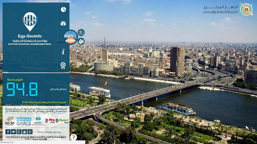
20 Home-page
 Establishments (profitable and non profitable) Thematic maps of census")
21 Main Sections Housing (buildings and dwellings) Population (households and individuals) Establishments (profitable and non profitable) Thematic maps of census 2017 results
22 Changing colour scheme more flexibility to the user analysis and needs. Thematic maps of census 2017 results
23 Who are the achievers and who are the laggers? Thematic maps of census 2017 results
24 Supporting statistical Confidence Interval Approach to categorize variable domain Thematic maps of census 2017 results

25 Multi-geo-dimensional analysis Does this phenomenon is correlated to another causeeffect? Thematic maps of census 2017 results
26 Thematic maps of census 2017 results

27 Supporting OPEN-DATA Thematic maps of census 2017 results
28 Flexible statistical visualization Thematic maps of census 2017 results

29 Infinite number of advancingsearch conditions From where we should to start? Thematic maps of census 2017 results
30 Dynamic reporting Thematic maps of census 2017 results

31 Interactive and integrated widgets Thematic maps of census 2017 results
32 Alternatives of geographical division Thematic maps of census 2017 results

33 This comparison shows how the accuracy of the gridding approach versus the conventional administrative divisions. The ultimate importance of such gridding system crystalizes when chronic society problems are being investigated at the gross-rotes. As this approach is considered more reliable in directing the development interventions. Thematic maps of census 2017 results

34 In-depth diving in geographical division Thematic maps of census 2017 results


35 High correlated relationship between total number of building, and the owning of the dwellings. Means no biasness toward high- socio-economic levels regarding the housing ownership. Thematic maps of census 2017 results

36 In-depth diving in geographical division Thematic maps of census 2017 results

37 Nine categories of basic services and public facilities How the population is being served? Spatial maps of census 2017 results

38 Geographical distribution of the service/ facility. Where is the uncovered areas? Where are the high- versus lowdensity of providers counts? Spatial maps of census 2017 results
39 Supporting the feature s characteristics, based on the statistical privacy conditions Spatial maps of census 2017 results

40 Supporting master-sample preparation, and other censuses. Spatial maps of census 2017 results

41 Support buffering-zone for 1, 2, 3, 4, and 5 km. Target main services and facilities for public and private providers. Spatial maps of census 2017 results
42 Where are the overloaded service/ facilities? Where are the areas of noncoverage based on SLA? National classification of buffering loads? Spatial maps of census 2017 results

43 Supporting individual identification Spatial maps of census 2017 results

44 Supporting individual case-study Spatial maps of census 2017 results

45 Supporting custom-area characteristics Spatial maps of census 2017 results
46 Not less than 800 indicators Not less than 3000 time-series Calendar-based statistics to Fiscal-based statistics 2011 to 2016 Thematic maps for the System of Official Statistics
47 Social Sectors Higher education Social services Culture Social services Population Vital statistics Basic education Secondary education Vocational education Economic Sectors MSMEs Labour market Industry ICT Agricultural Thematic maps for the System of Official Statistics

48 Thematic maps for the System of Official Statistics
49 Thematic maps for the System of Official Statistics

50 Two different scenarios of unemployment. If a geographical place is interesting to be covered by development policies, thence unemployment rates will be targeted. If the objective is to affect on the national figure of unemployment, thence the mass-unemployed should be targeted, means the proportion of unemployed in county to the national figure of unemployed candidates is of interest. Thematic maps for the System of Official Statistics


51 Acknowledgments Wall Loading


52 Why we are here? What is our message? We here to Share Collaborate Learn together 2063 Africa we Want


")


53 Talaat Harb Founder of first bank in Egypt (1920) Thanks From the land of five thousand years of civilization the land of Pharaohs
Second High Level Forum on GGIM Seminar on Regional Cooperation in Geospatial Information Management Doha, Qatar, 7 February 2013
 Second High Level Forum on GGIM Seminar on Regional Cooperation in Geospatial Information Management Doha, Qatar, 7 February 2013 Overview on Geospatial Activities in Egypt BY : Eng.Nahla Seddik Mohamed
Integration for Informed Decision Making
 Geospatial and Statistics Policy Intervention: Integration for Informed Decision Making Greg Scott Global Geospatial Information Management United Nations Statistics Division Department of Economic and
Understanding China Census Data with GIS By Shuming Bao and Susan Haynie China Data Center, University of Michigan
 Understanding China Census Data with GIS By Shuming Bao and Susan Haynie China Data Center, University of Michigan The Census data for China provides comprehensive demographic and business information
The Global Statistical Geospatial Framework and the Global Fundamental Geospatial Themes
 The Global Statistical Geospatial Framework and the Global Fundamental Geospatial Themes Sub-regional workshop on integration of administrative data, big data and geospatial information for the compilation
Indicator: Proportion of the rural population who live within 2 km of an all-season road
 Goal: 9 Build resilient infrastructure, promote inclusive and sustainable industrialization and foster innovation Target: 9.1 Develop quality, reliable, sustainable and resilient infrastructure, including
Colin Bray, OSi CEO. Articulating the Data Needs for SDGs. Collaboration in Ireland
 Ireland Colin Bray, OSi CEO Articulating the Data Needs for SDGs Collaboration in Ireland Articulating the Data Needs for SDGs Ireland Introduction Collaboration between the Irish National Mapping Agency
Ministry of Health and Long-Term Care Geographic Information System (GIS) Strategy An Overview of the Strategy Implementation Plan November 2009
 Strategy An Overview of the Strategy Implementation Plan November 2009") Ministry of Health and Long-Term Care Geographic Information System (GIS) Strategy An Overview of the Strategy Implementation Plan November 2009 John Hill, Health Analytics Branch Health System Information
Ministry of Health and Long-Term Care Geographic Information System (GIS) Strategy An Overview of the Strategy Implementation Plan November 2009 John Hill, Health Analytics Branch Health System Information
GEOGRAPHIC INFORMATION SYSTEMS Session 8
 GEOGRAPHIC INFORMATION SYSTEMS Session 8 Introduction Geography underpins all activities associated with a census Census geography is essential to plan and manage fieldwork as well as to report results
Ministry of ICT of I.R.IRAN
 The ECO 8/6 mill km 2 10 Slamic countries ~330 mill people Oil, Gas, Industries,Tourism 2 Issue transformation in last decade Problem solving needs more integrated approach More interaction &complexity
THE ROLE OF GEOSPATIAL AT THE WORLD BANK
 THE ROLE OF GEOSPATIAL AT THE WORLD BANK INSPIRE Conference Barcelona, Spain September 26, 2016 Kathrine Kelm Senior Land Administration Specialist Global Land and Geospatial Unit The World Bank Group
Land Use in the context of sustainable, smart and inclusive growth
 Land Use in the context of sustainable, smart and inclusive growth François Salgé Ministry of sustainable development France facilitator EUROGI vice president AFIGéO board member 1 Introduction e-content+
Measuring Poverty. Introduction
 Measuring Poverty Introduction To measure something, we need to provide answers to the following basic questions: 1. What are we going to measure? Poverty? So, what is poverty? 2. Who wants to measure
Brazil Paper for the. Second Preparatory Meeting of the Proposed United Nations Committee of Experts on Global Geographic Information Management
 Brazil Paper for the Second Preparatory Meeting of the Proposed United Nations Committee of Experts on Global Geographic Information Management on Data Integration Introduction The quick development of
Geography for the 2020 Round of Census
 Boundaries Key Census Data EA Id Population Male Female EA Id Area EA Id Num HH Avg HH size Geography for the 2020 Round of Census Linda Peters, Esri lpeters@esri.com Integration of Statistical and Geospatial
KENYA NATIONAL BUREAU OF STATISTICS Workshop on
 KENYA NATIONAL BUREAU OF STATISTICS Workshop on Capacity Building in Environment Statistics: the Framework for the Development of Environment Statistics (FDES 2013) Coordination with Sector Ministries
Spatially Enabled Society
 International Seminar on Land Administration Trends and Issues in Asia and the Pacific Region Spatially Enabled Society Abbas Rajabifard Vice Chair PCGIAP-WG3 Vice-President (President Elect), GSDI Association
Combining Geospatial and Statistical Data for Analysis & Dissemination
 Combining Geospatial and Statistical Data for Analysis & Dissemination (with Special Reference to Qatar Census 2010) Presentation by Mansoor Al Malki, Director of IT Department Qatar Statistics Authority
INDONESIA S S UPDATE: GEOSPATIAL INFORMATION FOR SUSTAINABLE DEVELOPMENT RELATED TO INA SDI Dr. Asep Karsidi, M.Sc
 INDONESIA S S UPDATE: GEOSPATIAL INFORMATION FOR SUSTAINABLE DEVELOPMENT RELATED TO INA SDI Dr. Asep Karsidi, M.Sc GEOSPATIAL INFORMATION AGENCY 08 August, 2012 OUTLINE 1. Transformation Bakosurtanal into
Challenges and Potentials of Place Based Information Management in Nepal"
 Nineteenth United Nations Regional Cartographic Conference for Asia and the Pacific, Bangkok, Thailand, 29 October 1 November 2012 Challenges and Potentials of Place Based Information Management in Nepal"
Compact guides GISCO. Geographic information system of the Commission
 Compact guides GISCO Geographic information system of the Commission What is GISCO? GISCO, the Geographic Information System of the COmmission, is a permanent service of Eurostat that fulfils the requirements
Economic and Social Council
 United Nations Economic and Social Council Distr.: General 18 July 2016 Original: English Committee of Experts on Global Geospatial Information Management Sixth session New York, 3-5 August 2016 Item 2
Qatar Statistical Geospatial Integration
 Qatar Statistical Geospatial Integration A Presentation by the Ministry of Development Planning & Statistics (MDPS), State of Qatar http://www.mdps.gov.qa (Fourth UN-GGIM Arab States Committee Meeting,
THE SPATIAL DATA WAREHOUSE OF SEOUL
 THE SPATIAL DATA WAREHOUSE OF SEOUL Jae-Ho Han The Seoul Metropolitan Government Seoul City Hall, Taepyeongno 1(il)-ga, Jung-gu, Seoul 100-744, Korea djhjha@hanmail.net Impyeong Lee Dept. of Geoinformatics,
Building a National Data Repository
 Building a National Data Repository Mladen Stojic, Vice President - Geospatial 1/30/2013 2012 Intergraph Corporation 1 Information has meaning and gives power only when shared and distributed. Information,
Presentation by Thangavel Palanivel Senior Strategic Advisor and Chief Economist UNDP Regional Bureau for Asia-Pacific
 Presentation by Thangavel Palanivel Senior Strategic Advisor and Chief Economist UNDP Regional Bureau for Asia-Pacific The High-Level Euro-Asia Regional Meeting on Improving Cooperation on Transit, Trade
Egyptian E-Census 2017
 Egyptian E-Census 2017 Central Agency for Public Mobilization And Statistics An Integration between Spatial and Statistical information Prepared by: Nahla Seddik Mohamed General Director Mennat-Allah Anwar
The Integrated Ge spatial Information Framework to the strengthening of NSDI, Mongolia
 Young Geospatial Professionals Summit 21 NOV 2018 The Integrated Ge spatial Information Framework to the strengthening of NSDI, Mongolia BAYARMAA ENKHTUR Geospatial information and technology department
Proposal for a DIRECTIVE OF THE EUROPEAN PARLIAMENT AND OF THE COUNCIL. establishing an infrastructure for spatial information in the Community
 Proposal for a DIRECTIVE OF THE EUROPEAN PARLIAMENT AND OF THE COUNCIL establishing an infrastructure for spatial information in the Community INSPIRE http://inspire.jrc.it/ Alessandro Annoni 1 EU Commission
Disaster Management & Recovery Framework: The Surveyors Response
 Disaster Management & Recovery Framework: The Surveyors Response Greg Scott Inter-Regional Advisor Global Geospatial Information Management United Nations Statistics Division Department of Economic and
Realizing benefits of Spatial Data Infrastructure A user s perspective from Environment Agency - Abu Dhabi
 Realizing benefits of Spatial Data Infrastructure A user s perspective from Environment Agency - Abu Dhabi Anil Kumar Director, Environment Information Management 26 April 2012 Geospatial World Forum,
Big-Geo-Data EHR Infrastructure Development for On-Demand Analytics
 Big-Geo-Data EHR Infrastructure Development for On-Demand Analytics Sohayla Pruitt, MA Senior Geospatial Scientist Duke Medicine DUHS DHTS EIM HIRS Page 1 Institute of Medicine, World Health Organization,
Building the Sustainable Network of Settlements on the Caspian Sea Region of Kazakhstan
 Building the Sustainable Network of Settlements on the Caspian Sea Region of Kazakhstan Introduction The Ecological Zoning and Identification of Ecological Capacity of Natural and Socio- Economic Potential
TheEuropean Location Framework
 TheEuropean Location Framework Presentation to: Author: Date: TN-ITS/INSPIRE session at INSPIRE Conference Olaf Magnus Østensen, ELF co-ordinator 18 June2014 The ELF project 15 national mapping authorities
Working with Census Operations Case Study from KSA
 Working with Census Operations Case Study from KSA International Workshop on Integrating Geospatial and Statistical Information Beijing 9 12 June 2014 Abdullah M.Alhamlan Kingdom of Saudi Arabia Central
Spatial Statistical Information Services in KOSTAT
 Distr. GENERAL WP.30 12 April 2010 ENGLISH ONLY UNITED NATIONS ECONOMIC COMMISSION FOR EUROPE (UNECE) CONFERENCE OF EUROPEAN STATISTICIANS EUROPEAN COMMISSION STATISTICAL OFFICE OF THE EUROPEAN UNION (EUROSTAT)
SPLAN-Natura Towards an integrated spatial planning approach for Natura th January, 2017 Brussels. Commissioned by DG Environment
 SPLAN-Natura 2000 Towards an integrated spatial planning approach for Natura 2000 Commissioned by DG Environment 17 th January, 2017 Brussels V. Simeonova (Ph.D.) Drivers towards integrating Biodiversity
compass.durhamnc.gov Building Community by Illustrating Community Durham s Neighborhood Compass
 Building Community by Illustrating Community Durham s Neighborhood Compass A presentation by John Killeen Rob Cushman Tyler Waring Neighborhood Improvement Services & Technology Solutions City of Durham,
Department of Statistics Malaysia
 Department of Statistics Malaysia 1 2 1 2 3 4 5 Introduction Geographic Information Systems (GIS) Geospatial activities for 2020 Modernisation Way Forward 3 Malaysia Population (Millions) Census 2010 2018
Principle 3: Common geographies for dissemination of statistics Poland & Canada. Janusz Dygaszewicz Statistics Poland
 Principle 3: Common geographies for dissemination of statistics Poland & Canada Janusz Dygaszewicz Statistics Poland Reference materials Primary: Ortophotomap, Cadastral Data, Administrative division borders,
The World Bank Health System Strengthening and Support Project (P152799)
") Public Disclosure Authorized EUROPE AND CENTRAL ASIA Turkey Health, Nutrition & Population Global Practice IBRD/IDA Investment Project Financing FY 2016 Seq No: 3 ARCHIVED on 23-Dec-2016 ISR25849 Implementing
Public Disclosure Authorized EUROPE AND CENTRAL ASIA Turkey Health, Nutrition & Population Global Practice IBRD/IDA Investment Project Financing FY 2016 Seq No: 3 ARCHIVED on 23-Dec-2016 ISR25849 Implementing
Country Report on SDI Activities in Singapore *
 UNITED NATIONS E/CONF.100/CRP.9 ECONOMIC AND SOCIAL COUNCIL Eighteenth United Nations Regional Cartographic Conference for Asia and the Pacific Bangkok, 26-29 October 2009 Item 7(a) of the provisional
The European Forum for Geospatial Statistics Benefits and challenges of INSPIRE in the field of statistics
 INSPIRE Conference 2016 Barcelona, Spain 26th 30th September 2016 The European Forum for Geospatial Statistics Benefits and challenges of INSPIRE in the field of statistics Janusz Dygaszewicz EFGS President
Presented to Sub-regional workshop on integration of administrative data, big data and geospatial information for the compilation of SDG indicators
 Presented to Sub-regional workshop on integration of administrative data, big data and geospatial information for the compilation of SDG indicators 23-25 April,2018 Addis Ababa, Ethiopia By: Deogratius
UNCTAD Single-year Expert Meeting on Tourism s Contribution to Sustainable Development
 UNCTAD Single-year Expert Meeting on Tourism s Contribution to Sustainable Development Geneva, Palais des Nations, Salle XXVI, 14-15 March 2013 Zoritsa Urosevic Head, Institutional & Corporate Relations,
Country Report.
 Country Report www.statsfiji.gov.fj Communication and Advocacy for Agriculture and Rural Statistics 27 June -01 July, 2016, Daejeon, Republic of Korea Outline Brief Introduction National Statistical System
Labour Market Areas in Italy. Sandro Cruciani Istat, Italian National Statistical Institute Directorate for territorial and environmental statistics
 Labour Market Areas in Italy Sandro Cruciani Istat, Italian National Statistical Institute Directorate for territorial and environmental statistics Workshop on Developing European Labour Market Areas Nuremberg,
INSPIRE Basics. Vlado Cetl European Commission Joint Research Centre. https://ec.europa.eu/jrc/
 INSPIRE Basics Vlado Cetl European Commission Joint Research Centre https://ec.europa.eu/jrc/ Serving society Stimulating innovation Supporting legislation Outline SDI? Why European SDI? INSPIRE Policy
2018/1 The integration of statistical and geospatial information. The Regional Committee of UN-GGIM: Americas:
 The following are the conclusions and recommendations of the Regional Committee of the United Nations on Global Geospatial Information Management for the Americas, during its Fifth Session, Thursday 8
Methodological issues in the development of accessibility measures to services: challenges and possible solutions in the Canadian context
 Methodological issues in the development of accessibility measures to services: challenges and possible solutions in the Canadian context Alessandro Alasia 1, Frédéric Bédard 2, and Julie Bélanger 1 (1)
ArcGIS Platform For NSOs
 ArcGIS Platform For NSOs Applying GIS and Spatial Thinking to Official Statistics Esri UC 2014 Demo Theater Applying GIS at the NSO Generic Statistical Business Process Model (GSBPM) 1 Specify Needs 2
Locational business intelligence in the U.S. Forest Service: Geospatial Accomplishment Reporting ESRI USER CONFERENCE 2015 JULY 21, 2015
 Locational business intelligence in the U.S. Forest Service: Geospatial Accomplishment Reporting ESRI USER CONFERENCE 2015 JULY 21, 2015 Agenda Introduction to the US Forest Service Why geo-enable Performance
The GIS Path Forward Saskatchewan s Geomatics Strategic Plan
 The GIS Path Forward Saskatchewan s Geomatics Strategic Plan John Potter, SK Ministry of Central Services Office of Geomatics Coordination Sept.17/13 Table of Contents 1. 2011-2016, Geomatics Strategic
Proposed Scope of Work Village of Farmingdale Downtown Farmingdale BOA Step 2 BOA Nomination Study / Draft Generic Environmental Impact Statement
 Proposed Scope of Work Village of Farmingdale Downtown Farmingdale BOA Step 2 BOA Nomination Study / Draft Generic Environmental Impact Statement The scope of work that follows incorporates and covers
CLICK HERE TO KNOW MORE
 CLICK HERE TO KNOW MORE GeoSpace for Singapore s Whole-of-Government Data Sharing Asia GeoSpatial Forum 17 19 Oct 2011 Lee Kim Haw Singapore Land Authority Introducing Singapore Land Authority Limited
The Socio Economic Development of the Marine Sector in the Atlantic Area. Stephen Hynes
 The Socio Economic Development of the Marine Sector in the Atlantic Area Stephen Hynes Overview SEMRU and its role in Marine Socioeconomic analysis Defining Ocean and Coastal Economies in the Atlantic
Climate Resilience Decision Making Framework in the Caribbean. A case of Spatial Data Management
 Climate Resilience Decision Making Framework in the Caribbean A case of Spatial Data Management Bishwa Pandey Sr. Data Management Specialist The World Bank Background The mission of The World Bank s Latin
Joanne N. Halls, PhD Dept. of Geography & Geology David Kirk Information Technology Services
 Joanne N. Halls, PhD Dept. of Geography & Geology David Kirk Information Technology Services Geographic Information Systems manage and analyze data to solve spatial problems. Real World Abstraction Analysis
Creating a Staff Development Plan with Esri
 Creating a Staff Development Plan with Esri Michael Green David Schneider Guest Presenter: Shane Feirer, University of California Esri UC 2014 Technical Workshop Agenda What is a Staff Development Plan?
Implementation of the ESPON 2020 cooperation program. 16 January 2017 Anneloes van Noordt
 Implementation of the ESPON 2020 cooperation program 16 January 2017 Anneloes van Noordt Outline! ESPON Cooperation Program! Specific Objectives! Applied Research! Targeted Analysis! Database & Tools!
LandScan Global Population Database
 LandScan Global Population Database The World s Finest Population Distribution Data Uncommon information. Extraordinary places. LandScan Global Population Database East View Cartographic is now offering
UN GGIM and National SDI Strategy
 MSDI Open Forum on 26 th January 2016 Contributing to the successful delivery of MSDI UN GGIM and National SDI Strategy Hiroshi Murakami Deputy Administrator Geospatial Information Authority of Japan Geospatial
Implementing the Sustainable Development Goals: The Role of Geospatial Technology and Innovation
 Fifth High Level Forum on UN Global Geospatial Information Management Implementing the Sustainable Development Goals: The Role of Geospatial Technology and Innovation 28-30 November 2017 Sheraton Maria
Exploring GIS Potential for Northwestern Ontario Land Information Ontario
 Exploring GIS Potential for Northwestern Ontario Land Information Ontario May 13, 2015 The LIO Vision LIO Vision: That all geographic information about Ontario is fully integrated and accessible LIO Goal:
Spatial Data Availability Energizes Florida s Citizens
 NASCIO 2016 Recognition Awards Nomination Spatial Data Availability Energizes Florida s Citizens State of Florida Agency for State Technology & Department of Environmental Protection Category: ICT Innovations
Open spatial data infrastructure
 Open spatial data infrastructure a backbone for digital government Thorben Hansen Geomatikkdagene 2018 Stavanger 13.-15. mars Spatial Data Infrastructure definition the technology, policies, standards,
Set-up of subnational statistical systems Statistical Development Strategy for the State of Jalisco México, 2016
 Set-up of subnational statistical systems Statistical Development Strategy for the State of Jalisco México, 2016 Statistical and Geographical Information Institute of Jalisco (IIEG) 2013. Merger of three
a national geological survey perspective François ROBIDA BRGM (French Geological Survey)
") a national geological survey perspective François ROBIDA BRGM (French Geological Survey) Pre-Conference Seminar on Socio-Economic Value of Geospatial for National and Regional Development 21 August 2017,
a national geological survey perspective François ROBIDA BRGM (French Geological Survey) Pre-Conference Seminar on Socio-Economic Value of Geospatial for National and Regional Development 21 August 2017,
Introducing the WISERD Geoportal. WISERD DATA TEAM Dr Robert Berry & Dr Richard Fry, University of Glamorgan Dr Scott Orford, Cardiff University
 Introducing the WISERD Geoportal WISERD DATA TEAM Dr Robert Berry & Dr Richard Fry, University of Glamorgan Dr Scott Orford, Cardiff University WISERD What is WISERD? Wales Institute of Social and Economic
Public Disclosure Copy. Implementation Status & Results Report Tanzania: Resilient Natural Resource Management for Tourism and Growth (P150523)
") Public Disclosure Authorized AFRICA Tanzania Environment & Natural Resources Global Practice IBRD/IDA Investment Project Financing FY 2018 Seq No: 1 ARCHIVED on 05-Dec-2017 ISR30455 Implementing Agencies:
Public Disclosure Authorized AFRICA Tanzania Environment & Natural Resources Global Practice IBRD/IDA Investment Project Financing FY 2018 Seq No: 1 ARCHIVED on 05-Dec-2017 ISR30455 Implementing Agencies:
Geospatial Information and Services for Disasters (GIS4D)
") Geospatial Information and Services for Disasters (GIS4D) 31 July 2017 Tae Hyung KIM ICT and Disaster Risk Reduction Division (IDD) UNESCAP 1 About ESCAP Who is ESCAP? United Nations Economic and Social
Geospatial Information and Services for Disasters (GIS4D) 31 July 2017 Tae Hyung KIM ICT and Disaster Risk Reduction Division (IDD) UNESCAP 1 About ESCAP Who is ESCAP? United Nations Economic and Social
An online data and consulting resource of THE UNIVERSITY OF TOLEDO THE JACK FORD URBAN AFFAIRS CENTER
 An online data and consulting resource of THE JACK FORD URBAN AFFAIRS CENTER THE CENTER FOR GEOGRAPHIC INFORMATION SCIENCE AND APPLIED GEOGRAPHICS DEPARTMENT OF GEOGRAPHY AND PLANNING THE UNIVERSITY OF
UN-GGIM: Strengthening Geospatial Capability
 Fifth Plenary Meeting of UN-GGIM: Europe Brussels, 6-7 June 2018 UN-GGIM: Strengthening Geospatial Capability Walking the talk to leave no one behind Greg Scott, UN-GGIM Secretariat Environmental Statistics
Country Report On Sdi Activities In Singapore ( )
") UNITED NATIONS E/CONF.102/IP.4 ECONOMIC AND SOCIAL COUNCIL Nineteenth United Nations Regional Cartographic Conference for Asia and the Pacific Bangkok, 29 October 1 November 2012 Item 6(b) of the provisional
UNITED NATIONS E/CONF.102/IP.4 ECONOMIC AND SOCIAL COUNCIL Nineteenth United Nations Regional Cartographic Conference for Asia and the Pacific Bangkok, 29 October 1 November 2012 Item 6(b) of the provisional
Statistical-geospatial integration - The example of Sweden. Marie Haldorson Director, Statistics Sweden
 Statistical-geospatial integration - The example of Sweden Marie Haldorson Director, Statistics Sweden Spatial data and geospatial applications at Statistics Sweden Long tradition GI integrated in production
Turkey s National SDI Implementation
 Onur PAŞAOĞULLARI Head of Department Turkey s National SDI Implementation Presentation Plan NSDI Background General Directorate of Geographic Information Systems NSDI Project INSPIRE Directive Urban Information
Oman NSDI Business Values and Future Directions. Hassan Alawi Alghazali Acting Director General National Spatial Data Infrastructure
 Oman NSDI Business Values and Future Directions Hassan Alawi Alghazali Acting Director General National Spatial Data Infrastructure Presentation Outline Geospatial Maturity Current Challenges NCSI s Role
Establishing the National Spatial Data Infrastructure (NSDI) for Norway a joint effort by many stakeholders SPATIAL DATA FOR BENEFIT OF THE SOCIETY
 for Norway a joint effort by many stakeholders SPATIAL DATA FOR BENEFIT OF THE SOCIETY") Establishing the National Spatial Data Infrastructure (NSDI) for Norway a joint effort by many stakeholders SPATIAL DATA FOR THE BENEFIT OF SOCIETY OUTLINE Political background Norway digital - The Norwegian
Establishing the National Spatial Data Infrastructure (NSDI) for Norway a joint effort by many stakeholders SPATIAL DATA FOR THE BENEFIT OF SOCIETY OUTLINE Political background Norway digital - The Norwegian
IHP-WINS will make water-related information available online, allowing countries and stakeholders to access reliable data on an open source platform.
 United Nations Educational, Scientific and Cultural Organization International Hydrological Programme International Hydrological Programme Water Information Network System INTERNATIONAL HYDROLOGICAL PROGRAMME
ADDRESSING THE DATA AND INFORMATION NEEDS FOR GOOD GOVERNANCE, SHARING EXPERIENCES FROM COTE D IVOIRE. 20 April 2016 to 22 April 2016 ADDIS ABABA
 20 April 2016 to 22 April 2016 ADDIS ABABA ADDRESSING THE DATA AND INFORMATION NEEDS FOR GOOD GOVERNANCE, SHARING EXPERIENCES FROM COTE D IVOIRE Dr. Edouard FONH-GBEI Director General of CNTIG, General
Demographic Data in ArcGIS. Harry J. Moore IV
 Demographic Data in ArcGIS Harry J. Moore IV Outline What is demographic data? Esri Demographic data - Real world examples with GIS - Redistricting - Emergency Preparedness - Economic Development Next
Standards in Action: The Canadian Geospatial Data Infrastructure (CGDI)
") Standards in Action: The Canadian Geospatial Data Infrastructure (CGDI) Craig Stewart ISO/TC211 Standards in Action Workshop, September 14, 2005 Presentation Outline Overview of SDIs Overview of Canada
Standards in Action: The Canadian Geospatial Data Infrastructure (CGDI) Craig Stewart ISO/TC211 Standards in Action Workshop, September 14, 2005 Presentation Outline Overview of SDIs Overview of Canada
Colin Bray, OSi CEO. Collaboration to develop a data platform for geospatial and statistical information in Ireland
 Colin Bray, OSi CEO Collaboration to develop a data platform for geospatial and statistical information in Ireland Organisations Ireland s National Mapping Agency Established in 1824 Operates under the
Government GIS and its Application for Decision Support
 Government GIS and its Application for Decision Support Zhang Qingpu (Chinese Academy of Surveying and Mapping, Email: zhangqp@casm.ac.cn) Abstract: Application of GIS in government agencies is called
Economic Benefit Study on Value of Spatial Information Australian Experience
 Economic Benefit Study on Value of Spatial Information Australian Experience Dr Zaffar Sadiq Mohamed-Ghouse Director, International Relations Cooperative Research Centre for Spatial Information zsadiq@crcsi.com.au
Achieving the Vision Geo-statistical integration addressing South Africa s Developmental Agenda. geospatial + statistics. The Data Revolution
 Achieving the Vision Geo-statistical integration addressing South Africa s Developmental Agenda geospatial + statistics The Data Revolution humble beginnings, present & future - South Africa UN World Data
KING FAHD UNIVERSITY OF PETROLEUM & MINERALS
 KING FAHD UNIVERSITY OF PETROLEUM & MINERALS Department of City & Regional Planning Introduction To GIS (CRP 514) Identifying & Planning Public School Facility In California Using GIS Presented to Dr.
The econ Planning Suite: CPD Maps and the Con Plan in IDIS for Consortia Grantees Session 1
 The econ Planning Suite: CPD Maps and the Con Plan in IDIS for Consortia Grantees Session 1 1 Training Objectives Use CPD Maps to analyze, assess, and compare levels of need in your community Use IDIS
KUNMING FORUM ON UNITED NATIONS GLOBAL GEOSPATIAL INFORMATION MANAGEMENT CITIES OF THE FUTURE: SMART, RESILIENT
 KUNMING FORUM ON UNITED NATIONS GLOBAL GEOSPATIAL INFORMATION MANAGEMENT CITIES OF THE FUTURE: SMART, RESILIENT and SUSTAINABLE Yunnan Zhenzhuang Guest House, Kunming, China 10 12 May 2017 BACKGROUND CONCEPT
Geospatial activities during the 47 th UN Statistical Commission
 Geospatial activities during the 47 th UN Statistical Commission A Summary Rolando Ocampo Alcántar April 2016 47 th Session of the United Nations Statistical Commission Side Events Friday Seminar on Emerging
MAPPING DATA AND INFORMATION SYSTEMS AVAILABILITY AGAINST THE SDGs
 MAPPING DATA AND INFORMATION SYSTEMS AVAILABILITY AGAINST THE SDGs Imelda Atai Musana Uganda Bureau of Statistics imelda.atai@ubos.org Date: November 2015 1 Introduction Uganda Lies Astride the Equator
Geographical Names: Relevance and place within the UN-GGIM framework
 Geographical Names: Relevance and place within the UN-GGIM framework Greg Scott Inter-Regional Advisor Global Geospatial Information Management United Nations Statistics Division UN-GGIM: A global initiative
Major Opportunities in Spatial Data Infrastructure Communities
 Major Opportunities in Spatial Data Infrastructure Communities Bas Kok President GSDI June 17 th 2008 FIG Working Week: Integrating Generations 14-19 June 2008 Stockholm, Sweden http://www.gsdi.org 1 GSDI
Development of a Unified Spatial Infrastructure Status Index for Developing Nations
 Development of a Unified Spatial Infrastructure Status Index for Developing Nations Mohamed ABDEL-SALAM, Canada and Mohamed MOSTAFA, Egypt Key words: Spatial information infrastructure, unified index,
GIS Capability Maturity Assessment: How is Your Organization Doing?
 GIS Capability Maturity Assessment: How is Your Organization Doing? Presented by: Bill Johnstone Principal Consultant Spatial Vision Group November 8, 2018 1. Motivation for Capability Maturity Models
The World Bank TOGO Community Development and Safety Nets Project (P127200)
") Public Disclosure Authorized AFRICA Togo Social Protection & Labor Global Practice IBRD/IDA Specific Investment Loan FY 2012 Seq No: 9 ARCHIVED on 16-Sep-2016 ISR25166 Implementing Agencies: Technical
Public Disclosure Authorized AFRICA Togo Social Protection & Labor Global Practice IBRD/IDA Specific Investment Loan FY 2012 Seq No: 9 ARCHIVED on 16-Sep-2016 ISR25166 Implementing Agencies: Technical
Statement. H.E Dr. Richard Nduhuura Permanent Representative of the Republic of Uganda to the United Nations New York
 Page1 UGANDA Permanent Mission of Uganda To the United Nations New York Tel : (212) 949 0110 Fax : (212) 687-4517 Statement By H.E Dr. Richard Nduhuura Permanent Representative of the Republic of Uganda
Oman NSDI Supporting Economic Development. Saud Al-Nofli Director of Spatial Data Directorate General of NSDI, NCSI
 Oman NSDI Supporting Economic Development 2017 Saud Al-Nofli Director of Spatial Data Directorate General of NSDI, NCSI "It s critical to make correct decisions the first time to optimize the Investments
Towards Reliable Spatial Database of Informal Areas in Greater Cairo Region
 KEYWORDS informal areas, unreliable spatial data, spatial data collecting, capacity building SUMMARY The uncontrolled and rapid increase of Egypt s cities is a major problem of the country. More than the
Public Disclosure Copy
 Public Disclosure Authorized AFRICA Malawi Transport & Digital Development Global Practice IBRD/IDA Investment Project Financing FY 2017 Seq No: 2 ARCHIVED on 23-May-2018 ISR32537 Implementing Agencies:
COUNTY SPATIAL DATA INFRASTRUCTURE PRESENTATION: BY: GEOFREY CHERUIYOT NAIROBI CITY COUNTY
 . COUNTY SPATIAL DATA INFRASTRUCTURE PRESENTATION: BY: GEOFREY CHERUIYOT NAIROBI CITY COUNTY FRAMEWORK FOR AN INTEGRATED SPATIAL DATA INFRASTRUCTURE County GIS GIS : A computer based information system