First on the Ground. Geomatics
|
|
|
- Godfrey Lambert
- 5 years ago
- Views:
Transcription

1 First on the Ground Geomatics
2
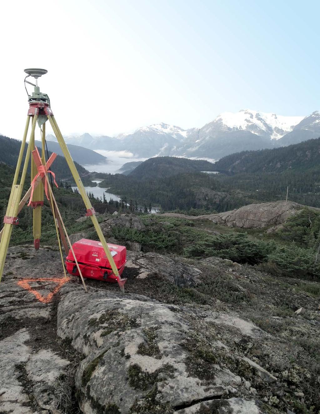
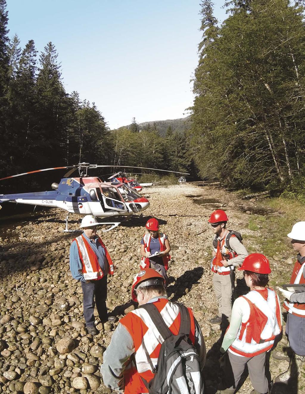
3 Surveying and mapping solutions spanning the entire project lifecycle Part art, part science, part technology, the Geomatics profession is constantly evolving. From the very first structures, early surveyors used primitive instruments and simple geometry to perform layouts and measurements. Today, advancing technology and field-to-finish data management enables our Geomatics professionals to deliver measurements unparallel in accuracy. From municipal development, to industrial construction and to oil and gas specific projects, we work in all sectors and at all stages of the job. Our strong project teams and proven track record, coupled with our commitment to safety and ISO 9001:2008 aligned quality program, means that our clients can have full confidence that their projects will be completed safely, on time, on budget and be delivered as a high-quality product. Having access to project-critical data from the office at all times means efficient communication and project management, as well as minimal errors and timeline overruns. A unique part of our approach to surveying includes the development and use of custom GIS tools and applications that allow this level of project knowledge. Using the best in survey technology and having access to award-winning GIS developers, no job is too large or complex for our team. Safety is a big part of who we are. Our safety program is ingrained in our culture, encompassing management, to junior staff and from office support to field operations. Our track record proves that we are committed, at all levels of our organization, to the health and safety of our employees. 01


4 Our project experience LAMÈQUE WIND POWER Lamèque, NB Client: Acciona Energy K+S LEGACY MINE Regina, SK Client: aecon, keller, graham, pcl The project consisted of thirty 1.5-megawatt wind turbines, a large electrical substation, kilometres of access roads and underground collector system corridors, as well as kilometres of a new transmission line corridor. WSP s role was to supply layout for clearing all turbine sites and corridors, and perform legal and topographic surveys. LiDAR was used to generate contours across the site and WSP performed field verification using conventional survey methods. A lease was created for each turbine site, as well as corridor easements and rights of way for the access roads and power corridor. WSP provided surveying services for the construction of this $4.1B Greenfield solution potash mine. Breaking ground in 2012, WSP was in the field with the early earthworks for the main site and the camp site, and carried on to all the piling (approximately 2,600 piles), foundations, underground facilities, well pads, and ponds. 02 Left page photo: Cogswell Street Interchange Redevelopment, Halifax, NS Right page photo: Thompson Flats UAV Mapping, Kelowna, BC

5 PRINCE RUPERT GAS TRANSMISSION (PRGT) MAJOR TRANSPORTATION PROJECTS THE BOW Northern BC Client: TransCanada Pipelines Ontario Client: Ministry Of Transportation Ontario Calgary, AB Client: supreme walters joint venture ledcor construction ltd. WSP has worked with TransCanada on new projects and existing infrastructure within its vast network. On the PRGT project, WSP provided scouting, preliminary design, survey, preliminary mapping products and survey plans, and crossing surveys through over kilometres of rugged terrain from Hudson s Hope to British Columbia s northern coast. WSP has been providing Geomatics services to the Ministry of Transportation in Ontario for over 20 years. In conjunction with WSP s Transportation team, WSP Geomatics has successfully completed hundreds of highway, bridge and interchange projects throughout the province. Geomatics services include photogrammetric base mapping, legal surveys, topographic and preengineering surveys, GIS support, laser scanning, mobile mapping, alignment staking, base plans and DTM creation and ongoing geomatics support throughout the entire project s lifecycle. WSP provided professional Geomatics services on The Bow, a $1.4B crescent shaped, steelframe tower, on many aspects of the construction including the establishment and maintenance of the precise exterior control network. The control network was comprised of external stable control monuments installed and coordinated by WSP. In addition, the external control network was augmented through the installation, coordination, and maintenance of a network of rooftop, degree prisms on neighbouring buildings. 03
6 06
7 WSP delivers geomatics solutions to some of the largest projects in Canada. We are proud to have a premier reputation and long-term relationships with our clients. 21 Geomatics Offices Across Canada Left page photo: Prince Rupert Gas Transmission, Prince Rupert, BC 05
8 Geomatics services are an essential element to any engineering project no matter how large or small. WSP is the leader and the premier choice for geomatics solutions in Canada. First on the ground, WSP goes where your projects are because geomatics is more than a profession it s a way of life.
9 Core services GIS QA Survey 3D Modelling Legal Survey Hydrographic Survey Civil Earthworks Construction Survey Engineering Survey Facility As-built Line Locating Asset Management Topographic Survey Specialized Services OIL & GAS Wellsites Survey Pipeline Routing Access Roads Facility Survey Plan Production & Mapping PIPELINE Route Selection Pre-legal & Design Survey Regulatory Application Plans Construction Flagging & As-built Integrity Survey MINING & INDUSTRIAL Site Preparation & Layout Above & Below Ground Utilities 3D Laser Scan Survey Foundation & Piling Layout High Precision Anchor Bolt Layout TRANSPORTATION & INFRASTRUCTURE Heavy Rail & LRT Corridor Pre-engineering & Detailed Design Surface Modelling & Quantities Airport Mapping & Regulatory Survey Deformation & Settlement Monitoring ENERGY Substation Staking Structure Staking Control Framework Design & Implementation Land Acquisition Plans Cultural & Environmental Feature Mapping GEOSPATIAL Bathymetric Survey Laser Scanning & Mobile Scanning Unmanned Aerial Vehicle (UAV) Utility Mapping & Verification (Ground Penetrating Radar) Remote Sensing 07

10 WSP is one of the world s leading professional services consulting firms. We are dedicated to our local communities and propelled by international brainpower. We are technical experts and strategic advisors including engineers, technicians, scientists, project managers, planners, surveyors and environmental specialists, as well as other design and program management professionals. We design and deliver lasting solutions in the Buildings, Transportation, Infrastructure, Oil & Gas, Environment, Geomatics, Mining, Power and Industrial sectors as well as project delivery and strategic consulting services. With over 7,500 talented people across Canada and 36,000 globally, we engineer projects that will help societies grow for generations to come. wsp.com 2017 WSP Canada Inc. All rights reserved. TM is a trademark of WSP Global Inc.
GEOMATICS SURVEYING AND MAPPING EXPERTS FOR OVER 35 YEARS
 GEOMATICS SURVEYING AND MAPPING EXPERTS FOR OVER 35 YEARS 2 GEOMATICS AND SURVEYING SOLUTIONS SPANNING THE ENTIRE PROJECT LIFECYCLE 1,000+ 250+ 24 Surveying professionals Active field crews Geomatics offices
Exploring the boundaries of your built and natural world. Geomatics
 Exploring the boundaries of your built and natural world Geomatics Before the Luxor brought magic to the Las Vegas strip and before the South LRT extension in Edmonton gave residents a new route to travel,
P R O U D LY C A N A D I A N
 P R O U D LY C A N A D I A N 1.855.423.3185 info@rmegeomatics.com AERIAL SURVEYING IMAGING TERRAIN ANALYSIS WHO WE ARE HSE & REGULATORY CLIENT INDUSTRIES RME Geomatics (formerly NGF Geomatics) was founded
A Broad View of Geospatial Technology & Systems
 A Broad View of Geospatial Technology & Systems Pete Large Vice President, Trimble On the shoulders of giants 1 Since their time, our ability to generate geospatial information has grown exponentially
GEOMATICS. Shaping our world. A company of
 GEOMATICS Shaping our world A company of OUR EXPERTISE Geomatics Geomatics plays a mayor role in hydropower, land and water resources, urban development, transport & mobility, renewable energy, and infrastructure
Crossrail C430 Advanced Works Farringdon, London
 Crossrail C430 Advanced Works Farringdon, London Presented By: Colin Murphy Director Tel: Office: +44 (0)20 3178 6644 Mobile: +44 (0)79 4410 0891 Email: cmurphy@murphysurveys.co.uk Key Facts: Client: Laing
T: E:
 PAS 128 UTILITY DETECTION AND MAPPING TOPOGRAPHICAL SURVEYS UTILITY RECORD SEARCHES AND DESK TOP STUDY SURFACE WATER DRAINAGE SURVEYS GROUND CLEARANCE SURVEYS MEASURED BUILDING SURVEYS LASER SCANNING UAV
Technical Drafting, Geographic Information Systems and Computer- Based Cartography
 Technical Drafting, Geographic Information Systems and Computer- Based Cartography Project-Specific and Regional Resource Mapping Services Geographic Information Systems - Spatial Analysis Terrestrial
May 2011 Oracle Spatial User Conference
 May 2011 Oracle Spatial User Conference Oracle Spatial User Conference! May 19, 2011 Ronald Reagan Building and International Trade Center Washington, DC USA May 2011 Oracle Spatial User Conference Francois
Construction Project Data Management
 Construction Project Data Management Establishing Foundations for an Asset Database Scot Twining Project Activities Supported by GIS Cadastral Mapping Proposed Pipeline Route Selection Right Of Way Acquisition
Land Surveying. Knowledge. Commitment. Excellence.
 Land Surveying Knowledge. Commitment. Excellence. www.kcepc.com Land Surveying KC s land surveying group is a leading provider of boundary and topographic surveying, base mapping, right-of-way mapping
GIS Capability Maturity Assessment: How is Your Organization Doing?
 GIS Capability Maturity Assessment: How is Your Organization Doing? Presented by: Bill Johnstone Principal Consultant Spatial Vision Group November 8, 2018 1. Motivation for Capability Maturity Models
INSPIRE in the context of EC Directive 2002/49/EC on Environmental Noise
 INSPIRE in the context of EC Directive 2002/49/EC on Environmental Noise Simon Shilton Acustica Ltd, United Kingdom Nigel Jones Extrium Ltd, United Kingdom About the Authors www.acustica.co.uk Acoustics
To achieve these Global Sustainable Development Goals, geospatial data are crucial.
 To achieve these Global Sustainable Development Goals, geospatial data are crucial. 2 http://www.globalgoals.org/ HIGH INCOME NATION SUSTAINABLE GROWTH SOCIALLY INCLUSIVE 3 http://etp.pemandu.gov.my/ 12
Laser Scanning Increased Confidence = Reduced Risk
 Laser Scanning Increased Confidence = Reduced Risk Matthew McCarter - Surveyor Working in survey industry 16 years Started laser scanning in 2000 Advisory committee for SPAR EU and GeoBusiness conferences
THE NEW CHALLENGES FOR THE HIGHER EDUCATION OF GEODESY IN UACEG SOFIA
 THE NEW CHALLENGES FOR THE HIGHER EDUCATION OF GEODESY IN UACEG SOFIA Ivan Kunchev University of Architecture, Civil Engineering and Geodesy, 1 Hristo Smirnenski Blvd., Sofia 1046, Bulgaria Abstract Report
State of Israel Ministry of Housing and Construction Survey of Israel. The Hydrological project case
 State of Israel Ministry of Housing and Construction Survey of Israel The Hydrological project case Survey of Israel Content Introduction To the Survey of Israel The operation assumptions The main responsibilities
Surveyors, Cartographers, Photogrammetrists, and Surveying and Mapping Technicians
 http://www.bls.gov/oco/ocos040.htm Surveyors, Cartographers, Photogrammetrists, and Surveying and Mapping Technicians * Nature of the Work * Training, Other Qualifications, and Advancement * Employment
Country Report on SDI Activities in Singapore *
 UNITED NATIONS E/CONF.100/CRP.9 ECONOMIC AND SOCIAL COUNCIL Eighteenth United Nations Regional Cartographic Conference for Asia and the Pacific Bangkok, 26-29 October 2009 Item 7(a) of the provisional
Update to the Association of Ontario Land Surveyors February 27, 2015 Deerhurst, Ontario
 1 Update to the Association of Ontario Land Surveyors February 27, 2015 Deerhurst, Ontario Peter Sullivan CLS, ALS, MBA Director General, Surveyor General Branch Earth Sciences Sector, Natural Resources
IC ARTICLE LAND SURVEYORS
 IC 25-21.5 ARTICLE 21.5. LAND SURVEYORS IC 25-21.5-1 Chapter 1. Definitions IC 25-21.5-1-1 Application of chapter Sec. 1. The definitions in this chapter apply throughout this article. As added by P.L.23-1991,
Renewable Energy Development and Airborne Wildlife Conservation
 Whitepaper ECHOTRACK TM RADAR ACOUSTIC TM SURVEILLANCE SYSTEM Renewable Energy Development and Airborne Wildlife Conservation Renewable energy developers must meet regulatory requirements to mitigate for
Airborne Corridor-Mapping. Planning and documentation of company infrastructure: precise, rapid, and cost effective
 Airborne Corridor-Mapping Planning and documentation of company infrastructure: precise, rapid, and cost effective Technology Airborne Laser-Scanning, digital orthophotos and thermal imaging: one flight
Developing GIS Software to Process Photogrammetric Point Cloud Data for Inventory Production
 Developing GIS Software to Process Photogrammetric Point Cloud Data for Inventory Production Kevin Lim, Ph.D. President and CTO Lim Geomatics Inc. 343 Preston Street, Floor 11, Ottawa, ON, K1S 1N4 Enhanced
Surveying for Civil Engineering. Esra Tunc Gormus, PhD
 Surveying for Civil Engineering Esra Tunc Gormus, PhD Working Fields for Surveying Engineers It is also called as Geomatics Engineering or Geodesy and Photogrammetry Engineering Making maps with right
Industry Trends and Direction: a quick look! John Whitehead Trimble Navigation Ltd.
 Industry Trends and Direction: a quick look! John Whitehead Trimble Navigation Ltd. Converging forces have placed geospatial information at the center of an evolving ecosystem Technology Societal Forces
CITY OF HAMILTON. PUBLIC WORKS DEPARTMENT Operations Division
 CITY OF HAMILTON PUBLIC WORKS DEPARTMENT Operations Division TO: Chair and Members Public Works Committee WARD(S) AFFECTED: CITY WIDE COMMITTEE DATE: December 2, 2013 SUBJECT/REPORT NO: Winter Control
Sample Header for slide
 Sample Header for slide Consultants in Geology and Engineering North Rim Strategic Sourcing Tabetha Stirrett, P. Geo. October 22, 2014 Outline Exploration Phases in the mining industry How North Rim is
Developing a Campus-wide Base Map for Planning, Design and Construction. June 21, 2007
 Developing a Campus-wide Base Map for Planning, Design and Construction June 21, 2007 Presenters Berent Pippert UCR Project Manager Capital and Physical Planning Academic Planning and Budget 951-827-2431
SOLUTIONS ADVANCED GIS. TekMindz are developing innovative solutions that integrate geographic information with niche business applications.
 ADVANCED GIS SOLUTIONS TekMindz are developing innovative solutions that integrate geographic information with niche business applications. TEK INDZ TM GIS Services Overview At the leading edge of geospatial
STATEMENT OF QUALIFICATIONS
 STATEMENT OF QUALIFICATIONS GSP Consulting Gary Poland - President 2050 Longley Lane #1603 Reno, NV 89502 Phone: (775) 857-1362 Cell: (775) 240-5880 Synergy Mapping Laddie Kent Vice President 6551 S. Revere
Impact Policies Enabling Value Enhancement of Geospatial Information in Canadian Economy and Society
 1 Impact Policies Enabling Value Enhancement of Geospatial Information in Canadian Economy and Society May 26, 2015 Prashant Shukle, Director General Canada Centre for Mapping and Earth Observation Increased
GIS Geographic Information Systems
 GIS Geographic Information Systems Connecting your Community Ruekert Mielke WAUKESHA WHO WE ARE DATE ESTABLISHED 1946 SERVING LOCAL PEOPLE. SOLVING LOCAL PROBLEMS. TYPE OF ORGANIZATION Ruekert & Mielke,
Unique Vaisala Global Lightning Dataset GLD360 TM
 Unique Vaisala Global Lightning Dataset GLD360 TM / THE ONLY LIGHTNING DETECTION NETWORK CAPABLE OF DELIVERING SUCH HIGH-QUALITY DATA ANYWHERE IN THE WORLD GLD360 provides high-quality lightning data anywhere
Geospatial Excellence
 Geospatial Excellence Reality Captured. Certainty Delivered. OUR SERVICES Airborne Survey AAM s diverse range of aerial survey technologies ensures the best tool is deployed to suit the accuracy, timeliness
Country Report On Sdi Activities In Singapore ( )
") UNITED NATIONS E/CONF.102/IP.4 ECONOMIC AND SOCIAL COUNCIL Nineteenth United Nations Regional Cartographic Conference for Asia and the Pacific Bangkok, 29 October 1 November 2012 Item 6(b) of the provisional
UNITED NATIONS E/CONF.102/IP.4 ECONOMIC AND SOCIAL COUNCIL Nineteenth United Nations Regional Cartographic Conference for Asia and the Pacific Bangkok, 29 October 1 November 2012 Item 6(b) of the provisional
Professional Land Surveyor
 Professional Land Surveyor Professional Land Surveyors establish official land, air space, and water boundaries. They write descriptions of land for deeds, leases, and other legal documents; define air
CANADIAN HYDROGRAPHIC SERVICE
 CANADIAN HYDROGRAPHIC SERVICE Surveying and Charting Canada s Waters Since 1883 Ilulisat Maritime Workshop 2017 The Importance and Need for Hydrography Denis Hains, Hydrographer General of Canada & Director
Why do we need measurements?
 CIVL 1101 Surveying - Introduction 1/5 Why do we need measurements? In science, measurement is the process of estimating or determining the magnitude of a quantity, such as length or mass, relative to
DEPARTMENT OF GEOLOGY AND MINERAL INDUSTRIES WAYS & MEANS SUBCOMMITTEE ON NATURAL RESOURCES MARCH 2, 2017
 DEPARTMENT OF GEOLOGY AND MINERAL INDUSTRIES WAYS & MEANS SUBCOMMITTEE ON NATURAL RESOURCES MARCH 2, 2017 1 ABOUT DOGAMI AGENCY MISSION, VISION & GOALS 2 Lidar image of a stream network along the Umpqua
COMPANY EXCEED EXPECTATIONS. SYSTEMATICALLY.
 COMPANY EXCEED EXPECTATIONS. SYSTEMATICALLY. Recognized as a leader in geomatics, Effigis has been providing innovative geospatial solutions since 1991. Earth observation services, infrastructure surveys,
 Boone County GIS has the right to inquire about and investigate the use of any requested products and deny access to anyone based on concerns relating to privacy, security, public health, public safety,
The Vaisala AUTOSONDE AS41 OPERATIONAL EFFICIENCY AND RELIABILITY TO A TOTALLY NEW LEVEL.
 The Vaisala AUTOSONDE AS41 OPERATIONAL EFFICIENCY AND RELIABILITY TO A TOTALLY NEW LEVEL. Weather Data Benefit For Society The four most important things about weather prediction are quality, reliability,
Geophysics. Geotechnics. Geophysics. Earthworks. Environment. Groundwater. Rock Mechanics. Integrated Practical Solutions
 Geophysics Geotechnics Environment Groundwater Rock Mechanics Geophysics Earthworks Integrated Practical Solutions Geophysics Services Our 50 years of experience gained over 100,000 completed projects,
AUCKLAND MOTORWAY EXTENSION NORTHLAND REGION, NEW ZEALAND
 LEAPFROG WORKS 1 CASE STUDY Case Study: Tonkin & Taylor and Beca Design JV Puhoi to Warkworth motorway AUCKLAND MOTORWAY EXTENSION NORTHLAND REGION, NEW ZEALAND 2 The 3D subsurface model encompasses the
GEOMATICS ENGINEERING / SURVEYING
 1 GEOMATICS ENGINEERING / SURVEYING CHAPTER 1 Dr. Muhammad Ashraf Javid Assistant Professor Department of Civil and Environmental Engineering Email: muhammad.javid@unizwa.edu.om 2 Geomatics Engineering
Surveyors and GIS Geeks What we need to know. Alyssa Martin, GISP, LEED BD+C AP, Nathan Wysocki
 Surveyors and GIS Geeks What we need to know Alyssa Martin, GISP, LEED BD+C AP, Nathan Wysocki Adversarial Relationship? Some sources Tension between surveying and GIS: A growing challenge Connecting the
Mining for Gold: Kenora s
 Photo Credit: Tom Thomson Photography www.tomthomson.com Mining for Gold: Kenora s Comeback Dryden, Ontario has a great future based on the gold being developed by Treasury Metals at its flagship Goliath
Sault Ste. Marie Community Information Utility. Paul Beach
 Sault Ste. Marie Community Information Utility Paul Beach Sault Ste. Marie Innovation Centre The Sault Ste. Marie Innovation Centre (SSMIC) is a nonprofit organization that involves key stakeholders including
STEREO ANALYST FOR ERDAS IMAGINE Stereo Feature Collection for the GIS Professional
 STEREO ANALYST FOR ERDAS IMAGINE Stereo Feature Collection for the GIS Professional STEREO ANALYST FOR ERDAS IMAGINE Has Your GIS Gone Flat? Hexagon Geospatial takes three-dimensional geographic imaging
THE USE OF GEOMATICS IN CULTURAL HERITAGE AND ARCHAEOLOGY FOR VARIOUS PURPOSES
 THE USE OF GEOMATICS IN CULTURAL HERITAGE AND ARCHAEOLOGY FOR VARIOUS PURPOSES FEBRUARY 2013 AL BEIDA GEOPLAN CONTENT Company Profile Concept Objectives and Strategies Data Production Methods Data Samples
TIMELINE OF GEOMASTER
 Introduction Introduction TIMELINE OF GEOMASTER GEOMASTER LLC was established in January 1998 as an integrated professional high-tech geodetic and geophysical surveying and related service provider based
GIS Geographical Information Systems. GIS Management
 GIS Geographical Information Systems GIS Management Difficulties on establishing a GIS Funding GIS Determining Project Standards Data Gathering Map Development Recruiting GIS Professionals Educating Staff
HKND Group Ltd Grand Canal Project
 HKND Group Ltd Grand Canal Project General Overview of Aerial Survey Project Managua, Nicaragua September 21 st 2015 Presented by: Jeff Elliott Managing Director CSA Global About CSA Global CSA Global
Unique Vaisala Global Lightning Dataset GLD360 TM
 Unique Vaisala Global Lightning Dataset GLD360 TM / THE ONLY LIGHTNING DETECTION NETWORK CAPABLE OF DELIVERING HIGH-QUALITY DATA ANYWHERE IN THE WORLD GLD360 provides high-quality lightning data anywhere
Excel Geomatics: Offering Excellence with Unique Consultancy & Services
 Excel Geomatics: Offering Excellence with Unique Consultancy & Services Providing consultancy and value Added Services using Remote Sensing, Photogrammetry and LiDAR in areas such as Agriculture, Forestry,
NEWS RELEASE. Province boosts winter highway safety measures
 For Immediate Release 2018TRAN0045-000567 April 4, 2018 NEWS RELEASE Province boosts winter highway safety measures VICTORIA Following an intense winter, the is undertaking several improvements to make
Product description: GSD-Property Map, layered raster List of contents
 L A N T M Ä T E R I E T 1 (9) D ate: D ocument version: 2011-04-08-1.4 Product description: GSD-Property Map, layered raster List of contents 1 General description... 3 1.1 Contents... 3 1.1.1 Administrative
Indicator: Proportion of the rural population who live within 2 km of an all-season road
 Goal: 9 Build resilient infrastructure, promote inclusive and sustainable industrialization and foster innovation Target: 9.1 Develop quality, reliable, sustainable and resilient infrastructure, including
Japan Construction Information Center
 Japan Construction Information Center A Framework for Data Coordination Method of Maintenance Data and 3D Conceptual Model on CIM Based Database July 2016 Japan Construction Information Center Foundation
Auckland Transport. Auckland Council. Statement of Evidence of Simon John Ferneyhough
 Under the Resource Management Act 1991 In the matter of Notices of Requirement to enable the construction, operation and maintenance of the City Rail Link Between Auckland Transport Requiring Authority
Ramani Geosystems. Putting Africa On The Map. Authorized Resellers
 Ramani Geosystems Putting Africa On The Map Authorized Resellers Ramani Profile Started in 1999 Aerial, Land Surveying & Mapping Solutions + 10 Countries in the region + 80 Staff working in projects Asset
Building a National Data Repository
 Building a National Data Repository Mladen Stojic, Vice President - Geospatial 1/30/2013 2012 Intergraph Corporation 1 Information has meaning and gives power only when shared and distributed. Information,
Florida Department of Transportation s
 Controls Conference - Hyatt Regency Savannah, Georgia - April 14-18, 2013 Florida Department of Transportation s 1) Virtual R/W Application Development 2) 3D Utility Mapping for 3D Design Update John Krause,
Preliminary Mineral Exploration on the Pickett Mountain Property T6R6 WELS, Penobscot County, Maine. Public Information Session December 5, 2017
 Preliminary Mineral Exploration on the Pickett Mountain Property T6R6 WELS, Penobscot County, Maine Public Information Session December 5, 2017 Outline of Presentation Wolfden Resources Corporation Who
Geographic information for Strasbourg : from historical land register to 3D GIS city modelling 09/07/2017
 Geographic information for Strasbourg : from historical land register to 3D GIS city modelling 09/07/2017 Table of contents 1. Introduction of Strasbourg 2. A century of land surveying and cadastre 3.
Sustainable and Harmonised Development for Smart Cities The Role of Geospatial Reference Data. Peter Creuzer
 Sustainable and Harmonised Development for Smart Cities The Role of Geospatial Reference Data Peter Creuzer 1. Introduction - Smart Cities and Geodata 2. Geodata in Germany 3. Examples 4. Data and Service
NCTCOG Regional GIS Meeting 6-Years and Going Strong. May 15, 2018 hosted by: Tarrant County
 NCTCOG Regional GIS Meeting 6-Years and Going Strong May 15, 2018 hosted by: Tarrant County Woolpert at a Glance 1911 Founded in Dayton, Ohio 25+ Offices across the nation 800+ Global employees 25+ OFFICES
7 GEOMATICS BUSINESS SOLUTIONS - ANNUAL REPORT 2006
 7 GEOMATICS BUSINESS SOLUTIONS - ANNUAL REPORT 2006 The Planning and Economic Development Committee recommends the adoption of the recommendation contained in the following report November 30, 2006, from
Efficiencies in Data Acquisition and Transformation
 Efficiencies in Data Acquisition and Transformation Andrew LEYZACK Canada Key words: Hydrography, IHO S-57, Nautical Chart SUMMARY For many hydrographic offices, the introduction of electronic nautical
SITE-SPECIFIC HAIL ANALYSIS
 SITE-SPECIFIC HAIL ANALYSIS PREPARED FOR: Beneficial Insurance Attn: Jeff Marker June 22, 2010 Case Reference: Burke #2307IY PROJECT INFORMATION Report Completion Date: June 22, 2010 Prepared for: Beneficial
Practical Uses of LiDAR in NL A Consultants Perspective
 Practical Uses of LiDAR in NL A Consultants Perspective Adam Anderson, R.P.F. President & CEO Presented by: Peter Davison, R.P.F. Photo Interpretation Specialist Introduction Resource Innovations Inc.
VISUALIZING THE SMART CITY 3D SPATIAL INFRASTRUCTURE GEOSMART ASIA- 30 SEP, 2015
 www.aamgroup.com VISUALIZING THE SMART CITY 3D SPATIAL INFRASTRUCTURE GEOSMART ASIA- 30 SEP, 2015 Agenda AAM What is a Smart City? Data Acquisition 3D Modelling Benefits Questions AAM AAM is a Geospatial
The Challenge of Managing Entropic Data: A Pipeline Case Study. Keith Winning Pipeline Data Solutions
 The Challenge of Managing Entropic Data: A Pipeline Case Study Keith Winning Pipeline Data Solutions Esri European Petroleum GIS Conference The Challenge of Managing Entropic Data: A Pipeline Case Study
MAPS AND THEIR CLASSIFICATION
 MAPPING MAPS AND THEIR CLASSIFICATION WHAT IS A MAP? A map is representation of the Earth's surface, showing how things are related to each other by distance, direction, and size. Maps are a way of showing
Flood Mapping Michael Durnin October 9 th
 Michael Durnin October 9 th 2014 Leading Surveyors Company Profile Est. 1983 Celebrating 30 Years in Business Six Offices in UK & Ireland Over 30 Specialised Survey Services ISO 9001:2008 Registered Over
Model Setup IDM Vol 2: Process Model
 Model Setup IDM Vol 2: Process Model Gateway to Melbourne, Australia. Source: Fender Katsalidis, Architects Version 1.4 27 June 2017 Contents Model Setup Exchange Scenarios... 1 Overview... 1 Project Roles...
Application of GIS Technologies in maintenance and development of a Gas Transmission System
 Application of GIS Technologies in maintenance and development of a Gas Transmission System by Iva Juretić and Vanja Skopljak Štulić The main role of GIS, in addition to providing spatial data, is to create
Strategic Planning of Tuvalu Meteorological Service
 WMO Regional Seminar on Enhancing Service Delivery by National Meteorological & Hydrological Services (NMHSs( NMHSs) ) in RA V Kuala Lumpur, Malaysia, 2 6 April 2007 Strategic Planning of Tuvalu Meteorological
Pipeline Integrity Monitoring
 A Global Communications and Information Company Pipeline Integrity Monitoring is subject to the restrictions on the title page of this document. COPYRIGHT 2014 MDA 1 1 Corporate Overview Business Space-based
The GIS Path Forward Saskatchewan s Geomatics Strategic Plan
 The GIS Path Forward Saskatchewan s Geomatics Strategic Plan John Potter, SK Ministry of Central Services Office of Geomatics Coordination Sept.17/13 Table of Contents 1. 2011-2016, Geomatics Strategic
THE SPATIAL DATA WAREHOUSE OF SEOUL
 THE SPATIAL DATA WAREHOUSE OF SEOUL Jae-Ho Han The Seoul Metropolitan Government Seoul City Hall, Taepyeongno 1(il)-ga, Jung-gu, Seoul 100-744, Korea djhjha@hanmail.net Impyeong Lee Dept. of Geoinformatics,
VR SAMPLES 58.3 g/t GOLD AND 809 g/t SILVER AND STAKES NEW PROPERTY TO EXPAND ITS DANBO PROPERTY EPITHERMAL GOLD TREND IN NEVADA
 VR SAMPLES 58.3 g/t GOLD AND 809 g/t SILVER AND STAKES NEW PROPERTY TO EXPAND ITS DANBO PROPERTY EPITHERMAL GOLD TREND IN NEVADA NR-19-02 February 5, 2019, Vancouver, B.C.: VR Resources Ltd. (TSX.V: VRR,
The National Spatial Data Infrastructure of Zambia Shlomi SIVAN, Israel. Key words: National Land Audit, GIS, LIS, Common Spatial Data
 The National Spatial Data Infrastructure of Zambia Shlomi SIVAN, Israel Key words: National Land Audit, GIS, LIS, Common Spatial Data SUMMARY One of Zambia's important challenges is to recognize the title
Oregon Department of Transportation. Geographic Information Systems Strategic Plan
 Oregon Department of Transportation Geographic Information Systems Strategic Plan Adopted May, 2000 By the GIS Steering Committee Last printed 10/2/2012 4:20:00 PM Page Geographic Information Systems Strategic
2007 / 2008 GeoNOVA Secretariat Annual Report
 2007 / 2008 GeoNOVA Secretariat Annual Report Prepared for: Assistant Deputy Minister and Deputy Minister of Service Nova Scotia and Municipal Relations BACKGROUND This report reflects GeoNOVA s ongoing
LECTURE NOTE ENGINEERING SURVEYING
 LECTURE NOTE ENGINEERING SURVEYING LECTURE 1 Introduction: Surveying is defined as taking a general view of, by observation and measurement determining the boundaries, size, position, quantity, condition,
Canadian Consulting Engineering Awards 2017 Southern Alberta Rock Slope Stabilization & Other Work Amec Foster Wheeler
 Southern Alberta Rock Slope Stabilization & Other Work Amec Foster Wheeler To: Mr. Doug Picklyk Editor, Canadian Consulting Engineer magazine Date April 20, 2017 From: Chelsea Johnson, P.Eng. Amec Foster
A Method for Mapping Settlement Area Boundaries in the Greater Golden Horseshoe
 A Method for Mapping Settlement Area Boundaries in the Greater Golden Horseshoe Purpose This paper describes a method for mapping and measuring the lands designated for growth and urban expansion in the
GIS Workshop Data Collection Techniques
 GIS Workshop Data Collection Techniques NOFNEC Conference 2016 Presented by: Matawa First Nations Management Jennifer Duncan and Charlene Wagenaar, Geomatics Technicians, Four Rivers Department QA #: FRG
Basic Principles of Surveying and Mathematics
 AMRC 2012 MODULE 1 Basic Principles of Surveying and Mathematics CONTENTS Overview... 1-1 Objectives... 1-1 Procedures... 1-1 1.1 Surveying Defined... 1-3 1.2 Types of Surveys... 1-5 1.3 Precision and
About the Presenter. Dr. Nassim Al-Abed. Transport
 1. معلومات أساسية عن الداي رة Abu Dhabi Department of Transport Enterprise GIS Application GeoTRANS Presented by: Dr. Nassim Al-AbedAbed GIS Section March 28, 2011 24th Annual GIS-T Symposium Hershey,
DIPLOMA IN GEOMATICS (NQF Level 6)
") DIPLOMA IN GEOMATICS ( 6) Programme Aims/Purpose: The Diploma in Geomatics programme was purposefully designed to prepare students for a career as survey technician, with specialised knowledge and skills
DIPLOMA IN GEOMATICS ( 6) Programme Aims/Purpose: The Diploma in Geomatics programme was purposefully designed to prepare students for a career as survey technician, with specialised knowledge and skills
GIS Application in Technical and Environmental Safety of Natural Gas Transmission Pipelines, a Case Study
 GIS Application in Technical and Environmental Safety of Natural Gas Transmission Pipelines, a Case Study Tuncer OZERBIL, Engin PEKEL, Dilvin Ceneli TUGRUL, Cihan SEZGIN and Osman SELCUK, Turkey Key words:
OFFSHORE. Advanced Weather Technology
 Contents 3 Advanced Weather Technology 5 Working Safely, While Limiting Downtime 6 Understanding the Weather Forecast Begins at the Tender Stage 7 Reducing Time and Costs on Projects is a Priority Across
ELEVATION IS FOUNDATIONAL. A DEM that is inaccurate or of poor resolution will pass those characteristics onto other data layers
 ELEVATION IS FOUNDATIONAL A DEM that is inaccurate or of poor resolution will pass those characteristics onto other data layers THE DEM IS FOUNDATIONAL TO ALL GIS (Geospatial Information System) LAYERS
Content. 1. Introduction. 2. Strengthening Unified Supervision of Surveying and Mapping. 3. Geospatial Information Resources and Utilization
 1. Introduction Content 2. Strengthening Unified Supervision of Surveying and Mapping 3. Geospatial Information Resources and Utilization 4. Current Situation of the Geospatial Industry 5. Opportunities
Blog. Infraworks 360 Model Creation Process. by David Crowther
 Page 1 of 6 Infraworks 360 Model Creation Process by David Crowther Cadline has a team of geospatial specialists with expertise in the integration of both CAD and GIS applications, and so were asked to
Evaluating the Integrity of a Railway Corridor Using Remote Sensing
 Evaluating the Integrity of a Railway Corridor Using Remote Sensing El Hachemi Bouali 1, Thomas Oommen 1, Rüdiger Escobar-Wolf 1, Colin Brooks 2, and Pasi Lautala 1 1 Michigan Technological University
COMPANY PROFILE. For PHOTOGRAMMETRY, LiDAR, BIM, UAV, GIS and SURVEYING SOLUTIONS. Submitted by MARVEL GEOSPATIAL SOLUTIONS PVT.LTD.
 COMPANY PROFILE For PHOTOGRAMMETRY, LiDAR, BIM, UAV, GIS and SURVEYING SOLUTIONS Submitted by MARVEL GEOSPATIAL SOLUTIONS PVT.LTD. Table of Contents 1. ABOUT US... 3 1.1 MISSION/VISION... 4 2. SERVICES