UAV APPLICATIONS IN ENGINEERING. Presented By Wohnrade Civil Engineers, Inc.
|
|
|
- Roger Chase
- 6 years ago
- Views:
Transcription


1 UAV APPLICATIONS IN ENGINEERING Presented By Wohnrade Civil Engineers, Inc.
 FAA requires Certificate of Authorization (COA) and Section 333")

2 UAV BUSINESS STARTUP March 31, Obtained DJI Inspire 1 Unmanned Aerial Vehicle (UAV) FAA requires Certificate of Authorization (COA) and Section 333 Exemption for commercial use of an Unmanned Aerial Vehicle (UAV) June 16, Received our Section 333 Exemption and COA from FAA Exemption and COA are valid for 2 years
 Pilot in Command (PIC) must hold either an Airline Transport, Commercial, Private, Recreational, or Sport Pilot")
3 FAA OPERATIONS AND PROCEDURES Must maintain Visual Line of Sight using Visual Observers Monthly reporting to FAA representative required Must file a Distant Notice To Airmen (D-NOTAM) prior to each flight Operations limited to feet Above Ground Level (AGL) Pilot in Command (PIC) must hold either an Airline Transport, Commercial, Private, Recreational, or Sport Pilot certificate


4 NO FLY ZONES Category A International Airports mile radius Category B Municipal Airports mile radius Inspire 1 will not fly within Restricted Zones Boulder

5 THE DJI INSPIRE 1 UAV Camera - 12 megapixel camera mounted to a stabilizing Gimbal Video - 4K at 30 frames per second GPS Dual Positioning - using multiple GPS navigational satellites Speed - Up to 50 MPH Range Approximately 1 mile Flight Time - Approximately 1 hour Flight Controls - Dual controllers using the DJI Pilot App

6 UAV CAPABILITIES Precision Agriculture Monitor crop health and nitrogen levels Mining Prepare volumetric calculations for determining company assets or planning site optimization Engineering Prepare precision geo-referenced surface models for engineering design Construction Monitor the progress of a construction project Architecture Prepare 3D renderings of buildings and sites, and thermal imaging Real Estate Create marketing videos for residential and commercial properties Aerial Utility and Infrastructure inspection And more

7 APPLICATIONS IN ARCHITECTURE Architectural Photography offering different point of view to highlight design features Useful for marketing purposes Thermal Imaging for detecting heat loss from buildings 3D Site and Building Rendering using photogrammetry


8 Google Earth image for comparison with next slide
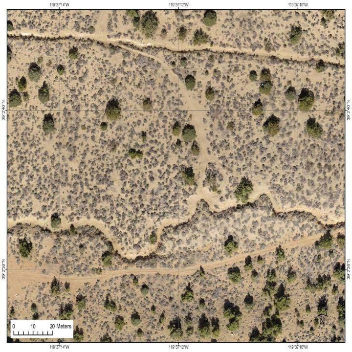
9 UAV Orthoimage
10 WOHNRADE CIVIL TEAMING PARTNERS DroneMapper A Colorado based company specializing in the generation of precision geo-referenced orthomosaics and Digital Elevation Models from aerial images obtained by UAVs and/or manned aircraft DroneDeploy A startup company based in San Francisco that develops UAV mapping applications for agriculture, construction, and mining CAD-1 An Autodesk authorized training center based in Thornton, Colorado Integral Consulting, Inc. An international science and engineering firm providing multidisciplinary services in the fields of health, environment, technology, and sustainability with offices in 13 states.
11 DRILL GREEN 35-ACRE SITE Located in Weld County, Colorado, approximately 4 miles north of Fort Lupton. Currently used for storage of oil and gas equipment Mission Planning and flight execution done manually Digital Elevation Models (DEMs) and Orthomosaics prepared by Drone Mapper using photogrammetry (with 204.jpg images) to survey level accuracy Files are georeferenced using surveyed Ground Control Points (GCP) in Universal Transverse Mercator (UTM) NAD 83 real-world coordinate system DEM s and Orthomosaics are delivered in a.tif file format High and Low resolution Point Clouds are delivered in a.ply file format
12 DEFINITIONS Photogrammetry - The use of photography in surveying and mapping to measure the distance between objects. Hundreds of.jpg images are stitched together to provide a stereoscopic view Ground Control Points (GCPs) - Surveyed points on the surface of the Earth of known locations and elevations, used to geo-reference aerial imagery Geo-reference - The process of associating a physical map or raster image of a map with spatial locations, such as GCPs Ground Sample Distance (GSD) The distance between two consecutive pixel centers, as measured on the ground. The smaller the GSD, the higher the image resolution will be.

13 DRILL GREEN 35-ACRE SITE MISSION PLANNING USING DRONE MAPPER


14 DRILL GREEN 35-ACRE SITE VIEW FLIGHT TRACKS USING GEOSETTER


15 DRILL GREEN 35-AREA SITE VIEW MAPPING RESULTS USING GLOBAL MAPPER

 Create a topographic surface in Civil 3D Use topographic surface for engineering")
16 DRILL GREEN 35-AREA SITE CREATE SURFACE IN CIVIL 3D Edit Point Cloud points from Drone Mapper using the Meshlab program Import the edited Point Cloud into Civil 3D, Ground Sample Distance = 2.6 cm (1.0 ) Create a topographic surface in Civil 3D Use topographic surface for engineering design 9,216,110 point cloud points as compared to 1,112 surveyed points
 in the Denver Metro area Cost =")
, and electronic delivery Delivery Time:")
17 FEES AND DELIVERY TIMES AERIAL PHOTOGRAPHY AND VIDEOGRAPHY Completed projects for JLL (Jones Lang LaSalle) in the Denver Metro area Cost = $800 per site Includes: travel time, flight time, in-house post processing (color correction), and electronic delivery Delivery Time: 3-5 days


18 FEES AND DELIVERY TIMES GEO-REFERENCED AERIAL TOPOGRAPHIC MAPPING Completed 35-acre Drill Green Site UAV Aerial Topography Cost = $3,000, Conventional Survey Cost= $6,000 Includes: travel time, flight time, and surface generation Delivery time: Approximately 4-5 days once ground control points have been established
Aerial Survey of Coffee Estates
 Aerial Survey of Coffee Estates Why get an Aerial Survey of your Coffee Estate done? Aerial surveying produces high resolution and highly accurate image data about your coffee estate. This data can be
AERIAL DATA SERVICES
 AERIAL DATA SERVICES f o r I N D U S T R I A L A P P L I C AT I O N S C O N S T R U C T I O N * A G R I C U L T U R E * E N E R G Y * E N V I R O N M E N T A L A e r o L o g i x C o n s u l t i n g I n
GEOMATICS. Shaping our world. A company of
 GEOMATICS Shaping our world A company of OUR EXPERTISE Geomatics Geomatics plays a mayor role in hydropower, land and water resources, urban development, transport & mobility, renewable energy, and infrastructure
DMS-UAV Accuracy Assessment: AP20 with Nikon D800E
 DMS-UAV Accuracy Assessment: AP20 with Nikon D800E Joe Hutton, Greg Lipa, James Lutes, Omer Mian Applanix, William Chan - GeoPixel Air Introduction The Direct Mapping Solution for Unmanned Aerial Vehicles
The platform is the means, not the end goal
 The platform is the means, not the end goal + Complete analytics platform at an accessible price point Compliments existing workflows by integrating with the new intelligent farm equipment. The goal is
P R O U D LY C A N A D I A N
 P R O U D LY C A N A D I A N 1.855.423.3185 info@rmegeomatics.com AERIAL SURVEYING IMAGING TERRAIN ANALYSIS WHO WE ARE HSE & REGULATORY CLIENT INDUSTRIES RME Geomatics (formerly NGF Geomatics) was founded
Ramani Geosystems. Putting Africa On The Map. Authorized Resellers
 Ramani Geosystems Putting Africa On The Map Authorized Resellers Ramani Profile Started in 1999 Aerial, Land Surveying & Mapping Solutions + 10 Countries in the region + 80 Staff working in projects Asset
The Commercialization of High Resolution Data for Construction, Design and Planning. Nathan Fischer, PE
 The Commercialization of High Resolution Data for Construction, Design and Planning Nathan Fischer, PE 23 Offices across the nation. Woolpert Office Locations: Arlington, VA Atlanta, GA Charleston, SC
QuestUAV DATAhawk PPK Accuracy Assessment and Validation
 QuestUAV DATAhawk PPK Accuracy Assessment and Validation Accuracy of 3.0cm(X), 3.3cm(Y), 3.9cm(Z) Nigel King 1, Kerstin Traut 2, Cameron Weeks 3, Chris Mills 4, Phil Mills 5, Ruairi Hardman 6, Stuart King
Using Remote Piloted Aircraft for Seawall Condition Assessment
 Using Remote Piloted Aircraft for Seawall Condition Assessment Moreton Bay Regional Council Shamim Yazdani Senior Engineer - Stormwater Planning DJI Industries Phantom FC-40 remotely-piloted aircraft 1
Lecture 9: Reference Maps & Aerial Photography
 Lecture 9: Reference Maps & Aerial Photography I. Overview of Reference and Topographic Maps There are two basic types of maps? Reference Maps - General purpose maps & Thematic Maps - maps made for a specific
Web-Based 3D Geospatial Facility Model Data Interfaces
 Web-Based 3D Geospatial Facility Model Interfaces Federal Facilities Council Symposia October 31, 2006 BIM: Grass Root Experiences Alex Viana Naval Facilities Engineering Command Washington Navy Yard,
Global UAV-based solutions for the industry and agriculture.
 Global UAV-based solutions for the industry and agriculture. Remote sensing of vegetation from drones (UAS). The example of the Trimble Unmanned Aerial Solution Emmanuel de Maistre, co-founder & CEO demaistre@redbird.fr
Airborne Multi-Spectral Minefield Survey
 Dirk-Jan de Lange, Eric den Breejen TNO Defence, Security and Safety Oude Waalsdorperweg 63 PO BOX 96864 2509 JG The Hague THE NETHERLANDS Phone +31 70 3740857 delange@fel.tno.nl ABSTRACT The availability
Positional Accuracy of the Google Earth Imagery In The Gaza Strip
 Positional Accuracy of the Google Earth Imagery In The Gaza Strip Maher A. El-Hallaq Associate Professor of Surveying Civil Engineering Department The Islamic University of Gaza, Palestine mhallaq@iugaza.edu.ps
R E D U C E C O S T S A N D E N H A N C E S A F E T Y W I T H U A S S K Y F I R E C O N S U L T I N G. C O M
 PUBLIC SAFETY UAS R E D U C E C O S T S A N D E N H A N C E S A F E T Y W I T H U A S WHY TRUST SKYFIRE? Founded by emergency response professionals, nobody has helped more public safety agencies create
GIS Workshop Data Collection Techniques
 GIS Workshop Data Collection Techniques NOFNEC Conference 2016 Presented by: Matawa First Nations Management Jennifer Duncan and Charlene Wagenaar, Geomatics Technicians, Four Rivers Department QA #: FRG
Scout Aerial Africa DRONES THE BIG PICTURE FOR GEOLOGY AND MINING
 Scout Aerial Africa DRONES THE BIG PICTURE FOR GEOLOGY AND MINING WHO ARE WE? Scout Aerial Group is a diversified operating and investment group with market leading businesses and targeted investment in
T: E:
 PAS 128 UTILITY DETECTION AND MAPPING TOPOGRAPHICAL SURVEYS UTILITY RECORD SEARCHES AND DESK TOP STUDY SURFACE WATER DRAINAGE SURVEYS GROUND CLEARANCE SURVEYS MEASURED BUILDING SURVEYS LASER SCANNING UAV
The AMGI project: A Brief Overview
 The AMGI project: A Brief Overview World Bank Group (Energy & Extractives Global Practice) GEEDR Francisco Igualada (figualada@worldbank.org) Presented by Ash Johnson, Geosoft Inc. The AMGI Project: Vision
GIS = Geographic Information Systems;
 What is GIS GIS = Geographic Information Systems; What Information are we talking about? Information about anything that has a place (e.g. locations of features, address of people) on Earth s surface,
Google Maps and Beyond
 Google Maps and Beyond Aaron Paul First American Title apaul@firstam.com 2015 APRA Symposium Association of Professional Reserve Analysts May 2 nd, 2015 Google Maps and Beyond - Overview Business case
ESRI GIS For Mining Seminar, 10 th August, 2016, Nairobi, Kenya. Spatial DATA Solutions for Mining
 ESRI GIS For Mining Seminar, 10 th August, 2016, Nairobi, Kenya Spatial DATA Solutions for Mining Spatial Data Solutions for Mining Spatial - Data that identifies the geographic location of features &
SURVEYING Chapter 1 Introduction
 PHILADELPHIA UNIVERSITY Faculty of Engineering. Department of Civil Engineering. SURVEYING Chapter 1 Introduction Surveying : the art or science of measuring and representing natural and artificial features
Structure from Motion Photogrammetry for 3D Reconstruction of Crater Glacier on Mount St. Helens, Washington, USA
 Julian Cross GEOG 593 Department of Geography Portland State University 12/5/16 Structure from Motion Photogrammetry for 3D Reconstruction of Crater Glacier on Mount St. Helens, Washington, USA Abstract:
Techniques for Science Teachers: Using GIS in Science Classrooms.
 Techniques for Science Teachers: Using GIS in Science Classrooms. After ESRI, 2008 GIS A Geographic Information System A collection of computer hardware, software, and geographic data used together for
THE USE OF GEOMATICS IN CULTURAL HERITAGE AND ARCHAEOLOGY FOR VARIOUS PURPOSES
 THE USE OF GEOMATICS IN CULTURAL HERITAGE AND ARCHAEOLOGY FOR VARIOUS PURPOSES FEBRUARY 2013 AL BEIDA GEOPLAN CONTENT Company Profile Concept Objectives and Strategies Data Production Methods Data Samples
Cartographic and Geospatial Futures
 Cartographic and Geospatial Futures 1. Web Cartography, WebGIS, & Virtual Globes--New Roles for Maps, GIS, and GIS professionals 2. Map Mashups, the Neo Neo-geography Movement, & Crowd-sourcing Geospatial
An Internet-based Agricultural Land Use Trends Visualization System (AgLuT)
") An Internet-based Agricultural Land Use Trends Visualization System (AgLuT) Prepared for Missouri Department of Natural Resources Missouri Department of Conservation 07-01-2000-12-31-2001 Submitted by
An Internet-based Agricultural Land Use Trends Visualization System (AgLuT) Prepared for Missouri Department of Natural Resources Missouri Department of Conservation 07-01-2000-12-31-2001 Submitted by
Display data in a map-like format so that geographic patterns and interrelationships are visible
 Vilmaliz Rodríguez Guzmán M.S. Student, Department of Geology University of Puerto Rico at Mayagüez Remote Sensing and Geographic Information Systems (GIS) Reference: James B. Campbell. Introduction to
GIS Lecture 5: Spatial Data
 GIS Lecture 5: Spatial Data GIS 1 Outline Vector Data Formats Raster Data Formats Map Projections Coordinate Systems US Census geographic files US Census data files GIS Data Sources GIS 2 Vector Data Formats
Weather Considerations for UAS Integration
 Weather Considerations for UAS Integration Scot Campbell 8 December 2016 Sponsor: Steve Abelman, ANG-C6 DISTRIBUTION STATEMENT A. Approved for public release: distribution unlimited. Legal Notices This
Advanced Technologies in digital 3D-Surface, -Deposit und -Mine- Modelling
 8 th Jordanien International Mining Conference 19.09. to 21.09.2017 Ammann - Jordan Natural Resources: Projected Investment, Reality and Aspirations Dr.-Ing. Marc Dohmen, Aachen Dohmen, Herzog & Partner
DATA SOURCES AND INPUT IN GIS. By Prof. A. Balasubramanian Centre for Advanced Studies in Earth Science, University of Mysore, Mysore
 DATA SOURCES AND INPUT IN GIS By Prof. A. Balasubramanian Centre for Advanced Studies in Earth Science, University of Mysore, Mysore 1 1. GIS stands for 'Geographic Information System'. It is a computer-based
GEO-INFORMATICS AND SPACE TECHNOLOGY FOR PROPERTIES DIGITAL TAX MAP : CASE STUDY ON LOCAL ADMINISTRATIVE WONG KONG MUNICIPALITY, PHITSANULOK, THAILAND
 GEO-INFORMATICS AND SPACE TECHNOLOGY FOR PROPERTIES DIGITAL TAX MAP : CASE STUDY ON LOCAL ADMINISTRATIVE WONG KONG MUNICIPALITY, PHITSANULOK, THAILAND Vicharn Amarakul Regional Center of Geo-Informatics
NCTCOG Regional GIS Meeting 6-Years and Going Strong. May 15, 2018 hosted by: Tarrant County
 NCTCOG Regional GIS Meeting 6-Years and Going Strong May 15, 2018 hosted by: Tarrant County Woolpert at a Glance 1911 Founded in Dayton, Ohio 25+ Offices across the nation 800+ Global employees 25+ OFFICES
Instituting Land Use Controls (LUCs) for Environmental Compliance and Planning
 for Environmental Compliance and Planning") Eleventh Air Force Instituting Land Use Controls (LUCs) for Environmental Compliance and Planning Robert Beachler GeoBase Administrator 611 Civil Engineer Squadron Elmendorf AFB, AK As of: 1 Agenda Introduction
Eleventh Air Force Instituting Land Use Controls (LUCs) for Environmental Compliance and Planning Robert Beachler GeoBase Administrator 611 Civil Engineer Squadron Elmendorf AFB, AK As of: 1 Agenda Introduction
GIS-T 2010 Building a Successful Geospatial Data Sharing Framework: A Ohio DOT Success Story
 GIS-T 2010 Building a Successful Geospatial Data Sharing Framework: A Ohio DOT Success Story ODOT District 2 GIS John Puente District 1 GIS Coordinator\ Planning Administrator 2 Interoperability 3 District
INTEGRATION OF HIGH RESOLUTION QUICKBIRD IMAGES TO GOOGLEEARTH
 INTEGRATION OF HIGH RESOLUTION QUICKBIRD IMAGES TO GOOGLEEARTH M. Alkan a, *, U.G. Sefercik a, M. Oruç a a ZKU, Engineering Faculty, 67100 Zonguldak, Turkey - (mehmetalkan44@yahoo.com) Interactive Sessions,
Preparing the GEOGRAPHY for the 2011 Population Census of South Africa
 Preparing the GEOGRAPHY for the 2011 Population Census of South Africa Sharthi Laldaparsad Statistics South Africa; E-mail: sharthil@statssa.gov.za Abstract: Statistics South Africa (Stats SA) s Geography
Technical Drafting, Geographic Information Systems and Computer- Based Cartography
 Technical Drafting, Geographic Information Systems and Computer- Based Cartography Project-Specific and Regional Resource Mapping Services Geographic Information Systems - Spatial Analysis Terrestrial
Esri Image & Mapping Forum 9 July 2017 Geiger-Mode for Conservation Planning & Design by USDA NRCS NGCE
 Esri Image & Mapping Forum 9 July 2017 Geiger-Mode for Conservation Planning & Design by USDA NRCS NGCE For over 75 years, the Natural Resources Conservation Service has been a pioneer in conservation,
State-of-the-Art GIS as an Integrating Technology
 Paper # 104: GIS for Oil Spill Prevention & Response Devon Humphrey Instructor, National Spill Control School Texas A&M University at Corpus Christi, TX Introduction and History The National Spill Control
Cutting Edge Engineering for Modern Geospatial Systems Rear Admiral Dr. S Kulshrestha, retd
 Cutting Edge Engineering for Modern Geospatial Systems Rear Admiral Dr. S Kulshrestha, retd 11 Jun 2015 GeoIntelligence Asia 2015 The technology would become so pervasive that it becomes a part of you
Write a report (6-7 pages, double space) on some examples of Internet Applications. You can choose only ONE of the following application areas:
 on some examples of Internet Applications. You can choose only ONE of the following application areas:") UPR 6905 Internet GIS Homework 1 Yong Hong Guo September 9, 2008 Write a report (6-7 pages, double space) on some examples of Internet Applications. You can choose only ONE of the following application
UPR 6905 Internet GIS Homework 1 Yong Hong Guo September 9, 2008 Write a report (6-7 pages, double space) on some examples of Internet Applications. You can choose only ONE of the following application
When Map Quality Matters
 When Map Quality Matters 50% 25% Powerful geospatial mapping tools for Adobe Creative Cloud and offline map solutions for mobile devices 20% When Map Quality Matters 10% We re focused on creating powerful
Emergency Planning. for the. Democratic National. Convention. imaging notes // Spring 2009 //
 Emergency Planning for the Democratic National Convention The DRAPP Demonstrates Partnership among Local, Regional, State, Utility and Federal Governments 14 imaging notes // Spring 2009 // www.imagingnotes.com
SPOT DEM Product Description
 SPOT DEM Product Description Version 1.1 - May 1 st, 2004 This edition supersedes previous versions Acronyms DIMAP DTED DXF HRS JPEG, JPG DEM SRTM SVG Tiff - GeoTiff XML Digital Image MAP encapsulation
June 19 Huntsville, Alabama 1
 June 19 Huntsville, Alabama 1 Real-Time Geospatial Data: The Fusion of PI and ArcGIS Enabling Smarter Facilities Management OSIsoft and Esri Mapping and Location Analytics Platform Supporting Your Use
QuestUAV British UAV Manufacturer
 QuestUAV British UAV Manufacturer Aircraft designed to carry sensors such as high resolution cameras infra red cameras thermal and video cameras multiple payloads QuestUAV have been operating for five
GIS Resources for Local Governments
 ISSUE PAPER SERIES GIS Resources for Local Governments February 2018 NEW YORK STATE TUG HILL COMMISSION DULLES STATE OFFICE BUILDING 317 WASHINGTON STREET WATERTOWN, NY 13601 (315) 785-2380 WWW.TUGHILL.ORG
Features and Benefits
 Autodesk LandXplorer Features and Benefits Use the Autodesk LandXplorer software family to help improve decision making, lower costs, view and share changes, and avoid the expense of creating physical
NJ SURVEYORS CONFERENCE
 NJ SURVEYORS CONFERENCE PART 107 Ground School TODAY S AGENDA Regulations National Airspace System Operations Weather Loading and Performance 1 REGULATIONS Remote Pilot Certifications and Privileges When
DRAPE 2014 Digital Elevation Model
 DRAPE 2014 Digital Elevation Model User Guide Spatial Data Infrastructure Mapping and Information Resources Branch Corporate Management and Information Division Ministry of Natural Resources and Forestry
GEOMATICS SURVEYING AND MAPPING EXPERTS FOR OVER 35 YEARS
 GEOMATICS SURVEYING AND MAPPING EXPERTS FOR OVER 35 YEARS 2 GEOMATICS AND SURVEYING SOLUTIONS SPANNING THE ENTIRE PROJECT LIFECYCLE 1,000+ 250+ 24 Surveying professionals Active field crews Geomatics offices
VISUALIZING THE SMART CITY 3D SPATIAL INFRASTRUCTURE GEOSMART ASIA- 30 SEP, 2015
 www.aamgroup.com VISUALIZING THE SMART CITY 3D SPATIAL INFRASTRUCTURE GEOSMART ASIA- 30 SEP, 2015 Agenda AAM What is a Smart City? Data Acquisition 3D Modelling Benefits Questions AAM AAM is a Geospatial
COMPANY PROFILE. For PHOTOGRAMMETRY, LiDAR, BIM, UAV, GIS and SURVEYING SOLUTIONS. Submitted by MARVEL GEOSPATIAL SOLUTIONS PVT.LTD.
 COMPANY PROFILE For PHOTOGRAMMETRY, LiDAR, BIM, UAV, GIS and SURVEYING SOLUTIONS Submitted by MARVEL GEOSPATIAL SOLUTIONS PVT.LTD. Table of Contents 1. ABOUT US... 3 1.1 MISSION/VISION... 4 2. SERVICES
Geographic Information Systems. Introduction to Data and Data Sources
 Geographic Information Systems Introduction to Data and Data Sources Presented by John Showler, NJDA-SSCC NJ SCD GIS Training Session December 10, 209 The Objectives of this session are 3-fold: 1. Introduce
Content. 1. Introduction. 2. Strengthening Unified Supervision of Surveying and Mapping. 3. Geospatial Information Resources and Utilization
 1. Introduction Content 2. Strengthening Unified Supervision of Surveying and Mapping 3. Geospatial Information Resources and Utilization 4. Current Situation of the Geospatial Industry 5. Opportunities
9/24/2014. Georeferencing: conclusions
 Georeferencing: conclusions 1 GEOG 300: UTM REVIEW QUIZ (0%) 1. The UTM system is composed of zones, each degrees longitude wide 2. The 0 value for northings is located at 3. The 0 value for eastings is
Bentley Map Advancing GIS for the World s Infrastructure
 Bentley Map Advancing GIS for the World s Infrastructure Presentation Overview Why would you need Bentley Map? What is Bentley Map? Where is Bentley Map Used? Red text signifies new things in Bentley Map
Developing a Campus-wide Base Map for Planning, Design and Construction. June 21, 2007
 Developing a Campus-wide Base Map for Planning, Design and Construction June 21, 2007 Presenters Berent Pippert UCR Project Manager Capital and Physical Planning Academic Planning and Budget 951-827-2431
Yrd. Doç. Dr. Saygın ABDİKAN Öğretim Yılı Güz Dönemi
 Yabancı Dil III (YDL285) Introduction to Geomatics Yrd. Doç. Dr. Saygın ABDİKAN 2017-2018 Öğretim Yılı Güz Dönemi 1 géomatique Geo (Earth) + informatics Geodesy + Geoinformatics Geomatics: The mathematics
Country Report on SDI Activities in Singapore *
 UNITED NATIONS E/CONF.100/CRP.9 ECONOMIC AND SOCIAL COUNCIL Eighteenth United Nations Regional Cartographic Conference for Asia and the Pacific Bangkok, 26-29 October 2009 Item 7(a) of the provisional
HKND Group Ltd Grand Canal Project
 HKND Group Ltd Grand Canal Project General Overview of Aerial Survey Project Managua, Nicaragua September 21 st 2015 Presented by: Jeff Elliott Managing Director CSA Global About CSA Global CSA Global
uas.usgs.gov John Fulton & Jeff Sloan USGS Denver, Colorado USA August 2016
 Department of the Interior USGS National Unmanned Aircraft Systems Project Office uas.usgs.gov John Fulton & Jeff Sloan USGS Denver, Colorado USA August 2016 1 UAS Basics Sources of Remote Sensing Data
Aerial Photography and Imagery Resources Guide
 Aerial Photography and Imagery Resources Guide Cheyenne and Laramie County Cooperative GIS Created and Maintained by the GIS Coordinator for the Cooperative GIS Program March 2011 CHEYENNE / LARAMIE COUNTY
Creating an On Target Geospatial Foundation for the Navajo Housing Authority
 Creating an On Target Geospatial Foundation for the Navajo Housing Authority 2012 Geospatial Excellence Awards MAPPS 2012 Geospatial Products and Services Excellence Awards 2012 Awards Entry Form Please
SUPPORTS SUSTAINABLE GROWTH
 DDSS BBUUN NDDLLEE G E O S P AT I A L G O V E R N A N C E P A C K A G E SUPPORTS SUSTAINABLE GROWTH www.digitalglobe.com BRISBANE, AUSTRALIA WORLDVIEW-3 30 CM International Civil Government Programs US
Satellite Imagery: A Crucial Resource in Stormwater Billing
 Satellite Imagery: A Crucial Resource in Stormwater Billing May 10, 2007 Carl Stearns Engineering Technician Department of Public Works Stormwater Services Division Sean McKnight GIS Coordinator Department
An Industry Perspective. Bryn Fosburgh Vice President Trimble
 An Industry Perspective Bryn Fosburgh Vice President Trimble Who are we? Professionals & Consultants Geospatial Professionals working at or with: AEC Consultants Transportation Departments Construction
The Use of Higher-Resolution Satellite Imagery, LiDAR and Drones in River Applications:
 The Use of Higher-Resolution Satellite Imagery, LiDAR and Drones in River Applications: Meander Belt Width Assessments to Effluent Plume Delineation Joanna Eyquem, P.Geo., Principal Fluvial Geomorphology,
Geospatial SDI Portal for effective Governance of Pune METROPOLIS region
 Geospatial SDI Portal for effective Governance of Pune METROPOLIS region Mr. Praveen Gautam Senior Manager 19 th January 2018 PMRDA Overview Provide a Spatial Framework for the entire region with various
NAVAJO NATION PROFILE
 NAVAJO NATION PROFILE Largest land based area and federally recognized tribe in the United States Over 27,000 square miles (or 17.2 million acres with a population of over 300,000 people. Covers Arizona,
Geospatial Data Standards Considerations for the delivery of 2D and 3D spatial data February 2019
 Geospatial Data Standards Considerations for the delivery of 2D and 3D spatial data February 2019 Prepared by: GRCA Geomatics Version Date Summary of Changes Changes Made By: 1.00 March 16, 2018 Version
Chris Doerr Phone: Aircraft Cost Calculator, LLC 1341 W. Mequon Road, Suite 205, Mequon, WI Powered by ACC:
 Annual & Hourly Cost Detail Embraer Legacy 650 GENERAL PARAMETERS Min Crew / Max Passengers 2 / 13 Seats Full Range (NM / SM) 3569.48 / 4107.68 Normal Cruise Speed (KTS / MPH) 435.83 / 501.54 Average Pre-Owned
Remote sensing supported surveillance of tailings dams and impoundments: case Laiva mine
 Remote sensing supported surveillance of tailings dams and impoundments: case Laiva mine Anssi Rauhala, Anne Tuomela, Pekka M. Rossi Water Resources and Environmental Engineering, University of Oulu, Finland,
GIS for ChEs Introduction to Geographic Information Systems
 GIS for ChEs Introduction to Geographic Information Systems AIChE Webinar John Cirucci 1 GIS for ChEs Introduction to Geographic Information Systems What is GIS? Tools and Methods Applications Examples
Unmanned Aerial Systems (UAS) Innovation for affordable, improved and accelerated spatial data acquisition
 Innovation for affordable, improved and accelerated spatial data acquisition") Unmanned Aerial Systems (UAS) Innovation for affordable, improved and accelerated spatial data acquisition Kathrine Kelm, The World Bank Rumyana Tonchovska, FAO Walter Volkmann, Micro Aerial Projects,
Unmanned Aerial Systems (UAS) Innovation for affordable, improved and accelerated spatial data acquisition Kathrine Kelm, The World Bank Rumyana Tonchovska, FAO Walter Volkmann, Micro Aerial Projects,
Annual & Hourly Cost Detail
 Aircraft Analysis Annual & Hourly Cost Detail Embraer Phenom 100 GENERAL PARAMETERS Min Crew / Max Passengers 1 / 6 Seats Full Range (NM / SM) 896.00 / 1031.10 Normal Cruise Speed (KTS / MPH) 390.00 /
Using MAGIC to Access Spatial Imagery: Putting ER Mapper Image Web Server, ArcIMS and MrSID to work in your Library
 Using MAGIC to Access Spatial Imagery: Putting ER Mapper Image Web Server, ArcIMS and MrSID to work in your Library Patrick McGlamery Shirley Quintero University of Connecticut Libraries Building the Connecticut
Data Aggregation with InfraWorks and ArcGIS for Visualization, Analysis, and Planning
 Data Aggregation with InfraWorks and ArcGIS for Visualization, Analysis, and Planning Stephen Brockwell President, Brockwell IT Consulting, Inc. Join the conversation #AU2017 KEYWORD Class Summary Silos
GEOGRAPHIC INFORMATION SYSTEMS
 GEOGRAPHIC INFORMATION SYSTEMS 4-H Round-Up Community Transitions Workshop Daniel Hanselka June 14, 2011 Goals of the Workshop Answer the question: What is GIS? Uses of GIS. Some of the Common Terminology
Flood Mapping Michael Durnin October 9 th
 Michael Durnin October 9 th 2014 Leading Surveyors Company Profile Est. 1983 Celebrating 30 Years in Business Six Offices in UK & Ireland Over 30 Specialised Survey Services ISO 9001:2008 Registered Over
Geospatial Data, Services, and Products. National Surveying, mapping and geospatial conference
 Geospatial Data, Services, and Products Federal Programs -- USDA NRCS National Surveying, mapping and geospatial conference March 15, 2016 NRCS Applications using Geosaptial Products & Services Field
12/26/2012. Geographic Information Systems * * * * GIS (... yrezaei
 ( - Geographic Information Systems ( ( 1 2 3 Information System Data base DB IS IS DB (Knowledge ( ( (System (Information System - (Georefrence Analysis Data + Knowledge ======== Information 4 5 ( < 10%
The National Spatial Data Infrastructure of Zambia Shlomi SIVAN, Israel. Key words: National Land Audit, GIS, LIS, Common Spatial Data
 The National Spatial Data Infrastructure of Zambia Shlomi SIVAN, Israel Key words: National Land Audit, GIS, LIS, Common Spatial Data SUMMARY One of Zambia's important challenges is to recognize the title
To: Ross Martin, Lisa Stapleton From: Brad Lind Subject: Joint Funding Agreement with USGS for 2012 Imagery Date: March 14, 2012.
 To: Ross Martin, Lisa Stapleton From: Brad Lind Subject: Joint Funding Agreement with USGS for 2012 Imagery Date: March 14, 2012 Attached are two copies of the Joint Funding Agreement (JFA) between SanGIS
COURSE SCHEDULE, GRADING, and READINGS
 COURSE SCHEDULE, GRADING, and READINGS Note: All academic classes will be held in the GIS lab at Royal Thimphu College. These dates are listed here. Other days will involve travel or days off, and the
Export Basemap Imagery from GIS to CAD
 Export Basemap Imagery from GIS to CAD This tutorial illustrates how to add high resolution imagery as a basemap into an existing CAD drawing using ArcGIS and AutoCAD. Through this method, the imagery
Introduction-Overview. Why use a GIS? What can a GIS do? Spatial (coordinate) data model Relational (tabular) data model
 data model Relational (tabular) data model") Introduction-Overview Why use a GIS? What can a GIS do? How does a GIS work? GIS definitions Spatial (coordinate) data model Relational (tabular) data model intro_gis.ppt 1 Why use a GIS? An extension
Introduction-Overview Why use a GIS? What can a GIS do? How does a GIS work? GIS definitions Spatial (coordinate) data model Relational (tabular) data model intro_gis.ppt 1 Why use a GIS? An extension
INSAR DEM CALIBRATION FOR TOPOGRAPHIC MAPPING IN EASTERN UGANDA
 INSAR DEM CALIBRATION FOR TOPOGRAPHIC MAPPING IN EASTERN UGANDA Siefko SLOB *, François KERVYN **, Johan LAVREAU **, John ODIDA *** and David KYAGULANYI *** * International Institute for Aerospace Survey
Advanced Algorithms for Geographic Information Systems CPSC 695
 Advanced Algorithms for Geographic Information Systems CPSC 695 Think about Geography What is Geography The 3 W s of Geography What is where Why is it there Why do I care Data - Data - Data We all got
The National Geospatial Technology Center of Excellence and a look at the future of Geospatial Technology
 The National Geospatial Technology Center of Excellence and a look at the future of Geospatial Technology Vincent A. DiNoto, Jr. Director of GeoTech Center Vince.dinoto@kctcs.edu Based upon work supported
Aerial Photography and Imagery Resources Guide
 Aerial Photography and Imagery Resources Guide Cheyenne and Laramie County Cooperative GIS Created and Maintained by the GIS Coordinator for the Cooperative GIS Program May 2016 CHEYENNE / LARAMIE COUNTY
Field Verification of Gas Pipeline HCA s. John Linehan, GISP Enbridge Energy Company (US) Houston, TX 24 Feb 2009
 Houston, TX 24 Feb 2009") Field Verification of Gas Pipeline HCA s John Linehan, GISP Enbridge Energy Company (US) Houston, TX 24 Feb 2009 Purpose According to 49 CFR 192.905(c), a gas transmission must incorporate an HCA into
Field Verification of Gas Pipeline HCA s John Linehan, GISP Enbridge Energy Company (US) Houston, TX 24 Feb 2009 Purpose According to 49 CFR 192.905(c), a gas transmission must incorporate an HCA into
USING GIS CARTOGRAPHIC MODELING TO ANALYSIS SPATIAL DISTRIBUTION OF LANDSLIDE SENSITIVE AREAS IN YANGMINGSHAN NATIONAL PARK, TAIWAN
 CO-145 USING GIS CARTOGRAPHIC MODELING TO ANALYSIS SPATIAL DISTRIBUTION OF LANDSLIDE SENSITIVE AREAS IN YANGMINGSHAN NATIONAL PARK, TAIWAN DING Y.C. Chinese Culture University., TAIPEI, TAIWAN, PROVINCE
Indiana GIS Resources
 Indiana GIS Resources National Association of Water Companies September 21, 2017 Jim Sparks Indiana Geographic Information Officer ABOUT THE INDIANA GEOGRAPHIC INFORMATION OFFICE I.C. 4-23-7.3 Indiana
SOLUTIONS ADVANCED GIS. TekMindz are developing innovative solutions that integrate geographic information with niche business applications.
 ADVANCED GIS SOLUTIONS TekMindz are developing innovative solutions that integrate geographic information with niche business applications. TEK INDZ TM GIS Services Overview At the leading edge of geospatial
Using UAS Technology to Obtain Aerial Storm Damage Imagery. -Mike Sporer NWS Blacksburg
 Using UAS Technology to Obtain Aerial Storm Damage Imagery -Mike Sporer NWS Blacksburg The National Weather Service routinely conducts damage surveys following severe weather events. Observed damage indicators