The Pace of Change Is Accelerating Creating Many Challenges
|
|
|
- Brook Patterson
- 5 years ago
- Views:
Transcription
1
2 VISION


3 The Pace of Change Is Accelerating Creating Many Challenges Evidence Threatening Our Natural World and Our Future as Humans Social Conflict Mass Migration Ocean Acidification Food Population Urbanization Water We Are Now at a Place Where No Humans Have Been... Deforestation Pollution Drought Political Polarization Loss of Biodiversity Climate Change Energy We Need More Understanding... Collaboration and... Action

4 What Should We Do Next? Apply the Power of Digital Geography Protect Biodiversity Envision What s Possible Improve Productivity and Efficiency Create Sustainable Development Engage Citizens Make Cities Smarter Integrate Environmental Thinking Design with Nature Keep Moving, Learning, and Understanding... Leverage Our Best Technology, Geographic Science, and Holistic Design Thinking


5 GIS Is Advancing Rapidly Integrating and Leveraging Many Innovations Web GIS Easier, Open, and Accessible GIS Innovation Data Real-Time Exploration Scripting Apps 3D Visualization Imagery Smart Mapping Geospatial AI Predictive Analytics Modeling Distributed Architecture Content Expanding the Power of GIS


6 Web GIS Is the Modern GIS Architecture Helping Everyone Do Their Work Better Leveraging Web Services Teams Organizations Departments Communities Distributed... and Interconnected Engaging Everyone Individuals Sharing and Collaboration
7 Web Maps Engage and Interconnect... Everyone Providing a Common Language Supporting Communication and Real-Time Awareness People Organizations Communities A Common Framework... for Collaborating and Problem Solving


8 Nick s Top Five UC Themes

9 Autodesk & Esri Partnership


10 Autodesk and ArcGIS Providing Direct Product Integration and Interoperability Design & Engineering ArcGIS Pro AutoCAD Revit Direct Read GIS ArcGIS InfraWorks... Integrating Design and Planning Workflows
11 Apps, Apps, and more Apps


12 Apps Take The Science of Where... Everywhere Making Your Work Widely Available Taking GIS to the Edge Dashboards Story Maps Field Apps Web Apps


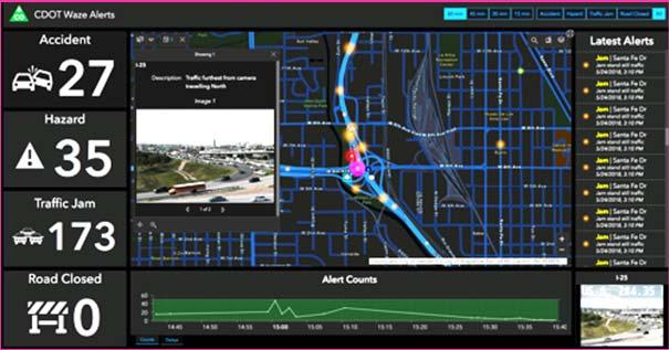
13 Operations Dashboard Dynamic Visual Reporting & Analytics Totally New App Accidents Web Based Improved Performance Easy Configuration Easily Embedded New Widgets Online or Enterprise Any Data Feed Crime Wildfire


14 Field Solutions Empowering Mobile Workers Workforce Navigator Survey123 Collector Explorer Collecting Data Coordinating Work Navigation Smart Forms G Digital Map Book Mapping & Markup Tracking Connected and Disconnected Tracker Real-Time Dashboard


15 ArcGIS Pro Professional GIS Coming ArcMap ArcGIS Pro New Innovations Apps Improvements Utility Management Improved Catalog Metadata Pop Ups Batch Geoprocessing New 3D Multipatch Editing Attribute Rules Full-Motion Video Streaming Layers UTM Zone Clipping Revit Integration Artificial Intelligence Parcel Management Dimensions Reports Publish to Server Offset Printing 3D Interpolation Unstructured Data Voxels Ongoing Support Pause Drawing Advanced Mapping, Visualization, Editing, and Analysis ArcGIS Pro A Comprehensive Desktop GIS


16 ArcGIS Pro Roadmap Near term Attribute Rule enhancements Dimensions Contingent Values Building Scene Layer Reports Offset Printing Extract Locations from Text Dynamic Feature Binning and Clustering Mobile Scene Package 3D Interpolation Voxel Scene layer Parallel desktop processing using Spark Deep Learning for Images Mid term Parcel Management Projects in the Enterprise Scatter plot matrix Layer blend modes Presentations Animated Symbols Materials 3D Effects GPS Support Terrain Editing Trend Profile Chart 3D Mesh as ground Extensions Long term Physically based rendering Geoprocessing in the database July 2018
17 Focused Solutions


18 ArcGIS Hub Is Transforming Community Engagement and Collaboration Organizing and Leveraging Stakeholder Interactions Initiatives Open Data Policy Initiatives Initiative Framework Open Data Community Portals Apps Story Maps Identities Stakeholders Community Portal Performance Reporting Performance Dashboards Government Leaders Community Leaders Universities NGOs Citizens Urban Planning Demographic Reporting Enabling Civic Participation


 Extensive")


19 ArcGIS Solutions Industry-Specific Apps, Maps, and Tools... Extending Your GIS Solution Components Solution Configurations New Popular (500K Downloads) Extensive (450+) Open Source Fully Supported Apps Data Models Widgets Tools Maps Workflows Add-Ins Dashboards Technology Workflows Implementation Training Support Rapidly Delivering Value Implemented by Users, Partners, and Esri


20 ArcGIS Indoors Assemble, Manage, and Share Indoor Information New Portfolio Management Buildings Infrastructure Operations Safety & Security Emergency Management System of Record 3D Maps Wayfinding Employee Routing Public Kiosk Asset Management BIM Integration Real-Time Tracking Problem Reporting Dashboards Wayfinding Floor Plans Stakeholders Business Owners Operators Employees Visitors Complete Indoor Mapping and Location System


21 ArcGIS Urban Will Revolutionize City Planning and Design New Projects Buildings Infrastructure Immersive and Collaborative Plans Zoning Land Use Transportation Track and Evaluate Projects Create Planning Scenarios Stakeholders Government Digital Twin Indicators Urban Performance Suitability Impact Evaluations Report and Engage Architects Developers Citizens Transforming the Process of Urban Development...
22 Artificial Intelligence & Machine Learning


23 Artificial Intelligence & Machine Learning ArcGIS Includes ML and Integrates AI New and Improved AI Clustering Prediction Classification Regression Interpolation Object Identification Coming Feature Extraction Site Selection Event Prediction Image Analysis Density-Based Clustering ArcGIS Empirical Bayesian Kriging Regression Prediction Python Integration Accident Prediction CNTK TensorFlow scikit-learn Microsoft IBM Watson Amazon Feature Extraction Feature Identification Forest-Based Classification and Regression Training Data Preparation Machine Learning Geoprocessing Tools Property Condition Survey
24 WebGIS Advancements


25 ArcGIS Online Complete Mapping and Location Intelligence Platform New and Improved Coming Pro Apps APIs Content Easier Search Smart Mapping (2D/3D) Analytics Web Apps Galleries Authoritative Content External Cloud Access Map Viewer Update Intelligent Search Imagery Management IoT Integration Cross-Organization Collaboration Administration FedRAMP Authorized 5.8+ M Users 1+ B/Day Maps Mapping, Analysis, and Field Mobility 17+ M Items 59+ M Open Data Downloads


 Easier Install and")
26 ArcGIS Enterprise Comprehensive GIS for Your Organization Coming New New and Improved Containerization Desktop ArcGIS Enterprise Apps APIs Sites User Experience Performance Resilience Big Data Analytics Distributed Collaboration Microsite Builder (Sites) ArcGIS Monitor Intelligent Search Machine Learning & Predictive Analytics Hosted Python Notebooks Integrated DevOps Tools Deployable On-Premises and in the Cloud Level 1 Users (Free in Enterprise) Easier Install and Deployment Enterprise Data Management, Analysis, and Mapping


27 Insights Location Analytics and Visualization Visual, Intuitive & Interactive Spatial and Tabular Analysis Many Data Types Charts and Maps Link Analysis Repeat Analysis New and Improved Spreadsheets Databases GIS Data Regression Linked & Responsive Cards Link Analysis Statistical Analysis Dynamic Binning Symbology Charting Tabular Tools Part of ArcGIS Online & Enterprise Data Integration Enabling Exploratory Analysis for Everyone
28 ArcGIS Enables Distributed Collaboration Automatically Replicating Maps, Apps, and Related Content Replicate ArcGIS Online Foundation for System of Systems Portal ArcGIS Enterprise Distributed Servers Supporting Dynamic Sharing and Synchronization Within Organizations and Beyond


29 Common use patterns for Distributed Collaboration One to One: Between many:
30 Autodesk Partnership Apps Focused Solutions AI & Machine Learning WebGIS Advancements
31 Esri Gulf-Coast User Conference October New Orleans Links: Gulf-Coast UC UC Plenary Videos UC Technical Videos (50 videos)


32 Brad Owens ArcGIS Enterprise Sites


33
LEARNING CREATING RELATIONSHIPS UNDERSTANDING INSPIRING SHARING CONNECTING FUN PURPOSE
 WELCOME LEARNING CREATING RELATIONSHIPS UNDERSTANDING CONNECTING INSPIRING FUN SHARING PURPOSE VISION VISION WE LIVE In a Complex...... and Interconnected World Human Resources Energy Networks Communications
ArcGIS for INSPIRE. Marten Hogeweg Satish Sankaran
 ArcGIS for INSPIRE Marten Hogeweg Satish Sankaran Outline What is ArcGIS ArcGIS for INSPIRE Web GIS Case Studies Roadmap Q&A What is INSPIRE? INSPIRE is the legal framework for a European Spatial Data
ArcGIS is Advancing. Both Contributing and Integrating many new Innovations. IoT. Smart Mapping. Smart Devices Advanced Analytics
 ArcGIS is Advancing IoT Smart Devices Advanced Analytics Smart Mapping Real-Time Faster Computing Web Services Crowdsourcing Sensor Networks Both Contributing and Integrating many new Innovations ArcGIS
A Vision for ArcGIS Applying Geography Everywhere
 A Vision for ArcGIS Applying Geography Everywhere WELCOME PURPOSE A Network of GIS Professionals Are Awakening the World to the Power of Web GIS You Your WORK Making a Difference Your Work Open Maps and
Smart Land Administration. Brent A. Jones, PE, PLS
 Smart Land Administration Brent A. Jones, PE, PLS bjones@esri.com What is Smart? Required Important Modern Open Secure Authoritative Sustainable Cost Effective Reliable Scalable Contributory Usable Timely
OFWIM 2017 Annual Conference What Does Web GIS Really Mean for Fish and Wildlife Agencies?
 Content Open Mapping OFWIM 2017 Annual Conference What Does Web GIS Really Mean for Fish and Wildlife Agencies? Imagery Spatial Analysis Mike Bialousz, Esri 3D Data Exploration Real-Time Apps Visualization
You are Building Your Organization s Geographic Knowledge
 You are Building Your Organization s Geographic Knowledge And Increasingly Making it Available Sharing Data Publishing Maps and Geo-Apps Developing Collaborative Approaches Citizens Knowledge Workers Analysts
ArcGIS. for Server. Understanding our World
 ArcGIS for Server Understanding our World ArcGIS for Server Create, Distribute, and Manage GIS Services You can use ArcGIS for Server to create services from your mapping and geographic information system
Esri User Conference 2018 Video Topics
 Esri User Conference 2018 Video Topics 3D GIS 3D Across ArcGIS 3D Analysis Tools in ArcGIS Pro 3D Cartographic Techniques: An Introduction 3D Data: Lidar Point Clouds and 3D Mesh 3D Feature and Sub-Surface
Welcome. C o n n e c t i n g
 Welcome C o n n e c t i n g YOU D i s c i p l i n e s Why is This Meeting......So Important Now? OUR WORLD Is Increasingly Challenged The Evidence Is Clear We Need Better Understanding and More Collaboration
ArcGIS Enterprise: What s New. Philip Heede Shannon Kalisky Melanie Summers Sam Williamson
 ArcGIS Enterprise: What s New Philip Heede Shannon Kalisky Melanie Summers Sam Williamson ArcGIS Enterprise is the new name for ArcGIS for Server What is ArcGIS Enterprise ArcGIS Enterprise is powerful
Esri and GIS Education
 Esri and GIS Education Organizations Esri Users 1,200 National Government Agencies 11,500 States & Regional Agencies 30,800 Cities & Local Governments 32,000 Businesses 8,500 Utilities 12,600 NGOs 11,000
Demystifying ArcGIS Online. Karen Lizcano Esri
 Demystifying ArcGIS Online Karen Lizcano Esri An Integrated Web GIS Platform Desktop Web Device Powered by Services Managed via Portal Access from any Device Portal Server Online Content and Services ArcGIS
Leveraging Web GIS: An Introduction to the ArcGIS portal
 Leveraging Web GIS: An Introduction to the ArcGIS portal Derek Law Product Management DLaw@esri.com Agenda Web GIS pattern Product overview Installation and deployment Configuration options Security options
Spatial Analysis with Web GIS. Rachel Weeden
 Spatial Analysis with Web GIS Rachel Weeden Agenda Subhead goes here Introducing ArcGIS Online Spatial Analysis Workflows Scenarios Other Options Resources ArcGIS is a Platform Making mapping and analytics
Esri WebGIS Highlights of What s New, and the Road Ahead
 West Virginia GIS Conference WVU, Morgantown, WV Esri WebGIS Highlights of What s New, and the Road Ahead Mark Scott, Solutions Engineer, Esri Local Government Team May 5 th, 2016 West Virginia GIS Conference
Introduction to Portal for ArcGIS
 Introduction to Portal for ArcGIS Derek Law Product Management March 10 th, 2015 Esri Developer Summit 2015 Agenda Web GIS pattern Product overview Installation and deployment Security and groups Configuration
ArcGIS Urban: An Introduction. Lisa Staehli ArcGIS Urban Team Product Development Brooks Patrick ArcGIS Urban Team Business Development
 ArcGIS Urban: An Introduction Lisa Staehli ArcGIS Urban Team Product Development Brooks Patrick ArcGIS Urban Team Business Development Our Cities Are Facing Massive Challenges Our Cities Are Facing Massive
Web GIS: Architectural Patterns and Practices. Shannon Kalisky Philip Heede
 Web GIS: Architectural Patterns and Practices Shannon Kalisky Philip Heede Web GIS Transformation of the ArcGIS Platform Desktop Apps Server GIS Web Maps Web Scenes Layers Web GIS Transformation of the
ArcGIS Pro Q&A Session. NWGIS Conference, October 11, 2017 With John Sharrard, Esri GIS Solutions Engineer
 ArcGIS Pro Q&A Session NWGIS Conference, October 11, 2017 With John Sharrard, Esri GIS Solutions Engineer jsharrard@esri.com ArcGIS Desktop The applications ArcGIS Pro ArcMap ArcCatalog ArcScene ArcGlobe
Portal for ArcGIS: An Introduction. Catherine Hynes and Derek Law
 Portal for ArcGIS: An Introduction Catherine Hynes and Derek Law Agenda Web GIS pattern Product overview Installation and deployment Configuration options Security options and groups Portal for ArcGIS
June 19 Huntsville, Alabama 1
 June 19 Huntsville, Alabama 1 Real-Time Geospatial Data: The Fusion of PI and ArcGIS Enabling Smarter Facilities Management OSIsoft and Esri Mapping and Location Analytics Platform Supporting Your Use
The Platform Generation. Derek Law and Ebony Wicks
 The Platform Generation Derek Law and Ebony Wicks GIS Provides the Framework and Process For Applying Geography Analysis and Interpretation Design and Planning Creating Understanding Modeling and Predicting
Incorporating ArcGIS Pro in your Curriculum
 AAG, Boston 2017 April 5, 2017 Incorporating ArcGIS Pro in your Curriculum Geri Miller Agenda Concerns Acknowledged Learning curve ArcGIS Pro does not have all the tools (perception) Licensing and offline
What Would John Snow Do (Today)? Part 1
? Part 1") What Would John Snow Do (Today)? Part 1 Tanya Bigos and Derek Law @Tanyabigos @GIS_Bandit Thurs Oct 19 th, 2017 Outline Overview of the ArcGIS Platform Whiteboard discussion Summary Questions A Whole New
What Would John Snow Do (Today)? Part 1 Tanya Bigos and Derek Law @Tanyabigos @GIS_Bandit Thurs Oct 19 th, 2017 Outline Overview of the ArcGIS Platform Whiteboard discussion Summary Questions A Whole New
Esri Overview for Mentor Protégé Program:
 Agenda Passionate About Helping You Succeed Esri Overview for Mentor Protégé Program: Northrop Grumman CSSS Jeff Dawley 3 September 2010 Esri Overview ArcGIS as a System ArcGIS 10 - Map Production - Mobile
Geography for the 2020 Round of Census
 Boundaries Key Census Data EA Id Population Male Female EA Id Area EA Id Num HH Avg HH size Geography for the 2020 Round of Census Linda Peters, Esri lpeters@esri.com Integration of Statistical and Geospatial
Introduction to ArcGIS Maps for Office. Greg Ponto Scott Ball
 Introduction to ArcGIS Maps for Office Greg Ponto Scott Ball Agenda What is Maps for Office? Platform overview What are Apps for the Office? ArcGIS Maps for Office features - Visualization - Geoenrichment
Web GIS & ArcGIS Pro. Zena Pelletier Nick Popovich
 Web GIS & ArcGIS Pro Zena Pelletier Nick Popovich Web GIS Transformation of the ArcGIS Platform Desktop Apps GIS Web Maps Web Scenes Layers Evolution of the modern GIS Desktop GIS (standalone GIS) GIS
Introduction to Portal for ArcGIS. Hao LEE November 12, 2015
 Introduction to Portal for ArcGIS Hao LEE November 12, 2015 Agenda Web GIS pattern Product overview Installation and deployment Security and groups Configuration options Portal for ArcGIS + ArcGIS for
Changes in Esri GIS, practical ways to be ready for the future
 Changes in Esri GIS, practical ways to be ready for the future John Sharrard, Esri April 16, 2015 The only thing that is constant is change. Heraclitus, ca. 500 B.C. My story (of experiencing change) Changes
Strategies for Integrating CAD and BIM in ArcGIS. Don Kuehne Esri 3D Product Manager: CAD/BIM/AEC
 Strategies for Integrating CAD and BIM in ArcGIS Don Kuehne Esri 3D Product Manager: CAD/BIM/AEC CAD Digital Drawing CAD in ArcGIS Desktop CAD in Desktop CAD as Data CAD as a Map EXPORT TO CAD Create and
esri.com/apps Copyright 2017 Esri. All rights reserved.
 ArcGIS Apps esri.com/apps Copyright 2017 Esri. All rights reserved. 159913 G79379 ArcGIS Apps Survey123 for ArcGIS Included with ArcGIS Survey123 for ArcGIS Create survey style forms to capture accurate
DANIEL WILSON AND BEN CONKLIN. Integrating AI with Foundation Intelligence for Actionable Intelligence
 DANIEL WILSON AND BEN CONKLIN Integrating AI with Foundation Intelligence for Actionable Intelligence INTEGRATING AI WITH FOUNDATION INTELLIGENCE FOR ACTIONABLE INTELLIGENCE in an arms race for artificial
DP Project Development Pvt. Ltd.
 Dear Sir/Madam, Greetings!!! Thanks for contacting DP Project Development for your training requirement. DP Project Development is leading professional training provider in GIS technologies and GIS application
Law Enforcement Solutions and Applications
 ArcGIS for Solutions and Applications Solutions and Applications ArcGIS for Platform ArcGIS for Collection of solutions and applications for law enforcement. Built on the ArcGIS platform. For any named
Portal for ArcGIS: An Introduction
 Portal for ArcGIS: An Introduction Derek Law Esri Product Management Esri UC 2014 Technical Workshop Agenda Web GIS pattern Product overview Installation and deployment Security and groups Configuration
Discovery and Access of Geospatial Resources using the Geoportal Extension. Marten Hogeweg Geoportal Extension Product Manager
 Discovery and Access of Geospatial Resources using the Geoportal Extension Marten Hogeweg Geoportal Extension Product Manager DISCOVERY AND ACCESS USING THE GEOPORTAL EXTENSION Geospatial Data Is Very
Web GIS Deployment for Administrators. Vanessa Ramirez Solution Engineer, Natural Resources, Esri
 Web GIS Deployment for Administrators Vanessa Ramirez Solution Engineer, Natural Resources, Esri Agenda Web GIS Concepts Web GIS Deployment Patterns Components of an On-Premises Web GIS Federation of Server
Key Points Sharing fosters participation and collaboration Metadata has a big role in sharing Sharing is not always easy
 Sharing Resources Geoff Mortson esri, Inc. SDI Solutions Team Key Points Sharing fosters participation and collaboration Metadata has a big role in sharing Sharing is not always easy Data Sharing is Good
Data Aggregation with InfraWorks and ArcGIS for Visualization, Analysis, and Planning
 Data Aggregation with InfraWorks and ArcGIS for Visualization, Analysis, and Planning Stephen Brockwell President, Brockwell IT Consulting, Inc. Join the conversation #AU2017 KEYWORD Class Summary Silos
Geo-Enabling Digital India. 15 th Esri India User Conference GIS and Smart Cities
 15 th Esri India User Conference 2014 GIS and Smart Cities 15 th Esri India User Conference 2014 GIS and Smart Cities Agendra Kumar President, Esri India Our World Is Facing Serious Challenges Our World
ArcGIS Pro 3D Workflows. Zena Pelletier
 ArcGIS Pro 3D Workflows Zena Pelletier 3D as a GIS capability Core part of the platform Desktop Web Device Combine 2D and 3D in the same web GIS architecture Reuse dynamic services across clients Securely
ArcGIS Earth for Enterprises DARRON PUSTAM ARCGIS EARTH CHRIS ANDREWS 3D
 ArcGIS Earth for Enterprises DARRON PUSTAM ARCGIS EARTH CHRIS ANDREWS 3D ArcGIS Earth is ArcGIS Earth is a lightweight globe desktop application that helps you explore any part of the world and investigate
No. of Days. Building 3D cities Using Esri City Engine ,859. Creating & Analyzing Surfaces Using ArcGIS Spatial Analyst 1 7 3,139
 Q3 What s New? Creating and Editing Data with ArcGIS Pro Editing and Maintaining Parcels Using ArcGIS Spatial Analysis Using ArcGIS Pro User Workflows for ArcGIS Online Organizations Q3-2018 ArcGIS Desktop
ArcGIS for Desktop. ArcGIS for Desktop is the primary authoring tool for the ArcGIS platform.
 ArcGIS for Desktop ArcGIS for Desktop ArcGIS for Desktop is the primary authoring tool for the ArcGIS platform. Beyond showing your data as points on a map, ArcGIS for Desktop gives you the power to manage
ArcGIS 10.1 An Overview of the System
 ArcGIS 10.1 An Overview of the System ArcGIS 10.1 An Overview of the System Damian Spangrud Director of Solutions, Esri Redlands, CA USA ArcGIS 10.1 Web Cloud Online Mobile Enterprise Desktop ArcGIS 10.1
No. of Days. ArcGIS 3: Performing Analysis ,431. Building 3D cities Using Esri City Engine ,859
 What s New? Creating Story Maps with ArcGIS Field Data Collection and Management Using ArcGIS Get Started with Insights for ArcGIS Introduction to GIS Using ArcGIS & ArcGIS Pro: Essential Workflow Migrating
No. of Days. ArcGIS Pro for GIS Professionals ,431. Building 3D cities Using Esri City Engine ,859
 What s New? Creating Story Maps with ArcGIS Field Data Collection and Management Using ArcGIS Get Started with Insights for ArcGIS Introduction to GIS Using ArcGIS & ArcGIS Pro: Essential Workflow Migrating
What s New in Collector for ArcGIS (Aurora)
") What s New in Collector for ArcGIS (Aurora) Derek Law (dlaw@esri.com) Esri Apps Product Management @GIS_Bandit Oct 10 th, 2018 Agenda Product overview Use cases Preparing data for Collector for ArcGIS
What s New in Collector for ArcGIS (Aurora) Derek Law (dlaw@esri.com) Esri Apps Product Management @GIS_Bandit Oct 10 th, 2018 Agenda Product overview Use cases Preparing data for Collector for ArcGIS
GIS for Crime Analysis. Building Better Analysis Capabilities with the ArcGIS Platform
 GIS for Crime Analysis Building Better Analysis Capabilities with the ArcGIS Platform Crime Analysis The Current State One of the foundations of criminological theory is that three things are needed for
An introduction to ArcGIS Maps for Office. Scott Ball & Mike Flanagan
 An introduction to ArcGIS Maps for Office Scott Ball & Mike Flanagan Main takeaways for today Adding the where to your analysis You can learn a lot when you unlock the power of geography in your analytics
Web GIS Patterns and Practices
 FedGIS Conference February 24 25, 2016 Washington, DC Web GIS Patterns and Practices Philip Heede Jay Theodore Witt Mathot Web GIS Transformation of the ArcGIS Platform Desktop Apps Web Maps Web Scenes
ArcGIS Deployment Pattern. Azlina Mahad
 ArcGIS Deployment Pattern Azlina Mahad Agenda Deployment Options Cloud Portal ArcGIS Server Data Publication Mobile System Management Desktop Web Device ArcGIS An Integrated Web GIS Platform Portal Providing
Technology Exposition Pradeep Thomas Partha Gosh Sreekumar MD Nilendu Purohit Ajit Babar Santanu Dutta
 Technology Exposition Pradeep Thomas Partha Gosh Sreekumar MD Nilendu Purohit Ajit Babar Santanu Dutta ArcGIS Product Components An Integrated System Pro Real-Time Mobile Enterprise Big Data Imagery Continuously
Decision Support, Field Mobility, and Analysis in National Security and Public Safety
 Technical Demonstration Decision Support, Field Mobility, and Analysis in National Security and Public Safety Chris Delaney, Esri Safe Communities are Smart Communities Using Data and Technology to Prevent,
Data Aggregation with InfraWorks and ArcGIS for Visualization, Analysis, and Planning
 CI125230 Data Aggregation with InfraWorks and ArcGIS for Visualization, Analysis, and Planning Stephen Brockwell Brockwell IT Consulting Inc. Sean Kinahan Brockwell IT Consulting Inc. Learning Objectives
Enabling Web GIS. Dal Hunter Jeff Shaner
 Enabling Web GIS Dal Hunter Jeff Shaner Enabling Web GIS In Your Infrastructure Agenda Quick Overview Web GIS Deployment Server GIS Deployment Security and Identity Management Web GIS Operations Web GIS
Sustainability Adaptation Transparency Accountability. $400 FBC of fuel.
 Sustainability Adaptation Transparency Accountability $400 FBC of fuel. We need a sustainability platform Tools for organization, collaboration, policy, data collection, storage, analysis, understanding,
Esri Training by Microcenter Prepare to Innovate. Microcenter Course Catalog
 Esri Training by Microcenter Prepare to Innovate 2015 Instructor-Led Courses Microcenter Course Catalog ArcGIS Foundational Courses Designed to meet the learning needs of professionals whose GIS experience
Enabling ENVI. ArcGIS for Server
 Enabling ENVI throughh ArcGIS for Server 1 Imagery: A Unique and Valuable Source of Data Imagery is not just a base map, but a layer of rich information that can address problems faced by GIS users. >
Spatial Data Availability Energizes Florida s Citizens
 NASCIO 2016 Recognition Awards Nomination Spatial Data Availability Energizes Florida s Citizens State of Florida Agency for State Technology & Department of Environmental Protection Category: ICT Innovations
TRAITS to put you on the map
 TRAITS to put you on the map Know what s where See the big picture Connect the dots Get it right Use where to say WOW Look around Spread the word Make it yours Finding your way Location is associated with
The Changing Landscape of Land Administration
 The Changing Landscape of Land Administration B r e n t J o n e s P E, PLS E s r i World s Largest Media Company No Journalists No Content Producers No Photographers World s Largest Hospitality Company
ArcGIS Enterprise: What s New. Philip Heede Shannon Kalisky Melanie Summers Shreyas Shinde
 ArcGIS Enterprise: What s New Philip Heede Shannon Kalisky Melanie Summers Shreyas Shinde ArcGIS Enterprise is the new name for ArcGIS for Server ArcGIS Enterprise Software Components ArcGIS Server Portal
Geospatial information integration for city management and development in Rio de Janeiro
 Geospatial information integration for city management and Leandro Gomes Souza Geographer Luiz Roberto Arueira da Silva Director of City Information Pereira Passos Institute - City of Rio de Janeiro About
DATA SCIENCE SIMPLIFIED USING ARCGIS API FOR PYTHON
 DATA SCIENCE SIMPLIFIED USING ARCGIS API FOR PYTHON LEAD CONSULTANT, INFOSYS LIMITED SEZ Survey No. 41 (pt) 50 (pt), Singapore Township PO, Ghatkesar Mandal, Hyderabad, Telengana 500088 Word Limit of the
ArcGIS GeoAnalytics Server: An Introduction. Sarah Ambrose and Ravi Narayanan
 ArcGIS GeoAnalytics Server: An Introduction Sarah Ambrose and Ravi Narayanan Overview Introduction Demos Analysis Concepts using GeoAnalytics Server GeoAnalytics Data Sources GeoAnalytics Server Administration
ArcGIS Platform For NSOs
 ArcGIS Platform For NSOs Applying GIS and Spatial Thinking to Official Statistics Esri UC 2014 Demo Theater Applying GIS at the NSO Generic Statistical Business Process Model (GSBPM) 1 Specify Needs 2
ArcGIS Web Tools, Templates, and Solutions for Defence & Intelligence. Renee Bernstein Esri Solutions Engineer
 ArcGIS Web Tools, Templates, and Solutions for Defence & Intelligence Renee Bernstein Esri Solutions Engineer ArcGIS Solutions Includes 450+ Industry Focused Apps and Capabilities Organized by 9 Primary
You Part of a Global Network of GIS Businesses. Your Work Making a Difference. Understanding Our World, with Web GIS, SDI and 3D
 Understanding Our World, with Web GIS, SDI and 3D Paul Hardy, Esri phardy@esri.com You Part of a Global Network of GIS Businesses XIV International User Conference of GeoInformation Systems & Remote Sensing,
ArcGIS for INSPIRE. Marten Hogeweg
 ArcGIS for INSPIRE Marten Hogeweg Please Take Our Survey on the App Download the Esri Events app and find your event Select the session you attended Scroll down to find the feedback section Complete answers
Features and Benefits
 Autodesk LandXplorer Features and Benefits Use the Autodesk LandXplorer software family to help improve decision making, lower costs, view and share changes, and avoid the expense of creating physical
ESRI Survey Summit August Clint Brown Director of ESRI Software Products
 ESRI Survey Summit August 2006 Clint Brown Director of ESRI Software Products Cadastral Fabric How does Cadastral fit with Survey? Surveyors process raw field observations Survey measurements define high-order
New Methods for GeoDesign with ArcGIS and CityEngine. Dr. Özgür Ertac, Prof. Dr. Jörg Schaller, Cristina Mattos Tech. Uni. Munich, Esri Germany
 New Methods for GeoDesign with ArcGIS and CityEngine Dr. Özgür Ertac, Prof. Dr. Jörg Schaller, Cristina Mattos Tech. Uni. Munich, Esri Germany Agenda Evolution in 3D Introduction 3D Across the ArcGIS Platform
Working with ArcGIS Online
 Esri International User Conference San Diego, CA Technical Workshops July 12, 2011 Working with ArcGIS Online Bern Szukalski, Deane Kensok Topics for this Session ArcGIS Online Overview ArcGIS Online Content
Esri Eastern Afica Training
 Esri Eastern Afica Training 2018-2019 Your Location for Lifelong Learning Instructor-Led Courses Training Catalog Introduction Introduction Esri training options teach GIS problem-solving skills and best
Innovation. The Push and Pull at ESRI. September Kevin Daugherty Cadastral/Land Records Industry Solutions Manager
 Innovation The Push and Pull at ESRI September 2004 Kevin Daugherty Cadastral/Land Records Industry Solutions Manager The Push and The Pull The Push is the information technology that drives research and
GIS and Governing Anchorage. GIS Critical for Efficient, Transparent Government How is GIS Program Doing Where can GIS Program Take us
 GIS and Governing Anchorage GIS Critical for Efficient, Transparent Government How is GIS Program Doing Where can GIS Program Take us Municipality of Anchorage Office of Economic And Community Development
Evaluating e-government : implementing GIS services in Municipality
 Evaluating e-government : implementing GIS services in Municipality Municipality of Thessaloniki - G.I.S. Unit Misirloglou Symeon Head of the GIS Unit ESRI UC - 2016 The GIS Section - subset of the department
Embracing ArcGIS Server Technology A City s Balanced Approach
 Embracing ArcGIS Server Technology A City s Balanced Approach Sridhar Katragadda Virginia Johnston Esri UC2013. About the City Virginia Beach Metropolitan Statistical Area (MSA) is the 38th largest in
Connecting Communities. Jeff Peters - Esri
 Connecting Communities Jeff Peters - Esri Public Safety and Security Infrastructure Protection Officer Involved Shootings and Violent Crimes DHS Police Foundation Operation Centers Mail Theft Live Incident
ELF products in the ArcGIS platform
 ELF products in the ArcGIS platform Presentation to: Author: Date: NMO Summit 2016, Dublin, Ireland Clemens Portele 18 May 2016 The Building Blocks 18 May, 2016 More ELF users through affiliated platforms
Geo Business Gis In The Digital Organization
 We have made it easy for you to find a PDF Ebooks without any digging. And by having access to our ebooks online or by storing it on your computer, you have convenient answers with geo business gis in
Designing smart & Resilient cities:
 Designing smart & Resilient cities: How can Egyptian cities learn from an emerging global practice On the Cuspof Change Professor Samer Bagaeen FRICS MRTPI FRSA AoU 1. GLOBAL CHALLENGES POPULATION GROWTH,
Esri Production Mapping: Map Automation & Advanced Cartography MADHURA PHATERPEKAR JOE SHEFFIELD
 Esri Production Mapping: Map Automation & Advanced Cartography MADHURA PHATERPEKAR JOE SHEFFIELD Traditional Cartography What you really want Cartographic Workflow Output Cartographic Data Symbology Layout
Esri Training Your Location for Lifelong Learning. Instructor-Led Courses Esri Course Catalog
 Esri Training 2017 2018 Your Location for Lifelong Learning Instructor-Led Courses Esri Course Catalog Find Out More about Esri Training For the latest class schedules and detailed course information and
The Underutilization of GIS & How to Cure It. Adam Carnow Esri
 The Underutilization of GIS & How to Cure It Adam Carnow Esri What is GIS? A framework to organize, communicate, and understand the science of our world Business Intelligence (BI) is the set of
NOMAD Workshop Linking Humanitarian Organizations with Mobile Data Collection Tool Providers, 15 th -17 th May, Paris!
 NOMAD Workshop Linking Humanitarian Organizations with Mobile Data Collection Tool Providers, 15 th -17 th May, Paris! Their Work is Contributing to build a Better World... IAEA UNODC Public Health Global
Geo-Enabling Mountain Bike Trail Maintenance:
 Title Slide Geo-Enabling Mountain Bike Trail Maintenance: Enhanced Stewardship of the Fountainhead Mountain Bike Trail through GIS Technology Ruthann Ligon Follow the Trail Fountainhead Mountain Bike
GPS Mapping with Esri s Collector App. What We ll Cover
 GPS Mapping with Esri s Collector App Part 1: Overview What We ll Cover Part 1: Overview and requirements Part 2: Preparing the data in ArcGIS for Desktop Part 3: Build a web map in ArcGIS Online Part
Overview of ArcGIS Enterprise August 24, Dan Haag ESRI
 Overview of ArcGIS Enterprise August 24, 2017 Dan Haag ESRI Sharing to a portal ArcGIS 10.3 portal Central destination for all of your geospatial assets in Web GIS - ArcGIS Online organization and/or Portal
Workforce Development Enables Your Adoption Strategy
 Workforce Development Enables Your Adoption Strategy Michael Green Organizational Adoption Consultant Matthew Karl Training Consultant Agenda Adopt, Embrace, Utilize Components of Change Management Workforce
Reimaging GIS: Geographic Information Society. Clint Brown Linda Beale Mark Harrower Esri
 Reimaging GIS: Geographic Information Society Clint Brown Linda Beale Mark Harrower Esri 8 billion = Number of basemap requests per month on AGOL 14,000 = Unique requests per second 12,000 = New Items
Web GIS Administration: Tips and Tricks
 EdUC 2017 July 8 th, 2017 Web GIS Administration: Tips and Tricks Geri Miller Agenda Concerns Acknowledged User Management Content Management Monitoring Licensing and logins Sophistication of IT support
Exelis and Esri Technologies for Defense and National Security. Cherie Muleh
 Exelis and Esri Technologies for Defense and National Security Cherie Muleh Cherie.Muleh@exelisinc.com ENVI IMAGERY AND DATA BECOME KNOWLEDGE > Add information from imagery to your GIS > Automated workflows
The Emerging Role of Enterprise GIS in State Forest Agencies
 The Emerging Role of Enterprise GIS in State Forest Agencies Geographic Information System (GIS) A geographic information system (GIS) is a computer software system designed to capture, store, manipulate,
NWGIS 2018 Bremerton Where Next?
 NWGIS 2018 Bremerton Where Next? Pre-conference Workshops, Monday October 29, 2018 8:00 AM 12:00 PM Data Exploration and Visualization with R and ArcGIS - Training Services Pre-conference Workshops Kitsap
Geospatial SDI Portal for effective Governance of Pune METROPOLIS region
 Geospatial SDI Portal for effective Governance of Pune METROPOLIS region Mr. Praveen Gautam Senior Manager 19 th January 2018 PMRDA Overview Provide a Spatial Framework for the entire region with various
What s New. August 2013
 What s New. August 2013 Tom Schwartzman Esri tschwartzman@esri.com Esri UC2013. Technical Workshop. What is new in ArcGIS 10.2 for Server ArcGIS 10.2 for Desktop Major Themes Why should I use ArcGIS 10.2