Digital Map of Mexico Platform and MxSIG. March 2017
|
|
|
- Jessie Lang
- 6 years ago
- Views:
Transcription


1 Digital Map of Mexico Platform and MxSIG March
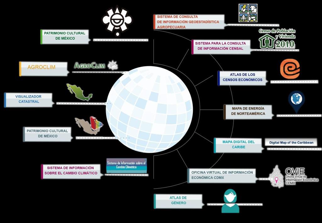
2 I. Digital Map of Mexico Platform Concept Evolution II. Digital Map of Mexico online Concept Capabilities Information available Other state units information III. Digital Map of Mexico for desktop Concept Formats Spatial and statistics analysis IV. MxSIG Concept Advantages Resources available Free software components Standardized services Activities for third parties 2
3 Digital Map of Mexico Platform 3

4 The Digital Map of Mexico (MDM for short) Platform is a set of software tools that allows the integration, construction, query, interpretation and analysis of geographic and georeferenced statistical information. 4

5 MDM with open source software MDM with comercial software 5
6 6


7 Geographic Information System that provides a webcomputing platform to facilitate the use, interpretation and analysis of geographic information and georeferenced statistics. Main users: Decision makers Students People without experience in Geographic Information Systems General citizens 7


8 As Viewer of geographic and statistical information As Geographic Information System To digitize geometries Perform spatial analysis: Areas of influence, intersection, Contents, Data export. Trace source-destination routes and obtain optimal routes. As SDI Incorporate WMS, WFS, TMS and WMTS map web services. Download queries and analysis in data or image formats: pdf, xls, cvs, jpg, png and gif. 8

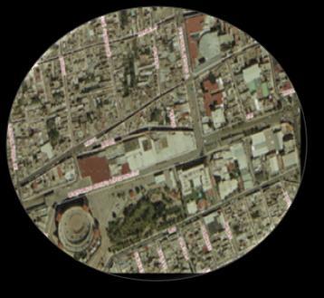
9 More than 225 layers of information and more than 71 million geographic objects, organized into 42 themes. Base Maps: 1. Topographic with and without shading INEGI 2. Hypsographic INEGI 3. Orthophotos INEGI 4. Open Street Map 5. Google Satellite 6. Esri Map No cost and under international OGC standards. Freedom of use and distribution With a network of users, it is subject to continuous improvement. A new version is released every year. Adaptable to different project needs. 9


10 National Directory of Economic Units Economic units DENUE (4 926,061 geo-referenced economic units) Economic Units, municipality of San Blas, Nayarit, Mexico Economic Units, Mexican Republic Economic Units, City of San Blas, Mexico 10


11 Economic Censuses 2014 Geographical levels Federal Entity Municipality Statistical data 12 Economic variables 11 Analytical Relationships Sectors of activity Manufacturing industry Commerce Private non-financial services 11


12 Functional Regionalization of Mexico Rural Urban Systems Rural Urban Subsystems System Articulating Centers Integration Centers of Basic Urban Services Integration Centers of Rural Basic Services Scattered locations Potential Urban Rural Subsystems Potential System Articulating Centers Potential Service Integrator Centers Urban Basics Rural Basics Source: Center of the Mexican Republic * Open Geospatial Consortium 12

13 13


14 Geographic Information System for desktop that is developed to promote and facilitate the integration, interpretation, analysis and use of geographic information and georeferenced statistics. Main Users: Researchers College students People with experience in data analysis 14


15 Points WMS and WMTS Services Lines Polygons Vector files Desktop version Raster files 15


16 Perform statistical analysis Thematic maps, descriptive statistics, linear correlation, multivariate stratification, etc. Associate documentary and tabular information Txt,.doc,.pdf,.xls, etc. Perform spatial analysis operations Extraction, intersection, fusion, union, buffer, Thiessen polygons, Delaunay triangulation, dissolution, decomposition, etc. Other capabilities Support WMS and WMTS standard services Add and manage using coordinates Locate objects using coordinates View files in CAD DXF, DGW, DGN y GPX format Get coordinates, etc 16


. Coverage: Instructors in all states of Mexico.")
17 Objective: To induce the knowledge and use of the tool, through analysis on geographic and statistical information, in order to facilitate to the users the analysis, interpretation and integration of geospatial information. Modalities: 1) Executive Workshop (4 hours) 2) Basic workshop (24 hours). Coverage: Instructors in all states of Mexico. Impact: More than 200 courses and more than 2,000 participants in the last 4 years. 17

18 18


19 19 Open source platform developed at INEGI to implement geomatics solutions for the web that facilitate the use, integration, interpretation, publication and analysis of geographic information and georeferenced statistical information. Digital Map of Mexico on line is powered by MxSIG. MDM MxSIG 20


20 It allows the development of different types of projects and applications with georeferenced information, from a simple viewer with one or two layers of information, to a complete web GIS. Enables user to interact with hundreds of layers of geographic objects and perform spatial analysis on them. It implements advanced functionalities: buffer creation, map algebra, statistical analysis, digitization, timeline, etc. It is based on software with open source license; free of royalty. Supports OGC interoperability standards for geographic information; it can be used in the implementation of national, regional or global SDI, or integrate with existing SDIs. 21


21 Compiled application On INEGI s site Source code On GitHUB Installation Guide On INEGI s site 22


22 PostgreSQL/PostGIS MapServer Open Layers Apache Tomcat Apache HTTP Server jquery 23


23 Supports and promotes the interoperability standards of the Open Geospatial Consortium and the Open Source Geospatial Foundation Web Services supported WMS WFS WMTS TMS WMS-T WCS 24

24 24


25
Institute of Statistical and Geographical Information of Jalisco State Subnational Statistical and Geographical System India.
 Institute of Statistical and Geographical Information of Jalisco State Subnational Statistical and Geographical System India. January 2017 Subnational Statistical and Geographical System National Statistical
1 ST High Level Forum on United Nations Global Geoespatial Information Management GEOGRAPHIC REFERENCING OF ECONOMIC UNITS. México
 1 ST High Level Forum on United Nations Global Geoespatial Information Management Thematic Seminar 27 October, Korea 2011. GEOGRAPHIC REFERENCING OF ECONOMIC UNITS México CONTENTS Introduction Census Cartography
Geospatial Enabling Resilient Development. Latin America Geospatial Forum Río de Janeiro September 2013
 Geospatial Enabling Resilient Development Latin America Geospatial Forum Río de Janeiro September 2013 Presentation Index INEGI /SNIEG Geostatistical Frame - Georeferenciation Issues Legal Framework Mexican
Creating synergies between Statistical and Geospatial information for better policy outputs: The case of Mexico
 Creating synergies between Statistical and Geospatial information for better policy outputs: The case of Mexico Geospatial & Statistics Integration for Informed Decision Making Geospatial World Forum 2017
These modules are covered with a brief information and practical in ArcGIS Software and open source software also like QGIS, ILWIS.
 Online GIS Training and training modules covered are: 1. ArcGIS, Analysis, Fundamentals and Implementation 2. ArcGIS Web Data Sharing 3. ArcGIS for Desktop 4. ArcGIS for Server These modules are covered
Data Aggregation with InfraWorks and ArcGIS for Visualization, Analysis, and Planning
 Data Aggregation with InfraWorks and ArcGIS for Visualization, Analysis, and Planning Stephen Brockwell President, Brockwell IT Consulting, Inc. Join the conversation #AU2017 KEYWORD Class Summary Silos
Paper UC1351. Conference: User Conference Date: 08/10/2006 Time: 8:30am-9:45am Room: Room 23-B (SDCC)
") Conference: User Conference Date: 08/10/2006 Time: 8:30am-9:45am Room: Room 23-B (SDCC) Title of Paper: Increasing the Use of GIS in the Federal Government Author Name: Miss Abstract This presentation
Conference: User Conference Date: 08/10/2006 Time: 8:30am-9:45am Room: Room 23-B (SDCC) Title of Paper: Increasing the Use of GIS in the Federal Government Author Name: Miss Abstract This presentation
Spatial Data Infrastructure Concepts and Components. Douglas Nebert U.S. Federal Geographic Data Committee Secretariat
 Spatial Data Infrastructure Concepts and Components Douglas Nebert U.S. Federal Geographic Data Committee Secretariat August 2009 What is a Spatial Data Infrastructure (SDI)? The SDI provides a basis for
Key Elements of the Geographical Information System of Mexico *
 UNITED NATIONS E/CONF.99/IP.1 ECONOMIC AND SOCIAL COUNCIL Ninth United Nations Regional Cartographic Conference for the Americas New York, 10-14 August 2009 Item 7(a) of the provisional agenda Strategy,
SITR-IDT The Spatial Data Infrastructure of Sardinia Region
 ITALY LOCAL AUTHORITY FOR MUNICIPALITIES, FINANCES AND URBAN PLANNING REGIONAL DEPARTMENT FOR CARTOGRAPHY AND INFORMATION SYSTEMS SITR-IDT The Spatial Data Infrastructure of Sardinia Region Content of
Bentley Map Advancing GIS for the World s Infrastructure
 Bentley Map Advancing GIS for the World s Infrastructure Presentation Overview Why would you need Bentley Map? What is Bentley Map? Where is Bentley Map Used? Why would you need Bentley Map? Because your
ESTABLISHMENT OF KARNATAKA GEOPORTAL AND ITS ROLE IN PLANNING
 ESTABLISHMENT OF KARNATAKA GEOPORTAL AND ITS ROLE IN PLANNING By H. Hemanth Kumar Karnataka State Council for Science & Technology (KSCST), Indian Institute of Science, Bangalore, India Abstract Natural
OSGIS Platform. Storing and distributing PostGIS, Deegree, UMN Map Server Desktop visualization JUMP, QGIS, Thuban, udig, gvsig
 GIS groups of tasks Geodata collecting, updating Geodata storing and distributing Geodata analysis Geodata visualization: Desktop, Internet, Printing Geodata describing: metadata management Geodata converting:
IRDAT Fvg, evolving a regional Spatial Data Infrastructure according to INSPIRE
 IRDAT Fvg, evolving a regional Spatial Data Infrastructure according to INSPIRE Tutti i diritti riservati. Proprietà INSIEL SpA. A. Benvenuti, A. Chiarandini Insiel (Italy) M. Lunardis - Friuli Venezia
Geospatial Products V8i (SELECTseries 1)
") Geospatial Products V8i (SELECTseries 1) Keith Raymond Product Manager Geospatial Desktop Products Presentation Overview What are the various products? Why would you need them? Demonstrations 2 WWW.BENTLEY.COM
Geospatial Products V8i (SELECTseries 1) Keith Raymond Product Manager Geospatial Desktop Products Presentation Overview What are the various products? Why would you need them? Demonstrations 2 WWW.BENTLEY.COM
A Geographer s role in a Google Maps World. Jeremy Bartley ESRI
 A Geographer s role in a Google Maps World Jeremy Bartley ESRI 1 It is a good time to be a Geographer. 2 Microsoft, Google, Yahoo, and others are pushing geographic awareness to the general public Providing
Funding systems used in Mexico to support institutional arrangements: INEGI case
 Funding systems used in Mexico to support institutional arrangements: INEGI case Sistemas de financiamiento usados en México, para soportar arreglos institucionales: Caso INEGI United Nations Committee
Features and Benefits
 Autodesk LandXplorer Features and Benefits Use the Autodesk LandXplorer software family to help improve decision making, lower costs, view and share changes, and avoid the expense of creating physical
The PREVIEW Global Risk Data Platform: a geoportal to serve and share global data on risk to natural hazards
 The PREVIEW Global Risk Data Platform: a geoportal to serve and share global data on risk to natural hazards Gregory Giuliani (UNEP/GRID-Geneva & University of Geneva/enviroSPACE ) http://www.grid.unep.ch
Global Geospatial Information Management Country Report Finland. Submitted by Director General Jarmo Ratia, National Land Survey
 Global Geospatial Information Management Country Report Finland Submitted by Director General Jarmo Ratia, National Land Survey Global Geospatial Information Management Country Report Finland Background
Set-up of subnational statistical systems Statistical Development Strategy for the State of Jalisco México, 2016
 Set-up of subnational statistical systems Statistical Development Strategy for the State of Jalisco México, 2016 Statistical and Geographical Information Institute of Jalisco (IIEG) 2013. Merger of three
Bentley Map Advancing GIS for the World s Infrastructure
 Bentley Map Advancing GIS for the World s Infrastructure Presentation Overview Why would you need Bentley Map? What is Bentley Map? Where is Bentley Map Used? Red text signifies new things in Bentley Map
Spatial data interoperability and INSPIRE compliance the platform approach BAGIS
 Spatial data interoperability and INSPIRE compliance the platform approach BAGIS BAGIS Voluntary, independent, public, non-profit organization; Organization with main mission to promote the growth of the
GIS Building Communities beyond National Borders (Building Successful Spatial Data Infrastructures) Nick Land, ESRI Europe
 Nick Land, ESRI Europe") GIS Building Communities beyond National Borders (Building Successful Spatial Data Infrastructures) Nick Land, ESRI Europe UK worst flooding in the last 60 years 350,000 households without drinking water
GIS Building Communities beyond National Borders (Building Successful Spatial Data Infrastructures) Nick Land, ESRI Europe UK worst flooding in the last 60 years 350,000 households without drinking water
Corporate. Information. Railway Infrastructure Administrator. Year indracompany.com
 geospatial and mobility Corporate Geographic Information System of ADIF Railway Infrastructure Administrator. Year 2009-2010 Corporate Geographic Information System of ADIF ADIF. Spanish Administrator
Web-GIS based Framework for Solid Waste Complaint Management for Sustainable and Smart City
 Cloud Publications International Journal of Advanced Remote Sensing and GIS 2016, Volume 5, Issue 10, pp. 1930-1936 ISSN 2320-0243, DOI: 10.23953/cloud.ijarsg.71 Research Article Open Access Web-GIS based
WEB MAP SERVICE (WMS) FOR GEOLOGICAL DATA GEORGE TUDOR
 FOR GEOLOGICAL DATA GEORGE TUDOR") WEB MAP SERVICE (WMS) FOR GEOLOGICAL DATA GEORGE TUDOR WEB MAP SERVICE (WMS) - GENERALITIES Projects with data from different sources Geological data are in different GIS software format Large amount of
WEB MAP SERVICE (WMS) FOR GEOLOGICAL DATA GEORGE TUDOR WEB MAP SERVICE (WMS) - GENERALITIES Projects with data from different sources Geological data are in different GIS software format Large amount of
Introduction-Overview. Why use a GIS? What can a GIS do? Spatial (coordinate) data model Relational (tabular) data model
 data model Relational (tabular) data model") Introduction-Overview Why use a GIS? What can a GIS do? How does a GIS work? GIS definitions Spatial (coordinate) data model Relational (tabular) data model intro_gis.ppt 1 Why use a GIS? An extension
Introduction-Overview Why use a GIS? What can a GIS do? How does a GIS work? GIS definitions Spatial (coordinate) data model Relational (tabular) data model intro_gis.ppt 1 Why use a GIS? An extension
Techniques for Science Teachers: Using GIS in Science Classrooms.
 Techniques for Science Teachers: Using GIS in Science Classrooms. After ESRI, 2008 GIS A Geographic Information System A collection of computer hardware, software, and geographic data used together for
June 19 Huntsville, Alabama 1
 June 19 Huntsville, Alabama 1 Real-Time Geospatial Data: The Fusion of PI and ArcGIS Enabling Smarter Facilities Management OSIsoft and Esri Mapping and Location Analytics Platform Supporting Your Use
ISO/TR TECHNICAL REPORT. Geographic information Imagery and gridded data. Information géographique Imagerie et données quadrillées
 TECHNICAL REPORT ISO/TR 19121 First edition 2000-10-15 Geographic information Imagery and gridded data Information géographique Imagerie et données quadrillées Reference number ISO/TR 19121:2000(E) ISO
Overview. Everywhere. Over everything.
 Cadenza Desktop Cadenza Web Cadenza Mobile Cadenza Overview. Everywhere. Over everything. The ultimate GIS and reporting suite. Provide, analyze and report data efficiently. For desktop, web and mobile.
One platform for desktop, web and mobile
 One platform for desktop, web and mobile Search and filter Get access to all data thematically filter data in context factually and spatially as well as display it dynamically. Export a selection or send
Evaluating e-government : implementing GIS services in Municipality
 Evaluating e-government : implementing GIS services in Municipality Municipality of Thessaloniki - G.I.S. Unit Misirloglou Symeon Head of the GIS Unit ESRI UC - 2016 The GIS Section - subset of the department
Potential of Geospatial Mashups in Promoting Tourism Resources: A Case Study
 Potential of Geospatial Mashups in Promoting Tourism Resources: A Case Study Somnath Chaudhuri 1 1 Dept. Lenguajes y Sistemas Informaticos Universitat Jaume I, Castellón, Spain Tel.: + 34658184922 som.rtc@gmail.com
GIS Resources for Local Governments
 ISSUE PAPER SERIES GIS Resources for Local Governments February 2018 NEW YORK STATE TUG HILL COMMISSION DULLES STATE OFFICE BUILDING 317 WASHINGTON STREET WATERTOWN, NY 13601 (315) 785-2380 WWW.TUGHILL.ORG
Norwegian spatial data infrastructure supporting disaster risk management Norwegian Mapping Authority
 Norwegian spatial data infrastructure supporting disaster risk management Norwegian Mapping Authority Arvid Lillethun, Norwegian Mapping Authority Land and Poverty 2018 Conference, World Bank 19.-23. March
ArcGIS for INSPIRE. Marten Hogeweg
 ArcGIS for INSPIRE Marten Hogeweg Please Take Our Survey on the App Download the Esri Events app and find your event Select the session you attended Scroll down to find the feedback section Complete answers
INSPIRing Geospatial Framework For Local Administrations
 This project is financed by the European Union and the Republic of Turkey Presented at the FIG Congress 2018, May 6-11, 2018 in Istanbul, Turkey National Programme for Turkey 2010 Instrument for Pre-Accession
From the Venice Lagoon Atlas towards a collaborative federated system
 From the Venice Lagoon Atlas towards a collaborative federated system City of Venice Alessandro Mulazzani CORILA Consortium for Coordination of Research Activities Concerning the Venice Lagoon System ISMAR-CNR
Oman NSDI Supporting Economic Development. Saud Al-Nofli Director of Spatial Data Directorate General of NSDI, NCSI
 Oman NSDI Supporting Economic Development 2017 Saud Al-Nofli Director of Spatial Data Directorate General of NSDI, NCSI "It s critical to make correct decisions the first time to optimize the Investments
IDEBarcelona: Cooperating for a Smart Region Infrastructure
 IDEBarcelona: Cooperating for a Smart Region Infrastructure Marta Codinachs Serra Diputació de Barcelona Territory and Sustainability Area Territorial Information Systems Department SMART CITY EXPO WORLD
Hosted by Esri Official Distributor
 Hosted by Esri Official Distributor Esri European User Conference October 15-17, 2012 Oslo, Norway Hosted by Esri Official Distributor Interoperability and Standards Support in ArcGIS 10.1 Roberto Lucchi
Overview of Geospatial Open Source Software which is Robust, Feature Rich and Standards Compliant
 Overview of Geospatial Open Source Software which is Robust, Feature Rich and Standards Compliant Cameron SHORTER, Australia Key words: Open Source Geospatial Foundation, OSGeo, Open Standards, Open Geospatial
Esri and GIS Education
 Esri and GIS Education Organizations Esri Users 1,200 National Government Agencies 11,500 States & Regional Agencies 30,800 Cities & Local Governments 32,000 Businesses 8,500 Utilities 12,600 NGOs 11,000
Geospatial information integration for city management and development in Rio de Janeiro
 Geospatial information integration for city management and Leandro Gomes Souza Geographer Luiz Roberto Arueira da Silva Director of City Information Pereira Passos Institute - City of Rio de Janeiro About
Geo-Enabling Digital India. 15 th Esri India User Conference GIS and Smart Cities
 15 th Esri India User Conference 2014 GIS and Smart Cities 15 th Esri India User Conference 2014 GIS and Smart Cities Agendra Kumar President, Esri India Our World Is Facing Serious Challenges Our World
TRANSFORMATION THROUGH CLC WITH THE CONTINUOUS RESEARCH TECHNIQUES - GIS (OPEN CODE) AND RS (GEO-WEB SERVICES)
 AND RS (GEO-WEB SERVICES)") DOI 10.2478/pesd-2018-0036 PESD, VOL. 12, no. 2, 2018 TRANSFORMATION THROUGH CLC WITH THE CONTINUOUS RESEARCH TECHNIQUES - GIS (OPEN CODE) AND RS (GEO-WEB SERVICES) Florim Isufi 1, Shpejtim Bulliqi 2,
DOI 10.2478/pesd-2018-0036 PESD, VOL. 12, no. 2, 2018 TRANSFORMATION THROUGH CLC WITH THE CONTINUOUS RESEARCH TECHNIQUES - GIS (OPEN CODE) AND RS (GEO-WEB SERVICES) Florim Isufi 1, Shpejtim Bulliqi 2,
A Vision for ArcGIS Applying Geography Everywhere
 A Vision for ArcGIS Applying Geography Everywhere WELCOME PURPOSE A Network of GIS Professionals Are Awakening the World to the Power of Web GIS You Your WORK Making a Difference Your Work Open Maps and
MEXICO s approach to geographic disaggregation for the SDGs and the 2020 Census. Eduardo de la Torre INEGI - México
 MEXICO s approach to geographic disaggregation for the SDGs and the 2020 Census Eduardo de la Torre INEGI - México INEGI and the National System of Statistical and Geographic Information (SNIEG) Since
Portals: Standards in Action
 Portals: Standards in Action David Danko ISO TC 211 Metadata Project Leader GIS Standards Consultant-ESRI. Metadata Portals Portal gateway, place of entry Producers Advertise, expose products Share information
BROADBAND DEMAND AGGREGATION: PLANNING BROADBAND IN RURAL NORTHERN CALIFORNIA
 BROADBAND DEMAND AGGREGATION: PLANNING BROADBAND IN RURAL NORTHERN CALIFORNIA Steven J. Steinberg, Ph.D a,b, *, Rebecca Degagne a, M.S., Michael Gough a a Institute for Spatial Analysis, Humboldt State
COURSE INTRODUCTION & COURSE OVERVIEW
 week 1 COURSE INTRODUCTION & COURSE OVERVIEW topics of the week Instructor introduction Students introductions Course logistics Course objectives Definition of GIS The story of GIS introductions Who am
Innovation. The Push and Pull at ESRI. September Kevin Daugherty Cadastral/Land Records Industry Solutions Manager
 Innovation The Push and Pull at ESRI September 2004 Kevin Daugherty Cadastral/Land Records Industry Solutions Manager The Push and The Pull The Push is the information technology that drives research and
Modern Education at Universities: Improvements through the Integration of a Spatial Data Infrastructure SDI into an e-learning Environment
 Modern Education at Universities: Improvements through the Integration of a Spatial Data Infrastructure SDI into an e-learning Environment Ingo Simonis Institute for Geoinformatics, University of Muenster
A Distributed GIS Architecture for Research in Baalbek Based on CISAR
 234 Frank Henze A Distributed GIS Architecture for Research in Baalbek Based on CISAR Abstract: Research underway in Baalbek extends from the immediate vicinity of the excavation areas to the monumental
Geographic Information Systems (GIS) in Environmental Studies ENVS Winter 2003 Session III
 in Environmental Studies ENVS Winter 2003 Session III") Geographic Information Systems (GIS) in Environmental Studies ENVS 6189 3.0 Winter 2003 Session III John Sorrell York University sorrell@yorku.ca Session Purpose: To discuss the various concepts of space,
Geographic Information Systems (GIS) in Environmental Studies ENVS 6189 3.0 Winter 2003 Session III John Sorrell York University sorrell@yorku.ca Session Purpose: To discuss the various concepts of space,
ARCGIS PRO COURSE, BEGINNER LEVEL ONLINE TRAINING GIS. Course. Training. .com
 ARC PRO COURSE, BEGINNER LEVEL ONLINE TRAINING Course.com TYC TRAINING OVERVIEW This course will provide a basic introduction in Arc PRO, the new Arc Desktop release. The training material will be focused
ARCGIS COURSE, BEGINNER LEVEL ONLINE TRAINING
 ARC COURSE, BEGINNER LEVEL ONLINE TRAINING Course.com TYC TRAINING OVERVIEW This course will qualify students to use Arc Desktop 10 and in particular, ArcMap, ArcCatalog and ArcTool Box, focusing on the
A Spatial Data Infrastructure dedicated to scientific research and observation of the coastal environment
 A Spatial Data Infrastructure dedicated to scientific research and observation of the coastal environment http://indigeo.fr Mathias ROUAN - Research Engineer - UMR 6554 LETG CNRS Littoral, Environment,
DESIGNING AND APPLICATION OF WEB-BASED GEOGRAPHICAL INFORMATION SYSTEM FOR VISUAL ASSESSMENT OF LAND LEVELS
 DOI: 10.21917/ijsc.2018.0235 DESIGNING AND APPLICATION OF WEB-BASED GEOGRAPHICAL INFORMATION SYSTEM FOR VISUAL ASSESSMENT OF LAND LEVELS Ri NamSong, Choe JongAe and Kim Jonggun Institute of Information
Building a national spatial data infrastructure. Thorben Hansen, Head of Division Danish Agency for Data Supply and Efficiency
 Building a national spatial data infrastructure Thorben Hansen, Head of Division Danish Agency for Data Supply and Efficiency About Spatial Data Infrastructure Spatial data come from many sources and is
European Location Framework data in the ArcGIS platform
 European Location Framework data in the ArcGIS platform Presentation to: Author: Date: INSPIRE Conference 2016 Clemens Portele 26 September 2016 Why ELF? Global (e.g. UN GGIM) Regional Europe (INSPIRE
Bentley Map V8i (SELECTseries 3)
") Bentley Map V8i (SELECTseries 3) A quick overview Why Bentley Map Viewing and editing of geospatial data from file based GIS formats, spatial databases and raster Assembling geospatial/non-geospatial data
Bentley Map V8i (SELECTseries 3) A quick overview Why Bentley Map Viewing and editing of geospatial data from file based GIS formats, spatial databases and raster Assembling geospatial/non-geospatial data
Preparation of Database for Urban Development
 Preparation of Database for Urban Development By PunyaP OLI, 1. Chairman, ERMC (P) Ltd., Kathmandu, Nepal. Email: punyaoli@ermcnepal.com 2. Coordinator, Himalayan College of Geomatic Engineering and Land
Zagreb Spatial Data Infrastructure. Sanja Batić, APIS IT Split, 14. rujna 2011.
 Zagreb Spatial Data Infrastructure Sanja Batić, APIS IT Split, 14. rujna 2011. Agenda Zagreb Spatial Data Infrastructure - ZIPP Guidelines for further ZIPP Geoportal development Conclusion 1964 The Centre
Regional Spatial Data Infrastructures What Makes them Possible?
 Article for Geoinformatics June 2007 Regional Spatial Data Infrastructures What Makes them Possible? by Sam Bacharach Executive Director Outreach Open Geospatial Consortium, Inc. (OGC) INTRODUCTION The
Developing 3D Geoportal for Wilayah Persekutuan Iskandar
 Developing 3D Geoportal for Wilayah Persekutuan Iskandar Dionnald Beh BoonHeng and Alias Abdul Rahman Department of Geoinformatics, Faculty of Geoinformation Engineering and Sciences, Universiti Teknologi
Free and Open Source Software for Cadastre and Land Registration : A Hidden Treasure? Gertrude Pieper Espada. Overview
 Free and Open Source Software for Cadastre and Land Registration : A Hidden Treasure? Gertrude Pieper Espada Overview FLOSS concepts Digital Land Administration systems FLOSS Database alternatives FLOSS
A Web Service based U.S. Cropland Visualization, Dissemination and Querying System
 A Web Service based U.S. Cropland Visualization, Dissemination and Querying System Rick Mueller and Zhengwei Yang USDA/National Agricultural Statistics Service Weiguo Han and Liping Di GMU/Center for Spatial
What is GIS? ESRI Canada. August 2011
 What is GIS? ESRI Canada August 2011 Geography Matters! Environmental Park Management Agriculture Public Utilities Health Care Emergency 911 Real Estate Marketing Environmental What are the effects of
Evaluating Sustainability of the Georesources Observation System
 Evaluating Sustainability of the Georesources Observation System Michael Mente Federal Institute for Geosciences and Natural Resources Germany, Hannover GEOSS-CBC Meeting Athens April 27th 28th, 2009 GEOSS-CBC
Imagery and the Location-enabled Platform in State and Local Government
 Imagery and the Location-enabled Platform in State and Local Government Fred Limp, Director, CAST Jim Farley, Vice President, Leica Geosystems Oracle Spatial Users Group Denver, March 10, 2005 TM TM Discussion
Institute of Statistical and Geographical Information of Jalisco State Geospatial Technologies, platforms and services at a subnational level
 Institute of Statistical and Geographical Information of Jalisco State Geospatial Technologies, platforms and services at a subnational level México, November 2017 Unique organization in its type SDG 17.18:
POSSIBILITY FOR APPLICATION OF GIS TECHNOLOGIES IN RTB BOR GROUP
 MINING AND METALLURGY INSTITUTE BOR UDK: 622 ISSN: 2334-8836 (Štampano izdanje) ISSN: 2406-1395 (Online) UDK: 681.33:622.343(045)=111 doi:10.5937/mmeb1603021v Nenad Vušović *, Marko Vuković **, Igor Svrkota
What s new in GIS. RAL Retreat Oct 5, 2005
 What s new in GIS RAL Retreat Oct 5, 2005 Overview GIS Initiative milestones Major activities in 2004-2005 GALEON UNIDATA OGC project New functionality in ESRI software GIS Initiative Team Olga Wilhelmi
INSPIRE General Introduction & Service Architecture
 INSPIRATION Spatial Data Infrastructure in the Western Balkans INSPIRE General Introduction & Service Architecture 1st National INSPIRATION Workshop Croatia November 21-22, 2012 A multi-countryprojectfunded
USDA CropScape Data Resources
 USDA CropScape Data Resources Zhengwei Yang, Claire Boryan, Rick Mueller USDA National Agricultural Statistics Service, Washington, DC 20250, USA Collaborators: Liping Di, Weiguo Han Center for Spatial
The Polar Data Landscape
 The Polar Data Landscape Polar Data Activities, Models and Issues from Local to Global Peter L. Pulsifer, NSIDC, GCRC Carleton University Cameron Wilson, Natural Resources Canada (NRCan) Martha Paiz, Natural
Geoprovisioning delivers geodata and its analysis for specific areas on request.
 DRAFT 27 February 2009 Geoprovisioning Geoprovisioning delivers geodata and its analysis for specific areas on request. What are the components of a geoprovisioning service? The sample web site geoprovisioning.com
Report of Uruguay The National Spatial Data Infrastructure
 Report of Uruguay The National Spatial Data Infrastructure Prepared for High-Level Forum on Global Geospatial Information Management (GGIM) and Inaugural Session of the UN Committee of Experts on GGIM
ARCGIS PRO COURSE, APPLIED TO ENVIROMENTAL MANAGEMENT GIS. Course. Training. .com
 ARC PRO COURSE, APPLIED TO ENVIROMENTAL MANAGEMENT TYC Training Course.com TRAINING OVERVIEW This Arc Pro online course will provide a great deal of information about the link between earth s ecosystems
Working with ArcGIS Online
 Esri International User Conference San Diego, CA Technical Workshops July 12, 2011 Working with ArcGIS Online Bern Szukalski, Deane Kensok Topics for this Session ArcGIS Online Overview ArcGIS Online Content
ARCGIS COURSE, FROM BEGINNER TO ADVANCED LEVEL ONLINE TRAINING. GIS Training. Course. .com
 ARC COURSE, FROM BEGINNER TO ADVANCED LEVEL ONLINE TRAINING Training Course.com TYC TRAINING OVERVIEW This course will qualify students in the management of Arc Desktop 10 and in particular, ArcMap, ArcCatalog
Massachusetts Institute of Technology Department of Urban Studies and Planning
 Massachusetts Institute of Technology Department of Urban Studies and Planning 11.520: A Workshop on Geographic Information Systems 11.188: Urban Planning and Social Science Laboratory GIS Principles &
Salisbury University: Eric Flint, John O Brien, & Alex Nohe
 Salisbury University: Eric Flint, John O Brien, & Alex Nohe Open Source (Public) Geographic Information System GNU General Public License Guarantees public s ability to download, modify and share software
Reprint of article that appeared in Hydro INTERNATIONAL November 2006 Volume 10 Issue 9
 Reprint of article that appeared in Hydro INTERNATIONAL November 2006 Volume 10 Issue 9 While Google Earth is the best known 3D web-mapping viewer currently in the public domain, there are alternative
Implementing INSPIRE Geoportal in Turkey
 Implementing INSPIRE Geoportal in Turkey Gencay SERTER City and Regional Planner 1 Presentation Plan Introduction INSPIRE and Turkey Importance of al Spatial Planning Portal Logical&Legal Hierarchy GeoPortal
Questions and Answers
 AUTODESK LANDXPLORER SOFTWARE FAMILY Questions and Answers The Autodesk LandXplorer 3D city model software family can help you create, analyze, and visualize digital city models. Contents Autodesk Landxplorer
Desktop GIS for Geotechnical Engineering
 Desktop GIS for Geotechnical Engineering Satya Priya Deputy General Manager (Software) RMSI, A-7, Sector 16 NOIDA 201 301, UP, INDIA Tel: +91-120-2511102 Fax: +91-120-2510963 Email: Satya.Priya@rmsi.com
Global 3D Models with Local Content
 Gunnar Misund Associate Professor Head of Environmental Computing gunnar.misund@hiof.no - Morten Granlund, Scientfic Assistant Herman Kolås, Master Student Mats Lindh, Master Student - Østfold University
Technical Specifications. Form of the standard
 Used by popular acceptance Voluntary Implementation Mandatory Legally enforced Technical Specifications Conventions Guidelines Form of the standard Restrictive Information System Structures Contents Values
QGIS COURSE - ROUTE ANALYSIS, FINDING THE SHORT PATH IN QGIS ONLINE TRAINING. GIS Training. Course. .com
 Q COURSE - ROUTE ANALYSIS, FINDING THE SHORT PATH IN Q ONLINE TRAINING Training Course.com TYC COURSE GOALS The objective of this course is to initiate the student in route analysis using Q. The training
Development of Univ. of San Agustin Geographic Information System (USAGIS)
") , pp.170-176 http://dx.doi.org/10.14257/astl.2014.48.27 Development of Univ. of San Agustin Geographic Information System (USAGIS) Rosslin John H. Robles Chair, Computer Science Department, University
, pp.170-176 http://dx.doi.org/10.14257/astl.2014.48.27 Development of Univ. of San Agustin Geographic Information System (USAGIS) Rosslin John H. Robles Chair, Computer Science Department, University
Sustainable and Harmonised Development for Smart Cities The Role of Geospatial Reference Data. Peter Creuzer
 Sustainable and Harmonised Development for Smart Cities The Role of Geospatial Reference Data Peter Creuzer 1. Introduction - Smart Cities and Geodata 2. Geodata in Germany 3. Examples 4. Data and Service
You are Building Your Organization s Geographic Knowledge
 You are Building Your Organization s Geographic Knowledge And Increasingly Making it Available Sharing Data Publishing Maps and Geo-Apps Developing Collaborative Approaches Citizens Knowledge Workers Analysts
GIS at UCAR. The evolution of NCAR s GIS Initiative. Olga Wilhelmi ESIG-NCAR Unidata Workshop 24 June, 2003
 GIS at UCAR The evolution of NCAR s GIS Initiative Olga Wilhelmi ESIG-NCAR Unidata Workshop 24 June, 2003 Why GIS? z z z z More questions about various climatological, meteorological, hydrological and
Spread over a central peninsula and its surroundings, Split's greater area includes the surrounding seaside towns as well.
 Split is a Mediterranean city on the eastern shores of the Adriatic Sea, centered around the ancient Roman Palace of the Emperor Diocletian and its bay and port. With a population of 178,192 citizens,
Existing Open Source Tools and Possibilities for Cadastre Systems
 Existing Open Source Tools and Possibilities for Cadastre Systems Gertrude Pieper Espada FIG Congress Sydney, 11-16 April 2010 What is FLOSS? What is open source? What open source software tools are available?
E-Government and SDI in Bavaria, Germany
 135 E-Government and SDI in Bavaria, Germany Wolfgang STOESSEL, Germany Key words: GDI-BY, Bavaria, Spatial Data Infrastructure SUMMARY Spatial Data Infrastructure (SDI) is an important part of the e-government