Welcome. C o n n e c t i n g
|
|
|
- Gwendolyn Wright
- 5 years ago
- Views:
Transcription

1 Welcome C o n n e c t i n g

2 YOU D i s c i p l i n e s

3 Why is This Meeting......So Important Now?

4 OUR WORLD Is Increasingly Challenged The Evidence Is Clear We Need Better Understanding and More Collaboration Loss of Nature Urbanization Population Pollution Biodiversity Inequality Consumption Migration Climate Change Social Conflict Food Natural Disasters Energy Political Polarization Water and Action

5 OUR WORLD Is Undergoing a Massive Digital Transformation

6 A Fundamental Digital Language For Understanding and Managing Our World


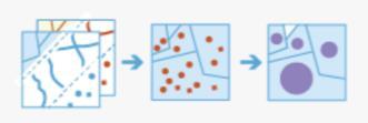
7 Geography and Statistical Data Are Foundational An Integrated Data Model is Essential Boundaries Census Data Key EA Id Population Male Femal e Nested Administrative Hierarchy EA Id Area Provinces Districts EA Id Num HH Avg HH size Localities Enumeration Areas
8 Enabling Understanding


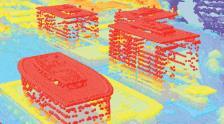
9 Imagery is an Essential Data Source Integrating Earth Observations and Providing Periodic Reporting Tree Canopy Analytics Key Tree Canopy EA Id Density Own Height EA Id Area Crop Health Crop Health EA Id Moisture Vigor Land Cover EA Id Land Cover PrimaryType % change Image Integration and Machine Learning are Becoming a Fundamental Part of a Modern GIS


 Quality /")
10 Integration of Statistical and Geospatial Data Geospatial Framework (GSGF) Statistical Process Model (GSBPM) Quality / Metadata Management


11 A Framework and Process Data Management & Integration Mapping & Tabulation Analysis & Modeling Planning & Design Decision Making Action Transforming How We Collaborate and Act... Providing a More Integrated Approach

12 GIS Provides a Platform For Managing, Analyzing, and Applying Geographic, Statistical & Imagery Information Integrating People, Processes, Things, and Data About Them Using the Power of Where to Integrate Everything


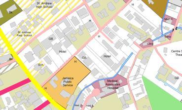


13 GIS Applications Across UN-GGIM Working Groups Topographical Mapping Official Statistics Cadastral Comprehensive Planning Korea KICT Multiscale Topo Map Jamaica National Land Agency Maritime US Census Bureau Poverty Vulnerable Populations Disaster Preparedness Japan Kajima Corporation Imagery Bathymetry Population Change Access to Health Facilities Global Foundation Switzerland swisstopo NGA Change Analysis Korea Incheon Metropolitan City Haiti UNICEF

14 GIS Is Advancing Rapidly Integrating and Leveraging Many Innovations Web GIS Easier, Open and Accessible Data Computing Infrastructure GIS Innovation Open APIs Expanding the Power of GIS


15 Web GIS Is the Modern GIS Architecture Helping Everyone Do Their Work Better Organizations Growing Exponentially Departments Teams Individuals Leveraging Web Services Sharing Knowledge Collaboration Improving Productivity and Efficiency


16 Web GIS Simplifies Working With All Types of Data Using Web Maps, Scenes, and Layers Creating A Common Language Apps Distributed Map Lidar Tabular Imagery 3D Real-Time (IoT) Big Data


17 Apps Make the System Come Alive Leveraging Open Data and Services Planning Apps Viewer Apps Social Media Analytic Apps Story Maps Dashboards Field Apps Across Organizations and Beyond

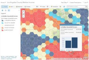
18 Smart Mapping and Exploratory Data Analysis Simplifies the Use of Analytics and Creates Beautiful Maps


19 Advanced Spatial Analysis Web-Based Analysis Spatial Statistics Many Enhancements Hot Spot Outliers Vector Analysis In Space-Time Cubes Dynamic Aggregation Model Builder Space-Time Pattern Mining Space-Time Point Aggregation Optimum Site Selection Areal Interpolation Optimized VRP Clustering Enhanced Cube Explorer Science Integration Charting Geostatistical Wizard Improved Processing Integration of Raster and Lidar Parallel Processing New Raster Functions ArcGIS API for Python Machine Learning Tools Improved R Integration Big Data Analytics Improved Slope/Aspect LAS Classification


")


20 Big Data Spatial Analytics Faster and Massively Scalable Spatial Observations Large Collections and Real Time Imagery Large Imagery Collection Space-Time Cube Riparian Areas Power Outages (50+ Million) Density Hot Spots Imagery Lidar: Bare Earth Lidar: First Return Faster (10x+) Leveraging Distributed Computing, Machine Learning and Parallel Processing
21 Web GIS Enables New Types of Collaboration Connecting Individuals, Organizations and Communities Individuals Organizations Communities... Creating New Connections and Opportunities

22 Connecting Everyone Using Web Maps and Apps to Share and Collaborate Supporting Communication and Real-Time Awareness Communities Organizations People Creating a System of Engagement


 Transparency")


23 Web GIS Enables Community Engagement Organizing and Managing Community Interactions Vision Zero Providing Citizens Information And Leaders Input Citizen Communication Citizen Surveys (Crowdsourcing) Transparency Open Data Status Reporting Community GIS Hub Open Data Storytelling Demographic Information Policy Initiative Based Urban Planning Demographic Reporting Using Shared Templates f


24 Web GIS Enables National SDI
25 Web GIS Enables Whole New Scale of GIS Helping Everyone do Their Work Better Departments Organizations Teams System of Systems Individuals Leveraging Web Services Sharing Knowledge Collaboration Improving Productivity and Efficiency
26 GIS Now Provides the Means.. SDGs... For Creating Federated Systems
27 The UN is Working with Member States to Develop a Web System for Reporting on the SDG s


28 Population Below Poverty Line Food Supply Crop Rotation UN-Yemen Ireland Malnutrition Poverty Incidence USA Healthy Food Access Precision Agriculture World Philippines California New Zealand


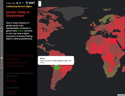

29 Disparity of School Access Gender Ratio School Performance Washington, DC Child Maltreatment Prediction Tanzania Traffic Accidents and Schools Gender Equality London Global Texas Japan


30 UNSD Created Applications for SDG Reporting Story Maps Illustrate Data Driven Progress


31 Information Products Can Be Published Using An Open, Interoperable, and Services-based Approach


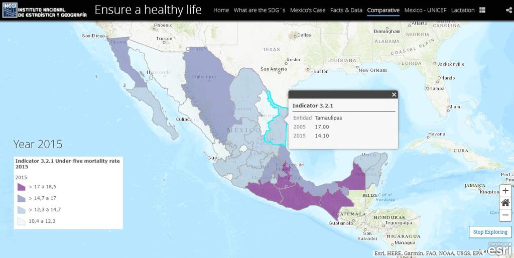
32 Tools Like This... Are Already Determining Mexico s Development Progress

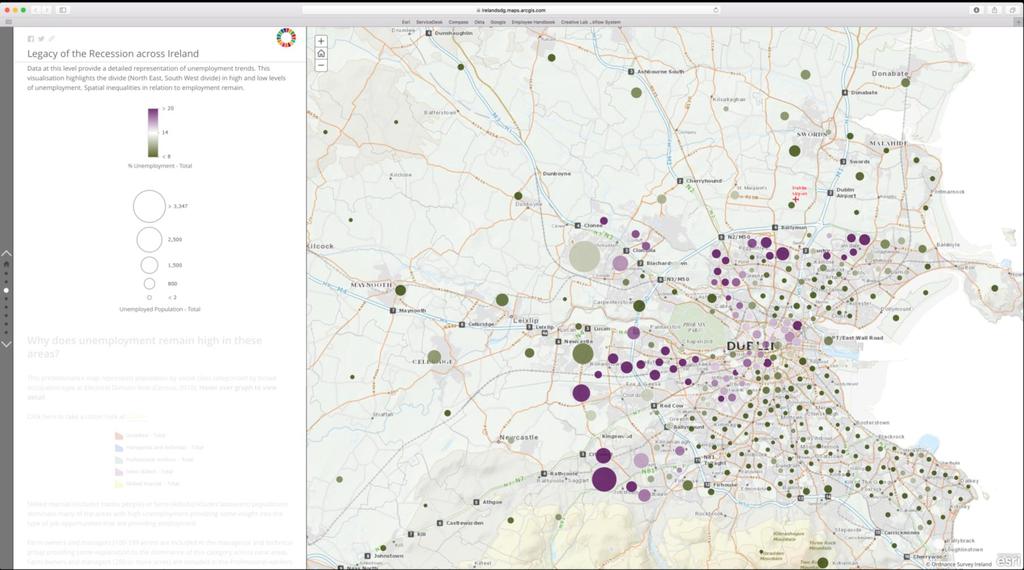
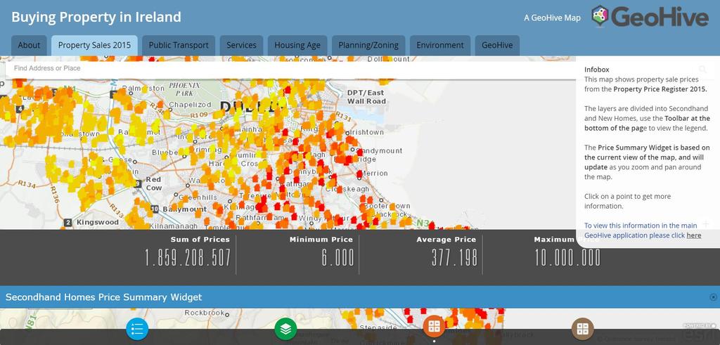
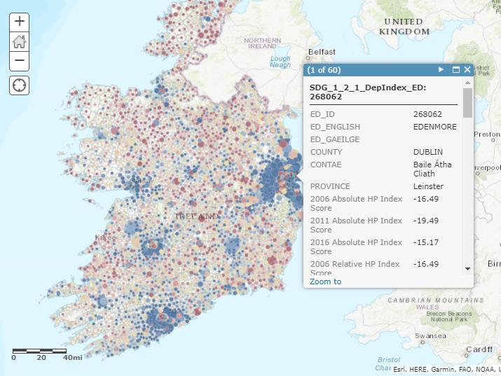
33 Helping Ireland Understand Where to Apply Resources
34 Empowering the Philippines To Understand Poverty


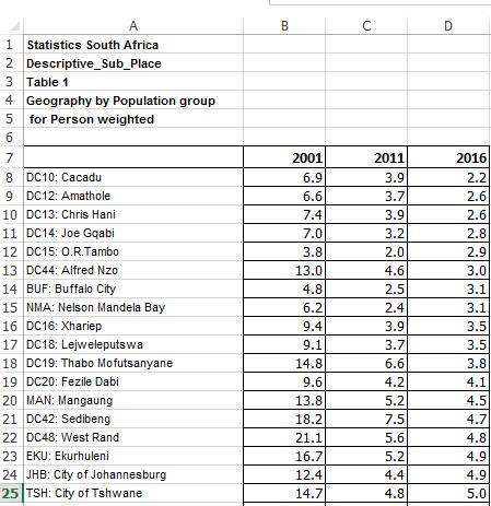
35 Helping South Africa Visualize Statistical Patterns

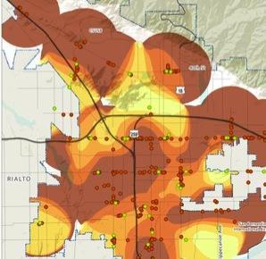
36 PUBLIC SAFETY
37 Web GIS Has Enabled a Global SDG Hub Initiatives A UN Network (Initiatives, Templates and National Data) UN SDG Hub Network Data Policy Initiatives


38 ... and a Network of National SDG Hubs Supporting National and Partner Initiatives Ireland.Open for everyone, an inclusive and enabling environment

39 A Federated System for the SDGs Is Emerging Creating a System of Systems Making Data Available to Governments, the Civil Society and Citizens Evaluate, Enhance & Scale Capacity Educate and Train Building Dashboards Determine Indicator Data Inventory Existing Data Federation Prioritize Indicators Data Preparation Story Maps Hub Vision Assess & Plan January 2017 Initial Operating Capability Months 1 & 2 Operate & Expand Months 3 & 4 Months 5 & 6 Enablement Implementation Planning Form Internal Team ID Data Gaps Initiatives Maps and Apps Configuration Spatial Data Partners Architecture Design Open Data Distributed System Driven By Participating Member States Country Owned and Country Led
40 Humans Are More Capable Than Ever... of Sharing and Applying Geographic Knowledge... of Understanding and Acting

41 Technology Is Not Enough... Tech-Savvy Leadership Understanding What's Needed Data-Driven Culture Collaboration Across Departments Willingness to Learn Citizen andprivate Sector Engagement Good People / Good Attitude / Good Relationships

42 The pieces are fitting into place Creating a Platform for Managing our Future
Geography for the 2020 Round of Census
 Boundaries Key Census Data EA Id Population Male Female EA Id Area EA Id Num HH Avg HH size Geography for the 2020 Round of Census Linda Peters, Esri lpeters@esri.com Integration of Statistical and Geospatial
Esri and GIS Education
 Esri and GIS Education Organizations Esri Users 1,200 National Government Agencies 11,500 States & Regional Agencies 30,800 Cities & Local Governments 32,000 Businesses 8,500 Utilities 12,600 NGOs 11,000
The Pace of Change Is Accelerating Creating Many Challenges
 VISION The Pace of Change Is Accelerating Creating Many Challenges Evidence Threatening Our Natural World and Our Future as Humans Social Conflict Mass Migration Ocean Acidification Food Population Urbanization
Foundation Geospatial Information to serve National and Global Priorities
 Foundation Geospatial Information to serve National and Global Priorities Greg Scott Inter-Regional Advisor Global Geospatial Information Management United Nations Statistics Division UN-GGIM: A global
Spatial Analysis with Web GIS. Rachel Weeden
 Spatial Analysis with Web GIS Rachel Weeden Agenda Subhead goes here Introducing ArcGIS Online Spatial Analysis Workflows Scenarios Other Options Resources ArcGIS is a Platform Making mapping and analytics
A Vision for ArcGIS Applying Geography Everywhere
 A Vision for ArcGIS Applying Geography Everywhere WELCOME PURPOSE A Network of GIS Professionals Are Awakening the World to the Power of Web GIS You Your WORK Making a Difference Your Work Open Maps and
ArcGIS for INSPIRE. Marten Hogeweg Satish Sankaran
 ArcGIS for INSPIRE Marten Hogeweg Satish Sankaran Outline What is ArcGIS ArcGIS for INSPIRE Web GIS Case Studies Roadmap Q&A What is INSPIRE? INSPIRE is the legal framework for a European Spatial Data
OFWIM 2017 Annual Conference What Does Web GIS Really Mean for Fish and Wildlife Agencies?
 Content Open Mapping OFWIM 2017 Annual Conference What Does Web GIS Really Mean for Fish and Wildlife Agencies? Imagery Spatial Analysis Mike Bialousz, Esri 3D Data Exploration Real-Time Apps Visualization
ArcGIS for INSPIRE. Marten Hogeweg
 ArcGIS for INSPIRE Marten Hogeweg Please Take Our Survey on the App Download the Esri Events app and find your event Select the session you attended Scroll down to find the feedback section Complete answers
Tools to Assess Local Health Needs. Richard Leadbeater, Esri NACo 2011 Healthy Counties Forum December 1, 2011
 Tools to Assess Local Health Needs Richard Leadbeater, Esri NACo 2011 Healthy Counties Forum December 1, 2011 Richard Leadbeater currently holds the position of Industry Solutions Manager with Esri. He
Smart Land Administration. Brent A. Jones, PE, PLS
 Smart Land Administration Brent A. Jones, PE, PLS bjones@esri.com What is Smart? Required Important Modern Open Secure Authoritative Sustainable Cost Effective Reliable Scalable Contributory Usable Timely
Implementing the Sustainable Development Goals: The Role of Geospatial Technology and Innovation
 Fifth High Level Forum on UN Global Geospatial Information Management Implementing the Sustainable Development Goals: The Role of Geospatial Technology and Innovation 28-30 November 2017 Sheraton Maria
GEOGRAPHIC INFORMATION SYSTEMS Session 8
 GEOGRAPHIC INFORMATION SYSTEMS Session 8 Introduction Geography underpins all activities associated with a census Census geography is essential to plan and manage fieldwork as well as to report results
ArcGIS is Advancing. Both Contributing and Integrating many new Innovations. IoT. Smart Mapping. Smart Devices Advanced Analytics
 ArcGIS is Advancing IoT Smart Devices Advanced Analytics Smart Mapping Real-Time Faster Computing Web Services Crowdsourcing Sensor Networks Both Contributing and Integrating many new Innovations ArcGIS
Integrating Official Statistics and Geospatial Information NBS Experience
 Integrating Official Statistics and Geospatial Information NBS Experience Presented by Eng. Reda AL Sabbagh Director of IT Dept. Prepared by Eng. Adham Makky GIS Specialist Topics to be covered: Background
US National Spatial Data Infrastructure A Spatial Framework for Governance and Policy Development to Enable a Location-Based Digital Ecosystem
 GeoPlatform Workshop 7 Dec 2016, Department of the Interior Washington, D.C. US National Spatial Infrastructure A Spatial Framework for Governance and Policy Development to Enable a Location-Based Digital
Disaster Management & Recovery Framework: The Surveyors Response
 Disaster Management & Recovery Framework: The Surveyors Response Greg Scott Inter-Regional Advisor Global Geospatial Information Management United Nations Statistics Division Department of Economic and
Key Points Sharing fosters participation and collaboration Metadata has a big role in sharing Sharing is not always easy
 Sharing Resources Geoff Mortson esri, Inc. SDI Solutions Team Key Points Sharing fosters participation and collaboration Metadata has a big role in sharing Sharing is not always easy Data Sharing is Good
UN-GGIM: Strengthening Geospatial Capability
 Fifth Plenary Meeting of UN-GGIM: Europe Brussels, 6-7 June 2018 UN-GGIM: Strengthening Geospatial Capability Walking the talk to leave no one behind Greg Scott, UN-GGIM Secretariat Environmental Statistics
INDONESIA S S UPDATE: GEOSPATIAL INFORMATION FOR SUSTAINABLE DEVELOPMENT RELATED TO INA SDI Dr. Asep Karsidi, M.Sc
 INDONESIA S S UPDATE: GEOSPATIAL INFORMATION FOR SUSTAINABLE DEVELOPMENT RELATED TO INA SDI Dr. Asep Karsidi, M.Sc GEOSPATIAL INFORMATION AGENCY 08 August, 2012 OUTLINE 1. Transformation Bakosurtanal into
THE ROLE OF GEOSPATIAL AT THE WORLD BANK
 THE ROLE OF GEOSPATIAL AT THE WORLD BANK INSPIRE Conference Barcelona, Spain September 26, 2016 Kathrine Kelm Senior Land Administration Specialist Global Land and Geospatial Unit The World Bank Group
Leveraging the Technology Revolution
 Leveraging the Technology Revolution Science, technology, and innovation to measure and monitor progress Moxie Zhang 张剑宇 We are living in a world that is constantly under development Our World Is full
Geo-Enabling Digital India. 15 th Esri India User Conference GIS and Smart Cities
 15 th Esri India User Conference 2014 GIS and Smart Cities 15 th Esri India User Conference 2014 GIS and Smart Cities Agendra Kumar President, Esri India Our World Is Facing Serious Challenges Our World
You are Building Your Organization s Geographic Knowledge
 You are Building Your Organization s Geographic Knowledge And Increasingly Making it Available Sharing Data Publishing Maps and Geo-Apps Developing Collaborative Approaches Citizens Knowledge Workers Analysts
Spatially Enabled Society
 International Seminar on Land Administration Trends and Issues in Asia and the Pacific Region Spatially Enabled Society Abbas Rajabifard Vice Chair PCGIAP-WG3 Vice-President (President Elect), GSDI Association
Urban Climate Resilience
 Urban Climate Resilience in Southeast Asia Partnership Project Introduction Planning for climate change is a daunting challenge for governments in the Mekong Region. Limited capacity at the municipal level,
GOVERNMENT MAPPING WORKSHOP RECOVER Edmonton s Urban Wellness Plan Mapping Workshop December 4, 2017
 GOVERNMENT MAPPING WORKSHOP 12.4.17 RECOVER Edmonton s Urban Wellness Plan Mapping Workshop December 4, 2017 In July of 2017, City Council directed administration to develop RECOVER, Edmonton s Urban Wellness
June 19 Huntsville, Alabama 1
 June 19 Huntsville, Alabama 1 Real-Time Geospatial Data: The Fusion of PI and ArcGIS Enabling Smarter Facilities Management OSIsoft and Esri Mapping and Location Analytics Platform Supporting Your Use
The Global Statistical Geospatial Framework and the Global Fundamental Geospatial Themes
 The Global Statistical Geospatial Framework and the Global Fundamental Geospatial Themes Sub-regional workshop on integration of administrative data, big data and geospatial information for the compilation
Oak Ridge Urban Dynamics Institute
 Oak Ridge Urban Dynamics Institute Presented to ORNL NEED Workshop Budhendra Bhaduri, Director Corporate Research Fellow July 30, 2014 Oak Ridge, TN Our societal challenges and solutions are often local
Applying Health Outcome Data to Improve Health Equity
 Applying Health Outcome Data to Improve Health Equity Devon Williford, MPH, Health GIS Specialist Lorraine Dixon-Jones, Policy Analyst CDPHE Health Equity and Environmental Justice Collaborative Mile High
GIS for Crime Analysis. Building Better Analysis Capabilities with the ArcGIS Platform
 GIS for Crime Analysis Building Better Analysis Capabilities with the ArcGIS Platform Crime Analysis The Current State One of the foundations of criminological theory is that three things are needed for
LEARNING CREATING RELATIONSHIPS UNDERSTANDING INSPIRING SHARING CONNECTING FUN PURPOSE
 WELCOME LEARNING CREATING RELATIONSHIPS UNDERSTANDING CONNECTING INSPIRING FUN SHARING PURPOSE VISION VISION WE LIVE In a Complex...... and Interconnected World Human Resources Energy Networks Communications
ACCESSIBILITY TO SERVICES IN REGIONS AND CITIES: MEASURES AND POLICIES NOTE FOR THE WPTI WORKSHOP, 18 JUNE 2013
 ACCESSIBILITY TO SERVICES IN REGIONS AND CITIES: MEASURES AND POLICIES NOTE FOR THE WPTI WORKSHOP, 18 JUNE 2013 1. Significant differences in the access to basic and advanced services, such as transport,
Discovery and Access of Geospatial Resources using the Geoportal Extension. Marten Hogeweg Geoportal Extension Product Manager
 Discovery and Access of Geospatial Resources using the Geoportal Extension Marten Hogeweg Geoportal Extension Product Manager DISCOVERY AND ACCESS USING THE GEOPORTAL EXTENSION Geospatial Data Is Very
Disaster Management in Mongolia
 The Third UN-GGIM-AP Plenary Meeting Disaster Management in Mongolia ~Coordination among NGIA & Other Related Organizations and Recommendations~ Bali Indonesia 10 November 2014 Khurelshagai Ayurzana, Director
Economic and Social Council
 United Nations Economic and Social Council Distr.: General 2 July 2012 E/C.20/2012/10/Add.1 Original: English Committee of Experts on Global Geospatial Information Management Second session New York, 13-15
Colin Bray, OSi CEO. Articulating the Data Needs for SDGs. Collaboration in Ireland
 Ireland Colin Bray, OSi CEO Articulating the Data Needs for SDGs Collaboration in Ireland Articulating the Data Needs for SDGs Ireland Introduction Collaboration between the Irish National Mapping Agency
Manual of Digital Earth
 V8.0 March 27, 2018 International Society for Digital Earth Manual of Digital Earth (Tentative Title) OUTLINE Foreword Chapter 1 Understanding Digital Earth 1.1 Origins and Precursors of Digital Earth
Integration for Informed Decision Making
 Geospatial and Statistics Policy Intervention: Integration for Informed Decision Making Greg Scott Global Geospatial Information Management United Nations Statistics Division Department of Economic and
Creating synergies between Statistical and Geospatial information for better policy outputs: The case of Mexico
 Creating synergies between Statistical and Geospatial information for better policy outputs: The case of Mexico Geospatial & Statistics Integration for Informed Decision Making Geospatial World Forum 2017
Connecting Communities. Jeff Peters - Esri
 Connecting Communities Jeff Peters - Esri Public Safety and Security Infrastructure Protection Officer Involved Shootings and Violent Crimes DHS Police Foundation Operation Centers Mail Theft Live Incident
Urbanization and Sustainable Development of Cities: A Ready Engine to Promote Economic Growth and Cooperation
 Urbanization and Sustainable Development of Cities: A Ready Engine to Promote Economic Growth and Cooperation Wan Portia Hamzah Institute of Strategic and International Studies (ISIS) Malaysia 10 September
SCAUG Community Maps Building a Living Atlas of the World
 SCAUG Community Maps Building a Living Atlas of the World Mark Stewart Topics: SCAUG ArcGIS Online Overview Community Maps Overview Community Maps Workflow Update Process Utilizing Your Contribution Community
ArcGIS Platform For NSOs
 ArcGIS Platform For NSOs Applying GIS and Spatial Thinking to Official Statistics Esri UC 2014 Demo Theater Applying GIS at the NSO Generic Statistical Business Process Model (GSBPM) 1 Specify Needs 2
Capacity building and the global human settlement data. Richard Sliuzas, University of Twente Vincent Seaman, Bill & Melinda Gates Foundation
 Capacity building and the global human settlement data Richard Sliuzas, University of Twente Vincent Seaman, Bill & Melinda Gates Foundation Content Capacity development Capabilities approach Some issues
SPATIALLY ENABLED SOCIETIES AND SMART COMMUNITIES
 SPATIALLY ENABLED SOCIETIES AND SMART COMMUNITIES ABBAS RAJABIFARD CHAIR, ACADEMIC NETWORK-UNITED NATIONS GLOBAL GEOSPATIAL INFORMATION MANAGEMENT-UNGGIM DIRECTOR, CENTRE FOR SDIS AND LAND ADMINISTRATION
NOMAD Workshop Linking Humanitarian Organizations with Mobile Data Collection Tool Providers, 15 th -17 th May, Paris!
 NOMAD Workshop Linking Humanitarian Organizations with Mobile Data Collection Tool Providers, 15 th -17 th May, Paris! Their Work is Contributing to build a Better World... IAEA UNODC Public Health Global
Challenges and Successes in Sharing Geospatial Data in Africa
 Challenges and Successes in Sharing Geospatial Data in Africa 2018 GeoNode Summit Torino, Italy March 26-28, 2018 Bernard Justus Muhwezi Manager, Geo-Information Services Uganda Bureau of Statistics, Kampala,
DATA DISAGGREGATION BY GEOGRAPHIC
 PROGRAM CYCLE ADS 201 Additional Help DATA DISAGGREGATION BY GEOGRAPHIC LOCATION Introduction This document provides supplemental guidance to ADS 201.3.5.7.G Indicator Disaggregation, and discusses concepts
TRAITS to put you on the map
 TRAITS to put you on the map Know what s where See the big picture Connect the dots Get it right Use where to say WOW Look around Spread the word Make it yours Finding your way Location is associated with
Demographic Data in ArcGIS. Harry J. Moore IV
 Demographic Data in ArcGIS Harry J. Moore IV Outline What is demographic data? Esri Demographic data - Real world examples with GIS - Redistricting - Emergency Preparedness - Economic Development Next
The Platform Generation. Derek Law and Ebony Wicks
 The Platform Generation Derek Law and Ebony Wicks GIS Provides the Framework and Process For Applying Geography Analysis and Interpretation Design and Planning Creating Understanding Modeling and Predicting
Poverty Mapping, Policy Making and Operations
 Poverty Mapping, Policy Making and Operations Some Applications from Kenya (DECDG) Using Poverty Maps to Design Better Policies and Interventions Washington DC May 11, 2006 Outline Poverty Mapping process
Millions of Mappers Making a Difference
 Millions of Mappers Making a Difference Hundreds of Mappers: Uganda Open Mapping Program Learning through Serious Gaming: Open by geospatial technologies for disaster Bernard J MUHWEZI management practitioners
National SDG Data Hubs: Statistical integration and geographic disaggregation (Philippines)
") National SDG Data Hubs: Statistical integration and geographic disaggregation (Philippines) 5 th High Level Forum on United Nations Global Geospatial Information Management Implementing the Sustainable
National SDG Data Hubs: Statistical integration and geographic disaggregation (Philippines) 5 th High Level Forum on United Nations Global Geospatial Information Management Implementing the Sustainable
ArcGIS for Desktop. ArcGIS for Desktop is the primary authoring tool for the ArcGIS platform.
 ArcGIS for Desktop ArcGIS for Desktop ArcGIS for Desktop is the primary authoring tool for the ArcGIS platform. Beyond showing your data as points on a map, ArcGIS for Desktop gives you the power to manage
ArcGIS Enterprise: What s New. Philip Heede Shannon Kalisky Melanie Summers Sam Williamson
 ArcGIS Enterprise: What s New Philip Heede Shannon Kalisky Melanie Summers Sam Williamson ArcGIS Enterprise is the new name for ArcGIS for Server What is ArcGIS Enterprise ArcGIS Enterprise is powerful
Opportunities and challenges of HCMC in the process of development
 Opportunities and challenges of HCMC in the process of development Lê Văn Thành HIDS HCMC, Sept. 16-17, 2009 Contents The city starting point Achievement and difficulties Development perspective and goals
ENV208/ENV508 Applied GIS. Week 1: What is GIS?
 ENV208/ENV508 Applied GIS Week 1: What is GIS? 1 WHAT IS GIS? A GIS integrates hardware, software, and data for capturing, managing, analyzing, and displaying all forms of geographically referenced information.
SDG s and the role of Earth Observation
 SDG s and the role of Earth Observation Christian Heipke IPI - Institute for Photogrammetry and GeoInformation Leibniz Universität Hannover Germany Secretary General, ISPRS 1. No Poverty 2. Zero Hunger
Better Topographic Map Production Using ArcGIS. A Comprehensive Solution for Mapping Organizations
 Better Topographic Map Production Using ArcGIS A Comprehensive Solution for Mapping Organizations The World Is Always Changing As a member of a national mapping organization, you know this is true. You
The purpose of this report is to recommend a Geographic Information System (GIS) Strategy for the Town of Richmond Hill.
 Strategy for the Town of Richmond Hill.") Staff Report for Committee of the Whole Meeting Department: Division: Subject: Office of the Chief Administrative Officer Strategic Initiatives SRCAO.18.12 GIS Strategy Purpose: The purpose of this report
Staff Report for Committee of the Whole Meeting Department: Division: Subject: Office of the Chief Administrative Officer Strategic Initiatives SRCAO.18.12 GIS Strategy Purpose: The purpose of this report
Empowered lives. Resilient nations. Data for People and Planet. powered by
 Empowered lives. Resilient nations. Data for People and Planet powered by Overview As we enter the fourth industrial revolution, technology is revolutionizing our ability to map nature. Satellite data
Open Cities Project. The World Bank, South Asia Region. Background
 Open Cities Project The World Bank, South Asia Region Opencitiesproject.com Background The World Bank s South Asia Region (SAR) is proud to announce its new Open Cities Project. The goal of this project
Climate Risk Visualization for Adaptation Planning and Emergency Response
 Climate Risk Visualization for Adaptation Planning and Emergency Response NCR Flood Fact Finding Workshop Ricardo Saavedra ricardo@vizonomy.com Social Media, Mobile, and Big Data St. Peter s Basilica,
Prof Chryssy Potsiou, FIG President
 THE VALUE OF GEOSPATIAL DATA AND ROLE OF SURVEYORS IN SUSTAINABLE DEVELOPMENT Prof Chryssy Potsiou, FIG President National Technical University of Athens School of Rural and Surveying Engineering, Greece
Climate Resilience Decision Making Framework in the Caribbean. A case of Spatial Data Management
 Climate Resilience Decision Making Framework in the Caribbean A case of Spatial Data Management Bishwa Pandey Sr. Data Management Specialist The World Bank Background The mission of The World Bank s Latin
Geospatial framework for monitoring SDGs/Sendai targets By Shimonti Paul Sr. Assistant Editor Geospatial Media & Communications
 Geospatial framework for monitoring SDGs/Sendai targets By Shimonti Paul Sr. Assistant Editor Geospatial Media & Communications Outline 1. Introduction to Geospatial Media and Communications 2. Geospatial
Understanding China Census Data with GIS By Shuming Bao and Susan Haynie China Data Center, University of Michigan
 Understanding China Census Data with GIS By Shuming Bao and Susan Haynie China Data Center, University of Michigan The Census data for China provides comprehensive demographic and business information
Space Application in Support of Land Management for SDG Implementation
 Space Application in Support of Land Management for SDG Implementation Regional Expert Workshop on Land Accounting for SDG Monitoring and Reporting 26 September 2017 Space Application Section Information
ArcGIS Urban: An Introduction. Lisa Staehli ArcGIS Urban Team Product Development Brooks Patrick ArcGIS Urban Team Business Development
 ArcGIS Urban: An Introduction Lisa Staehli ArcGIS Urban Team Product Development Brooks Patrick ArcGIS Urban Team Business Development Our Cities Are Facing Massive Challenges Our Cities Are Facing Massive
INSPIRE Basics. Vlado Cetl European Commission Joint Research Centre. https://ec.europa.eu/jrc/
 INSPIRE Basics Vlado Cetl European Commission Joint Research Centre https://ec.europa.eu/jrc/ Serving society Stimulating innovation Supporting legislation Outline SDI? Why European SDI? INSPIRE Policy
A Broad View of Geospatial Technology & Systems
 A Broad View of Geospatial Technology & Systems Pete Large Vice President, Trimble On the shoulders of giants 1 Since their time, our ability to generate geospatial information has grown exponentially
Demystifying ArcGIS Online. Karen Lizcano Esri
 Demystifying ArcGIS Online Karen Lizcano Esri An Integrated Web GIS Platform Desktop Web Device Powered by Services Managed via Portal Access from any Device Portal Server Online Content and Services ArcGIS
Overcoming Social Inequities with Technology, Today. Christopher Thomas, Director of Government Markets
 Overcoming Social Inequities with Technology, Today Christopher Thomas, Director of Government Markets A Move Towards Smart Communities Sustainable Every community can be Livable Transparent Resilient
DANIEL WILSON AND BEN CONKLIN. Integrating AI with Foundation Intelligence for Actionable Intelligence
 DANIEL WILSON AND BEN CONKLIN Integrating AI with Foundation Intelligence for Actionable Intelligence INTEGRATING AI WITH FOUNDATION INTELLIGENCE FOR ACTIONABLE INTELLIGENCE in an arms race for artificial
Mapping Secondary Cities for Resiliency and Emergency Preparedness
 Mapping Secondary Cities for Resiliency and Emergency Preparedness Secondary Cities Geospatial Training Workshop Pilot Project: Cusco, Peru June 29 July 3 2015 WHO ARE WE? Office of the Geographer (GGI)
Geospatial SDI Portal for effective Governance of Pune METROPOLIS region
 Geospatial SDI Portal for effective Governance of Pune METROPOLIS region Mr. Praveen Gautam Senior Manager 19 th January 2018 PMRDA Overview Provide a Spatial Framework for the entire region with various
SUPPORTS SUSTAINABLE GROWTH
 DDSS BBUUN NDDLLEE G E O S P AT I A L G O V E R N A N C E P A C K A G E SUPPORTS SUSTAINABLE GROWTH www.digitalglobe.com BRISBANE, AUSTRALIA WORLDVIEW-3 30 CM International Civil Government Programs US
Exploit your geodata to enable smart cities and countries
 Exploit your geodata to enable smart cities and countries Carsten Rönsdorf, Head of Advisory Services Middle East Practice Manager Future Cities, standards and 3D 24 November 2014 Importance of Standards
Institute of Statistical and Geographical Information of Jalisco State Subnational Statistical and Geographical System India.
 Institute of Statistical and Geographical Information of Jalisco State Subnational Statistical and Geographical System India. January 2017 Subnational Statistical and Geographical System National Statistical
The Underutilization of GIS & How to Cure It. Adam Carnow Esri
 The Underutilization of GIS & How to Cure It Adam Carnow Esri What is GIS? A framework to organize, communicate, and understand the science of our world Business Intelligence (BI) is the set of
Second High Level Forum on GGIM Seminar on Regional Cooperation in Geospatial Information Management Doha, Qatar, 7 February 2013
 Second High Level Forum on GGIM Seminar on Regional Cooperation in Geospatial Information Management Doha, Qatar, 7 February 2013 Overview on Geospatial Activities in Egypt BY : Eng.Nahla Seddik Mohamed
The Changing Landscape of Land Administration
 The Changing Landscape of Land Administration B r e n t J o n e s P E, PLS E s r i World s Largest Media Company No Journalists No Content Producers No Photographers World s Largest Hospitality Company
SDI DEVELOPMENT UPDATES OF INDONESIA
 SDI DEVELOPMENT UPDATES OF INDONESIA DR. ANTONIUS B. WIJANARTO Center For Management And Dissemination Of Geospatial Information GEOSPATIAL INFORMATION AUTHORITY GOVERNMENT OF THE REPUBLIC OF INDONESIA
Geospatial Information and Services for Disasters (GIS4D)
") Geospatial Information and Services for Disasters (GIS4D) 31 July 2017 Tae Hyung KIM ICT and Disaster Risk Reduction Division (IDD) UNESCAP 1 About ESCAP Who is ESCAP? United Nations Economic and Social
Geospatial Information and Services for Disasters (GIS4D) 31 July 2017 Tae Hyung KIM ICT and Disaster Risk Reduction Division (IDD) UNESCAP 1 About ESCAP Who is ESCAP? United Nations Economic and Social
Globally Estimating the Population Characteristics of Small Geographic Areas. Tom Fitzwater
 Globally Estimating the Population Characteristics of Small Geographic Areas Tom Fitzwater U.S. Census Bureau Population Division What we know 2 Where do people live? Difficult to measure and quantify.
Economic and Social Council
 United Nations Economic and Social Council Distr.: General 18 July 2016 Original: English Committee of Experts on Global Geospatial Information Management Sixth session New York, 3-5 August 2016 Item 2
Integration of Geo spatial and Statistical Information: The Nepelese Experience
 Integration of Geo spatial and Statistical Information: The Nepelese Experience Krishna Raj B.C. Joint Secretary Ministry of Land Reform and Management, Nepal 11 June, 2014 Presentation Outline The Country
GIS (GEOGRAPHICAL INFORMATION SYSTEMS) AS A FACILITATION TOOL FOR SUSTAINABLE DEVELOPMENT IN AFRICA
 AS A FACILITATION TOOL FOR SUSTAINABLE DEVELOPMENT IN AFRICA") GIS (GEOGRAPHICAL INFORMATION SYSTEMS) AS A FACILITATION TOOL FOR SUSTAINABLE DEVELOPMENT IN AFRICA a presentation by Elizabeth Hicken GDEST Conference on Geospatial Sciences for Sustainable Development
GIS (GEOGRAPHICAL INFORMATION SYSTEMS) AS A FACILITATION TOOL FOR SUSTAINABLE DEVELOPMENT IN AFRICA a presentation by Elizabeth Hicken GDEST Conference on Geospatial Sciences for Sustainable Development
Designing smart & Resilient cities:
 Designing smart & Resilient cities: How can Egyptian cities learn from an emerging global practice On the Cuspof Change Professor Samer Bagaeen FRICS MRTPI FRSA AoU 1. GLOBAL CHALLENGES POPULATION GROWTH,
UN GGIM and National SDI Strategy
 MSDI Open Forum on 26 th January 2016 Contributing to the successful delivery of MSDI UN GGIM and National SDI Strategy Hiroshi Murakami Deputy Administrator Geospatial Information Authority of Japan Geospatial
You Part of a Global Network of GIS Businesses. Your Work Making a Difference. Understanding Our World, with Web GIS, SDI and 3D
 Understanding Our World, with Web GIS, SDI and 3D Paul Hardy, Esri phardy@esri.com You Part of a Global Network of GIS Businesses XIV International User Conference of GeoInformation Systems & Remote Sensing,
STATE GEOGRAPHIC INFORMATION DATABASE
 STATE GEOGRAPHIC INFORMATION DATABASE Data Information and Knowledge Management STATE GEOGRAPHIC INFORMATION DATABASE EXECUTIVE SUMMARY Utah has developed one of the most comprehensive statewide GIS resources
Use of registers in statistical geospatial integration
 Use of registers in statistical geospatial integration Trevor Sutton Deputy Australian Statistician Statistical Business Transformation Australian Bureau of Statistics March 2016 Role of registers in the
Spatial Data Availability Energizes Florida s Citizens
 NASCIO 2016 Recognition Awards Nomination Spatial Data Availability Energizes Florida s Citizens State of Florida Agency for State Technology & Department of Environmental Protection Category: ICT Innovations
Rules of the territorial division
 Rules of the territorial division Janusz Dygaszewicz Central Statistical Office of Poland Jerusalem, 4-7 December 2016 Rules of territory division (the Polish case) The area of each unit of territorial
THE DIGITAL REVOLUTION
 THE DIGITAL REVOLUTION How Data and Connectivity Are Revolutionizing the World By Lillian Pierson June 18 th, 2013 THE MEETING SPOT CUSCO, PERU Digital Connections Can Be Just As Real, If Not More So..
Geographical Names: Relevance and place within the UN-GGIM framework
 Geographical Names: Relevance and place within the UN-GGIM framework Greg Scott Inter-Regional Advisor Global Geospatial Information Management United Nations Statistics Division UN-GGIM: A global initiative