Geospatial Products V8i (SELECTseries 1)
|
|
|
- Bernadette Cecilia Floyd
- 6 years ago
- Views:
Transcription

1 Geospatial Products V8i (SELECTseries 1) Keith Raymond Product Manager Geospatial Desktop Products
2 Presentation Overview What are the various products? Why would you need them? Demonstrations 2


3 Architecture Stand-Alone Mapping Civil Engineering Architecture Imaging Mapping Cadastre Utilities Web Bentley Geospatial Desktop Clients MicroStation/Bentley Map Bentley Geospatial Servers Geo Web Publisher Bentley Geospatial Server Interoperability Connectors Enterprise Connectors Data Files Data Files w/ Database Linkages Spatial Databases Web Services Spatial Documents Business Documents Ancillary Files w/ RDBWS Proprietary GIS Databases Enterprise Data Stores 3


4 Functionality Geospatial Desktop Product Line Bentley Descartes Advanced Raster Viewing/Editing Extension Bentley Cadastre Create, Maintain, and Analyze Land and Property Information Bentley CADscript Advanced Map Production and Plotting Bentley Map High-end Desktop GIS for 3D Editing, 3D Mapping and Analysis Bentley PowerMap Field and Desktop GIS for Editing, Mapping and Analysis Bentley PowerMap Field Field and Desktop GIS for Viewing and Redlining All products include API and developer toolkit ready to be used Expertise Level 4
5 Bentley Map
6 Because your work requires Assembling geospatial/non-geospatial data to produce thematic maps and reports Viewing, editing geospatial data from file based GIS formats or spatial databases Requiring strong smart 3D editing capabilities (Push/Pull) Decision making using spatial analysis Producing data models and editing tools for different geospatial applications Creating industry specific GIS applications through customization Labeling and annotate geospatial data 6

7 Top Features GeoReferenced PDF- Powered by MicroStation WMS Client- Powered by MicroStation Google Earth (Import/Export)- Powered by MicroStation AEC GeoReferencing- Powered by MicroStation GPS Tracking- Powered by MicroStation 7

8 Top Features 3D Smart Editing XML Feature Modeling with Geospatial Administrator Oracle Spatial editing 3D objects support ProjectWise Links and Design Links support with Oracle Spatial persistence Simpler Register Feature Process Dynamic Labeling of Features 8
9 Top Features Joins between features Promote to XFM tool Search, browse and report Multi-features attributes editing Map Manager Map generation and print preparation 9
10 Top Features Topology model and maintenance Spatial analysis and presentation Data cleanup tools Polygon split/merge Interoperability (GML, SHP, MapInfo, Oracle Spatial) Publish to i-model (for use in ProjectWise Navigator) Attribute values used as the imported element elevation GIS Development Platform 10


11 Bentley Map Value Proposition View/Edit Assemble/ Integrate Create Maps/Reports Analyze/ Make Decisions All your Geospatial Information 3D Modeling Create Custom Applications Feature Modeling 11
12 Demo: Bentley Map Basic Mapping Import of Shapefile Thematic Mapping Labeling Attributes Editing using Grid Control Joins Raster DEM (powered by Bentley Descartes) Demonstration 12
13 Demo: Bentley Map Spatial Analysis Easy to use buffering tools Easy to use spatial overlays tools (Intersect, Difference, etc) Browsing the result of the spatial analysis Export the analysis result to CSV Demonstration 13
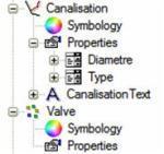
14 XML Feature Modeling (XFM) XML Metadata Driven GIS Features Properties Domain lists, default values Property based symbology Property based annotation Relationships Placement and editing rules Operations and methods Other behaviors Message propagation rules User interface GeoSpatial Administrator XFM Schema Bentley Map Extensible Enforces user standards Easy to implement without programming geographic objects 14


15 Interoperability with Oracle Spatial Other GIS Systems Compliant with Oracle Spatial Any PL/SQL Client Bentley Map via Two-Tier Direct Connection Bentley Geospatial Server Bentley Industry Applications via Two-Tier Direct Connection Bentley Map Enterprise Connection Bentley Industry Applications Enterprise Connection 15
16 Demo: Bentley Map XFM Oracle Spatial Editing Feature Modeling Demonstration 16
17 Demo: Bentley Map- Polygon split and merge Splits and merges polygon features Handles attributes based on user defined rules Copies all properties in absence of any defined rules Demonstration 17
18 Demo: Bentley Map- Publish to i-model i-model is a DGN with geometry and attributes understood by all MicroStation based applications The cross-bentley applications interoperability currency Demonstration 18
19 Bentley Descartes
20 Why Descartes? Because your work requires Editing raster based maps (Full Color) or plans (Black/White) Geo-referencing scanned plans/older maps Viewing Oracle Spatial GeoRaster Viewing Raster DEM with visualization Editing 3D oriented images (e.g.: building textures) Converting raster into vector or converting vector into raster Creating raster scene(s) using any data (vector, raster) Creating image mosaics 20
21 Top Features Viewing of Oracle Spatial Georaster Viewing of Raster DEM Binary Raster Editing (ala I/RAS B) Color Raster Editing Snap on raster content 3D Texture Editing (e.g.: 3D building texture) 21
22 Top Features Image Processing Raster Geo- Referencing/Warping Persistent coordinate system transformation Raster Mosaic Creation Raster Scene Creator Raster to Vector conversion and Vector to Raster conversion Convert Raster Text to Vector Text (OCR) 22

23 Viewing of Oracle Spatial GeoRaster Extremely fast viewing of GeoRaster Querying GeoRaster by attributes and/or spatially Viewing GeoRaster as Raster DEM Demonstration 23
 Oracle Spatial GeoRaster GeoTiff (*.tif) Tag Image File (*.tif) Internet Tiff (*.itiff) Internet Tiff 64 bit (*.itiff64) USGS DEM (*.dem) USGS SDTS (*.catd.")
24 Viewing of Raster DEM Allows viewing Raster DEM Allows applying multiple filtering Elevation, Slope, Aspect Supports multiple formats Erdas image (*.img) Oracle Spatial GeoRaster GeoTiff (*.tif) Tag Image File (*.tif) Internet Tiff (*.itiff) Internet Tiff 64 bit (*.itiff64) USGS DEM (*.dem) USGS SDTS (*.catd.ddf) Demonstration 24


25 Bentley Descartes Value Proposition View Edit All your Raster Data Transform/Geo- Reference Process 25
26 Geo Web Publisher
27 Why Geo Web Publisher? Because you need to Make data available to a wide audience Because you need to share 3D city data with citizens, mayor, city council, managers Integrate with many data types in a single portal Deliver GIS tools to casual users Allow Web GIS users to create reports, prints, etc. from Web GIS applications Create and maintain Web GIS applications, be able to rapidly meet Web users needs Integrate GIS and mapping data with other enterprise wide systems 27
28 What is Geo Web Publisher? It is a Web GIS Easy to implement, high performance Brings together multiple data sources, and databases Supports collaboration workflows OGC compliant, WMS/WFS server Advanced tools for GIS Web applications creation and administration End user tools for map navigation, querying, analysis, reporting, redlining, editing 28
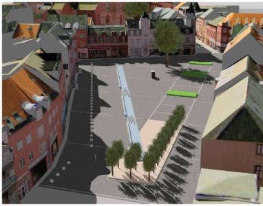
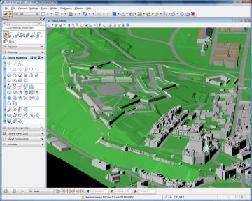
29 Top Features Multi data sources input support DGN/DGN XFM with full fidelity Oracle spatial Geometry, valid time and history, GeoRaster Live or pre-published for optimal performance Raster WMS Database SHP MapInfo Files can be stored in ProjectWise 29
30 Top Features End users GIS tools Searching Reporting Thematic mapping Pie charts Redlining Light editing (Oracle Spatial) Edit ODBC Database attributes Cartographic printing Data Server WMS, WFS, Google Earth 30

 31 WWW.")
31 Top Features Public Web Services for rapid integration with non- Bentley applications Silverlight WMS Support Projections, multiple coordinate systems publishing Web application creation (low cost of ownership) 31


32 Value proposition Data Integration Web GIS Databases Map Server Geospatial Web tools OGC WFS Rapid Deployment Google Earth OGC WMS 32
33 Demo: Bentley Geo Web Publisher Reporting Redline map Query area Query properties Print report Demonstration 33
34 3D City GIS

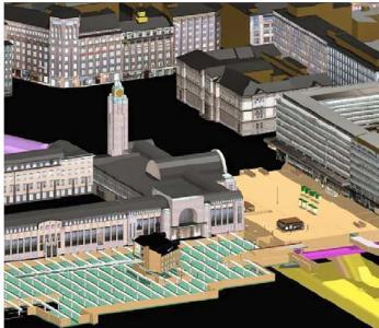


35 3D City GIS Noise Simulation Urban Planning Shadow Analysis Bentley 3D City GIS 3D Analysis and Design Natural Disaster Mitigation Public Relationship Management 35

36 Components of a 3D City GIS 36
37 Bentley Map in 3D City The central piece of any Bentley 3D City GIS 3D Data Creation tool Model and edit smart 3D Objects Work with Oracle Spatial 3D 3D Data Analysis tool Produce 3D thematic maps Review attributes, produce reports 3D Development platform For cities For data producers 37
38 Demo: Bentley Map 3D Oracle Spatial View Oracle Spatial 3D data Query streets and terrain Thematic mapping Overlay with zoning areas and defined height limits Data provided by Quebec City, Canada Demonstration 38
39 Demo: Bentley Map 3D Oracle Spatial Sketch a new building Post to Oracle Modify the building Post to Oracle Data provided by Quebec City, Canada Demonstration 39
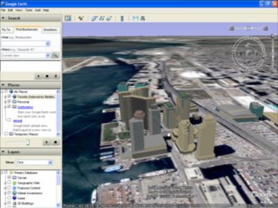
40 Demo: Bentley Geo Web Publisher Google Earth View 3D City model in Google Earth Model is tiled and served by Bentley Geo Web Publisher Demonstration 40
41 Geospatial Server
42 Why Geospatial Server? Because you need to Manage huge volumes of heterogeneous data (GIS data, document, images, projections, ) Easily find the data you own about a given location on earth Know if the data you are about to work with is the latest and greatest or not Make sure that colleagues have access to the data they need to perform their tasks, no less, no more Edit information in spatial databases using a disconnected/long transaction workflow 42
43 What is the Bentley Geospatial Server? A portfolio of the following products: ProjectWise Integration Server ProjectWise Geospatial Management Module ProjectWise Connector for Oracle ProjectWise InterPlot Server Integrated for geospatial needs Five Services: Document Service Spatial Indexing/Searching Service Workflow Management Service Spatial Database Service Plotting Service Can add ProjectWise Connector for ArcGIS as an option 43


44 Data The Bentley Geospatial Server Way Spatial RDBMS Time Line 44
45 Top Features Oracle Spatial Live transactional editing Disconnected transactional editing History and valid time Oracle GeoRaster Oracle Spatial 3D Editing Design Link support 45
46 Top Features Advanced Background Maps (streamed CAD/raster maps, GIS layers, spatial database layers, WMS) Spatial Locations/Spatial Search GIS Types Support: ESRI Personal Geodatabase Support ESRI Shapefile MapInfo TAB MapInfo MIF/MID MapInfo WOR 46
47 Top Features idesktop for: MapInfo ESRI ArcMap DGN/XFM Feature Component Indexing Geocoding by attributes Linear Referencing Batch plotting 47
48 Demo: Bentley Geospatial Server- Oracle Spatial Georaster Extract Oracle Spatial Geometry and GeoRaster Edit in Bentley Map Add Design Links (ProjectWise and URL) Post to Oracle Spatial Demonstration 48
49 Demo: Bentley Geospatial ServeriDesktop for MapInfo Load MapInfo TAB file in Geospatial Server Open MapInfo Tab from Geospatial Server Demonstration 49


50 Value proposition Manage Edit Index Plot Geospatial information Find Archive Organize 50
51 Questions? 51
Bentley Map Advancing GIS for the World s Infrastructure
 Bentley Map Advancing GIS for the World s Infrastructure Presentation Overview Why would you need Bentley Map? What is Bentley Map? Where is Bentley Map Used? Red text signifies new things in Bentley Map
Bentley Map Advancing GIS for the World s Infrastructure
 Bentley Map Advancing GIS for the World s Infrastructure Presentation Overview Why would you need Bentley Map? What is Bentley Map? Where is Bentley Map Used? Why would you need Bentley Map? Because your
Bentley Map V8i (SELECTseries 3)
") Bentley Map V8i (SELECTseries 3) A quick overview Why Bentley Map Viewing and editing of geospatial data from file based GIS formats, spatial databases and raster Assembling geospatial/non-geospatial data
Bentley Map V8i (SELECTseries 3) A quick overview Why Bentley Map Viewing and editing of geospatial data from file based GIS formats, spatial databases and raster Assembling geospatial/non-geospatial data
Bentley Geospatial update
 Bentley Geospatial update Tallinna, 01.11.2007 Timo Tuukkanen, Bentley Systems Issues today Bentley Map available now detailed introduction to Bentley Map Bentley Geo Web Publisher Bentley Web GIS update,
From Geographics Stella to Bentley Map Stella Map. Kimmo Soukki, Account Manager Bentley Finland
 From Geographics Stella to Bentley Map Stella Map Kimmo Soukki, Account Manager Bentley Finland This presentation Stella? Why migrate? New Bentley Stella Map - How it is done? Data migration Bonuses? What
E14- Integrating Civil Design, Mapping and Geospatial Data
 www.bentley.com E14- Integrating Civil Design, Mapping and Geospatial Data Lisa Whitson, Transportation and Local Infrastructure Professional Services, Bentley Systems USA GIS and Engineering Data Integration
These modules are covered with a brief information and practical in ArcGIS Software and open source software also like QGIS, ILWIS.
 Online GIS Training and training modules covered are: 1. ArcGIS, Analysis, Fundamentals and Implementation 2. ArcGIS Web Data Sharing 3. ArcGIS for Desktop 4. ArcGIS for Server These modules are covered
Innovation. The Push and Pull at ESRI. September Kevin Daugherty Cadastral/Land Records Industry Solutions Manager
 Innovation The Push and Pull at ESRI September 2004 Kevin Daugherty Cadastral/Land Records Industry Solutions Manager The Push and The Pull The Push is the information technology that drives research and
May 2011 Oracle Spatial User Conference
 May 2011 Oracle Spatial User Conference Oracle Spatial User Conference! May 19, 2011 Ronald Reagan Building and International Trade Center Washington, DC USA May 2011 Oracle Spatial User Conference Francois
Data Aggregation with InfraWorks and ArcGIS for Visualization, Analysis, and Planning
 Data Aggregation with InfraWorks and ArcGIS for Visualization, Analysis, and Planning Stephen Brockwell President, Brockwell IT Consulting, Inc. Join the conversation #AU2017 KEYWORD Class Summary Silos
Performing Advanced Cartography with Esri Production Mapping
 Esri International User Conference San Diego, California Technical Workshops July 25, 2012 Performing Advanced Cartography with Esri Production Mapping Tania Pal & Madhura Phaterpekar Agenda Outline generic
Esri UC2013. Technical Workshop.
 Esri International User Conference San Diego, California Technical Workshops July 9, 2013 CAD: Introduction to using CAD Data in ArcGIS Jeff Reinhart & Phil Sanchez Agenda Overview of ArcGIS CAD Support
Experiences and Directions in National Portals"
 FIG Seminar on e-land Administration Innsbruck/Austria 2-4 June 2004 "ESRI's Experiences and Directions in National Portals" Kevin Daugherty Cadastral/Land Records Manager ESRI Topic Points Technology
Geodatabase Management Pathway
 Geodatabase Management Pathway Table of Contents ArcGIS Desktop II: Tools and Functionality 3 ArcGIS Desktop III: GIS Workflows and Analysis 6 Building Geodatabases 8 Data Management in the Multiuser Geodatabase
Features and Benefits
 Autodesk LandXplorer Features and Benefits Use the Autodesk LandXplorer software family to help improve decision making, lower costs, view and share changes, and avoid the expense of creating physical
The File Geodatabase API. Craig Gillgrass Lance Shipman
 The File Geodatabase API Craig Gillgrass Lance Shipman Schedule Cell phones and pagers Please complete the session survey we take your feedback very seriously! Overview File Geodatabase API - Introduction
ESRI Quality Solution
 ESRI Quality Solution Paul Hardy Business Development Consultant (NMCAs) ESRI Europe phardy@esri.com ESRI Quality Solution Geodatabase Integrity Schema constraints (Attribute Domains etc) Rich data types
Performing Map Cartography. using Esri Production Mapping
 AGENDA Performing Map Cartography Presentation Title using Esri Production Mapping Name of Speaker Company Name Kannan Jayaraman Agenda Introduction What s New in ArcGIS 10.1 ESRI Production Mapping Mapping
Geodatabase Best Practices. Dave Crawford Erik Hoel
 Geodatabase Best Practices Dave Crawford Erik Hoel Geodatabase best practices - outline Geodatabase creation Data ownership Data model Data configuration Geodatabase behaviors Data integrity and validation
UNIT 4: USING ArcGIS. Instructor: Emmanuel K. Appiah-Adjei (PhD) Department of Geological Engineering KNUST, Kumasi
 Department of Geological Engineering KNUST, Kumasi") UNIT 4: USING ArcGIS Instructor: Emmanuel K. Appiah-Adjei (PhD) Department of Geological Engineering KNUST, Kumasi Getting to Know ArcGIS ArcGIS is an integrated collection of GIS software products ArcGIS
UNIT 4: USING ArcGIS Instructor: Emmanuel K. Appiah-Adjei (PhD) Department of Geological Engineering KNUST, Kumasi Getting to Know ArcGIS ArcGIS is an integrated collection of GIS software products ArcGIS
Using CAD data in ArcGIS
 Using CAD data in ArcGIS Phil Sanchez and Jeff Reinhart Esri UC 2014 Technical Workshop Agenda Overview of ArcGIS CAD Support Using CAD Datasets in ArcMap Georeferencing CAD data for ArcGIS Loading CAD
CAD: Introduction to using CAD Data in ArcGIS. Kyle Williams & Jeff Reinhart
 CAD: Introduction to using CAD Data in ArcGIS Kyle Williams & Jeff Reinhart What we will accomplish today Overview of ArcGIS CAD Support Georeferencing CAD data for ArcGIS How Mapping Specification for
3D City GIS. Agenda. Why 3D City GIS? What does 3D City GIS mean?
 3D City GIS 1 of 60 WWW.BENTLEY.COM Ben Fredericque, Product Manager, Geospatial Agenda Why 3D City GIS? What does 3D City GIS mean? 2 of 60 WWW.BENTLEY.COM Sydney, Australia, 11 16 April 2010 1 Why 3D
ESRI Survey Summit August Clint Brown Director of ESRI Software Products
 ESRI Survey Summit August 2006 Clint Brown Director of ESRI Software Products Cadastral Fabric How does Cadastral fit with Survey? Surveyors process raw field observations Survey measurements define high-order
DP Project Development Pvt. Ltd.
 Dear Sir/Madam, Greetings!!! Thanks for contacting DP Project Development for your training requirement. DP Project Development is leading professional training provider in GIS technologies and GIS application
Discovery and Access of Geospatial Resources using the Geoportal Extension. Marten Hogeweg Geoportal Extension Product Manager
 Discovery and Access of Geospatial Resources using the Geoportal Extension Marten Hogeweg Geoportal Extension Product Manager DISCOVERY AND ACCESS USING THE GEOPORTAL EXTENSION Geospatial Data Is Very
ArcGIS Pro: Essential Workflows STUDENT EDITION
 ArcGIS Pro: Essential Workflows STUDENT EDITION Copyright 2018 Esri All rights reserved. Course version 6.0. Version release date August 2018. Printed in the United States of America. The information contained
Web GIS Deployment for Administrators. Vanessa Ramirez Solution Engineer, Natural Resources, Esri
 Web GIS Deployment for Administrators Vanessa Ramirez Solution Engineer, Natural Resources, Esri Agenda Web GIS Concepts Web GIS Deployment Patterns Components of an On-Premises Web GIS Federation of Server
EnvSci 360 Computer and Analytical Cartography
 EnvSci 360 Computer and Analytical Cartography Lecture 7 Mapping Images, Surfaces, and 3-D Data Brief Overview of Imagery What is Imagery? A spatial data model that defines space as an array of equally
A Geographer s role in a Google Maps World. Jeremy Bartley ESRI
 A Geographer s role in a Google Maps World Jeremy Bartley ESRI 1 It is a good time to be a Geographer. 2 Microsoft, Google, Yahoo, and others are pushing geographic awareness to the general public Providing
Regione Umbria. ESRI EMEA User Conference 2010 Rome, October 27th 2010
 Direzione Ambiente, Territorio e Infrastrutture Servizio Informatico/Informativo: geografico, ambientale e territoriale ESRI EMEA User Conference 2010 Rome, October 27th 2010 Arch. Ambra Ciarapica, Dott.
Imagery and the Location-enabled Platform in State and Local Government
 Imagery and the Location-enabled Platform in State and Local Government Fred Limp, Director, CAST Jim Farley, Vice President, Leica Geosystems Oracle Spatial Users Group Denver, March 10, 2005 TM TM Discussion
Working with the Geodatabase
 Working with the Geodatabase Agenda What is the geodatabase? Benefits of the geodatabase Inside the geodatabase Geodatabase rules Demos Additional resources and training Q & A The Geodatabase is the foundation
Administering your Enterprise Geodatabase using Python. Jill Penney
 Administering your Enterprise Geodatabase using Python Jill Penney Assumptions Basic knowledge of python Basic knowledge enterprise geodatabases and workflows You want code Please turn off or silence cell
GIS CONCEPTS ARCGIS METHODS AND. 3 rd Edition, July David M. Theobald, Ph.D. Warner College of Natural Resources Colorado State University
 GIS CONCEPTS AND ARCGIS METHODS 3 rd Edition, July 2007 David M. Theobald, Ph.D. Warner College of Natural Resources Colorado State University Copyright Copyright 2007 by David M. Theobald. All rights
Geodatabase An Introduction
 2013 Esri International User Conference July 8 12, 2013 San Diego, California Technical Workshop Geodatabase An Introduction David Crawford and Jonathan Murphy Session Path The Geodatabase What is it?
ArcGIS Earth for Enterprises DARRON PUSTAM ARCGIS EARTH CHRIS ANDREWS 3D
 ArcGIS Earth for Enterprises DARRON PUSTAM ARCGIS EARTH CHRIS ANDREWS 3D ArcGIS Earth is ArcGIS Earth is a lightweight globe desktop application that helps you explore any part of the world and investigate
Karsten Vennemann, Seattle. QGIS Workshop CUGOS Spring Fling 2015
 Karsten Vennemann, Seattle 2015 a very capable and flexible Desktop GIS QGIS QGIS Karsten Workshop Vennemann, Seattle slide 2 of 13 QGIS - Desktop GIS originally a GIS viewing environment QGIS for the
EEOS 381 -Spatial Databases and GIS Applications
 EEOS 381 -Spatial Databases and GIS Applications Lecture 5 Geodatabases What is a Geodatabase? Geographic Database ESRI-coined term A standard RDBMS that stores and manages geographic data A modern object-relational
Introduction to ArcGIS Server - Creating and Using GIS Services. Mark Ho Instructor Washington, DC
 Introduction to ArcGIS Server - Creating and Using GIS Services Mark Ho Instructor Washington, DC Technical Workshop Road Map Product overview Building server applications GIS services Developer Help resources
ArcGIS Earth an Intro
 ArcGIS Earth an Intro Chris Andrews Product Manager, 3D and ArcGIS Earth Brian Sims 3D Content Lead 3D across the Esri product family ArcGIS Pro 3D Analyst CityEngine ArcGIS for Server ArcGIS Online ArcGIS
Geodatabase: Best Practices. Robert LeClair, Senior Instructor
 Geodatabase: Best Practices Robert LeClair, Senior Instructor Agenda Geodatabase Creation Data Ownership Data Model Data Configuration Geodatabase Behaviors Data Validation Extending Performance Geodatabase
Environmental Systems Research Institute
 Introduction to ArcGIS ESRI Environmental Systems Research Institute Redlands, California 2 ESRI GIS Development Arc/Info (coverage model) Versions 1-7 from 1980 1999 Arc Macro Language (AML) ArcView (shapefile
Leveraging Web GIS: An Introduction to the ArcGIS portal
 Leveraging Web GIS: An Introduction to the ArcGIS portal Derek Law Product Management DLaw@esri.com Agenda Web GIS pattern Product overview Installation and deployment Configuration options Security options
Spatial Data Analysis with ArcGIS Desktop: From Basic to Advance
 Spatial Data Analysis with ArcGIS Desktop: From Basic to Advance 1. Course overview Modern environmental, energy as well as resource modeling and planning require huge amount of geographically located
Introduction to ArcGIS Server Development
 Introduction to ArcGIS Server Development Kevin Deege,, Rob Burke, Kelly Hutchins, and Sathya Prasad ESRI Developer Summit 2008 1 Schedule Introduction to ArcGIS Server Rob and Kevin Questions Break 2:15
Safe to Save? Archive Options for Geodatabases. Jeff Essic North Carolina State University Libraries
 Safe to Save? Archive Options for Geodatabases Jeff Essic North Carolina State University Libraries 2011 ESRI International Users Conference July 13, 2011 GeoMAPP Geospatial Multistate Archive and Preservation
Implementing INSPIRE Geoportal in Turkey
 Implementing INSPIRE Geoportal in Turkey Gencay SERTER City and Regional Planner 1 Presentation Plan Introduction INSPIRE and Turkey Importance of al Spatial Planning Portal Logical&Legal Hierarchy GeoPortal
Geodatabase Essentials Part One - Intro to the Geodatabase. Jonathan Murphy Colin Zwicker
 Geodatabase Essentials Part One - Intro to the Geodatabase Jonathan Murphy Colin Zwicker Session Path The Geodatabase - What is it? - Why use it? - What types are there? Inside the Geodatabase Advanced
GIS CONCEPTS ARCGIS METHODS AND. 2 nd Edition, July David M. Theobald, Ph.D. Natural Resource Ecology Laboratory Colorado State University
 GIS CONCEPTS AND ARCGIS METHODS 2 nd Edition, July 2005 David M. Theobald, Ph.D. Natural Resource Ecology Laboratory Colorado State University Copyright Copyright 2005 by David M. Theobald. All rights
Exelis and Esri Technologies for Defense and National Security. Cherie Muleh
 Exelis and Esri Technologies for Defense and National Security Cherie Muleh Cherie.Muleh@exelisinc.com ENVI IMAGERY AND DATA BECOME KNOWLEDGE > Add information from imagery to your GIS > Automated workflows
GIS Data Production and Editing Pathway
 GIS Data Production and Editing Pathway Table of Contents ArcGIS Desktop II: Tools and Functionality 3 ArcGIS Desktop III: GIS Workflows and Analysis 6 Building Geodatabases 8 Creating and Maintaining
ArcGIS. for Server. Understanding our World
 ArcGIS for Server Understanding our World ArcGIS for Server Create, Distribute, and Manage GIS Services You can use ArcGIS for Server to create services from your mapping and geographic information system
Free and Open Source Software for Cadastre and Land Registration : A Hidden Treasure? Gertrude Pieper Espada. Overview
 Free and Open Source Software for Cadastre and Land Registration : A Hidden Treasure? Gertrude Pieper Espada Overview FLOSS concepts Digital Land Administration systems FLOSS Database alternatives FLOSS
Portal for ArcGIS: An Introduction. Catherine Hynes and Derek Law
 Portal for ArcGIS: An Introduction Catherine Hynes and Derek Law Agenda Web GIS pattern Product overview Installation and deployment Configuration options Security options and groups Portal for ArcGIS
gvsig a real tool for GIS technicians
 gvsig a real tool for GIS technicians Jorge Gaspar Sanz Salinas jsanz@prodevelop.es International Geodetic Students Meeting 05/05/08 Valencia Agenda of the project OK, but what can gvsig do for me now?
ISO Series Standards in a Model Driven Architecture for Landmanagement. Jürgen Ebbinghaus, AED-SICAD
 ISO 19100 Series Standards in a Model Driven Architecture for Landmanagement Jürgen Ebbinghaus, AED-SICAD 29.10.2003 The Company 100% SIEMENS PTD SIEMENS Business Services Shareholder & Strategic Business
Existing Open Source Tools and Possibilities for Cadastre Systems
 Existing Open Source Tools and Possibilities for Cadastre Systems Gertrude Pieper Espada FIG Congress Sydney, 11-16 April 2010 What is FLOSS? What is open source? What open source software tools are available?
Overview. Everywhere. Over everything.
 Cadenza Desktop Cadenza Web Cadenza Mobile Cadenza Overview. Everywhere. Over everything. The ultimate GIS and reporting suite. Provide, analyze and report data efficiently. For desktop, web and mobile.
One platform for desktop, web and mobile
 One platform for desktop, web and mobile Search and filter Get access to all data thematically filter data in context factually and spatially as well as display it dynamically. Export a selection or send
Among various open-source GIS programs, QGIS can be the best suitable option which can be used across partners for reasons outlined below.
 Comparison of Geographic Information Systems (GIS) software As of January 2018, WHO has reached an agreement with ESRI (an international supplier of GIS software) for an unlimited use of ArcGIS Desktop
Census Mapping with ArcGIS
 Census Mapping with ArcGIS Jin Lee, GIS manager at the Lewis Mumford Center and Center for Social and Demographic Analysis Email: jwlee@albany.edu Phone: 442-5402 Quick summary of Day1 http://csda.albany.edu/events-news/gisworkshop_outline_fall_3-1.pdf
Leveraging the OGC Capabilities of ArcGIS Server
 Leveraging the OGC Capabilities of ArcGIS Server Satish Sankaran Interoperability and Standards Team Yingqi Tang Server Team Jessica Parteno Geodatabase Team ArcGIS Server is Open & Interoperable Using
Migrating Defense Workflows from ArcMap to ArcGIS Pro. Renee Bernstein and Jared Sellers
 Migrating Defense Workflows from ArcMap to ArcGIS Pro Renee Bernstein and Jared Sellers ArcGIS Desktop Desktop Web Device ArcMap ArcCatalog ArcScene ArcGlobe ArcGIS Pro portal Server Online Content and
Canadian Board of Examiners for Professional Surveyors Core Syllabus Item C 5: GEOSPATIAL INFORMATION SYSTEMS
 Study Guide: Canadian Board of Examiners for Professional Surveyors Core Syllabus Item C 5: GEOSPATIAL INFORMATION SYSTEMS This guide presents some study questions with specific referral to the essential
Enabling Web GIS. Dal Hunter Jeff Shaner
 Enabling Web GIS Dal Hunter Jeff Shaner Enabling Web GIS In Your Infrastructure Agenda Quick Overview Web GIS Deployment Server GIS Deployment Security and Identity Management Web GIS Operations Web GIS
Questions and Answers
 AUTODESK LANDXPLORER SOFTWARE FAMILY Questions and Answers The Autodesk LandXplorer 3D city model software family can help you create, analyze, and visualize digital city models. Contents Autodesk Landxplorer
ArcGIS Web Tools, Templates, and Solutions for Defence & Intelligence. Renee Bernstein Esri Solutions Engineer
 ArcGIS Web Tools, Templates, and Solutions for Defence & Intelligence Renee Bernstein Esri Solutions Engineer ArcGIS Solutions Includes 450+ Industry Focused Apps and Capabilities Organized by 9 Primary
GIS Functions and Integration. Tyler Pauley Associate Consultant
 GIS Functions and Integration Tyler Pauley Associate Consultant Contents GIS in AgileAssets products Displaying data within AMS Symbolizing the map display Display on Bing Maps Demo- Displaying a map in
When Map Quality Matters
 When Map Quality Matters 50% 25% Powerful geospatial mapping tools for Adobe Creative Cloud and offline map solutions for mobile devices 20% When Map Quality Matters 10% We re focused on creating powerful
ArcGIS Enterprise: What s New. Philip Heede Shannon Kalisky Melanie Summers Shreyas Shinde
 ArcGIS Enterprise: What s New Philip Heede Shannon Kalisky Melanie Summers Shreyas Shinde ArcGIS Enterprise is the new name for ArcGIS for Server ArcGIS Enterprise Software Components ArcGIS Server Portal
Working with ArcGIS Online
 Esri International User Conference San Diego, CA Technical Workshops July 12, 2011 Working with ArcGIS Online Bern Szukalski, Deane Kensok Topics for this Session ArcGIS Online Overview ArcGIS Online Content
GIS-T 2010 Building a Successful Geospatial Data Sharing Framework: A Ohio DOT Success Story
 GIS-T 2010 Building a Successful Geospatial Data Sharing Framework: A Ohio DOT Success Story ODOT District 2 GIS John Puente District 1 GIS Coordinator\ Planning Administrator 2 Interoperability 3 District
Geoprocessing Tools at ArcGIS 9.2 Desktop
 Geoprocessing Tools at ArcGIS 9.2 Desktop Analysis Tools Analysis Tools \ Extract Clip Analysis Tools \ Extract Select Analysis Tools \ Extract Split Analysis Tools \ Extract Table Select Analysis Tools
Thales Canada, System Division. BattleView: Integrating ArcGIS Into Canadian Army s Command And Control Application
 BattleView: Integrating ArcGIS Into Canadian Army s Command And Control Application BattleView Overview Canadian Army s command and control (C2) application Deployed in army headquarters unit and above
<Insert Picture Here> Oracle Spatial 11g. Dr. Siva Ravada
 Oracle Spatial 11g Dr. Siva Ravada New in Oracle Spatial 11g 3D Support Spatial Web Services Network Data Model GeoRaster Performance Improvements 3D Applications Location-based services
This paper outlines the steps we took to process the repository file into a Geodatabase Utility Data Model for Bloomfield Township s analysis.
 Title of Paper Importing CAD Drawings into a Utility Data Model Authors Names Kevin G. Broecker & James R. Miller Abstract This presentation covers the process needed to integrate data from a CAD drawing
ArcGIS 10.1 An Overview of the System
 ArcGIS 10.1 An Overview of the System ArcGIS 10.1 An Overview of the System Damian Spangrud Director of Solutions, Esri Redlands, CA USA ArcGIS 10.1 Web Cloud Online Mobile Enterprise Desktop ArcGIS 10.1
SOLUTIONS ADVANCED GIS. TekMindz are developing innovative solutions that integrate geographic information with niche business applications.
 ADVANCED GIS SOLUTIONS TekMindz are developing innovative solutions that integrate geographic information with niche business applications. TEK INDZ TM GIS Services Overview At the leading edge of geospatial
Developing An Application For M-GIS To Access Geoserver Through Mobile For Importing Shapefile
 Developing An Application For M-GIS To Access Geoserver Through Mobile For Importing Shapefile Ritik Sharma,A,1, Shubhangi Garg B,2, Yogesh Kumar c,3, Jeevash Mutreja d,4 a ABES Engg.College Ghaziabad
Geodatabase An Overview
 Federal GIS Conference February 9 10, 2015 Washington, DC Geodatabase An Overview Ralph Denkenberger - esri Session Path The Geodatabase - What is it? - Why use it? - What types are there? Inside the Geodatabase
Steve Pietersen Office Telephone No
 Steve Pietersen Steve.Pieterson@durban.gov.za Office Telephone No. 031 311 8655 Overview Why geography matters The power of GIS EWS GIS water stats EWS GIS sanitation stats How to build a GIS system EWS
Paths Toward CAD and GIS Interoperability
 Paths Toward CAD and GIS Interoperability Bo Guo, PhD, PE Gistic Research, Inc Outline CAD and GIS Differences Interoperability Paths UDOT ROW Research Project CAD and GIS: The Difference (I) History Users
Introduction to Geographic Information Systems (GIS): Environmental Science Focus
: Environmental Science Focus") Introduction to Geographic Information Systems (GIS): Environmental Science Focus September 9, 2013 We will begin at 9:10 AM. Login info: Username:!cnrguest Password: gocal_bears Instructor: Domain: CAMPUS
Introduction to Geographic Information Systems (GIS): Environmental Science Focus September 9, 2013 We will begin at 9:10 AM. Login info: Username:!cnrguest Password: gocal_bears Instructor: Domain: CAMPUS
Esri WebGIS Highlights of What s New, and the Road Ahead
 West Virginia GIS Conference WVU, Morgantown, WV Esri WebGIS Highlights of What s New, and the Road Ahead Mark Scott, Solutions Engineer, Esri Local Government Team May 5 th, 2016 West Virginia GIS Conference
Inside the geodatabase
 Inside the geodatabase A map portrays geographic information through a series of thematic overlays streets, buildings, water, terrain, imagery So does a geographic information system (GIS) Each geographic
How does ArcGIS Server integrate into an Enterprise Environment? Willy Lynch Mining Industry Specialist ESRI, Denver, Colorado USA
 How does ArcGIS Server integrate into an Enterprise Environment? Willy Lynch Mining Industry Specialist ESRI, Denver, Colorado USA wlynch@esri.com ArcGIS Server Technology Transfer 1 Agenda Who is ESRI?
Why GIS & Why Internet GIS?
 Why GIS & Why Internet GIS? The Internet bandwagon Internet mapping (e.g., MapQuest) Location-based services Real-time navigation (e.g., traffic) Real-time service dispatch Business Intelligence Spatial
ArcGIS is Advancing. Both Contributing and Integrating many new Innovations. IoT. Smart Mapping. Smart Devices Advanced Analytics
 ArcGIS is Advancing IoT Smart Devices Advanced Analytics Smart Mapping Real-Time Faster Computing Web Services Crowdsourcing Sensor Networks Both Contributing and Integrating many new Innovations ArcGIS
Systems Interoperability at the Port of Long Beach
 Systems Interoperability at the Port of Long Beach Tuesday, June 11, 2013 2:45 pm 4:00 pm, Garden Salon One, 2nd Fl. Presented by: Brien Green, Account Manager, Bentley Systems Daniel Lee, Business Analyst,
Systems Interoperability at the Port of Long Beach
 Systems Interoperability at the Port of Long Beach Tuesday, June 11, 2013 2:45 pm 4:00 pm, Garden Salon One, 2nd Fl. Presented by: Brien Green, Account Manager, Bentley Systems Daniel Lee, Business Analyst,
Geodatabase Programming with Python
 DevSummit DC February 11, 2015 Washington, DC Geodatabase Programming with Python Craig Gillgrass Assumptions Basic knowledge of python Basic knowledge enterprise geodatabases and workflows Please turn
ArcGIS for Desktop. ArcGIS for Desktop is the primary authoring tool for the ArcGIS platform.
 ArcGIS for Desktop ArcGIS for Desktop ArcGIS for Desktop is the primary authoring tool for the ArcGIS platform. Beyond showing your data as points on a map, ArcGIS for Desktop gives you the power to manage
Infrastructure Industry Vertical Solutions and Beyond
 Infrastructure Industry Vertical Solutions and Beyond Chris Bradshaw Vice President Autodesk Investor Day 2005 1 Infrastructure Industry Customers Manage Large, Complex Infrastructure Systems Engineering
A Vision for ArcGIS Applying Geography Everywhere
 A Vision for ArcGIS Applying Geography Everywhere WELCOME PURPOSE A Network of GIS Professionals Are Awakening the World to the Power of Web GIS You Your WORK Making a Difference Your Work Open Maps and
Strategies for Integrating CAD and BIM in ArcGIS. Don Kuehne Esri 3D Product Manager: CAD/BIM/AEC
 Strategies for Integrating CAD and BIM in ArcGIS Don Kuehne Esri 3D Product Manager: CAD/BIM/AEC CAD Digital Drawing CAD in ArcGIS Desktop CAD in Desktop CAD as Data CAD as a Map EXPORT TO CAD Create and
INTRODUCTION TO ARCGIS Version 10.*
 Week 3 INTRODUCTION TO ARCGIS Version 10.* topics of the week Overview of ArcGIS Using ArcCatalog Overview of ArcGIS Desktop ArcGIS Overview Scalable desktop applications ArcView ArcEditor ArcInfo ArcGIS
Introducing ArcGIS Engine
 1 Introducing ArcGIS Engine ESRI ArcGIS Engine is a platform for building custom standalone geographic information system (GIS) applications that support multiple application programming interfaces (APIs),
SDI Standards at work
 SDI Standards at work Jan Juul Jensen Senior Technology Strategist Informi GIS Denmark Informi GIS Private held Limited Company Specialized in GIS 100+ employees HQ in Charlottenlund, Copenhagen Regional
Geodatabase An Introduction
 Federal GIS Conference 2014 February 10 11, 2014 Washington DC Geodatabase An Introduction Ralph Denkenberger esri Session Path The Geodatabase - What is it? - Why use it? - What types are there? Inside