Northwest Association of Networked Ocean Observing Systems The Integrated Ocean Observing System (IOOS) Regional Association for the Pacific NW
|
|
|
- Meghan O’Brien’
- 5 years ago
- Views:
Transcription
 Regional Association for the Pacific NW www.")
1 Northwest Association of Networked Ocean Observing Systems The Integrated Ocean Observing System (IOOS) Regional Association for the Pacific NW
2 U.S. Integrated Ocean Observing System (IOOS) IOOS Vision: A fully integrated ocean observing system to provide service to the Na8on through: improved ecosystem and climate understanding; sustained living marine resources; improved public health and safety; reduced impacts of natural hazards and environmental changes; and enhanced support for marine commerce and transporta8on. IOOS Mission: Lead the integra,on of ocean, coastal, and Great Lakes observing capabili8es, in collabora8on with Federal and non-federal partners, to maximize access to data and genera,on of informa,on products, inform decision making, and promote economic, environmental, and social benefits to our Na>on and the world.

3

4 CONSISTENT NATIONAL CAPABILITY assure Reg. Assn s Leverage and Link engage DIVERSE LOCAL STAKEHOLDERS


5 NANOOS serves the Pacific Northwest Coastal ocean: Northern extent of California Current Winds, topography, freshwater input, ENSO & other climate cycles Major inland basins: Puget Sound-Georgia Basin, Columbia River Urban centers, nearshore development, climate variation Coastal estuaries: Willapa Bay, Grays Harbor, Yaquina Bay, Coos Bay Resource extraction, development, climate Shorelines: Rocky to sandy, dynamic: storms, erosion Winds, development, climate NANOOS Region User Groups: Maritime: shipping, oil transport/spill remediation Fisheries: salmon, shellfish, crab, aquaculture Environmental management: HABs, hypoxia Shoreline: erosion, inundation Hazards: Search and rescue, national security Educators: formal, informal, research Marine recreation: boating, surfing, diving

6 PNW Ocean Observing Systems Design


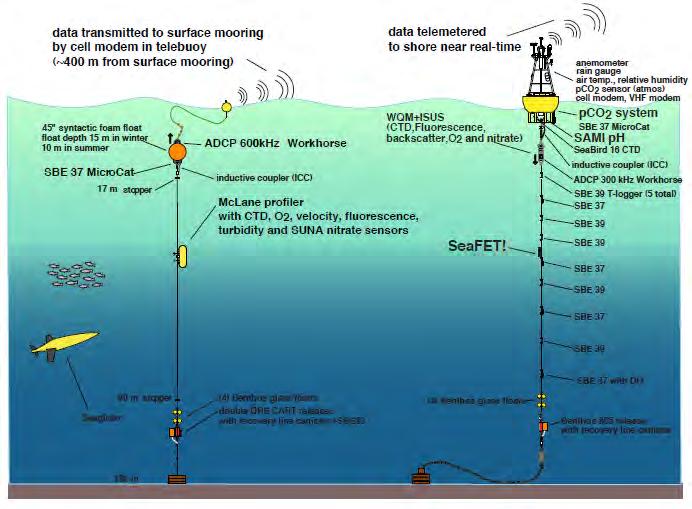
7 A mul,-pla:orm high-resolu,on coastal ocean observing sensor array for researching Washington coastal waters and ecosystem response to climate change. Funded by Murdock Charitable Trust & UW now sustained as part of NANOOS
8

9 UPWELLING WINDS DOWNWELLING WINDS
. URL: h#p://www.psp.wa.gov/psemp/psmarinewatersoverview.php.")
10 BeYer defini8on of Columbia River influence PSEMP Marine Waters Workgroup Puget Sound marine waters: 2014 overview. S. K. Moore, R. Wold, K. Stark, J. Bos, P. Williams, K. Dzinbal, C. Krembs and J. Newton (Eds). URL: h#p://
11 Effort: Observations Modeling/forecasts Data management and communication Tailored user-driven products Outreach Education

12 (All NANOOS assets and data streams) NVS for specific user groups with targeted subsets of the data

13 What are people saying about NANOOS? NANOOS provides critical life safety information to the public, aiding coastal communities to build resiliency. - Jonathan Allan, Coastal Geomorphologist Oregon Department of Geology and Mineral Industries This current generation of shellfish farmer is reliant upon data and services from NANOOS. Checking the NANOOS app before seeding a beach or filling a setting tank has become standard practice. - Margaret Barrette, Pacific Coast Shellfish Growers Association Director Ships crossing the Columbia River Bar face one of the most dangerous harbor entrances in the world. The Columbia River Bar Pilots rely on weather forecasts, real time buoy data along with wave and current models when determining safe times for ships to cross the bar. NANOOS provides an excellent location for us to see and compare all the available data sources. - Captain Dan Jordan, Columbia River Bar Pilots

14 NANOOS focus group to ID what data sets and func,ons shellfish growers need I want it like THIS! Photo: A. Sprenger


15 Pu:ng an IOOS buoy in the water is like pu:ng headlights on a car. It lets us see changing water condicons in real Cme, says Mark Wiegardt, co-owner of Whiskey Creek Shellfish Hatchery.


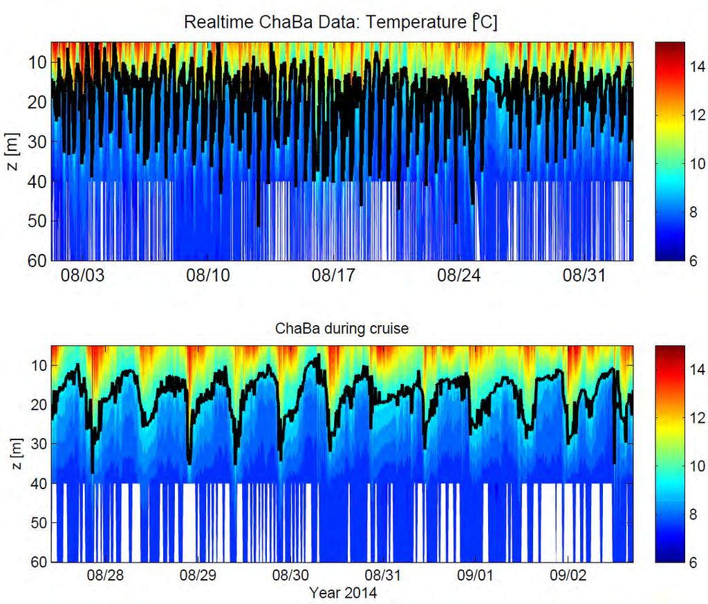
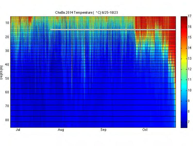
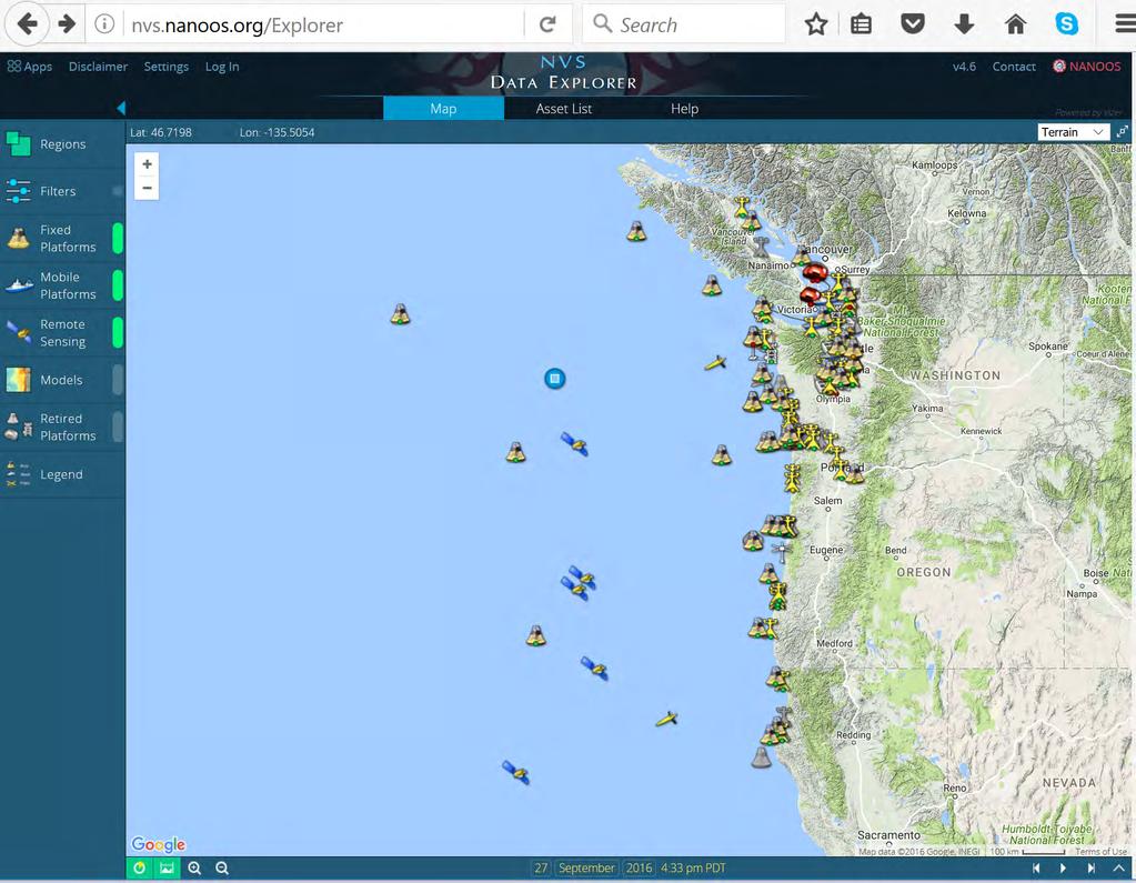
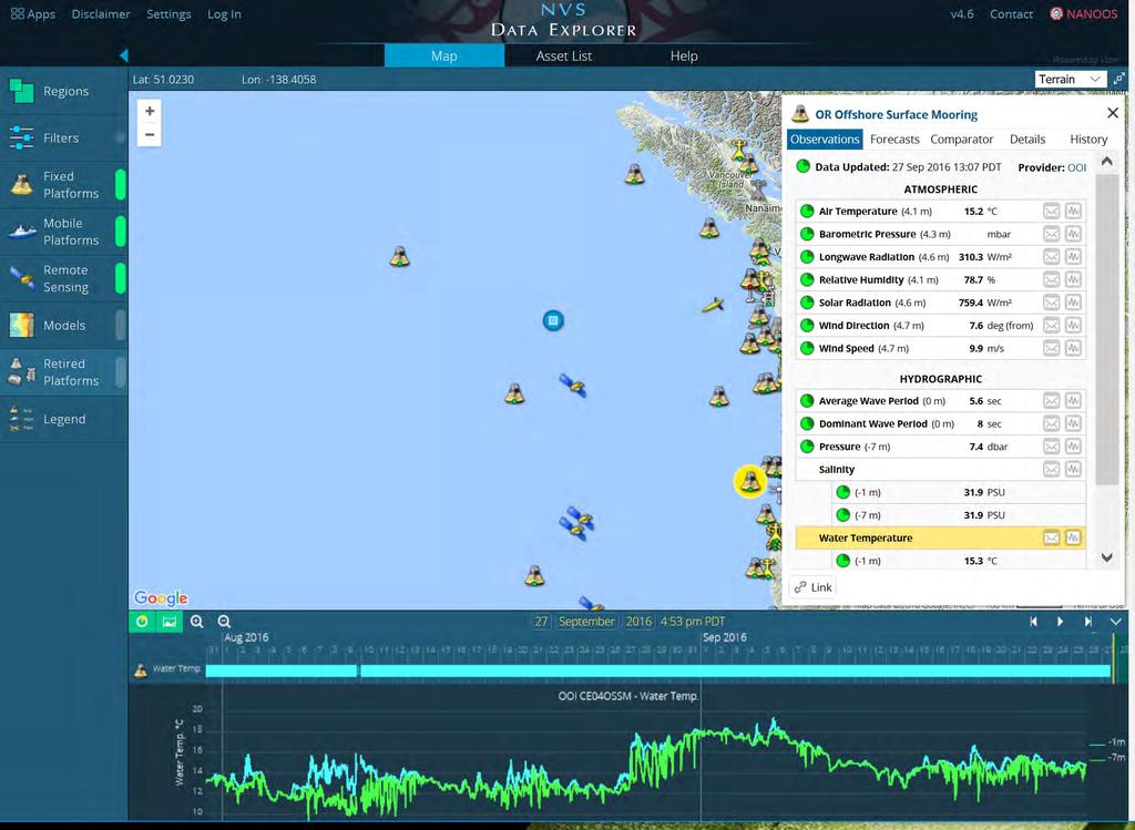
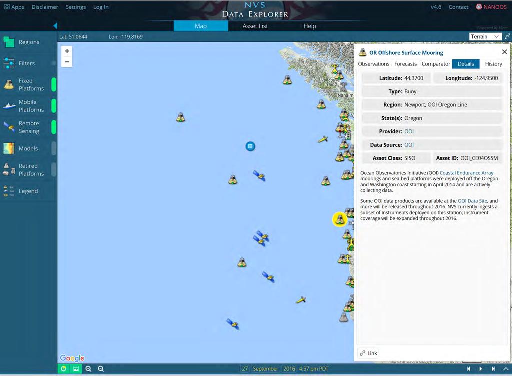
16 Useful tools from NANOOS data portal, the NANOOS Visualization System (NVS) The NVS Data Explorer serves hydrographic and atmospheric data from fixed and mobile platforms, satellite imagery, and computer models to provide realtime conditions and forecasts. The specialized NVS Shellfish Growers app provides real-time ph, pco 2, oxygen, salinity, temperature, and other data, allowing for better management and decision making for the shellfish industry, tribes, and state managers.
17
18
19
20
21

22 NANOOS observa8ons and data
 and present-day departures from average (anomaly).")

 species and domoic acid")

23 Recent Advances in NANOOS Visualizing Climatologies The NVS Climatology app provides users with a rich interface of long-term average conditions (climatology) and present-day departures from average (anomaly). Data visualizations are from buoys, satellites, and weather stations in the Pacific Northwest, enabling users to compare current conditions against conditions measured in the past. NANOOS hosted a Pacific Anomalies 2 Workshop Measuring HABs Remotely The IOOS-supported "Environmental Sample Processor was deployed off La Push at our NEMO buoy and is relaying data on harmful algal bloom (HAB) species and domoic acid toxin concentration through the NVS portal. Having the NANOOS automated HAB sampler, with toxin assessment capability gives tribes the forewarning they need to adjust sampling protocols and better protect the health of coastal residents, tribal and nontribal. - Joe Schumacker, Quinault Indian Nation Mickett (UW), Moore (NOAA) et al.
24 Partnerships with federal, academic, state, industry partners

25 Cha ba is a na8onal OA buoy

26 NOAA-UW-NANOOS Simone Alin, 2016
27 27

28 28 Wind ph


29 WA OA Center: Parker MacCready, Samantha Siedlecki, UW Near-term predictions of OA in Washington 3-Day forecast appears daily on NANOOS

30 Breaking ground to seasonal ecosystem forecas8ng: hypoxia, OA, sardines NOAA FATE: Siedlecki et al., UW


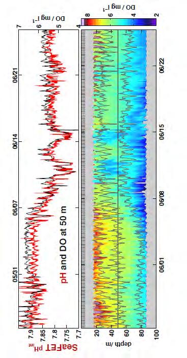
31 WA OA Center monitoring: bioindicator Pteropod shells show signs of dissolu8on PaYerns in 8me and space help us understand impacts and drivers La Push, coastal WA Whidbey basin, Puget Sound Photos: Johnson & Bednarsek

32 The GOA-ON interac,ve data portal Featuring global OA data, asset inventory, metadata, data synthesis products, etc.
33 The GOA-ON interac,ve data portal

34 complex area
HAB Forecaster. For info on HABs in the Pacific Northwest see:
 HAB Forecaster BACKGROUND In this activity, students can take on the role as a resource manager or scientist, tasked with deciding if razor clam harvesters should go out onto the beach to harvest razor
Observation system for early warning of HAB events
 Observation system for early warning of HAB events Vera L. Trainer, NOAA Fisheries Northwest Fisheries Science Center Marine Biotoxins Program Seattle, Washington, USA Juan de Fuca eddy Regional HAB OOS
How typical are current conditions?
 How typical are current conditions? NANOOS provides many sources of information for those wanting to track oceanographic conditions throughout the NE Pacific Ocean to be able to understand if the current
12/2/15. Providing observa.ons, data and informa.on products to meet agency and stakeholder needs
 12/2/15 Providing observa.ons, data and informa.on products to meet agency and stakeholder needs 1 Part of the Integrated Ocean Observing System (IOOS) Governed through a Memorandum of Agreement Fiscal
Alaska Ocean Observing System 101 Anchorage, Alaska
 Alaska Ocean Observing System 101 Anchorage, Alaska Molly McCammon, Director Alaska Ocean Observing System (AOOS) A Regional Observing System within the Integrated Ocean Observing System www.aoos.org IOOS
OSU Ocean Observing Center
 OSU Ocean Observing Center and The Ocean Observatories Initiative OSU Retirement Association March 10,19 2016 2 Early Ocean Observations OSU Retirement Association March 10,19 2016 3 No information off
NOAA Surface Weather Program
 NOAA Surface Weather Program Maintenance Decision Support System Stakeholder Meeting #9 Jim O Sullivan NOAA Surface Weather Program Manager NWS Office of Climate, Water, and Weather Services September
Arctic. Ocean Observing Build Out Plan. alaska ocean observing system. March 1, 2013 draft. Tom Van Pelt
 Arctic Ocean Observing Build Out Plan March 1, 2013 draft Tom Van Pelt alaska ocean observing system Tom Van Pelt Why a coastal observing system in the Arctic? The Arctic is booming with increased activity
Presentation Outline. Project Overview. Sea Level Rise Assessment & Decision Tools. Community Engagement. Tina Whitman, Friends of the San Juans
 Healthy Beaches for People & Fish Sea Level Rise Adaptation Tools for San Juan County, WA Tina Whitman & Andrea MacLennan December 10, 2015 Presentation Outline Project Overview Tina Whitman, Friends of
Egypt-NOAA Cooperation: Advancing our Environmental Science, Technology, and Education
 Egypt-NOAA Cooperation: Advancing our Environmental Science, Technology, and Education T. G. Onsager NOAA Space Weather Prediction Center and NWS International Activities Office (one-year detail) Terry.Onsager@noaa.gov
Naturally. Westport... Wet and Wild...
 Westport... Wet and Wild... Naturally A revitalization concept for the City of Westport and Port of Grays Harbor presented by FOGH (Friends of Grays Harbor), Wildlife Forever of Grays Harbor and other
Darren Wright Maritime Services Program Manager Center for Operational Oceanographic Products and Services (CO-OPS)
") Darren Wright Maritime Services Program Manager Center for Operational Oceanographic Products and Services (CO-OPS) Center for Operational Oceanographic Products and Services (CO-OPS) National Water Level
Darren Wright Maritime Services Program Manager Center for Operational Oceanographic Products and Services (CO-OPS) Center for Operational Oceanographic Products and Services (CO-OPS) National Water Level
NOAA Arctic Priorities and Potential Contributions to PPP/YOPP. Randall Dole NOAA Earth System Research Laboratory Physical Sciences Division
 NOAA Arctic Priorities and Potential Contributions to PPP/YOPP Randall Dole NOAA Earth System Research Laboratory Physical Sciences Division 1 NOAA s Arctic Goals Forecast Sea Ice Strengthen Foundational
NOAA/OAR Observing Systems
 NOAA/OAR Observing Systems Dr. Christopher L. Sabine Director NOAA s Pacific Marine Environmental Laboratory Workshop on Hydroclimate Monitoring Systems and Measurement Needs June, 2014 Global Ocean Observing
The Science of Coastal and Marine Spatial Planning A Workshop for Oregon Academic Faculty
 The Science of Coastal and Marine Spatial Planning A Workshop for Oregon Academic Faculty November 29 30, 2011 Oregon State University Lisa DeBruyckere, Coordinator West Coast Governors Agreement on Ocean
Coastal Impacts of Climate Change in the Northwest: A Summary of the Findings of the upcoming National Climate Assessment
 Western Washington University Western CEDAR Salish Sea Ecosystem Conference 2014 Salish Sea Ecosystem Conference (Seattle, Wash.) May 1st, 3:30 PM - 5:00 PM Coastal Impacts of Climate Change in the Northwest:
MARINE SPATIAL PLANNING
 MARINE SPATIAL PLANNING Washington Uses Spatial Planning to Honor its Pacific Coast and Offshore Waters Past, Present and Future The Washington State Pacific Coast and offshore waters are diverse in both
Marine Spatial Planning: A Tool for Implementing Ecosystem-Based Management
 Marine Spatial Planning: A Tool for Implementing Ecosystem-Based Management Steven Murawski, Ph.D., Ecosystem Goal Team Lead National Oceanic and Atmospheric Administration NOAA November 16, 2009 1 To
STAMP Spa)al Tools for Arc)c Mapping & Planning. Creating an interactive data tool to improve access and usability of Arctic data
al Tools for Arc)c Mapping & Planning. Creating an interactive data tool to improve access and usability of Arctic data") STAMP Spa)al Tools for Arc)c Mapping & Planning Creating an interactive data tool to improve access and usability of Arctic data Mission Provide easy access to physical, chemical, and biological data Network
STAMP Spa)al Tools for Arc)c Mapping & Planning Creating an interactive data tool to improve access and usability of Arctic data Mission Provide easy access to physical, chemical, and biological data Network
NOAA s National Ocean Service. Center for Operational Oceanographic Products and Services
 NOAA s National Ocean Service Center for Operational Oceanographic Products and Services Richard Edwing, CO-OPS Acting Director January 27, 2010 Outline CO-OPS Overview Programs Observing Systems PORTS
NOAA West Watch. Reporting Regional Environmental Conditions & Impacts in the West. January 23, 2017
 NOAA West Watch Reporting Regional Environmental Conditions & Impacts in the West January 23, 2017 Call Agenda Project Recap & Updates (Ruth Howell) El Niño and Regional Climate brief (Dan McEvoy) IOOS
Doug Kluck Regional Climate Services Director Kansas City, MO
 Climate Resilience and Information: Opportunities with Tribes and the National Oceanic and Atmospheric Administration (NOAA) and Partners National Congress of American Indians Annual Convention (October
THE USE OF GEOSPATIAL DATA TO SUPPORT VULNERABILITY MAPPING OF THE OREGON COAST. Kelvin Raiford MS Candidate Geography Department of Geosciences
 THE USE OF GEOSPATIAL DATA TO SUPPORT VULNERABILITY MAPPING OF THE OREGON COAST Kelvin Raiford MS Candidate Geography Department of Geosciences INTRODUCTION This study is an outcome of the project Geospatial
Access to IOOS Data Relevant to OOI. Kathleen Bailey NOAA/NOS/IOOS January 6, 2016
 Access to IOOS Data Relevant to OOI Kathleen Bailey NOAA/NOS/IOOS January 6, 2016 The U.S. Integrated Ocean Observing System (IOOS) Federal Regional Satellites 600+: Buoys, Water Level stations, Coastal
ALASKA OCEAN OBSERVING SYSTEM 2016 ANNUAL IMPACT REPORT
 ALASKA OCEAN OBSERVING SYSTEM 2016 ANNUAL IMPACT REPORT 1 ALASKA OCEAN OBSERVING SYSTEM 2016 ANNUAL IMPACT REPORT 2 ALASKA OCEAN OBSERVING SYSTEM 2016 ANNUAL IMPACT REPORT Letter from Executive Director
Data Management for Algal Monitoring in the Gulf of Mexico
 Data Management for Algal Monitoring in the Gulf of Mexico Scott Cross NOAA National Oceanographic Data Center/ Coastal Data Development Center (NCDDC) Outline History Current & Future Directions Needs
Heather Schlosser Army Corps of Engineers Coastal Studies Group August 28, 2008
 Got sand? Regional Sediment Management in Orange County Heather Schlosser Army Corps of Engineers Coastal Studies Group August 28, 2008 Regional Sediment Management Regional sediment management recognizes
Introduction: The Gulf of Mexico Alliance. The Gulf GAME project MERMAid and PHINS Results & Conclusions What s next? Examples
 AAG Las Vegas March 25, 2009 Introduction: Ocean governance and Ecosystem-Based Management The Gulf of Mexico Alliance Habitat Identification and Characterization The Gulf GAME project MERMAid and PHINS
Operational Estuarine & Coastal Forecast Systems in NOAA s. National Ocean Service
 Operational Estuarine & Coastal Forecast Systems in NOAA s. National Ocean Service Eugene Wei, Frank Aikman III and Richard Patchen NOAA S S National Ocean Service Workshop on: Data Assimilation in Support
NOAA S Arctic Program in 2017
 NOAA S Arctic Program in 2017 NOAA s Arctic Mission To determine how the Arctic system is changing on time scales of weeks to decades, particularly with respect to the consequences that the loss of sea
Your eye on Alaska s coasts and oceans
 1 ALASKA OCEAN OBSERVING SYSTEM 2017 ANNUAL IMPACT REPORT Your eye on Alaska s coasts and oceans Alaska ShoreZone 2 Letter from Executive Director 2017 was an exciting year for AOOS as we continue to develop
Spatial Data Availability Energizes Florida s Citizens
 NASCIO 2016 Recognition Awards Nomination Spatial Data Availability Energizes Florida s Citizens State of Florida Agency for State Technology & Department of Environmental Protection Category: ICT Innovations
The known requirements for Arctic climate services
 The known requirements for Arctic climate services based on findings described in STT White paper 8/2015 Johanna Ekman / EC PHORS STT Regional drivers The Arctic region is home to almost four million people
Climate Change Impacts in Alaska: the Weather Perspective
 Climate Change Impacts in Alaska: the Weather Perspective September 18, 2007 NOAA s National Weather Service, Alaska Region James Partain, Chief Environmental and Scientific Services Division NOAA NWS
Regional Environmental Conditions & Impacts Coordination. NOAA West April 25, 2016
 Regional Environmental Conditions & Impacts Coordination NOAA West April 25, 2016 1 Call Agenda Welcome El Niño and Regional Climate brief (D. McEvoy) Climatology Application (NANOOS) CeNCOOS update (D.
Improving Sub-Seasonal to Seasonal Prediction at NOAA
 Improving Sub-Seasonal to Seasonal Prediction at NOAA Dr. Louis W. Uccellini Director, National Weather Service NOAA Assistant Administrator for Weather Services July 13, 2016 Congressional Briefing Value
MERSEA Marine Environment and Security for the European Area
 MERSEA Marine Environment and Security for the European Area Development of a European system for operational monitoring and forecasting of the ocean physics, biogeochemistry, and ecosystems, on global
Marine Spatial Planning Leslie-Ann McGee Battelle Memorial Institute
 Marine Spatial Planning Leslie-Ann McGee Battelle Memorial Institute Rev061708 1 Marine Spatial Planning What is it? Why is it different? Where is it currently being employed? What is happening in the
NOAA West Watch. Reporting Regional Environmental Conditions & Impacts in the West. March 20, 2018
 NOAA West Watch Reporting Regional Environmental Conditions & Impacts in the West March 20, 2018 Call Agenda Project Recap & Updates (Polly Hicks) El Niño and Regional Climate brief (Dan McEvoy) Guest
Drought Impacts in the Southern Great Plains. Mark Shafer University of Oklahoma Norman, OK
 Drought Impacts in the Southern Great Plains Mark Shafer University of Oklahoma Norman, OK Causes of Drought: Large-Scale, Stationary High Pressure Air rotates clockwise around high pressure steers storms
Ellen L. Mecray NOAA Regional Climate Services Director, Eastern Region Taunton, MA
 Ellen L. Mecray NOAA Regional Climate Services Director, Eastern Region Taunton, MA Regions of the US National Climate Assessment What we Observe: Climate changes and impacts Extreme precipitation and
CLIMATE CHANGE ADAPTATION BY MEANS OF PUBLIC PRIVATE PARTNERSHIP TO ESTABLISH EARLY WARNING SYSTEM
 CLIMATE CHANGE ADAPTATION BY MEANS OF PUBLIC PRIVATE PARTNERSHIP TO ESTABLISH EARLY WARNING SYSTEM By: Dr Mamadou Lamine BAH, National Director Direction Nationale de la Meteorologie (DNM), Guinea President,
Western Alaska Buoy Deployment and Data Streaming. Author of Report Molly McCammon, AOOS,
 1. PROJECT INFORMATION Title: Western Alaska Buoy Deployment and Data Streaming Report period December 31, 2012 May 27, 2015 Report submission date May 27, 2015 (rec d 27 May; rev d 27 May; resp d 27 May;
OCEANOGRAPHIC DATA MANAGEMENT
 OCEANOGRAPHIC DATA MANAGEMENT Presented to: Environmental Disaster Data Management Meeting Russ Beard Director, National Coastal Data Development Center Interim Science Coordinator, Gulf Restoration Council
Doug Kluck NOAA Kansas City, MO National Center for Environmental Information (NCEI) National Integrated Drought Information System (NIDIS)
 National Integrated Drought Information System (NIDIS)") National Integrated Drought Information System (NIDIS) for the Missouri River Basin Drought Early Warning Information System (DEWS) & Runoff Trends in the Missouri Basin & Latest Flood Outlook Doug Kluck
National Integrated Drought Information System (NIDIS) for the Missouri River Basin Drought Early Warning Information System (DEWS) & Runoff Trends in the Missouri Basin & Latest Flood Outlook Doug Kluck
NANOOS. Issue 1.1 Safe and efficient commercial shipping and recreational boating.
 BUILD-OUT PLAN FOR NANOOS PART ONE: ISSUES AND PRODUCT TEMPLATES 1. MARINE OPERATIONS Issue 1.1 Safe and efficient commercial shipping and recreational boating. The PNW is a vital hub of maritime transportation
Liana Talaue McManus. Division of Marine Affairs and Policy Rosenstiel School of Marine & Atmospheric Science University of Miami
 Liana Talaue McManus Division of Marine Affairs and Policy Rosenstiel School of Marine & Atmospheric Science University of Miami Outline 1. Coasts as vulnerable & resilient social ecological systems 2.
Serving Marine-Related Users in the Mid-Atlantic through Ocean Observing and Forecasting
 MIDDLE ATLANTIC REGIONAL ASSOCIATION COASTAL OCEAN OBSERVING SYSTEM DC MD 1000 km Cape to Cape PA DE NJ CT RI MA Cape Cod NY 10 States and D.C 111 Congressional Districts Serving Marine-Related Users in
The Blob, El Niño, and the Drought in Puget Sound
 The Blob, El Niño, and the Drought in Puget Sound Christopher Krembs, Marine Monitoring Unit, EAP, Ecology The Drought The Blob El Niño Warmest first four months since 1981, (Source: NASA's Goddard Institute
NOAA Nautical Charts and Coastal and Marine Spatial Planning. Meredith Westington Chief Geographer NOAA/NOS/Office of Coast Survey
 NOAA Nautical Charts and Coastal and Marine Spatial Planning Meredith Westington Chief Geographer NOAA/NOS/Office of Coast Survey Ocean Policy Task Force What is CMSP? A comprehensive, adaptive, integrated,
Advancing Real Time Observations and Coastal Modeling Forecasts-
 Advancing Real Time Observations and Coastal Modeling Forecasts- Moving Forward in a Changing Coastal Landscape Next Generation Navigation-Coastal Operations- Coastal and Nearshore Coastal Operational
Marine Spatial Data for Marine Spatial Planning. Ocean Leadership 2010 Public Policy Forum
 Marine Spatial Data for Marine Spatial Planning Ocean Leadership 2010 Public Policy Forum March 10, 2010 Edward Saade President, Fugro EarthData, Inc 1 Marine Spatial Data What is Marine Spatial Data?
COVERAGE-Sargasso Sea
 COVERAGE-Sargasso Sea A Collaborative Project between NASA and the Sargasso Sea Commission Dr. Vardis Tsontos Dr. Jorge Vazquez NASA Jet Propulsion Laboratory, California Institute of Technology UN-HQ
The Field Research Facility, Duck, NC Warming Ocean Observations and Forecast of Effects
 The Field Research Facility, Duck, NC Warming Ocean Observations and Forecast of Effects A potential consequence of a warming ocean is more frequent and more intense wind events (Hurricanes & Typhoons)
Impact of Climate Change on Chinook Salmon
 Region: Western Coastlines Grade Level(s): 5-8 Impact of Climate Change on Chinook Salmon Time Required: 2-3 class periods Focus Question(s): How will long term climate changes impact northwest Pacific
Coastal Erosion & Climate Change: PRIDE 2005 Towards an Alaska Wind/Wave Climatology
 Coastal Erosion & Climate Change: PRIDE 2005 Towards an Alaska Wind/Wave Climatology 2 nd PRIDE Workshop August 9-10, 2005 David Atkinson, Int l Arctic Research Center, Univ. Of Alaska-Fairbanks James
SAWS: Met-Ocean Data & Infrastructure in Support of Industry, Research & Public Good. South Africa-Norway Science Week, 2016
 SAWS: Met-Ocean Data & Infrastructure in Support of Industry, Research & Public Good South Africa-Norway Science Week, 2016 Marc de Vos, November 2016 South Africa: Context http://learn.mindset.co.za/sites/default/files/resourcelib/e
Coastal Response Research Center. Nancy Kinner University of New Hampshire (UNH) Michele Jacobi NOAA ORR. September 27, 2007
 Michele Jacobi NOAA ORR. September 27, 2007") Coastal Response Research Center Nancy Kinner University of New Hampshire (UNH) Michele Jacobi NOAA ORR September 27, 2007 1 Coastal Response Research Center (CRRC) CRRC is partnership between NOAA s Office
Coastal Response Research Center Nancy Kinner University of New Hampshire (UNH) Michele Jacobi NOAA ORR September 27, 2007 1 Coastal Response Research Center (CRRC) CRRC is partnership between NOAA s Office
Future climate impacts on Puget Sound oceanography: the North Pacific and hydrological context
 Western Washington University Western CEDAR Salish Sea Ecosystem Conference 2014 Salish Sea Ecosystem Conference (Seattle, Wash.) Apr 30th, 1:30 PM - 3:00 PM Future climate impacts on Puget Sound oceanography:
MONITORING THE ATMOSPHERE, OCEAN AND CLIMATE FROM SPACE
 MONITORING THE ATMOSPHERE, OCEAN AND CLIMATE FROM SPACE TRANSFORMING OUR WORLD MONITORING WEATHER AND CLIMATE FROM SPACE MONITORING THE ATMOSPHERE, OCEAN AND CLIMATE FROM SPACE FOR TRANSFORMING OUR WORLD
NGGPS Community Sea Ice Model Recommendation Workshop. Rebecca Heim / Gene Petrescu NOAA/NWS Alaska Region
 NGGPS Community Sea Ice Model Recommendation Workshop Rebecca Heim / Gene Petrescu NOAA/NWS Alaska Region NWS Alaska Region Ice Services Excerpts from NOAAs Arctic Action Plan NOAA s National Weather Service
The Baffin Bay Observing System (BBOS)
") The Baffin Bay Observing System (BBOS) A proposed, innova;ve marine observing network led by a Canadian network in collabora;on with Inuit, EU and USA partners. Designed to examine consequences and impacts
The Baffin Bay Observing System (BBOS) A proposed, innova;ve marine observing network led by a Canadian network in collabora;on with Inuit, EU and USA partners. Designed to examine consequences and impacts
DEPARTMENT OF GEOLOGY AND MINERAL INDUSTRIES WAYS & MEANS SUBCOMMITTEE ON NATURAL RESOURCES MARCH 2, 2017
 DEPARTMENT OF GEOLOGY AND MINERAL INDUSTRIES WAYS & MEANS SUBCOMMITTEE ON NATURAL RESOURCES MARCH 2, 2017 1 ABOUT DOGAMI AGENCY MISSION, VISION & GOALS 2 Lidar image of a stream network along the Umpqua
This table connects the content provided by Education Perfect to the NSW Syllabus.
 Education Perfect Geography provides teachers with a wide range of quality, engaging and innovative content to drive positive student learning outcomes. Designed by teachers and written by our in-house
LIDAR AND BATHYMETRIC REMOTE SENSING APPLICATIONS IN MAPPING COASTAL EROSION YAQUINA HEAD, OREGON
 LIDAR AND BATHYMETRIC REMOTE SENSING APPLICATIONS IN MAPPING COASTAL EROSION YAQUINA HEAD, OREGON By Brooks Adam Hadsall Geography 493/593 Digital Terrain Analysis Photo: Friends of Yaquina Head Lighthouse,
Newsletter # 2. Pilot sites in Greece. December 2018
 A HarmonizEd framework to Mitigate coastal EroSion promoting ICZM protocol implementation Newsletter # 2 December 2018 View of a beach in Ammolofi ( Paggaio Municipality ) Pilot sites in Greece 1. Name
Climate Risk Visualization for Adaptation Planning and Emergency Response
 Climate Risk Visualization for Adaptation Planning and Emergency Response NCR Flood Fact Finding Workshop Ricardo Saavedra ricardo@vizonomy.com Social Media, Mobile, and Big Data St. Peter s Basilica,
Building Institutional Capacity for Multi-Hazard Early Warning in Asia and the Pacific Subtitle
 Building Institutional Capacity for Multi-Hazard Early Warning in Asia and the Pacific Subtitle Title Keran Wang Chief, Space Applications Section ICT and Disaster Risk Reduction Division 22 May 2018 Pillar
USGS National Geospatial Program Understanding User Needs. Dick Vraga National Map Liaison for Federal Agencies July 2015
 + USGS National Geospatial Program Understanding User Needs Dick Vraga National Map Liaison for Federal Agencies July 2015 + Topics 2 Background Communities of Use User Surveys National Map Liaisons Partnerships
Molly McCammon Alaska Ocean Observing System October 15, 2012
 Molly McCammon Alaska Ocean Observing System October 15, 2012 Marine Operations Safe a& efficient shipping & recreational boating, search & rescue, spill response & offshore energy development Weather
Harmful Algal Blooms (HABs) 5 Applications
 5 Applications") Harmful Algal Blooms (HABs) 5 Applications Richard P. Stumpf NOAA, National Ocean Service HAB occurrences worldwide Image from whoi.edu/redtide HAB applications: short term Management: Monitoring and Response
Harmful Algal Blooms (HABs) 5 Applications Richard P. Stumpf NOAA, National Ocean Service HAB occurrences worldwide Image from whoi.edu/redtide HAB applications: short term Management: Monitoring and Response
ICAN Great Lakes Workshop
 Washington Coastal latlas ICAN Great Lakes Workshop September 13 15, 15 2010 Current Washington Coastal Atlas http://www.ecy.wa.gov/programs/sea/sma/atlas_home.html 1 st version of WA Coastal Atlas was
Building Institutional Capacity for Multi-Hazard Early Warning in Pacific Countries Subtitle
 Building Institutional Capacity for Multi-Hazard Early Warning in Pacific Countries Subtitle Title Keran Wang Chief, Space Applications Section ICT and Disaster Risk Reduction Division 30 March 2018 Slide
July 24, 2017 Annapolis, MD Bryan A. Jackson NWS Sterling, VA Marine Program Leader
 When Wicked Weather Strikes Insights into Chesapeake Bay Weather July 24, 2017 Annapolis, MD Bryan A. Jackson NWS Sterling, VA Marine Program Leader Mission of the National Weather Service Provide climate,
West Florida Shelf and Tampa Bay Responses to Hurricane Irma: What Happened and Why
 West Florida Shelf and Tampa Bay Responses to Hurricane Irma: What Happened and Why R.H. Weisberg Y. Liu J. Chen College of Marine Science University of South Florida St. Petersburg, FL SECOORA Webinar
HF radarcontribution to South Africa Blue Economy
 HF radarcontribution to South Africa Blue Economy Anton G Kjelaas1, Andres Alonso- Martirena2, Chad Whelan3 South Africa- Norway Science Week 2016 Oct 31- Nov 4 2016 1 2 3 BLUE ECONOMY Sustainable use
IOOS Regional Associations Collaborations with NOAA's National Weather Service
 IOOS Regional Associations Collaborations with NOAA's National Weather Service Updated October 2011 Most of the 11 IOOS Regional Associations work with the NWS field offices. These collaborations include
Telepresence In The Ocean
 The Ocean Observatories Initiative: Establishing A Sustained And Adaptive Telepresence In The Ocean Shelby Walker (1) (1) National Oceanic and Atmospheric Administration, Office of Oceanic and Atmospheric
NOAA Operational Forecast System Gulf of Mexico, Demonstration since Sep 1999; Operational since Sep 2004:
 NOAA Operational Forecast System Gulf of Mexico, Demonstration since Sep 1999; Operational since Sep 2004: An Operational forecast of impact: 0-3 days and a prediction of likelihood of a bloom for mgmt
US National Spatial Data Infrastructure A Spatial Framework for Governance and Policy Development to Enable a Location-Based Digital Ecosystem
 GeoPlatform Workshop 7 Dec 2016, Department of the Interior Washington, D.C. US National Spatial Infrastructure A Spatial Framework for Governance and Policy Development to Enable a Location-Based Digital
The Southern California Coastal Ocean Observing System SCCOOS. Ocean at your fingertips
 The Southern California Coastal Ocean Observing System SCCOOS Ocean at your fingertips Ivona Cetinic University of Southern California www.sccoos.org Outline Overview Ocean observing systems - general
New NASA Ocean Observations and Coastal Applications
 New NASA Ocean Observations and Coastal Applications Duane Armstrong Chief, Applied Science & Technology Project Office August 20, 2014 1 Outline NASA s new Earth Science Ocean Science Missions for 2014
The National Integrated Drought Information System (NIDIS) Moving the Nation from Reactive to Proactive Drought Risk Management
 Moving the Nation from Reactive to Proactive Drought Risk Management") The National Integrated Drought Information System (NIDIS) Moving the Nation from Reactive to Proactive Drought Risk Management CSG-West Annual Meeting Agriculture & Water Committee Snowbird, UT September
The National Integrated Drought Information System (NIDIS) Moving the Nation from Reactive to Proactive Drought Risk Management CSG-West Annual Meeting Agriculture & Water Committee Snowbird, UT September
Rainfall-River Forecasting: Overview of NOAA s Role, Responsibilities, and Services
 Dr. Thomas Graziano Chief Hydrologic Services Division NWS Headquarters Steve Buan Service Coordination Hydrologist NWS North Central River Forecast Center Rainfall-River Forecasting: Overview of NOAA
CONFERENCE STATEMENT
 CONFERENCE STATEMENT We, the elected representatives from Canada, Denmark/Greenland, Finland, Iceland, Norway, Russia, Sweden and the United States of America; In collaboration with the indigenous peoples
Regional Environmental Conditions & Impacts Coordination. NOAA West March 21, 2016
 Regional Environmental Conditions & Impacts Coordination NOAA West March 21, 2016 Call Agenda Welcome El Niño and Regional Climate brief (D. McEvoy) Climatology Application (NANOOS) Environmental conditions
National Weather Service. Building a Weather Ready Nation
 National Weather Service Building a Weather Ready Nation The NWS is a federal agency Department of Commerce National Oceanic and Atmospheric Administration National Weather Service Today s National Weather
Creating a WeatherSMART nation: SAWS drought related research, services and products
 Creating a WeatherSMART nation: SAWS drought related research, services and products Drought Dialogue 23-24 June 2016 Western Cape Government Hannes Rautenbach South African Weather Service SAWS mandate
Harmful Algal Bloom Detectives in the Gulf of Mexico Satellites, Gliders and Buoys, Oh My!
 Harmful Algal Bloom Detectives in the Gulf of Mexico Satellites, Gliders and Buoys, Oh My! By Chris Simoniello and Ruth Mullins* With information from: *The Gulf of Mexico Coastal Ocean Observing System
Regional Environmental Conditions & Impacts Coordination. NOAA West May 25, 2016
 Regional Environmental Conditions & Impacts Coordination NOAA West May 25, 2016 1 Call Agenda Welcome El Niño and Regional Climate brief (D. McEvoy) Climatology Application (NANOOS) Environmental conditions
ICAN Great Lakes 2010 Workshop
 ICAN Great Lakes 2010 Workshop Chris Cortina Maryland s Chesapeake & Coastal Program MD Department of Natural Resources Maryland s Coastal Atlas: What is it? The Coastal Atlas is an online mapping and
Capturing a Holistic Understanding of a Large Marine Ecosystem The NOAA Gulf of Mexico Data Atlas
 Capturing a Holistic Understanding of a Large Marine Ecosystem The NOAA Gulf of Mexico Data Atlas NODC / National Coastal Data Development Center gulfalas.noaa.gov Need: data that contribute to long-term
NOAA s Regional Climate Science & Information: Opportunities and Challenges
 NOAA s Regional Climate Science & Information: Opportunities and Challenges Dr. Wayne Higgins Climate Program Office, Director Office of Oceanic and Atmospheric Research National Oceanic and Atmospheric
The Ocean Networks Canada Observatory Science, Industry and Society
 The Ocean Networks Canada Observatory Science, Industry and Society S. Martin Taylor President and CEO, Ocean Networks Canada (www.oceannetworks.ca) May 31st, 2012 Global challenges of ocean events, processes
The Coastal Field Data Collection Program (CFDC) Waves & Coastal Observations for the Corps and the Nation
 Waves & Coastal Observations for the Corps and the Nation") The Coastal Field Data Collection Program (CFDC) Waves & Coastal Observations for the Corps and the Nation Bill Birkemeier Program Manager William.Birkemeier@usace.army.mil 10 August 2010 US Army Corps
The Coastal Field Data Collection Program (CFDC) Waves & Coastal Observations for the Corps and the Nation Bill Birkemeier Program Manager William.Birkemeier@usace.army.mil 10 August 2010 US Army Corps
Proper Data Management Responsibilities to Meet the Global Ocean Observing System (GOOS) Requirements
 Requirements") Data Buoy Cooperation Panel XXVI Oban, Scotland, UK 27 September 2010 Proper Data Management Responsibilities to Meet the Global Ocean Observing System (GOOS) Requirements William Burnett Data Management
Data Buoy Cooperation Panel XXVI Oban, Scotland, UK 27 September 2010 Proper Data Management Responsibilities to Meet the Global Ocean Observing System (GOOS) Requirements William Burnett Data Management
Catalysing Innovation in Weather Science - the role of observations and NWP in the World Weather Research Programme
 Catalysing Innovation in Weather Science - the role of observations and NWP in the World Weather Research Programme Estelle de Coning, Paolo Ruti, Julia Keller World Weather Research Division The World
PART I - PROJECT IDENTIFICATION INFORMATION PART II - DOCUMENTATION
 No students reported this period Progress Report Project Update Report Reporting Period: 2/1/2014-1/31/2015 MIT Sea Grant College Program E38-300 292 Main Street, Cambridge, MA 02139 (617) 253-9305 PART
Overview of Methods. Terrestrial areas that are most important for conservation Conservation
 Overview of Methods The goal of the Western Lake Erie Coastal Conservation Vision project (WLECCV) is to define where we should be working locally to optimally achieve regional conservation impact. The
Leveraging Existing and Future In-Situ Observational Networks
 Leveraging Existing and Future In-Situ Observational Networks John Horel* Department of Atmospheric Sciences University of Utah john.horel@utah.edu * COI Disclosure: equity stake in Synoptic Data Corp.