Harmful Algal Bloom Detectives in the Gulf of Mexico Satellites, Gliders and Buoys, Oh My!
|
|
|
- Louisa Morgan
- 5 years ago
- Views:
Transcription

1

 Mote Marine Lab (G.J. Kirkpatrick, B.A.")
2 Harmful Algal Bloom Detectives in the Gulf of Mexico Satellites, Gliders and Buoys, Oh My! By Chris Simoniello and Ruth Mullins* With information from: *The Gulf of Mexico Coastal Ocean Observing System (M.K. Howard, A.E. Jochens) The University of South Florida College of Marine Science (C. Lembke, R.H. Weisberg, J. Cannizzaro, D. English, E. Peebles, C. Hu, F. Muller Karger) Mote Marine Lab (G.J. Kirkpatrick, B.A. Kirkpatrick) Naval Oceanographic Office (C. Szczechowski)

3 National Science Education Standards 6.1 Science as Inquiry Content Standards Abilities necessary to do scientific inquiry Understanding about scientific inquiry 6.4 Earth and Space Science Content Standards Structure of the Earth s system 6.5 Science and Technology Content Standards Abilities of technological design Understanding about science and technology Image courtesy of Center for Ocean Technology 6.6 Science in Personal and Social Perspective USF College of Marine Science Natural resources Environmental quality Science and technology in local, national, and global challenge

4 In this lesson middle school students will: 1. Learn how scientists integrate data from sensors on satellites, Autonomous Underwater Vehicles and buoys to determine if a Harmful Algal Bloom exists in the Gulf of Mexico. 2. Locate data from real technology platforms and apply to a real life problem (for those with limited time or internet access, data sets are provided). 3. Explore data sets and apply reasoning to identify cause/effect relationships between the ocean and atmosphere.
5 Background The health of the Gulf of Mexico is vital to the well being of the nation TX, LA, MS, AL and FL have a Gross Domestic Product of $2.2 Trillion* Oil and Gas (27% domestic crude oil production); Tourism ($34.9 billion annually; Ports (11 of top 15 tonnage ports in the U.S.**); Commercial Fisheries (4 of top 7 U.S. fishing ports by weight)*** Students from Gulf Coast States Perform Poorly on STEM Assessments 2011 U.S. H.S. Science and Engineering Readiness Index^: Texas, Alabama, Louisiana, and Mississippi ranked 31, 47, 48, and 50, respectively; Far below the national average. FL is the exception, ranking 11 th. The Gulf of Mexico Coastal Ocean Observing System Regional Association is working with its partners to address the deficiency in STEM skills required to: Manage the living resources of the GOM; Make informed voting decisions; Power the future workforce; Compete in a global economy *2006 Bureau of Economic Analysis International Monetary Fund; **2004 USACOE Navigation Data Center; ***2010 NMFS; ^American Institute of Physics

6 Selecting Issues of Relevance to Society Harmful Algal Bloom research is an example of the Scientific Process in progress. It demonstrates the relevance of STEM disciplines to the everyday lives of Gulf of Mexico students. The lessons complement current research priorities for the Gulf of Mexico. Resources and links about the priorities: Gulf of Mexico Coastal Ocean Observing System: Gulf of Mexico Alliance: Gulf Coast Ecosystem Restoration Task Force: Gulf of Mexico Large Marine Ecosystem Project: (English) projects/1346/newsletters/gom lme e news bulletin no. 01 year 2 february 2011 (Spanish)

 of a large area (high spatial resolution)")

7 Spatial and Temporal Scales Why use different platforms to monitor ocean conditions? SPATIAL RESOLUTION TEMPORAL RESOLUTION Satellite Remote Sensing Typically a snapshot (low temporal resolution) of a large area (high spatial resolution) Gliders/AUV Intermediate: provides large spatial coverage for extended periods of time. Fixed Platform Typically information about a limited area (low spatial resolution) provided for a prolonged period of time (high temporal resolution)


8 Beach Sediment as an Example of Resolution SPATIAL RESOLUTION
 or bands.")


9 Detecting Harmful Algal Blooms in the Gulf of Mexico Cells with chlorophyll fluoresce (emit light). The light is emitted at certain wavelengths (~678 nm) or bands. Irradiance sensors mounted on satellites measure the amount of radiance (light) leaving the sea surface. The sensors are set to measure light at 667 nm and 748 nm, wavelengths bracketing the fluorescent band of chlorophyll. Fluorescence Line Height (FLH) is a relative measure of the amount of radiance leaving the sea surface in the chlorophyll fluorescence emission band. Other compounds in seawater besides chlorophyll (e.g., suspended sediments, algae, protists), can also emit light. Researchers must determine what part of the signal is due to chlorophyll in the water, and what is due to other materials.

10 Tampa Bay Sarasota Port Charlotte

 and locate a buoy in the vicinity of the bloom (try C14).")
11 10/05/ /21/2011 Suspended sediment Windy conditions preceding 10/21/2011 led to high suspended sediment concentrations. FLH values for K. brevis blooms are overestimated during sediment resuspension events and are not reliable for identifying chlorophyll rich waters. Go to the GCOOS data portal ( and locate a buoy in the vicinity of the bloom (try C14). Select wind gusts and set begin/end dates about one week prior to 10/21. Plot the wind conditions on a graph. (Internet or canned data options.)

12 Wind data are reported every 20 minutes (=72 data points/day). Students will have to think about how to graph: average all or a range of values; select one time for consistency.


13 This is the window you will see. Wind Gust in meters per second. Data are reported every 20 minutes. Image courtesy of the Coastal Studies Institute, Louisiana State University Wave Current Surge Information System

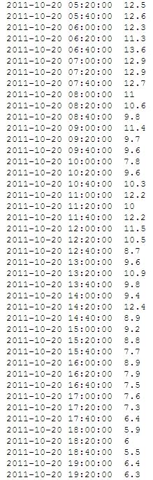
14 Sample Data 10/15 16/2011: Year, Month, Day: Hour, Minute, Second: WGR=Wind Gust in meters per second :20: :40: :00: :20: :40: :00: :20: :40: :00: :20: :40: :00: :20: :40: :00: :20: :40: :00: :20: :40: :00: :20: :40: :00: :20: :40: :00: :20: :40: :00: :20: :40: :00: :20: :40: :00: :20: :40: :00: :20: :40: :00: :20: :40: :00: :20: :40: :00: :20: :40: :00: :20: :40: :00: :20: :40: :00: :20: :40: :00: :20: :40: :00: :20: :40: :00: :20: :40: :00: :20: :40: :00: :20: :40: :00: :20: :40: :00: :20: :40: :00: :20: :40: :00: :20: :40: :00: :20: :40: :00: :20: :40: :00: :20: :40: :00: :20: :40: :00: :20: :40: :00: :20: :40:00 4.8


15 Sample Wind Gust Data: 10/17 18/ :00: :20: :40: :00: :20: :40: :00: :20: :40: :00: :20: :40: :00: :20: :40: :00: :20: :40: :00: :20: :40: :00: :20: :40: :00: :20: :40: :00: :20: :40: :00: :20: :40: :00: :20: :40: :00: :20: :40: :00: :20: :40: :00: :20: :40: :00: :20: :40: :00: :20: :40: :00: :20: :40: :00: :20: :40: :00: :20: :40: :00: :20: :40: :00: :20: :40: :00: :20: :40: :00: :20:


16 Sample Wind Gust Data: 10/19 20/2011
17 Sample Graph (wind speed at noon in red; wind speed at 14:20 in blue) Wind Gusts in October Wind Speed, meters per second Day, October 2011


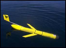
18 Track of the USF COT glider Bass; 10/12 to 11/08/2011; deployed for 28 days; traveled 38 km; max depth 39.1 m; This is the same area of the HAB event shown with the satellite data.
19
, how might you explain the obvious difference in")
20 Way Points WP2 and WP 7 are at the same location, approximately two weeks apart. Using the temperature and salinity graphs (next slide), how might you explain the obvious difference in density from WP2 and WP 7?
21

22 Air Sea Interactions are Important 100 Air Temperature, Sarastoa, FL, October 2011 Note the drop in air temperature around October 20 th Air Temperature, Fahrenheit Day, October

23 For more glider data from this mission: See Mission 54 Image courtesy of the Center for Ocean Technology, University of South Florida College of Marine Science
24 Education Resources Orbital: Ocean Remote Sensing Base for Interactive Teaching and Learning MBARI EARTH Bridge Marine Education Resources
West Florida Shelf and Tampa Bay Responses to Hurricane Irma: What Happened and Why
 West Florida Shelf and Tampa Bay Responses to Hurricane Irma: What Happened and Why R.H. Weisberg Y. Liu J. Chen College of Marine Science University of South Florida St. Petersburg, FL SECOORA Webinar
Observing System Requirements for the Harmful Algal Bloom Forecast System in the Gulf of Mexico
 Observing System Requirements for the Harmful Algal Bloom Forecast System in the Gulf of Mexico July 2007 Background The Harmful Algal Bloom (HAB) Forecast System provides nowcasts and forecasts of Karenia
Introduction: The Gulf of Mexico Alliance. The Gulf GAME project MERMAid and PHINS Results & Conclusions What s next? Examples
 AAG Las Vegas March 25, 2009 Introduction: Ocean governance and Ecosystem-Based Management The Gulf of Mexico Alliance Habitat Identification and Characterization The Gulf GAME project MERMAid and PHINS
HAB Forecaster. For info on HABs in the Pacific Northwest see:
 HAB Forecaster BACKGROUND In this activity, students can take on the role as a resource manager or scientist, tasked with deciding if razor clam harvesters should go out onto the beach to harvest razor
NOAA Operational Forecast System Gulf of Mexico, Demonstration since Sep 1999; Operational since Sep 2004:
 NOAA Operational Forecast System Gulf of Mexico, Demonstration since Sep 1999; Operational since Sep 2004: An Operational forecast of impact: 0-3 days and a prediction of likelihood of a bloom for mgmt
Overview. Gulf of Mexico Alliance Ocean and Coastal Mapping Regional Ecosystem Data Management (REDM) Q2O (QARTOD to OGC) Things to Consider
 Q2O (QARTOD to OGC) Things to Consider") 1 Overview Gulf of Mexico Alliance Ocean and Coastal Mapping Regional Ecosystem Data Management (REDM) Q2O (QARTOD to OGC) Things to Consider 2 Gulf Of Mexico Alliance Partnership of the states of Alabama,
1 Overview Gulf of Mexico Alliance Ocean and Coastal Mapping Regional Ecosystem Data Management (REDM) Q2O (QARTOD to OGC) Things to Consider 2 Gulf Of Mexico Alliance Partnership of the states of Alabama,
Forecasting inshore red tide blooms using recent past offshore conditions on the West Florida Shelf
 Forecasting inshore red tide blooms using recent past offshore conditions on the West Florida Shelf Harford 1, Bill, Rykowski 2, MB, Babcock 2 EA, Karnauskas 3, M, Sagarese 3, SR, Walter 3, JF. (1) Cooperative
Understanding oceans in change: Engineering science and technological tools for distributed real-time sensing Kristin Guldbrandsen Frøysa, CMR and
 Understanding oceans in change: Engineering science and technological tools for distributed real-time sensing Kristin Guldbrandsen Frøysa, CMR and University of Bergen Anne A Hageberg, CMR Christian Michelsen
Gulf of Mexico Harmful Algal Bloom Bulletin. Region: Southwest Florida. Conditions Report. Additional Resources
 Gulf of Mexico Harmful Algal Bloom Bulletin Thursday, August 30, 2018 NOAA National Ocean Service NOAA Satellite and Information Service NOAA National Weather Service Instructions for viewing this geospatial
Lawrence Younan Senior Applications Scientist, Turner Designs February 15, Fluorometers; Experiences with Autonomous Vehicles
 Lawrence Younan Senior Applications Scientist, Turner Designs February 15, 2017 Fluorometers; Experiences with Autonomous Vehicles Outline Fluorometers specifically designed for system-level integration
NOAA s National Ocean Service. Center for Operational Oceanographic Products and Services
 NOAA s National Ocean Service Center for Operational Oceanographic Products and Services Richard Edwing, CO-OPS Acting Director January 27, 2010 Outline CO-OPS Overview Programs Observing Systems PORTS
LESSON THREE Time, Temperature, Chlorophyll a Does sea surface temperature affect chlorophyll a concentrations?
 STUDENT PAGES LESSON THREE A partnership between California Current Ecosystem Long Term Ecological Research (CCE LTER) and Ocean Institute (OI) Beth Simmons, Education and Outreach Coordinator, CCE LTER,
It s true, these activities are all facets of marine science. But they represent a pretty small part of the picture.
 Welcome. Thanks for coming to CBNERR s Discovery Lab. I m Lisa Lawrence and I m a marine educator at VIMS. Tonight, I m going to give you just glimpse of what it s like to be a marine scientist and tell
Impacts of Atmospheric Corrections on Algal Bloom Detection Techniques
 1 Impacts of Atmospheric Corrections on Algal Bloom Detection Techniques Ruhul Amin, Alex Gilerson, Jing Zhou, Barry Gross, Fred Moshary and Sam Ahmed Optical Remote Sensing Laboratory, the City College
Egypt-NOAA Cooperation: Advancing our Environmental Science, Technology, and Education
 Egypt-NOAA Cooperation: Advancing our Environmental Science, Technology, and Education T. G. Onsager NOAA Space Weather Prediction Center and NWS International Activities Office (one-year detail) Terry.Onsager@noaa.gov
Advancing Real Time Observations and Coastal Modeling Forecasts-
 Advancing Real Time Observations and Coastal Modeling Forecasts- Moving Forward in a Changing Coastal Landscape Next Generation Navigation-Coastal Operations- Coastal and Nearshore Coastal Operational
Harmful Algal Blooms (HABs) 5 Applications
 5 Applications") Harmful Algal Blooms (HABs) 5 Applications Richard P. Stumpf NOAA, National Ocean Service HAB occurrences worldwide Image from whoi.edu/redtide HAB applications: short term Management: Monitoring and Response
Harmful Algal Blooms (HABs) 5 Applications Richard P. Stumpf NOAA, National Ocean Service HAB occurrences worldwide Image from whoi.edu/redtide HAB applications: short term Management: Monitoring and Response
Use of in-situ and remote sensors, sampling, and systems for assessing extent, fate, impact, and mitigation of oil and dispersants
 Use of in-situ and remote sensors, sampling, and systems for assessing extent, fate, impact, and mitigation of oil and dispersants Gustavo Jorge Goni (NOAA/AOML, Miami, FL) Gustavo.Goni@noaa.gov and the
Bay Drift. An activity for middle or high school students on ocean currents, marine debris, and citizen science, created by CARTHE
 Bay Drift An activity for middle or high school students on ocean currents, marine debris, and citizen science, created by CARTHE (Part of the Ocean Currents & Oil Spills STEAM Lessons by CARTHE and Piano
Marine Geomorphology as a Determinant for Essential Life Habitat III
 Marine Geomorphology as a Determinant for Essential Life Habitat III marinecoastalgis.net/aag08 10:10 Dawn Wright, Oregon 10:30 Will McClintock, California 10:50 Daniel Sampson, Massachusetts 11:10 Gary
Ruoying He. Ocean Observating and Modeling Group (OOMG) North Carolina State University
 North Carolina State University") A Coupled Marine Environmental Assessment and Prediction System for the Southeastern U.S. Coastal Ocean in Support of Effective Marine Ecosystem-Based Management, Efficient Marine Operations, and Resilient
A Coupled Marine Environmental Assessment and Prediction System for the Southeastern U.S. Coastal Ocean in Support of Effective Marine Ecosystem-Based Management, Efficient Marine Operations, and Resilient
Data Management for Algal Monitoring in the Gulf of Mexico
 Data Management for Algal Monitoring in the Gulf of Mexico Scott Cross NOAA National Oceanographic Data Center/ Coastal Data Development Center (NCDDC) Outline History Current & Future Directions Needs
New NASA Ocean Observations and Coastal Applications
 New NASA Ocean Observations and Coastal Applications Duane Armstrong Chief, Applied Science & Technology Project Office August 20, 2014 1 Outline NASA s new Earth Science Ocean Science Missions for 2014
Studying the Ocean Using Live Data
 Studying the Ocean Using Live Data Overview The Argo buoy project is a major oceanographic study that harnesses the power of automated unmanned buoys traveling the world s oceans (http://www.argo.ucsd.edu/).
Background Field program information Examples of measurements Wind validation for synthetic modeling effort
 Background Field program information Examples of measurements Wind validation for synthetic modeling effort How do complex fine-scale structure and processes in coastal waters dominated by pulsed-river
OCEANOGRAPHIC DATA MANAGEMENT
 OCEANOGRAPHIC DATA MANAGEMENT Presented to: Environmental Disaster Data Management Meeting Russ Beard Director, National Coastal Data Development Center Interim Science Coordinator, Gulf Restoration Council
Long Term Autonomous Ocean Remote Sensing Utilizing the Wave Glider
 Long Term Autonomous Ocean Remote Sensing Utilizing the Wave Glider J. Griffith, K. VanderLugt, Matt Cosad Liquid Robotics 1329 Moffett Park Drive Sunnyvale, CA 94089 Abstract Rising costs of ship time
Monitoring the coastal ocean: from local to regional
 Monitoring the coastal ocean: from local to regional Luísa Bastos University of Porto / CIIMAR RAIA partners Ocean monitoring To answer key societal and scientific challenges navigation safety, fisheries,
LESSON PLAN 15. Career and Educational Development, Science, Health and Physical Education, History, ELA, Math, Social Studies
 Title: Time and Tides Wait for No One Content Area Subjects: Career and Educational Development, Science, Health and Physical Education, History, ELA, Math, Social Studies Grade level(s): Grades 3-12+
Recommended Grade Level: 8 Earth/Environmental Science Weather vs. Climate
 Lab Activity Title: Climate Factors Past and Present Recommended Grade Level: 8 Discipline: Earth/Environmental Science Topic: Weather vs. Climate Time Requirements: 90 minutes Submitted by: Karen McCabe
Adaptive Sampling in Ocean Observation Yanwu Zhang*, James Bellingham, John Ryan, Julio Harvey, Robert McEwen, and Michael Godin
 Adaptive Sampling in Ocean Observation Yanwu Zhang*, James Bellingham, John Ryan, Julio Harvey, Robert McEwen, and Michael Godin Monterey Bay Aquarium Research Institute Outline Adaptive sampling = Adapting
4. In areas where tectonic plates collide, the seafloor has deep. 5. In areas where tectonic plates separate, the seafloor has mid- ocean
 Name Date Hour Table Chapter 14 Lesson One- General Directions: Use the word bank below to complete each statement. NOT all terms are used. abyssal plains brackish water condensation energy freshwater
A case for FLH in coastal waters: monitoring the spring bloom in British Columbia, Canada, plus MCI examples
 A case for FLH in coastal waters: monitoring the spring bloom in British Columbia, Canada, plus MCI examples Jim Gower, Stephanie King, Institute of Ocean Sciences, Fisheries and Oceans Canada, Sidney
Observation system for early warning of HAB events
 Observation system for early warning of HAB events Vera L. Trainer, NOAA Fisheries Northwest Fisheries Science Center Marine Biotoxins Program Seattle, Washington, USA Juan de Fuca eddy Regional HAB OOS
Land Surface Temperature Measurements From the Split Window Channels of the NOAA 7 Advanced Very High Resolution Radiometer John C.
 Land Surface Temperature Measurements From the Split Window Channels of the NOAA 7 Advanced Very High Resolution Radiometer John C. Price Published in the Journal of Geophysical Research, 1984 Presented
Darren Wright Maritime Services Program Manager Center for Operational Oceanographic Products and Services (CO-OPS)
") Darren Wright Maritime Services Program Manager Center for Operational Oceanographic Products and Services (CO-OPS) Center for Operational Oceanographic Products and Services (CO-OPS) National Water Level
Darren Wright Maritime Services Program Manager Center for Operational Oceanographic Products and Services (CO-OPS) Center for Operational Oceanographic Products and Services (CO-OPS) National Water Level
Optical Detection and Assessment of the Harmful Alga, Karenia brevis
 Optical Detection and Assessment of the Harmful Alga, Karenia brevis Steven E. Lohrenz Department of Marine Science The University of Southern Mississippi 1020 Balch Boulevard Stennis Space Center, MS
OSU Ocean Observing Center
 OSU Ocean Observing Center and The Ocean Observatories Initiative OSU Retirement Association March 10,19 2016 2 Early Ocean Observations OSU Retirement Association March 10,19 2016 3 No information off
National Ocean Technology Center of China Wang Xiangnan
 National Ocean Technology Center of China Wang Xiangnan 2011.10 1 National Ocean Technology Center Beijing Tianjin NOTC Established in 1965 Staff of 500 Bohai Sea 2 3 National Ocean Technology Center Administrated
HY-2A Satellite User s Guide
 National Satellite Ocean Application Service 2013-5-16 Document Change Record Revision Date Changed Pages/Paragraphs Edit Description i Contents 1 Introduction to HY-2 Satellite... 1 2 HY-2 satellite data
Preliminary Results from Coordinated Sea-Level Rise Modeling Using SLAMM, the Sea Level Affecting Marshes Model, Across the US Gulf of Mexico Coast
 Preliminary Results from Coordinated Sea-Level Rise Modeling Using SLAMM, the Sea Level Affecting Marshes Model, Across the US Gulf of Mexico Coast James W. Pahl, Ph.D., and Kristin DeMarco, State of Louisiana
A Review of the 2014 Gulf of Mexico Wave Glider Field Program
 A Review of the 2014 Gulf of Mexico Wave Glider Field Program Pat Fitzpatrick, Yee Lau, Robert Moorhead, Adam Skarke Mississippi State University Daniel Merritt, Keith Kreider, Chris Brown, Ryan Carlon,
Navigating the Hurricane Highway Understanding Hurricanes With Google Earth
 Navigating the Hurricane Highway Understanding Hurricanes With Google Earth 2008 Amato Evan, Kelda Hutson, Steve Kluge, Lindsey Kropuenke, Margaret Mooney, and Joe Turk Images and data courtesy hurricanetracking.com,
Changes in Ecosystems - Natural Events
 Changes in Ecosystems - Natural Events 8A predict and describe how different types of catastrophic events impact ecosystems such as floods, hurricanes, or tornadoes Textbook pages: 396-406 How can ecosystems
Toward Environmental Predictions MFSTEP. Executive summary
 Research Project co-funded by the European Commission Research Directorate-General 5 th Framework Programme Energy, Environment and Sustainable Development Contract No. EVK3-CT-2002-00075 Project home
Earth Wind & Fire. Game Changing Restoration Options in the Texas Chenier Plain
 Earth Wind & Fire Game Changing Restoration Options in the Texas Chenier Plain EARTH: The Chenier Plain is a 5 million acre coastal region in Southwest Louisiana and Southeast Texas providing landscape
Course Catalog Course Number Discipline/Course Instructor(s) Frequency Biological Oceanography OCB 6050 Biological Oceanography (core course) Peebles
 Frequency Biological Oceanography OCB 6050 Biological Oceanography (core course) Peebles") Course Catalog Course Number Discipline/Course Instructor(s) Frequency Biological Oceanography OCB 6050 Biological Oceanography (core course) Peebles Every Fall OCE 6934 Dynamics of Marine Ecosystems (MRA
Course Catalog Course Number Discipline/Course Instructor(s) Frequency Biological Oceanography OCB 6050 Biological Oceanography (core course) Peebles Every Fall OCE 6934 Dynamics of Marine Ecosystems (MRA
Toward a Revised RCOOS Plan for SECOORA
 Toward a Revised RCOOS Plan for SECOORA Robert Weisberg College of Marine Science University of South Florida St. Petersburg, FL SECOORA Annual Workshop May 2017 Ad hoc Committee Axiom Gap Filling Tool
NOAA S Arctic Program in 2017
 NOAA S Arctic Program in 2017 NOAA s Arctic Mission To determine how the Arctic system is changing on time scales of weeks to decades, particularly with respect to the consequences that the loss of sea
Tampa Bay Storm Surge & Wave Vulnerability, Response to Hurricane Irma and Tools for Future Use
 Tampa Bay Storm Surge & Wave Vulnerability, Response to Hurricane Irma and Tools for Future Use Robert H. Weisberg with J. Chen, Y. Liu and L. Zheng College of Marine Science University of South Florida
Newsletter of the Gulf of Mexico Coastal Ocean Observing System
 Newsletter of the Gulf of Mexico Coastal Ocean Observing System GCOOS News and Updates for 29 June 2012 Gulf of Mexico Regional News GCOOS-RA and Sanibel-Captiva Conservation Foundation co-sponsor Water
C M E M S O c e a n C o l o u r S a t e l l i t e P r o d u c t s
 Implemented by C M E M S O c e a n C o l o u r S a t e l l i t e P r o d u c t s This slideshow gives an overview of the CMEMS Ocean Colour Satellite Products Marine LEVEL1 For Beginners- Slides have been
Careful, Cyclones Can Blow You Away!
 Title: Careful, Cyclones Can Blow You Away! (Meteorology) Grade(s): 6-8 Introduction: Most people associate twisters with tornadoes, but in fact tropical twisters come from hurricanes. Hurricanes are what
Missions from MARS: Marine Autonomous and Robotic Systems - current and future science applications
 Missions from MARS: Marine Autonomous and Robotic Systems - current and future science applications Dr Russell B Wynn (MARS Chief Scientist, Head of NOC Marine Geoscience) Marine Autonomous and Robotic
Your web browser (Safari 7) is out of date. For more security, comfort and. the best experience on this site: Update your browser Ignore
 is out of date. For more security, comfort and. the best experience on this site: Update your browser Ignore") Your web browser (Safari 7) is out of date. For more security, comfort and Activitydevelop the best experience on this site: Update your browser Ignore Extracting Gas from Shale How is natural gas extracted
Your web browser (Safari 7) is out of date. For more security, comfort and Activitydevelop the best experience on this site: Update your browser Ignore Extracting Gas from Shale How is natural gas extracted
Arctic. Ocean Observing Build Out Plan. alaska ocean observing system. March 1, 2013 draft. Tom Van Pelt
 Arctic Ocean Observing Build Out Plan March 1, 2013 draft Tom Van Pelt alaska ocean observing system Tom Van Pelt Why a coastal observing system in the Arctic? The Arctic is booming with increased activity
HF radarcontribution to South Africa Blue Economy
 HF radarcontribution to South Africa Blue Economy Anton G Kjelaas1, Andres Alonso- Martirena2, Chad Whelan3 South Africa- Norway Science Week 2016 Oct 31- Nov 4 2016 1 2 3 BLUE ECONOMY Sustainable use
Evolution of NOAA s Observing System Integrated Analysis (NOSIA)
") Evolution of NOAA s Observing System Integrated Analysis (NOSIA) Presented to the 13th Symposium on Societal Applications: Policy, Research and Practice (paper 9.1) Louis Cantrell Jr., and D. Helms, R.
Evolution of NOAA s Observing System Integrated Analysis (NOSIA) Presented to the 13th Symposium on Societal Applications: Policy, Research and Practice (paper 9.1) Louis Cantrell Jr., and D. Helms, R.
Sharks and Tropical Weather
 Target Audience: Middle - High School (8-12) Sharks and Tropical Weather Resources: Research data based on Running before the Storm: blacktip sharks respond to falling barometric pressure associated with
Contribution of Norwegian partners (Aanderaa Data Instruments and NIVA) to Safeport project ( ). Final report
 to Safeport project ( ). Final report") Contribution of Norwegian partners (Aanderaa Data Instruments and NIVA) to Safeport project (2010-2012). Final report NFR-196866 Entry and Berthing Ship and Port Advising System as an Element of Port ITS.
Contribution of Norwegian partners (Aanderaa Data Instruments and NIVA) to Safeport project (2010-2012). Final report NFR-196866 Entry and Berthing Ship and Port Advising System as an Element of Port ITS.
The Physical Context for Thin Layers in the Coastal Ocean
 The Physical Context for Thin Layers in the Coastal Ocean David M. Fratantoni Physical Oceanography Department Woods Hole Oceanographic Institution Woods Hole, MA 02543 phone: (508) 289-2908 fax: (508)
Deepwater Horizon Gulf of Mexico Oil Spill NSF Rapid Response Research
 Deepwater Horizon Gulf of Mexico Oil Spill NSF Rapid Response Research Presentation to the Ocean Leadership 2011 Public Policy Forum Consortium for Ocean Leadership Dr. David Conover National Science Foundation
Observing the Ocean:
 Observing the Ocean: A changing Paradigm A vision for Operational Oceanography James Baker* - Jean-François Minster ** * Chair Goos Committee,, Président CEO Academy of Natural Sciences Philadelphie **
Your web browser (Safari 7) is out of date. For more security, comfort and. the best experience on this site: Update your browser Ignore
 is out of date. For more security, comfort and. the best experience on this site: Update your browser Ignore") Your web browser (Safari 7) is out of date. For more security, comfort and Activitydevelop the best experience on this site: Update your browser Ignore Rescuing, Relocating, and Rehabilitating Wildlife
Your web browser (Safari 7) is out of date. For more security, comfort and Activitydevelop the best experience on this site: Update your browser Ignore Rescuing, Relocating, and Rehabilitating Wildlife
Session 3 Presentation - An Overview of Recent Wave Glider Field Program
 University of New Orleans ScholarWorks@UNO Ocean Waves Workshop Ocean Waves Workshop 2017 Dec 7th, 1:15 PM - 2:00 PM Session 3 Presentation - An Overview of Recent Wave Glider Field Program Pat Fitzpatrick
Can buoys predict hurricanes? Objectives Students will be able to: track drifter buoys determine the course of the gulf stream current
 Drifters Can buoys predict hurricanes? Objectives Students will be able to: track drifter buoys determine the course of the gulf stream current Materials computers with Internet access Student Worksheet
Recent Directions in the Weisberg Lab
 Recent Directions in the Weisberg Lab by Robert H. Weisberg * Distinguished University Professor Professor of Physical Oceanography College of Marine Science, University of South Florida, St. Petersburg,
The Delaware Environmental Monitoring & Analysis Center
 The Delaware Environmental Monitoring & Analysis Center Tina Callahan Delaware Estuary Science & Environmental Summit 2013 January 27-30, 2013 What is DEMAC? Delaware Environmental Monitoring & Analysis
The Tampa Bay Catastrophic Plan Presentation to CFGIS Users Group FDOT District 5 Urban Offices - Orlando July 30, 2010
 The Tampa Bay Catastrophic Plan Presentation to CFGIS Users Group FDOT District 5 Urban Offices - Orlando July 30, 2010 Brady Smith Senior Planner Tampa Bay Regional Planning Council Introduction Recent
3. Recognize that when a science investigation is replicated, very similar results are expected.
 STANDARD 5.1 SCIENTIFIC PROCESSES ALL STUDENTS WILL DEVELOP PROBLEM-SOLVING, DECISION-MAKING AND INQUIRY SKILLS, REFLECTED BY FORMULATING USABLE QUESTIONS AND HYPOTHESES, PLANNING EXPERIMENTS, CONDUCTING
Hurricane Season 2010 & NOAA s Deepwater Response
 Hurricane Season 2010 & NOAA s Deepwater Response What s Happened? What Will 2010 Bring? Possible Shoreline Effects Darin Figurskey Meteorologist-in-Charge NOAA s NWS Raleigh, NC NOAA s National Weather
The Coastal Ocean Applications and Science Team (COAST): Science Support for a Geostationary Ocean Color Imager for Coastal Waters
: Science Support for a Geostationary Ocean Color Imager for Coastal Waters") The Coastal Ocean Applications and Science Team (COAST): Science Support for a Geostationary Ocean Color Imager for Coastal Waters PIs: Curt Davis and Mark Abbott NOAA Technical Contact: Paul Menzel, NOAA/STAR.
The Coastal Ocean Applications and Science Team (COAST): Science Support for a Geostationary Ocean Color Imager for Coastal Waters PIs: Curt Davis and Mark Abbott NOAA Technical Contact: Paul Menzel, NOAA/STAR.
EROSIONAL RATES IN THE POINT AUX CHENES BAY AREA, MISSISSIPPI: Kathleen P. Wacker G. Alan Criss INTRODUCTION
 Summary of a Paper Presented at the: Sixtieth Annual Meeting of the Mississippi Academy of Sciences in Jackson, Mississippi February 22, 1996 ===============================================================
Capturing a Holistic Understanding of a Large Marine Ecosystem The NOAA Gulf of Mexico Data Atlas
 Capturing a Holistic Understanding of a Large Marine Ecosystem The NOAA Gulf of Mexico Data Atlas NODC / National Coastal Data Development Center gulfalas.noaa.gov Need: data that contribute to long-term
Where in the World? Plotting Latitude & Longitude
 Where in the World? Plotting Latitude & Longitude Background Because our planet is a sphere, we need two types of reference lines to locate positions on the Earth and to make accurate maps. These imaginary
Hurricane Protection and Environmental Restoration
 November 16, 2010 Hurricane Protection and Environmental Restoration Presented by: Colonel (Ret.) Leonard Waterworth AGENDA How do we protect People/Environment/Economy 1900 Year Storm Hurricane Carla
Newsletter of the Gulf of Mexico Coastal Ocean Observing System
 Newsletter of the Gulf of Mexico Coastal Ocean Observing System GCOOS News and Updates for 28 June 2013 Gulf of Mexico Regional News NOAA & Partners Release 2013 Gulf Hypoxia Predictions The annual Gulf
Copernicus Today and Tomorrow GEO Week Group on Earth Observation Geneva, 16 January 2014 The Copernicus Space Infrastructure
 Copernicus Today and Tomorrow GEO Week Group on Earth Observation Geneva, 16 January 2014 The Copernicus Space Infrastructure Thomas Beer, Policy Coordinator, Copernicus Space Office, ESA-ESRIN, Frascati
Hurricane Katrina and Oil Spills: Impact on Coastal and Ocean Environments
 Archived version from NCDOCKS Institutional Repository http://libres.uncg.edu/ir/asu/ Pine, J. C. (June 2006). Hurricane Katrina and oil spills: Impact on coastal and ocean environments. Oceanography,
SPATIAL CHARACTERISTICS OF THE SURFACE CIRCULATION AND WAVE CLIMATE USING HIGH-FREQUENCY RADAR
 SPATIAL CHARACTERISTICS OF THE SURFACE CIRCULATION AND WAVE CLIMATE USING HIGH-FREQUENCY RADAR Apisit Kongprom,Siriluk Prukpitikul, Varatip Buakaew, Watchara Kesdech, and Teerawat Suwanlertcharoen Geo-Informatics
Automated ocean color product validation for the Southern California Bight
 Automated ocean color product validation for the Southern California Bight Curtiss O. Davis a, Nicholas Tufillaro a, Burt Jones b, and Robert Arnone c a College of Earth, Ocean and Atmospheric Sciences,
SAWS: Met-Ocean Data & Infrastructure in Support of Industry, Research & Public Good. South Africa-Norway Science Week, 2016
 SAWS: Met-Ocean Data & Infrastructure in Support of Industry, Research & Public Good South Africa-Norway Science Week, 2016 Marc de Vos, November 2016 South Africa: Context http://learn.mindset.co.za/sites/default/files/resourcelib/e
Report Benefits and Challenges of Geostationary Ocean Colour Remote Sensing - Science and Applications. Antonio Mannino & Maria Tzortziou
 Report Benefits and Challenges of Geostationary Ocean Colour Remote Sensing - Science and Applications Antonio Mannino & Maria Tzortziou Time & Space Scales of OC Relevant Missions GOCI I & II Geo from
Current Ph.D. College of Public Service and Community Solutions School of Public Affairs, Arizona State University, Expected Graduation-2019
 Jake R. Nelson October 2017 Arizona State University College of Public Service and Community Solutions 411 N Central Ave, Phoenix, AZ 85004. email:jakenels@gmail.com, jrnels20@asu.edu, nelsonjr@netl.doe.gov
Operational Estuarine & Coastal Forecast Systems in NOAA s. National Ocean Service
 Operational Estuarine & Coastal Forecast Systems in NOAA s. National Ocean Service Eugene Wei, Frank Aikman III and Richard Patchen NOAA S S National Ocean Service Workshop on: Data Assimilation in Support
Department of Geosciences. Geology Meteorology Oceanography
 Department of Geosciences Geology Meteorology Oceanography Geoscientists study the earth Rivers Soils Lake sediments Evidence of ancient oceans Maps Volcanoes Fence offset by San Andreas fault Water quality
Optimal Asset Distribution for Environmental Assessment and Forecasting Based on Observations, Adaptive Sampling, and Numerical Prediction
 DISTRIBUTION STATEMENT A. Approved for public release; distribution is unlimited. Optimal Asset Distribution for Environmental Assessment and Forecasting Based on Observations, Adaptive Sampling, and Numerical
Key Concept(s) The ocean is divided into zones based on physical characterisics such as sunlight, temperature, and depth.
 The ocean is divided into zones based on physical characterisics such as sunlight, temperature, and depth.") Lesson Plan Life in the Twilight Zone: Adaptaions for living at diferent depths of the ocean Summary This lesson will explore how scienist's divide the ocean into zones based on physical characterisics
Lesson Plan Life in the Twilight Zone: Adaptaions for living at diferent depths of the ocean Summary This lesson will explore how scienist's divide the ocean into zones based on physical characterisics
Global Warming: Rising Sea Level
 Global Warming: Rising Sea Level Possible explanation for why human-induced global warming is still controversial 2007 - IPCC sea level rise estimate 1. Expansion due to warming of seawater... 28 cm 2.
Arctic Observing Systems Challenges, New opportunities and Integration
 Arctic Observing Systems Challenges, New opportunities and Integration Japan Norway Arctic Science Week 03 June 2016 By Stein Sandven, NERSC Building an integrated Arctic Observing System Need to collect,
EUMETSAT s Copernicus Marine Data Stream (CMDS)
") EUMETSAT s Copernicus Marine Data Stream (CMDS) Hayley Evers-King (PML, Copernicus Ocean Training Service), Mark Higgins Copernicus Sentinel 3 marine data Sentinel 3 SRAL (Altimetry) SLSTR (SST) OLCI (Ocean
EUMETSAT s Copernicus Marine Data Stream (CMDS) Hayley Evers-King (PML, Copernicus Ocean Training Service), Mark Higgins Copernicus Sentinel 3 marine data Sentinel 3 SRAL (Altimetry) SLSTR (SST) OLCI (Ocean
How Warm Is the Ocean?
 Currents and Sea Surface Temperature By Steven Moore, Jennifer Vuturo-Brady, and Hedley Bond Guiding Question Learning Objectives How do ocean currents impact seasonal sea surface temperatures? Students
OCEAN COLOUR MONITOR ON-BOARD OCEANSAT-2
 OCEAN COLOUR MONITOR ON-BOARD OCEANSAT-2 Rangnath R Navalgund Space Applications Centre Indian Space Research Organisation Ahmedabad-380015, INDIA OCEANSAT-2 2 MISSION OCEANSAT-2 2 is a global mission
Robert Weaver, Donald Slinn 1
 1 1 Robert Weaver, Donald Slinn 1 Department of Civil and Coastal Engineering, University of Florida, Gainesville, Florida Supported by the US Office of Naval Research AGU Fall Meeting 2002 Poster OS72A-0342
PRESS RELEASE LOUISIANA UNIVERSITIES MARINE CONSORTIUM July 31, 2011
 PRESS RELEASE LOUISIANA UNIVERSITIES MARINE CONSORTIUM July 31, 2011 Scientists have returned from mapping the 2011 area of hypoxia, commonly known as the Dead Zone, along the Louisiana coast. This year
NOAA Observing System Integrated Analysis (NOSIA) Applications
 Applications") NOAA Observing System Integrated Analysis (NOSIA) Applications Aaron Pratt 1,2, PhD, David Helms 2, Louis Cantrell 2,4, PhD, Vincent Ries 4 1 Science and Technology Corporation 2 NOAA/NESDIS/OSD/TPIO 3
NOAA Observing System Integrated Analysis (NOSIA) Applications Aaron Pratt 1,2, PhD, David Helms 2, Louis Cantrell 2,4, PhD, Vincent Ries 4 1 Science and Technology Corporation 2 NOAA/NESDIS/OSD/TPIO 3
The Southern California Coastal Ocean Observing System SCCOOS. Ocean at your fingertips
 The Southern California Coastal Ocean Observing System SCCOOS Ocean at your fingertips Ivona Cetinic University of Southern California www.sccoos.org Outline Overview Ocean observing systems - general
Marine Spatial Planning (MSP): A practical approach to ecosystembased
: A practical approach to ecosystembased") Marine Spatial Planning (MSP): A practical approach to ecosystembased management Erik Olsen, Institute of Marine Research, Norway Fanny Douvere, International Oceanographic Commission Overview Why we need
Marine Spatial Planning (MSP): A practical approach to ecosystembased management Erik Olsen, Institute of Marine Research, Norway Fanny Douvere, International Oceanographic Commission Overview Why we need
The Lake Superior water monitoring and information system
 Michigan Technological University Digital Commons @ Michigan Tech Michigan Tech Research Institute Publications Michigan Tech Research Institute 1-28-2012 The Lake Superior water monitoring and information
BEST OF COSEE HANDS-ON ACTIVITIES
 BEST OF COSEE HANDS-ON ACTIVITIES Activity Title: Improving Oil Spill Response: Plotting the Currents in Prince William Sounds Learning Objectives Students find and use data from the Alaska Ocean Observing