The Southern California Coastal Ocean Observing System SCCOOS. Ocean at your fingertips
|
|
|
- Elvin Briggs
- 5 years ago
- Views:
Transcription
1 The Southern California Coastal Ocean Observing System SCCOOS Ocean at your fingertips Ivona Cetinic University of Southern California
2 Outline Overview Ocean observing systems - general History of SCCOOS SCCOOS today who how where Primary Elements of SCCOOS Our part in SCCOOS HF radars Boat operations Manual sampling Gliders Classroom applications Ideas for classroom Possible collaborations?

3 Ocean observatory systems networks that can monitor conditions in critical coastal and remote open-ocean locations provide a continuous flow of data in near-real time to scientists and marine resource managers onshore provide critical information for research on climate change, biogeochemical cycles, ecosystem assessment, and environmental hazard From Monterey Bay 2006 field experiment enhances presence in the ocean follow the changes in the ocean over longer period of time


4 Discrete vs. Continuous data household example Lot of unknown gaps in the science too! Continuous, real time data allows us to better interpret processes in the ocean

5 Development of Collaborative Observational Efforts - Southern California Historical observing systems Evolution of NPDES efforts Specialized observation efforts Integrated ocean observing system
6 Historical Ocean Observing Systems in Southern California CalCOFI (California Cooperative Fisheries Investigations) >50 years NOAA Buoys CDIP Coastal Wave Prediction NPDES Permittee Monitoring (Clean Water Act) Local Monitoring Regional Monitoring / Assessment beginning 1994
7 Evolution of NPDES Regional Monitoring Bight 94 (EMAP affiliation) Goal: State of the Bight Municipal monitoring agencies only Agency transition from independent local sampling to regionally coordinated sampling Bight 98 Beginning of academic collaboration with monitoring agencies Water Quality focus on Stormwater Runoff Bight 03 Larger role of academic involvement Collaboration of SCCOOS Components to provide complementary observational tools Remote sensing Drifters HF Radar surface current mapping
 Palos Verdes DDT Contamination 1992-93 (NOAA funded) Imperial Beach Bacterial Contamination 2000-present (State,")
8 Focused Observational Programs: Specific Problem Areas USC/SCCWRP Santa Monica Bay Stormwater (Funding: LA County, LA City, Sea Grant) Huntington Beach Bacterial Contamination (Fed l, State, County, City) Palos Verdes DDT Contamination (NOAA funded) Imperial Beach Bacterial Contamination 2000-present (State, City)

9 SCCOOS established by MOU in 2003

10 Cal Poly, SLO University of California, Santa Barbara University of Southern California University of California, Los Angeles Jet Propulsion Laboratories Southern California Coastal Water Research Project Scripps Institution of Oceanography CALIT2 Raytheon Corporation CODAR Ocean Sensors NOAA USGS ACOE ONR OCSD Los Angeles Regional Board
11 EDUCATION MONITORING OBSERVING RESEARCH Monitoring: systematic collection of mission driven environmental data to determine current conditions, trends, variation Observing: collection of real-time environmental data for a host of uses Research: scientific investigation and scholarly pursuit of knowledge Education: presentation of information in a manner that people can take action
12 .the many layers of an integrated coastal observing system water quality surface current measurements marine life resources satellite and aircraft remote sensing coastal hazards physical,bio-optical moorings educators autonomous vehicles search and rescue meteorological measurements spill response modeling security distributed databases regional marine science.?.? O in b se fr r as v i tr n g uc tu re Existing agency monitoring d n E r e us ne s d e

13 Organization structure for SCCOOS


14 Partnerships with Agencies, Private companies, NGO community.
15 Primary Elements of SCCOOS Coastal Ocean Current Mapping (HF Radar Network) Meteorological stations Automated shore stations Manual shore station Boat based programs Moorings + bouys Gliders Remote Sensing Data Assimilation Modeling Data Base Development and Management

16
17 Primary Elements of SCCOOS Coastal Ocean Current Mapping (HF Radar Network) Meteorological stations Automated shore stations Manual shore station Boat based programs Moorings + bouys Gliders Remote Sensing Data Assimilation Modeling Data Base Development and Management

18 Meteorological stations along the coast provide wind speed, wind direction, air temperature, relative humidity, barometric pressure, solar radiation, rainfall and water temperature data coastal circulation, upwelling and changes to the weather and climate

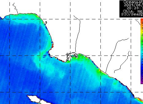
19 Remote Sensing OCM, MODIS, and GOES satellites for ocean color products chlorophyll and turbidity, sea surface temperature, and atmospheric conditions
20 Automated shore stations suite of sensors at piers along the California coast automated sensors measure temperature, salinity, chlorophyll, turbidity and water level local and regional information on mixing and upwelling, land run-off, and algal blooms.
 properties of thediego) ocean 217 181 sites in thethat Losare San Angeles Diego region and to Santa Barbara")

21 Cast data integration program snapshots of regional conditions at the time data are collected Bight Loma Water &Quality Southsample Data Bay Ocean (Central Outfall BightPermit Water Programs Quality Point boat based programs physical, chemical and biological Working (City of San Group) properties of thediego) ocean sites in thethat Losare San Angeles Diego region and to Santa Barbara region using instruments mounted the ship or are deployed Temperature, and Coliforms anddisplayed E. Coli overboard at specificsalinity, stationsdensity, Chlorophyll, Coliforms, displayed available and for available download. download. discreteand samples provide finefor scale data ongoing series of cruises (CalCOFI) are invaluable for analysis of seasonal, interannual or long term changes in the ocean ecosystem. Captain

22 Manual shore station - SCCOOS Water Quality Project involves 6 Health Agencies Encompasses 525 shoreline stations Regular monthly and/or weekly updates Ingests AB411 state mandated shoreline monitoring

23 Moorings + Buoys several packages of automated sensors which are spaced throughout the water column Measure water temperature, salinity, turbidity, chlorophyll, nutrients, speed and direction of currents data is used in model forecasts, as well as in analysis of long term ocean trends.
 Transmit antenna ocean surface - receive")
24 Coastal Ocean Current Mapping (HF Radar Network) Specific length radio waves reflect off of the ocean surface infer the speed and direction of ocean surface currents (to 1 meter s depth) Transmit antenna ocean surface - receive antenna

25 Coastal Ocean Current Mapping (HF Radar Network) surface waves - half of the radar wavelength to be reflected back to the radar system Doppler shift twd or away from the radar For true direction and velocity of surface waves, at least 2 radars needed
26 Tracking plumes in time HF Radar and Modeling

27 Tracking plumes in time HF Radar and Satellite Remote Sensing
 Movement pre-setup coordinates Low speed low energy cost long deployment Seaglider (UW), Spray (Scripps) & Slocum")
28 Gliders Vertical movement fish bladder concept Horizontal movement - wings Control - Rudder or changing the center of the mass Two way communication (real time) Movement pre-setup coordinates Low speed low energy cost long deployment Seaglider (UW), Spray (Scripps) & Slocum (Webb)
 Phycoerythrin / Rhodamine WT Temperature, Salinity and Depth")
29 Gliders Measurements: Scattering Particle abundance and size Fluorescence channels Chlorophyll (~ primary production, algae) Colored Dissolved Organic Matter (important for runoff and effluent plumes) Phycoerythrin / Rhodamine WT Temperature, Salinity and Depth (CTD)
30 SCCOOS HAB COASTAL SURVEILLANCE PROGRAM Automated Pier Stations T, S, Chl. Fluor. Group time series (weekly) Nutrients, Chlorophyll, HAB Species, DA analysis Glider monitoring San Pedro Bay Remote sensing imager of ocean color


31 HAB s monitoring Caron lab, USC
32 Huntington Beach Study Sept-Oct 2006 (HB06) Collaborative, interdisciplinary, multiscale effort to: Monitor Predict Understand Provide real-time availability of nearshore coastal observations relevant to managerial decision making
33 Components Surf Zone (UCSD) Moorings (USGS, OCSD, UCSD) Drifters (UCSB) AUVs REMUS (CPSLO) AUVs Gliders (CPSLO, UCSD) HF Radar (USC, UCSD) Numerical Models (UCLA, JPL) Meteorology (JPL) Dye Studies (UCSD, USC, OCSD) Microbiology (OCSD) Biology (USC, UCSD, CPSLO)


34 Transition Zone Moorings


35 Surf Zone Array Surf Zone Tripods Surf Zone Drifters Surf zone mapping, dye studies, drifters Surf Zone T, S, currents
36 So what are the advantages of using real-time data in the classroom? National Assessment of Educational Progress (NAEP) Science findings of 2000, which revealed a statistically significant increase in scores of those students who downloaded and analyzed data, there also exists compelling evidence that this approach to science instruction improves standardized test scores (National Center for Education Statistics, 2001). Furthermore, in a review of studies on problem solving, it was concluded good problem solvers work harder than poor problem solvers. Most studies of thinking find that problem solvers need to be conscious of their own reasoning processes by talking or writing down their thoughts (Lockhead 1981). Taken from..
37 Classroom ocean observatory station Currents HF radar, meteorological stations, winds Coastal pollution HF radar, models, rainfall, satellite imagery Food webs, fishy!! Satellite imagery, automatic stations
38 Possible collaboration student conducted glider deployment Define a problem: Use the available data on SCCOOS website to find a process of interest HAB bloom, upwelling, sewage spill, river plume tracking or just explore the ocean Make a hypothesis we come to your class discuss the problem with you Plan the glider deployment You come over to our lab, we show you all our toys and all together plan the glider deployment where, when, how long, what data is important
39 Glider deployment deploy the glider stream the data directly to your computer /class (receive text message from the glider!!!!) Students can follow the incoming data real time, write a blog about glider movement and observations After glider deployment Students analyze the data (with our help) Use other real-time data available through SCCOOS website Write a final report
40 Thank you
Observation system for early warning of HAB events
 Observation system for early warning of HAB events Vera L. Trainer, NOAA Fisheries Northwest Fisheries Science Center Marine Biotoxins Program Seattle, Washington, USA Juan de Fuca eddy Regional HAB OOS
LESSON THREE Time, Temperature, Chlorophyll a Does sea surface temperature affect chlorophyll a concentrations?
 STUDENT PAGES LESSON THREE A partnership between California Current Ecosystem Long Term Ecological Research (CCE LTER) and Ocean Institute (OI) Beth Simmons, Education and Outreach Coordinator, CCE LTER,
DATA MANAGEMENT SUMMARY DETAILS. Bathymetry maps. HAB & HAB-related data. Automated & Manual Shore Stations
 DATA MANAGEMENT SUMMARY DETAILS SCCOOS continues to integrate a broad suite of observations including: surface currents, satellite imagery, wave conditions and forecasts, meteorological conditions and
South Bay Coastal Ocean Observing System California Clean Beaches Initiative
 South Bay Coastal Ocean Observing System California Clean Beaches Initiative Quarterly Report December 2003 to City of Imperial Beach Eric Terrill 1 1 Scripps Institution of Oceanography, University of
South Bay Coastal Ocean Observing System California Clean Beaches Initiative
 South Bay Coastal Ocean Observing System California Clean Beaches Initiative Third Quarterly Report April, 2003 to City of Imperial Beach Eric Terrill 1 1 Scripps Institution of Oceanography, University
HAB Forecaster. For info on HABs in the Pacific Northwest see:
 HAB Forecaster BACKGROUND In this activity, students can take on the role as a resource manager or scientist, tasked with deciding if razor clam harvesters should go out onto the beach to harvest razor
Arctic. Ocean Observing Build Out Plan. alaska ocean observing system. March 1, 2013 draft. Tom Van Pelt
 Arctic Ocean Observing Build Out Plan March 1, 2013 draft Tom Van Pelt alaska ocean observing system Tom Van Pelt Why a coastal observing system in the Arctic? The Arctic is booming with increased activity
Observing System Requirements for the Harmful Algal Bloom Forecast System in the Gulf of Mexico
 Observing System Requirements for the Harmful Algal Bloom Forecast System in the Gulf of Mexico July 2007 Background The Harmful Algal Bloom (HAB) Forecast System provides nowcasts and forecasts of Karenia
Grant Number: NA11NOS
 U.S. Integrated Ocean Observing System (IOOS) Implementation Southern California Coastal Ocean Observing System (SCCOOS) FY11-16 National Oceanographic Partnership Program Final Report: 1 June 2011 to
South Bay Coastal Ocean Observing System California Clean Beaches Initiative
 South Bay Coastal Ocean Observing System California Clean Beaches Initiative Second Quarterly Report January, 2003 to City of Imperial Beach Eric Terrill 1 1 Scripps Institution of Oceanography, University
Lawrence Younan Senior Applications Scientist, Turner Designs February 15, Fluorometers; Experiences with Autonomous Vehicles
 Lawrence Younan Senior Applications Scientist, Turner Designs February 15, 2017 Fluorometers; Experiences with Autonomous Vehicles Outline Fluorometers specifically designed for system-level integration
Yi Chao Jet Propulsion Laboratory California Institute of Technology & Joint Institute for Regional Earth System Science and Engineering (JIFRESSE)
") Strategy to Develop a 3D Ocean Circulation Forecasting System for Cook Inlet Yi Chao Jet Propulsion Laboratory California Institute of Technology & Joint Institute for Regional Earth System Science and
Strategy to Develop a 3D Ocean Circulation Forecasting System for Cook Inlet Yi Chao Jet Propulsion Laboratory California Institute of Technology & Joint Institute for Regional Earth System Science and
Name Period Part I: INVESTIGATING OCEAN CURRENTS: PLOTTING BUOY DATA
 Name Period Part I: INVESTIGATING OCEAN CURRENTS: PLOTTING BUOY DATA INTRODUCTION: Ocean currents are like huge rivers in the sea. They carry drifting organisms, vital dissolved chemical nutrients and
Automated ocean color product validation for the Southern California Bight
 Automated ocean color product validation for the Southern California Bight Curtiss O. Davis a, Nicholas Tufillaro a, Burt Jones b, and Robert Arnone c a College of Earth, Ocean and Atmospheric Sciences,
Novel Acoustic Techniques for Assessing Fish Schooling in the Context of an Operational Ocean Observatory
 Novel Acoustic Techniques for Assessing Fish Schooling in the Context of an Operational Ocean Observatory Christopher Jones Applied Physics Laboratory, University of Washington 1013 NE 40 th Street Seattle,
Assimilation Impact of Physical Data on the California Coastal Ocean Circulation and Biogeochemistry
 Assimilation Impact of Physical Data on the California Coastal Ocean Circulation and Biogeochemistry Yi Chao, Remote Sensing Solutions (RSS)/UCLA; John D. Farrara, RSS; Fei Chai, University of Maine; Hongchun
SAWS: Met-Ocean Data & Infrastructure in Support of Industry, Research & Public Good. South Africa-Norway Science Week, 2016
 SAWS: Met-Ocean Data & Infrastructure in Support of Industry, Research & Public Good South Africa-Norway Science Week, 2016 Marc de Vos, November 2016 South Africa: Context http://learn.mindset.co.za/sites/default/files/resourcelib/e
12/2/15. Providing observa.ons, data and informa.on products to meet agency and stakeholder needs
 12/2/15 Providing observa.ons, data and informa.on products to meet agency and stakeholder needs 1 Part of the Integrated Ocean Observing System (IOOS) Governed through a Memorandum of Agreement Fiscal
Ocean Observatories Initiative. Oscar Schofield Rutgers University. Ocean Leadership October 2010
 Ocean Observatories Initiative Oscar Schofield Rutgers University Ocean Leadership October 2010 What is OOI? THE VISION To launch an era of scientific discovery across and within the ocean basins, utilizing
The Delaware Environmental Monitoring & Analysis Center
 The Delaware Environmental Monitoring & Analysis Center Tina Callahan Delaware Estuary Science & Environmental Summit 2013 January 27-30, 2013 What is DEMAC? Delaware Environmental Monitoring & Analysis
NOAA S Arctic Program in 2017
 NOAA S Arctic Program in 2017 NOAA s Arctic Mission To determine how the Arctic system is changing on time scales of weeks to decades, particularly with respect to the consequences that the loss of sea
Data Management for Algal Monitoring in the Gulf of Mexico
 Data Management for Algal Monitoring in the Gulf of Mexico Scott Cross NOAA National Oceanographic Data Center/ Coastal Data Development Center (NCDDC) Outline History Current & Future Directions Needs
Introduction to Ocean Numerical Modeling #0 General Introduction. Global model SSH regional model SST
 Introduction to Ocean Numerical Modeling #0 General Introduction Global model SSH regional model SST Gildas Cambon, IRD/LOPS, France gildas.cambon@ird.fr Global model SSH WEEK 1 regional model SST Day
HFR Surface Currents Observing System in Lower Chesapeake Bay and Virginia Coast
 HFR Surface Currents Observing System in Lower Chesapeake Bay and Virginia Coast Larry P. Atkinson, Teresa Garner, and Jose Blanco Center for Coastal Physical Oceanography Old Dominion University Norfolk,
The Southern California Coastal Current Observing System
 The Southern California Coastal Current Observing System A proposal submitted to the California Coastal Conservancy by the Southern California Coastal Ocean Observing System (SCCOOS) PROJECT SUMMARY The
West Florida Shelf and Tampa Bay Responses to Hurricane Irma: What Happened and Why
 West Florida Shelf and Tampa Bay Responses to Hurricane Irma: What Happened and Why R.H. Weisberg Y. Liu J. Chen College of Marine Science University of South Florida St. Petersburg, FL SECOORA Webinar
Harmful Algal Bloom Detectives in the Gulf of Mexico Satellites, Gliders and Buoys, Oh My!
 Harmful Algal Bloom Detectives in the Gulf of Mexico Satellites, Gliders and Buoys, Oh My! By Chris Simoniello and Ruth Mullins* With information from: *The Gulf of Mexico Coastal Ocean Observing System
Ocean Imaging. Satellite and Aerial Coastal Water Quality Monitoring in The San Diego / Tijuana Region. Monthly Report for April & May 2003
 Ocean Imaging Satellite and Aerial Coastal Water Quality Monitoring in The San Diego / Tijuana Region Monthly Report for April & May 2003 This draft to become final in sixty days. All data and imagery
The Physical Context for Thin Layers in the Coastal Ocean
 The Physical Context for Thin Layers in the Coastal Ocean David M. Fratantoni Physical Oceanography Department Woods Hole Oceanographic Institution Woods Hole, MA 02543 phone: (508) 289-2908 fax: (508)
GNOME Oil Spill Modeling Lab
 GNOME Oil Spill Modeling Lab Name: Goal: After simulating an actual oil spill event, you will understand how oceanographers help to protect marine resources from pollution such as oil spills. You will
MERSEA Marine Environment and Security for the European Area
 MERSEA Marine Environment and Security for the European Area Development of a European system for operational monitoring and forecasting of the ocean physics, biogeochemistry, and ecosystems, on global
Molly McCammon Alaska Ocean Observing System October 15, 2012
 Molly McCammon Alaska Ocean Observing System October 15, 2012 Marine Operations Safe a& efficient shipping & recreational boating, search & rescue, spill response & offshore energy development Weather
Understanding oceans in change: Engineering science and technological tools for distributed real-time sensing Kristin Guldbrandsen Frøysa, CMR and
 Understanding oceans in change: Engineering science and technological tools for distributed real-time sensing Kristin Guldbrandsen Frøysa, CMR and University of Bergen Anne A Hageberg, CMR Christian Michelsen
The Use of Lagrangian Drifters to Measure Biogeochemical Processes and to Analyze Satellite Data Sets
 The Use of Lagrangian Drifters to Measure Biogeochemical Processes and to Analyze Satellite Data Sets John R. Moisan Laboratory for Hydrospheric Processes NASA Goddard Space Flight Center Pearn P. Niiler
OSU Ocean Observing Center
 OSU Ocean Observing Center and The Ocean Observatories Initiative OSU Retirement Association March 10,19 2016 2 Early Ocean Observations OSU Retirement Association March 10,19 2016 3 No information off
sentinel-3 A BIGGER PICTURE FOR COPERNICUS
 sentinel-3 A BIGGER PICTURE FOR COPERNICUS SATELLITES TO SERVE By providing a set of key information services for a wide range of practical applications, Europe s Copernicus programme has been put in place
Novel Acoustic Techniques for Assessing Fish Schooling in the Context of an Operational Ocean Observatory
 Novel Acoustic Techniques for Assessing Fish Schooling in the Context of an Operational Ocean Observatory Kelly J. Benoit-Bird College of Oceanic and Atmospheric Sciences, Oregon State University 104 COAS
NOAA s National Ocean Service. Center for Operational Oceanographic Products and Services
 NOAA s National Ocean Service Center for Operational Oceanographic Products and Services Richard Edwing, CO-OPS Acting Director January 27, 2010 Outline CO-OPS Overview Programs Observing Systems PORTS
Monitoring the coastal ocean: from local to regional
 Monitoring the coastal ocean: from local to regional Luísa Bastos University of Porto / CIIMAR RAIA partners Ocean monitoring To answer key societal and scientific challenges navigation safety, fisheries,
Ocean Currents Student Activity Book
 Ocean Currents Student Activity Book I. Introduction Ocean currents influence the weather in coastal areas. They also influence sailing vessels. Though they visibly affect many people's lives, they are
SDG&E Meteorology. EDO Major Projects. Electric Distribution Operations
 Electric Distribution Operations SDG&E Meteorology EDO Major Projects 2013 San Diego Gas & Electric Company. All copyright and trademark rights reserved. OCTOBER 2007 WILDFIRES In 2007, wildfires burned
The Field Research Facility, Duck, NC Warming Ocean Observations and Forecast of Effects
 The Field Research Facility, Duck, NC Warming Ocean Observations and Forecast of Effects A potential consequence of a warming ocean is more frequent and more intense wind events (Hurricanes & Typhoons)
Mixing and Transport in the Surfzone
 Mixing and Transport in the Surfzone Robert T. Guza Scripps Institution of Oceanography La Jolla, CA 92093-0209 phone: (858) 534-0585 fax: (858) 534-0300 email: rguza@ucsd.edu Grant number: N00014-7-1-0377
NOAA/OAR Observing Systems
 NOAA/OAR Observing Systems Dr. Christopher L. Sabine Director NOAA s Pacific Marine Environmental Laboratory Workshop on Hydroclimate Monitoring Systems and Measurement Needs June, 2014 Global Ocean Observing
It s true, these activities are all facets of marine science. But they represent a pretty small part of the picture.
 Welcome. Thanks for coming to CBNERR s Discovery Lab. I m Lisa Lawrence and I m a marine educator at VIMS. Tonight, I m going to give you just glimpse of what it s like to be a marine scientist and tell
Multivariate time-series forecasting of the NE Arabian Sea Oil Sardine fishery using satellite covariates
 Multivariate time-series forecasting of the NE Arabian Sea Oil Sardine fishery using satellite covariates Eli Holmes 1, Nimit Kumar 2, Sourav Maity 2, B.R Smitha 3, Sherine Cubelio 3, Cara Wilson 4, Narayanane
San Luis Obispo, CA Tampa, FL Rutgers University, 71 Dudley Road, New Brunswick, NJ ABSTRACT
 1 ADAPTIVE SAMPLING IN THE COASTAL OCEAN AT THE LONG ECOSYSTEM OBSERVATORY M. A. Moline 1, W. P. Bissett 2, S. Glenn 3, D. Haidvogel 3 and O. Schofield 3 1 Biological Sciences Department, California Polytechnic
Sustained observations of mesoscale and submesoscale surface circulation
 Sustained observations of mesoscale and submesoscale surface circulation off the U.S. West Coast Sung Yong Kim 1,*, Eric Terrill 1, Bruce Cornuelle 1, Burt Jones 2, Libe Washburn 3, Mark Moline 4, Jeffrey
The Coastal Field Data Collection Program (CFDC) Waves & Coastal Observations for the Corps and the Nation
 Waves & Coastal Observations for the Corps and the Nation") The Coastal Field Data Collection Program (CFDC) Waves & Coastal Observations for the Corps and the Nation Bill Birkemeier Program Manager William.Birkemeier@usace.army.mil 10 August 2010 US Army Corps
The Coastal Field Data Collection Program (CFDC) Waves & Coastal Observations for the Corps and the Nation Bill Birkemeier Program Manager William.Birkemeier@usace.army.mil 10 August 2010 US Army Corps
Alaska Ocean Observing System 101 Anchorage, Alaska
 Alaska Ocean Observing System 101 Anchorage, Alaska Molly McCammon, Director Alaska Ocean Observing System (AOOS) A Regional Observing System within the Integrated Ocean Observing System www.aoos.org IOOS
Egypt-NOAA Cooperation: Advancing our Environmental Science, Technology, and Education
 Egypt-NOAA Cooperation: Advancing our Environmental Science, Technology, and Education T. G. Onsager NOAA Space Weather Prediction Center and NWS International Activities Office (one-year detail) Terry.Onsager@noaa.gov
BEST OF COSEE HANDS-ON ACTIVITIES
 BEST OF COSEE HANDS-ON ACTIVITIES Activity Title: Improving Oil Spill Response: Plotting the Currents in Prince William Sounds Learning Objectives Students find and use data from the Alaska Ocean Observing
AOSN Monterey Bay Experiment: Creating Sustainable Ocean Observation/Prediction Systems
 AOSN Monterey Bay Experiment: Creating Sustainable Ocean Observation/Prediction Systems AOSN II Objectives: To design and build an adaptive coupled observation/modeling system. The system should be sustainable
Identifying Drifter Deployment Values
 Identifying Drifter Deployment Values Presented by: Shaun Dolk Produced in Collaboration with: Dr. Rick Lumpkin NOAA/AOML/GDP Miami, Florida DBCP-29 - September 23-27, 2013 Paris, France Objectives & Direction
State of the CA HFR Network
 ~12 years old (Statewide Network) ~15 years (Scripps, BML) >20 years (Monterey Bay & Santa Barbara) Funding Sources CA Prop 40 (2005) NOAA IOOS (Ongoing O&M) Freq (MHz) Count 5 13 13 27 25 15 40 5 Total
Detecting the Red Edge of absorption in Puget Sound from Satellite measured water-leaving radiance
 Detecting the Red Edge of absorption in Puget Sound from Satellite measured water-leaving radiance Rachel Halfhill University of Washington School of Oceanography The Pacific Northwest Center for Human
Can buoys predict hurricanes? Objectives Students will be able to: track drifter buoys determine the course of the gulf stream current
 Drifters Can buoys predict hurricanes? Objectives Students will be able to: track drifter buoys determine the course of the gulf stream current Materials computers with Internet access Student Worksheet
Serving Marine-Related Users in the Mid-Atlantic through Ocean Observing and Forecasting
 MIDDLE ATLANTIC REGIONAL ASSOCIATION COASTAL OCEAN OBSERVING SYSTEM DC MD 1000 km Cape to Cape PA DE NJ CT RI MA Cape Cod NY 10 States and D.C 111 Congressional Districts Serving Marine-Related Users in
Pioneer Array. MAB continental shelf and slope. Context: Array design:
 Pioneer Array MAB continental shelf and slope Context: Fresh water to the north drives along-shelf flow Persistent front at ~150 m isobath Complex slope sea influenced by Gulf Stream eddies and meanders
Coastal Ocean Modeling Core Proposal
 Coastal Ocean Modeling Core Proposal PROJECT SUMMARY The Coastal Ocean Modeling Core will provide coastal ocean model predictions to the Center s three R01 studies in the San Diego South Bay region. The
Regional Forecasting of California HABs
 Regional Forecasting of California HABs Chlorophyll Domoic Acid Clarissa Anderson UC Santa Cruz West Coast Regional HAB Summit February 12, 2009 Trainer et al 2000, Hickey and Banas 2003, in Kudela 2005
Eddies in the Southern California Bight
 HOME INTRODUCTION BIOLOGY POLLUTION CREDITS/LINKS Circulation in the Southern California Bight Scroll down this page to learn about current circulation in the Southern California Bight, or jump directly
NRL Modeling in Support of ASAP MURI 2006 Experiment in the Monterey Bay
 NRL Modeling in Support of ASAP MURI 2006 Experiment in the Monterey Bay Igor Shulman Naval Research Laboratory Stennis Space Center, MS 39529 phone: (228) 688-5646 fax: (228) 688-7072; e-mail: igor.shulman@nrlssc.navy.mil
Introduction: The Gulf of Mexico Alliance. The Gulf GAME project MERMAid and PHINS Results & Conclusions What s next? Examples
 AAG Las Vegas March 25, 2009 Introduction: Ocean governance and Ecosystem-Based Management The Gulf of Mexico Alliance Habitat Identification and Characterization The Gulf GAME project MERMAid and PHINS
Analysis of Physical Oceanographic Data from Bonne Bay, September 2002 September 2004
 Physics and Physical Oceanography Data Report -1 Analysis of Physical Oceanographic Data from Bonne Bay, September September Clark Richards and Brad deyoung Nov. 9 Department of Physics and Physical Oceanography
Casco Bay Estuary Partnership (CBEP) USM Muskie School 34 Bedford St 228B. Portland, ME
 USM Muskie School 34 Bedford St 228B. Portland, ME") Casco Bay Estuary Partnership (CBEP) USM Muskie School 34 Bedford St 228B Wishcamper Center Portland, ME 04104 9300 Malcolm L. Spaulding Applied Science Associates 55 Village Square Drive South Kingstown,
Casco Bay Estuary Partnership (CBEP) USM Muskie School 34 Bedford St 228B Wishcamper Center Portland, ME 04104 9300 Malcolm L. Spaulding Applied Science Associates 55 Village Square Drive South Kingstown,
MARINE WEATHER HINDCAST REPORT
 MARINE WEATHER HINDCAST REPORT PREPARED FOR US SAILING INVESTIGATIVE PANEL VESSEL : Aegean INCIDENT LOCATION : APPROX 32.45N 117.30W INCIDENT TIME : APPROX 1:30AM Apr. 28 2012 PREPARED BY SAM WILSON M.S.
Ocean sensors, the information explosion and biological oceanography
 Supported by NSERC, ONR, NOPP, CFCAS Ocean sensors, the information explosion and biological oceanography John J. Cullen Dalhousie University University of Hawaiʼi June 28, 2008 20th century oceanography:
An Integrated Network of In situ and Remote Sensors to Characterize the Somali Current
 DISTRIBUTION STATEMENT A. Approved for public release; distribution is unlimited. An Integrated Network of In situ and Remote Sensors to Characterize the Somali Current Eric J. Terrill, Ph.D. Director,
Toward Environmental Predictions MFSTEP. Executive summary
 Research Project co-funded by the European Commission Research Directorate-General 5 th Framework Programme Energy, Environment and Sustainable Development Contract No. EVK3-CT-2002-00075 Project home
Background Field program information Examples of measurements Wind validation for synthetic modeling effort
 Background Field program information Examples of measurements Wind validation for synthetic modeling effort How do complex fine-scale structure and processes in coastal waters dominated by pulsed-river
Telepresence In The Ocean
 The Ocean Observatories Initiative: Establishing A Sustained And Adaptive Telepresence In The Ocean Shelby Walker (1) (1) National Oceanic and Atmospheric Administration, Office of Oceanic and Atmospheric
MOSAiC Science Implementation The Multidisciplinary drifting Observatory for the Study of Arctic Climate
 MOSAiC Science Implementation The Multidisciplinary drifting Observatory for the Study of Arctic Climate MOSAiC Coordination Team M. Shupe. 13 March 2016 MOSAiC Plan Drifting, interdisciplinary process
Authors of abstract. Pat Fitzpatrick Jessie Kastler Frank Hernandez Carla Culpepper Candace Bright. But whole CONCORDE team contributed to results
 Authors of abstract Pat Fitzpatrick Jessie Kastler Frank Hernandez Carla Culpepper Candace Bright MSU USM USM USM USM But whole CONCORDE team contributed to results Outline of talk Field program information
Missions from MARS: Marine Autonomous and Robotic Systems - current and future science applications
 Missions from MARS: Marine Autonomous and Robotic Systems - current and future science applications Dr Russell B Wynn (MARS Chief Scientist, Head of NOC Marine Geoscience) Marine Autonomous and Robotic
Long Term Autonomous Ocean Remote Sensing Utilizing the Wave Glider
 Long Term Autonomous Ocean Remote Sensing Utilizing the Wave Glider J. Griffith, K. VanderLugt, Matt Cosad Liquid Robotics 1329 Moffett Park Drive Sunnyvale, CA 94089 Abstract Rising costs of ship time
WIND EFFECTS ON CHEMICAL SPILL IN ST ANDREW BAY SYSTEM
 WIND EFFECTS ON CHEMICAL SPILL IN ST ANDREW BAY SYSTEM PETER C. CHU, PATRICE PAULY Naval Postgraduate School, Monterey, CA93943 STEVEN D. HAEGER Naval Oceanographic Office, Stennis Space Center MATHEW
How Warm Is the Ocean?
 Currents and Sea Surface Temperature By Steven Moore, Jennifer Vuturo-Brady, and Hedley Bond Guiding Question Learning Objectives How do ocean currents impact seasonal sea surface temperatures? Students
Coastal Ocean Circulation Experiment off Senegal (COCES)
") DISTRIBUTION STATEMENT A. Approved for public release; distribution is unlimited. Coastal Ocean Circulation Experiment off Senegal (COCES) Pierre-Marie Poulain Istituto Nazionale di Oceanografia e di Geofisica
DISTRIBUTION STATEMENT A. Approved for public release; distribution is unlimited. Coastal Ocean Circulation Experiment off Senegal (COCES) Pierre-Marie Poulain Istituto Nazionale di Oceanografia e di Geofisica
Darren Wright Maritime Services Program Manager Center for Operational Oceanographic Products and Services (CO-OPS)
") Darren Wright Maritime Services Program Manager Center for Operational Oceanographic Products and Services (CO-OPS) Center for Operational Oceanographic Products and Services (CO-OPS) National Water Level
Darren Wright Maritime Services Program Manager Center for Operational Oceanographic Products and Services (CO-OPS) Center for Operational Oceanographic Products and Services (CO-OPS) National Water Level
Talk Overview. Concepts. Climatology. Monitoring. Applications
 Atmospheric Rivers Talk Overview Concepts Climatology Monitoring Applications Satellite View Where is the storm? Where is the impact? Atmospheric Rivers Plume or fire hose of tropical moisture Heavy precipitation
Salinity Processes in the Upper. Ocean Regional Study (SPURS) Ray Schmitt, WHOI
 Ray Schmitt, WHOI") Salinity Processes in the Upper Outgrowth of: Ocean Regional Study (SPURS) Ray Schmitt, WHOI CLIVAR Salinity Working Group (May 06 meeting and 07 report) Salinity issue of Oceanography (Mar. 08) NASA Workshop
Salinity Processes in the Upper Outgrowth of: Ocean Regional Study (SPURS) Ray Schmitt, WHOI CLIVAR Salinity Working Group (May 06 meeting and 07 report) Salinity issue of Oceanography (Mar. 08) NASA Workshop
TOSCA RESULTS OVERVIEW
 TOSCA RESULTS OVERVIEW Almost 3 years after the project started, TOSCA has proved capable of improving oil spill tracking systems. TOSCA has brought updated knowledge on surface currents and noticeable
Who cares about S2S research to improve forecasts?
 Who cares about S2S research to improve forecasts? Ali Stevens, Annarita Mariotti, Dan Barrie, Emily Read Climate Program Office Contact: alison.stevens@noaa.gov 16th Annual CPASW May 22-24, 2018 **Any
APPENDIX E WIND DATA. A Final Report Submitted to The Coastal Response Research Center
 Evaluation of Field-Collected Drifter and In Situ Fluorescence Data Measuring Subsurface Dye Plume Advection/Dispersion and Comparisons to High-Frequency Radar-Observation System Data for Dispersed Oil
Numerical Modelling and Data Assimilation applied to the South Atlantic Ocean
 Numerical Modelling and Data Assimilation applied to the South Atlantic Ocean Luiz Paulo Assad / Luiz Landau Universidade Federal do Rio de Janeiro COPPE Laboratório de Métodos Computacionais em Engenharia
Variability of the Surface Circulation and temperature in the Adriatic Sea
 Variability of the Surface Circulation and temperature in the Adriatic Sea Pierre-Marie Poulain Naval Postgraduate School, Code OC/Pn Monterey, CA 93943 phone: (831) 656-3318 fax: (831) 656-2712 email:
ESP Process Flow. 2/27/2012 Environmental Studies Program 1
 ESP Process Flow 2/27/2012 Environmental Studies Program 1 Studies Management Process Timeline Oct Nov Dec Jan Feb Mar Apr May Jun Jul Aug SDP Guidance Stakeholder Input Due SDP Preparation Draft SDPs
The known requirements for Arctic climate services
 The known requirements for Arctic climate services based on findings described in STT White paper 8/2015 Johanna Ekman / EC PHORS STT Regional drivers The Arctic region is home to almost four million people
Liana Talaue McManus. Division of Marine Affairs and Policy Rosenstiel School of Marine & Atmospheric Science University of Miami
 Liana Talaue McManus Division of Marine Affairs and Policy Rosenstiel School of Marine & Atmospheric Science University of Miami Outline 1. Coasts as vulnerable & resilient social ecological systems 2.
New NASA Ocean Observations and Coastal Applications
 New NASA Ocean Observations and Coastal Applications Duane Armstrong Chief, Applied Science & Technology Project Office August 20, 2014 1 Outline NASA s new Earth Science Ocean Science Missions for 2014
Biogeographic Approach to Coastal Assessments & Spatial Planning
 NOAA s Biogeographic Approach to Coastal Assessments & Spatial Planning Mark E. Monaco Mark.Monaco@noaa.gov Center for Coastal Monitoring and Assessment http://ccma.nos.noaa.gov/about/biogeography Biogeography
Office of Naval Research Arctic Observing Activities
 Office of Naval Research Arctic Observing Activities Jim Thomson Applied Physics Laboratory, University of Washington jthomson@apl.washington.edu Scott L. Harper, Program Officer, Arctic and Global Prediction
FOURTH INTERNATIONAL PORT METEOROLOGICAL OFFICERS WORKSHOP AND SUPPORT TO GLOBAL OCEAN OBSERVATIONS USING SHIP LOGISTICS
 FOURTH INTERNATIONAL PORT METEOROLOGICAL OFFICERS WORKSHOP AND SUPPORT TO GLOBAL OCEAN OBSERVATIONS USING SHIP LOGISTICS PMO-IV 8-10 DEC 2010, ORLANDO, FLORIDA, USA 1 This presentation is generally for
Satellite-based Red-Tide Detection/Monitoring
 Satellite-based Detection/Monitoring Contents 1. Introduction - and Its Monitoring System 2. Detection Using Ocean Color Remote Sensing 3. Satellite-Based Monitoring in the Asian Coastal Seas Hiroshi KAWAMURA
SPATIAL CHARACTERISTICS OF THE SURFACE CIRCULATION AND WAVE CLIMATE USING HIGH-FREQUENCY RADAR
 SPATIAL CHARACTERISTICS OF THE SURFACE CIRCULATION AND WAVE CLIMATE USING HIGH-FREQUENCY RADAR Apisit Kongprom,Siriluk Prukpitikul, Varatip Buakaew, Watchara Kesdech, and Teerawat Suwanlertcharoen Geo-Informatics
Environmental Data In Support of Search & Rescue Operations in the Central Mediterranean Sea
 Environmental Data In Support of Search & Rescue Operations in the Central Mediterranean Sea Dr. Eric Comerma (RPS ASA) eric.comerma@rpsgroup.com Cathleen Turner (RPS ASA) Prof. Aldo Drago (Univ. of Malta)
HY-2A Satellite User s Guide
 National Satellite Ocean Application Service 2013-5-16 Document Change Record Revision Date Changed Pages/Paragraphs Edit Description i Contents 1 Introduction to HY-2 Satellite... 1 2 HY-2 satellite data
Developing Coastal Ocean Forecasting Systems and Their Applications
 Developing Coastal Ocean Forecasting Systems and Their Applications Xiaochun Wang a,b LASG/IAP, CAS, July 23, 2010 Contributions from: JPL Yi Chao, John Farrara, Peggy Li, Zhijin Li, Quoc Vu, Hongchun
Naval Research Laboratory at Stennis Space Center Overview. Robert C. Rhodes Herbert C. Eppert, Jr. May 23, 2012
 Naval Research Laboratory at Stennis Space Center Overview Robert C. Rhodes Herbert C. Eppert, Jr. May 23, 2012 Marine Geosciences Division (code 7400) Thrust Areas 4-D Geospatial Information, Science,