Development and Application of the Chinese Operational Hydrological Forecasting System
|
|
|
- Leona Stanley
- 5 years ago
- Views:
Transcription


1 Development and Application of the Chinese Operational Hydrological Forecasting System Guimei LIU National Marine Environmental Forecasting Center, Beijing


2 Contents Background Operational Ocean Forecasting Systems Data Assimilation Scheme Ocean Services Summary

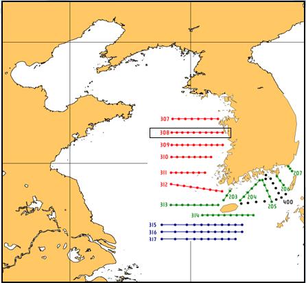
3 Chinese Operational Hydrological Forecasting System 1. Northwest Pacific 2. South China Sea 3. East China Sea 4. Bohai Sea 1 OGCM Horizontal Res. ROMS 1/20 o 1/30 o 1/30 o 1/60 o 4 2 Vertical Res. 30 levels 36 levels 30 levels 30 levels Atmosphere Forcing Assimilation Scheme 3D- VAR GFS/CGOGS-wind/NMEFC-WRF Nudging/EnOI Nudging SST MGDSST 3 OB S SSH Other s Jason-1 & Jason-2, Cryosat, SARAL and HY2 In-situ temperature and salinity profiles, e.g. Argos, XBTs Products Forecast Range Update Frequency Temperature, Salinity, Currents 5 days Daily
4 02 Operational Ocean Forecasting Systems

5 2.1 North-west Pacific Model Configuration Region Resolution Time Steps Boundary Condition 8 o S~52 o N;99 o E~160 o E 1/20 o 1/20 o 30 σ-levels Internal 180s;External 6s MOM4 global ocean forecasting system Hindcast Forcing Clim Data Topo Data GFSR 4 daily data SODA climatology data GEBCO(0.5' 0.5'), with observation data corrected in East China Sea


 from")

6 Model Validation Sea Water Level at (120 W, 20 N) from 1992 to 2011 Modeling Obs U v

7 Products of NwPM Temperature / Salinity / Current
 30 sigma levels Bathymetric data: GEBCO & China Coastal data Boundary Data: SODA & NWP 10 tidal constituents (TPXO7) Forcing data: WRF(NMEFC)& GFS River")
8 2.2 East China Sea Model Configuration Based on ROMS, Research Area: 114 ~133 E,22 ~41 N Model Domain: the BoHai, YS and the ECS Resolution: 1/30 1/30 (3.5km) 30 sigma levels Bathymetric data: GEBCO & China Coastal data Boundary Data: SODA & NWP 10 tidal constituents (TPXO7) Forcing data: WRF(NMEFC)& GFS River Discharge: Yangtze River
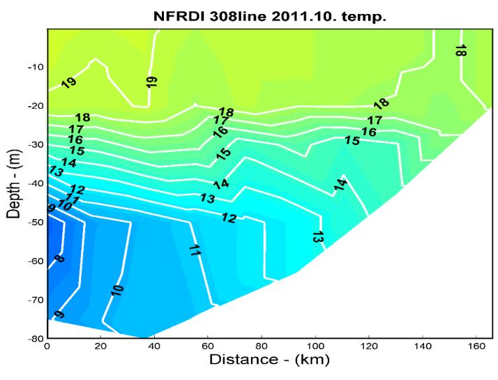
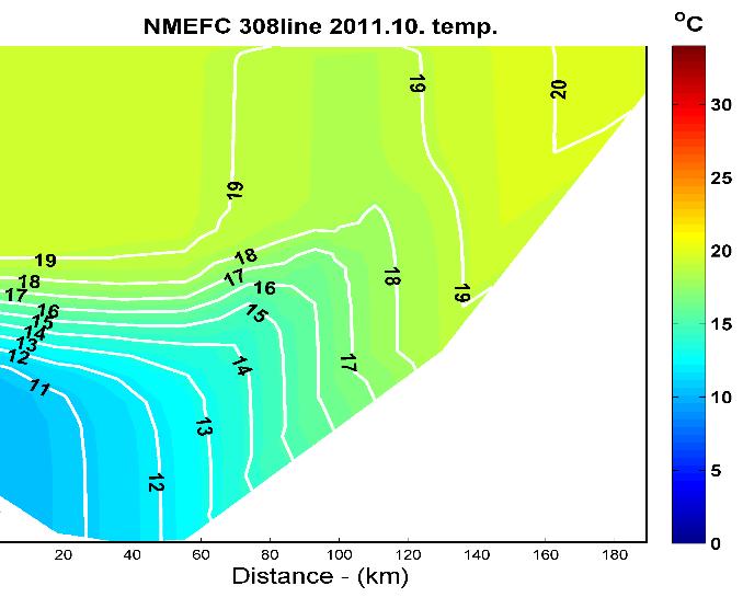
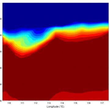
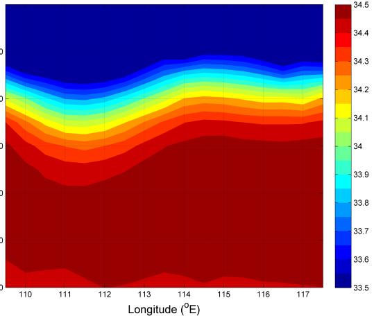
9 Model Validation Temperature from Section Data NFRDI observation MODEL OBS ECS r=0.89 U-component V-component

10 Products of ECSM Temperature / Salinity / Current

11 2.3 South China Sea Model Configuration Region -5 o N 26 o N 98 o E 140 o E Horizontal Resolution 1/30 Vertical Resolution Max Depth 6000 m Min Depth 10 m 36 Layers Topo ETOPO1
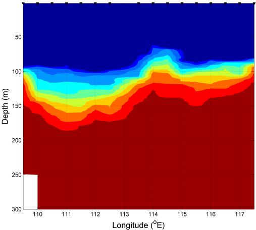


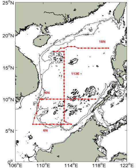

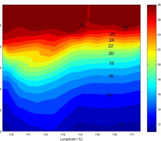
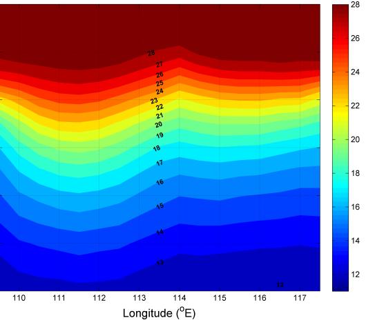
12 Model Validation Comparison with Obs. Aug. 9 ~ Sep. 8 10N 113E 18N Observation Mercator SCSOFS 6N Temp Salt

13 Products of SCSM Temperature / Salinity / Current

14 2.4 Bohai Sea Model Region 37 o S~41 o N;117.5 o E~112.5 o E Resolution 1/60 o 1/60 o 30 σ-levels Time Steps Internal 60s;External 2s Clim Data SODA climatology data Topo Data Observation Topography Data Boundary ECS climatology data

15 Products of BHSM Temperature / Salinity / Current


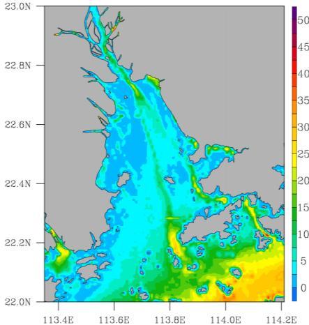
16 2.5 Daya Bay Coastal Model Region: ~116.7 E 20.4 ~23.0 N Resolution: < 200m Boundary: M 2 S 2 K 1 O 1 N 2 K 2 P 1 Q 1 Unstructured grid of the model
17 Model Validation M2 S2 K1 O1 Amp Pha Amp Pha Amp Pha Amp Pha Mod Obs Bias AE: 0.18 RE: 0.52 Bias: 0.05 SD: 0.19 Temporal evolution of sea level at Huizhou station. Blue line is observations, red line is simulations.

18 Model calibration Location of observation stations 实测 模拟 相对误差 流速 流向 流速 流向 流速 流向 % % % % % % % % % % % % % % % % 25
19 Forecast Validation S ~0.5psu T <1.0
20 03 Data Assimilation Scheme


21 Data Assimilation Scheme NwPM SLA Ensemble Optimal Interpolation ECSM SST Three Dimensional Variation SCSM Argo
22 RMSE( C) latitude EnOI Scheme Assimilation Method: EnOI Period: 2011/01/01~2011/12/31 Observation data for assimilation: OSTIA analysis SST product Assimilation cycle: 5 day (at 00:00) Parameter value: alpha=0.3,localization radius: R=150km 41 o N 40 o N 39 o N 38 o N 37 o N 36 o N 35 o N 34 o N o E 120 o E 122 o E 124 o E 126 o E longitude RMS error of Model SST against buoy temperature( C) RMSE of Model SST filed against OSTIA SST filed at 2011 Frer run EnOI Jan Feb Mar Apr May Jun Jul Aug Sep Oct Nov Dec Time(Month) RMS error of Model SST filed against OSTIA SST filed Buoy Free run EnOI improved (%) average

23 EnOI Scheme Schematic diagram of running ensemble-sampling at assimilation time t


 1")


24 3DVAR Scheme Data Assimilation of SST Method: 3D-Var Period: 2015/01/01 ~ now Observation data for assimilation: MGDSST (Merged satellite and in situ data Global Daily Sea Surface Temperatures, 1/4 1/4 ) Assimilation cycle: Daily (at 12:00 UTC) 1 st 2 nd 3 rd 4 th 5 th The Errors between simulations and observations Day ME AE RMSE 1 st nd rd th th

 Temperature at surface The 136 o E")


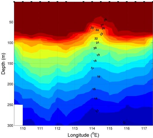
25 3DVAR Scheme Data Assimilation of Argo profiles Method: 3D-Var Period: TEST: 2006/01/01~2006/12/31; Operational Run: 2015/01/01~now. Observation data for assimilation: T/S Argos Profiles Assimilation cycle: Daily (at 00:00 UTC) Temperature at surface The 136 o E section: Temperature Salinity at 150m The 136 o E section: Salinity For temperature, the RMSE decreases from C in the SF run to C in the AF run, i.e. a 37.21% reduction occurs. For salinity, the RMSE decreases from in the SF run to in the AF run, i.e. a 27.98% reductions.
26 04 Ocean Services


27 Ocean Services Search and Rescue chemicals spill analysis Oil Spill Carbon Cycle OOFS Escort Mission Coastal Tourist Destinations Forecasts Submersible Jiaolong Exploration South China Sea Model


")


28 Search and Rescue Forecasts for trajectory of vessels lost motion and drowning person Missing Malaysian flight MH370 emergency forecasting (On March 8, 2014) Emergency forecasting of search and rescue in Xisha islands sea area (On September 29, 2013, "Butterfly Typh" )


29 Marine hazardous materials transport 8 12 Tianjin Port hazardous materials transport analysis 1. To simulate the surface current Irregular semi-diurnal tides in Bohai bay; Westward at high tide and eastward at low tide in Tianjin Port coastal area. 2. Supposing the chemicals spilled from Sewage outlet to the sea, To forecast the marine area of influence in 72hours. The concentration diffusion process was simulated on high resolution current. Daily mean Bohai Bay Bohai Bay High tide UTC+8 Low tide UTC+8 Tianjin Port explosion Tianjin Port explosion


30 Carbon Cycle pco ecological model and forecast experiment
 City Wave Temperature City Wave Temperatur")


31 Environmental Forecasts Forecasts for Travel Channel ( ) City Wave Temperature City Wave Temperatur e Da Lian Slight 10.7 Maldives Moderate 29.0 Vladivostok Slight 5.9 Cape Town Moderate 16.2 Jeju 17.7 Rio de Moderate 24.2 Slight Janeiro Tokyo Slight 18.4 Lisbon Moderate 17.9 Shanghai Slight 19.1 Barcelona Slight 16.6 Keelung Slight 24.9 Bergen Rough 8.3 San Ya Slight 28.8 Hamburger Very Rough 11.2 Hong Kong Slight 25.8 San Rough 11.6 Francisco Bangkok Slight 31.0 New York Slight 13.0 Singapore Slight 30.9 Sydney Slight 22.4 Dubai Slight 27.7 Hawaii Moderate 25.8 Submersible Jiaolong Exploration Escort Mission in the Strait of Malacca


32 Hong Kong-Zhuhai-Macau/Macao Bridge :00 19:00 20:00 21:00 22:00 23:00 0:00 1:00 2:00 3:00 4:00 5:00 6:00 7:00 8:00 9:00 10:00 11:00 12:00 13:00 14:00 15:00 16:00 17:00 18:00 19:00 20:00 21:00 22:00 23:00 0:00 1:00 2:00 3:00 4:00 5:00 6:00 7:00 8:00 9:00 10:00 11:00 12:00 13:00 14:00 15:00 16:00 17:00 18:00 19:00 20:00 21:00 22:00 23:00 0:00 1:00 2:00 3:00 4:00 5:00 6:00 7:00 8:00 9:00 10:00 11:00 12:00 13:00 14:00 15:00 16:00 17:00 4# model

33 05 Summary

34 Summary The Operational Ocean Forecasting System of China Sea, which include Northwest Pacific Model, East China Sea Model and South China Sea Model, has been used for operational forecasting everyday The release of Operational Ocean Forecasting System have been applied well to ecological, oil spill forecasting, search and rescue, such as chlorophyll-a, nutrients in the north Pacific, CO 2 flux in the northwest Pacific Ocean, oil explosion in coastal areas, searching for MH370, and so on. 03 In the further work, extension of forecast range, development of forecast system with independent intellectual property, construction of observation system will be considered more and more.
35
Data Assimilation of Argo Profiles in Northwest Pacific Yun LI National Marine Environmental Forecasting Center, Beijing
 Data Assimilation of Argo Profiles in Northwest Pacific Yun LI National Marine Environmental Forecasting Center, Beijing www.nmefc.gov.cn National Marine Environmental Forecasting Center Established in
Application and improvement of Ensemble Optimal Interpolation on Regional Ocean Modeling System (ROMS)
") Application and improvement of Ensemble Optimal Interpolation on Regional Ocean Modeling System (ROMS) Zhaoyi Wang Guokun Lyu, Hui Wang, Jiang Zhu, Guimei Liu et al. National Marine Environmental Forecasting
Application and improvement of Ensemble Optimal Interpolation on Regional Ocean Modeling System (ROMS) Zhaoyi Wang Guokun Lyu, Hui Wang, Jiang Zhu, Guimei Liu et al. National Marine Environmental Forecasting
Developing Coastal Ocean Forecasting Systems and Their Applications
 Developing Coastal Ocean Forecasting Systems and Their Applications Xiaochun Wang a,b LASG/IAP, CAS, July 23, 2010 Contributions from: JPL Yi Chao, John Farrara, Peggy Li, Zhijin Li, Quoc Vu, Hongchun
Assimilation Impact of Physical Data on the California Coastal Ocean Circulation and Biogeochemistry
 Assimilation Impact of Physical Data on the California Coastal Ocean Circulation and Biogeochemistry Yi Chao, Remote Sensing Solutions (RSS)/UCLA; John D. Farrara, RSS; Fei Chai, University of Maine; Hongchun
A Modeling Study on Flows in the Strait of Hormuz (SOH)
") A Modeling Study on Flows in the Strait of Hormuz (SOH) Peter C Chu & Travis Clem Naval Postgraduate School Monterey, CA 93943, USA IUGG 2007: PS005 Flows and Waves in Straits. July 5-6, Perugia, Italy
A Modeling Study on Flows in the Strait of Hormuz (SOH) Peter C Chu & Travis Clem Naval Postgraduate School Monterey, CA 93943, USA IUGG 2007: PS005 Flows and Waves in Straits. July 5-6, Perugia, Italy
The High Resolution Global Ocean Forecasting System in the NMEFC and its Intercomparison with the GODAE OceanView IV-TT Class 4 Metrics
 The High Resolution Global Ocean Forecasting System in the NMEFC and its Intercomparison with the GODAE OceanView IV-TT Class 4 Metrics Liying Wan (Group Leader) Yu Zhang, Huier Mo, Ziqing Zu, Yinghao
Storm surge forecasting and other Met Office ocean modelling
 Storm surge forecasting and other Met Office ocean modelling EMODnet stakeholder meeting Clare O Neill + many others Outline Ocean modelling at the Met Office Storm surge forecasting Current operational
GFDL, NCEP, & SODA Upper Ocean Assimilation Systems
 GFDL, NCEP, & SODA Upper Ocean Assimilation Systems Jim Carton (UMD) With help from Gennady Chepurin, Ben Giese (TAMU), David Behringer (NCEP), Matt Harrison & Tony Rosati (GFDL) Description Goals Products
Development of a coastal monitoring and forecasting system at MRI/JMA
 COSS-TT and ARCOM Development of a coastal monitoring and forecasting system at MRI/JMA N. USUI, Y. Fujii, K, Sakamoto, H. Tsujino, T. Kuragano & Masa KAMACHI Meteorological Research Institute, Japan Sept
Improving the initialisation of our operational shelf-seas models
 Improving the initialisation of our operational shelf-seas models Robert King James While, Matt Martin, Dan Lean, Jennie Waters, Enda O Dea, Jenny Graham NPOP May 2018 Contents 1. Recent history developments
Initial Results of Altimetry Assimilation in POP2 Ocean Model
 Initial Results of Altimetry Assimilation in POP2 Ocean Model Svetlana Karol and Alicia R. Karspeck With thanks to the DART Group, CESM Software Development Group, Climate Modeling Development Group POP-DART
GODAE Ocean View Activities in JMA (and Japan)
") GOVST VIII, Nov. 6 th, 2017, Bergen, Norway GODAE Ocean View Activities in JMA (and Japan) Yosuke Fujii 1, Norihisa Usui 1, Takahiro Toyoda 1, Nariaki Hirose 1, Hiromichi Igarashi 2, and Japan GODAE group
GOVST VIII, Nov. 6 th, 2017, Bergen, Norway GODAE Ocean View Activities in JMA (and Japan) Yosuke Fujii 1, Norihisa Usui 1, Takahiro Toyoda 1, Nariaki Hirose 1, Hiromichi Igarashi 2, and Japan GODAE group
The Improvement of JMA Operational Wave Models
 The Improvement of JMA Operational Wave Models Toshiharu Tauchi Nadao Kohno * Mika Kimura Japan Meteorological Agency * (also) Meteorological Research Institute, JMA 10 th International Workshop on Wave
Applications of an ensemble Kalman Filter to regional ocean modeling associated with the western boundary currents variations
 Applications of an ensemble Kalman Filter to regional ocean modeling associated with the western boundary currents variations Miyazawa, Yasumasa (JAMSTEC) Collaboration with Princeton University AICS Data
The CONCEPTS Global Ice-Ocean Prediction System Establishing an Environmental Prediction Capability in Canada
 The CONCEPTS Global Ice-Ocean Prediction System Establishing an Environmental Prediction Capability in Canada WWOSC 2014 Montreal, Quebec, Canada Dorina Surcel Colan 1, Gregory C. Smith 2, Francois Roy
Implementation of the SEEK filter in HYCOM
 Implementation of the SEEK filter in HYCOM P. Brasseur, J. Verron, J.M. Brankart LEGI/CNRS, Grenoble, France HYCOM model SST, SSH, ocean colour Assimilation SEEK filter Y H x f In situ, XBT K x a Real-time
ECMWF: Weather and Climate Dynamical Forecasts
 ECMWF: Weather and Climate Dynamical Forecasts Medium-Range (0-day) Partial coupling Extended + Monthly Fully coupled Seasonal Forecasts Fully coupled Atmospheric model Atmospheric model Wave model Wave
The ECMWF coupled data assimilation system
 The ECMWF coupled data assimilation system Patrick Laloyaux Acknowledgments: Magdalena Balmaseda, Kristian Mogensen, Peter Janssen, Dick Dee August 21, 214 Patrick Laloyaux (ECMWF) CERA August 21, 214
GAMINGRE 8/1/ of 7
 FYE 09/30/92 JULY 92 0.00 254,550.00 0.00 0 0 0 0 0 0 0 0 0 254,550.00 0.00 0.00 0.00 0.00 254,550.00 AUG 10,616,710.31 5,299.95 845,656.83 84,565.68 61,084.86 23,480.82 339,734.73 135,893.89 67,946.95
Aquarius Data Release V2.0 Validation Analysis Gary Lagerloef, Aquarius Principal Investigator H. Kao, ESR And Aquarius Cal/Val Team
 Aquarius Data Release V2.0 Validation Analysis Gary Lagerloef, Aquarius Principal Investigator H. Kao, ESR And Aquarius Cal/Val Team Analysis period: Sep 2011-Dec 2012 SMOS-Aquarius Workshop 15-17 April
The Coupled Earth Reanalysis system [CERA]
![The Coupled Earth Reanalysis system [CERA]](/thumbs/95/122770734.jpg "The Coupled Earth Reanalysis system [CERA]") The Coupled Earth Reanalysis system [CERA] Patrick Laloyaux Acknowledgments: Eric de Boisséson, Magdalena Balmaseda, Dick Dee, Peter Janssen, Kristian Mogensen, Jean-Noël Thépaut and Reanalysis Section
The Coupled Earth Reanalysis system [CERA] Patrick Laloyaux Acknowledgments: Eric de Boisséson, Magdalena Balmaseda, Dick Dee, Peter Janssen, Kristian Mogensen, Jean-Noël Thépaut and Reanalysis Section
Life Cycle of Convective Systems over Western Colombia
 Life Cycle of Convective Systems over Western Colombia Meiry Sakamoto Uiversidade de São Paulo, São Paulo, Brazil Colombia Life Cycle of Convective Systems over Western Colombia Convective System (CS)
WIND EFFECTS ON CHEMICAL SPILL IN ST ANDREW BAY SYSTEM
 WIND EFFECTS ON CHEMICAL SPILL IN ST ANDREW BAY SYSTEM PETER C. CHU, PATRICE PAULY Naval Postgraduate School, Monterey, CA93943 STEVEN D. HAEGER Naval Oceanographic Office, Stennis Space Center MATHEW
Comparison between vertical shear mixing and surface wave-induced mixing in the global ocean
 Comparison between vertical shear mixing and surface wave-induced mixing in the global ocean Fangli Qiao and Chuanjiang Huang Key Laboratory of Marine Science and Numerical Modeling First Institute of
Evaluation of the sea ice forecast at DMI
 DMI Evaluation of the sea ice forecast at DMI Till A. S. Rasmussen 1 Kristine S. Madsen 1, Mads H. Ribergaard 1, Leif T.Pedersen 1, Jacob L Høyer 1, Gorm Dybkjær 1, Mads Bruun Poulsen 2 and Sofie Abildgaard
How DBCP Data Contributes to Ocean Forecasting at the UK Met Office
 How DBCP Data Contributes to Ocean Forecasting at the UK Met Office Ed Blockley DBCP XXVI Science & Technical Workshop, 27 th September 2010 Contents This presentation covers the following areas Introduction
Supplementary appendix
 Supplementary appendix This appendix formed part of the original submission and has been peer reviewed. We post it as supplied by the authors. Supplement to: Lowe R, Stewart-Ibarra AM, Petrova D, et al.
PREDICTION OF OIL SPILL TRAJECTORY WITH THE MMD-JMA OIL SPILL MODEL
 PREDICTION OF OIL SPILL TRAJECTORY WITH THE MMD-JMA OIL SPILL MODEL Project Background Information MUHAMMAD HELMI ABDULLAH MALAYSIAN METEOROLOGICAL DEPARTMENT(MMD) MINISTRY OF SCIENCE, TECHNOLOGY AND INNOVATION
Feature resolution in OSTIA L4 analyses. Chongyuan Mao, Emma Fiedler, Simon Good, Jennie Waters, Matthew Martin
 Feature resolution in OSTIA L4 analyses Chongyuan Mao, Emma Fiedler, Simon Good, Jennie Waters, Matthew Martin GHRSST XVIII, Qingdao, China, 5-9 June 2017 Talk outline Introduction NEMOVAR in OSTIA Methods
Discussion of forcing errors in the Bay and how to deal with these using the LETKF. Assimilation with synthetic obs with realistic coverage
 Discussion of forcing errors in the Bay and how to deal with these using the LETKF Assimilation with synthetic obs with realistic coverage Ecologically and economically important resource Home to over
Ocean data assimilation systems in JMA and their representation of SST and sea ice fields
 SST-WS, Jan. 6 th, 2018, ECMWF, Reading, UK Ocean data assimilation systems in JMA and their representation of SST and sea ice fields Yosuke Fujii 1, Takahiro Toyoda 1, Norihisa Usui 1, Nariaki Hirose
Observations assimilated
 Observations assimilated R-factor to adjust model error variances and K-Factor to adjust observation error variances. ETKF employs SST and SLA bias correction via AR() model fit. TABLE Summary of ocean
Yi Chao Jet Propulsion Laboratory California Institute of Technology & Joint Institute for Regional Earth System Science and Engineering (JIFRESSE)
") Strategy to Develop a 3D Ocean Circulation Forecasting System for Cook Inlet Yi Chao Jet Propulsion Laboratory California Institute of Technology & Joint Institute for Regional Earth System Science and
Strategy to Develop a 3D Ocean Circulation Forecasting System for Cook Inlet Yi Chao Jet Propulsion Laboratory California Institute of Technology & Joint Institute for Regional Earth System Science and
BMKG Research on Air sea interaction modeling for YMC
 BMKG Research on Air sea interaction modeling for YMC Prof. Edvin Aldrian Director for Research and Development - BMKG First Scientific and Planning Workshop on Year of Maritime Continent, Singapore 27-3
NCODA Implementation with re-layerization
 NCODA Implementation with re-layerization HeeSook Kang CIMAS/RSMAS/U. Miami with W. Carlisle Thacker NOAA/AOML HYCOM meeting December 6 2005 1 GULF OF MEXICO MODEL CONFIGURATION: Horizontal grid: 1/12
An Overview of Atmospheric Analyses and Reanalyses for Climate
 An Overview of Atmospheric Analyses and Reanalyses for Climate Kevin E. Trenberth NCAR Boulder CO Analysis Data Assimilation merges observations & model predictions to provide a superior state estimate.
OSSE OSE activities with Multivariate Ocean VariationalEstimation (MOVE)System. II:Impacts ofsalinity and TAO/TRITON.
System. II:Impacts ofsalinity and TAO/TRITON.") G ODAE/O O P O SSE O SE m eeting,nov.5 7th,2007 in IO,Paris OSSE OSE activities with Multivariate Ocean VariationalEstimation (MOVE)System. II:Impacts ofsalinity and TAO/TRITON. S.Matsumoto,Y.Fujii,T.Soga,T.Yasuda,S.Ishizaki,N.Usui,and
G ODAE/O O P O SSE O SE m eeting,nov.5 7th,2007 in IO,Paris OSSE OSE activities with Multivariate Ocean VariationalEstimation (MOVE)System. II:Impacts ofsalinity and TAO/TRITON. S.Matsumoto,Y.Fujii,T.Soga,T.Yasuda,S.Ishizaki,N.Usui,and
Introduction of Korea Operational Oceanographic System (KOOS)
") PICES-2010, Portland, USA October 21-31, 2010 Introduction of Korea Operational Oceanographic System (KOOS) Oct. 28, 2010 Kwang-Soon Park, Dong-Young Lee, Ki-Cheon Jun, Sang-Ik Kim, Jae-Il Kwon and Jung-Woon
PICES-2010, Portland, USA October 21-31, 2010 Introduction of Korea Operational Oceanographic System (KOOS) Oct. 28, 2010 Kwang-Soon Park, Dong-Young Lee, Ki-Cheon Jun, Sang-Ik Kim, Jae-Il Kwon and Jung-Woon
Name Period Part I: INVESTIGATING OCEAN CURRENTS: PLOTTING BUOY DATA
 Name Period Part I: INVESTIGATING OCEAN CURRENTS: PLOTTING BUOY DATA INTRODUCTION: Ocean currents are like huge rivers in the sea. They carry drifting organisms, vital dissolved chemical nutrients and
Assimilation of SST data in the FOAM ocean forecasting system
 Assimilation of SST data in the FOAM ocean forecasting system Matt Martin, James While, Dan Lea, Rob King, Jennie Waters, Ana Aguiar, Chris Harris, Catherine Guiavarch Workshop on SST and Sea Ice analysis
Lu, S., P. Craig, C. Wallen, Z. Liu, A. Stoddard, W. McAnnally and E. Maak. Dynamic Solutions, Knoxville, TN USACOE, Sacramento District
 An Extended-Delta Hydrodynamic Model Framework for Sea Level Rise Analysis to Support Resource Management Planning for the Sacramento-San Joaquin River Delta Lu, S., P. Craig, C. Wallen, Z. Liu, A. Stoddard,
Ocean data assimilation for reanalysis
 Ocean data assimilation for reanalysis Matt Martin. ERA-CLIM2 Symposium, University of Bern, 14 th December 2017. Contents Introduction. On-going developments to improve ocean data assimilation for reanalysis.
Sea Ice Forecast Verification in the Canadian Global Ice Ocean Prediction System
 Sea Ice Forecast Verification in the Canadian Global Ice Ocean Prediction System G Smith 1, F Roy 2, M Reszka 2, D Surcel Colan, Z He 1, J-M Belanger 1, S Skachko 3, Y Liu 3, F Dupont 2, J-F Lemieux 1,
Yellow Sea Thermohaline and Acoustic Variability
 Yellow Sea Thermohaline and Acoustic Variability Peter C Chu, Carlos J. Cintron Naval Postgraduate School, USA Steve Haeger Naval Oceanographic Office, USA Yellow Sea Bottom Sediment Chart Four Bottom
Eddy and Chlorophyll-a Structure in the Kuroshio Extension Detected from Altimeter and SeaWiFS
 14th Symposium on Integrated Observing and Assimilation Systems for the Atmosphere, Oceans, and Land Surface (IOAS-AOLS), AMS Atlanta, January 17-21, 21 Eddy and Chlorophyll-a Structure in the Kuroshio
Collaborative Proposal to Extend ONR YIP research with BRC Efforts
 Collaborative Proposal to Extend ONR YIP research with BRC Efforts Brian Powell, Ph.D. University of Hawaii 1000 Pope Rd., MSB Honolulu, HI 968 phone: (808) 956-674 fax: (808) 956-95 email:powellb@hawaii.edu
Convective-scale NWP for Singapore
 Convective-scale NWP for Singapore Hans Huang and the weather modelling and prediction section MSS, Singapore Dale Barker and the SINGV team Met Office, Exeter, UK ECMWF Symposium on Dynamical Meteorology
Coastal Data Assimilation: progress and challenges in state estimation for circulation and BGC models
 Coastal Data Assimilation: progress and challenges in state estimation for circulation and BGC models Emlyn Jones, Roger Scott, Mark Baird, Frank Colberg, Paul Sandery, Pavel Sakov, Gary Brassington, Mathieu
Performance of a 23 years TOPAZ reanalysis
 Performance of a 23 years TOPAZ reanalysis L. Bertino, F. Counillon, J. Xie,, NERSC LOM meeting, Copenhagen, 2 nd -4 th June 2015 Outline Presentation of the TOPAZ4 system Choice of modeling and assimilation
Seasonal Simulaions of a coupled ice-ocean model in the Bohai Sea and North Yellow Sea
 Seasonal Simulaions of a coupled ice-ocean model in the Bohai Sea and North Yellow Sea Yu LIU,Qinzheng LIU,Jie Su*, Shan BAI,Maoning Tang National Marine Environmental Forecasting Center * Ocean University
Demonstration and Comparison of of Sequential Approaches for Altimeter Data Assimilation in in HYCOM
 Demonstration and Comparison of of Sequential Approaches for Altimeter Data Assimilation in in HYCOM A. Srinivasan, E. P. Chassignet, O. M. Smedstad, C. Thacker, L. Bertino, P. Brasseur, T. M. Chin,, F.
Enhancing predictability of the Loop Current variability using Gulf of Mexico Hycom
 Enhancing predictability of the Loop Current variability using Gulf of Mexico Hycom Matthieu Le Hénaff (1) Villy Kourafalou (1) Ashwanth Srinivasan (1) Collaborators: O. M. Smedstad (2), P. Hogan (2),
ENSO Outlook by JMA. Hiroyuki Sugimoto. El Niño Monitoring and Prediction Group Climate Prediction Division Japan Meteorological Agency
 ENSO Outlook by JMA Hiroyuki Sugimoto El Niño Monitoring and Prediction Group Climate Prediction Division Outline 1. ENSO impacts on the climate 2. Current Conditions 3. Prediction by JMA/MRI-CGCM 4. Summary
Operational Estuarine & Coastal Forecast Systems in NOAA s. National Ocean Service
 Operational Estuarine & Coastal Forecast Systems in NOAA s. National Ocean Service Eugene Wei, Frank Aikman III and Richard Patchen NOAA S S National Ocean Service Workshop on: Data Assimilation in Support
Overview of data assimilation in oceanography or how best to initialize the ocean?
 Overview of data assimilation in oceanography or how best to initialize the ocean? T. Janjic Alfred Wegener Institute for Polar and Marine Research Bremerhaven, Germany Outline Ocean observing system Ocean
Regional High Resolution Reanalysis over European North East Shelf domain
 Regional High Resolution Reanalysis over European North East Shelf domain M. Benkiran, E. Greiner (CLS) and Mercator Ocean Team http://www.mercator-ocean.fr mbenkiran@cls.fr 1 Outline REANALYSIS : IBI-1/12,
Operational Use of Scatterometer Winds at JMA
 Operational Use of Scatterometer Winds at JMA Masaya Takahashi Numerical Prediction Division, Japan Meteorological Agency (JMA) 10 th International Winds Workshop, Tokyo, 26 February 2010 JMA Outline JMA
Impact of Argo, SST, and altimeter data on an eddy-resolving ocean reanalysis
 Click Here for Full Article GEOPHYSICAL RESEARCH LETTERS, VOL. 34, L19601, doi:10.1029/2007gl031549, 2007 Impact of Argo, SST, and altimeter data on an eddy-resolving ocean reanalysis Peter R. Oke 1 and
O.M Smedstad 1, E.J. Metzger 2, R.A. Allard 2, R. Broome 1, D.S. Franklin 1 and A.J. Wallcraft 2. QinetiQ North America 2. Naval Research Laboratory
 An eddy-resolving ocean reanalysis using the 1/12 global HYbrid Coordinate Ocean Model (HYCOM) and the Navy Coupled Ocean Data Assimilation (NCODA) scheme O.M Smedstad 1, E.J. Metzger 2, R.A. Allard 2,
Shuhei Maeda Climate Prediction Division Global Environment and Marine Department Japan Meteorological Agency
 Eighth Session of the Forum on Regional Climate Monitoring, Assessment and Prediction for Asia (FOCRAII) 5-7 April 2012, Beijing, China Shuhei Maeda Climate Prediction Division Global Environment and Marine
CERA-SAT: A coupled reanalysis at higher resolution (WP1)
") CERA-SAT: A coupled reanalysis at higher resolution (WP1) ERA-CLIM2 General assembly Dinand Schepers 16 Jan 2017 Contributors: Eric de Boisseson, Per Dahlgren, Patrick Lalolyaux, Iain Miller and many others
CERA-SAT: A coupled reanalysis at higher resolution (WP1) ERA-CLIM2 General assembly Dinand Schepers 16 Jan 2017 Contributors: Eric de Boisseson, Per Dahlgren, Patrick Lalolyaux, Iain Miller and many others
Changes in spatial distribution of chub mackerel under climate change: the case study using Japanese purse seine fisheries data in the East China Sea
 Changes in spatial distribution of chub mackerel under climate change: the case study using Japanese purse seine fisheries data in the East China Sea Tohya Yasuda, Ryuji Yukami, Seiji Ohshimo Seikai National
The impact of combined assimilation of altimeters data and wave spectra from S-1A and 1B in the operational model MFWAM
 The impact of combined assimilation of altimeters data and wave spectra from S-1A and 1B in the operational model MFWAM Lotfi Aouf and Alice Dalphinet Météo-France, Département Marine et Oceanographie
Recent improvements on the wave forecasting system of Meteo-France: modeling and assimilation aspects
 Recent improvements on the wave forecasting system of Meteo-France: modeling and assimilation aspects L. Aouf and J-M. Lefèvre Division Marine et Océanographie, Météo-France 13 th International workshop
FORA-WNP30. FORA_WNP30_JAMSTEC_MRI DIAS en
 FORA-WNP30 1. TITLE Edition 1.0 Metadata Identifier 2. CONTACT FORA-WNP30 2.1 CONTACT on DATASET FORA_WNP30_JAMSTEC_MRI20160708144420-DIAS20160706142617-en Address JAMSTEC/CEIST 3173-25, Showa-machi, Kanazawa-ku,
Eddy Shedding from the Kuroshio Bend at Luzon Strait
 Journal of Oceanography, Vol. 60, pp. 1063 to 1069, 2004 Short Contribution Eddy Shedding from the Kuroshio Bend at Luzon Strait YINGLAI JIA* and QINYU LIU Physical Oceanography Laboratory and Ocean-Atmosphere
Coastal Inundation Forecasting and Community Response in Bangladesh
 WMO Coastal Inundation Forecasting and Community Response in Bangladesh Bapon (SHM) Fakhruddin Nadao Kohno 12 November 2015 System Design for Coastal Inundation Forecasting CIFDP-PSG-5, 14-16 May 2014,
4DVAR Data Assimilation with Chesapeake Bay Operational Forecasting System
 4DVAR Data Assimilation with Chesapeake Bay Operational Forecasting System Bin Zhang 1, Matt Hoffman 2, Lyon Lanerolle 3, Chris Brown 1,4 1 Cooperative Institute of Climate & Satellites/Earth System Science
Atmospheric circulation analysis for seasonal forecasting
 Training Seminar on Application of Seasonal Forecast GPV Data to Seasonal Forecast Products 18 21 January 2011 Tokyo, Japan Atmospheric circulation analysis for seasonal forecasting Shotaro Tanaka Climate
Sea Level Variability in the Western North Pacific during the 20th Century
 Sea Level Variability in the Western North Pacific during the 20th Century Yoshi N. Sasaki (sasakiyo@sci.hokudai.ac.jp), R. Washizu, S. Minobe Hokkaido University, Japan T. Yasuda: Japan Meteorological
Comparison of of Assimilation Schemes for HYCOM
 Comparison of of Assimilation Schemes for HYCOM Ashwanth Srinivasan, C. Thacker, Z. Garraffo, E. P. Chassignet, O. M. Smedstad, J. Cummings, F. Counillon, L. Bertino, T. M. Chin, P. Brasseur and C. Lozano
AN INTEGRATED MODELING APPROACH FOR SIMULATING OIL SPILL AT THE STRAIT OF BOHAI SEA. Jinhua Wang 1 and Jinshan Zhang 1
 AN INTEGRATED MODELING APPROACH FOR SIMULATING OIL SPILL AT THE STRAIT OF BOHAI SEA Jinhua Wang 1 and Jinshan Zhang 1 A three dimensional integrated model is developed for simulating oil spills transport
HYCOM Caspian Sea Modeling. Part I: An Overview of the Model and Coastal Upwelling. Naval Research Laboratory, Stennis Space Center, USA
 HYCOM Caspian Sea Modeling. Part I: An Overview of the Model and Coastal Upwelling By BIROL KARA, ALAN WALLCRAFT AND JOE METZGER Naval Research Laboratory, Stennis Space Center, USA MURAT GUNDUZ Institute
Model and observation bias correction in altimeter ocean data assimilation in FOAM
 Model and observation bias correction in altimeter ocean data assimilation in FOAM Daniel Lea 1, Keith Haines 2, Matt Martin 1 1 Met Office, Exeter, UK 2 ESSC, Reading University, UK Abstract We implement
Inter comparison of wave height observations from buoy and altimeter with numerical prediction
 Indian Journal of Geo-Marine Sciences Vol. 43(7), July 2014, pp. 1347-1351 Inter comparison of wave height observations from buoy and altimeter with numerical prediction S. A. Sannasiraj 1*, M. Kalyani
Indian Ocean Forecast System (INDOFOS) Abhisek Chatterjee
 Abhisek Chatterjee") Indian Ocean Forecast System (INDOFOS) Abhisek Chatterjee Earth System Sciences Organisation (ESSO) Indian National Centre for Ocean Information Services (INCOIS) Ministry of Earth Sciences, Government
Indian Ocean Forecast System (INDOFOS) Abhisek Chatterjee Earth System Sciences Organisation (ESSO) Indian National Centre for Ocean Information Services (INCOIS) Ministry of Earth Sciences, Government
Recent Data Assimilation Activities at Environment Canada
 Recent Data Assimilation Activities at Environment Canada Major upgrade to global and regional deterministic prediction systems (now in parallel run) Sea ice data assimilation Mark Buehner Data Assimilation
Sensitivity of Satellite Altimetry Data Assimilation on a Naval Anti-Submarine Warfare Weapon System
 Sensitivity of Satellite Altimetry Data Assimilation on a Naval Anti-Submarine Warfare Weapon System Steven Mancini LCDR, USN Advisor: Prof. Peter Chu Second Readers: Dr. Charlie Barron Eric Gottshall,
An Update on the 1/12 Global HYCOM Effort
 An Update on the 1/12 Global HYCOM Effort E. Joseph Metzger, Alan J. Wallcraft, Jay F. Shriver and Harley E. Hurlburt Naval Research Laboratory 10 th HYCOM Consortium Meeting 7-99 November 2006 FSU-COAPS,
Zorana Jelenak Paul S. Chang Khalil Ahmed (OPC) Seubson Soisuvarn Qi Zhu NOAA/NESDIS/STAR-UCAR
 Seubson Soisuvarn Qi Zhu NOAA/NESDIS/STAR-UCAR") Near Real Time ASCAT Wind Vectors at NOAA and High Wind Issue Zorana Jelenak Paul S. Chang Khalil Ahmed (OPC) Seubson Soisuvarn Qi Zhu NOAA/NESDIS/STAR-UCAR ASCAT Wind Processing Implemented at NOAA Feb
Near Real Time ASCAT Wind Vectors at NOAA and High Wind Issue Zorana Jelenak Paul S. Chang Khalil Ahmed (OPC) Seubson Soisuvarn Qi Zhu NOAA/NESDIS/STAR-UCAR ASCAT Wind Processing Implemented at NOAA Feb
Ocean Observations for an End-to-End Seasonal Forecasting System
 Ocean Observations for an End-to-End Seasonal Forecasting System Magdalena A. Balmaseda Yosuke Fujii Oscar Alves Tong Lee Michele Rienecker Tony Rosati Detlef Stammer Yan Xue Howard Freeland Michael McPhaden
FORA-WNP30. FORA_WNP30_JAMSTEC_MRI DIAS en
 FORA-WNP30 1. IDENTIFICATION INFORMATION Edition 1.0 Metadata Identifier 2. CONTACT FORA-WNP30 2.1 CONTACT on DATASET FORA_WNP30_JAMSTEC_MRI20170725130550-DIAS20170725102541-en Address JAMSTEC/CEIST 3173-25,
Global climate predictions: forecast drift and bias adjustment issues
 www.bsc.es Ispra, 23 May 2017 Global climate predictions: forecast drift and bias adjustment issues Francisco J. Doblas-Reyes BSC Earth Sciences Department and ICREA Many of the ideas in this presentation
Data assimilation for ocean climate studies
 Data assimilation for ocean climate studies James Carton, Gennady Chepurin, Steven Penny, and David Behringer (thanks Eugenia) University of Maryland, NOAA/NCEP, College Park, MD USA Chl concentration
PS4a: Real-time modelling platforms during SOP/EOP
 PS4a: Real-time modelling platforms during SOP/EOP Mistral Tramontane Bora Etesian Major sites of dense water formation Major sites of deep water formation influence of coastal waters Chairs: G. Boni,
Scarborough Tide Gauge
 Tide Gauge Location OS: 504898E 488622N WGS84: Latitude: 54 16' 56.990"N Longitude: 00 23' 25.0279"W Instrument Valeport 740 (Druck Pressure Transducer) Benchmarks Benchmark Description TGBM = 4.18m above
M. Liste 1, M. Grifoll 2, I. Keupers 1, J. Fernández 3, H. Ortega 1, J. Monbaliu 1
 M. Liste 1, M. Grifoll 2, I. Keupers 1, J. Fernández 3, H. Ortega 1, J. Monbaliu 1 1 Hydraulics Laboratory (K.U.Leuven, Belgium) 2 Laboratori d Enginyeria Marítima (LIM/UPC, Spain) 3 SIMO, Spain. Motivation
SOUTH AFRICAN TIDE TABLES
 SAN HO-2 2018 SOUTH AFRICAN TIDE TABLES PUBLISHED BY THE HYDROGRAPHER SOUTH AFRICAN NAVY PRIVATE BAG X1 TOKAI, 7966 COPYRIGHT RESERVED ISBN 978-0-9869717-9-2 CONTENTS Preface.... (iii) Tidal Levels......(iv)
What is the difference between Weather and Climate?
 What is the difference between Weather and Climate? Objective Many people are confused about the difference between weather and climate. This makes understanding the difference between weather forecasts
Surface Anomalies Prior to Earthquakes
 Surface Anomalies Prior to Earthquakes Habibeh Valizadeh, Shattri B. Mansor Husaini Omar and Farid Azad Department of Civil Engineering Universiti Putra Malaysia Serdang, Selangor Malaysia shattri@eng.upm.edu.my
Regional eddy-permitting state estimation of the circulation in the Northern Philippine Sea
 Regional eddy-permitting state estimation of the circulation in the Northern Philippine Sea Bruce D. Cornuelle, Ganesh Gopalakrishnan, Peter F. Worcester, Matthew A. Dzieciuch, and Matthew Mazloff Scripps
OPERATIONAL OCEAN FORECAST FOR THE NORTHERN IBERIA PENINSULA (OOF-NIP)
") OPERATIONAL OCEAN FORECAST FOR THE NORTHERN IBERIA PENINSULA (OOF-NIP) Investigación e Predición Numérica - MeteoGalicia - Consellería de Medio Ambiente e Ordenación do Territorio Xunta de Galicia Introduction
OPERATIONAL OCEAN FORECAST FOR THE NORTHERN IBERIA PENINSULA (OOF-NIP) Investigación e Predición Numérica - MeteoGalicia - Consellería de Medio Ambiente e Ordenación do Territorio Xunta de Galicia Introduction
Satellite-derived environmental drivers for top predator hotspots
 Satellite-derived environmental drivers for top predator hotspots Peter Miller @PeterM654 South West Marine Ecosystems 2017 21 Apr. 2017, Plymouth University Satellite environmental drivers for hotspots
The Mediterranean Operational Oceanography Network (MOON): Products and Services
: Products and Services") The Mediterranean Operational Oceanography Network (MOON): Products and Services The MOON consortia And Nadia Pinardi Co-chair of MOON Istituto Nazionale di Geofisica e Vulcanologia Department of Environmental
The Mediterranean Operational Oceanography Network (MOON): Products and Services The MOON consortia And Nadia Pinardi Co-chair of MOON Istituto Nazionale di Geofisica e Vulcanologia Department of Environmental
Responding to the 2016 and 2017 Mass Coral Bleaching events on the Great Barrier Reef: from Observations to Modelling
 Responding to the 2016 and 2017 Mass Coral Bleaching events on the Great Barrier Reef: from Observations to Modelling EMatson@aims Craig Steinberg & Claire Spillman N. Cantin, J. Benthuysen, H. Tonin,
Interannual Variability of Wind Induced Onshore Transport over the Northern West Florida Shelf
 Interannual Variability of Wind Induced Onshore Transport over the Northern West Florida Shelf Steve Morey Austin Todd Mark Bourassa COAPS/FSU Motivation Understand the physical controls on regional Gag
SST (NRL/NLOM, 28 Sept. 2004) (A global, surface layer product)
 (A global, surface layer product)") SST (NRL/NLOM, 28 Sept. 2004) (A global, surface layer product) SST (NRL/NLOM, 28 Sept. 2004) SST Forecast (NRL/NLOM, 20 Oct. 2004) UH/IPRC Asia-Pacific Data-Research Center (APDRC) Jay McCreary, Peter
SST (NRL/NLOM, 28 Sept. 2004) (A global, surface layer product) SST (NRL/NLOM, 28 Sept. 2004) SST Forecast (NRL/NLOM, 20 Oct. 2004) UH/IPRC Asia-Pacific Data-Research Center (APDRC) Jay McCreary, Peter
IAP Dynamical Seasonal Prediction System and its applications
 WCRP Workshop on Seasonal Prediction 4-7 June 2007, Barcelona, Spain IAP Dynamical Seasonal Prediction System and its applications Zhaohui LIN Zhou Guangqing Chen Hong Qin Zhengkun Zeng Qingcun Institute
GRADE 6 GEOGRAPHY TERM 1 LATITUDE AND LONGITUDE (degrees)
") 1 GRADE 6 GEOGRAPHY TERM 1 LATITUDE AND LONGITUDE (degrees) Contents Lines of Latitude... 2 Lines of Longitude... 3 The hemispheres of The Earth... 4 Finding countries and cities on a map using latitude
1 GRADE 6 GEOGRAPHY TERM 1 LATITUDE AND LONGITUDE (degrees) Contents Lines of Latitude... 2 Lines of Longitude... 3 The hemispheres of The Earth... 4 Finding countries and cities on a map using latitude
Global Ocean Monitoring: Recent Evolution, Current Status, and Predictions
 Global Ocean Monitoring: Recent Evolution, Current Status, and Predictions Prepared by Climate Prediction Center, NCEP November 6, 2009 http://www.cpc.ncep.noaa.gov/products/godas/ This project to deliver