Study on Air-Sea Interaction under Typhoon and Its Application of Two Important Projects
|
|
|
- Amice Hill
- 5 years ago
- Views:
Transcription

1 ESCAP/WMO Typhoon Committee Technical Conference (TC50 TECO) Study on Air-Sea Interaction under Typhoon and Its Application of Two Important Projects Li Yongping Shanghai Typhoon Institute/CMA


2 1 National Basic Research Program of China( ), STI/CMA,... Unusual Variation of Landfalling Tropical Cyclone Behavior and Associated Physical Mechanism 2 National Basic Research Program of China( ), SIO,STI. Study on Response of Upper Ocean and Mechanism of Modification to Typhoon
3 Contents Importance of Air-sea Interaction to TC Observations of Air-sea Interaction Some New Facts on Air-sea Interaction Improvement of TC Air-sea Coupled Model Numerical Sea Wave and Storm Surge Forecast
4 Chllenge: no progress for intensity forecast of TC h 48h 72h 96h 120h Track error of TC (CMA) Intensity error of TC (CMA)
5 OBS-GRAPES(m/s) Chllenge: Bias of intensity forecast of TC GRAPES_TCM 24h 预报 48h 预报 Strong bias (<30m/s) O B S(m/s) Weak bias (>50m/s)
6 Coupled Atmosphere-Ocean System Atmosphere heat flux wind stress Ocean no change for SST Cd= f(u10) before
7 Key Scientific Questions The response mechanism of multi-scale circulation in upper ocean to typhoon The dynamic and thermal structure of upper ocean to modulate the typhoon
8 Sub-projects and their relationship 1. Interaction between typhoon and mesoscale processes of ocean 2. Physical mechanism and parameterization of upper ocean affecting on typhoon 3. Low frequency response and modulation of ocean circulation to typhoon 4. Multi-source data integration and assimilation in typhoon conditions 5. The key technologies of typhoon strength and air-sea coupling prediction system
9 Contents Importance of Air-sea Interaction to TC Observations of Air-sea Interaction Some New Facts on Air-sea Interaction Improvement of TC Air-sea Coupled Model Numerical Sea Wave and Storm Surge Forecast


10 Maoming BoHe Marine meteorological science test base Weather Station at North Mountain:Boundary wind profile instrument; Radiometrics ;Sea wave radar;automatic weather station Platform on the sea: Ultrasonic wind thermometer; wind,temperature,humidity on 5 layers; Rain gauge; Infrared sea surface thermometer Blow sea surface:sea temperature and salinity on 3 layers;adcp Island:100 m tower wind,temperature, humidity on 5 layers; North Mountain weather station 6.5km Platform 100 m tower

11 BoHe Marine meteorological observation platform Air-sea flux observation Eddy covariance system Gradient observation system Radiation Doppler velocity Infrared telemeter for SST Temperature/salinity ultrasonic instrument
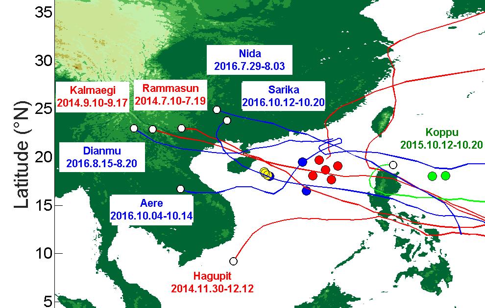


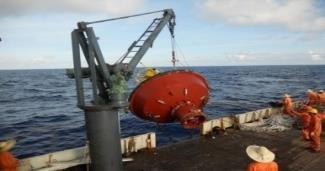

12 Buoy/submarine observation array


13 Other observations The rocket launched sounding underwater glider Satellite microwave sensing Argo
14 Contents Importance of Air-sea Interaction to TC Observations of Air-sea Interaction Some New Facts on Air-sea Interaction Improvement of TC Air-sea Coupled Model Numerical Sea Wave and Storm Surge Forecast
15 New air-sea exchange Cd changing with u10 under the typhoon Theoretical mechanism: waves broken by depth of water results in the curve of Cd moving toward low wind The phase velocity inhibition results in Cd increase Cd based on Bo He platform 15

16 A new parameterization scheme, the drag coefficient is dependent on the depth of the water km Numerical simulations Charnok: h Shallow water Track error of 22 TC cases in deep sea Large and Pong (1981,JPO)
17 Improvement of air-sea exchange coefficient algorithm C d C k Sea level pressure Wind speed at 10m
18 under the influence of the typhoon near shore sea surface temperature fell sharply 6 cooling at 63 km distance from typhoon center Wind speed, pressure and sea surface temperature by 0906TC date July,2009


 Day -7 Day 0 Day 10 Day")

19 The ocean responds and feedback to typhoons The upper ocean cooling by the typhoon The effect of BL depth on typhoon intensity The structure and strength of mesoscale vortex under a typhoon (SSHA) Day -7 Day 0 Day 10 Day 30 The effect of eddy position on typhoon intensity MSLP decrease if +SSTA at center and <R, outside not


20 Interaction between typhoons and ocean on large scale Modulation of PDO and ENSO to typhoon Modulation of the northern Indian Ocean to the western Pacific typhoon Impact of typhoon on west wind outbreak and ENSO Effects of typhoons on tropical circulation and thermal structure of ocean Chen D K
21 Contents Importance of Air-sea Interaction to TC Observations of Air-sea Interaction Some New Facts on Air-sea Interaction Improvement of TC Air-sea Coupled Model Numerical Sea Wave and Storm Surge Forecast


22 Development and application of typhoon air-sea coupled model GRAPES- TCM SST flux ECOM oasis3 WW3


23 Data assimilation and parameter estimation of ocean under TC 24 N 23 N 22 N 21 N 20 N 19 N 18 N 17 N 16 N The optimal parameter estimation method based on EnKF and 4D-VAR Ocean assimilation system with high resolution for typhoon processes and a reanalysis dataset CORA Han G J
:grythe et al.")
24 Improvement of generating function of sea spray Track of Rammasun(2014) Duan and Li Wind speed Drop let (< 10 μm):grythe et al., 2014 > 10 μm):andreas, 1998


25 Development and application of typhoon air-sea coupled model environment m/s 12.0 Forecast error of typhoon strength in northwest Pacific in environment inner core inner core environment 非耦合模式 No couple wave ocean 海气浪耦合模式 Air-Sea-wave couple 海气耦合模式 Air-sea couple h Platform of application Products
26 Contents Importance of Air-sea Interaction to TC Observations of Air-sea Interaction Some New Facts on Air-sea Interaction Improvement of TC Air-sea Coupled Model Numerical Sea Wave and Storm Surge Forecast


27 Wave Model with Fine Resolution Model: SWAN Highest Reso.:20 m Valid time: 72h Yang-Shan Port


28 The topography data near Wenzhou Hs forecast Mesh grid near Wenzhou

29 TC1211 HaiKui Simulation of Wave HS Wave Period


30 Wind Track and Strength of TC1211 HaiKui Hs


31 Storm Surge Model FVCOM Sea Level Increment forecast From 08:00, Sep. 28 to 20:00 Sep. 29,2015
32 Storm Surge Model Based on FVCOM Sea Level (below ) and its Increment (upper) forecast at Mingjiang Gauge Station Sea Level (below ) and its Increment (upper) forecast at Pinggtan Gauge Station Valid time : 20:00, Sep :00 Sep. 29,2015 Conclusion: m increment from north Fujian to south Zhejiang, over warning level over most of coast, up to 3.0 m locally.


33 Thanks!
Atmosphere-Ocean Interaction in Tropical Cyclones
 Atmosphere-Ocean Interaction in Tropical Cyclones Isaac Ginis University of Rhode Island Collaborators: T. Hara, Y.Fan, I-J Moon, R. Yablonsky. ECMWF, November 10-12, 12, 2008 Air-Sea Interaction in Tropical
11/19/14. Chapter 11: Hurricanes. The Atmosphere: An Introduction to Meteorology, 12 th. Lutgens Tarbuck
 Chapter 11: Hurricanes The Atmosphere: An Introduction to Meteorology, 12 th Lutgens Tarbuck Lectures by: Heather Gallacher, Cleveland State University! Hurricanes: " Hurricanes are intense centers of
COAMPS-TC 2015 Version, Performance, and Future Plans
 COAMPS-TC 2015 Version, Performance, and Future Plans James D. Doyle, R. Hodur 1, J. Moskaitis, S. Chen, E. Hendricks 2, H. Jin, Y. Jin, A. Reinecke, S. Wang Naval Research Laboratory, Monterey, CA 1 IES/SAIC,
Development of 3D Variational Assimilation System for ATOVS Data in China
 Development of 3D Variational Assimilation System for ATOVS Data in China Xue Jishan, Zhang Hua, Zhu Guofu, Zhuang Shiyu 1) Zhang Wenjian, Liu Zhiquan, Wu Xuebao, Zhang Fenyin. 2) 1) Chinese Academy of
Data Assimilation of Argo Profiles in Northwest Pacific Yun LI National Marine Environmental Forecasting Center, Beijing
 Data Assimilation of Argo Profiles in Northwest Pacific Yun LI National Marine Environmental Forecasting Center, Beijing www.nmefc.gov.cn National Marine Environmental Forecasting Center Established in
非静力学 4 次元変分法. Kosuke Ito
 The 3 rd Research Meeting of Ultrahigh Precision Meso Scale Weather Prediction Kobe, Japan 2013/03/21 / 非静力学 4 次元変分法 データ同化システムの高度化 Development of nonhydrostatic meso 4D VAR dt data assimilation il system
Large-Eddy Simulations of Tropical Convective Systems, the Boundary Layer, and Upper Ocean Coupling
 DISTRIBUTION STATEMENT A. Approved for public release; distribution is unlimited. Large-Eddy Simulations of Tropical Convective Systems, the Boundary Layer, and Upper Ocean Coupling Eric D. Skyllingstad
Assessing Storm Tide Hazard for the North-West Coast of Australia using an Integrated High-Resolution Model System
 Assessing Storm Tide Hazard for the North-West Coast of Australia using an Integrated High-Resolution Model System J. Churchill, D. Taylor, J. Burston, J. Dent September 14, 2017, Presenter Jim Churchill
Tropical Cyclone Initialization with Dynamical and Physical constraints derived from Satellite data
 International Workshop on Rapid Change Phenomena in Tropical Cyclones Haikou China, 5 9 November 2012 Tropical Cyclone Initialization with Dynamical and Physical constraints derived from Satellite data
Variations of Typhoon Activity in Asia - Global Warming and/or Natural Cycles?
 Variations of Typhoon Activity in Asia - Global Warming and/or Natural Cycles? Johnny Chan Guy Carpenter Asia-Pacific Climate Impact Centre City University of Hong Kong Tropical Cyclones Affecting the
Chapter 24 Tropical Cyclones
 Chapter 24 Tropical Cyclones Tropical Weather Systems Tropical disturbance a cluster of thunderstorms about 250 to 600 km in diameter, originating in the tropics or sub-tropics Tropical depression a cluster
The ECMWF coupled data assimilation system
 The ECMWF coupled data assimilation system Patrick Laloyaux Acknowledgments: Magdalena Balmaseda, Kristian Mogensen, Peter Janssen, Dick Dee August 21, 214 Patrick Laloyaux (ECMWF) CERA August 21, 214
The Experiment on Typhoon Intensity Change in Coastal Area (EXOTICCA) ANNUAL REPORT (Item of Tentative Program for 49 th TC Session)
 ANNUAL REPORT (Item of Tentative Program for 49 th TC Session)") ESCAP/WMO Typhoon Committee 49 th Session 21-24 February 2017 Yokohama, Japan FOR PARTICIPANTS ONLY WRD/TC.49/5.4.1 31 December 2016 ENGLISH ONLY The Experiment on Typhoon Intensity Change in Coastal Area
ESCAP/WMO Typhoon Committee 49 th Session 21-24 February 2017 Yokohama, Japan FOR PARTICIPANTS ONLY WRD/TC.49/5.4.1 31 December 2016 ENGLISH ONLY The Experiment on Typhoon Intensity Change in Coastal Area
Development of Tropical cyclone objective analysis technique based on FY serial satellite data
 2 nd International Workshop On Satellite Analysis of Tropical Cyclones (IWSATC-2) Update on Objective Satellite-Based TC Analysis Methods 18 February 2016 Honolulu, Hawaii, USA Development of Tropical
Development Project High Resolution Numerical Prediction of Landfalling Typhoon Rainfall (tentative title)
") A Proposal for the WMO/WWRP Research and Development Project High Resolution Numerical Prediction of Landfalling Typhoon Rainfall (tentative title) Yihong Duan WGTMR Proposed in the side meeting of the
A Proposal for the WMO/WWRP Research and Development Project High Resolution Numerical Prediction of Landfalling Typhoon Rainfall (tentative title) Yihong Duan WGTMR Proposed in the side meeting of the
Variations of Typhoon Activity in Asia - Global Warming and/or Natural Cycles?
 Variations of Typhoon Activity in Asia - Global Warming and/or Natural Cycles? Johnny Chan Guy Carpenter Asia-Pacific Climate Impact Centre City University of Hong Kong Outline The common perception and
HWRF Ocean: MPIPOM-TC
 HWRF v3.7a Tutorial Nanjing, China, December 2, 2015 HWRF Ocean: MPIPOM-TC Ligia Bernardet NOAA SRL Global Systems Division, Boulder CO University of Colorado CIRS, Boulder CO Acknowledgement Richard Yablonsky
Importance of air-sea interaction on the coupled typhoon-wave-ocean modeling
 Importance of air-sea interaction on the coupled typhoon-wave-ocean modeling Collaborators: I. Ginis (GSO/URI) T. Hara (GSO/URI) B. Thomas (GSO/URI) H. Tolman (NCEP/NOAA) IL-JU MOON ( 文一柱 ) Cheju National
NWS Operational Marine and Ocean Forecasting. Overview. Ming Ji. Ocean Prediction Center National Weather Service/NCEP. CIOSS/CoRP
 NWS Operational Marine and Ocean Forecasting Overview Ming Ji Ocean Prediction Center National Weather Service/NCEP CIOSS/CoRP CoRP Symposium Corvallis, OR Aug. 12-13, 13, 2008 Titanic Telegram Marine
Variations of total heat flux during typhoons in the South China Sea
 78 Variations of total heat flux during typhoons in the South China Sea Wan Ruslan Ismail 1, and Tahereh Haghroosta 2,* 1 Section of Geography, School of Humanities, Universiti Sains Malaysia, 11800 Minden,
Precipitation Structure and Processes of Typhoon Nari (2001): A Modeling Propsective
: A Modeling Propsective") Precipitation Structure and Processes of Typhoon Nari (2001): A Modeling Propsective Ming-Jen Yang Institute of Hydrological Sciences, National Central University 1. Introduction Typhoon Nari (2001) struck
Precipitation Structure and Processes of Typhoon Nari (2001): A Modeling Propsective Ming-Jen Yang Institute of Hydrological Sciences, National Central University 1. Introduction Typhoon Nari (2001) struck
Predicting Tropical Cyclone Formation and Structure Change
 Predicting Tropical Cyclone Formation and Structure Change Patrick A. Harr Department of Meteorology Naval Postgraduate School Monterey, CA 93943-5114 phone: (831)656-3787 fax: (831)656-3061 email: paharr@nps.navy.mil
Emerging Needs, Challenges and Response Strategy
 Emerging Needs, Challenges and Response Strategy Development of Integrated Observing Systems in China JIAO Meiyan Deputy Administrator China Meteorological Administration September 2011 Geneva Outline
PROJECTION OF FUTURE STORM SURGE DUE TO CLIMATE CHANGE AND ITS UNCERTAINTY A CASE STUDY IN THE TOKYO BAY
 Proceedings of the Sixth International Conference on Asian and Pacific Coasts (APAC 2011) December 14 16, 2011, Hong Kong, China PROJECTION OF FUTURE STORM SURGE DUE TO CLIMATE CHANGE AND ITS UNCERTAINTY
Weather & Ocean Currents
 Weather & Ocean Currents Earth is heated unevenly Causes: Earth is round Earth is tilted on an axis Earth s orbit is eliptical Effects: Convection = vertical circular currents caused by temperature differences
Recent studies on tropical cyclone landfalling in China
 Recent studies on tropical cyclone landfalling in China Lei Xiaotu Shanghai Typhoon Institute CMA, Shanghai, China email: xtlei@21cn.com 1. Losses caused by tropical cyclones in China China is one of the
The ECMWF coupled assimilation system for climate reanalysis
 The ECMWF coupled assimilation system for climate reanalysis Patrick Laloyaux Earth System Assimilation Section patrick.laloyaux@ecmwf.int Acknowledgement: Eric de Boisseson, Per Dahlgren, Dinand Schepers,
THE MECHANISMS OF AFTER-RUNNER STORM SURGE ALONG THE NORTH COAST OF VIETNAM
 THE MECHANISMS OF AFTER-RUNNER STORM SURGE ALONG THE NORTH COAST OF VIETNAM Nguyen Ba Thuy Marine forecasting division Vietnam National Center for Hydro-meteorological Forecasting Hanoi, 26 Februal 2018
Exploring the Use of Dynamical Weather and Climate Models for Risk Assessment
 Exploring the Use of Dynamical Weather and Climate Models for Risk Assessment James Done Willis Research Network Fellow National Center for Atmospheric Research Boulder CO, US Leverages resources in the
The High Resolution Global Ocean Forecasting System in the NMEFC and its Intercomparison with the GODAE OceanView IV-TT Class 4 Metrics
 The High Resolution Global Ocean Forecasting System in the NMEFC and its Intercomparison with the GODAE OceanView IV-TT Class 4 Metrics Liying Wan (Group Leader) Yu Zhang, Huier Mo, Ziqing Zu, Yinghao
18A.2 PREDICTION OF ATLANTIC TROPICAL CYCLONES WITH THE ADVANCED HURRICANE WRF (AHW) MODEL
 MODEL") 18A.2 PREDICTION OF ATLANTIC TROPICAL CYCLONES WITH THE ADVANCED HURRICANE WRF (AHW) MODEL Jimy Dudhia *, James Done, Wei Wang, Yongsheng Chen, Qingnong Xiao, Christopher Davis, Greg Holland, Richard Rotunno,
18A.2 PREDICTION OF ATLANTIC TROPICAL CYCLONES WITH THE ADVANCED HURRICANE WRF (AHW) MODEL Jimy Dudhia *, James Done, Wei Wang, Yongsheng Chen, Qingnong Xiao, Christopher Davis, Greg Holland, Richard Rotunno,
Kalimantan realistically (Figs. 8.23a-d). Also, the wind speeds of the westerly
. Also, the wind speeds of the westerly") suppressed rainfall rate (maximum vertical velocity) around 17 LST (Figs. 8.21a-b). These results are in agreement with previous studies (e. g., Emanuel and Raymond 1994). The diurnal variation of maximum
suppressed rainfall rate (maximum vertical velocity) around 17 LST (Figs. 8.21a-b). These results are in agreement with previous studies (e. g., Emanuel and Raymond 1994). The diurnal variation of maximum
Typhoon Relocation in CWB WRF
 Typhoon Relocation in CWB WRF L.-F. Hsiao 1, C.-S. Liou 2, Y.-R. Guo 3, D.-S. Chen 1, T.-C. Yeh 1, K.-N. Huang 1, and C. -T. Terng 1 1 Central Weather Bureau, Taiwan 2 Naval Research Laboratory, Monterey,
Robert Weaver, Donald Slinn 1
 1 1 Robert Weaver, Donald Slinn 1 Department of Civil and Coastal Engineering, University of Florida, Gainesville, Florida Supported by the US Office of Naval Research AGU Fall Meeting 2002 Poster OS72A-0342
5 Atmospheric Disturbances 7 1.Cyclones- tropical and temperate and associated weather conditions. 2.Anticyclones and associated weather conditions.
 5 Atmospheric Disturbances 7 1.Cyclones- tropical and temperate and associated weather conditions. 2.Anticyclones and associated weather conditions. atmospheric disturbances (weather systems) that are
3.6 EFFECTS OF WINDS, TIDES, AND STORM SURGES ON OCEAN SURFACE WAVES IN THE JAPAN/EAST SEA
 3.6 EFFECTS OF WINDS, TIDES, AND STORM SURGES ON OCEAN SURFACE WAVES IN THE JAPAN/EAST SEA Wei Zhao 1, Shuyi S. Chen 1 *, Cheryl Ann Blain 2, Jiwei Tian 3 1 MPO/RSMAS, University of Miami, Miami, FL 33149-1098,
DBCP 2012 SCIENTIFIC AND TECHNICAL WORKSHOP Fremantle, Australia, 2 October 2012 SALIENT FEATURES OF INDIAN DEEP SEA INSTRUMENTED BUOY NETWORK IN THE
 DBCP 2012 SCIENTIFIC AND TECHNICAL WORKSHOP Fremantle, Australia, 2 October 2012 SALIENT FEATURES OF INDIAN DEEP SEA INSTRUMENTED BUOY NETWORK IN THE BAY OF BENGAL R. Venkatesan, Arul Muthiah, Simi Mathew
A Tropical Cyclone with a Very Large Eye
 JANUARY 1999 PICTURES OF THE MONTH 137 A Tropical Cyclone with a Very Large Eye MARK A. LANDER University of Guam, Mangilao, Guam 9 September 1997 and 2 March 1998 1. Introduction The well-defined eye
Goal 2: Development of a regional cloud-resolving ensemble analysis and forecast systems ( )
") Goal 2: Development of a regional cloud-resolving ensemble analysis and forecast systems ( ) Meteorological Research Institute, Japan Agency for Marine-Earth Science and Technology, Japan Meteorological
Goal 2: Development of a regional cloud-resolving ensemble analysis and forecast systems ( ) Meteorological Research Institute, Japan Agency for Marine-Earth Science and Technology, Japan Meteorological
Development of a coastal monitoring and forecasting system at MRI/JMA
 COSS-TT and ARCOM Development of a coastal monitoring and forecasting system at MRI/JMA N. USUI, Y. Fujii, K, Sakamoto, H. Tsujino, T. Kuragano & Masa KAMACHI Meteorological Research Institute, Japan Sept
Masahiro Kazumori, Takashi Kadowaki Numerical Prediction Division Japan Meteorological Agency
 Development of an all-sky assimilation of microwave imager and sounder radiances for the Japan Meteorological Agency global numerical weather prediction system Masahiro Kazumori, Takashi Kadowaki Numerical
ATMOSPHERIC MODELLING. GEOG/ENST 3331 Lecture 9 Ahrens: Chapter 13; A&B: Chapters 12 and 13
 ATMOSPHERIC MODELLING GEOG/ENST 3331 Lecture 9 Ahrens: Chapter 13; A&B: Chapters 12 and 13 Agenda for February 3 Assignment 3: Due on Friday Lecture Outline Numerical modelling Long-range forecasts Oscillations
EFFECTIVE TROPICAL CYCLONE WARNING IN BANGLADESH
 Country Report of Bangladesh On EFFECTIVE TROPICAL CYCLONE WARNING IN BANGLADESH Presented At JMA/WMO WORKSHOP ON EFFECTIVE TROPICAL CYCLONE WARNING IN SOUTHEAST ASIA Tokyo, Japan,11-14 March 2014 By Sayeed
CHAPTER 8 NUMERICAL SIMULATIONS OF THE ITCZ OVER THE INDIAN OCEAN AND INDONESIA DURING A NORMAL YEAR AND DURING AN ENSO YEAR
 CHAPTER 8 NUMERICAL SIMULATIONS OF THE ITCZ OVER THE INDIAN OCEAN AND INDONESIA DURING A NORMAL YEAR AND DURING AN ENSO YEAR In this chapter, comparisons between the model-produced and analyzed streamlines,
Preliminary evaluation of the impact of. cyclone assimilation and prediction
 Preliminary evaluation of the impact of the FORMOSAT 7R wind on tropical cyclone assimilation and prediction Shu Chih Yang 1,2, Cheng Chieh Kao 1,2, Wen Hao Yeh 3 and Stefani Huang 1 1 Dept. of Atmospheric
UPDATE OF REGIONAL WEATHER AND SMOKE HAZE November 2016
 UPDATE OF REGIONAL WEATHER AND SMOKE HAZE November 2016 1. Review of Regional Weather Conditions in November 2016 1.1 Southwest Monsoon conditions prevailed on most days in October 2016 and the winds were
Improving Air-Sea Coupling Parameterizations in High-Wind Regimes
 Improving Air-Sea Coupling Parameterizations in High-Wind Regimes PI: Dr. Shuyi S. Chen Co-PI: Dr. Mark A. Donelan Rosenstiel School of Marine and Atmospheric Science, University of Miami 4600 Rickenbacker
Objectives for meeting
 Objectives for meeting 1) Summarize planned experiments 2) Discuss resource availability Aircraft Instrumentation Expendables 3) Assign working groups to complete each experiment plan Flight planning and
UPDATE OF REGIONAL WEATHER AND SMOKE HAZE (December 2017)
") UPDATE OF REGIONAL WEATHER AND SMOKE HAZE (December 2017) 1. Review of Regional Weather Conditions for November 2017 1.1 In November 2017, Southeast Asia experienced inter-monsoon conditions in the first
UPDATE OF REGIONAL WEATHER AND SMOKE HAZE (December 2017) 1. Review of Regional Weather Conditions for November 2017 1.1 In November 2017, Southeast Asia experienced inter-monsoon conditions in the first
The GNSS-RO Data Impact on the Typhoon Predictions by MPAS-GSI Model
 The GNSS-RO Data Impact on the Typhoon Predictions by MPAS-GSI Model 1 Shu-Ya Chen, 1,2 Cheng-Peng Shih, 2,3 Ching-Yuang Huang, 2 Wen-Hsin Teng, and 1 Yang-Cheng Huang 1 GPS Science and Application Research
Advances in Coastal Inundation Simulation Using Unstructured-Grid Coastal Ocean Models
 Advances in Coastal Inundation Simulation Using Unstructured-Grid Coastal Ocean Models Bob Beardsley (WHOI) Changsheng Chen (UMass-Dartmouth) Bob Weisberg (U. South Florida) Joannes Westerink (U. Notre
Untitled.notebook May 12, Thunderstorms. Moisture is needed to form clouds and precipitation the lifting of air, or uplift, must be very strong
 Thunderstorms Moisture is needed to form clouds and precipitation the lifting of air, or uplift, must be very strong cold air and warm air must mix; creating an active circulation system that has both
Structure & Intensity Change: Future Directions IWTC VI, Topic 1
 Structure & Intensity Change: Future Directions IWTC VI, Topic 1 Chair: Rob Rogers Rapporteurs Environmental Impacts (J. Evans) Inner Core Impacts (E. Ritchie) Oceanic Impacts (N. Shay) Observational Capabilities
Cold air outbreak over the Kuroshio Extension Region
 Cold air outbreak over the Kuroshio Extension Region Jensen, T. G. 1, T. Campbell 1, T. A. Smith 1, R. J. Small 2 and R. Allard 1 1 Naval Research Laboratory, 2 Jacobs Engineering NRL, Code 7320, Stennis
Large-Eddy Simulations of Tropical Convective Systems, the Boundary Layer, and Upper Ocean Coupling
 DISTRIBUTION STATEMENT A. Approved for public release; distribution is unlimited. Large-Eddy Simulations of Tropical Convective Systems, the Boundary Layer, and Upper Ocean Coupling Eric D. Skyllingstad
Application of Radio Occultation Data in Analyses and Forecasts of Tropical Cyclones Using an Ensemble Assimilation System
 Application of Radio Occultation Data in Analyses and Forecasts of Tropical Cyclones Using an Assimilation System Hui Liu, Jeff Anderson, and Bill Kuo NCAR Acknowledgment: C. Snyder, Y. Chen, T. Hoar,
Improving Surface Flux Parameterizations in the NRL Coupled Ocean/Atmosphere Mesoscale Prediction System
 Improving Surface Flux Parameterizations in the NRL Coupled Ocean/Atmosphere Mesoscale Prediction System LONG-TERM GOAL Shouping Wang Naval Research Laboratory Monterey, CA 93943 Phone: (831) 656-4719
Numerical Weather Prediction: Data assimilation. Steven Cavallo
 Numerical Weather Prediction: Data assimilation Steven Cavallo Data assimilation (DA) is the process estimating the true state of a system given observations of the system and a background estimate. Observations
The impact of rain on ocean wave evolution and its feedback to the atmosphere
 HAROKOPIO UNIVERSITY OF ATHENS DEPARTMENT OF GEOGRAPHY ATMOSPHERE AND CLIMATE DYNAMICS GROUP (ACDG) http://meteoclima.gr Coastal Hydrology and Surface Processes linked to Air/Sea Modeling: 1 st community
UPDATE OF REGIONAL WEATHER AND SMOKE HAZE (September 2017)
") UPDATE OF REGIONAL WEATHER AND SMOKE HAZE (September 2017) 1. Review of Regional Weather Conditions in August 2017 1.1 Southwest Monsoon conditions continued to prevail in the region in August 2017. The
UPDATE OF REGIONAL WEATHER AND SMOKE HAZE (September 2017) 1. Review of Regional Weather Conditions in August 2017 1.1 Southwest Monsoon conditions continued to prevail in the region in August 2017. The
Analysis of Fall Transition Season (Sept-Early Dec) Why has the weather been so violent?
 Why has the weather been so violent?") WEATHER TOPICS Analysis of Fall Transition Season (Sept-Early Dec) 2009 Why has the weather been so violent? As can be seen by the following forecast map, the Fall Transition and early Winter Season of
WEATHER TOPICS Analysis of Fall Transition Season (Sept-Early Dec) 2009 Why has the weather been so violent? As can be seen by the following forecast map, the Fall Transition and early Winter Season of
Impact of Sea Level Rise on Future Storm-induced Coastal Inundation
 Impact of Sea Level Rise on Future Storm-induced Coastal Inundation Changsheng Chen School for Marine Science and Technology, University of Massachusetts-Dartmouth Email: c1chen@umassd.edu 04/14/2015 Outline
Q.1 The most abundant gas in the atmosphere among inert gases is (A) Helium (B) Argon (C) Neon (D) Krypton
 Helium (B) Argon (C) Neon (D) Krypton") Q. 1 Q. 9 carry one mark each & Q. 10 Q. 22 carry two marks each. Q.1 The most abundant gas in the atmosphere among inert gases is (A) Helium (B) Argon (C) Neon (D) Krypton Q.2 The pair of variables that
Q. 1 Q. 9 carry one mark each & Q. 10 Q. 22 carry two marks each. Q.1 The most abundant gas in the atmosphere among inert gases is (A) Helium (B) Argon (C) Neon (D) Krypton Q.2 The pair of variables that
OCN/ATM/ESS 587. Ocean circulation, dynamics and thermodynamics.
 OCN/ATM/ESS 587 Ocean circulation, dynamics and thermodynamics. Equation of state for seawater General T/S properties of the upper ocean Heat balance of the upper ocean Upper ocean circulation Deep circulation
ENSO Outlook by JMA. Hiroyuki Sugimoto. El Niño Monitoring and Prediction Group Climate Prediction Division Japan Meteorological Agency
 ENSO Outlook by JMA Hiroyuki Sugimoto El Niño Monitoring and Prediction Group Climate Prediction Division Outline 1. ENSO impacts on the climate 2. Current Conditions 3. Prediction by JMA/MRI-CGCM 4. Summary
Storm surge forecasting and other Met Office ocean modelling
 Storm surge forecasting and other Met Office ocean modelling EMODnet stakeholder meeting Clare O Neill + many others Outline Ocean modelling at the Met Office Storm surge forecasting Current operational
Research on Climate of Typhoons Affecting China
 Research on Climate of Typhoons Affecting China Xu Ming Shanghai Typhoon Institute November,25 Outline 1. Introduction 2. Typhoon disasters in China 3. Climatology and climate change of typhoon affecting
Development of JMA storm surge model
 2 nd JCOMM Scientific and Technical Symposium on Storm Surges 8-13 November 2015, Key West, Florida, USA Development of JMA storm surge model Hiroshi HASEGAWA (h_hasegawa@met.kishou.go.jp) Office of Marine
Upgrade of JMA s Typhoon Ensemble Prediction System
 Upgrade of JMA s Typhoon Ensemble Prediction System Masayuki Kyouda Numerical Prediction Division, Japan Meteorological Agency and Masakazu Higaki Office of Marine Prediction, Japan Meteorological Agency
1. INTRODUCTION: 2. DATA AND METHODOLOGY:
 27th Conference on Hurricanes and Tropical Meteorology, 24-28 April 2006, Monterey, CA 3A.4 SUPERTYPHOON DALE (1996): A REMARKABLE STORM FROM BIRTH THROUGH EXTRATROPICAL TRANSITION TO EXPLOSIVE REINTENSIFICATION
The Impact of air-sea interaction on the extratropical transition of tropical cyclones
 The Impact of air-sea interaction on the extratropical transition of tropical cyclones Sarah Jones Institut für Meteorologie und Klimaforschung Universität Karlsruhe / Forschungszentrum Karlsruhe 1. Introduction
Impact of different cumulus parameterizations on the numerical simulation of rain over southern China
 Impact of different cumulus parameterizations on the numerical simulation of rain over southern China P.W. Chan * Hong Kong Observatory, Hong Kong, China 1. INTRODUCTION Convective rain occurs over southern
A New Ocean Mixed-Layer Model Coupled into WRF
 ATMOSPHERIC AND OCEANIC SCIENCE LETTERS, 2012, VOL. 5, NO. 3, 170 175 A New Ocean Mixed-Layer Model Coupled into WRF WANG Zi-Qian 1,2 and DUAN An-Min 1 1 The State Key Laboratory of Numerical Modeling
Coupling of Wave and Hydrodynamic Models for Predicting Coastal Inundation: A case study in Jakarta and Semarang
 Coupling of Wave and Hydrodynamic Models for Predicting Coastal Inundation: A case study in Jakarta and Semarang http://peta-maritim.bmkg.go.id/cifdp/maps Nelly Florida Riama,Andri Ramdhani, Andi Eka Sakya,,
Chapter 24. Tropical Cyclones. Tropical Cyclone Classification 4/19/17
 Chapter 24 Tropical Cyclones Tropical Cyclones Most destructive storms on the planet Originate over tropical waters, but their paths often take them over land and into midlatitudes Names Hurricane (Atlantic
Module 11: Meteorology Topic 5 Content: Weather Maps Notes
 Introduction A variety of weather maps are produced by the National Weather Service and National Oceanographic Atmospheric Administration. These maps are used to help meteorologists accurately predict
GFDL, NCEP, & SODA Upper Ocean Assimilation Systems
 GFDL, NCEP, & SODA Upper Ocean Assimilation Systems Jim Carton (UMD) With help from Gennady Chepurin, Ben Giese (TAMU), David Behringer (NCEP), Matt Harrison & Tony Rosati (GFDL) Description Goals Products
Fernando Prates. Evaluation Section. Slide 1
 Fernando Prates Evaluation Section Slide 1 Objectives Ø Have a better understanding of the Tropical Cyclone Products generated at ECMWF Ø Learn the recent developments in the forecast system and its impact
What a Hurricane Needs to Develop
 Massive Storms! Hurricanes What a Hurricane Needs to Develop Warm tropical water - at least 80 F High Humidity Light wind Low Pressure Area Form between 5 and 20 latitude Hurricane Ingredients Hurricane
Topic 5.2: Seasonal Forecasts
 Topic 5.2: Seasonal Forecasts Contributions from: Maritza Ballester, Eric Blake, Suzanna Camargo, Joanne Camp, Johnny Chan, Phil Klotzbach, Yuriy Kuleshov, Mark Saunders, O. P. Singh, Gabriel Vecchi and
Annual Number of Peer Reviewed Articles with Hurricane or Tropical Cyclone in their Titles, according to Meteorological and Geoastrophysical
 Hurricanes and Climate Kerry Emanuel Program in Atmospheres, Oceans, and Climate MIT Program Potential Intensity Role of potential ti li intensity it in storm intensity it Role of potential intensity in
Application of Satellite analysis in tropical cyclone of CMA
 2 nd International Workshop On Satellite Analysis of Tropical Cyclones (IWSATC-2) Satellite TC Analysis in Operations: Changes since IWSATC-1 17 February 2016 Honolulu, Hawaii, USA Application of Satellite
COUPLED OCEAN-ATMOSPHERE 4DVAR
 COUPLED OCEAN-ATMOSPHERE 4DVAR Hans Ngodock, Matthew Carrier, Clark Rowley, Tim Campbell NRL, Stennis Space Center Clark Amerault, Liang Xu, Teddy Holt NRL, Monterey 11/17/2016 International workshop on
CGSN Overview. GSN Sites CSN Sites Shore Facilities
 GSN Sites CSN Sites Shore Facilities CGSN Overview Coastal Pioneer Array Endurance Array Global Irminger Sea Southern Ocean Station Papa Fixed assets Surface mooring Subsurface mooring Mobile assets Ocean
Littoral Air-Sea Processes DRI Daniel Eleuterio, 322MM Scott Harper, 322PO
 Littoral Air-Sea Processes DRI Daniel Eleuterio, 322MM Scott Harper, 322PO January 7, 2009 Coupled Processes DRI Eleuterio/Harper 1 Fully Coupled Air-Wave-Ocean Forecast Models are becoming increasingly
This supplementary material file describes (Section 1) the ocean model used to provide the
 the ocean model used to provide the") P a g e 1 1 2 3 4 5 6 7 8 9 10 11 12 13 14 15 16 17 18 19 20 21 22 23 24 25 The influence of ocean on Typhoon Nuri (2008) Supplementary Material (SM) J. Sun 1 and L.-Y. Oey *2,3 1: Center for Earth System
P a g e 1 1 2 3 4 5 6 7 8 9 10 11 12 13 14 15 16 17 18 19 20 21 22 23 24 25 The influence of ocean on Typhoon Nuri (2008) Supplementary Material (SM) J. Sun 1 and L.-Y. Oey *2,3 1: Center for Earth System
The Status Report of FY-2F
 Seventh Session of the Expert Team on Satellite Utilization and Products The Status Report of FY-2F Presented by Xiang Fang National Satellite Meteorological Center (NSMC) China Meteorological Administration
Tropical Cyclone Megh
 Tropical Cyclone Megh 4-10 November 2015 NE Somalia and S Yemen Desert Locust Information Service FAO, Rome www.fao.org/ag/locusts Keith Cressman (Senior Locust Forecasting Officer) 04/11/2015 Tropical
Hurricanes. April 14, 2009
 Tropical Weather & Hurricanes Chapter 15 April 14, 2009 Tropical meteorology Tropics characterized by seasonal wet and drier periods- wet when sun is nearly overhead at noon and inter-tropical convergence
Seasonal Simulaions of a coupled ice-ocean model in the Bohai Sea and North Yellow Sea
 Seasonal Simulaions of a coupled ice-ocean model in the Bohai Sea and North Yellow Sea Yu LIU,Qinzheng LIU,Jie Su*, Shan BAI,Maoning Tang National Marine Environmental Forecasting Center * Ocean University
Analysis of Mixing and Dynamics Associated with the Dissolution of Hurricane-Induced Cold Wakes
 DISTRIBUTION STATEMENT A: Approved for public release; distribution is unlimited. Analysis of Mixing and Dynamics Associated with the Dissolution of Hurricane-Induced Cold Wakes Carol Anne Clayson Dept.
Waves and Weather. 1. Where do waves come from? 2. What storms produce good surfing waves? 3. Where do these storms frequently form?
 Waves and Weather 1. Where do waves come from? 2. What storms produce good surfing waves? 3. Where do these storms frequently form? 4. Where are the good areas for receiving swells? Where do waves come
New Salinity Product in the Tropical Indian Ocean Estimated from OLR
 New Salinity Product in the Tropical Indian Ocean Estimated from OLR Aquarius Bulusu Subrahmanyam and James J. O Brien Center for Ocean-Atmospheric Prediction Studies, Florida State University V.S.N. Murty
Outline of 4 Lectures
 Outline of 4 Lectures 1. Sept. 17, 2008: TC best track definition and datasets, global distribution of TCs; Review of history of meteorological satellites, introducing different orbits, scanning patterns,
Tropical Storm List
 Tropical Storm Email List http://tstorms.org/ tropical-storms@tstorms.org Tropical-Storms is a mailing list only for those who are professionally active in either the research or forecasting of tropical
Mr. P s Science Test!
 WEATHER- 2017 Mr. P s Science Test! # Name Date 1. Draw and label a weather station model. (10 pts) 2. The is the layer of the atmosphere with our weather. 3. Meteorologists classify clouds in about different
Multiscale Analyses of Inland Tropical Cyclone Midlatitude Jet Interactions: Camille (1969) and Danny (1997)
 and Danny (1997)") Multiscale Analyses of Inland Tropical Cyclone Midlatitude Jet Interactions: Camille (1969) and Danny (1997) Matthew Potter, Lance Bosart, and Daniel Keyser Department of Atmospheric and Environmental
Multiscale Analyses of Inland Tropical Cyclone Midlatitude Jet Interactions: Camille (1969) and Danny (1997) Matthew Potter, Lance Bosart, and Daniel Keyser Department of Atmospheric and Environmental
New Observations of Ocean Response to a Hurricane
 New Observations of Ocean Response to a Hurricane Thomas B. Sanford and James B. Girton Applied Physics Laboratory and School of Oceanography University of Washington In collaboration with: Eric A. D Asaro
TROPICAL-EXTRATROPICAL INTERACTIONS
 Notes of the tutorial lectures for the Natural Sciences part by Alice Grimm Fourth lecture TROPICAL-EXTRATROPICAL INTERACTIONS Anomalous tropical SST Anomalous convection Anomalous latent heat source Anomalous
Impact of Tropical Cyclones - Malaysia's Experience
 Impact of Tropical Cyclones - Malaysia's Experience ALUI BAHARI MALAYSIAN METEOROLOGICAL DEPARTMENT MINISTRY OF SCIENCE, TECHNOLOGY AND INNOVATION SCOPE Introduction Case Studies of Tropical Cyclones Impacting