Atmosphere-Ocean Interaction in Tropical Cyclones
|
|
|
- Anthony Daniel
- 5 years ago
- Views:
Transcription

1 Atmosphere-Ocean Interaction in Tropical Cyclones Isaac Ginis University of Rhode Island Collaborators: T. Hara, Y.Fan, I-J Moon, R. Yablonsky. ECMWF, November 10-12, 12, 2008

2 Air-Sea Interaction in Tropical Cyclones Two U.S. operational hurricane prediction models are coupled with h ocean models: GFDL (since 2001) and HWRF (since 2007).
3 Critical Aspects of TC-Ocean Interaction Accurate initialization of ocean mesoscale features. Dynamical and microphysical processes near and at the sea surface that influence air-sea momentum and heat fluxes.
4 Accurate Ocean Initialization of Mesoscale Features Hurricane Katrina GFDL Model Forecast: Initial time August 26, 00 UTC, 2005 SST and Surface Current Temperature and Current at 75 m Feature-based ocean initialization assimilates satellite altimeter, sea surface temperature and in situ data in the Gulf of Mexico (Yablonsky and Ginis 2008) implemented operationally
5 GFDL Hurricane Katrina Forecast: SST and Surface Current 72 h Forecast 96 h Forecast


6 Hurricane Katrina Forecast: Modified LC and No Warm-core Ring SST and Surface Current Temperature and Current at 75 m
7 Hurricane Katrina: Modified LC and no Warm-core Ring 72 h Forecast 96 h Forecast
8 Hurricane Katrina Intensity Forecasts Central Pressure Maximum Winds Green Real-time forecast Blue Modified LC and no warm-core ring Black - Observations
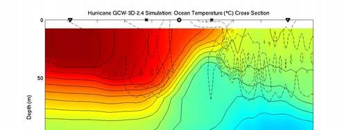
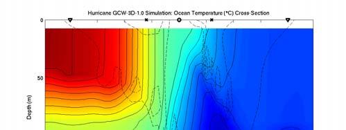
9 3D vs. 1D Ocean Coupling Some recent studies (Emanuel et al. 2004; Lin et al. 2005, 2008; Bender et al. 2007; Davis et al. 2008) suggest that coupling a 1D ocean model to a TC model may be sufficient for capturing the storm-induced SST cooling in the region providing heat energy to the TC. If a 1D model is sufficient, valuable computational resources can be saved as compared to coupled models that employ a fully three-dimensional (3D) ocean component.
10 Prescribed translation speed Hurricane vortex A T M O S P H E R E Homogeneous initial SST Vary position of ring relative to storm track O C E A N Warm core ring evident in subsurface temperature field C0 N0 R2 L2
11 Difference in SST Response Underneath the TC Core Using a 1D and a 3D Version of the Same Ocean Model Hurricanes have historically translated at < 5 m s -1 73% and < 2 m s -1 16% of the time in the Gulf of Mexico at < 5 m s -1 62% and < 2 m s -1 12% of the time in the entire western tropical North Atlantic
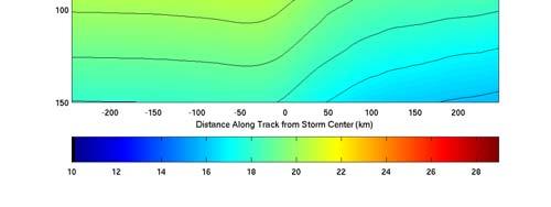
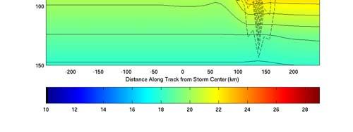
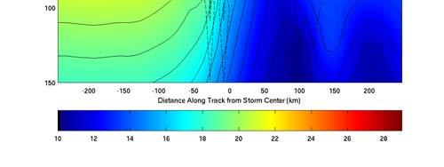
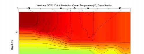
12 3 D Along-track temperature cross-sections sections 1 D 1.0 m s m s m s 1


13 SST and currents 6 hrs after storm passes WCR center longitude: 3-D experiments C0 N0 WCR Storm Storm Speed = 2.4 m s 1 L2 R2 WCR Storm WCR Storm

14 SST and currents 6 hrs after storm passes WCR center longitude: 1-D experiments C0 N0 WCR Storm Storm Speed = 2.4 m s 1 L2 R2 WCR Storm WCR Storm


15 SST cooling within 60-km radius of storm center 3-D 1-D R2 N0 N0 > R2 Mean ΔSST Speed = 2.4 m s 1 > Mean ΔSST 3-D WCR 1-D WCR < < Storm R2 SST N0 SST at +6 hours Storm R2 SST N0 SST at +6 hours
16 Conventional coupling between TC models and ocean models Wind speed (U a ) Temperature (T a ) Humidity (q a ) (at 10 m height) Tropical Cyclone Model Momentum flux (τ) Sensible heat flux (Q H ) Latent heat flux (Q E ) Air-Sea Interface Surface current (U s ) SST (T s ) (stability correction omitted for simplicity) Q Q H E τ = ρ = C L = C H V P acd( U a U s ) ( U U )( T T ) C E a s Ocean Model a ( U U )( q q ) a s a s s CD C H C E Momentum flux (τ) (Kinetic energy flux) Drag Coefficient Heat Transfer Coefficient Humidity Transfer Coeff. (Dalton Number)
 Observations of exchange coefficients C / C E D Black stars: CBLAST")
17 (CBLAST) C E C D Black et al. (2007) Observations of exchange coefficients C / C E D Black stars: CBLAST data Black dash: HEXOS data Green: COARE 3.0 (Bulk)


 Hs")
18 Waves Generated by Tropical Cyclones WAVEWATCH III wave model calculations Wind Field (m/s) 0m/s TSP = 5m/s 0m/s10m/s TSP = 5m/s 10m/s Wave Field TSP 0m/s TSP 5m/s Hs (m) Hs (m) TSP 10m/s Hs (m)
19 Coupled Wind-Wave Wave Model Near the peak : WAVEWATCH III (WW3) model. High frequency part : Equilibrium Spectrum model of Hara and Belcher (JFM, 2002) Near peak High frequency part Full wave spectrum k min k 3 k 2 k 1 k 0 k max Δk 2 Δk 1 Δk max k v Wave Boundary Layer model of Hara and Belcher (JPO, 2004) Kukulka and Hara (JPO, 2008) Explicitly calculates wave-induced stress Wind profile and drag coefficient over any given seas
20 Sea state dependence 5 4 Constant z ch (0.0185) Calculations are based on observed hurricane winds in the Atlantic basin. At high wind speeds, C d levels off and even decrease with wind speed CD * Extrapolation of Large & Pond (1981) s formula Upper and lower bounds of C d from all earlier exp. 1 GPS sonde observation under various hurricanes (Powell et al., 2003). 0 Powell et al. (2003) Large & Pond (1981) WW3 (upper and lower bound) Bulk, Our results (upper and lower bound) U10 (m/s)
21 Charnock Coefficient vs. Wind Speed and Input Wave Age Red indicates the range of realizable input wave age for given wind speed Input wave age is one of the output parameters of WW3 and is a measure m of the development stage of locally wind forced waves, excluding the effects of long swell and waves that are misaligned with the local wind

22 Sea State Dependence in Coupled TC-Wave Model Zo Cd m m/s m/s Input Wave age m/s
23 Wind-Wave Wave-Current Interaction Wind Sea state Surface waves r r τ air τ c τ r c τ r air Current Current τ r air Ocean currents Atmosphere Ocean
 Wave growth ( EF growth, ) τ r growth Ocean Currents c")
24 Energy and Momentum Flux Budget Across Air-sea Interface EF air = EF c + (EF growth + EF divergence ) r τ air r = τ c c + c r ( τ + τ ) growth r divergence Horizontal wave propagation r (EF divergence, τ divergence) Wave growth ( EF growth, ) τ r growth Ocean Currents c c

25 Wind-wave wave-current interaction Ocean response τ air Currents W at 90 m

26 Wind-wave wave-current interaction Differences in Momentum Flux τ c in A / τ air in Control τ air in B / τ air in Control Exp A Exp B Budget No current wind No current wave No budget Current wind Current wave Exp C τ air in C / τ air in Control τ c in D / τ air in Control Exp D No budget Current wind No current wave Budget Current wind Current wave
27 Effect of Wind-Wave Wave-Current Interaction on Drag Coefficient Wind-wave coupling only Wind-wave wave-current coupling Cd Cd
28 Effect of Atmosphere-Wave Wave-Ocean Interaction on TC forecasts (Idealized experiments) Central Pressure Maximum Winds Track
29 Air-Sea Coupling Strategies for Tropical Models In the TC model,, parameterizations of the air- sea heat and momentum fluxes and sea spray source functions explicitly include SST, sea state dependence,, and ocean current effects. The wave model is forced by a) sea-state state dependent momentum flux and includes ocean current effects. The ocean model is forced by sea-state dependent momentum and kinetic energy fluxes calculated from the air-sea flux budget.
30 Summary Accurate initialization of ocean mesoscale features is critical for skillful coupled TC-Ocean forecasts. By neglecting upwelling 1D mixed layer models are inadequate for TCs translating at 5 m/s or less and misrepresent TC-induced SST cooling in the vicinity of oceanic fronts and eddies. Improved predictions of TC intensity, structure, and motion will require fully coupled ocean-waveatmospheric models that explicitly resolve the effects of sea state on air-sea fluxes and spray generation.
HWRF Ocean: MPIPOM-TC
 HWRF v3.7a Tutorial Nanjing, China, December 2, 2015 HWRF Ocean: MPIPOM-TC Ligia Bernardet NOAA SRL Global Systems Division, Boulder CO University of Colorado CIRS, Boulder CO Acknowledgement Richard Yablonsky
HWRF Ocean: The Princeton Ocean Model. HWRF Tutorial NCWCP, College Park, MD January 2018
 HWRF Ocean: The Princeton Ocean Model Isaac Ginis Graduate School of Oceanography University of Rhode Island HWRF Tutorial NCWCP, College Park, MD 23-25 January 2018 1 1 Why Couple a 3-D Ocean Model to
Importance of air-sea interaction on the coupled typhoon-wave-ocean modeling
 Importance of air-sea interaction on the coupled typhoon-wave-ocean modeling Collaborators: I. Ginis (GSO/URI) T. Hara (GSO/URI) B. Thomas (GSO/URI) H. Tolman (NCEP/NOAA) IL-JU MOON ( 文一柱 ) Cheju National
Momentum Flux Budget Across Air-sea Interface under Uniform and Tropical Cyclone Winds
 Momentum Flux Budget Across Air-sea Interface under Uniform and Tropical Cyclone Winds Yalin Fan 1, Isaac Ginis 2, Tetsu Hara 2 1. AOS, Princeton University / GFDL, NOAA, Princeton, New Jersey 2. Graduate
Richard M. Yablonsky University of Rhode Island. WRF for Hurricanes Tutorial Boulder, CO 25 February 2010
 Richard M. Yablonsky University of Rhode Island WRF for Hurricanes Tutorial Boulder, CO 25 February 2010 1 What is the Princeton Ocean Model? Three dimensional, primitive equation, numerical ocean model
12A.2 NUMERICAL SIMULATIONS OF THE HURRICANE INTENSITY RESPONSE TO A WARM OCEAN EDDY
 12A.2 NUMERICAL SIMULATIONS OF THE HURRICANE INTENSITY RESPONSE TO A WARM OCEAN EDDY Richard M. Yablonsky* and Isaac Ginis University of Rhode Island, Narragansett, Rhode Island 1. INTRODUCTION Hurricanes
Momentum Flux Budget across the Air Sea Interface under Uniform and Tropical Cyclone Winds
 OCTOBER 2010 F A N E T A L. 2221 Momentum Flux Budget across the Air Sea Interface under Uniform and Tropical Cyclone Winds YALIN FAN Atmospheric and Oceanic Sciences Program, Princeton University, and
Improving Air-Sea Coupling Parameterizations in High-Wind Regimes
 Improving Air-Sea Coupling Parameterizations in High-Wind Regimes PI: Dr. Shuyi S. Chen Co-PI: Dr. Mark A. Donelan Rosenstiel School of Marine and Atmospheric Science, University of Miami 4600 Rickenbacker
18A.2 PREDICTION OF ATLANTIC TROPICAL CYCLONES WITH THE ADVANCED HURRICANE WRF (AHW) MODEL
 MODEL") 18A.2 PREDICTION OF ATLANTIC TROPICAL CYCLONES WITH THE ADVANCED HURRICANE WRF (AHW) MODEL Jimy Dudhia *, James Done, Wei Wang, Yongsheng Chen, Qingnong Xiao, Christopher Davis, Greg Holland, Richard Rotunno,
18A.2 PREDICTION OF ATLANTIC TROPICAL CYCLONES WITH THE ADVANCED HURRICANE WRF (AHW) MODEL Jimy Dudhia *, James Done, Wei Wang, Yongsheng Chen, Qingnong Xiao, Christopher Davis, Greg Holland, Richard Rotunno,
The Effect of Sea Spray on Tropical Cyclone Intensity
 The Effect of Sea Spray on Tropical Cyclone Intensity Jeffrey S. Gall, Young Kwon, and William Frank The Pennsylvania State University University Park, Pennsylvania 16802 1. Introduction Under high-wind
Numerical Simulations and Observations of Surface Wave Fields under an Extreme Tropical Cyclone
 SEPTEMBER 2009 F A N E T A L. 2097 Numerical Simulations and Observations of Surface Wave Fields under an Extreme Tropical Cyclone YALIN FAN, ISAAC GINIS, AND TETSU HARA Graduate School of Oceanography,
6C.4 USING AXBTS TO IMPROVE THE PERFORMANCE OF COUPLED HURRICANE-OCEAN MODELS
 6C.4 USING AXBTS TO IMPROVE THE PERFORMANCE OF COUPLED HURRICANE-OCEAN MODELS Richard M. Yablonsky* and Isaac Ginis Graduate School of Oceanography, University of Rhode Island, Narragansett, Rhode Island
Limitation of One-Dimensional Ocean Models for Coupled Hurricane Ocean Model Forecasts
 4410 M O N T H L Y W E A T H E R R E V I E W VOLUME 137 Limitation of One-Dimensional Ocean Models for Coupled Hurricane Ocean Model Forecasts RICHARD M. YABLONSKY AND ISAAC GINIS Graduate School of Oceanography,
Objectives for meeting
 Objectives for meeting 1) Summarize planned experiments 2) Discuss resource availability Aircraft Instrumentation Expendables 3) Assign working groups to complete each experiment plan Flight planning and
6A.4 IMPACT OF A WARM OCEAN EDDY S CIRCULATION ON HURRICANE-INDUCED SEA SURFACE COOLING WITH IMPLICATIONS FOR HURRICANE INTENSITY
 6A.4 IMPACT OF A WARM OCEAN EDDY S CIRCULATION ON HURRICANE-INDUCED SEA SURFACE COOLING WITH IMPLICATIONS FOR HURRICANE INTENSITY Richard M. Yablonsky* and Isaac Ginis University of Rhode Island, Narragansett,
Air-Sea Interaction: Physics of air-surface interactions and coupling to ocean/atmosphere BL processes
 Air-Sea Interaction: Physics of air-surface interactions and coupling to ocean/atmosphere BL processes Emphasize surface fluxes Statement of problem Present status Parameterization issues An amusing case
Impact of the Waves on the Sea Surface Roughness Length under Idealized Like-Hurricane Wind Conditions (Part II)
") Atmospheric and Climate Sciences, 2015, 5, 326-335 Published Online July 2015 in SciRes. http://www.scirp.org/journal/acs http://dx.doi.org/10.4236/acs.2015.53025 Impact of the Waves on the Sea Surface
Atmospheric and Climate Sciences, 2015, 5, 326-335 Published Online July 2015 in SciRes. http://www.scirp.org/journal/acs http://dx.doi.org/10.4236/acs.2015.53025 Impact of the Waves on the Sea Surface
Coupled Ocean-Wave Model Team (Team 8) Report
 Report") Coupled Ocean-Wave Model Team (Team 8) Report George Halliwell (co-lead, NOAA/AOML/PhOD) Hendrik Tolman (co-lead, NOAA/NCEP) Isaac Ginis (URI) Chris Fairall (NOAA/ESRL) Shaowu Bao (NOAA/ESRL) Jian-Wen
Coupled Ocean-Wave Model Team (Team 8) Report George Halliwell (co-lead, NOAA/AOML/PhOD) Hendrik Tolman (co-lead, NOAA/NCEP) Isaac Ginis (URI) Chris Fairall (NOAA/ESRL) Shaowu Bao (NOAA/ESRL) Jian-Wen
Improving Surface Flux Parameterizations in the NRL Coupled Ocean/Atmosphere Mesoscale Prediction System
 Improving Surface Flux Parameterizations in the NRL Coupled Ocean/Atmosphere Mesoscale Prediction System LONG-TERM GOAL Shouping Wang Naval Research Laboratory Monterey, CA 93943 Phone: (831) 656-4719
Impact of a Warm Ocean Eddy s Circulation on Hurricane-Induced Sea Surface Cooling with Implications for Hurricane Intensity. Richard M.
 Impact of a Warm Ocean Eddy s Circulation on Hurricane-Induced Sea Surface Cooling with Implications for Hurricane Intensity Richard M. Yablonsky Isaac Ginis Graduate School of Oceanography University
Air-Sea Interaction in Extreme Weather Conditions
 Air-Sea Interaction in Extreme Weather Conditions Hans (J.W.) de Vries, Niels Zweers,, Vladimir Makin, Vladimir Kudryavtsev, and Gerrit Burgers, KNMI, De Bilt, NL Meteogroup, Wageningen, NL NIERSC, St.
HWRF Surface Layer Thermodynamics Evaluation. Eric W. Uhlhorn and Joseph J. Cione HFIP Hurricane Modeling Workshop September 2012
 HWRF Surface Layer Thermodynamics Evaluation Eric W. Uhlhorn and Joseph J. Cione HFIP Hurricane Modeling Workshop 17-18 September 2012 Special thanks. HRD HWRF modeling team Gopal, Xuejin Zhang, Thiago
The CBLAST-Hurricane Program and the Next-Generation Fully Coupled Atmosphere- Wave-Ocean Models for Hurricane Research and Prediction
 The CBLAST-Hurricane Program and the Next-Generation Fully Coupled Atmosphere- Wave-Ocean Models for Hurricane Research and Prediction Shuyi S. Chen 1*, James F. Price 2, Wei Zhao 1, Mark A. Donelan 1,
Thermodynamic and Flux Observations of the Tropical Cyclone Surface Layer
 Thermodynamic and Flux Observations of the Tropical Cyclone Surface Layer 1. INTRODUCTION Alex M. Kowaleski and Jenni L. Evans 1 The Pennsylvania State University, University Park, PA Understanding tropical
Impact of sea surface temperature on COSMO forecasts of a Medicane over the western Mediterranean Sea
 Impact of sea surface temperature on COSMO forecasts of a Medicane over the western Mediterranean Sea V. Romaniello (1), P. Oddo (1), M. Tonani (1), L. Torrisi (2) and N. Pinardi (3) (1) National Institute
HFIP Coupling Working Group
 HFIP Coupling Working Group Progress report with contributions of Tolman (NCEP), Chen (NRL), Ginis (URI) Hendrik L. Tolman Chief, Marine Modeling and Analysis Branch NOAA / NWS / NCEP / EMC Hendrik.Tolman@NOAA.gov
Large-Eddy Simulations of Tropical Convective Systems, the Boundary Layer, and Upper Ocean Coupling
 DISTRIBUTION STATEMENT A. Approved for public release; distribution is unlimited. Large-Eddy Simulations of Tropical Convective Systems, the Boundary Layer, and Upper Ocean Coupling Eric D. Skyllingstad
Variations of total heat flux during typhoons in the South China Sea
 78 Variations of total heat flux during typhoons in the South China Sea Wan Ruslan Ismail 1, and Tahereh Haghroosta 2,* 1 Section of Geography, School of Humanities, Universiti Sains Malaysia, 11800 Minden,
Related Improvements. A DFS Application. Mark A. Bourassa
 Related Improvements in Surface Turbulent Heat Fluxes A DFS Application Center for Ocean-Atmospheric Prediction Studies & Department of Earth, Ocean and Atmospheric Sciences, The Florida State University,
Numerical Weather Prediction: Data assimilation. Steven Cavallo
 Numerical Weather Prediction: Data assimilation Steven Cavallo Data assimilation (DA) is the process estimating the true state of a system given observations of the system and a background estimate. Observations
Advanced Hurricane WRF (AHW) Physics
 Physics") Advanced Hurricane WRF (AHW) Physics Jimy Dudhia MMM Division, NCAR 1D Ocean Mixed-Layer Model 1d model based on Pollard, Rhines and Thompson (1973) was added for hurricane forecasts Purpose is to represent
Advanced Hurricane WRF (AHW) Physics Jimy Dudhia MMM Division, NCAR 1D Ocean Mixed-Layer Model 1d model based on Pollard, Rhines and Thompson (1973) was added for hurricane forecasts Purpose is to represent
Tropical cyclone simulations and predictions with GFDL s prototype global cloud resolving model
 Tropical cyclone simulations and predictions with GFDL s prototype global cloud resolving model S.-J. Lin and GFDL model development teams NOAA/Geophysical Fluid Dynamics Laboratory Workshop on High-Resolution
Early Student Support for a Process Study of Oceanic Responses to Typhoons
 DISTRIBUTION STATEMENT A. Approved for public release; distribution is unlimited. Early Student Support for a Process Study of Oceanic Responses to Typhoons Ren-Chieh Lien Applied Physics Laboratory University
Study on Air-Sea Interaction under Typhoon and Its Application of Two Important Projects
 ESCAP/WMO Typhoon Committee Technical Conference (TC50 TECO) Study on Air-Sea Interaction under Typhoon and Its Application of Two Important Projects Li Yongping Shanghai Typhoon Institute/CMA 2018.02.26
The Operational GFDL Coupled Hurricane Ocean Prediction System and a Summary of Its Performance
 DECEMBER 2007 BENDER ET AL. 3965 The Operational GFDL Coupled Hurricane Ocean Prediction System and a Summary of Its Performance MORRIS A. BENDER NOAA/GFDL, Princeton, New Jersey ISAAC GINIS Graduate School
New findings on hurricane intensity, wind field extent, and surface drag coefficient behavior
 New findings on hurricane intensity, wind field extent, and surface drag coefficient behavior Mark D. Powell NOAA Atlantic Oceanographic and Meteorological Laboratories Hurricane Research Division Miami
2.1 OBSERVATIONS AND THE PARAMETERISATION OF AIR-SEA FLUXES DURING DIAMET
 2.1 OBSERVATIONS AND THE PARAMETERISATION OF AIR-SEA FLUXES DURING DIAMET Peter A. Cook * and Ian A. Renfrew School of Environmental Sciences, University of East Anglia, Norwich, UK 1. INTRODUCTION 1.1
Annual Number of Peer Reviewed Articles with Hurricane or Tropical Cyclone in their Titles, according to Meteorological and Geoastrophysical
 Hurricanes and Climate Kerry Emanuel Program in Atmospheres, Oceans, and Climate MIT Program Potential Intensity Role of potential ti li intensity it in storm intensity it Role of potential intensity in
IWTC-VIII: Section 4.4 Oceanic Influences and Air-Sea Interactions In Tropical Cyclones
 IWTC-VIII: Section 4.4 Oceanic Influences and Air-Sea Interactions In Tropical Cyclones Lynn K. Nick Shay Panel Members: M. M. Ali, S. Chen, I. Ginis, G. Halliwell, H-S Kim, Marie-Dominque Leroux, I-I
COUPLED TROPICAL CYCLONE-OCEAN MODELING FOR CAPABILITIES. Graduate School of Oceanography. Phone: Fax:
 COUPLED TROPICAL CYCLONE-OCEAN MODELING FOR TRANSITION TO OPERATIONAL PREDICTIVE CAPABILITIES Isaac Ginis and Lewis M. Rothstein Graduate School of Oceanography University of Rhode Island, Narragansett,
New Observations of Ocean Response to a Hurricane
 New Observations of Ocean Response to a Hurricane Thomas B. Sanford and James B. Girton Applied Physics Laboratory and School of Oceanography University of Washington In collaboration with: Eric A. D Asaro
Earth Observatory, Columbia University
 Satellite-Based Mid dlatitude Cyclone Statistics Over the Southern Ocean -- Tracks and Su urface Fluxes Xiaojun Yuan August 19, 2009 In collaboration with Jérôme Pato oux at University of Washington and
COAMPS-TC 2015 Version, Performance, and Future Plans
 COAMPS-TC 2015 Version, Performance, and Future Plans James D. Doyle, R. Hodur 1, J. Moskaitis, S. Chen, E. Hendricks 2, H. Jin, Y. Jin, A. Reinecke, S. Wang Naval Research Laboratory, Monterey, CA 1 IES/SAIC,
John Steffen and Mark A. Bourassa
 John Steffen and Mark A. Bourassa Funding by NASA Climate Data Records and NASA Ocean Vector Winds Science Team Florida State University Changes in surface winds due to SST gradients are poorly modeled
The record-setting 2005 hurricane season has
 The CBLAST-Hurricane Program and the Next- Generation Fully Coupled Atmosphere Wave Ocean Models for Hurricane Research and Prediction BY SHUYI S. CHEN, JAMES F. PRICE, WEI ZHAO, MARK A. DONELAN, AND EDWARD
Exploring the Use of Dynamical Weather and Climate Models for Risk Assessment
 Exploring the Use of Dynamical Weather and Climate Models for Risk Assessment James Done Willis Research Network Fellow National Center for Atmospheric Research Boulder CO, US Leverages resources in the
Evolution of the GFDL hurricane model in research and transition to NMC operations
 Evolution of the GFDL hurricane model in research and transition to NMC operations Robert E. Tuleya (Saic, EMC & CCPO/ODU) Morris Bender (GFDL) Isaac Ginis (URI) Tim Marchok (GFDL) URI/GSO Y. Kurihara
Motivation & Goal. We investigate a way to generate PDFs from a single deterministic run
 Motivation & Goal Numerical weather prediction is limited by errors in initial conditions, model imperfections, and nonlinearity. Ensembles of an NWP model provide forecast probability density functions
Lectures on Tropical Cyclones
 Lectures on Tropical Cyclones Chapter 1 Observations of Tropical Cyclones Outline of course Introduction, Observed Structure Dynamics of Mature Tropical Cyclones Equations of motion Primary circulation
The Impact of Sea Spray on Air-Sea Fluxes in Coupled Atmosphere-Ocean Models
 The Impact of Sea Spray on Air-Sea Fluxes in Coupled Atmosphere-Ocean Models Edgar L Andreas U. S. Army Cold Regions Research and Engineering Laboratory 72 Lyme Road Hanover, New Hampshire 03755-1290 phone:
Post Processing of Hurricane Model Forecasts
 Post Processing of Hurricane Model Forecasts T. N. Krishnamurti Florida State University Tallahassee, FL Collaborators: Anu Simon, Mrinal Biswas, Andrew Martin, Christopher Davis, Aarolyn Hayes, Naomi
A New Ocean Mixed-Layer Model Coupled into WRF
 ATMOSPHERIC AND OCEANIC SCIENCE LETTERS, 2012, VOL. 5, NO. 3, 170 175 A New Ocean Mixed-Layer Model Coupled into WRF WANG Zi-Qian 1,2 and DUAN An-Min 1 1 The State Key Laboratory of Numerical Modeling
Impact of a Warm Ocean Eddy s Circulation on Hurricane-Induced Sea Surface Cooling with Implications for Hurricane Intensity
 MARCH 2013 Y A B L O N S K Y A N D G I N I S 997 Impact of a Warm Ocean Eddy s Circulation on Hurricane-Induced Sea Surface Cooling with Implications for Hurricane Intensity RICHARD M. YABLONSKY AND ISAAC
Early Student Support for a Process Study of Oceanic Responses to Typhoons
 DISTRIBUTION STATEMENT A. Approved for public release; distribution is unlimited. Early Student Support for a Process Study of Oceanic Responses to Typhoons Ren-Chieh Lien Applied Physics Laboratory University
非静力学 4 次元変分法. Kosuke Ito
 The 3 rd Research Meeting of Ultrahigh Precision Meso Scale Weather Prediction Kobe, Japan 2013/03/21 / 非静力学 4 次元変分法 データ同化システムの高度化 Development of nonhydrostatic meso 4D VAR dt data assimilation il system
Effect of Typhoon-Driven Ocean Waves on Sea-to-Air Transfer of Dimethylsulfide (DMS)
") Effect of Typhoon-Driven Ocean Waves on Sea-to-Air Transfer of Dimethylsulfide (DMS) Peter C Chu Department of Oceanography Naval Postgraduate School Monterey, California, USA pcchu@nps.edu http://www.oc.nps.navy.mil/~chu
Effect of Typhoon-Driven Ocean Waves on Sea-to-Air Transfer of Dimethylsulfide (DMS) Peter C Chu Department of Oceanography Naval Postgraduate School Monterey, California, USA pcchu@nps.edu http://www.oc.nps.navy.mil/~chu
A Reformulation of the Logistic Growth Equation Model (LGEM) for Ensemble and Extended Range Intensity Prediction
 for Ensemble and Extended Range Intensity Prediction") A Reformulation of the Logistic Growth Equation Model (LGEM) for Ensemble and Extended Range Intensity Prediction Mark DeMaria NOAA/NESDIS, Fort Collins, CO Andrea Schumacher and Kate Musgrave CIRA/CSU,
A Reformulation of the Logistic Growth Equation Model (LGEM) for Ensemble and Extended Range Intensity Prediction Mark DeMaria NOAA/NESDIS, Fort Collins, CO Andrea Schumacher and Kate Musgrave CIRA/CSU,
A Preliminary Exploration of the Upper Bound of Tropical Cyclone Intensification
 A Preliminary Exploration of the Upper Bound of Tropical Cyclone Intensification Jonathan L. Vigh (NCAR/RAL) Kerry Emanuel (MIT) Mrinal K. Biswas (NCAR/RAL) Eric A. Hendricks (Naval Postgraduate School)
Cold wake of Hurricane Frances
 Click Here for Full Article GEOPHYSICAL RESEARCH LETTERS, VOL. 34, L15609, doi:10.1029/2007gl030160, 2007 Cold wake of Hurricane Frances Eric A. D Asaro, 1 Thomas B. Sanford, 1 P. Peter Niiler, 2 and Eric
Tropical Cyclone Formation/Structure/Motion Studies
 Tropical Cyclone Formation/Structure/Motion Studies Patrick A. Harr Department of Meteorology Naval Postgraduate School Monterey, CA 93943-5114 phone: (831) 656-3787 fax: (831) 656-3061 email: paharr@nps.edu
Have a better understanding of the Tropical Cyclone Products generated at ECMWF
 Objectives Have a better understanding of the Tropical Cyclone Products generated at ECMWF Learn about the recent developments in the forecast system and its impact on the Tropical Cyclone forecast Learn
Improved Fields of Satellite-Derived Ocean Surface Turbulent Fluxes of Energy and Moisture
 Improved Fields of Satellite-Derived Ocean Surface Turbulent Fluxes of Energy and Moisture First year report on NASA grant NNX09AJ49G PI: Mark A. Bourassa Co-Is: Carol Anne Clayson, Shawn Smith, and Gary
Recent Developments at NOAA/GFDL
 Recent Developments at NOAA/GFDL WGNE-2012, Toulouse FRANCE V. Balaji balaji@princeton.edu NOAA/GFDL and Princeton University 8 November 2012 Balaji (Princeton and GFDL) Developments at GFDL 8 November
Energy transport and transfer in the wake of a tropical cyclone
 Energy transport and transfer in the wake of a tropical cyclone Claudia Pasquero Department of Earth and Environmental Sciences Università degli Studi di Milano - Bicocca Agostino Meroni, Francesco Ragone
Numerical simulations of tropical cyclone ocean interaction with a high resolution coupled model
 University of Rhode Island DigitalCommons@URI Graduate School of Oceanography Faculty Publications Graduate School of Oceanography 1993 Numerical simulations of tropical cyclone ocean interaction with
Hurricane Intensity: Governing Factors and Forecasting Challenges. EAS 470 Final Paper Allison Wing
 Hurricane Intensity: Governing Factors and Forecasting Challenges EAS 470 Final Paper Allison Wing Tropical cyclones are undoubtedly among the mostly deadly and destructive natural phenomena found on Earth
Tropical Cyclone-Ocean Interactions
 Tropical Cyclone-Ocean Interactions Isaac Ginis Graduate School of Oceanography, University of Rhode Island Narragansett, RI 02882 USA Abstract The advent of numerical weather prediction tropical cyclone
WAVE-ATMOSPHERE-OCEAN MODELLING OF RECENT STORMS
 WAVE-ATMOSPHERE-OCEAN MODEING OF RECENT STORMS W.Perrie 1, W. Zhang 1,4, Z. ong 1,2, W. i 1,3 & B. Toulany 1 1 Bedford Institute of Oceanography, Dartmouth, Nova Scotia, Canada 2 Institute for Atmospheric
Impact of Typhoons on the Western Pacific Ocean DRI: Numerical Modeling of Ocean Mixed Layer Turbulence and Entrainment at High Winds
 Impact of Typhoons on the Western Pacific Ocean DRI: Numerical Modeling of Ocean Mixed Layer Turbulence and Entrainment at High Winds Ramsey R. Harcourt Applied Physics Laboratory, University of Washington,
Mesoscale meteorological models. Claire L. Vincent, Caroline Draxl and Joakim R. Nielsen
 Mesoscale meteorological models Claire L. Vincent, Caroline Draxl and Joakim R. Nielsen Outline Mesoscale and synoptic scale meteorology Meteorological models Dynamics Parametrizations and interactions
Figure 2. Time series of the standard deviation of spatial high pass filtered QuikSCAT wind stress (solid) and AMSR SST (dashed) for (top to bottom)
 and AMSR SST (dashed) for (top to bottom)") a) Figure 1. Spatial high pass filtered a) QuikSCAT wind stress (colors) and AMSR SST (contours), QuikSCAT wind stress divergence (colors) and AMSR downwind SST gradient (contours) and QuikSCAT wind stress
a) Figure 1. Spatial high pass filtered a) QuikSCAT wind stress (colors) and AMSR SST (contours), QuikSCAT wind stress divergence (colors) and AMSR downwind SST gradient (contours) and QuikSCAT wind stress
Midlatitude storm impacts on air sea CO 2 fluxes
 CHAPTER 6 Midlatitude storm impacts on air sea CO 2 fluxes W. Perrie 1,2, W. Zhang 1,2,X.Ren 3, Z. Long 1,2 & J. Hare 4 1 Fisheries & Oceans Canada, Bedford Institute of Oceanography, Dartmouth, Canada.
Tropical Cyclone Atmospheric Forcing 1 for Ocean Response Models: Approaches and Issues
 Tropical Cyclone Atmospheric Forcing 1 for Ocean Response Models: Approaches and Issues Vincent Cardone and Andrew Cox Oceanweather Inc. Cos Cob, CT, USA DEFINITION: 1 Specification of time and space evolution
Lecture 1. Amplitude of the seasonal cycle in temperature
 Lecture 6 Lecture 1 Ocean circulation Forcing and large-scale features Amplitude of the seasonal cycle in temperature 1 Atmosphere and ocean heat transport Trenberth and Caron (2001) False-colour satellite
NOTES AND CORRESPONDENCE. The Effects of Dissipative Heating on Hurricane Intensity
 3032 MONTHLY WEATHER REVIEW NOTES AND CORRESPONDENCE The Effects of Dissipative Heating on Hurricane Intensity DA-LIN ZHANG AND ERIC ALTSHULER Department of Meteorology, University of Maryland, College
2013 ATLANTIC HURRICANE SEASON OUTLOOK. June RMS Cat Response
 2013 ATLANTIC HURRICANE SEASON OUTLOOK June 2013 - RMS Cat Response Season Outlook At the start of the 2013 Atlantic hurricane season, which officially runs from June 1 to November 30, seasonal forecasts
PRMS WHITE PAPER 2014 NORTH ATLANTIC HURRICANE SEASON OUTLOOK. June RMS Event Response
 PRMS WHITE PAPER 2014 NORTH ATLANTIC HURRICANE SEASON OUTLOOK June 2014 - RMS Event Response 2014 SEASON OUTLOOK The 2013 North Atlantic hurricane season saw the fewest hurricanes in the Atlantic Basin
Surface Wind/Stress Structure under Hurricane
 Surface Wind/Stress Structure under Hurricane W. Timothy Liu and Wenqing Tang, JPL Asymmetry Relating wind to stress 2008 NASA Ocean Vector Wind Science Team Meeting, 19-21 November 2008, Seattle, WA Asymmetry
Extratropical transition of North Atlantic tropical cyclones in variable-resolution CAM5
 Extratropical transition of North Atlantic tropical cyclones in variable-resolution CAM5 Diana Thatcher, Christiane Jablonowski University of Michigan Colin Zarzycki National Center for Atmospheric Research
IMPACT OF GROUND-BASED GPS PRECIPITABLE WATER VAPOR AND COSMIC GPS REFRACTIVITY PROFILE ON HURRICANE DEAN FORECAST. (a) (b) (c)
 (b) (c)") 9B.3 IMPACT OF GROUND-BASED GPS PRECIPITABLE WATER VAPOR AND COSMIC GPS REFRACTIVITY PROFILE ON HURRICANE DEAN FORECAST Tetsuya Iwabuchi *, J. J. Braun, and T. Van Hove UCAR, Boulder, Colorado 1. INTRODUCTION
9B.3 IMPACT OF GROUND-BASED GPS PRECIPITABLE WATER VAPOR AND COSMIC GPS REFRACTIVITY PROFILE ON HURRICANE DEAN FORECAST Tetsuya Iwabuchi *, J. J. Braun, and T. Van Hove UCAR, Boulder, Colorado 1. INTRODUCTION
Hurricanes are intense vortical (rotational) storms that develop over the tropical oceans in regions of very warm surface water.
 storms that develop over the tropical oceans in regions of very warm surface water.") Hurricanes: Observations and Dynamics Houze Section 10.1. Holton Section 9.7. Emanuel, K. A., 1988: Toward a general theory of hurricanes. American Scientist, 76, 371-379 (web link). http://ww2010.atmos.uiuc.edu/(gh)/guides/mtr/hurr/home.rxml
Hurricanes: Observations and Dynamics Houze Section 10.1. Holton Section 9.7. Emanuel, K. A., 1988: Toward a general theory of hurricanes. American Scientist, 76, 371-379 (web link). http://ww2010.atmos.uiuc.edu/(gh)/guides/mtr/hurr/home.rxml
NWS Operational Marine and Ocean Forecasting. Overview. Ming Ji. Ocean Prediction Center National Weather Service/NCEP. CIOSS/CoRP
 NWS Operational Marine and Ocean Forecasting Overview Ming Ji Ocean Prediction Center National Weather Service/NCEP CIOSS/CoRP CoRP Symposium Corvallis, OR Aug. 12-13, 13, 2008 Titanic Telegram Marine
CHAPTER 8 NUMERICAL SIMULATIONS OF THE ITCZ OVER THE INDIAN OCEAN AND INDONESIA DURING A NORMAL YEAR AND DURING AN ENSO YEAR
 CHAPTER 8 NUMERICAL SIMULATIONS OF THE ITCZ OVER THE INDIAN OCEAN AND INDONESIA DURING A NORMAL YEAR AND DURING AN ENSO YEAR In this chapter, comparisons between the model-produced and analyzed streamlines,
1. Introduction. In following sections, a more detailed description of the methodology is provided, along with an overview of initial results.
 7B.2 MODEL SIMULATED CHANGES IN TC INTENSITY DUE TO GLOBAL WARMING Kevin A. Hill*, Gary M. Lackmann, and A. Aiyyer North Carolina State University, Raleigh, North Carolina 1. Introduction The impact of
Coupled Ocean-Atmosphere Modeling of the Coastal Zone
 Coupled Ocean-Atmosphere Modeling of the Coastal Zone Eric D. Skyllingstad College of Oceanic and Atmospheric Sciences, Oregon State University 14 Ocean Admin. Bldg., Corvallis, OR 97331 Phone: (541) 737-5697
Tropical Cyclone Genesis: What we know, and what we don t!
 Tropical Cyclone Genesis: What we know, and what we don t! Allison Wing! NSF Postdoctoral Research Fellow! Lamont-Doherty Earth Observatory! Columbia University! Overview! Climatology! What We Know! Theories!
Fernando Prates. Evaluation Section. Slide 1
 Fernando Prates Evaluation Section Slide 1 Objectives Ø Have a better understanding of the Tropical Cyclone Products generated at ECMWF Ø Learn the recent developments in the forecast system and its impact
Super-Parameterization of Boundary Layer Roll Vortices in Tropical Cyclone Models
 DISTRIBUTION STATEMENT A. Approved for public release; distribution is unlimited. Super-Parameterization of Boundary Layer Roll Vortices in Tropical Cyclone Models PI Isaac Ginis Graduate School of Oceanography
Kevin E Trenberth NCAR
 Attribution of Recent Increases in Atlantic Hurricane Activity Kevin E Trenberth NCAR Issues for detection and attribution of changes in hurricanes What has happened? How good is the observational record?
The Impact of Sea Spray on Air-Sea Fluxes in Coupled Atmosphere-Ocean Models
 The Impact of Sea Spray on Air-Sea Fluxes in Coupled Atmosphere-Ocean Models Edgar L Andreas U. S. Army Cold Regions Research and Engineering Laboratory 72 Lyme Road Hanover, New Hampshire 03755-1290 phone:
An Observational and Modeling Study of Air-Sea Fluxes at Very High Wind Speeds
 An Observational and Modeling Study of Air-Sea Fluxes at Very High Wind Speeds Kerry Emanuel Room 54-1620, MIT 77 Massachusetts Avenue Cambridge, MA 02139 phone: (617) 253-2462 fax: (425) 740-9133 email:
SUPPLEMENTARY INFORMATION
 Figure S1. Summary of the climatic responses to the Gulf Stream. On the offshore flank of the SST front (black dashed curve) of the Gulf Stream (green long arrow), surface wind convergence associated with
ARW/EnKF performance for the 2009 Hurricane Season
 ARW/EnKF performance for the 2009 Hurricane Season Ryan D. Torn, Univ. at Albany, SUNY Chris Davis, Steven Cavallo, Chris Snyder, Wei Wang, James Done, NCAR/MMM 4 th EnKF Workshop 8 April 2010, Rensselaerville,
Hurricane Science Tutorial. Kerry Emanuel Lorenz Center, MIT
 Hurricane Science Tutorial Kerry Emanuel Lorenz Center, MIT Why Should You Care? Forecasting Much progress in social science of response to warnings, requests to evacuate, etc. Forecasters are ambassadors
Chapter 24 Tropical Cyclones
 Chapter 24 Tropical Cyclones Tropical Weather Systems Tropical disturbance a cluster of thunderstorms about 250 to 600 km in diameter, originating in the tropics or sub-tropics Tropical depression a cluster
Hurricanes: Their physics and relationship to climate. Kerry Emanuel Massachusetts Institute of Technology
 Hurricanes: Their physics and relationship to climate Kerry Emanuel Massachusetts Institute of Technology Topics Overview of Tropical Cyclones Tropical Cyclone Physics What have TCs been like in the past,
Process Study of Oceanic Responses to Typhoons Using Arrays of EM-APEX Floats and Moorings
 DISTRIBUTION STATEMENT A. Approved for public release; distribution is unlimited. Process Study of Oceanic Responses to Typhoons Using Arrays of EM-APEX Floats and Moorings Ren-Chieh Lien Applied Physics
Ocean Model Impact Study Proposal for 2015
 Ocean Model Impact Study Proposal for 2015 OMITT-1 Background: HWRF w/ 3D POM-TC Yablonsky et al. (2010 IHC) confirmed POM tended to under-cool in response to prescribed wind stress based on observed TC
Kalimantan realistically (Figs. 8.23a-d). Also, the wind speeds of the westerly
. Also, the wind speeds of the westerly") suppressed rainfall rate (maximum vertical velocity) around 17 LST (Figs. 8.21a-b). These results are in agreement with previous studies (e. g., Emanuel and Raymond 1994). The diurnal variation of maximum
suppressed rainfall rate (maximum vertical velocity) around 17 LST (Figs. 8.21a-b). These results are in agreement with previous studies (e. g., Emanuel and Raymond 1994). The diurnal variation of maximum
COLORADO STATE UNIVERSITY FORECAST OF ATLANTIC HURRICANE ACTIVITY FROM SEPTEMBER 13-SEPTEMBER 26, 2018
 COLORADO STATE UNIVERSITY FORECAST OF ATLANTIC HURRICANE ACTIVITY FROM SEPTEMBER 13-SEPTEMBER 26, 2018 We expect that the next two weeks will be characterized by near-normal amounts of hurricane activity.