Post Processing of Hurricane Model Forecasts
|
|
|
- Vivien Little
- 5 years ago
- Views:
Transcription

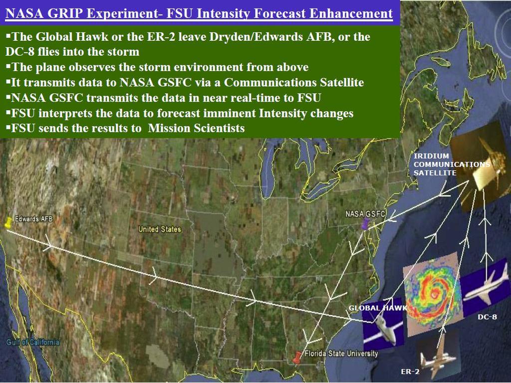
1 Post Processing of Hurricane Model Forecasts T. N. Krishnamurti Florida State University Tallahassee, FL Collaborators: Anu Simon, Mrinal Biswas, Andrew Martin, Christopher Davis, Aarolyn Hayes, Naomi Surgi, TSV Vijaya Kumar
2 ARW Model Description The real-time ARW forecasts in 2005 used a two-way nested configuration (Michalakes et al. 2005), that featured a 12-km outer fixed domain with a movable nest of 4/1.33-km grid spacing. The nest was centered on the location of the minimum 500-hPa geopotential height within a prescribed search radius from the previous position of the vortex center (or within a radius of the first guess, when first starting). Nest repositioning was calculated every 15 simulation minutes and the width of the search radius was based on the maximum distance the vortex could move at 40 m s 1. On the 12-km domain, the Kain Fritsch cumulus parameterization was used, but domains with finer resolution had no parameterization. All domains used the WRF single-moment 3-class (WSM3) microphysics scheme (Hong et al. 2004) that predicted only one cloud variable (water for T > 0 C and ice for T < 0 C) and one hydrometeor variable, either rainwater or snow (again thresholded on 0 C). Both domains also used the Yonsei University (YSU) scheme for the planetary boundary layer (Noh et al. 2003). This is a first-order closure scheme that is similar in concept to the scheme of Hong and Pan (1996), but appears less biased toward excessive vertical mixing as reported by Braun and Tao (2000). The drag formulation follows Charnock (1955) and is described more in section 5. The surface exchange coefficient for water vapor follows Carlson and Boland (1978), and the heat flux uses a similarity relationship (Skamarock et al. 2005). The forecasts were integrated from 0000 UTC and occasionally 1200 UTC during the time when a hurricane threatened landfall within 72 h. Forecasts were initialized using the Geophysical Fluid Dynamics Laboratory (GFDL) model, with data on a ⅙ latitude longitude grid. The Global Forecast Model (GFS) from the National Centers for Environmental Prediction (NCEP), obtained on a 1 grid, was used only when the GFDL was unavailable. Davis, C., W. Wang, S.S. Chen, Y. Chen, K. Corbosiero, M. DeMaria, J. Dudhia, G. Holland, J. Klemp, J. Michalakes, H. Reeves, R. Rotunno, C. Snyder, and Q. Xiao, 2008: Prediction of Landfalling Hurricanes with the Advanced Hurricane WRF Model. Mon. Wea. Rev., 136,
3 Post processing diagnostics Here we shall be showing some post processing for WRF-ARW. This model is presently being added to our suite of mesoscale models.

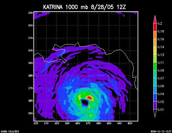
4 Predicted storm center location at indicated valid times (below) is denoted by blue star in each figure. Wind fields from AHW forecasts have been shifted to observed locations to facilitate comparison. HWind valid times are (a) 1132 UTC 29 Aug Katrina, valid time = 1200 UTC 29 Aug (60-h forecast) 10-m wind from AHW real-time forecasts with contours of nearest HWind (black lines) analyses overlaid
5 Predicted intensity and minimum sea level pressure at different forecast hours (a) Maximum 10-m wind and (b) minimum sea level pressure for forecasts of Katrina beginning 0000 UTC 27 Aug. Legend labels 1.33, 4, and 12 km refer to grid spacing of WRF ARW, version 2.1.2, using the Charnock drag relation. The forecast on a 12-km grid used the Kain Fritsch parameterization. The 4-km real time (gray dashed) refers to the forecast made in real time with an innermost nest of 4-km grid spacing. All retrospective forecasts were initialized with the GFDL initial condition.
 from 36-h Katrina forecast valid 1200 UTC 28 Aug on (a) the 12-km grid, (b) the 4-km grid, (c) the 1.")
6 Size of the storm as seen by the predicted wind field at different resolutions compared to HWIND. Shown here is 10-m wind speed (m s 1) from 36-h Katrina forecast valid 1200 UTC 28 Aug on (a) the 12-km grid, (b) the 4-km grid, (c) the km grid, and (d) the NOAA HWind product valid 1200 UTC 28 Aug. White ellipses in (d) are an approximate trace of the radii of maximum wind at each azimuth around the vortices in (a), (b), and (c).
 4-km grid increment.")
 and the Naval Research Laboratory P-3 (pink")
7 1.33 km 4 km Model-derived reflectivity at 3-km MSL valid 2300 UTC 28 Aug from nest with (a) 1.33-km grid increment and (b) 4-km grid increment. (c) Observed radar reflectivity composite valid between 2000 and 2100 UTC 28 Aug based on tail Doppler radar data from both the NOAA P-3 (red track) and the Naval Research Laboratory P-3 (pink track) with the Electra Doppler radar (ELDORA). OBS composite radar
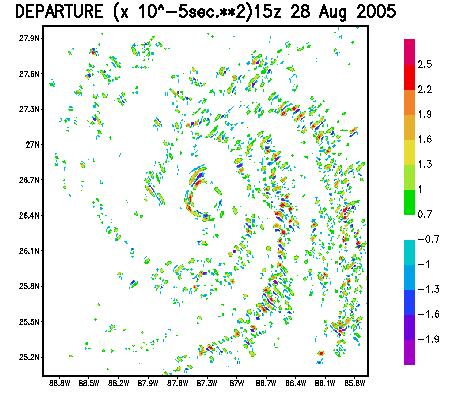
8 Departures from balance laws The full divergence equation can be written in the form (from Fankhauser 1974): Red lines represent the balance equation (Haltiner and Williams 1980). The blue underlined terms denote the non linear balance which is also expressed as. y F x F p D y D v x D u t D D p v y p u x u y v x u y u x v x v y u f v u y x J f, 2 2 2
9
10
11
12
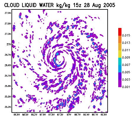
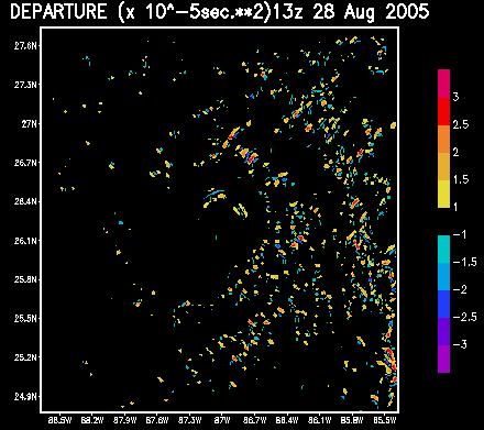
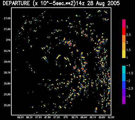
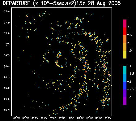
13 We have routinely mapped the field of GWD/ in the intensifying and decaying phases of hurricane intensity. We shall next illustrate several examples of the following scenario: 1. Deep convection flares up near the eye wall, as seen from the local growth of rain water mixing ratio, liquid water mixing ratio or radar reflectivity as implied from model hydrometeors. 2. Divergence flares up 3. Departures from balance laws flare up 4. Solution of complete radial equation shows rapid growth of hurricane intensity.

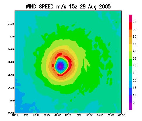
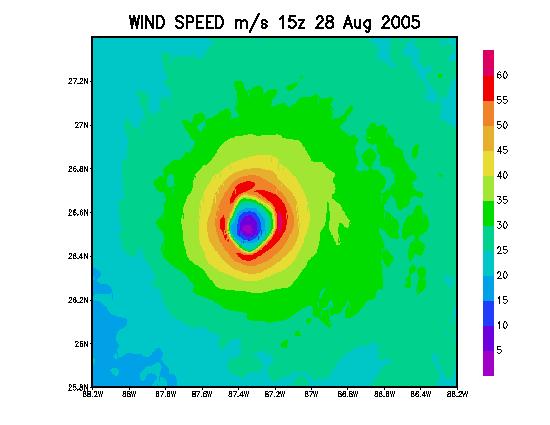
14 These panels correspond closely to the period of maximum intensity of Katrina
15 Hourly plots Cloud Liquid Water 10-5 Initial time: 10z 28 August 2005
16 Hourly plots Cloud Liquid Water 10-5 Initial time: 09z 28 August 2005
17 Hourly plots Cloud Liquid Water 10-5 Initial time: 09z 28 August 2005
18 Hourly plots Cloud Liquid Water 10-5 Initial time: 09z 28 August 2005
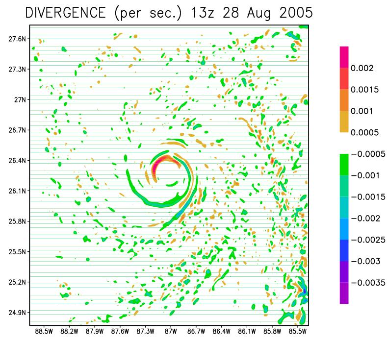
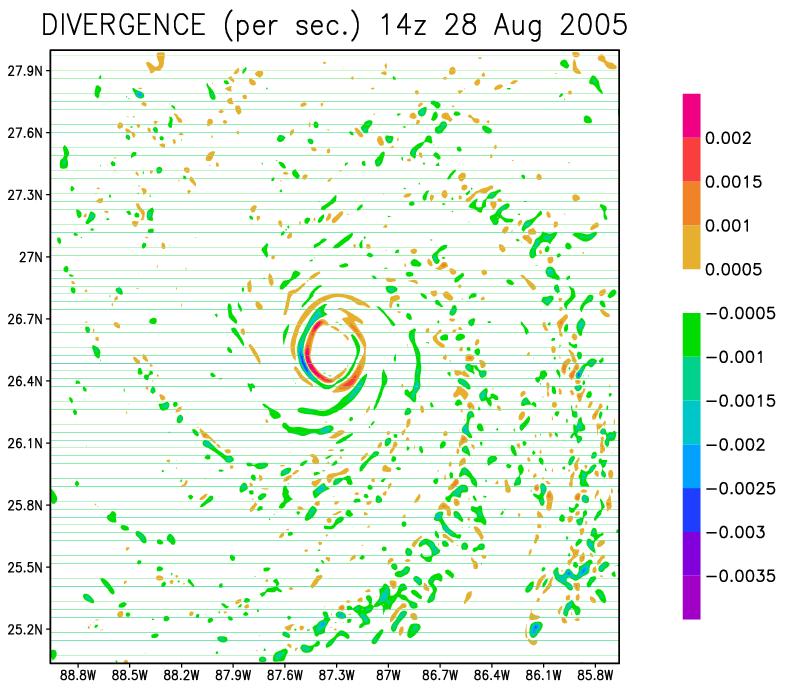
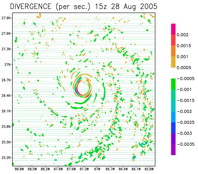
19 DIVERGENCE

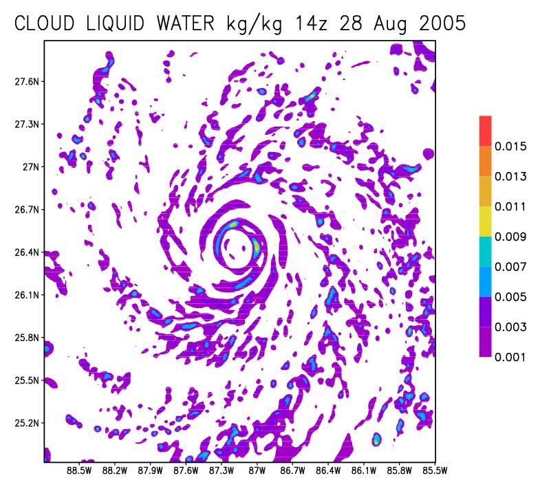
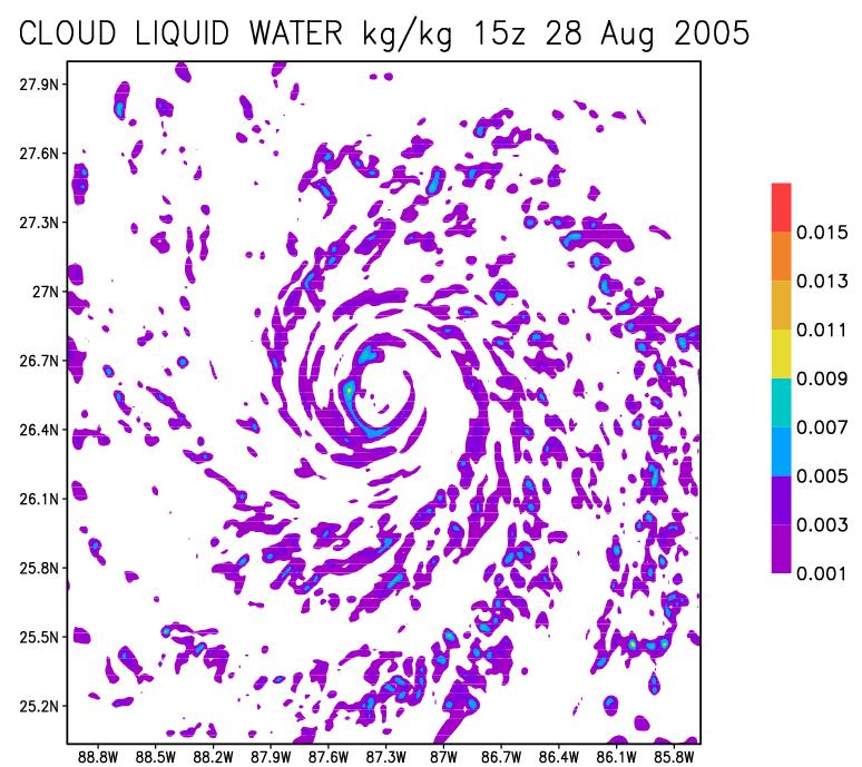
20 CLOUD LIQUID WATER
21
22
23 Life cycle of a cloud
24


25 Observations Required Radar Reflectivity 3-Dimensional Winds Pressure Altitude
26 Vertical differential of heating in the complete potential vorticity equation, a diagnostic tool
27 d (x 10 4 ) K/s PV (x 10-7 ) m 2 s -1 kg -1 K dt PV d dt g p m 2 kg -1 K Hurricane IVAN, 11 September 2004, 12z.10-7 ) m 2 s -1 kg -1 K
28 Contour plots of horizontal advection (x Kg -1 m 2 s -2 K) for hurricane IVAN 7 September through 12 September 2005 at 00z.
29 Contour plots of vertical advection of PV(x Kg -1 m 2 s- 2 K) for hurricane IVAN, 7 September through 12 September 2005 at 00z.
30 Contour plots of vertical differential of heating (x Kg -1 m 2 s -2 K) for hurricane IVAN, 7 September through 12 September 2005 at 00z.
31 Vertical distribution of the Horizontal Advection (green), Vertical Advection (purple), Vertical Differential of heating (Blue), Horizontal Differential of heating (orange) for the Potential Vorticity during the intensifying stage of Hurricane IVAN, through 7 to 12, 2005 at 00z. The total diabatic heating is shown in black. Units are x Kg-1m2s-2K
32 The time rate of change of vertical differential of heating (black solid line) and that for intensity (black dashed line) for the individual hurricanes for the years The abscissa is a relative time scale and ordinate denotes a scale for the time rate of change. Least square fit of the above two curves.
33 We shall next show how the rapid increase of divergent kinetic energy gets transformed into rotational kinetic energy leading to a stronger storm Hurricane Katrina 8/28/05 12Z 8/29/05 15Z Every 3 hours And several other hurricanes during
34 Equations for Psi-Chi Interactions Term 1 Term 2 Term 3 Term 4 t K B f 2 2 ( ) 2 / 2 J, p F The important terms are Term 1 and Term 2 f f 0 0 large f 0 0 f 0 large 0
35 Term 1 Term 2 Term 3 Term 4 t K B f 2 2 ( ) 2 / 2 J, p F There are four terms in the psi-chi interactions, these measure the rate of transfer of divergent kinetic energy into rotational kinetic energy. As deep convection flares up divergent motions amplify and a strong conversion of divergent to rotational motion follows, continually imbalanced flows grow and a rapid intensification of hurricane winds follow.
")
36 f ( ) (m 2 s -3 )
")
37 2 ( ) (m 2 s -3 )
38 These results are averages over 100 km radius at 850 hpa Red line is intensity; Blue line is the sum of the first two terms
39 These results are averages over 100 km radius at 850 hpa Red line is intensity; Blue line is the sum of the first two terms
40 Storm-Relative Eulerian Absolute Angular Momentum Tendencies in Atlantic Tropical Cyclones
 m 2 s 2 V 2 2 m 2 s 2 Strengthening Storms Weakening Storms Strengthening Storms Weakening Storms 150 100 50 0-50 -100-150 150 100")

41 Pressure (hpa) Pressure (hpa) Pressure (hpa) Pressure (hpa) Pressure (hpa) Pressure (hpa) Pressure (hpa) Pressure (hpa) Cross-section Composites of Horizontal Advection in Storms Category 2 and Higher V fr ( ur) m 2 s 2 V 2 2 m 2 s 2 Strengthening Storms Weakening Storms Strengthening Storms Weakening Storms Km from center Km from center Km from center Km from center T-test CI Strengthening - Weakening 120 T-test CI Strengthening - Weakening Km from center Km from center Km from center Km from center
42 Conclusions and future work contd.. Future work on mesoscale modeling during the hurricane season of 2009 will include the following models: HWRF(EMC), HWRF-X(HRD), WRF/ARW (NCAR), COAMPS (NRL),GFDL(NOAA), MM5 (FSU), WRF(FSU). Rapid intensity changes over regions of cloud burst seem to go with growth of lower tropospheric convergence, growth of departure from balance laws and supergradient winds. This scenario appears to carry a lead time of only an hour (roughly) between the time of the cloud burst and the generation of supergradient winds. Local wind maxima thus generated are seen to sweep azimuthal distances of the order of 50 km in a matter of an hour. There are a host of dynamical parameters that deserve to be examined over the inner core of hurricanes for the post processing of model output. We have noted the following to be important, in relating to hurricane intensity changes: vertical differential of heating of the complete pv equation; energy transfer from the divergent to the rotational kinetic energy; advection of earths and relative angular momentum in storm relative coordinates; contributions of the kinematic transfer of shear vorticity to the curvature vorticity.
43 Future work In order to further exploit these findings, we have designed a unified index that is derived from multiple regression for the intensity change using a least square minimization principle that includes all of the above parameters. Such an index would be most useful for real time operations. It should be stated that the parameters we have selected are not all-inclusive; such a list must be expanded and tested as newer ideas develop. The post spin-up data sets are ideally suited for developing single or combined indices for studying the rapid intensification or weakening. A combined index is described by the following multiple regression equation. Intensity Change = ipr i (1) where i are weights determined by a least square minimization principle and PR i are the different candidate parameters. Time rate of change
44 THANKS
Advanced Research WRF High Resolution Simulations of Hurricanes Katrina, Rita and Wilma (2005)
") Advanced Research WRF High Resolution Simulations of Hurricanes Katrina, Rita and Wilma (2005) Kristen L. Corbosiero, Wei Wang, Yongsheng Chen, Jimy Dudhia and Christopher Davis National Center for Atmospheric
Advanced Research WRF High Resolution Simulations of Hurricanes Katrina, Rita and Wilma (2005) Kristen L. Corbosiero, Wei Wang, Yongsheng Chen, Jimy Dudhia and Christopher Davis National Center for Atmospheric
18A.2 PREDICTION OF ATLANTIC TROPICAL CYCLONES WITH THE ADVANCED HURRICANE WRF (AHW) MODEL
 MODEL") 18A.2 PREDICTION OF ATLANTIC TROPICAL CYCLONES WITH THE ADVANCED HURRICANE WRF (AHW) MODEL Jimy Dudhia *, James Done, Wei Wang, Yongsheng Chen, Qingnong Xiao, Christopher Davis, Greg Holland, Richard Rotunno,
18A.2 PREDICTION OF ATLANTIC TROPICAL CYCLONES WITH THE ADVANCED HURRICANE WRF (AHW) MODEL Jimy Dudhia *, James Done, Wei Wang, Yongsheng Chen, Qingnong Xiao, Christopher Davis, Greg Holland, Richard Rotunno,
Prediction of Landfalling Hurricanes with the Advanced Hurricane WRF Model
 1990 M O N T H L Y W E A T H E R R E V I E W VOLUME 136 Prediction of Landfalling Hurricanes with the Advanced Hurricane WRF Model CHRISTOPHER DAVIS,* WEI WANG,* SHUYI S. CHEN, YONGSHENG CHEN,* KRISTEN
The Properties of Convective Clouds Over the Western Pacific and Their Relationship to the Environment of Tropical Cyclones
 The Properties of Convective Clouds Over the Western Pacific and Their Relationship to the Environment of Tropical Cyclones Principal Investigator: Dr. Zhaoxia Pu Department of Meteorology, University
Track sensitivity to microphysics and radiation
 Track sensitivity to microphysics and radiation Robert Fovell and Yizhe Peggy Bu, UCLA AOS Brad Ferrier, NCEP/EMC Kristen Corbosiero, U. Albany 11 April 2012 rfovell@ucla.edu 1 Background WRF-ARW, including
Advanced Hurricane WRF (AHW) Physics
 Physics") Advanced Hurricane WRF (AHW) Physics Jimy Dudhia MMM Division, NCAR 1D Ocean Mixed-Layer Model 1d model based on Pollard, Rhines and Thompson (1973) was added for hurricane forecasts Purpose is to represent
Advanced Hurricane WRF (AHW) Physics Jimy Dudhia MMM Division, NCAR 1D Ocean Mixed-Layer Model 1d model based on Pollard, Rhines and Thompson (1973) was added for hurricane forecasts Purpose is to represent
Improved Tropical Cyclone Boundary Layer Wind Retrievals. From Airborne Doppler Radar
 Improved Tropical Cyclone Boundary Layer Wind Retrievals From Airborne Doppler Radar Shannon L. McElhinney and Michael M. Bell University of Hawaii at Manoa Recent studies have highlighted the importance
Numerical Weather Prediction: Data assimilation. Steven Cavallo
 Numerical Weather Prediction: Data assimilation Steven Cavallo Data assimilation (DA) is the process estimating the true state of a system given observations of the system and a background estimate. Observations
1. Introduction. In following sections, a more detailed description of the methodology is provided, along with an overview of initial results.
 7B.2 MODEL SIMULATED CHANGES IN TC INTENSITY DUE TO GLOBAL WARMING Kevin A. Hill*, Gary M. Lackmann, and A. Aiyyer North Carolina State University, Raleigh, North Carolina 1. Introduction The impact of
Improving Air-Sea Coupling Parameterizations in High-Wind Regimes
 Improving Air-Sea Coupling Parameterizations in High-Wind Regimes PI: Dr. Shuyi S. Chen Co-PI: Dr. Mark A. Donelan Rosenstiel School of Marine and Atmospheric Science, University of Miami 4600 Rickenbacker
Experiments of Hurricane Initialization with Airborne Doppler Radar Data for the Advancedresearch Hurricane WRF (AHW) Model
 Model") Experiments of Hurricane Initialization with Airborne Doppler Radar Data for the Advancedresearch Hurricane WRF (AHW) Model Qingnong Xiao 1, Xiaoyan Zhang 1, Christopher Davis 1, John Tuttle 1, Greg Holland
Experiments of Hurricane Initialization with Airborne Doppler Radar Data for the Advancedresearch Hurricane WRF (AHW) Model Qingnong Xiao 1, Xiaoyan Zhang 1, Christopher Davis 1, John Tuttle 1, Greg Holland
The Energetics of the Rapid Intensification of Hurricane Earl (2010) Daniel Nielsen
 Daniel Nielsen") The Energetics of the Rapid Intensification of Hurricane Earl (2010) Daniel Nielsen A scholarly paper in partial fulfillment of the requirements for the degree of Master of Science August 2016 Department
The Energetics of the Rapid Intensification of Hurricane Earl (2010) Daniel Nielsen A scholarly paper in partial fulfillment of the requirements for the degree of Master of Science August 2016 Department
Motivation & Goal. We investigate a way to generate PDFs from a single deterministic run
 Motivation & Goal Numerical weather prediction is limited by errors in initial conditions, model imperfections, and nonlinearity. Ensembles of an NWP model provide forecast probability density functions
Typhoon Relocation in CWB WRF
 Typhoon Relocation in CWB WRF L.-F. Hsiao 1, C.-S. Liou 2, Y.-R. Guo 3, D.-S. Chen 1, T.-C. Yeh 1, K.-N. Huang 1, and C. -T. Terng 1 1 Central Weather Bureau, Taiwan 2 Naval Research Laboratory, Monterey,
16D.4 Evaluating HWRF Forecasts of Tropical Cyclone Intensity and Structure in the North Atlantic Basin
 16D.4 Evaluating HWRF Forecasts of Tropical Cyclone Intensity and Structure in the North Atlantic Basin Dany Tran* and Sen Chiao Meteorology and Climate Science San Jose State University, San Jose, California
HWRF sensitivity to cumulus schemes
 HWRF sensitivity to cumulus schemes Mrinal K Biswas and Ligia R Bernardet HFIP Telecon, 01 February 2012 Motivation HFIP Regional Model Team Physics Workshop (Aug 11): Foci: Scientific issues on PBL and
Department of Meteorology, University of Utah, Salt Lake City, UT. Second revision. Submitted to Monthly Weather Review.
 Sensitivity of Numerical Simulation of Early Rapid Intensification of Hurricane Emily (2005) to Cloud Microphysical and Planetary Boundary Layer Parameterizations XUANLI LI and ZHAOXIA PU * Department
Key Laboratory of Mesoscale Severe Weather, Ministry of Education, School of Atmospheric Sciences, Nanjing University
 Modeling Rapid Intensification of Typhoon Saomai (2006) with the Weather Research and Forecasting Model and Sensitivity to Cloud Microphysical Parameterizations Jie Ming and Yuan Wang Key Laboratory of
15.6 A NUMERICAL MODELING STUDY OF THE MICROPHYSICAL PROCESSES LEADING TO TROPICAL CYCLOGENESIS UNDER DIFFERENT ENVIRONMENTAL CONDITIONS
 15.6 A NUMERICAL MODELING STUDY OF THE MICROPHYSICAL PROCESSES LEADING TO TROPICAL CYCLOGENESIS UNDER DIFFERENT ENVIRONMENTAL CONDITIONS Andrew B. Penny* and Elizabeth A. Ritchie Department of Atmospheric
Regional Scale Modeling and Numerical Weather Prediction
 Regional Scale Modeling and Numerical Weather Prediction Jimy Dudhia NCAR/MMM Mesoscale & Microscale Meteorological Division / NCAR Overview of talk WRF Modeling System Overview WRF Model Dynamics Physics
Sensitivity of precipitation forecasts to cumulus parameterizations in Catalonia (NE Spain)
") Sensitivity of precipitation forecasts to cumulus parameterizations in Catalonia (NE Spain) Jordi Mercader (1), Bernat Codina (1), Abdelmalik Sairouni (2), Jordi Cunillera (2) (1) Dept. of Astronomy and
Sensitivity of precipitation forecasts to cumulus parameterizations in Catalonia (NE Spain) Jordi Mercader (1), Bernat Codina (1), Abdelmalik Sairouni (2), Jordi Cunillera (2) (1) Dept. of Astronomy and
Influences of Asymmetric Flow Features on Hurricane Evolution
 Influences of Asymmetric Flow Features on Hurricane Evolution Lloyd J. Shapiro Meteorological Institute University of Munich Theresienstr. 37, 80333 Munich, Germany phone +49 (89) 2180-4327 fax +49 (89)
Corresponding author address: Yu Wang, 3141 Turlington Hall, University of Florida, Gainesville, FL
 178 SIMULATING EFFECTS OF LAND SURFACE CHARACTERS ON TPOPICAL CYCLONE RAINFALL PATTERN USING HURRICANE NATURE RUN (HNR) AND WEATHER RESEARCH FORECASTING (WRF) MODEL Yu Wang 1, Jingyin Tang, Corene Matyas
IMPACT OF GROUND-BASED GPS PRECIPITABLE WATER VAPOR AND COSMIC GPS REFRACTIVITY PROFILE ON HURRICANE DEAN FORECAST. (a) (b) (c)
 (b) (c)") 9B.3 IMPACT OF GROUND-BASED GPS PRECIPITABLE WATER VAPOR AND COSMIC GPS REFRACTIVITY PROFILE ON HURRICANE DEAN FORECAST Tetsuya Iwabuchi *, J. J. Braun, and T. Van Hove UCAR, Boulder, Colorado 1. INTRODUCTION
9B.3 IMPACT OF GROUND-BASED GPS PRECIPITABLE WATER VAPOR AND COSMIC GPS REFRACTIVITY PROFILE ON HURRICANE DEAN FORECAST Tetsuya Iwabuchi *, J. J. Braun, and T. Van Hove UCAR, Boulder, Colorado 1. INTRODUCTION
Ensemble Data Assimilation applied to. RAINEX observations of Hurricane Katrina (2005)
") Ensemble Data Assimilation applied to RAINEX observations of Hurricane Katrina (2005) Ryan D. Torn & Gregory J. Hakim University of Washington, Seattle, WA Submitted to Monthly Weather Review May 14, 2008
Ensemble Data Assimilation applied to RAINEX observations of Hurricane Katrina (2005) Ryan D. Torn & Gregory J. Hakim University of Washington, Seattle, WA Submitted to Monthly Weather Review May 14, 2008
Precipitation Structure and Processes of Typhoon Nari (2001): A Modeling Propsective
: A Modeling Propsective") Precipitation Structure and Processes of Typhoon Nari (2001): A Modeling Propsective Ming-Jen Yang Institute of Hydrological Sciences, National Central University 1. Introduction Typhoon Nari (2001) struck
Precipitation Structure and Processes of Typhoon Nari (2001): A Modeling Propsective Ming-Jen Yang Institute of Hydrological Sciences, National Central University 1. Introduction Typhoon Nari (2001) struck
Hurricane Initialization Using Airborne Doppler Radar Data for WRF
 Hurricane Initialization Using Airborne Doppler Radar Data for WRF Qingnong Xiao* 1, Xiaoyan Zhang 1, Christopher Davis 1, John Tuttle 1, Greg Holland 1, Pat Fitzpatrick 2 1. Mesoscale and Microscale Meteorology
A New Ocean Mixed-Layer Model Coupled into WRF
 ATMOSPHERIC AND OCEANIC SCIENCE LETTERS, 2012, VOL. 5, NO. 3, 170 175 A New Ocean Mixed-Layer Model Coupled into WRF WANG Zi-Qian 1,2 and DUAN An-Min 1 1 The State Key Laboratory of Numerical Modeling
Overview of HFIP FY10 activities and results
 Overview of HFIP FY10 activities and results Bob Gall HFIP Annual Review Meeting Miami Nov 9, 2010 Outline In this presentation I will show a few preliminary results from the summer program. More detail
Initialization of Tropical Cyclone Structure for Operational Application
 DISTRIBUTION STATEMENT A. Approved for public release; distribution is unlimited. Initialization of Tropical Cyclone Structure for Operational Application PI: Tim Li IPRC/SOEST, University of Hawaii at
Toward Developing an Objective 4DVAR BDA Scheme for Hurricane Initialization Based on TPC Observed Parameters
 2054 MONTHLY WEATHER REVIEW VOLUME 132 Toward Developing an Objective 4DVAR BDA Scheme for Hurricane Initialization Based on TPC Observed Parameters KYUNGJEEN PARK AND X. ZOU Department of Meteorology,
EARLY ONLINE RELEASE
 AMERICAN METEOROLOGICAL SOCIETY Weather and Forecasting EARLY ONLINE RELEASE This is a preliminary PDF of the author-produced manuscript that has been peer-reviewed and accepted for publication. Since
The role of mid-level vortex in the intensification and weakening of tropical cyclones
 J. Earth Syst. Sci. (2017) 126:94 c Indian Academy of Sciences DOI 10.1007/s12040-017-0879-y The role of mid-level vortex in the intensification and weakening of tropical cyclones Govindan Kutty* and Kanishk
Variational data assimilation of lightning with WRFDA system using nonlinear observation operators
 Variational data assimilation of lightning with WRFDA system using nonlinear observation operators Virginia Tech, Blacksburg, Virginia Florida State University, Tallahassee, Florida rstefane@vt.edu, inavon@fsu.edu
Tropical Cyclone Formation: Results
 Tropical Cyclone Formation: Results from PREDICT (PRE Depression Investigation of Cloud systems in the Tropics) collaborator on this presentation: Dave Ahijevych (NCAR) Chris Davis National Center for
ARW/EnKF performance for the 2009 Hurricane Season
 ARW/EnKF performance for the 2009 Hurricane Season Ryan D. Torn, Univ. at Albany, SUNY Chris Davis, Steven Cavallo, Chris Snyder, Wei Wang, James Done, NCAR/MMM 4 th EnKF Workshop 8 April 2010, Rensselaerville,
1C.4 TROPICAL CYCLONE TORNADOES: SYNOPTIC SCALE INFLUENCES AND FORECASTING APPLICATIONS
 1C.4 TROPICAL CYCLONE TORNADOES: SYNOPTIC SCALE INFLUENCES AND FORECASTING APPLICATIONS Daniel J. Cecil and Lori A. Schultz University of Alabama in Huntsville, Huntsville, AL, 35805 1. INTRODUCTION Several
The Effect of Sea Spray on Tropical Cyclone Intensity
 The Effect of Sea Spray on Tropical Cyclone Intensity Jeffrey S. Gall, Young Kwon, and William Frank The Pennsylvania State University University Park, Pennsylvania 16802 1. Introduction Under high-wind
University of Miami/RSMAS
 Observing System Simulation Experiments to Evaluate the Potential Impact of Proposed Observing Systems on Hurricane Prediction: R. Atlas, T. Vukicevic, L.Bucci, B. Annane, A. Aksoy, NOAA Atlantic Oceanographic
2012 AHW Stream 1.5 Retrospective Results
 2012 AHW Stream 1.5 Retrospective Results Ryan D. Torn, Univ. Albany, SUNY Chris Davis, Wei Wang, Jimy Dudhia, Tom Galarneau, Chris Snyder, James Done, NCAR/NESL/MMM Overview Since participation in HFIP
Mélicie Desflots* RSMAS, University of Miami, Miami, Florida
 15B.6 RAPID INTENSITY CHANGE IN HURRICANE LILI (2002) Mélicie Desflots* RSMAS, University of Miami, Miami, Florida 1. INTRODUCTION Rapid intensity change in tropical cyclones is one of the most difficult
Structure and Formation of an Annular Hurricane Simulated in a Fully Compressible, Nonhydrostatic Model TCM4*
 MAY 2008 W A N G 1505 Structure and Formation of an Annular Hurricane Simulated in a Fully Compressible, Nonhydrostatic Model TCM4* YUQING WANG International Pacific Research Center, and Department of
P Hurricane Danielle Tropical Cyclogenesis Forecasting Study Using the NCAR Advanced Research WRF Model
 P1.2 2004 Hurricane Danielle Tropical Cyclogenesis Forecasting Study Using the NCAR Advanced Research WRF Model Nelsie A. Ramos* and Gregory Jenkins Howard University, Washington, DC 1. INTRODUCTION Presently,
Impact of Turbulence on the Intensity of Hurricanes in Numerical Models* Richard Rotunno NCAR
 Impact of Turbulence on the Intensity of Hurricanes in Numerical Models* Richard Rotunno NCAR *Based on: Bryan, G. H., and R. Rotunno, 2009: The maximum intensity of tropical cyclones in axisymmetric numerical
Inner core dynamics: Eyewall Replacement and hot towers
 Inner core dynamics: Eyewall Replacement and hot towers FIU Undergraduate Hurricane Internship Lecture 4 8/13/2012 Why inner core dynamics is important? Current TC intensity and structure forecasts contain
Developmental Testbed Center (DTC) Project for the Hurricane Forecast Improvement Program (HFIP)
 Project for the Hurricane Forecast Improvement Program (HFIP)") Developmental Testbed Center (DTC) Project for the Hurricane Forecast Improvement Program (HFIP) Final report documenting: Regional Application of the GSI- Hybrid Data Assimilation for Tropical Storm forecasts
Developmental Testbed Center (DTC) Project for the Hurricane Forecast Improvement Program (HFIP) Final report documenting: Regional Application of the GSI- Hybrid Data Assimilation for Tropical Storm forecasts
Impact of GPS RO Data on the Prediction of Tropical Cyclones
 Impact of GPS RO Data on the Prediction of Tropical Cyclones Ying-Hwa Kuo, Hui Liu, UCAR Ching-Yuang Huang, Shu-Ya Chen, NCU Ling-Feng Hsiao, Ming-En Shieh, Yu-Chun Chen, TTFRI Outline Tropical cyclone
SIMULATION OF ATMOSPHERIC STATES FOR THE CASE OF YEONG-GWANG STORM SURGE ON 31 MARCH 2007 : MODEL COMPARISON BETWEEN MM5, WRF AND COAMPS
 SIMULATION OF ATMOSPHERIC STATES FOR THE CASE OF YEONG-GWANG STORM SURGE ON 31 MARCH 2007 : MODEL COMPARISON BETWEEN MM5, WRF AND COAMPS JEONG-WOOK LEE 1 ; KYUNG-JA HA 1* ; KI-YOUNG HEO 1 ; KWANG-SOON
Cloud-Resolving Simulations of West Pacific Tropical Cyclones
 Cloud-Resolving Simulations of West Pacific Tropical Cyclones Da-Lin Zhang Department of Atmospheric and Oceanic Science, University of Maryland College Park, MD 20742-2425 Phone: (301) 405-2018; Fax:
Atmosphere-Ocean Interaction in Tropical Cyclones
 Atmosphere-Ocean Interaction in Tropical Cyclones Isaac Ginis University of Rhode Island Collaborators: T. Hara, Y.Fan, I-J Moon, R. Yablonsky. ECMWF, November 10-12, 12, 2008 Air-Sea Interaction in Tropical
Tropical Cyclone Intensity and Structure Changes in relation to Tropical Cyclone Outflow
 DISTRIBUTION STATEMENT A. Approved for public release; distribution is unlimited. Tropical Cyclone Intensity and Structure Changes in relation to Tropical Cyclone Outflow Patrick A. Harr Department of
8C.6 Idealized simulations of the impact of dry Saharan air on Atlantic hurricanes
 8C.6 Idealized simulations of the impact of dry Saharan air on Atlantic hurricanes Scott A. Braun #, Jason Sippel #, and David Nolan* #Laboratory for Atmospheres, NASA/Goddard Space Flight Center, Greenbelt,
A Numerical Study of the Impact of Vertical Shear on the Distribution of Rainfall in Hurricane Bonnie (1998)
") AUGUST 2003 ROGERS ET AL. 1577 A Numerical Study of the Impact of Vertical Shear on the Distribution of Rainfall in Hurricane Bonnie (1998) ROBERT ROGERS Cooperative Institute for Marine and Atmospheric
AUGUST 2003 ROGERS ET AL. 1577 A Numerical Study of the Impact of Vertical Shear on the Distribution of Rainfall in Hurricane Bonnie (1998) ROBERT ROGERS Cooperative Institute for Marine and Atmospheric
Impact of Physics Representations in the HWRFX on Simulated Hurricane Structure and Pressure Wind Relationships
 3278 M O N T H L Y W E A T H E R R E V I E W VOLUME 140 Impact of Physics Representations in the HWRFX on Simulated Hurricane Structure and Pressure Wind Relationships J.-W. BAO NOAA/ESRL, Boulder, Colorado
Notes and Correspondence Impact of land-surface roughness on surface winds during hurricane landfall
 QUARTERLY JOURNAL OF THE ROYAL METEOROLOGICAL SOCIETY Q. J. R. Meteorol. Soc. 134: 151 157 (28) Published online 4 June 28 in Wiley InterScience (www.interscience.wiley.com) DOI: 1.12/qj.265 Notes and
DISTRIBUTION STATEMENT A: Distribution approved for public release; distribution is unlimited.
 DISTRIBUTION STATEMENT A: Distribution approved for public release; distribution is unlimited. INITIALIZATION OF TROPICAL CYCLONE STRUCTURE FOR OPERTAIONAL APPLICATION PI: Tim Li IPRC/SOEST, University
608 SENSITIVITY OF TYPHOON PARMA TO VARIOUS WRF MODEL CONFIGURATIONS
 608 SENSITIVITY OF TYPHOON PARMA TO VARIOUS WRF MODEL CONFIGURATIONS Phillip L. Spencer * and Brent L. Shaw Weather Decision Technologies, Norman, OK, USA Bonifacio G. Pajuelas Philippine Atmospheric,
Department of Marine, Earth and Atmospheric Sciences, North Carolina State University, Raleigh, North Carolina
 FEBRUARY 2009 H I L L A N D L A C K M A N N 745 Analysis of Idealized Tropical Cyclone Simulations Using the Weather Research and Forecasting Model: Sensitivity to Turbulence Parameterization and Grid
Weather Research and Forecasting Model. Melissa Goering Glen Sampson ATMO 595E November 18, 2004
 Weather Research and Forecasting Model Melissa Goering Glen Sampson ATMO 595E November 18, 2004 Outline What does WRF model do? WRF Standard Initialization WRF Dynamics Conservation Equations Grid staggering
Comparison of Typhoon Track Forecast using Dynamical Initialization Schemeinstalled
 IWTC-LP 9 Dec 2014, Jeju, Korea Comparison of Typhoon Track Forecast using Dynamical Initialization Schemeinstalled WRF Hyeonjin Shin, WooJeong Lee, KiRyong Kang, 1) Dong-Hyun Cha and Won-Tae Yun National
Impacts of Turbulence on Hurricane Intensity
 Impacts of Turbulence on Hurricane Intensity Yongsheng Chen Department of Earth and Space Science and Engineering York University, 4700 Keele Street, Toronto, Ontario, M3J 1P3 Phone: (416) 736-2100 ext.40124
Thunderstorm-Scale EnKF Analyses Verified with Dual-Polarization, Dual-Doppler Radar Data
 Thunderstorm-Scale EnKF Analyses Verified with Dual-Polarization, Dual-Doppler Radar Data David Dowell and Wiebke Deierling National Center for Atmospheric Research, Boulder, CO Ensemble Data Assimilation
Assignment #5: Cumulus Parameterization Sensitivity Due: 14 November 2017
 Assignment #5: Cumulus Parameterization Sensitivity Due: 14 November 2017 Objectives In this assignment, we use the WRF-ARW model to run two nearly-identical simulations in which only the cumulus parameterization
Investigating the Environment of the Indiana and Ohio Tornado Outbreak of 24 August 2016 Using a WRF Model Simulation 1.
 Investigating the Environment of the Indiana and Ohio Tornado Outbreak of 24 August 2016 Using a WRF Model Simulation Kevin Gray and Jeffrey Frame Department of Atmospheric Sciences, University of Illinois
THE IMPACT OF SATELLITE-DERIVED WINDS ON GFDL HURRICANE MODEL FORECASTS
 THE IMPACT OF SATELLITE-DERIVED WINDS ON GFDL HURRICANE MODEL FORECASTS Brian J. Soden 1 and Christopher S. Velden 2 1) Geophysical Fluid Dynamics Laboratory National Oceanic and Atmospheric Administration
Ensemble Data Assimilation Applied to RAINEX Observations of Hurricane Katrina (2005)
") SEPTEMBER 2009 T O R N A N D H A K I M 2817 Ensemble Data Assimilation Applied to RAINEX Observations of Hurricane Katrina (2005) RYAN D. TORN AND GREGORY J. HAKIM University of Washington, Seattle, Washington
SEPTEMBER 2009 T O R N A N D H A K I M 2817 Ensemble Data Assimilation Applied to RAINEX Observations of Hurricane Katrina (2005) RYAN D. TORN AND GREGORY J. HAKIM University of Washington, Seattle, Washington
Simulating the formation of Hurricane Katrina (2005)
") GEOPHYSICAL RESEARCH LETTERS, VOL. 35, L11802, doi:10.1029/2008gl033168, 2008 Simulating the formation of Hurricane Katrina (2005) Yi Jin, 1 Melinda S. Peng, 1 and Hao Jin 2 Received 2 January 2008; revised
GEOPHYSICAL RESEARCH LETTERS, VOL. 35, L11802, doi:10.1029/2008gl033168, 2008 Simulating the formation of Hurricane Katrina (2005) Yi Jin, 1 Melinda S. Peng, 1 and Hao Jin 2 Received 2 January 2008; revised
Dependence of tropical cyclone intensification on the Coriolis parameter
 May 2012 Li et al. 1 Dependence of tropical cyclone intensification on the Coriolis parameter Tim Li a n d Xu ya n g Ge Department of Meteorology and IPRC, University of Hawaii, Honolulu, Hawaii Melinda
Assimilate W88D Doppler Vr for Humberto 05
 Assimilate W88D Doppler Vr for Humberto 05 WRF/EnKF Forecast vs. Observations vs. 3DVAR Min SLP Max wind The WRF/3DVAR (as a surrogate of operational algorithm) assimilates the same radar data but without
Sensitivity of intensifying Atlantic hurricanes to vortex structure
 Quarterly Journal of the Royal Meteorological Society Q. J. R. Meteorol. Soc. (5) DOI:./qj.54 Sensitivity of intensifying Atlantic hurricanes to vortex structure Bonnie R. Brown a,b * and Gregory J. Hakim
Influence of Rain-Rate Initialization, Cloud Microphysics, and Cloud Torques on Hurricane Intensity
 FEBRUARY 2011 P A T T N A I K E T A L. 627 Influence of Rain-Rate Initialization, Cloud Microphysics, and Cloud Torques on Hurricane Intensity S. PATTNAIK Indian Institute of Tropical Meteorology, Pashan,
8.3 A STUDY OF AIR-SEA INTERACTIONS AND ASSOCIATED TROPICAL HURRICANE ACTIVITY OVER GULF OF MEXICO USING SATELLITE DATA AND NUMERICAL MODELING
 8.3 A STUDY OF AIR-SEA INTERACTIONS AND ASSOCIATED TROPICAL HURRICANE ACTIVITY OVER GULF OF MEXICO USING SATELLITE DATA AND NUMERICAL MODELING R. Suseela Reddy*, Alexander Schwartz, Praveena Remata, Jamese
P4.10. Kenichi Kusunoki 1 * and Wataru Mashiko 1 1. Meteorological Research Institute, Japan
 P4. DOPPLER RADAR INVESTIGATIONS OF THE INNER CORE OF TYPHOON SONGDA (24) Polygonal / elliptical eyewalls, eye contraction, and small-scale spiral bands. Kenichi Kusunoki * and Wataru Mashiko Meteorological
Tropical Cyclone Formation/Structure/Motion Studies
 Tropical Cyclone Formation/Structure/Motion Studies Patrick A. Harr Department of Meteorology Naval Postgraduate School Monterey, CA 93943-5114 phone: (831) 656-3787 fax: (831) 656-3061 email: paharr@nps.edu
TOWARDS A BETTER UNDERSTANDING OF AND ABILITY TO FORECAST THE WIND FIELD EXPANSION DURING THE EXTRATROPICAL TRANSITION PROCESS
 P1.17 TOWARDS A BETTER UNDERSTANDING OF AND ABILITY TO FORECAST THE WIND FIELD EXPANSION DURING THE EXTRATROPICAL TRANSITION PROCESS Clark Evans* and Robert E. Hart Florida State University Department
10D.2 Methods for Introducing Vortical Hot Tower Heating in Numerical Models: Retrieving Latent Heat
 10D.2 Methods for Introducing Vortical Hot Tower Heating in Numerical Models: Retrieving Latent Heat Stephen R. Guimond Florida State University, Department of Meteorology and Center for Ocean-Atmospheric
P1.6 Simulation of the impact of new aircraft and satellite-based ocean surface wind measurements on H*Wind analyses
 P1.6 Simulation of the impact of new aircraft and satellite-based ocean surface wind measurements on H*Wind analyses Timothy L. Miller 1, R. Atlas 2, P. G. Black 3, J. L. Case 4, S. S. Chen 5, R. E. Hood
Radiance assimilation in studying Hurricane Katrina
 GEOPHYSICAL RESEARCH LETTERS, VOL. 33, L22811, doi:10.1029/2006gl027543, 2006 Radiance assimilation in studying Hurricane Katrina Quanhua Liu 1,2 and Fuzhong Weng 3 Received 11 July 2006; revised 12 September
PUBLICATIONS. Journal of Advances in Modeling Earth Systems
 PUBLICATIONS Journal of Advances in Modeling Earth Systems RESEARCH ARTICLE 10.1002/2016MS000709 Key Points: Eye excess energy results predominantly from surface entropy flux in the eye region of a TC
Impact of different cumulus parameterizations on the numerical simulation of rain over southern China
 Impact of different cumulus parameterizations on the numerical simulation of rain over southern China P.W. Chan * Hong Kong Observatory, Hong Kong, China 1. INTRODUCTION Convective rain occurs over southern
ABSTRACT 3 RADIAL VELOCITY ASSIMILATION IN BJRUC 3.1 ASSIMILATION STRATEGY OF RADIAL
 REAL-TIME RADAR RADIAL VELOCITY ASSIMILATION EXPERIMENTS IN A PRE-OPERATIONAL FRAMEWORK IN NORTH CHINA Min Chen 1 Ming-xuan Chen 1 Shui-yong Fan 1 Hong-li Wang 2 Jenny Sun 2 1 Institute of Urban Meteorology,
Impact of cloud microphysics on hurricane track forecasts
 Click Here for Full Article GEOPHYSICAL RESEARCH LETTERS, VOL. 34, L24810, doi:10.1029/2007gl031723, 2007 Impact of cloud microphysics on hurricane track forecasts Robert G. Fovell 1 and Hui Su 2 Received
Florida State University Libraries
 Florida State University Libraries Electronic Theses, Treatises and Dissertations The Graduate School 2009 Storm-Relative Eulerian Absolute Angular Momentum Tendency in Atlantic Tropical Cyclones: Advection
High-Resolution Simulation of Hurricane Bonnie (1998). Part I: The Organization of Eyewall Vertical Motion
. Part I: The Organization of Eyewall Vertical Motion") JANUARY 2006 BRAUN ET AL. 19 High-Resolution Simulation of Hurricane Bonnie (1998). Part I: The Organization of Eyewall Vertical Motion SCOTT A. BRAUN Mesoscale Atmospheric Processes Branch, Laboratory
JANUARY 2006 BRAUN ET AL. 19 High-Resolution Simulation of Hurricane Bonnie (1998). Part I: The Organization of Eyewall Vertical Motion SCOTT A. BRAUN Mesoscale Atmospheric Processes Branch, Laboratory
Water and energy budgets of hurricanes: Case studies of Ivan and Katrina
 Click Here for Full Article JOURNAL OF GEOPHYSICAL RESEARCH, VOL. 112,, doi:10.1029/2006jd008303, 2007 Water and energy budgets of hurricanes: Case studies of Ivan and Katrina Kevin E. Trenberth, 1 Christopher
Transitioning Physics Advancements into the Operational Hurricane WRF Model
 Transitioning Physics Advancements into the Operational Hurricane WRF Model KATHRYN NEWMAN, MRINAL BISWAS, LAURIE CARSON N OA A / ESR L T EA M M E M B E RS: E. K ALINA, J. F RIMEL, E. GRELL, AND L. B ERNARDET
University of Oklahoma, Norman, Oklahoma. June 6, 2012 Submitted to Weather and Forecasting Revised November 3, 2012
 Track and Intensity Forecasting of Hurricanes: Impact of Convection-Permitting Resolution and Global Ensemble Kalman Filter Analysis on 2010 Atlantic Season Forecasts Ming Xue 1,2 *, Jordan Schleif 1,2,
SUPPLEMENTAL MATERIALS FOR:
 SUPPLEMENTAL MATERIALS FOR: Simulated reduction in Atlantic hurricane frequency under 21 st century warming conditions Thomas R. Knutson, Joseph J. Sirutis, Stephen T. Garner, Gabriel A. Vecchi, and Isaac
Impact of airborne Doppler wind lidar profiles on numerical simulations of a tropical cyclone
 Click Here for Full Article GEOPHYSICAL RESEARCH LETTERS, VOL. 37,, doi:10.1029/2009gl041765, 2010 Impact of airborne Doppler wind lidar profiles on numerical simulations of a tropical cyclone Zhaoxia
Corene J. Matyas *, Jingyin Tang, Stephanie E. Zick University of Florida, Gainesville, Florida 2. WSR-88D REFLECTIVITY PROCESSING 1.
 PERFORMING SPATIAL ANALYSIS ON TROPICAL CYCLONE RAINBAND STRUCTURES AFTER CREATING A 3D MOSAIC OF WSR-88D REFLECTIVITY DATA USING A MAP-REDUCE FRAMEWORK AND A GEOGRAPHIC INFORMATION SYSTEM (GIS) 106 Corene
A New Typhoon Bogus Data Assimilation and its Sampling Method: A Case Study
 ATMOSPHERIC AND OCEANIC SCIENCE LETTERS, 2011, VOL. 4, NO. 5, 276 280 A New Typhoon Bogus Data Assimilation and its Sampling Method: A Case Study WANG Shu-Dong 1,2, LIU Juan-Juan 2, and WANG Bin 2 1 Meteorological
Meteorology Lecture 24
 Meteorology Lecture 24 Robert Fovell rfovell@albany.edu 1 Important notes These slides show some figures and videos prepared by Robert G. Fovell (RGF) for his Meteorology course, published by The Great
SIMULATION OF ARCTIC STORMS 7B.3. Zhenxia Long 1, Will Perrie 1, 2 and Lujun Zhang 2
 7B.3 SIMULATION OF ARCTIC STORMS Zhenxia Long 1, Will Perrie 1, 2 and Lujun Zhang 2 1 Fisheries & Oceans Canada, Bedford Institute of Oceanography, Dartmouth NS, Canada 2 Department of Engineering Math,
The impact of assimilation of microwave radiance in HWRF on the forecast over the western Pacific Ocean
 The impact of assimilation of microwave radiance in HWRF on the forecast over the western Pacific Ocean Chun-Chieh Chao, 1 Chien-Ben Chou 2 and Huei-Ping Huang 3 1Meteorological Informatics Business Division,
Xuanli LI and Zhaoxia PU. Department of Atmospheric Sciences, University of Utah, Salt Lake City, Utah, USA
 Journal of the Meteorological Society of Japan, Vol. 87, No. 3, pp. 403--421, 2009. 403 DOI:10.2151/jmsj.87.403 Sensitivity of Numerical Simulations of the Early Rapid Intensification of Hurricane Emily
Sensitivity of tropical cyclone Jal simulations to physics parameterizations
 Sensitivity of tropical cyclone Jal simulations to physics parameterizations R Chandrasekar and C Balaji Department of Mechanical Engineering, Indian Institute of Technology, Madras, Chennai 6 36, India.
PUBLICATIONS. Journal of Advances in Modeling Earth Systems
 PUBLICATIONS Journal of Advances in Modeling Earth Systems RESEARCH ARTICLE 1.1/13MS97 Key Points: Predictability of Hurricane Sandy (1) track and precipitation forecasts Uncertainties in environmental
Upgrade of JMA s Typhoon Ensemble Prediction System
 Upgrade of JMA s Typhoon Ensemble Prediction System Masayuki Kyouda Numerical Prediction Division, Japan Meteorological Agency and Masakazu Higaki Office of Marine Prediction, Japan Meteorological Agency
COAMPS-TC 2015 Version, Performance, and Future Plans
 COAMPS-TC 2015 Version, Performance, and Future Plans James D. Doyle, R. Hodur 1, J. Moskaitis, S. Chen, E. Hendricks 2, H. Jin, Y. Jin, A. Reinecke, S. Wang Naval Research Laboratory, Monterey, CA 1 IES/SAIC,
Improving Tropical Cyclone Guidance Tools by Accounting for Variations in Size
 Improving Tropical Cyclone Guidance Tools by Accounting for Variations in Size John A. Knaff 1, Mark DeMaria 1, Scott P. Longmore 2 and Robert T. DeMaria 2 1 NOAA Center for Satellite Applications and