Impact of different cumulus parameterizations on the numerical simulation of rain over southern China
|
|
|
- Paul Ryan
- 5 years ago
- Views:
Transcription
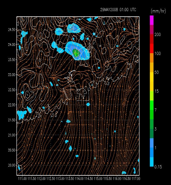
1 Impact of different cumulus parameterizations on the numerical simulation of rain over southern China P.W. Chan * Hong Kong Observatory, Hong Kong, China 1. INTRODUCTION Convective rain occurs over southern China mostly in late spring and summer time. It could be brought about by troughs of low pressure and tropical cyclones. Successful simulation of the rain occurrence by numerical weather prediction (NWP) models would benefit the day-to-day weather forecasting services. At the Hong Kong Observatory (HKO), the operational NWP model suite consists of mesoscale model covering southern China with a spatial resolution of tens of kilometres, which is then nested downwards to microscale model over the region near Hong Kong with a spatial resolution of a couple of kilometres. Whereas convective development may be explicitly simulated in the latter model, cumulus parameterization would still be required in the mesoscale model. Moreover, due to limitation of computing power, it is still not practical to conduct operational simulation of rain occurrence over the whole southern China with explicit modelling of convective development. As a result, it is useful to examine the performance of the various cumulus parameterization schemes for numerical simulation with a spatial resolution in the order of 10 km. In the present paper, the cumulus parameterization schemes of Regional Atmospheric Modelling System (RAMS) version 4.4 would be examined. In the original version of RAMS, only one cumulus parameterization scheme is available, namely, the Kuo scheme. Later on, the Kain Fritsch (KF) scheme has also been implemented. Recently, there is also a modified version of KF scheme available in RAMS. At the same time, RAMS may be run without the cumulus parameterization scheme and with the turbulent mixing at the top of the cloud switched off. The performance of the various simulation methods was studied by considering two typical cases of heavy rain over southern China, one associated with a surface trough of low pressure and another brought about with the passage of a tropical cyclone. 2. PARAMETERIZATION SCHEMES In the original version 4.4 of RAMS, only the Kuo scheme of cumulus parameterization is available. A review of Kuo scheme is given in Stensrud (2007). This scheme is one of the earliest proposed convective schemes and remains one of the most popular schemes for parameterizing cumulus convection. It is also computationally less demanding as compared with the other more modern schemes. In essence, Kuo scheme relates * Corresponding author address: P.W. Chan, Hong Kong Observatory, 134A Nathan Road, Hong Kong pwchan@hko.gov.hk convective activity to total column moisture convergence. The precipitation rate PR is assumed to be related to: PR = (1-b)M t. In the above formula, M t is called moisture accession and represents the total moisture convergence into the vertical column from the surface to the top of the atmosphere, thus including the surface moisture flux. The parameter b defines the fraction of total moisture convergence that is stored in the atmosphere. As a result, (1-b) defines the fraction that is precipitated and used to heat the atmosphere. The total heating that convection produces could thus be derived, giving the time rate of change of potential temperature. The vertical structure of the heating is assumed to be in a form that relaxes towards a moist adiabatic, often specified as originating in the boundary layer. The time over which the scheme adjusts the atmosphere to the assumed potential temperature profile depends upon M t. A review of the implementation of KF scheme in RAMS is given in Truong et al. (2009). This scheme has five main features: (a) trigger function It decides when and where deep convection should occur. Beginning at the surface, updraft source layers are determined to include vertically adjacent model layers whose total depth is at least 50 hpa. The parcel is lifted to its lifting condensation level (LCL). A temperature perturbation is added to its temperature at LCL and a check is done to see if convection initiates; (b) moist convective updraft Updraft mass flux at LCL is computed. The component loops from LCL to the cloud top. Within the loop, the component checks if the parcel is supersaturated, then the compensate is computed. Next, the component computes precipitation generated within the updraft, along with liquid and solid precipitation generated at the given model level as a function of the updraft velocity. The updraft entrainment and detrainment rates are also computed; (c) moist convective downdraft Precipitation efficiency and downdraft entrainment rate are computed. The downdraft parcel evaporates water on its decent from the LCL. At each model level, this evaporated water is determined and the net generated precipitation is computed; (d) compensating circulation After updraft and downdraft fluxes are determined, the scheme computes compensating mass flux so that the net vertical mass flux at any level is zero. The compensating mass flux is equal to the sum of entrainment and detrainment caused by updraft and downdraft; and finally (e) closure assumption It is to remove (at least 90% of) CAPE over the convective time scale (30 minutes to 1 hour), which is defined as: CT Tu ( T( CAPE g dz LCL T(
2 where CT is the cloud top, T the virtual absolute temperature. The subscript u denotes the updraft variables, and the overbar denotes the grid-scale variables. g is the acceleration due to gravity. A modified version of KF scheme has been implemented in RAMS (Truong, 2009). By considering pressure perturbation and buoyant force (PDB) for the updrafts, a new diagnostic equation is determined to compute the updraft velocity, closure assumption and trigger function. For instance, the closure assumption has been revised to be: CT Tu ( T( CAPE g [1 PDB ( ] dz. LCL T( From the above equation, deep convection can be maintained with negative buoyancy provided that the vertical gradient of pressure perturbation is positive and large enough. Similar changes are made to the trigger function and the updraft velocity at LCL. 3. MODEL SETUP The outer model is the Operational Regional Spectral Model (ORSM) of HKO with a spatial resolution of 20 km. It is nested directly with RAMS with a spatial resolution of 9 km. The cumulus parameterization schemes described in Section 2 are used in separate model runs. In addition, there are two model runs with the cumulus parameterization scheme switched off. In these two model runs, one is performed with the original setting of RAMS in which turbulent mixing at the top of the cloud is maintained. In the other model run, this turbulent mixing is switched off by setting a flag in the turbulence module of RAMS 4.4, as in Szeto and Chan (2006). Turbulence is parameterized in the model based on a simplified second-order closure method that employs a prognostic turbulence kinetic energy (TKE) equation (Mellor and Yamada 1982). The shortwave and longwave radiation schemes (Chen and Cotton 1983) consider cloud effects in calculating the heating and cooling caused by radiative flux divergences. 4. TROPICAL CYCLONE CASE The first case in this study is Typhoon Neoguri in April In the morning of 19 April 2008, Neoguri was located at about 300 km to the southwest of Hong Kong over the northern part of the South China Sea. It continued to move northeast and made landfall over western coast of Guangdong. After making landfall, it remained on a northeasterly track over the inland areas. Neoguri brought heavy rain to Hong Kong on its movement over inland Guangdong. Between 4 and 8 p.m. on that day (Hong Kong time = UTC + 8 hours), a total of millimetres of rainfall were recorded at the HKO Headquarters. This necessitated the issuance of black rainstorm warning in Hong Kong, which means the occurrence of widespread heavy rain over the territory with an hourly rainfall of 70 mm or more. The radar picture at 6 p.m. on 19 April 2008 is shown in Figure 1(a). Model simulation is performed starting at 06 UTC. The four-hour forecasts (10 UTC) of the various model runs are shown in Figures 1(b) to (f), corresponding to (i) cumulus parameterization switched off, and with cloud-top turbulent mixing; (ii) cumulus parameterization switched off, and with cloud-top mixing switched off as well; (iii) Kuo scheme; (iv) KF scheme; and (v) modified KF scheme, respectively. The five simulations forecast the rain band of the tropical cyclone reasonably well. However, in terms of the spatial extent of the rain band (particularly the occurrence of heavy rain over the Pearl River Estuary to the west of Hong Kong), the first three simulations appear to be better. Among these three, the switching off of cloud-top turbulent mixing appears to overestimate the rainfall intensity, with the instantaneous rainfall rate reaching 100 mm per hour (coloured red in Figure 1(c)). 5. MONSOON TROUGH CASE In the morning of 29 May 2008, a trough of low pressure lingered over the southern coast of China, bringing heavy rain to the region. Between 9 and 11 a.m. on that day, more than 60 mm of rain was recorded at the HKO Headquarters in the urban area. Model simulation is performed starting at 21 UTC, 28 May 2008 (5 a.m. the following day). The radar picture at 9 a.m., 29 May 2008 is shown in Figure 2(a). The four-hour simulation results of the various model runs are given in Figures 2(b) to (f) respectively, corresponding to the same selections of cumulus parameterization schemes and cloud-top turbulent mixing as in Figure 1 (as described in Section 4 above). It could be seen that, once again, the first three forecasts appear to be better, particularly in the forecasting of the occurrence of rain near the coast of Guangdong. Among them, the model run with the switching off of both cumulus parameterization and cloud-top turbulent mixing (Figure 2(c)) even forecasts the rain over and to the west of Hong Kong. On the other hand, the use of KF and modified version of KF (Figures 2(e) and (f)) appear to produce considerably less convective development along the coast. The reason about this requires further investigation. 6. CONCLUSIONS Two typical cases of heavy rain over southern China are considered in this paper, namely, Typhoon Neoguri, and a trough of low pressure at surface. Three cumulus parameterization schemes in RAMS are considered, and model runs have also been performed without cumulus parameterization schemes and with/without the switching off of cloud-top turbulent mixing. The simulations are performed with a horizontal resolution of 9 km. Among the three parameterization schemes, the Kuo scheme appears to perform the best. Explicit simulation of convection (with the cumulus parameterization scheme switched off) also seems to work well in forecasting the development of rain band, even with a spatial resolution in the order of 10 km. In comparison with actual observations, the switching off of cloud-top turbulent mixing may produce convective development correctly at locations that could not be achieved with the other simulation methods, but the rainfall intensity may also be over-forecast at times.
3 References Chen, C., and W. R. Cotton, 1983: A one-dimensional simulation of the stratocumulus-capped mixed layer. Bound.-Layer Meteor., 25, Mellor, G. L., and T. Yamada, 1982: Development of a turbulence closure model for geophysical fluid problems. Rev. Geophys. Space Phys., 20, Stensrud, D.J., 2007: Parameterization schemes: keys to understanding numerical weather prediction models, 459 pp. Szeto, K.C., and P.W. Chan, 2006: Numerical simulation of a severe squall event in Hong Kong. 23rd Conference on Severe Local Storms, St. Louis, MO, U.S.A. Truong, N.M., and co-authors, 2009: A modified Kain Fritsch scheme and its application for the simulation of an extreme precipitation event in Vietnam. Monthly Weather Review, 137,
")
 Kuo scheme")

4 (a) radar picture (b) cumulus parameterization switched off, and with cloud-top turbulent mixing (c) cumulus parameterization switched off, and with cloud-top mixing switched off as well; (d) Kuo scheme (e) KF scheme (f) modified KF scheme Figure 1 Radar observation and the simulation results at 10 UTC, 19 April 2008.


")
 modified KF scheme")

5 (a) radar picture (b) cumulus parameterization switched off, and with cloud-top turbulent mixing (c) cumulus parameterization switched off, and with cloud-top mixing switched off as well; (d) Kuo scheme (e) KF scheme (f) modified KF scheme Figure 1 Radar observation and the simulation results at 01 UTC, 29 May 2008.
P1.17 Super-high-resolution Numerical Simulation of Atmospheric Turbulence in an Area of Complex Terrain
 P1.17 Super-high-resolution Numerical Simulation of Atmospheric Turbulence in an Area of Complex Terrain P.W. Chan * Hong Kong Observatory, Hong Kong, China 1. INTRODUCTION Turbulent airflow occurs at
Reprint 850. Within the Eye of Typhoon Nuri in Hong Kong in C.P. Wong & P.W. Chan
 Reprint 850 Remote Sensing Observations of the Subsidence Zone Within the Eye of Typhoon Nuri in Hong Kong in 2008 C.P. Wong & P.W. Chan 8 th International Symposium on Tropospheric Profiling: Integration
Application of microwave radiometer and wind profiler data in the estimation of wind gust associated with intense convective weather
 Application of microwave radiometer and wind profiler data in the estimation of wind gust associated with intense convective weather P W Chan 1 and K H Wong 2 1 Hong Kong Observatory, 134A Nathan Road,
W.H. Leung, W.M. Ma and H.K. Yeung Hong Kong Observatory, Hong Kong, China
 322 THE APPLICATION OF LIGHTNING DENSITY MAP IN THE ANALYSIS OF A SEVERE RAINSTORM CASE IN HONG KONG W.H. Leung, W.M. Ma and H.K. Yeung Hong Kong Observatory, Hong Kong, China 1. INTRODUCTION On 22 July
MEA 716 Exercise, BMJ CP Scheme With acknowledgements to B. Rozumalski, M. Baldwin, and J. Kain Optional Review Assignment, distributed Th 2/18/2016
 MEA 716 Exercise, BMJ CP Scheme With acknowledgements to B. Rozumalski, M. Baldwin, and J. Kain Optional Review Assignment, distributed Th 2/18/2016 We have reviewed the reasons why NWP models need to
AVIATION APPLICATIONS OF A NEW GENERATION OF MESOSCALE NUMERICAL WEATHER PREDICTION SYSTEM OF THE HONG KONG OBSERVATORY
 P452 AVIATION APPLICATIONS OF A NEW GENERATION OF MESOSCALE NUMERICAL WEATHER PREDICTION SYSTEM OF THE HONG KONG OBSERVATORY Wai-Kin WONG *1, P.W. Chan 1 and Ivan C.K. Ng 2 1 Hong Kong Observatory, Hong
Wind data collected by a fixed-wing aircraft in the vicinity of a typhoon over the south China coastal waters
 Wind data collected by a fixed-wing aircraft in the vicinity of a typhoon over the south China coastal waters P.W. Chan * and K.K. Hon Hong Kong Observatory, Hong Kong, China Abstract: The fixed-wing aircraft
Precipitation Structure and Processes of Typhoon Nari (2001): A Modeling Propsective
: A Modeling Propsective") Precipitation Structure and Processes of Typhoon Nari (2001): A Modeling Propsective Ming-Jen Yang Institute of Hydrological Sciences, National Central University 1. Introduction Typhoon Nari (2001) struck
Precipitation Structure and Processes of Typhoon Nari (2001): A Modeling Propsective Ming-Jen Yang Institute of Hydrological Sciences, National Central University 1. Introduction Typhoon Nari (2001) struck
Simulations with different convection parameterizations in the LM
 Simulations with different convection parameterizations in the LM Linda Smoydzin Almut Gassmann Andreas Bott Marco Arpagaus (Meteo Swiss) Meteorological Institute of the University of Bonn, Germany Aims
Microphysics and convection in the grey zone
 Microphysics and convection in the grey zone Luc Gerard RMIB, Av. Circulaire, B10 Brussels luc.gerard@meteo.be ABSTRACT We assess the behaviour of a limited area NWP model with different handlings of deep
INVESTIGATION FOR A POSSIBLE INFLUENCE OF IOANNINA AND METSOVO LAKES (EPIRUS, NW GREECE), ON PRECIPITATION, DURING THE WARM PERIOD OF THE YEAR
, ON PRECIPITATION, DURING THE WARM PERIOD OF THE YEAR") Proceedings of the 13 th International Conference of Environmental Science and Technology Athens, Greece, 5-7 September 2013 INVESTIGATION FOR A POSSIBLE INFLUENCE OF IOANNINA AND METSOVO LAKES (EPIRUS,
Proceedings of the 13 th International Conference of Environmental Science and Technology Athens, Greece, 5-7 September 2013 INVESTIGATION FOR A POSSIBLE INFLUENCE OF IOANNINA AND METSOVO LAKES (EPIRUS,
WaVaCS summerschool Autumn 2009 Cargese, Corsica
 Introduction Part I WaVaCS summerschool Autumn 2009 Cargese, Corsica Holger Tost Max Planck Institute for Chemistry, Mainz, Germany Introduction Overview What is a parameterisation and why using it? Fundamentals
Charles A. Doswell III, Harold E. Brooks, and Robert A. Maddox
 Charles A. Doswell III, Harold E. Brooks, and Robert A. Maddox Flash floods account for the greatest number of fatalities among convective storm-related events but it still remains difficult to forecast
Parameterization of effects of unresolved clouds and precipitation
 Parameterization of effects of unresolved clouds and precipitation eas471_cumparam.odp JDW, EAS, U. Alberta Last modified: 29 Mar. 2016 (from Physical Parameterizations in Canadian Operational Models,
The Fifth-Generation NCAR / Penn State Mesoscale Model (MM5) Mark Decker Feiqin Xie ATMO 595E November 23, 2004 Department of Atmospheric Science
 Mark Decker Feiqin Xie ATMO 595E November 23, 2004 Department of Atmospheric Science") The Fifth-Generation NCAR / Penn State Mesoscale Model (MM5) Mark Decker Feiqin Xie ATMO 595E November 23, 2004 Department of Atmospheric Science Outline Basic Dynamical Equations Numerical Methods Initialization
The Fifth-Generation NCAR / Penn State Mesoscale Model (MM5) Mark Decker Feiqin Xie ATMO 595E November 23, 2004 Department of Atmospheric Science Outline Basic Dynamical Equations Numerical Methods Initialization
Chapter 8 cont. Clouds and Storms
 Chapter 8 cont. Clouds and Storms Spring 2007 Clouds and Storms Clouds cover ~ 50% of earth at any time. Clouds are linked to a number of condensation processes. Cloud morphology, cloud types, associated
Aviation Hazards: Thunderstorms and Deep Convection
 Aviation Hazards: Thunderstorms and Deep Convection TREND Empirical thunderstorm forecasting techniques Contents Necessary conditions for convection: Instability Low-level moisture Trigger mechanism Forecasting
CHAPTER 8 NUMERICAL SIMULATIONS OF THE ITCZ OVER THE INDIAN OCEAN AND INDONESIA DURING A NORMAL YEAR AND DURING AN ENSO YEAR
 CHAPTER 8 NUMERICAL SIMULATIONS OF THE ITCZ OVER THE INDIAN OCEAN AND INDONESIA DURING A NORMAL YEAR AND DURING AN ENSO YEAR In this chapter, comparisons between the model-produced and analyzed streamlines,
An improvement of the SBU-YLIN microphysics scheme in squall line simulation
 1 An improvement of the SBU-YLIN microphysics scheme in squall line simulation Qifeng QIAN* 1, and Yanluan Lin 1 ABSTRACT The default SBU-YLIN scheme in Weather Research and Forecasting Model (WRF) is
A New Ocean Mixed-Layer Model Coupled into WRF
 ATMOSPHERIC AND OCEANIC SCIENCE LETTERS, 2012, VOL. 5, NO. 3, 170 175 A New Ocean Mixed-Layer Model Coupled into WRF WANG Zi-Qian 1,2 and DUAN An-Min 1 1 The State Key Laboratory of Numerical Modeling
Thunderstorm Downburst Prediction: An Integrated Remote Sensing Approach. Ken Pryor Center for Satellite Applications and Research (NOAA/NESDIS)
") Thunderstorm Downburst Prediction: An Integrated Remote Sensing Approach Ken Pryor Center for Satellite Applications and Research (NOAA/NESDIS) Topics of Discussion Thunderstorm Life Cycle Thunderstorm
Thunderstorm Downburst Prediction: An Integrated Remote Sensing Approach Ken Pryor Center for Satellite Applications and Research (NOAA/NESDIS) Topics of Discussion Thunderstorm Life Cycle Thunderstorm
Chapter 8 cont. Clouds and Storms. Spring 2018
 Chapter 8 cont. Clouds and Storms Spring 2018 Clouds and Storms Clouds cover ~ 50% of earth at any time. Clouds are linked to a number of condensation processes. Cloud morphology, cloud types, associated
9D.3 THE INFLUENCE OF VERTICAL WIND SHEAR ON DEEP CONVECTION IN THE TROPICS
 9D.3 THE INFLUENCE OF VERTICAL WIND SHEAR ON DEEP CONVECTION IN THE TROPICS Ulrike Wissmeier, Robert Goler University of Munich, Germany 1 Introduction One does not associate severe storms with the tropics
Foundations of Earth Science, 6e Lutgens, Tarbuck, & Tasa
 Foundations of Earth Science, 6e Lutgens, Tarbuck, & Tasa Weather Patterns and Severe Weather Foundations, 6e - Chapter 14 Stan Hatfield Southwestern Illinois College Air masses Characteristics Large body
Boundary layer equilibrium [2005] over tropical oceans
![Boundary layer equilibrium [2005] over tropical oceans](/thumbs/96/128963638.jpg "Boundary layer equilibrium [2005] over tropical oceans") Boundary layer equilibrium [2005] over tropical oceans Alan K. Betts [akbetts@aol.com] Based on: Betts, A.K., 1997: Trade Cumulus: Observations and Modeling. Chapter 4 (pp 99-126) in The Physics and Parameterization
Boundary layer equilibrium [2005] over tropical oceans Alan K. Betts [akbetts@aol.com] Based on: Betts, A.K., 1997: Trade Cumulus: Observations and Modeling. Chapter 4 (pp 99-126) in The Physics and Parameterization
Precipitation in climate modeling for the Mediterranean region
 Precipitation in climate modeling for the Mediterranean region Simon Krichak Dept. of Geophysics Atmospheric and Planetary Sciences, Tel Aviv University, Israel Concepts for Convective Parameterizations
Reprint 797. Development of a Thunderstorm. P.W. Li
 Reprint 797 Development of a Thunderstorm Nowcasting System in Support of Air Traffic Management P.W. Li AMS Aviation, Range, Aerospace Meteorology Special Symposium on Weather-Air Traffic Management Integration,
Evaluation of BRAMS Turbulence Schemes during a Squall Line Occurrence in São Paulo, Brazil
 American Journal of Environmental Engineering 2013, 3(1): 1-7 DOI: 10.5923/j.ajee.20130301.01 Evaluation of BRAMS Turbulence Schemes during a Squall Line Occurrence in São Paulo, Brazil Andréia Bender
Role of Low Level Jetstream in Intense Monsoon Rainfall episodes over the West Coast of India
 Role of Low Level Jetstream in Intense Monsoon Rainfall episodes over the West Coast of India Dr. P.V. Joseph Professor Emeritus Department of Atmospheric Sciences Cochin University of Science and Technology
5. General Circulation Models
 5. General Circulation Models I. 3-D Climate Models (General Circulation Models) To include the full three-dimensional aspect of climate, including the calculation of the dynamical transports, requires
Modeling rainfall diurnal variation of the North American monsoon core using different spatial resolutions
 Modeling rainfall diurnal variation of the North American monsoon core using different spatial resolutions Jialun Li, X. Gao, K.-L. Hsu, B. Imam, and S. Sorooshian Department of Civil and Environmental
Science Olympiad Meteorology Quiz #2 Page 1 of 8
 1) The prevailing general direction of the jet stream is from west to east in the northern hemisphere: 2) Advection is the vertical movement of an air mass from one location to another: 3) Thunderstorms
Weather and Climate Basics
 Aims of this presentation Weather and Climate Basics To describe what I do as a forecaster at the Bureau of Meteorology Laura Boekel Forecaster at Bureau of Meteorology To provide an interesting introduction
Weather Systems III: Thunderstorms and Twisters
 Weather Systems III: Thunderstorms and Twisters Review 1. Definition of airmasses? Bergeron classification of air masses 2. Surface weather analysis: Station model, wind speed code, present weather 3.
Weather and Climate Basics
 Weather and Climate Basics Laura Boekel Forecaster at Bureau of Meteorology Aims of this presentation To describe what I do as a forecaster at the Bureau of Meteorology To provide an interesting introduction
SIMULATION OF ATMOSPHERIC STATES FOR THE CASE OF YEONG-GWANG STORM SURGE ON 31 MARCH 2007 : MODEL COMPARISON BETWEEN MM5, WRF AND COAMPS
 SIMULATION OF ATMOSPHERIC STATES FOR THE CASE OF YEONG-GWANG STORM SURGE ON 31 MARCH 2007 : MODEL COMPARISON BETWEEN MM5, WRF AND COAMPS JEONG-WOOK LEE 1 ; KYUNG-JA HA 1* ; KI-YOUNG HEO 1 ; KWANG-SOON
Practical Use of the Skew-T, log-p diagram for weather forecasting. Primer on organized convection
 Practical Use of the Skew-T, log-p diagram for weather forecasting Primer on organized convection Outline Rationale and format of the skew-t, log-p diagram Some basic derived diagnostic measures Characterizing
UPDATE OF REGIONAL WEATHER AND SMOKE HAZE (September 2017)
") UPDATE OF REGIONAL WEATHER AND SMOKE HAZE (September 2017) 1. Review of Regional Weather Conditions in August 2017 1.1 Southwest Monsoon conditions continued to prevail in the region in August 2017. The
UPDATE OF REGIONAL WEATHER AND SMOKE HAZE (September 2017) 1. Review of Regional Weather Conditions in August 2017 1.1 Southwest Monsoon conditions continued to prevail in the region in August 2017. The
Impacts of the April 2013 Mean trough over central North America
 Impacts of the April 2013 Mean trough over central North America By Richard H. Grumm National Weather Service State College, PA Abstract: The mean 500 hpa flow over North America featured a trough over
Climate Modeling Issues at GFDL on the Eve of AR5
 Climate Modeling Issues at GFDL on the Eve of AR5 Leo Donner, Chris Golaz, Yi Ming, Andrew Wittenberg, Bill Stern, Ming Zhao, Paul Ginoux, Jeff Ploshay, S.J. Lin, Charles Seman CPPA PI Meeting, 29 September
The prognostic deep convection parametrization for operational forecast in horizontal resolutions of 8, 4 and 2 km
 The prognostic deep convection parametrization for operational forecast in horizontal resolutions of 8, 4 and 2 km Martina Tudor, Stjepan Ivatek-Šahdan and Antonio Stanešić tudor@cirus.dhz.hr Croatian
MODEL TYPE (Adapted from COMET online NWP modules) 1. Introduction
 1. Introduction") MODEL TYPE (Adapted from COMET online NWP modules) 1. Introduction Grid point and spectral models are based on the same set of primitive equations. However, each type formulates and solves the equations
MODEL TYPE (Adapted from COMET online NWP modules) 1. Introduction Grid point and spectral models are based on the same set of primitive equations. However, each type formulates and solves the equations
The Relationship Between Cloud And Rain Cells And The Role Of The Environment In Convective Processes During CHUVA-GoAmazon2014/5
 The Relationship Between Cloud And Rain Cells And The Role Of The Environment In Convective Processes During CHUVA-GoAmazon2014/5 Cristiano W. Eichholz 1, Courtney Schumacher 2, Luiz A. T. Machado 1 1.
Parametrizing Cloud Cover in Large-scale Models
 Parametrizing Cloud Cover in Large-scale Models Stephen A. Klein Lawrence Livermore National Laboratory Ming Zhao Princeton University Robert Pincus Earth System Research Laboratory November 14, 006 European
Tropical Cyclone Forecasting Applications of the GOES WMSI
 1. Introduction Tropical Cyclone Forecasting Applications of the GOES WMSI Kenneth L. Pryor Center for Satellite Applications and Research (NOAA/NESDIS) Camp Springs, MD The Geostationary Operational Environmental
PALM - Cloud Physics. Contents. PALM group. last update: Monday 21 st September, 2015
 PALM - Cloud Physics PALM group Institute of Meteorology and Climatology, Leibniz Universität Hannover last update: Monday 21 st September, 2015 PALM group PALM Seminar 1 / 16 Contents Motivation Approach
Indiana County Flash Flood of 22 June 2017
 Indiana County Flash Flood of 22 June 2017 By Richard H. Grumm National Weather Service State College, PA 1. Overview Slow moving thunderstorms brought 3 to 4 inches of rainfall to Indiana County, PA during
Clouds and turbulent moist convection
 Clouds and turbulent moist convection Lecture 2: Cloud formation and Physics Caroline Muller Les Houches summer school Lectures Outline : Cloud fundamentals - global distribution, types, visualization
Large-Eddy Simulations of Tropical Convective Systems, the Boundary Layer, and Upper Ocean Coupling
 DISTRIBUTION STATEMENT A. Approved for public release; distribution is unlimited. Large-Eddy Simulations of Tropical Convective Systems, the Boundary Layer, and Upper Ocean Coupling Eric D. Skyllingstad
The first tropospheric wind profiler observations of a severe typhoon over a coastal area in South China
 The first tropospheric wind profiler observations of a severe typhoon over a coastal area in South China Lei Li, 1 Pak Wai Chan, 2 Honglong Yang, 1 Rong Zong, 1 Xia Mao, 1 Yin Jiang 1 and Hongbo Zhuang
Modified PM09 parameterizations in the shallow convection grey zone
 Modified PM09 parameterizations in the shallow convection grey zone LACE stay report Toulouse Centre National de Recherche Meteorologique, 02. February 2015 27. February 2015 Scientific supervisor: Rachel
- tornadoes. Further Reading: Chapter 08 of the text book. Outline. - cyclones and anti-cyclones. -tropical storms. -Storm surge
 (1 of 16) Further Reading: Chapter 08 of the text book Outline - cyclones and anti-cyclones - tornadoes -tropical storms -Storm surge (2 of 16) Introduction Previously, We talked about fronts and their
2.1 Effects of a cumulus ensemble upon the large scale temperature and moisture fields by induced subsidence and detrainment
 Atmospheric Sciences 6150 Cloud System Modeling 2.1 Effects of a cumulus ensemble upon the large scale temperature and moisture fields by induced subsidence and detrainment Arakawa (1969, 1972), W. Gray
Examination #3 Wednesday, 28 November 2001
 Name & Signature Dr. Droegemeier Student ID Meteorology 1004 Introduction to Meteorology Fall, 2001 Examination #3 Wednesday, 28 November 2001 BEFORE YOU BEGIN!! Please be sure to read each question CAREFULLY
1 of 7 Thunderstorm Notes by Paul Sirvatka College of DuPage Meteorology. Thunderstorms
 1 of 7 Thunderstorm Notes by Paul Sirvatka College of DuPage Meteorology Thunderstorms There are three types of thunderstorms: single-cell (or air mass) multicell (cluster or squall line) supercell Although
Verification of the Seasonal Forecast for the 2005/06 Winter
 Verification of the Seasonal Forecast for the 2005/06 Winter Shingo Yamada Tokyo Climate Center Japan Meteorological Agency 2006/11/02 7 th Joint Meeting on EAWM Contents 1. Verification of the Seasonal
Development of a High-Resolution Coupled Atmosphere-Ocean-Land General Circulation Model for Climate System Studies
 Chapter 1 Earth Science Development of a High-Resolution Coupled Atmosphere-Ocean-Land General Circulation Model for Climate System Studies Project Representative Tatsushi Tokioka Frontier Research Center
The Atmospheric Boundary Layer. The Surface Energy Balance (9.2)
") The Atmospheric Boundary Layer Turbulence (9.1) The Surface Energy Balance (9.2) Vertical Structure (9.3) Evolution (9.4) Special Effects (9.5) The Boundary Layer in Context (9.6) What processes control
The Atmospheric Boundary Layer Turbulence (9.1) The Surface Energy Balance (9.2) Vertical Structure (9.3) Evolution (9.4) Special Effects (9.5) The Boundary Layer in Context (9.6) What processes control
SEVERE AND UNUSUAL WEATHER
 SEVERE AND UNUSUAL WEATHER Basic Meteorological Terminology Adiabatic - Referring to a process without the addition or removal of heat. A temperature change may come about as a result of a change in the
Projected change in the East Asian summer monsoon from dynamical downscaling
 Copyright KIOST, ALL RIGHTS RESERVED. Projected change in the East Asian summer monsoon from dynamical downscaling : Moisture budget analysis Chun-Yong Jung 1,2, Chan Joo Jang 1*, Ho-Jeong Shin 1 and Hyung-Jin
NWP Equations (Adapted from UCAR/COMET Online Modules)
") NWP Equations (Adapted from UCAR/COMET Online Modules) Certain physical laws of motion and conservation of energy (for example, Newton's Second Law of Motion and the First Law of Thermodynamics) govern
NWP Equations (Adapted from UCAR/COMET Online Modules) Certain physical laws of motion and conservation of energy (for example, Newton's Second Law of Motion and the First Law of Thermodynamics) govern
Large-Eddy Simulations of Tropical Convective Systems, the Boundary Layer, and Upper Ocean Coupling
 DISTRIBUTION STATEMENT A. Approved for public release; distribution is unlimited. Large-Eddy Simulations of Tropical Convective Systems, the Boundary Layer, and Upper Ocean Coupling Eric D. Skyllingstad
Chapter 14 Thunderstorm Fundamentals
 Chapter overview: Thunderstorm appearance Thunderstorm cells and evolution Thunderstorm types and organization o Single cell thunderstorms o Multicell thunderstorms o Orographic thunderstorms o Severe
 Identification of Predictors for Nowcasting Heavy Rainfall In Taiwan --------------------- Part II: Storm Characteristics and Nowcasting Applications Challenges in Developing Nowcasting Applications for
A HIGH-RESOLUTION RAPIDLY-UPDATED METEOROLOGICAL DATA ANALYSIS SYSTEM FOR AVIATION APPLICATIONS
 A HIGH-RESOLUTION RAPIDLY-UPDATED METEOROLOGICAL DATA ANALYSIS SYSTEM FOR AVIATION APPLICATIONS C. S. Lau *, J. T. K. Wan and M. C. Chu Department of Physics, The Chinese University of Hong Kong, Hong
1. Introduction. 2. Verification of the 2010 forecasts. Research Brief 2011/ February 2011
 Research Brief 2011/01 Verification of Forecasts of Tropical Cyclone Activity over the Western North Pacific and Number of Tropical Cyclones Making Landfall in South China and the Korea and Japan region
Real case simulations using spectral bin cloud microphysics: Remarks on precedence research and future activity
 Real case simulations using spectral bin cloud microphysics: Remarks on precedence research and future activity Takamichi Iguchi 1,2 (takamichi.iguchi@nasa.gov) 1 Earth System Science Interdisciplinary
Heavy rains and precipitable water anomalies August 2010 By Richard H. Grumm And Jason Krekeler National Weather Service State College, PA 16803
 Heavy rains and precipitable water anomalies 17-19 August 2010 By Richard H. Grumm And Jason Krekeler National Weather Service State College, PA 16803 1. INTRODUCTION Heavy rain fell over the Gulf States,
Mid-Latitude Cyclones and Fronts. Lecture 12 AOS 101
 Mid-Latitude Cyclones and Fronts Lecture 12 AOS 101 Homework 4 COLDEST TEMPS GEOSTROPHIC BALANCE Homework 4 FASTEST WINDS L Consider an air parcel rising through the atmosphere The parcel expands as it
Moist convec+on in models (and observa+ons)
") Moist convec+on in models (and observa+ons) Cathy Hohenegger Moist convec+on in models (and observa+ons) Cathy Hohenegger How do we parameterize convec+on? Precipita)on response to soil moisture Increase
Moist convec+on in models (and observa+ons) Cathy Hohenegger Moist convec+on in models (and observa+ons) Cathy Hohenegger How do we parameterize convec+on? Precipita)on response to soil moisture Increase
Characteristics of extreme convection over equatorial America and Africa
 Characteristics of extreme convection over equatorial America and Africa Manuel D. Zuluaga, K. Rasmussen and R. A. Houze Jr. Atmospheric & Climate Dynamics Seminar Department of Atmospheric Sciences, University
For the operational forecaster one important precondition for the diagnosis and prediction of
 Initiation of Deep Moist Convection at WV-Boundaries Vienna, Austria For the operational forecaster one important precondition for the diagnosis and prediction of convective activity is the availability
Mid-Atlantic Severe Weather Event of 23 June 2015
 Mid-Atlantic Severe Weather Event of 23 June 2015 By Richard H. Grumm National Weather Service State College, PA 1. Overview A widespread severe weather event occurred in the eastern United States on 23
MSG FOR NOWCASTING - EXPERIENCES OVER SOUTHERN AFRICA
 MSG FOR NOWCASTING - EXPERIENCES OVER SOUTHERN AFRICA Estelle de Coning and Marianne König South African Weather Service, Private Bag X097, Pretoria 0001, South Africa EUMETSAT, Am Kavalleriesand 31, D-64295
Sensitivity of precipitation forecasts to cumulus parameterizations in Catalonia (NE Spain)
") Sensitivity of precipitation forecasts to cumulus parameterizations in Catalonia (NE Spain) Jordi Mercader (1), Bernat Codina (1), Abdelmalik Sairouni (2), Jordi Cunillera (2) (1) Dept. of Astronomy and
Sensitivity of precipitation forecasts to cumulus parameterizations in Catalonia (NE Spain) Jordi Mercader (1), Bernat Codina (1), Abdelmalik Sairouni (2), Jordi Cunillera (2) (1) Dept. of Astronomy and
- tornadoes. Further Reading: Chapter 08 of the text book. Outline. -tropical storms. -Storm surge
 (1 of 12) Further Reading: Chapter 08 of the text book Outline - tornadoes -tropical storms -Storm surge (2 of 12) Introduction Previously, We talked about fronts and their relationship to air masses Also
Simulating the formation of Hurricane Katrina (2005)
") GEOPHYSICAL RESEARCH LETTERS, VOL. 35, L11802, doi:10.1029/2008gl033168, 2008 Simulating the formation of Hurricane Katrina (2005) Yi Jin, 1 Melinda S. Peng, 1 and Hao Jin 2 Received 2 January 2008; revised
GEOPHYSICAL RESEARCH LETTERS, VOL. 35, L11802, doi:10.1029/2008gl033168, 2008 Simulating the formation of Hurricane Katrina (2005) Yi Jin, 1 Melinda S. Peng, 1 and Hao Jin 2 Received 2 January 2008; revised
Heavy Rain/Flooding September 8-10 Associated with Tropical Storm Etau
 Heavy Rain/Flooding September 8-10 Associated with Tropical Storm Etau Wx Files Vol.32 September 24, 2015 Tropical Storm Etau made landfall over the Chita Peninsula in Aichi just after 10:00 AM on September
Analysis of Severe Storm Initiation Along Drylines in the Southern Plains
 Analysis of Severe Storm Initiation Along Drylines in the Southern Plains NICOLE L. BARBEE Meteorology Program, Iowa State University, Ames Mentor: Dr. William Gallus 1 1 Department of Geological and Atmospheric
11/19/14. Chapter 11: Hurricanes. The Atmosphere: An Introduction to Meteorology, 12 th. Lutgens Tarbuck
 Chapter 11: Hurricanes The Atmosphere: An Introduction to Meteorology, 12 th Lutgens Tarbuck Lectures by: Heather Gallacher, Cleveland State University! Hurricanes: " Hurricanes are intense centers of
Lecture 12. The diurnal cycle and the nocturnal BL
 Lecture 12. The diurnal cycle and the nocturnal BL Over flat land, under clear skies and with weak thermal advection, the atmospheric boundary layer undergoes a pronounced diurnal cycle. A schematic and
11 days (00, 12 UTC) 132 hours (06, 18 UTC) One unperturbed control forecast and 26 perturbed ensemble members. --
 132 hours (06, 18 UTC) One unperturbed control forecast and 26 perturbed ensemble members. --") APPENDIX 2.2.6. CHARACTERISTICS OF GLOBAL EPS 1. Ensemble system Ensemble (version) Global EPS (GEPS1701) Date of implementation 19 January 2017 2. EPS configuration Model (version) Global Spectral Model
APPENDIX 2.2.6. CHARACTERISTICS OF GLOBAL EPS 1. Ensemble system Ensemble (version) Global EPS (GEPS1701) Date of implementation 19 January 2017 2. EPS configuration Model (version) Global Spectral Model
Role of atmospheric aerosol concentration on deep convective precipitation: Cloud-resolving model simulations
 Role of atmospheric aerosol concentration on deep convective precipitation: Cloud-resolving model simulations Wei-Kuo Tao,1 Xiaowen Li,1,2 Alexander Khain,3 Toshihisa Matsui,1,2 Stephen Lang,4 and Joanne
Heavy Rainfall and Flooding of 23 July 2009 By Richard H. Grumm And Ron Holmes National Weather Service Office State College, PA 16803
 Heavy Rainfall and Flooding of 23 July 2009 By Richard H. Grumm And Ron Holmes National Weather Service Office State College, PA 16803 1. INTRODUCTION Heavy rains fall over Pennsylvania and eastern New
Chapter 1 Anatomy of a Cyclone
 Chapter 1 Anatomy of a Cyclone The Beast in the East 15-17 February 2003 Extra-tropical cyclone an area of low pressure outside of the tropics Other names for extra-tropical cyclones: Cyclone Mid-latitude
Improved rainfall and cloud-radiation interaction with Betts-Miller-Janjic cumulus scheme in the tropics
 Improved rainfall and cloud-radiation interaction with Betts-Miller-Janjic cumulus scheme in the tropics Tieh-Yong KOH 1 and Ricardo M. FONSECA 2 1 Singapore University of Social Sciences, Singapore 2
Mesoscale meteorological models. Claire L. Vincent, Caroline Draxl and Joakim R. Nielsen
 Mesoscale meteorological models Claire L. Vincent, Caroline Draxl and Joakim R. Nielsen Outline Mesoscale and synoptic scale meteorology Meteorological models Dynamics Parametrizations and interactions
General Circulation. Nili Harnik DEES, Lamont-Doherty Earth Observatory
 General Circulation Nili Harnik DEES, Lamont-Doherty Earth Observatory nili@ldeo.columbia.edu Latitudinal Radiation Imbalance The annual mean, averaged around latitude circles, of the balance between the
Science Olympiad Meteorology Quiz #1 Page 1 of 7
 1) What is generally true about the stratosphere: a) Has turbulent updrafts and downdrafts. b) Has either a stable or increasing temperature profile with altitude. c) Where the auroras occur. d) Both a)
NOTES AND CORRESPONDENCE. Applying the Betts Miller Janjic Scheme of Convection in Prediction of the Indian Monsoon
 JUNE 2000 NOTES AND CORRESPONDENCE 349 NOTES AND CORRESPONDENCE Applying the Betts Miller Janjic Scheme of Convection in Prediction of the Indian Monsoon S. S. VAIDYA AND S. S. SINGH Indian Institute of
Meteorological Modeling using Penn State/NCAR 5 th Generation Mesoscale Model (MM5)
") TSD-1a Meteorological Modeling using Penn State/NCAR 5 th Generation Mesoscale Model (MM5) Bureau of Air Quality Analysis and Research Division of Air Resources New York State Department of Environmental
TSD-1a Meteorological Modeling using Penn State/NCAR 5 th Generation Mesoscale Model (MM5) Bureau of Air Quality Analysis and Research Division of Air Resources New York State Department of Environmental
 This article was originally published in a journal published by Elsevier, and the attached copy is provided by Elsevier for the author s benefit and for the benefit of the author s institution, for non-commercial
A Global Atmospheric Model. Joe Tribbia NCAR Turbulence Summer School July 2008
 A Global Atmospheric Model Joe Tribbia NCAR Turbulence Summer School July 2008 Outline Broad overview of what is in a global climate/weather model of the atmosphere Spectral dynamical core Some results-climate
CASE STUDY: Tropical Cyclone Monica, April 2006
 CASE STUDY: Tropical Cyclone Monica, April 2006 By Mr Jeff Callaghan Retired Senior Severe Weather Forecaster, Bureau of Meteorology, Brisbane The track of tropical cyclone Monica (Figure 1) took it from
meso-sas, a modification of the SAS for meso-scale models Hua-Lu pan Qingfu Liu
 meso-sas, a modification of the SAS for meso-scale models Hua-Lu pan Qingfu Liu Problem with the conventional mass flux schemes Most of the mass-flux schemes are based on the original Arakawa-Schubert
Chapter 3 Convective Dynamics
 Chapter 3 Convective Dynamics Photographs Todd Lindley 3.2 Ordinary or "air-mass storm 3.2.1. Main Characteristics Consists of a single cell (updraft/downdraft pair) Forms in environment characterized
Testing and Improving Pacific NW PBL forecasts
 Testing and Improving Pacific NW PBL forecasts Chris Bretherton and Matt Wyant University of Washington Eric Grimit 3Tier NASA MODIS Image Testing and Improving Pacific NW PBL forecasts PBL-related forecast
School of Earth and Environmental Sciences, Seoul National University. Dong-Kyou Lee. Contribution: Dr. Yonhan Choi (UNIST/NCAR) IWTF/ACTS
 IWTF/ACTS") School of Earth and Environmental Sciences, Seoul National University Dong-Kyou Lee Contribution: Dr. Yonhan Choi (UNIST/NCAR) IWTF/ACTS CONTENTS Introduction Heavy Rainfall Cases Data Assimilation Summary
School of Earth and Environmental Sciences, Seoul National University Dong-Kyou Lee Contribution: Dr. Yonhan Choi (UNIST/NCAR) IWTF/ACTS CONTENTS Introduction Heavy Rainfall Cases Data Assimilation Summary
Numerical Simulation of a Severe Thunderstorm over Delhi Using WRF Model
 International Journal of Scientific and Research Publications, Volume 5, Issue 6, June 2015 1 Numerical Simulation of a Severe Thunderstorm over Delhi Using WRF Model Jaya Singh 1, Ajay Gairola 1, Someshwar
High Resolution Modeling of Multi-scale Cloud and Precipitation Systems Using a Cloud-Resolving Model
 Chapter 1 Atmospheric and Oceanic Simulation High Resolution Modeling of Multi-scale Cloud and Precipitation Systems Using a Cloud-Resolving Model Project Representative Kazuhisa Tsuboki Author Kazuhisa