PUBLICATIONS. Journal of Advances in Modeling Earth Systems
|
|
|
- Jonas Newton
- 5 years ago
- Views:
Transcription
 track and precipitation forecasts Uncertainties in environmental steering flow lead to track divergence Interaction between midlatitude")
1 PUBLICATIONS Journal of Advances in Modeling Earth Systems RESEARCH ARTICLE 1.1/13MS97 Key Points: Predictability of Hurricane Sandy (1) track and precipitation forecasts Uncertainties in environmental steering flow lead to track divergence Interaction between midlatitude trough and Sandy impacts rainfall Correspondence to: F. Zhang, Citation: Munsell, E. B., and F. Zhang (1), Prediction and uncertainty of Hurricane Sandy (1) explored through a real-time cloud-permitting ensemble analysis and forecast system assimilating airborne Doppler radar observations, J. Adv. Model. Earth Syst.,, 3 5, doi:1.1/13ms97. Received 1 DEC 13 Accepted 3 DEC 13 Accepted article online JAN 1 Published online JAN 1 Prediction and uncertainty of Hurricane Sandy (1) explored through a real-time cloud-permitting ensemble analysis and forecast system assimilating airborne Doppler radar observations Erin B. Munsell 1 and Fuqing Zhang 1 1 Department of Meteorology, Pennsylvania State University, University Park, Pennsylvania, USA. Abstract Utilizing the Pennsylvania State University (PSU) real-time convection-permitting hurricane analysis and forecasting system (WRF-EnKF) that assimilates airborne Doppler radar observations, the sensitivity and uncertainty of forecasts initialized several days prior to landfall of Hurricane Sandy (1) are assessed. The performance of the track and intensity forecasts of both the deterministic and ensemble forecasts by the PSU WRF-EnKF system show significant skill and are comparable to or better than forecasts produced by operational dynamical models, even at lead times of 5 days prior to landfall. Many of the ensemble members correctly capture the interaction of Sandy with an approaching midlatitude trough, which precedes Sandy s forecasted landfall in the Mid-Atlantic region of the United States. However, the ensemble reveals considerable forecast uncertainties in the prediction of Sandy. For example, in the ensemble forecast initialized at UTC October 1, 1 of the members do not predict a United States landfall. Using ensemble composite and sensitivity analyses, the essential dynamics and initial condition uncertainties that lead to forecast divergence among the members in tracks and precipitation are examined. It is observed that uncertainties in the environmental steering flow are the most impactful factor on the divergence of Sandy s track forecasts, and its subsequent interaction with the approaching midlatitude trough. Though the midlatitude system does not strongly influence the final position of Sandy, differences in the timing and location of its interactions with Sandy lead to considerable differences in rainfall forecasts, especially with respect to heavy precipitation over land. 1. Introduction When Hurricane Sandy made landfall on the New Jersey coastline during the evening of 9 October 1, the damage was extensive and very costly. The tropical cyclone (TC) impacted high-density areas throughout the Mid-Atlantic including New York City, which is a metropolitan area not accustomed to landfalling TCs and their impacts. Preliminary reports have estimated that Sandy caused approximately $5 billion dollars in damages in the United States, including 7 deaths [Blake et al., 13]. This ranks Sandy as the second-costliest (not adjusted for inflation) TC to impact the United States since 19. The initial disturbance that became Hurricane Sandy moved off the African coast on 11 October 1 [Blake et al., 13]. Environmental conditions were mostly unfavorable for development as the disturbance tracked westward across the tropical Atlantic. The wave entered and crossed the Caribbean Sea before turning toward the southwest on 1 October 1 and into a more favorable environment with reduced westerly shear. This allowed the circulation to become more defined and by 1 UTC October 1 a tropical depression had formed in the southwestern Caribbean Sea, approximately 55 km south of Kingston, Jamaica. Convection continued to increase near the center and Tropical Storm Sandy was designated h later at 1 UTC October 1. Sandy was upgraded to a hurricane at 1 UTC October 1 before making its first landfall near the community of Bull Bay, Jamaica. Sandy continued to rapidly intensify and became a major hurricane with maximum sustained winds of 1 kt just prior to making its second landfall in Cuba around UTC 5 October 1. Sandy passed over Cuba and into the Bahamas, where it encountered a region of increased southwesterly shear that weakened the storm back down to tropical storm strength. As Sandy began to turn toward the northeast due to interactions with an upper-level trough, the storm regained hurricane strength, increased in size and evolved in structure with the strongest winds now located in the western portion of the storm. By MUNSELL AND ZHANG VC 13. American Geophysical Union. All Rights Reserved. 3
2 October 1, as Sandy passed to the east of the North Carolina coastline, the cyclone regained some tropical characteristics, including the appearance of a developing eye. The cyclone reached a secondary peak in intensity on 9 October 1 due to baroclinic forcing supplied by the trough located over the United States and higher sea surface temperatures (SSTs) associated with the Gulf Stream. Also at this time, Sandy began to take a more northward heading due to an anomalous blocking pattern in the North Atlantic that prevented Sandy from heading out to sea. This unusual synoptic setup allowed for the core of Hurricane Sandy to evolve into a warm seclusion and the cyclonic potential vorticity developed over the Gulf Stream was able to be easily axisymmetrized into Sandy s closed circulation, further intensifying the storm [Galarneau et al., 13]. The aforementioned trough, now digging across the southeastern United States, accelerated Sandy to the northwest and toward colder waters and a cooler air mass located over the Mid-Atlantic region. This caused Sandy to quickly undergo and complete an extratropical transition prior to making landfall at 3 UTC 9 October 1 near Brigantine, New Jersey with maximum sustained winds of 7 kt and a minimum sea level pressure (SLP) of 95 hpa. Although the track and evolution of Sandy was somewhat uncommon, as Atlantic Basin TCs typically do not curve toward the northwest and into the Mid-Atlantic and New England regions of the United States, the performance of the track forecasts of the operational models was very good [Blake et al., 13; Knabb, 13]. However, some models failed to forecast a Mid-Atlantic region landfall particularly at longer lead times. It is therefore worth investigating the sensitivity and uncertainty of the track forecasts associated with Sandy in an attempt to identify the fields that have the largest influence on determining the success of a forecast. This study utilizes a -member ensemble forecast from the PSU WRF-EnKF real-time system of Hurricane Sandy initialized at UTC October 1, approximately days prior to landfall, to detect the differences among the ensemble that lead to the divergence in the track forecasts. The impacts of this track divergence are then evaluated through an analysis of the rainfall forecasts and the midlatitude trough interaction that Sandy undergoes just prior to landfall. Section describes the model setup and data sources. Section 3 presents the composite and sensitivity analyses of Sandy s track and precipitation forecasts. Section highlights the main conclusions of this study.. Methodology and Data.1. PSU WRF-EnKF Real-Time System The PSU WRF-EnKF real-time forecast system has been producing experimental forecasts for Atlantic basin hurricanes since the season. This system takes advantage of airborne Doppler observations that have been available for over years [Gamache et al., 1995] but have not been utilized in operational models due to the lack of resolution and efficient data assimilation methods. Weng and Zhang [1] describes a super-observation procedure in which the airborne Doppler observations are thinned to a spatial resolution that is appropriate for both the assimilation and the forecasting system before being transmitted to the ground in real time to be assimilated into the model. This procedure is now operational for all P-3 and G-IV reconnaissance missions. Between and 1, 1 airborne Doppler missions spanning Atlantic tropical cyclones have been utilized to generate forecasts in this manner and more details about the overall performance of the system can be found in Zhang and Weng [1]. The deterministic and -member ensemble forecasts for Hurricane Sandy are generated using version 3..1 of the Advanced Research Weather and Research Forecasting (AHW-WRF) model [Skamarock et al., ] in addition to an EnKF data assimilation algorithm. Three two-way nested domains are used at horizontal grid spacings of 7, 9, and 3 km, which contain areas of 1, 3 km ( grid points), km (3 3 3 grid points), and km (3 3 3 grid points). The grid spacing of the innermost domain is an upgrade to the prototype system in Weng and Zhang [1] and Zhang et al. [11]. The outermost domain is fixed and contains the majority of the North Atlantic Ocean, the Caribbean Sea, and the Gulf of Mexico, as well as most of North America. The inner two domains are not fixed and instead are vortex-following, with the center of the domain always coinciding with the center of the tropical cyclone. All domains have vertical levels with the top level at 1 hpa. The Grell-Devenyi cumulus parameterization scheme [Grell and Devenyi, ] is used in the outermost domain only. Additional parameterization schemes include the WRF single-moment six-class with graupel scheme [Hong et al., ] for MUNSELL AND ZHANG VC 13. American Geophysical Union. All Rights Reserved. 39
3 microphysics, the Yonsei State University (YSU) scheme [Noh et al., 3] for the planetary boundary layer, the Monin-Obukhov scheme for the surface layer, and the thermal diffusion scheme for the land-surface processes. The ensemble is initialized using the NOAA Global Forecast System (GFS) operational analysis from approximately 1 h prior to the expected collection of the Doppler observations and perturbations are derived from this analysis by using the background error covariance option of the WRF data assimilation system [Barker et al., ]. Boundary conditions are taken to be the GFS operational forecast that is closest to the time at which the airborne Doppler radar observations are acquired... Operational Model Data Throughout this study, comparisons are made between the PSU WRF-EnKF ensemble and operational model data. This additional model data is obtained from the THORPEX Interactive Grand Global Ensemble [Bougeault et al., 1] and includes forecasts and analyses of Sandy from the European Centre for Medium-Range Weather Forecasts (ECMWF) and the GFS. Tracks of the tropical cyclone for the operational ensembles (51 members for the ECMWF and 1 members for the GFS) are calculated by obtaining the location of the minimum sea level pressure (SLP) associated with Sandy. Wind profiles and steering flow vectors are calculated using wind fields obtained at standard pressure levels. 3. Results and Discussion 3.1. Overview of the PSU WRF-EnKF Performance in Comparison to Operational Models Despite having a somewhat atypical track, the operational forecast performance for the position of Hurricane Sandy was above average [Blake et al., 13]. The PSU WRF-EnKF ensemble also performed quite well, including at long lead times prior to landfall. Figure 1 shows the deterministic and ensemble track forecasts for the PSU WRF-EnKF real-time system, the ECMWF model, and the GFS at various lead times. The simulations (earliest with airborne Doppler data assimilation for PSU WRF-EnKF) initialized at UTC October 1 correspond to forecasts with an approximately 9 h lead time prior to best track landfall. In general, as the lead time to landfall decreases, the performance of the ensembles increases. At the 9 h lead time (Figures 1a 1c), the ECMWF ensemble performs remarkably well, with the track of the deterministic run very close to the NHC official best track, while the spread of the 5 ensemble tracks encompasses the correct landfall location. The PSU WRF-EnKF forecast also performs well at the 9 h lead time, as the deterministic forecast is very close to the best track. The ensemble spread is a bit larger, with 5 of the ensemble members correctly predicting a landfall with a slight northward bias, while the other 1 members forecast Sandy to move out to sea. The GFS ensemble is less successful as 19 of the ensemble members correctly predict a landfall, but the landfall location is incorrect by about 5 km to the north. In addition, the forecast of the deterministic run is to the far right-hand side of the ensemble spread, or further away from the best track landfall location. At the 7 h lead time (Figures 1d 1f), the ensemble spread in the three operational models decreases, however, the track performance remains fairly consistent with the performance at the 9 h lead time. The ECMWF deterministic forecast is still accurate in predicting the landfall location of Sandy, although there are track errors associated with the shape of the forecast, as the position of the storm is north of the best track as Sandy approaches the United States coastline. The slight northward bias in the ECMWF forecast at this lead time is also reflected in the ensemble as a few more members landfall to the north of the best track landfall location than in the 9 h lead time forecast, and one member fails to landfall altogether. The PSU WRF-EnKF forecast improves at this lead time, as none of the ensemble members head out to sea. In addition, the spread of the ensemble narrows, particularly focused around the landfall location of Sandy. The tracks of the ensemble members show the same general shape as the best track of Hurricane Sandy, and the performance of this ensemble is very comparable to the ECMWF ensemble performance at this lead time. The GFS forecast shows a marked improvement at this lead time, with the ensemble spread narrowing and the deterministic landfall location shifting westward toward the best track. However, the landfall location is still incorrect, with the majority of the members landfalling in the New York City or Connecticut coastline, rather than the southern New Jersey coastline. Finally, at the h lead time the performance of the models is fairly comparable, however the PSU WRF- EnKF forecast performs the best (Figures 1g 1i). The deterministic forecast is very similar to the best track at this initialization time and is located in the center of the small spread of ensemble tracks. The ECMWF MUNSELL AND ZHANG VC 13. American Geophysical Union. All Rights Reserved.
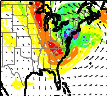
4 PSU WRF-EnKF ECMWF GFS 1//1 - z 1/7/1 - z 1//1 - z a b c d e f g h i Figure 1. Ensemble tracks (blue lines) for the PSU WRF-EnKF (first column), ECMWF (second column), and GFS (third column) forecasting systems for Hurricane Sandy initialized at (a c) UTC October 1, (d f) UTC 7 October 1, and (g i) UTC October 1. The three forecasting systems utilize, 5, and ensemble members, respectively. The NHC best track for Hurricane Sandy is overlaid in black, with positions marked every h and the deterministic runs are plotted in cyan. forecast is also successful, although a more noticeable northward track bias develops as the lead time decreases. The GFS forecasts at this lead time are similar to the 7 h forecasts with the landfall location of all the ensemble members located too far to the north, highlighting the inability of this model to capture the final northwestward turn that Sandy made toward the New Jersey coast. Overall, the track performance of the PSU WRF-EnKF, ECMWF, and GFS ensembles are above average and mostly successful, especially considering the unusual track of Hurricane Sandy. However, the overall structure of the track is better captured by the PSU WRF-EnKF and ECMWF systems, particularly the landfall location even at long lead times 3.. Uncertainty in Track and Intensity Forecasts by the PSU WRF-EnKF Ensemble Not only does the PSU WRF-EnKF forecast initialized at UTC October provide a sufficient deterministic forecast of the track and intensity of the cyclone, the diversity of the ensemble provides an opportunity to explore in detail what factors led to the divergence in track forecasts and therefore highlight the most influential fields in the model that determine the final position of Hurricane Sandy. Figure a shows the NHC best track and the tracks of the ensemble members of the PSU WRF-EnKF simulation at the 9 h lead time. The ensemble has been divided into composite groups according to the performance of the track forecasts. The composite group GOOD (POOR) consists of the 1 ensemble members with the lowest (highest) cumulative root-mean-square error (RMSE) in track compared to the best track. All of the remaining members make landfall and 1 of these whose cumulative RMSE s fall between that of GOOD and POOR MUNSELL AND ZHANG VC 13. American Geophysical Union. All Rights Reserved. 1
5 a b Minimum Sea Level Pressure (hpa) Minimum Sea Level Pressure (hpa) Forecast Hour c Forecast Hour d Wind Speed (kts) 5 Wind Speed (kts) Forecast Hour e Forecast Hour f Figure. Evolution of (a) the tracks (composite means in (b)), (c) the minimum SLP (hpa) (composite means in (d)), and (e) the maximum 1 m wind speeds (kt) (composite means in (f)) of the best track of Hurricane Sandy (black line with position marked every h in Figure a) and the ensemble members of the PSU WRF-EnKF forecast initialized at UTC October 1 grouped by track performance; GOOD the 1 members with the smallest cumulative track RMSE between the member and the best track (blue), FAIR the 1 members whose cumulative track RMSE fall between that of GOOD and POOR (magenta), and POOR the 1 members that do not landfall (red). A portion of the outermost domain in the WRF simulation is plotted in Figures a and b with sea surface temperature contours every 1 C. Numbers in Figure b indicate mean positions of each composite group at indicated forecast hour. became the composite group FAIR. Figure b shows the mean tracks of each composite group and clearly highlights the success of the track of GOOD compared to the best track, the northward and somewhat incorrect landfall location of FAIR, and the failure to predict a United States landfall in POOR. MUNSELL AND ZHANG VC 13. American Geophysical Union. All Rights Reserved.
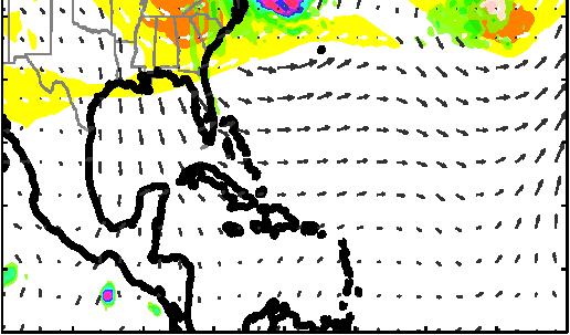
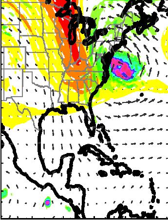
6 In addition to the ensemble track forecasts, the mean intensity evolution of the composite groups also compare favorably with the best track intensity. Figures c and e show the minimum SLP and maximum 1 m wind speed evolution for each ensemble member and the best track intensity until Forecast Hour 9, while Figures d and f show the means in intensity for the composite groups. The steady intensification of Sandy as landfall approaches is forecasted in all composite groups. Both GOOD and FAIR predict a slight overintensification, although this is most likely due to an intensity bias that is present in the PSU WRF-EnKF system. The intensity of POOR is the closest to the best track intensity, particularly in the latter half of the simulation, although this is a coincidence as POOR follows a completely different track than the best track and weakens in intensity due to the cooler SSTs that the members encounter. The maximum wind speeds are perhaps more representative of the intensity performance of this simulation, as the secondary intensification period of Sandy before landfall is somewhat captured in GOOD and FAIR, although not at the magnitude that is observed in the best track Comparisons of the Synoptic Environments of the Composite Groups In order to further explore what differences among the ensemble led to the divergence in tracks, an analysis of the overall synoptic environments is performed. Figure 3 shows composite plots for GOOD, FAIR, and POOR of km radar reflectivity, 5 hpa geopotential heights, and surface wind vectors for a portion of the outermost domain at Forecast Hour,,, and 9. At Forecast Hour (Figure 3, top), these surface maps reveal that there are no obvious differences among the initial conditions of the composite groups. Hurricane Sandy is located north of Cuba and just to the east of the coast of Florida, with the majority of the strongest convection located to the northeast of the circulation centers. In addition, a midtropospheric trough and frontal system of similar intensity is located across the Midwestern and Great Lakes regions of the United States in the three composites. Finally, a weaker low-pressure system is also located in the Northern Atlantic with once again no noticeable differences among the composite plots. At Forecast Hour (Figure 3, second row), Sandy has continued to move toward the northwest in GOOD, FAIR, and POOR, and the structure of Sandy has evolved into a more asymmetric storm with the majority of the convection now located to the north of the center. In all the composites, the frontal system has also continued eastward and has begun to impact the Mid-Atlantic region of the United States. Discernible distinctions between these composites are again difficult to identify, so plots of the differences between the composites are created to aid in the visualization (Figure ). The difference plots at Forecast Hour (Figure, top) confirm what was observed in the surface maps; there is virtually no difference between the locations of the frontal system, the low-pressure system in the North Atlantic and Hurricane Sandy. However, at Forecast Hour, both the GOOD-POOR and GOOD-FAIR difference plots reveal a displacement in the position of Hurricane Sandy that was not easily observable in the surface maps alone (Figure, second row). This shift in location is indicated by the displacement in the radar reflectivity fields and the differences in the geopotential height contours. This difference in the center position of Hurricane Sandy is not observed in the FAIR-POOR plot, indicating that at this time the FAIR and POOR ensemble members have not begun to separate from each other, and only the GOOD members have traveled further to the northwest and are therefore the closest to the United States coastline. This is consistent with the mean track of GOOD (Figure b), which first indicated this difference in position. It is interesting to note that at this forecast hour there are very few differences among the composites in the position of the front and the low-pressure system in the North Atlantic, indicating that the differences in tropical cyclone track between GOOD and FAIR at this time are dictated by the position of Hurricane Sandy itself. By Forecast Hour (Figure 3, third row), Sandy has made a turn toward the northeast in all three composites, with the areas of strongest convection now located to the north and northwest of the center. The frontal system has also progressed eastward and is nearing its interaction with Hurricane Sandy, particularly in GOOD and FAIR. The difference plots in Figure for this forecast hour (third row) reveal a clear separation in the location of Hurricane Sandy in all three composites. The FAIR-POOR plot demonstrates that the previously overlapping centers are now also displaced from each other. The geopotential height contours in particular indicate that the center of FAIR is now located to the north of the center of POOR. Therefore, in the time between Forecast Hour and, the members of FAIR have traveled to the northeast more quickly than the members of POOR. The GOOD-FAIR differences reveal that the centers of these composite groups are still displaced longitudinally, with the center of GOOD located to the west of the center of FAIR. If one combines the latitudinal displacement between FAIR and POOR with the longitudinal displacement MUNSELL AND ZHANG VC 13. American Geophysical Union. All Rights Reserved. 3
, 5 hpa geopotential heights (gray contour lines every 1 m), and 1 m winds (vectors) for the GOOD, FAIR, and")
7 Figure 3. Surface maps of composite km simulated radar reflectivity (filled contours every 5 dbz), 5 hpa geopotential heights (gray contour lines every 1 m), and 1 m winds (vectors) for the GOOD, FAIR, and POOR composite groups at Forecast Hour,,, and 9 for a portion of the outermost domain in the forecast system. The geopotential height contours and the surface wind vectors have been smoothed (using a 1::1 smoother in both the x and y directions) 1 times for clearer visualization. between GOOD and FAIR, the difference between GOOD and POOR should be in both directions. This is consistent with what is seen in Figure, as the vortex of GOOD is located to the northwest of the vortex of POOR. Once again, at this forecast hour the differences between the positions of Sandy are far greater than any differences between the front and the low-pressure system in the composites, indicating that the location of Sandy is the dominant factor that leads to the deviation in tracks. The surface maps for Forecast Hour 9 (Figure 3, bottom) clearly show the divergence in track for this ensemble. In the GOOD and FAIR composites, Sandy has turned back toward the northwest and landfall at the United States coastline is imminent in GOOD and is being approached in FAIR. The frontal system and Sandy have interacted and merged into one, with the strongest areas of convection located where this merge has taken place. Meanwhile, it is clear from the POOR composite that Sandy has continued its northeast trajectory and is turning even more toward the east as it begins to head out to sea. Given these noticeable differences in the surface plots, the GOOD-POOR and FAIR-POOR difference plots at this forecast hour (Figure, bottom) noticeably show a very large separation between the centers of the cyclones. The GOOD-FAIR composite MUNSELL AND ZHANG VC 13. American Geophysical Union. All Rights Reserved.
, 5 hpa geopotential height (contour lines every 1 m; light gray positive and dark gray negative), and surface winds (vectors)")
8 Figure. Differences between km radar reflectivity (filled contours every 5 dbz), 5 hpa geopotential height (contour lines every 1 m; light gray positive and dark gray negative), and surface winds (vectors) for the composite surface maps shown in Figure 3 GOOD-POOR (first column), GOOD-FAIR (second column), and FAIR-POOR (third column) for Forecast Hour,,, and 9. confirms that the longitudinal displacement between the centers of the GOOD and FAIR composite persists throughout the simulation, which leads to a difference in location and timing of the landfall of Sandy. It is clear from this analysis that differences in the location of Hurricane Sandy that develop throughout the first h of the simulation determine whether a given ensemble member will make landfall or not, in addition to controlling the accuracy of the landfall location and timing. Given this information, it is important to next identify and understand what causes the differences in the position of Hurricane Sandy in order to determine the most influential factors on the tracks of this ensemble. 3.. Causes of Ensemble Track Divergence: Differences in the Environmental Steering Flow The surface maps and difference plots analyzed above revealed a connection between the location of Hurricane Sandy during the first h of the simulation and the final location of Sandy. Since these differences in position are related to differences in translational speed among the ensemble (members of GOOD travel a greater distance to the northwest in the first h of the simulation than FAIR or POOR), it is useful to examine the differences in the environmental steering flow among the ensemble. Steering flow theory is often MUNSELL AND ZHANG VC 13. American Geophysical Union. All Rights Reserved. 5
9 Forecast Hour 1 Forecast Hour 1 Forecast Hour Meridional Zonal a b c Forecast Hour 3 Forecast Hour Forecast Hour d e f Figure 5. Vertical profiles of mean zonal (top row) and meridional (bottom row) winds (averaged over radii between km and 5 km from the surface center for each ensemble member) for the composite groups GOOD (blue), FAIR (magenta), and POOR (red), as well as the analysis of the ECMWF (black) and GFS (gray) at Forecast Hour (a) 1, (b) 1, (c), (d) 3, (e), and (f). used in forecasting to predict both direction and speed of the movement of a tropical cyclone. Typically, midtropospheric flow (7 hpa 5 hpa) averaged over an area of 5 7 degrees of latitude from the center of the TC is highly correlated with tropical cyclone movement [Chan and Gray, 19]. Figures 5a 5c show the height profiles of the mean zonal component of wind averaged between and 5 km from the TC center for the composite groups GOOD, FAIR, and POOR at Forecast Hours 1, 1, and. The profiles of the ECMWF and GFS analysis are also shown and are for the most part comparable to the wind profiles for the PSU WRF-EnKF ensemble. Profiles calculated by averaging the winds between a km and km radius and a 5 km to km radius from the TC center reveal slightly different wind magnitudes but the differences amongst the composite profiles are consistent with Figure 5 (not shown). At Forecast Hour 1, the GOOD profile is located to the left of the profiles for both FAIR and POOR. In the midtropospheric region (particularly between heights of km), the average zonal winds in GOOD are more negative than those in FAIR and POOR. This difference in zonal wind persists at Forecast Hour 1 and, although the magnitude of the winds in all profiles begin to decrease over time as the forward motion of Sandy slows in preparation for its turn toward the northeast. This stronger negative zonal wind corresponds to Sandy being embedded in stronger easterly winds in GOOD that increase the zonal motion of Sandy over the first h of the simulation. This difference in zonal motion leads to the displacement in the position of the vortices that influences the eventual landfall position of Sandy for a given member. Although the vertical profiles of zonal wind provide evidence toward differences in the steering flow of the composite groups contributing to the track divergence among the ensemble, it is difficult to visualize the precise direction of the steering flow vector by analyzing only one component of the wind at a time. In an ensemble sensitivity study on Super Typhoon Megi, Qian et al. [13] demonstrated that plotting the mean steering flow vector for subsets of an ensemble helped to explain the divergence in track. Therefore, Figure shows the evolution over the first h of the simulation of the mean steering flow vector for the 7 hpa to 5 hpa layer averaged between km and 5 km from the TC center for the various composite groups. Also calculated are the steering flow vectors for both the ECMWF and GFS forecasts. Initial differences in the magnitude and direction of the steering flow vector among the composites are difficult to identify, MUNSELL AND ZHANG VC 13. American Geophysical Union. All Rights Reserved.
10 Forecast Hour Forecast Hour Forecast Hour Forecast Hour 1 Forecast Hour Forecast Hour Forecast Hour 3 Forecast Hour Forecast Hour Figure. Evolution (every h between Forecast Hour and ) of the environmental steering flow vectors (winds averaged over radii between km and 5 km from the surface center and between the 7 hpa and 5 hpa vertical levels) for the composite groups GOOD (blue), FAIR (magenta), and POOR (red), as well as the ECMWF (black) and GFS (gray) forecasts initialized at UTC October 1. The steering flow vectors are oriented in the direction that the compass rose specifies and magnitudes are indicated by the length of the vectors (m/s). however, by Forecast Hour and 1 the magnitude of the GOOD steering flow vector is larger and the vector is oriented in a direction further west than the FAIR and POOR steering flow vectors. At Forecast Hour 1, the steering flow vectors of the composite groups have similar magnitudes, however, the direction of the GOOD vector is still oriented to the northwest, while the directions of both the FAIR and the POOR vector is oriented toward the northeast. This reveals that in the members composing both FAIR and POOR, Sandy has already turned toward the northeast and has begun to move away from the United States MUNSELL AND ZHANG VC 13. American Geophysical Union. All Rights Reserved. 7
11 coastline. This difference in both the magnitude and direction of the steering flow vector is consistent with the GOOD composite members traveling a further distance over the first h of the simulation, leading to a displacement in the location of the vortices from FAIR and POOR, which influences the final landfall location of Sandy. It is interesting to note that the evolution of the steering flow vectors and the subsequent differences in the performance of the track forecasts of Sandy for the operational models are also consistent with the PSU WRF-EnKF ensemble. Although initial differences in the operational steering flow vectors are not apparent, at Forecast Hour 1 the steering flow vector for the ECMWF forecast is stronger in magnitude and oriented further to the west than the vector associated with the GFS forecast. By Forecast Hour 1, the ECMWF steering flow vector is still directed toward the northwest, while the GFS steering flow has already turned toward the north. This difference in the magnitude and direction of the steering flow vectors is in agreement with the PSU WRF-EnKF ensemble, where the subsequent performance of the ECMWF forecasts is more aligned with the GOOD composite group and the GFS track forecasts are more consistent with the FAIR and POOR composites. This is an indication that differences between the steering flow in the ECMWF and GFS forecast runs may have contributed to the differences in track forecasts produced by these models. The differences in zonal wind and the steering flow vectors among the composite groups over the first h of the simulation help to explain the eventual divergence in track of GOOD from FAIR and POOR, however at this time the tracks of FAIR and POOR have not yet separated. Between Forecast Hour and though, the divergence in track is sufficient to cause FAIR to make landfall and POOR to head out to sea. Differences in translational motion among the members as Sandy moves predominantly to the northeast also lead to this track divergence. Figures 5d 5f show the height profiles of the mean meridional component of wind averaged between and 5 km from the TC center for the composite groups GOOD, FAIR, and POOR and the ECMWF and GFS analysis at Forecast Hours 3,, and. The wind profiles and steering flows are very similar at Forecast Hour 3, but by Forecast Hour the POOR profile has begun to separate from the other composite groups. Throughout nearly the entire profile, the magnitude of the composite meridional wind is smaller in POOR. This difference indicates that these composite members are traveling to the northeast at a slower translational speed due to weaker winds in the steering-flow layer. The steering flow vectors for these Forecast Hours (Figure ) confirm the conclusions drawn from the wind profiles. At Forecast Hours and 3, there are no discernible differences between the steering flow vectors of the composite groups. However, by Forecast Hours and the magnitude of the FAIR steering flow vector has increased, allowing Sandy to be steered further to the northeast over this time than the weaker steering flow vector that is associated with POOR. There is also a subtle difference in the direction of the FAIR and POOR steering flow vectors at these times, as the FAIR vector is oriented further to the north than the POOR vector, which contributes to the difference in the latitudinal location of the composite vortices of FAIR and POOR over the first h of the simulation. It is this difference in latitudinal position that leads to the track divergence between the composite groups FAIR and POOR Track Sensitivity and Uncertainty to the Initial Conditions: Tropical Versus Midlatitude Although the PSU WRF-EnKF simulation of Hurricane Sandy showed a clear divergence among the tracks of the ensemble that appeared to develop due to differences in the environmental steering flow over the first h of the simulation, it is worth investigating how sensitive the evolution of these members were to their initial conditions. It has already been shown in this ensemble, as well as in other similar TC ensemble simulations [Zhang and Sippel, 9; Sippel and Zhang, 1; Munsell et al., 13] that small and usually unobservable differences in initial conditions can lead to large spread in both track and intensity forecasts of tropical cyclones. In addition, studies such as Torn and Hakim [9] and McTaggart-Cowan et al.[1] have utilized sensitivity techniques on other case studies of tropical cyclones to determine the dominant factors in the initial conditions that contribute to divergent forecasts. In order to search for possible relationships between the tracks of Sandy in this ensemble and the initial conditions a set of sensitivity experiments was performed. All fields of the initial conditions for the 1 members comprising the groups GOOD, FAIR, and POOR were averaged together and the resulting composite initial conditions were utilized in an otherwise identical simulation to the original ensemble. The resulting tracks and intensities from these three sensitivity experiments (GOODCOMP, FAIRCOMP, POORCOMP) as well as the composite tracks and intensities of GOOD, FAIR, and POOR that were used in the above analysis are shown in MUNSELL AND ZHANG VC 13. American Geophysical Union. All Rights Reserved.
12 Minimum Sea Level Pressure (hpa) Wind Speed (kts) Forecast Hour Forecast Hour Figure 7. (a) Tracks, (b) minimum SLP (hpa), and (c) maximum 1 m wind speeds (kt) from the first sensitivity experiment (GOODCOMP thick blue, FAIRCOMP thick magenta, POORCOMP thick red) and the original composites (GOOD thin blue, FAIR thin magenta, POOR thin red). Best track information is also plotted in black. The sensitivity experiment results are plotted at hourly intervals while the original simulation is recorded at h intervals. a b c Figure 7. Other than the fact that the tracks and intensities have more variation in their evolution (due to hourly output being recorded rather than hourly output), the tracks, minimum SLP and maximum wind evolutions of GOODCOMP, FAIRCOMP, and POOR- COMP are very similar to the track and intensity evolution of GOOD, FAIR, and POOR. This provides evidence that although the initial conditions among the ensemble are very similar (Figure, first row), the initial conditions of a given ensemble member have a large influence on the final track and intensity of Sandy. The differences in steering flow that led to divergence in the location of the vortices of Sandy over the first h of the simulation therefore are determined by and develop from the initial conditions. The similarity in the results of this sensitivity experiment also suggests that the track forecast error growth is fairly linear with respect to uncertainties in the initial conditions. Given the conclusion that the divergence of the tracks in this ensemble appears to have been produced by differences in the location of the vortices of Sandy caused by variance in the environmental steering flow vectors, a new set of sensitivity experiments is performed where the initial conditions are altered to determine whether the main factors that determine the track of Sandy are associated with the region that Sandy is initially embedded in, or in the region containing the midlatitude frontal system. To show this, new initial conditions are created by combining portions of the initial conditions of GOODCOMP, FAIRCOMP, and POORCOMP together based on a latitudinal division between Sandy and the midlatitude system. Experiment MLPOOR_TCGOOD combines the southern portion of the GOODCOMP initial conditions, which contains Hurricane Sandy, with the northern portion of the POORCOMP initial conditions, which contains the midlatitude system. Two additional experiments that combine the initial conditions in the different regions are also performed; MLFAIR_TCGOOD uses the southern section of GOODCOMP and the northern section of FAIRCOMP, while MLGOOD_TCPOOR uses the southern section of POORCOMP with the northern section of GOODCOMP. In all three of these combinations of initial conditions, the tropical portion containing Sandy contains all points south of 3 N, the midlatitude portion consists of all points north of 35 N and between 3 N and 35 N a linear combination of the two original initial conditions is performed based on the MUNSELL AND ZHANG VC 13. American Geophysical Union. All Rights Reserved. 9
13 a b Figure. (a) Tracks from the second sensitivity experiment (MLGOOD_TCPOOR thick blue, MLFAIR_TCGOOD thick magenta, MLPOOR_TCGOOD thick red) and the original composites (GOOD thin blue, FAIR thin magenta, POOR thin red). The NHC Best Track (black) is also plotted. (b) Ensemble mean 5 hpa zonal wind (filled contours every 5 m/s) at Forecast Hour for the PSU WRF-EnKF simulation initialized at UTC October 1. Correlation contours between the distance from the Best Track landfall position and the 5 hpa zonal winds are also overlaid (1.3 in dark gray, 1.5 in magenta,.3 in light gray,.5 in white). distance away from these latitudinal boundaries. These initial conditions were then simulated under an otherwise identical set up to the original ensemble and the resulting tracks of Hurricane Sandy are given in Figure a. Over the first 3 h of the simulation, the MLGOOD_TCPOOR track turns toward the northeast without traveling as far of a distance as the other tracks and is therefore more similar to the POORCOMP track. The MLFAIR_TCGOOD and MLPOOR_TCGOOD simulations produce storms that do travel further to the northwest before turning to the northeast, much like the GOODCOMP track. As the simulation advances, the MLFAIR_TC- GOOD and MLPOOR_TCGOOD tracks diverge slightly as Sandy moves toward the northeast before curving back toward the northwest to make landfall. It is worth noting that the landfall position of MLFAIR_TCGOOD is very near the landfall position of GOODCOMP and the landfall location of MLPOOR_TCGOOD is at the same location as FAIRCOMP. Meanwhile, MLGOOD_TCPOOR closely follows the track of POORCOMP and heads out to sea. These simulations provide strong evidence that the portion of the domain containing Hurricane Sandy that is south of 3 N is the most influential in determining the final position of Hurricane Sandy. The simulations run with the initial conditions of the tropical region from GOODCOMP make landfall, while the simulation run using the POORCOMP tropical initial conditions heads out to sea. The midlatitude region is not irrelevant as MLFAIR_TCGOOD and MLPOOR_TCGOOD make landfall in different locations, with the MLFAIR_TCGOOD landfall position ultimately closer to the best track than the MLPOOR_TCGOOD landfall position. However, these results clearly illustrate that the impact that the midlatitude region and frontal system has on the landfall location of Sandy is secondary to the position of Sandy itself, which is controlled by the environmental steering flow in the surrounding area. This is consistent with what was shown above in the steering flow analysis. Next, the areas of the initial conditions fields (over the tropical region south of 3 N) that have the largest effect on the tracks of the ensemble members are explored in more detail. To do this, two-dimensional correlation contour fields between the location of Hurricane Sandy at landfall (calculated as the distance from the best track position at landfall) and the 5 hpa zonal winds are calculated and overlaid on the ensemble composite mean zonal winds at 5 hpa (Figure b). The mean zonal wind composite reveals a somewhat expected structure characterized by positive zonal winds to the south and negative zonal winds to the north of the center of Sandy, which is associated with the cyclonic circulation of a tropical cyclone. In addition, the midlevel zonal winds of the frontal system are positive and relatively strong as the system is moving toward the east, while the winds in the southern portion of the domain are weak easterlies associated with the trade winds. The correlation contours reveal a large swath of weak to moderate positive correlation between the final position of Sandy and the zonal winds, indicating that in this region there are stronger easterly winds in the MUNSELL AND ZHANG VC 13. American Geophysical Union. All Rights Reserved. 5
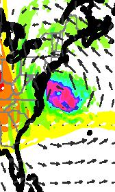
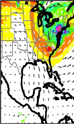
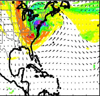
14 ensemble members that make landfall in the locations closest to the best track. The stronger midlevel easterlies in the more successful ensemble members steer the vortex of Sandy further to the northwest over the first day of the simulation, in agreement with the steering flow analysis presented above. In addition, there is another area of significant correlation located to the north of the composite center of Sandy that provides further evidence that the easterly background environmental steering flow of the ensemble members that eventually make landfall is stronger than the flow of the members that head out to sea. In summary, the divergence of tracks in this ensemble simulation is predominantly caused by differences in the initial environmental midlevel steering flow that Sandy is embedded in, which leads to a separation in the location of the vortices amongst the members that determines the final position. 3.. Impacts of Ensemble Track Divergence: Differences in Rainfall Distributions and Interactions With the Midlatitude System The divergence in track in the PSU WRF-EnKF ensemble simulation of Hurricane Sandy not only increases the difficulty in forecasting where the storm will make landfall, but the divergence also introduces additional uncertainty in other forecasts associated with a landfalling tropical cyclone such as cumulative rainfall and storm surge. It has been shown that predicting local maxima in rainfall distributions of tropical cyclones can be difficult due to how quickly the rainfall distribution can change during landfall, as contributions from the eyewall, inner and outer rain bands evolve [Villarini et al., 11]. These evolutions can develop from the presence of certain environmental conditions such as vertical wind shear, which can cause rainfall to organize in certain downshear quadrants of the storm and subsequently alter the rainfall distribution [Corbosiero and Molinari, ; Rogers et al., 3; Chen et al., ; Matyas, 1]. In addition, many landfalling tropical cyclones either have undergone or are in the process of an extratropical transition, which introduces more uncertainty in the distribution as rainfall typically aligns to the left of the center or right of the center as tropical cyclones interact with midlatitude troughs [Atallah et al., 7; Chen, 11]. Given the dependence of landfalling tropical cyclone rainfall distributions on track, divergence and high sensitivity in the tracks of this ensemble combined with the uncertainty involved in tropical cyclone rainfall prediction in general, yields a challenging rainfall distribution forecast. Figure 9 shows the cumulative rainfall forecasts for the composite groups GOOD, FAIR, and POOR for the time period between UTC October 1 and UTC 31 October 1. Also plotted are the National Weather Service s observed rainfall totals associated with Hurricane Sandy. An evident comparison can be made between the observed rainfall totals and the GOOD composite rainfall distribution, as the simulated rainfall totals are very similar in both location and magnitude to the observations. Even more remarkable is the ability of the PSU WRF-EnKF system to correctly forecast areas of localized heavy rainfall, such as the orographic intensification over the inland region in West Virginia and the maxima near the shores of Lake Erie and Lake Ontario. The rainfall associated with the FAIR composite is structured in a very similar way to the distribution of GOOD; however, the cumulative totals in the areas of significant rainfall are approximately 5% of the totals in GOOD. The rainfall totals in POOR are significantly lower and do not exceed 1 mm, as the only contribution to the rainfall distribution is from the midlatitude system as Sandy heads out to sea. Given the similarity in the spatial structure but differences in magnitude between the rainfall distributions of GOOD and FAIR, it is worth investigating from where the differences in total rainfall arise. It has been shown that particularly in synoptic situations where a midlatitude system is interacting with a tropical system, a potential vorticity (PV) approach can be utilized to better understand the underlying dynamics that is governing the interaction [Hoskins et al., 195; Morgan and Neilsen-Gammon, 199; Atallah and Bosart, 3]. Because Hurricane Sandy is a warm-core system, a maximum in PV is observed in the lower levels (5 hpa 7 hpa) with little PV in the upper troposphere, while the cold-core midlatitude system must have a maximum in PV in the upper troposphere ( hpa hpa). Therefore, the upper-level and lowerlevel PV can be plotted together (Figure 1) with the areas of upper-level PV clearly attributed to the midlatitude trough and the areas of lower-level PV associated with Sandy. The PV composites for GOOD and FAIR at Forecast Hour 7 are very comparable. In both composites, the low-level PV maximum (greater than. PVU) associated with Sandy is nearing the negatively tilted midlatitude trough, although an interaction between the two systems has not yet commenced. Although difficult to distinguish in these plots, one has to remember that the center of Hurricane Sandy in GOOD is actually closer to the coast and the midlatitude trough than the center of Sandy in FAIR. This difference in the position of Sandy becomes evident in the PV MUNSELL AND ZHANG VC 13. American Geophysical Union. All Rights Reserved. 51
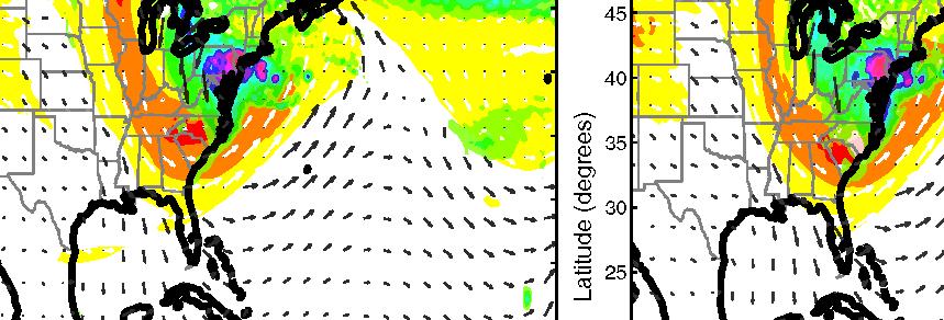
 associated with Hurricane Sandy according to (a) the National Weather Service observational network and the PSU WRF-EnKF, (b) GOOD, (c) FAIR, and (d) POOR")
15 a b c d Figure 9. Cumulative precipitation over land (in mm) associated with Hurricane Sandy according to (a) the National Weather Service observational network and the PSU WRF-EnKF, (b) GOOD, (c) FAIR, and (d) POOR composite forecasts. The NHC Best Track (black; position marked every h in Figure 9a and every h in Figures 9b 9d) and the PSU WRF-EnKF composite tracks (blue in Figure 9b, magenta in Figure 9c, and red in Figure 9d with positions marked every h) are also plotted. plots at Forecast Hour, as the TC is clearly interacting with the midlatitude trough in GOOD while the interaction in FAIR is only just beginning. Due to this interaction, a strong baroclinic zone exists and the PV associated with Sandy in GOOD is increasing. By Forecast Hour 9, Sandy is making landfall in the GOOD composite exactly when the interaction between Sandy and the midlatitude trough is at its strongest. The PV field associated with Sandy has not only intensified but also has increased in size, as the PV field associated with the midlatitude trough is somewhat weakened. Meanwhile, at Forecast Hour 9 in the FAIR composite, Sandy is still located off shore and is therefore at a larger distance away from the midlatitude trough, which appears to cause a lack of intensification in the PV field of Hurricane Sandy. Given these differences in the PV interactions between Sandy and the midlatitude trough, it is worth investigating how these differences in the timing and strength of the interaction contribute to the rainfall distributions associated with the composites. Figure 11 shows the accumulated rainfall over the previous h for the three forecast hours discussed above (7,, and 9) for the composite groups GOOD and FAIR. It is immediately apparent that in both composite groups the rainfall distribution of Sandy can be considered to be left of center, as there is very little rainfall located on the eastern half of the tropical cyclone. Although there are isolated areas of rainfall with higher amounts in FAIR, the distribution of rainfall in GOOD is more spread out and extends further westward into the Mid-Atlantic region of the United States. Because Hurricane Sandy is closer to making landfall at this time, it follows that more of this rainfall occurs over land rather than over the Atlantic Ocean. This interaction again highlights the importance of the position of Sandy in determining the subsequent rainfall magnitudes and distribution. Since there is a shift in the timing of landfall among the composites, where GOOD makes landfall at Forecast Hour 9 or approximately 1 h prior to landfall of FAIR (Forecast Hour 11), it is useful to compare the midlatitude and tropical system interactions among the composites in terms of number of hours prior to MUNSELL AND ZHANG VC 13. American Geophysical Union. All Rights Reserved. 5
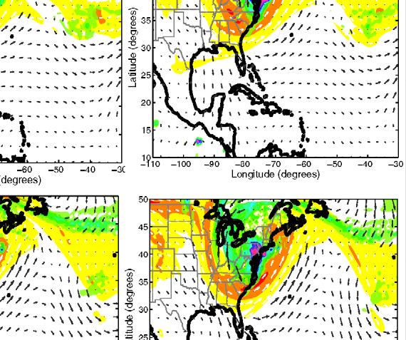
 potential vorticity (PV) composites for (top) GOOD and (bottom) FAIR at Forecast Hour (FH) (a and d) 7, (b and e), and (c and f) 9.")
16 Figure 1. Upper-level (averaged over the hpa to hpa layer; filled warm contours every PVU) and lower-level (averaged over the 5 hpa to 7 hpa layer; filled cool contours every. PVU) potential vorticity (PV) composites for (top) GOOD and (bottom) FAIR at Forecast Hour (FH) (a and d) 7, (b and e), and (c and f) 9. Upper-level winds (white vectors) and lower-level winds (black vectors) are also plotted. FH 7 FH FH 9 Fair Good a b c d e f Figure 11. Accumulated precipitation (in mm) over the h prior to Forecast Hour (FH) (a and d) 7, (b and e), and (c and f) 9 for the composite groups (top) GOOD and (bottom)fair. The NHC Best Track (black with positions marked every h) and composite tracks (blue GOOD, magenta FAIR with positions marked every h) are also plotted from the analyzed Forecast Hour until Sandy s dissipation/the end of the simulation. MUNSELL AND ZHANG VC 13. American Geophysical Union. All Rights Reserved. 53


17 TLF-1h TLF-h 5 1.1/13MS97 TLF-1h Good Journal of Advances in Modeling Earth Systems Fair Good TLF TLF-h TLF+h Fair Figure 1. As in Figure 1, but for, 1, 1, and h prior to landfall, at landfall, and h after landfall. and after landfall, rather than at a given Forecast Hour. This Lagrangian comparison more clearly demonstrates the importance of the timing of the midlatitude trough and Hurricane Sandy interaction on the composite rainfall distributions and in particular on the rainfall distributions over land. Figure 1 shows the MUNSELL AND ZHANG C 13. American Geophysical Union. All Rights Reserved. V 5
1. INTRODUCTION: 2. DATA AND METHODOLOGY:
 27th Conference on Hurricanes and Tropical Meteorology, 24-28 April 2006, Monterey, CA 3A.4 SUPERTYPHOON DALE (1996): A REMARKABLE STORM FROM BIRTH THROUGH EXTRATROPICAL TRANSITION TO EXPLOSIVE REINTENSIFICATION
Probabilistic Evaluation of Prediction and Dynamics of Super Typhoon MEGI (2010)
") Probabilistic Evaluation of Prediction and Dynamics of Super Typhoon MEGI (2010) 6 November 2012 Chuanhai Qian 1, Fuqing Zhang 2, Yihong Duan 1 1 China Meteorological Administration 2 Pennsylvania State
Probabilistic Evaluation of Prediction and Dynamics of Super Typhoon MEGI (2010) 6 November 2012 Chuanhai Qian 1, Fuqing Zhang 2, Yihong Duan 1 1 China Meteorological Administration 2 Pennsylvania State
(April 7, 2010, Wednesday) Tropical Storms & Hurricanes Part 2
 Tropical Storms & Hurricanes Part 2") Lecture #17 (April 7, 2010, Wednesday) Tropical Storms & Hurricanes Part 2 Hurricane Katrina August 2005 All tropical cyclone tracks (1945-2006). Hurricane Formation While moving westward, tropical disturbances
Lecture #17 (April 7, 2010, Wednesday) Tropical Storms & Hurricanes Part 2 Hurricane Katrina August 2005 All tropical cyclone tracks (1945-2006). Hurricane Formation While moving westward, tropical disturbances
Synoptic Meteorology II: Petterssen-Sutcliffe Development Theory Application March 2015
 Synoptic Meteorology II: Petterssen-Sutcliffe Development Theory Application 10-12 March 2015 In our lecture on Petterssen-Sutcliffe Development Theory, we outlined the principle of selfdevelopment in
10B.2 THE ROLE OF THE OCCLUSION PROCESS IN THE EXTRATROPICAL-TO-TROPICAL TRANSITION OF ATLANTIC HURRICANE KAREN
 10B.2 THE ROLE OF THE OCCLUSION PROCESS IN THE EXTRATROPICAL-TO-TROPICAL TRANSITION OF ATLANTIC HURRICANE KAREN Andrew L. Hulme* and Jonathan E. Martin University of Wisconsin-Madison, Madison, Wisconsin
Hurricanes. Hurricanes are large, tropical storm systems that form and develop over the warm waters near the equator.
 Hurricanes Hurricanes are large, tropical storm systems that form and develop over the warm waters near the equator. They are responsible for weather that can devastate entire communities: Heavy rain --
Chapter 24. Tropical Cyclones. Tropical Cyclone Classification 4/19/17
 Chapter 24 Tropical Cyclones Tropical Cyclones Most destructive storms on the planet Originate over tropical waters, but their paths often take them over land and into midlatitudes Names Hurricane (Atlantic
Early May Cut-off low and Mid-Atlantic rains
 Abstract: Early May Cut-off low and Mid-Atlantic rains By Richard H. Grumm National Weather Service State College, PA A deep 500 hpa cutoff developed in the southern Plains on 3 May 2013. It produced a
Chapter 24 Tropical Cyclones
 Chapter 24 Tropical Cyclones Tropical Weather Systems Tropical disturbance a cluster of thunderstorms about 250 to 600 km in diameter, originating in the tropics or sub-tropics Tropical depression a cluster
Tri-Agency Forecast Discussion for August 24, 2010
 Created 1600 UTC August 24, 2010 Tri-Agency Forecast Discussion for August 24, 2010 GRIP Forecast Team: Cerese Inglish, Matt Janiga, Andrew Martin, Dan Halperin, Jon Zawislak, Ellen Ramirez, Amber Reynolds,
ESCI 241 Meteorology Lesson 19 Tropical Cyclones Dr. DeCaria
 ESCI 241 Meteorology Lesson 19 Tropical Cyclones Dr. DeCaria READING: Chapter 16 GENERAL A tropical cyclone is a large, low-pressure system that forms over the tropical oceans. Tropical cyclones are classified
Tuesday, September 13, 16
 Weather Weather State Objectives 4.c, 4.d, 4.h. Discussion What are some ways in which weather affects your everyday life? Discussion What are some ways in which weather affects your everyday life? What
Heavy rains and precipitable water anomalies August 2010 By Richard H. Grumm And Jason Krekeler National Weather Service State College, PA 16803
 Heavy rains and precipitable water anomalies 17-19 August 2010 By Richard H. Grumm And Jason Krekeler National Weather Service State College, PA 16803 1. INTRODUCTION Heavy rain fell over the Gulf States,
Myung-Sook Park, Russell L. Elsberry and Michael M. Bell. Department of Meteorology, Naval Postgraduate School, Monterey, California, USA
 Latent heating rate profiles at different tropical cyclone stages during 2008 Tropical Cyclone Structure experiment: Comparison of ELDORA and TRMM PR retrievals Myung-Sook Park, Russell L. Elsberry and
The Impact of air-sea interaction on the extratropical transition of tropical cyclones
 The Impact of air-sea interaction on the extratropical transition of tropical cyclones Sarah Jones Institut für Meteorologie und Klimaforschung Universität Karlsruhe / Forschungszentrum Karlsruhe 1. Introduction
A Preliminary Climatology of Extratropical Transitions in the Southwest Indian Ocean
 A Preliminary Climatology of Extratropical Transitions in the Southwest Indian Ocean Kyle S. Griffin Department of Atmospheric and Environmental Sciences, University at Albany, State University of New
Examples of Pressure Gradient. Pressure Gradient Force. Chapter 7: Forces and Force Balances. Forces that Affect Atmospheric Motion 2/2/2015
 Chapter 7: Forces and Force Balances Forces that Affect Atmospheric Motion Fundamental force - Apparent force - Pressure gradient force Gravitational force Frictional force Centrifugal force Forces that
1C.4 TROPICAL CYCLONE TORNADOES: SYNOPTIC SCALE INFLUENCES AND FORECASTING APPLICATIONS
 1C.4 TROPICAL CYCLONE TORNADOES: SYNOPTIC SCALE INFLUENCES AND FORECASTING APPLICATIONS Daniel J. Cecil and Lori A. Schultz University of Alabama in Huntsville, Huntsville, AL, 35805 1. INTRODUCTION Several
Precipitation Structure and Processes of Typhoon Nari (2001): A Modeling Propsective
: A Modeling Propsective") Precipitation Structure and Processes of Typhoon Nari (2001): A Modeling Propsective Ming-Jen Yang Institute of Hydrological Sciences, National Central University 1. Introduction Typhoon Nari (2001) struck
Precipitation Structure and Processes of Typhoon Nari (2001): A Modeling Propsective Ming-Jen Yang Institute of Hydrological Sciences, National Central University 1. Introduction Typhoon Nari (2001) struck
Introduction to Meteorology & Climate. Climate & Earth System Science. Atmosphere Ocean Interactions. A: Structure of the Ocean.
 Climate & Earth System Science Introduction to Meteorology & Climate MAPH 10050 Peter Lynch Peter Lynch Meteorology & Climate Centre School of Mathematical Sciences University College Dublin Meteorology
2D.1 DETERMINATION OF A CONSISTENT TIME FOR THE EXTRATROPICAL TRANSITION OF TROPICAL CYCLONES
 2D.1 DETERMINATION OF A CONSISTENT TIME FOR THE EXTRATROPICAL TRANSITION OF TROPICAL CYCLONES David E. Kofron*, Elizabeth A. Ritchie, and J. Scott Tyo University of Arizona, Tucson, Arizona 1. INTRODUCTION
Hurricanes and Tropical Weather Systems:
 Hurricanes and Tropical Weather Systems: An influence on weather in parts of the USA Meteorology 411 Iowa State University Week 2 Bill Gallus Classification/Terminology Tropical Disturbance enhanced convection
Department of Atmospheric Sciences, National Taiwan University, Taipei, Taiwan
 10A.4 TROPICAL CYCLONE FORMATIONS IN THE SOUTH CHINA SEA CHENG-SHANG LEE 1 AND YUNG-LAN LIN* 1, 2 1 Department of Atmospheric Sciences, National Taiwan University, Taipei, Taiwan 2 Taipei Aeronautic Meteorological
Tropical-Extratropical Transition
 Tropical-Extratropical Transition Extratropical Transition A significant number of tropical cyclones move into the midlatitudes and transform into extratropical cyclones. This process is generally referred
Department of Meteorology, The Pennsylvania State University, University Park, Pennsylvania
 MARCH 2012 W E N G A N D Z H A N G 841 Assimilating Airborne Doppler Radar Observations with an Ensemble Kalman Filter for Convection-Permitting Hurricane Initialization and Prediction: Katrina (2005)
Synoptic Meteorology
 M.Sc. in Meteorology Synoptic Meteorology [MAPH P312] Prof Peter Lynch Second Semester, 2004 2005 Seminar Room Dept. of Maths. Physics, UCD, Belfield. Part 9 Extratropical Weather Systems These lectures
11A.3 The Impact on Tropical Cyclone Predictions of a Major Upgrade to the Met Office Global Model
 11A.3 The Impact on Tropical Cyclone Predictions of a Major Upgrade to the Met Office Global Model Julian T. Heming * Met Office, Exeter, UK 1. BACKGROUND TO MODEL UPGRADE The last major upgrade to the
Foundations of Earth Science, 6e Lutgens, Tarbuck, & Tasa
 Foundations of Earth Science, 6e Lutgens, Tarbuck, & Tasa Weather Patterns and Severe Weather Foundations, 6e - Chapter 14 Stan Hatfield Southwestern Illinois College Air masses Characteristics Large body
Atlantic Basin Satellite Image
 Tropical Update 11 AM EDT Friday, September 7, 2018 Tropical Depression Gordon, Tropical Storm Florence, Potential Tropical Cyclone #8 (90%), Invest 92L (90%) This update is intended for government and
Northeastern United States Snowstorm of 9 February 2017
 Northeastern United States Snowstorm of 9 February 2017 By Richard H. Grumm and Charles Ross National Weather Service State College, PA 1. Overview A strong shortwave produced a stripe of precipitation
Heavy Rainfall and Flooding of 23 July 2009 By Richard H. Grumm And Ron Holmes National Weather Service Office State College, PA 16803
 Heavy Rainfall and Flooding of 23 July 2009 By Richard H. Grumm And Ron Holmes National Weather Service Office State College, PA 16803 1. INTRODUCTION Heavy rains fall over Pennsylvania and eastern New
and 24 mm, hPa lapse rates between 3 and 4 K km 1, lifted index values
 3.2 Composite analysis 3.2.1 Pure gradient composites The composite initial NE report in the pure gradient northwest composite (N = 32) occurs where the mean sea level pressure (MSLP) gradient is strongest
PRMS WHITE PAPER 2014 NORTH ATLANTIC HURRICANE SEASON OUTLOOK. June RMS Event Response
 PRMS WHITE PAPER 2014 NORTH ATLANTIC HURRICANE SEASON OUTLOOK June 2014 - RMS Event Response 2014 SEASON OUTLOOK The 2013 North Atlantic hurricane season saw the fewest hurricanes in the Atlantic Basin
5 Atmospheric Disturbances 7 1.Cyclones- tropical and temperate and associated weather conditions. 2.Anticyclones and associated weather conditions.
 5 Atmospheric Disturbances 7 1.Cyclones- tropical and temperate and associated weather conditions. 2.Anticyclones and associated weather conditions. atmospheric disturbances (weather systems) that are
P1.14 THE SPATIAL PATTERNS OF RAINFALL PRODUCED BY HURRICANE IRENE (2011) AND OTHER TROPICAL CYCLONES WITH SIMILAR TRACKS
 AND OTHER TROPICAL CYCLONES WITH SIMILAR TRACKS") P1.14 THE SPATIAL PATTERNS OF RAINFALL PRODUCED BY HURRICANE IRENE (2011) AND OTHER TROPICAL CYCLONES WITH SIMILAR TRACKS Corene J. Matyas * University of Florida, Gainesville, Florida 1. INTRODUCTION
P1.14 THE SPATIAL PATTERNS OF RAINFALL PRODUCED BY HURRICANE IRENE (2011) AND OTHER TROPICAL CYCLONES WITH SIMILAR TRACKS Corene J. Matyas * University of Florida, Gainesville, Florida 1. INTRODUCTION
The Properties of Convective Clouds Over the Western Pacific and Their Relationship to the Environment of Tropical Cyclones
 The Properties of Convective Clouds Over the Western Pacific and Their Relationship to the Environment of Tropical Cyclones Principal Investigator: Dr. Zhaoxia Pu Department of Meteorology, University
4/29/2011. Mid-latitude cyclones form along a
 Chapter 10: Cyclones: East of the Rocky Mountain Extratropical Cyclones Environment prior to the development of the Cyclone Initial Development of the Extratropical Cyclone Early Weather Along the Fronts
AMERICAN METEOROLOGICAL SOCIETY
 AMERICAN METEOROLOGICAL SOCIETY Monthly Weather Review EARLY ONLINE RELEASE This is a preliminary PDF of the author-produced manuscript that has been peer-reviewed and accepted for publication. Since it
National Weather Service-Pennsylvania State University Weather Events
 National Weather Service-Pennsylvania State University Weather Events Heavy rainfall of 23 November 2011 by Richard H. Grumm National Weather Service State College PA 16803 Abstract:. A fast moving mid-tropospheric
5D.6 EASTERLY WAVE STRUCTURAL EVOLUTION OVER WEST AFRICA AND THE EAST ATLANTIC 1. INTRODUCTION 2. COMPOSITE GENERATION
 5D.6 EASTERLY WAVE STRUCTURAL EVOLUTION OVER WEST AFRICA AND THE EAST ATLANTIC Matthew A. Janiga* University at Albany, Albany, NY 1. INTRODUCTION African easterly waves (AEWs) are synoptic-scale disturbances
Tropical Waves. John Cangialosi and Lixion Avila National Hurricane Center. WMO Region IV Tropical Cyclone Workshop
 Tropical Waves John Cangialosi and Lixion Avila National Hurricane Center WMO Region IV Tropical Cyclone Workshop Outline Basic definition Schematic diagrams/interactions Operational products/forecasts
CHAPTER 8 NUMERICAL SIMULATIONS OF THE ITCZ OVER THE INDIAN OCEAN AND INDONESIA DURING A NORMAL YEAR AND DURING AN ENSO YEAR
 CHAPTER 8 NUMERICAL SIMULATIONS OF THE ITCZ OVER THE INDIAN OCEAN AND INDONESIA DURING A NORMAL YEAR AND DURING AN ENSO YEAR In this chapter, comparisons between the model-produced and analyzed streamlines,
2015 Hurricane Season Summary for Eastern Canada Impacts and Operational Notes
 2015 Hurricane Season Summary for Eastern Canada Impacts and Operational Notes John Parker Canadian Hurricane Centre, Meteorological Service of Canada April, 2016 Storms affecting Canadian territory in
Final Examination, MEA 443 Fall 2008, Lackmann
 Place an X here to count it double! Name: Final Examination, MEA 443 Fall 2008, Lackmann If you wish to have the final exam count double and replace your midterm score, place an X in the box above. As
Description of the ET of Super Typhoon Choi-Wan (2009) based on the YOTC-dataset
 based on the YOTC-dataset") High Impact Weather PANDOWAE Description of the ET of Super Typhoon Choi-Wan (2009) based on the YOTC-dataset ¹, D. Anwender¹, S. C. Jones2, J. Keller2, L. Scheck¹ 2 ¹Karlsruhe Institute of Technology,
High Impact Weather PANDOWAE Description of the ET of Super Typhoon Choi-Wan (2009) based on the YOTC-dataset ¹, D. Anwender¹, S. C. Jones2, J. Keller2, L. Scheck¹ 2 ¹Karlsruhe Institute of Technology,
Tropical Storm Hermine: Heavy rainfall in western Gulf By Richard H. Grumm National Weather Service Office State College, PA 16803
 Tropical Storm Hermine: Heavy rainfall in western Gulf By Richard H. Grumm National Weather Service Office State College, PA 16803 1. INTRODUCTION Tropical storm Hermine, the eighth named tropical system
The 2009 Hurricane Season Overview
 The 2009 Hurricane Season Overview Jae-Kyung Schemm Gerry Bell Climate Prediction Center NOAA/ NWS/ NCEP 1 Overview outline 1. Current status for the Atlantic, Eastern Pacific and Western Pacific basins
Tropical Cyclone Formation/Structure/Motion Studies
 Tropical Cyclone Formation/Structure/Motion Studies Patrick A. Harr Department of Meteorology Naval Postgraduate School Monterey, CA 93943-5114 phone: (831) 656-3787 fax: (831) 656-3061 email: paharr@nps.edu
Tropical Update. 5 PM EDT Tuesday, September 5, 2017 Hurricane Irma, Tropical Storm Jose, and Tropical Depression Thirteen
 Tropical Update 5 PM EDT Tuesday, September 5, 2017 Hurricane Irma, Tropical Storm Jose, and Tropical Depression Thirteen This update is intended for government and emergency response officials, and is
Tropical Update. 5 AM EDT Wednesday, September 6, 2017 Hurricane Irma, Tropical Storm Jose, and Tropical Storm Katia
 Tropical Update 5 AM EDT Wednesday, September 6, 2017 Hurricane Irma, Tropical Storm Jose, and Tropical Storm Katia This update is intended for government and emergency response officials, and is provided
Storm Summary for Hurricane Joaquin
 Storm Summary for Hurricane Joaquin Wednesday, September 30, 2015 at 5 PM EDT (Output from Hurrevac, based on National Hurricane Center Forecast Advisory #12) Joaquin is currently a Category 1 hurricane
Divergence, Spin, and Tilt. Convergence and Divergence. Midlatitude Cyclones. Large-Scale Setting
 Midlatitude Cyclones Equator-to-pole temperature gradient tilts pressure surfaces and produces westerly jets in midlatitudes Waves in the jet induce divergence and convergence aloft, leading to surface
David E. Kofron*, Miguel F. Piñeros, Elizabeth A. Ritchie, and J. Scott Tyo University of Arizona, Tucson, Arizona 1. INTRODUCTION
 15.4 DEFINING THE LIFECYCLE OF THE EXTRATROPICAL TRANSITION OF TROPICAL CYCLONES USING THE DEVIATION ANGLE VARIANCE TECHNIQUE FOR REMOTELY-SENSED IMAGERY David E. Kofron*, Miguel F. Piñeros, Elizabeth
Fronts in November 1998 Storm
 Fronts in November 1998 Storm Much of the significant weather observed in association with extratropical storms tends to be concentrated within narrow bands called frontal zones. Fronts in November 1998
What does a cloud-resolving model bring during an extratropical transition?
 What does a cloud-resolving model bring during an extratropical transition? Florian Pantillon (1) Jean-Pierre Chaboureau (1) Christine Lac (2) Patrick Mascart (1) (1) Laboratoire d'aérologie, Toulouse,
Mélicie Desflots* RSMAS, University of Miami, Miami, Florida
 15B.6 RAPID INTENSITY CHANGE IN HURRICANE LILI (2002) Mélicie Desflots* RSMAS, University of Miami, Miami, Florida 1. INTRODUCTION Rapid intensity change in tropical cyclones is one of the most difficult
2013 ATLANTIC HURRICANE SEASON OUTLOOK. June RMS Cat Response
 2013 ATLANTIC HURRICANE SEASON OUTLOOK June 2013 - RMS Cat Response Season Outlook At the start of the 2013 Atlantic hurricane season, which officially runs from June 1 to November 30, seasonal forecasts
608 SENSITIVITY OF TYPHOON PARMA TO VARIOUS WRF MODEL CONFIGURATIONS
 608 SENSITIVITY OF TYPHOON PARMA TO VARIOUS WRF MODEL CONFIGURATIONS Phillip L. Spencer * and Brent L. Shaw Weather Decision Technologies, Norman, OK, USA Bonifacio G. Pajuelas Philippine Atmospheric,
Multiscale Analyses of Inland Tropical Cyclone Midlatitude Jet Interactions: Camille (1969) and Danny (1997)
 and Danny (1997)") Multiscale Analyses of Inland Tropical Cyclone Midlatitude Jet Interactions: Camille (1969) and Danny (1997) Matthew Potter, Lance Bosart, and Daniel Keyser Department of Atmospheric and Environmental
Multiscale Analyses of Inland Tropical Cyclone Midlatitude Jet Interactions: Camille (1969) and Danny (1997) Matthew Potter, Lance Bosart, and Daniel Keyser Department of Atmospheric and Environmental
The Planetary Circulation System
 12 The Planetary Circulation System Learning Goals After studying this chapter, students should be able to: 1. describe and account for the global patterns of pressure, wind patterns and ocean currents
Predictability and Genesis of Hurricane Karl (2010) Examined through the EnKF Assimilation of Field Observations Collected during PREDICT
 Examined through the EnKF Assimilation of Field Observations Collected during PREDICT") 1260 J O U R N A L O F T H E A T M O S P H E R I C S C I E N C E S VOLUME 71 Predictability and Genesis of Hurricane Karl (2010) Examined through the EnKF Assimilation of Field Observations Collected during
1260 J O U R N A L O F T H E A T M O S P H E R I C S C I E N C E S VOLUME 71 Predictability and Genesis of Hurricane Karl (2010) Examined through the EnKF Assimilation of Field Observations Collected during
Hurricane Harvey the Name says it all. by Richard H. Grumm and Charles Ross National Weather Service office State College, PA
 Hurricane Harvey the Name says it all by Richard H. Grumm and Charles Ross National Weather Service office State College, PA 16803. 1. Overview Hurricane Harvey crossed the Texas coast (Fig. 1) as a category
Lower-Tropospheric Height Tendencies Associated with the Shearwise and Transverse Components of Quasigeostrophic Vertical Motion
 JULY 2007 N O T E S A N D C O R R E S P O N D E N C E 2803 Lower-Tropospheric Height Tendencies Associated with the Shearwise and Transverse Components of Quasigeostrophic Vertical Motion JONATHAN E. MARTIN
John Gyakum, Ron McTaggart-Cowan, Eyad Atallah, and Lance Bosart
 Hurricane Juan (2003): Forecasting and numerical simulation John Gyakum, Ron McTaggart-Cowan, Eyad Atallah, and Lance Bosart Outline Case Background Operational Forecasts and NWP Improved NWP Guidance
Victor Homar * and David J. Stensrud NOAA/NSSL, Norman, Oklahoma
 3.5 SENSITIVITIES OF AN INTENSE CYCLONE OVER THE WESTERN MEDITERRANEAN Victor Homar * and David J. Stensrud NOAA/NSSL, Norman, Oklahoma 1. INTRODUCTION The Mediterranean region is a very active cyclogenetic
Ensemble Prediction Systems
 Ensemble Prediction Systems Eric Blake National Hurricane Center 7 March 2017 Acknowledgements to Michael Brennan 1 Question 1 What are some current advantages of using single-model ensembles? A. Estimates
P Hurricane Danielle Tropical Cyclogenesis Forecasting Study Using the NCAR Advanced Research WRF Model
 P1.2 2004 Hurricane Danielle Tropical Cyclogenesis Forecasting Study Using the NCAR Advanced Research WRF Model Nelsie A. Ramos* and Gregory Jenkins Howard University, Washington, DC 1. INTRODUCTION Presently,
Synoptic Meteorology II: Frontogenesis Examples Figure 1
 Synoptic Meteorology II: Frontogenesis Examples The below images, taken from the 1200 UTC 17 January 2019 GFS forecast run, provide examples of the contributions of deformation and divergence to frontogenesis.
3. Midlatitude Storm Tracks and the North Atlantic Oscillation
 3. Midlatitude Storm Tracks and the North Atlantic Oscillation Copyright 2006 Emily Shuckburgh, University of Cambridge. Not to be quoted or reproduced without permission. EFS 3/1 Review of key results
Subtropical and Hybrid Systems IWTC VII Topic 1.6
 Subtropical and Hybrid Systems IWTC VII Topic 1.6 John R. Gyakum Department of Atmospheric and Oceanic Sciences McGill University, Montreal Canada Working group: John L. Beven II, Lance F. Bosart, Fermin
11/19/14. Chapter 11: Hurricanes. The Atmosphere: An Introduction to Meteorology, 12 th. Lutgens Tarbuck
 Chapter 11: Hurricanes The Atmosphere: An Introduction to Meteorology, 12 th Lutgens Tarbuck Lectures by: Heather Gallacher, Cleveland State University! Hurricanes: " Hurricanes are intense centers of
TOWARDS A BETTER UNDERSTANDING OF AND ABILITY TO FORECAST THE WIND FIELD EXPANSION DURING THE EXTRATROPICAL TRANSITION PROCESS
 P1.17 TOWARDS A BETTER UNDERSTANDING OF AND ABILITY TO FORECAST THE WIND FIELD EXPANSION DURING THE EXTRATROPICAL TRANSITION PROCESS Clark Evans* and Robert E. Hart Florida State University Department
11B.1 INFLUENCE OF DIABATIC POTENTIAL VORTICITY ANOMALIES UPON WARM CONVEYOR BELT FLOW. PART I: FEBRUARY 2003
 INFLUENCE OF DIABATIC POTENTIAL VORTICITY ANOMALIES UPON WARM CONVEYOR BELT FLOW. PART I: 14-15 FEBRUARY 2003 Philip N. Schumacher, NOAA/NWS, Sioux Falls, SD Joshua M. Boustead, NOAA/NWS, Valley, NE Martin
1. Which weather map symbol is associated with extremely low air pressure? A) B) C) D) 2. The diagram below represents a weather instrument.
 B) C) D) 2. The diagram below represents a weather instrument.") 1. Which weather map symbol is associated with extremely low air pressure? 2. The diagram below represents a weather instrument. Which weather variable was this instrument designed to measure? A) air pressure
1. Which weather map symbol is associated with extremely low air pressure? 2. The diagram below represents a weather instrument. Which weather variable was this instrument designed to measure? A) air pressure
Ch. 11: Hurricanes. Be able to. Define what hurricane is. Identify the life and death of a hurricane. Identify the ways we track hurricanes.
 Ch. 11: Hurricanes Be able to Define what hurricane is. Identify the life and death of a hurricane. Identify the ways we track hurricanes. What are Hurricanes? Smaller than mid-latitude cyclones. Don t
2D.4 THE STRUCTURE AND SENSITIVITY OF SINGULAR VECTORS ASSOCIATED WITH EXTRATROPICAL TRANSITION OF TROPICAL CYCLONES
 2D.4 THE STRUCTURE AND SENSITIVITY OF SINGULAR VECTORS ASSOCIATED WITH EXTRATROPICAL TRANSITION OF TROPICAL CYCLONES Simon T. Lang Karlsruhe Institute of Technology. INTRODUCTION During the extratropical
Features of the wind fields associated with Typhoon 0418 (Songda) compared with those of Typhoon 9119 (Mireille)
 compared with those of Typhoon 9119 (Mireille)") Features of the wind fields associated with Typhoon 0418 (Songda) compared with those of Typhoon 9119 (Mireille) by Fumiaki Fujibe 1, Naoko Kitabatake 2, Kotaro Bessho 2 and Shunsuke Hoshino 3 ABSTRACT
Features of the wind fields associated with Typhoon 0418 (Songda) compared with those of Typhoon 9119 (Mireille) by Fumiaki Fujibe 1, Naoko Kitabatake 2, Kotaro Bessho 2 and Shunsuke Hoshino 3 ABSTRACT
High Resolution Modeling of Multi-scale Cloud and Precipitation Systems Using a Cloud-Resolving Model
 Chapter 1 Atmospheric and Oceanic Simulation High Resolution Modeling of Multi-scale Cloud and Precipitation Systems Using a Cloud-Resolving Model Project Representative Kazuhisa Tsuboki Author Kazuhisa
PSU HFIP 2010 Summary: Performance of the ARW-EnKF Real-time Cloud-resolving TC Ensemble Analysis and Forecasting System.
 PSU HFIP 2010 Summary: Performance of the ARW-EnKF Real-time Cloud-resolving TC Ensemble Analysis and Forecasting System Fuqing Zhang Penn State University Contributors: Yonghui Weng, John Gamache and
Tropical Update. 5 AM EDT Monday, October 8, 2018 Tropical Storm Michael, Tropical Storm Leslie, Invest 92L (10%) & African Tropical Wave (50%)
 & African Tropical Wave (50%)") Tropical Update 5 AM EDT Monday, October 8, 2018 Tropical Storm Michael, Tropical Storm Leslie, Invest 92L (10%) & African Tropical Wave (50%) This update is intended for government and emergency response
Tropical Update 5 AM EDT Monday, October 8, 2018 Tropical Storm Michael, Tropical Storm Leslie, Invest 92L (10%) & African Tropical Wave (50%) This update is intended for government and emergency response
THE IMPACT OF SATELLITE-DERIVED WINDS ON GFDL HURRICANE MODEL FORECASTS
 THE IMPACT OF SATELLITE-DERIVED WINDS ON GFDL HURRICANE MODEL FORECASTS Brian J. Soden 1 and Christopher S. Velden 2 1) Geophysical Fluid Dynamics Laboratory National Oceanic and Atmospheric Administration
Tropical Cyclone Intensity and Structure Changes in relation to Tropical Cyclone Outflow
 DISTRIBUTION STATEMENT A. Approved for public release; distribution is unlimited. Tropical Cyclone Intensity and Structure Changes in relation to Tropical Cyclone Outflow Patrick A. Harr Department of
Lectures on Tropical Cyclones
 Lectures on Tropical Cyclones Chapter 1 Observations of Tropical Cyclones Outline of course Introduction, Observed Structure Dynamics of Mature Tropical Cyclones Equations of motion Primary circulation
LECTURE #18: Hurricane Damage, Monitoring & Case Study
 GEOL 0820 Ramsey Natural Disasters Spring, 2018 LECTURE #18: Hurricane Damage, Monitoring & Case Study Date: 27 March 2018 I. Exam II grades now posted online o high: 98, low: 46, average: 80 (~3 points
An upper to mid level circulation (Low) in the NW Caribbean is
 in the NW Caribbean is") WEEKLY WEATHER OUTLOOK BELIZE, CENTRAL AMERICA PERIOD: Monday-Monday, Oct. 1 October 8, 2012 DATE ISSUED: Monday, Oct 1, 2012 6:00 am RFrutos EcoSolutions & Services SYNOPSIS: An upper to mid level circulation
WEEKLY WEATHER OUTLOOK BELIZE, CENTRAL AMERICA PERIOD: Monday-Monday, Oct. 1 October 8, 2012 DATE ISSUED: Monday, Oct 1, 2012 6:00 am RFrutos EcoSolutions & Services SYNOPSIS: An upper to mid level circulation
Heavy Rainfall Event of June 2013
 Heavy Rainfall Event of 10-11 June 2013 By Richard H. Grumm National Weather Service State College, PA 1. Overview A 500 hpa short-wave moved over the eastern United States (Fig. 1) brought a surge of
TROPICAL CYCLONE REPORT
 TROPICAL CYCLONE REPORT Written by: Dávid Hérincs Tropical Storm Otilie 20-23 September 2018 Otilie (own-named) was a weak tropical storm that formed over the Tyrrhenian Sea. The cyclone was unique because
Typhoon Relocation in CWB WRF
 Typhoon Relocation in CWB WRF L.-F. Hsiao 1, C.-S. Liou 2, Y.-R. Guo 3, D.-S. Chen 1, T.-C. Yeh 1, K.-N. Huang 1, and C. -T. Terng 1 1 Central Weather Bureau, Taiwan 2 Naval Research Laboratory, Monterey,
Tropical Update. 5 PM EDT Sunday, October 7, 2018 Tropical Storm Michael, Tropical Storm Leslie, & Invest 92L (30%)
") Tropical Update 5 PM EDT Sunday, October 7, 2018 Tropical Storm Michael, Tropical Storm Leslie, & Invest 92L (30%) This update is intended for government and emergency response officials, and is provided
Tropical Update 5 PM EDT Sunday, October 7, 2018 Tropical Storm Michael, Tropical Storm Leslie, & Invest 92L (30%) This update is intended for government and emergency response officials, and is provided
Why the Atlantic was surprisingly quiet in 2013
 1 Why the Atlantic was surprisingly quiet in 2013 by William Gray and Phil Klotzbach Preliminary Draft - March 2014 (Final draft by early June) ABSTRACT This paper discusses the causes of the unusual dearth
Recent advances in Tropical Cyclone prediction using ensembles
 Recent advances in Tropical Cyclone prediction using ensembles Richard Swinbank, with thanks to Many colleagues in Met Office, GIFS-TIGGE WG & others HC-35 meeting, Curacao, April 2013 Recent advances
Nerushev A.F., Barkhatov A.E. Research and Production Association "Typhoon" 4 Pobedy Street, , Obninsk, Kaluga Region, Russia.
 DETERMINATION OF ATMOSPHERIC CHARACTERISTICS IN THE ZONE OF ACTION OF EXTRA-TROPICAL CYCLONE XYNTHIA (FEBRUARY 2010) INFERRED FROM SATELLITE MEASUREMENT DATA Nerushev A.F., Barkhatov A.E. Research and
USING GIS TO ASSESS THE SYMMETRY OF TROPICAL CYCLONE RAIN SHIELDS. Corene J. Matyas University of Florida PO Box , Gainesville, FL 32611
 Papers of the Applied Geography Conferences (2006) 29: 31-39 USING GIS TO ASSESS THE SYMMETRY OF TROPICAL CYCLONE RAIN SHIELDS Corene J. Matyas University of Florida PO Box 117315, Gainesville, FL 32611
16D.4 Evaluating HWRF Forecasts of Tropical Cyclone Intensity and Structure in the North Atlantic Basin
 16D.4 Evaluating HWRF Forecasts of Tropical Cyclone Intensity and Structure in the North Atlantic Basin Dany Tran* and Sen Chiao Meteorology and Climate Science San Jose State University, San Jose, California
Intraseasonal Variability and TC Forecasting
 Intraseasonal Variability and TC Forecasting 2017 WMO Class Eric Blake Hurricane Specialist National Hurricane Center 3/1/2017 Outline Madden-Julian Oscillation (MJO) MJO analysis tools Kelvin Waves Brief
Tropical Cyclone Hyperactivity in the Eastern and Central Caribbean Sea During the 2005 Atlantic Hurricane Season
 Proceedings of the National Conference On Undergraduate Research (NCUR) 2006 The University of North Carolina at Asheville Asheville, North Carolina April 6 8, 2006 Tropical Cyclone Hyperactivity in the
Satellites, Weather and Climate Module??: Polar Vortex
 Satellites, Weather and Climate Module??: Polar Vortex SWAC Jan 2014 AKA Circumpolar Vortex Science or Hype? Will there be one this year? Today s objectives Pre and Post exams What is the Polar Vortex
Impact of Assimilating Airborne Doppler Radar Velocity Data Using the ARPS 3DVAR on the Analysis and Prediction of Hurricane Ike (2008)
") 1 2 3 4 5 6 7 8 9 10 11 12 13 14 15 16 17 18 19 20 21 22 23 24 25 26 27 28 29 30 31 32 33 34 35 36 37 38 Impact of Assimilating Airborne Doppler Radar Velocity Data Using the ARPS 3DVAR on the Analysis
1 2 3 4 5 6 7 8 9 10 11 12 13 14 15 16 17 18 19 20 21 22 23 24 25 26 27 28 29 30 31 32 33 34 35 36 37 38 Impact of Assimilating Airborne Doppler Radar Velocity Data Using the ARPS 3DVAR on the Analysis
Lec 10: Interpreting Weather Maps
 Lec 10: Interpreting Weather Maps Case Study: October 2011 Nor easter FIU MET 3502 Synoptic Hurricane Forecasts Genesis: on large scale weather maps or satellite images, look for tropical waves (Africa
GC Briefing. Weather Sentinel Tropical Storm Michael. Status at 8 AM EDT (12 UTC) Today (NHC) Discussion. October 11, 2018
 Today (NHC) Discussion. October 11, 2018") GC Briefing Weather Sentinel Tropical Storm Michael October 11, 2018 After making landfall as a high-end category-4 hurricane on the Florida Panhandle, Michael weakened to tropical storm status early this
GC Briefing Weather Sentinel Tropical Storm Michael October 11, 2018 After making landfall as a high-end category-4 hurricane on the Florida Panhandle, Michael weakened to tropical storm status early this