Intraseasonal Variability and TC Forecasting
|
|
|
- Charlotte Thomas
- 5 years ago
- Views:
Transcription


1 Intraseasonal Variability and TC Forecasting 2017 WMO Class Eric Blake Hurricane Specialist National Hurricane Center 3/1/2017
2 Outline Madden-Julian Oscillation (MJO) MJO analysis tools Kelvin Waves Brief exercises
3 Question 1 What s the 3 rd busiest month on average in terms of Atlantic ACE? A. July B. August C. September D. October

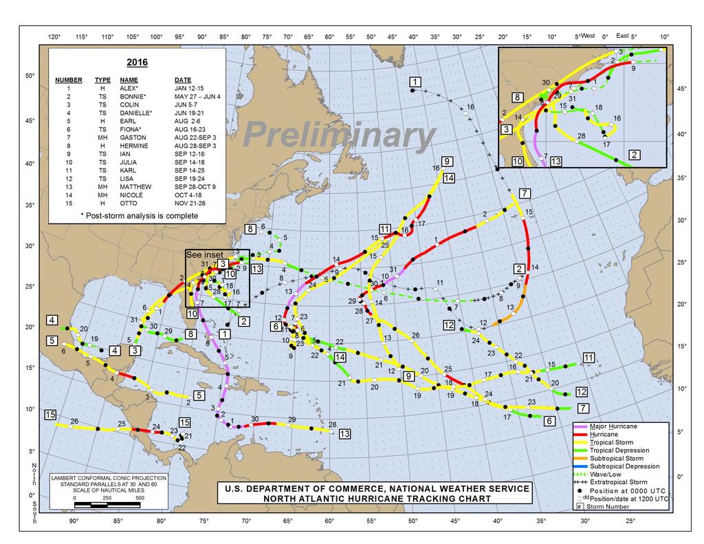
4 No Storm Formations in 2008
5
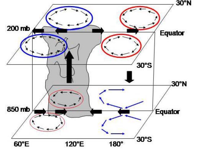
6 Madden-Julian Oscillation Discovered in the early 1970s by Roland Madden and Paul Julian. An eastward propagating wave that circles the globe in about days involving tropical convection. Detected in the Outgoing Longwave Radiation (OLR) and wind fields across the tropics. Later papers showed that it is an important modulator of TC activity, especially in the Pacific Ocean.
7 -Idealized Diagram of the day Tropical Intraseasonal Oscillation -Became known as the Madden-Julian Oscillation in the late 1980s -Generally forms over the Indian Ocean, strengthens over the Pacific Ocean and weakens due to interaction with South America and cooler eastern Pacific SSTs (Madden and Julian 1972)
8

9 Daily Rainfall (mm)
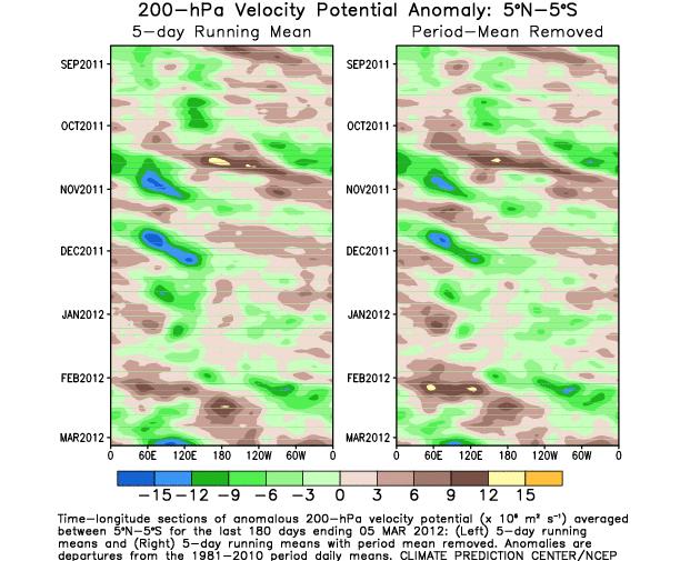
10 200 mb Velocity Potential fields one way to track the MJO Blue= ~divergence Red= ~convergence Center of the blue area tracks the most upper divergence, which is usually well-linked to thunderstorms
11

12 Most genesis points are near or behind the upperlevel divergence center.
 contours corresponding to regions in which convection tends to be enhanced (suppressed). http://www.")
13 Another way to track the MJO Animation of daily IR and 200-hPa velocity potential anomalies (base period ). Velocity potential anomalies are proportional to divergence with green (brown) contours corresponding to regions in which convection tends to be enhanced (suppressed).
14 10-day ECMWF MJO Forecast
 In western hemisphere, upper-level signal usually much easier to track than")
15 MJO characteristics Note signal is much stronger in eastern Hemisphere than western Eastward phase speed is a lot slower in eastern than western Hemi (convective coupling) In western hemisphere, upper-level signal usually much easier to track than lower-level
16 MJO Effects in the Atlantic Basin The MJO can lose much of its strength before entering the Atlantic basin. In addition, the MJO is weakest during the late summer, near the peak of Atlantic activity. Western part of the basin most strongly affected (Maloney and Hartmann 2000).

 Inactive MJO EOF and corresponding TS")


17 Active MJO EOF and corresponding TS and H tracks Active MJO in the western Caribbean Sea and Gulf of Mexico produces more storms due to: Increase in low-level convergence (ITCZ moves farther north) Inactive MJO EOF and corresponding TS and H tracks Low-level vorticity is also increased due to westerly low-level flow meeting easterly trades Upper divergence is stronger than average during the westerly phase, with a drop in shear as well Adapted from Maloney and Hartmann (2000)
18 A different way to visualize the MJO The axes (RMM1 and RMM2) represent daily values of the principal components from the two leading modes, following the active convection. The triangular areas indicate the location of the enhanced phase of the MJO Counter-clockwise motion is indicative of eastward propagation Distance from the origin is proportional to MJO strength Line colors distinguish different months

19 Current MJO: Plan view versus RMM diagram

20 200 mb Velocity Potential fields one way to track the MJO Blue= ~divergence Red= ~convergence Center of the blue area tracks the most upper divergence, which is usually well-linked to thunderstorms
21 Question 2 What phases of the MJO are most favorable for Atlantic TC activity? A. Phases 3/4 B. Phases 5/6 C. Phases 7/8 D. Phases 1/2
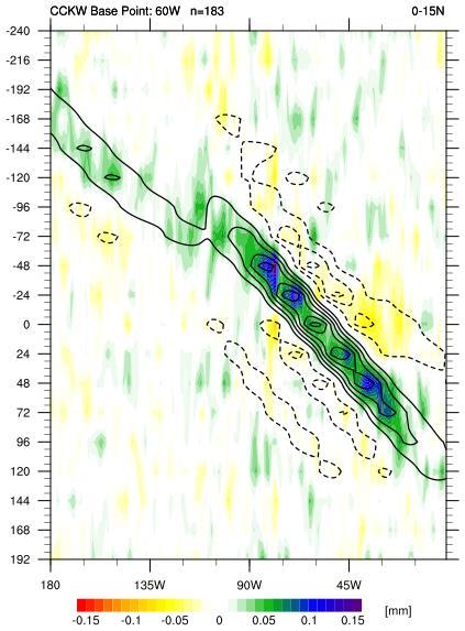
22 Normalized Activity by MJO Phase ( ) MJO Phase NS NSD H HD MH MHD ACE Phase Phase Phase Phase Phase Phase Phase Phase Ratio of Phases 1+2 to Phases From Klotzbach (2010)


23 850-hPa Vector Wind Anomalies (m s-1) Note that shading denotes the zonal wind anomaly Blue shades: Easterly anomalies Red shades: Westerly anomalies Typical Active Atlantic pattern (if in summer-time)!
24 All Genesis Points MJO Phases 1+2 MJO Phases 6+7
25 36 Major Hurricanes 13 Major Hurricanes

26 10 Hurricane Landfalls 1 Hurricane Landfall MJO Phase 2 MJO Phase 7


 &")
27 Kelvin Waves & Tropical Cyclones Adapted from: Michael Ventrice (TWC), Kyle Griffin (UW) & Carl Schreck (NCICS)
28 Background The idea of equatorial waves interacting with TCs is relatively new - An objective method of tracking equatorial waves in real-time wasn t published until First AMS papers mentioning (atmospheric) equatorial waves and TCs appeared around Number of papers that involve this or similar topics in AMS journals only number in the ~2 dozen range Equatorial waves aid in enhanced predictability of TC genesis several (3-7) days into the future.


29 Kelvin Waves Convergence Divergence Negative OLR Positive OLR Matsuno (1966) Alternating westerlies and easterlies on the equator Enhanced convection where low-level winds converge Active phase associated with latent heating & the generation of low-level relative vorticity due to presence of meridional flow NASA PMM Science Meeting October 2016, Houston, TX NASA PMM Grant NNX13AH47G Kiladis et al. (2009) Propagation: Eastward Phase speed: m s 1 Period: Wavelength: 3 10 days km Adapted from Carl Schreck
30 MJO vs. KW The Madden-Julian Oscillation (MJO) consists of an active and suppressed phase, dominated by low-level westerly and easterly anomalies, respectively. Convection is preferred in the active phase. A typical MJO moves eastward at 4 to 8 m s -1 with a zonal extent that spans planetary to synoptic scales. A Kelvin wave is spatially very similar to the MJO, but is typically observed at higher zonal wavenumbers and moves eastward at m s -1. Effects are more constrained within the Tropics and associated wind anomalies are spatially smaller than the MJO. Adapted from Griffin (2014)

31 Conceptual Model of Vertical Structure Low OLR Stratiform Deep Shallow 150 mb Dry Low Moist Warm High Dry 300 mb Cool 500 mb Moist Warm 700 mb High Low 1000 mb West East Straub and Kiladis (2003)
32 CCKW composites Performed using a base point of 60 W Averaged dates when CCKW-filtered TRMM rainfall reached minimum and was above +1 sigma. Relationships generally hold true for various base points across the Atlantic and Eastern Pacific, as well as the Eastern Hemisphere For Atlantic, most results smear after +/- 4-5 days Due to higher variability in phase speed of CCKW over Western Hemisphere
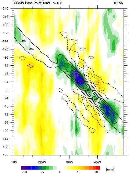
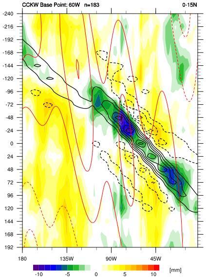
33 CCKW composites OLR TRMM rainfall
 Background Vertical Horizontal Summary NASA PMM Science Meeting October 2016, Houston, TX NASA PMM Grant")
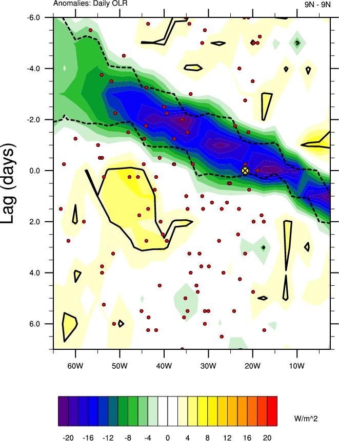
34 Kelvin Waves and Tropical Cyclogenesis Storms typically form 0 3 days after the Kelvin wave s convective peak Often interacting with MJO and Easterly Waves during genesis Easterly wave initiates or amplifies in the Kelvin wave convective envelope Schreck (2015, MWR) Background Vertical Horizontal Summary NASA PMM Science Meeting October 2016, Houston, TX NASA PMM Grant NNX13AH47G 34

35 Tropical wave + CCKW composite East Pacific: 40 storms Storm-relative Totals Composite Hovmöllers of storms forming at the most favorable lags (2-3d) from Kelvin wave crest The wave is invigorated with convection/rainfall, leading to genesis. CCKW most effective when some westerly flow already present NASA PMM Science Meeting October 2016, Houston, TX NASA PMM Grant NNX13AH47G 35


36 Vertical Structure East Pacific Zonal Wind Eq 10 N Convection and storm-relative westerlies intersect easterly wave 2 days before genesis Easterly wave circulation builds upward as the Kelvin wave propagates Kelvin tilt might explain lag in genesis from convection 400-hPa is 30 longitude behind 850- hpa Kelvin speed of 15 m s 1 gives a 2.5-day lag between 850 hpa and 400 hpa NASA PMM Science Meeting October 2016, Houston, TX NASA PMM Grant NNX13AH47G 36

37 Storm-Relative Zonal Winds Broad, persistent 850-hPa Westerlies 400-hPa westerlies develop with Kelvin wave Kelvin rain (green/orange) Kelvin u (red/blue) 2 Days before Genesis Kelvin wave enhances 850-hPa westerlies and rain Kelvin easterlies at 400-hPa counter Easterly wave At Genesis: Kelvin wave no longer effects 850-hPa winds or rainfall At 400-hPa, Kelvin wave helps close circulation Background Vertical Horizontal Summary NASA PMM Science Meeting October 2016, Houston, TX NASA PMM Grant NNX13AH47G 37
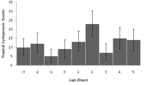
38 Atlantic CCKW genesis composites t -t Tropical cyclogenesis events over the MDR (5-25 N, W) relative to the CCKW during June-September Day 0 highlights the transition to statistically significant negative unfiltered OLR anomalies, or the eastern-most side of the convectively active phase of the CCKW. Error bars indicate the 95% confidence interval.

39 Tropical cyclogenesis relative to the Kelvin wave
40 TCs forming Epac TC formations within active MJO east of 120W CCKW enhanced CCKW suppressed Days from CCKW passage Kelvin Waves help focus the day of genesis within an active MJO 40
41 Extremely strong (4 SD) CCKW approaching an active tropical cyclone What happens? 41

42 Extremely strong (4 SD) CCKW approaching an active tropical cyclone What happens? Odile rapidly intensifies into a Category 4 hurricane 42

43 # of TCs forming 8 Hurricane formations within active MJO East of 120W CCKW enhanced CCKW suppressed Days after CCKW passes 43
44 10-day ECMWF forecast of CCKWs
45 10-day ECMWF forecast of eastwardmoving waves
46 Exercises

47 June 29 CFS Forecast: Strong MJO headed into the western Hemisphere with an El Nino base state. Expectations for July TCs?

48 All things being equal, describe the genesis potential over the next 3 days of a disturbance centered at the magenta dot.

49 Yet another strong CCKW is moving across the eastern Pacific This system should move through the eastern Pacific within the next few days, with genesis possible in the far eastern Pacific Days 3-5. Ana & Trudy form 49

50 Ana Trudy 50

51 Question 3 Global models forecast which type of wave the best? A. Tropical Wave B. MJO C. Kelvin Wave D. Gravity
52 Operational challenges Real-world CCKWs have day-to-day weather patterns overlaid on them, making them harder to recognize. When making genesis forecasts for a particular system, any CCKW information must be taken in context with the entire weather situation. Knowledge about the base state (~120 d mean or ENSO), MJO phase, climatology and numerical weather models must all be considered in concert with CCKW interactions. For example, if the base state is extremely unfavorable, can it overcome other enhancing factors? (e.g. most of the 2014 Atlantic hurricane season, 2015 EPac is the counter example) 52
53 Current NHC practices No operational standard on use of CCKW in genesis forecasts (about half of forecasters use it), not used at all for intensity forecasts. It is believed that global models handle the MJO much more accurately than individual CCKWs (too much dampening), and thus the forecaster can add value to the deterministic models. Any adjustments to 5-day genesis probabilities are small and subjectively determined. Also used as a way to increase forecaster confidence in a given situation if conceptual model of CCKWs and genesis matches model solutions. 53
54 Operational long-range TC forecasts CPC, in combination with other NOAA/federal/university partners, issues a week 1 and week 2 possible TC risk areas (in addition to other global hazards) These global forecasts are released Tuesday afternoons The TC-only forecasts are updated on Friday afternoons, if necessary, for the Atlantic/E Pacific only during week 1/2 54
55 Matthew x
56 Future Questions/Work How does the strength of the CCKW significantly affect the chance of TC genesis? Need a more objective way to attribute CCKWs to tropical cyclogenesis. A one-size-fits-all approach is not applicable with these waves due to various triggering mechanisms. Can a better TC-CCKW relationship be teased out of the data if one could more effectively remove the base state? How do you properly attribute TC intensity change to a CCKW? 56
Intraseasonal TC Variability and Seasonal Hurricane Forecasting
 Intraseasonal TC Variability and Seasonal Hurricane Forecasting 2018 WMO Class Eric Blake Hurricane Specialist National Hurricane Center 2/28/2018 Outline Madden-Julian Oscillation (MJO) MJO analysis tools
What is the Madden-Julian Oscillation (MJO)?
?") What is the Madden-Julian Oscillation (MJO)? Planetary scale, 30 90 day oscillation in zonal wind, precipitation, surface pressure, humidity, etc., that propagates slowly eastward Wavelength = 12,000 20,000
What is the Madden-Julian Oscillation (MJO)? Planetary scale, 30 90 day oscillation in zonal wind, precipitation, surface pressure, humidity, etc., that propagates slowly eastward Wavelength = 12,000 20,000
Variability of West African Weather Systems. Chris Thorncroft Department of Atmospheric and Environmental Sciences University at Albany
 Variability of West African Weather Systems Chris Thorncroft Department of Atmospheric and Environmental Sciences University at Albany Variability of West African Weather Systems (1) Convectively Coupled
COLORADO STATE UNIVERSITY FORECAST OF ATLANTIC HURRICANE ACTIVITY FROM AUGUST 18-31, 2017
 COLORADO STATE UNIVERSITY FORECAST OF ATLANTIC HURRICANE ACTIVITY FROM AUGUST 18-31, 2017 We expect that the next two weeks will be characterized by above-average amounts (>130%) of activity relative to
ENSO Cycle: Recent Evolution, Current Status and Predictions. Update prepared by Climate Prediction Center / NCEP 5 August 2013
 ENSO Cycle: Recent Evolution, Current Status and Predictions Update prepared by Climate Prediction Center / NCEP 5 August 2013 Outline Overview Recent Evolution and Current Conditions Oceanic Niño Index
ENSO Cycle: Recent Evolution, Current Status and Predictions. Update prepared by Climate Prediction Center / NCEP 23 April 2012
 ENSO Cycle: Recent Evolution, Current Status and Predictions Update prepared by Climate Prediction Center / NCEP 23 April 2012 Outline Overview Recent Evolution and Current Conditions Oceanic Niño Index
The 2009 Hurricane Season Overview
 The 2009 Hurricane Season Overview Jae-Kyung Schemm Gerry Bell Climate Prediction Center NOAA/ NWS/ NCEP 1 Overview outline 1. Current status for the Atlantic, Eastern Pacific and Western Pacific basins
ENSO Cycle: Recent Evolution, Current Status and Predictions. Update prepared by Climate Prediction Center / NCEP 11 November 2013
 ENSO Cycle: Recent Evolution, Current Status and Predictions Update prepared by Climate Prediction Center / NCEP 11 November 2013 Outline Overview Recent Evolution and Current Conditions Oceanic Niño Index
ENSO Cycle: Recent Evolution, Current Status and Predictions. Update prepared by Climate Prediction Center / NCEP 25 February 2013
 ENSO Cycle: Recent Evolution, Current Status and Predictions Update prepared by Climate Prediction Center / NCEP 25 February 2013 Outline Overview Recent Evolution and Current Conditions Oceanic Niño Index
COLORADO STATE UNIVERSITY FORECAST OF ATLANTIC HURRICANE ACTIVITY FROM AUGUST 16 29, 2018
 COLORADO STATE UNIVERSITY FORECAST OF ATLANTIC HURRICANE ACTIVITY FROM AUGUST 16 29, 2018 We expect that the next two weeks will be characterized by below-normal amounts of hurricane activity. (as of 16
ENSO Cycle: Recent Evolution, Current Status and Predictions. Update prepared by Climate Prediction Center / NCEP 15 July 2013
 ENSO Cycle: Recent Evolution, Current Status and Predictions Update prepared by Climate Prediction Center / NCEP 15 July 2013 Outline Overview Recent Evolution and Current Conditions Oceanic Niño Index
ENSO: Recent Evolution, Current Status and Predictions. Update prepared by: Climate Prediction Center / NCEP 30 October 2017
 ENSO: Recent Evolution, Current Status and Predictions Update prepared by: Climate Prediction Center / NCEP 30 October 2017 Outline Summary Recent Evolution and Current Conditions Oceanic Niño Index (ONI)
COLORADO STATE UNIVERSITY FORECAST OF ATLANTIC HURRICANE ACTIVITY FROM SEPTEMBER 15 SEPTEMBER 28, 2015
 COLORADO STATE UNIVERSITY FORECAST OF ATLANTIC HURRICANE ACTIVITY FROM SEPTEMBER 15 SEPTEMBER 28, 2015 We expect that the next two weeks will be characterized by below-average amounts (
COLORADO STATE UNIVERSITY FORECAST OF ATLANTIC HURRICANE ACTIVITY FROM AUGUST 4-17, 2015
 COLORADO STATE UNIVERSITY FORECAST OF ATLANTIC HURRICANE ACTIVITY FROM AUGUST 4-17, 2015 We expect that the next two weeks will be characterized by below-average amounts (
ENSO: Recent Evolution, Current Status and Predictions. Update prepared by: Climate Prediction Center / NCEP 9 November 2015
 ENSO: Recent Evolution, Current Status and Predictions Update prepared by: Climate Prediction Center / NCEP 9 November 2015 Outline Summary Recent Evolution and Current Conditions Oceanic Niño Index (ONI)
ENSO Cycle: Recent Evolution, Current Status and Predictions. Update prepared by Climate Prediction Center / NCEP 24 September 2012
 ENSO Cycle: Recent Evolution, Current Status and Predictions Update prepared by Climate Prediction Center / NCEP 24 September 2012 Outline Overview Recent Evolution and Current Conditions Oceanic Niño
COLORADO STATE UNIVERSITY FORECAST OF ATLANTIC HURRICANE ACTIVITY FROM AUGUST 14 AUGUST 27, 2014
 COLORADO STATE UNIVERSITY FORECAST OF ATLANTIC HURRICANE ACTIVITY FROM AUGUST 14 AUGUST 27, 2014 We expect that the next two weeks will be characterized by below-average amounts (less than 70 percent)
NOAA 2015 Updated Atlantic Hurricane Season Outlook
 NOAA 2015 Updated Atlantic Hurricane Season Outlook Dr. Gerry Bell Lead Seasonal Forecaster Climate Prediction Center/ NOAA/ NWS Collaboration With National Hurricane Center/ NOAA/ NWS Hurricane Research
ENSO Cycle: Recent Evolution, Current Status and Predictions. Update prepared by Climate Prediction Center / NCEP July 26, 2004
 ENSO Cycle: Recent Evolution, Current Status and Predictions Update prepared by Climate Prediction Center / NCEP July 26, 2004 Outline Overview Recent Evolution and Current Conditions Oceanic NiZo Index
COLORADO STATE UNIVERSITY FORECAST OF ATLANTIC HURRICANE ACTIVITY FROM AUGUST 16 AUGUST 29, 2013
 COLORADO STATE UNIVERSITY FORECAST OF ATLANTIC HURRICANE ACTIVITY FROM AUGUST 16 AUGUST 29, 2013 We expect that the next two weeks will be characterized by above-average amounts (greater than 130 percent)
COLORADO STATE UNIVERSITY FORECAST OF ATLANTIC HURRICANE ACTIVITY FROM SEPTEMBER 13-SEPTEMBER 26, 2018
 COLORADO STATE UNIVERSITY FORECAST OF ATLANTIC HURRICANE ACTIVITY FROM SEPTEMBER 13-SEPTEMBER 26, 2018 We expect that the next two weeks will be characterized by near-normal amounts of hurricane activity.
Introduction of products for Climate System Monitoring
 Introduction of products for Climate System Monitoring 1 Typical flow of making one month forecast Textbook P.66 Observed data Atmospheric and Oceanic conditions Analysis Numerical model Ensemble forecast
COLORADO STATE UNIVERSITY FORECAST OF ATLANTIC HURRICANE ACTIVITY FROM SEPTEMBER 27-OCTOBER 10, 2018
 COLORADO STATE UNIVERSITY FORECAST OF ATLANTIC HURRICANE ACTIVITY FROM SEPTEMBER 27-OCTOBER 10, 2018 We expect that the next two weeks will be characterized by above-normal amounts of hurricane activity,
FORECAST OF ATLANTIC SEASONAL HURRICANE ACTIVITY AND LANDFALL STRIKE PROBABILITY FOR 2018
 FORECAST OF ATLANTIC SEASONAL HURRICANE ACTIVITY AND LANDFALL STRIKE PROBABILITY FOR 2018 We have decreased our forecast and now believe that 2018 will have below-average activity. The tropical and subtropical
The Association between Intraseasonal Oscillations and Tropical Storms in the Atlantic Basin
 4097 The Association between Intraseasonal Oscillations and Tropical Storms in the Atlantic Basin KINGTSE C. MO Climate Prediction Center, NCEP/NWS/NOAA, Camp Springs, Maryland (Manuscript received 4 October
COLORADO STATE UNIVERSITY FORECAST OF ATLANTIC HURRICANE ACTIVITY FROM AUGUST 2 AUGUST 15, 2013
 COLORADO STATE UNIVERSITY FORECAST OF ATLANTIC HURRICANE ACTIVITY FROM AUGUST 2 AUGUST 15, 2013 We expect that the next two weeks will be characterized by below-average amounts (
An upper to mid level circulation (Low) in the NW Caribbean is
 in the NW Caribbean is") WEEKLY WEATHER OUTLOOK BELIZE, CENTRAL AMERICA PERIOD: Monday-Monday, Oct. 1 October 8, 2012 DATE ISSUED: Monday, Oct 1, 2012 6:00 am RFrutos EcoSolutions & Services SYNOPSIS: An upper to mid level circulation
WEEKLY WEATHER OUTLOOK BELIZE, CENTRAL AMERICA PERIOD: Monday-Monday, Oct. 1 October 8, 2012 DATE ISSUED: Monday, Oct 1, 2012 6:00 am RFrutos EcoSolutions & Services SYNOPSIS: An upper to mid level circulation
El Niño-Southern Oscillation, the Madden-Julian Oscillation and Atlantic basin tropical cyclone rapid intensification
 JOURNAL OF GEOPHYSICAL RESEARCH, VOL. 117,, doi:10.1029/2012jd017714, 2012 El Niño-Southern Oscillation, the Madden-Julian Oscillation and Atlantic basin tropical cyclone rapid intensification Philip J.
Introduction of climate monitoring and analysis products for one-month forecast
 Introduction of climate monitoring and analysis products for one-month forecast TCC Training Seminar on One-month Forecast on 13 November 2018 10:30 11:00 1 Typical flow of making one-month forecast Observed
Why the Atlantic was surprisingly quiet in 2013
 1 Why the Atlantic was surprisingly quiet in 2013 by William Gray and Phil Klotzbach Preliminary Draft - March 2014 (Final draft by early June) ABSTRACT This paper discusses the causes of the unusual dearth
Vertical Moist Thermodynamic Structure of the MJO in AIRS Observations: An Update and A Comparison to ECMWF Interim Reanalysis
 Vertical Moist Thermodynamic Structure of the MJO in AIRS Observations: An Update and A Comparison to ECMWF Interim Reanalysis Baijun Tian 1 Duane Waliser 1, Eric Fetzer 1, and Yuk Yung 2 1.Jet Propulsion
COLORADO STATE UNIVERSITY FORECAST OF ATLANTIC HURRICANE ACTIVITY FROM SEPTEMBER 1 SEPTEMBER 14, 2015
 COLORADO STATE UNIVERSITY FORECAST OF ATLANTIC HURRICANE ACTIVITY FROM SEPTEMBER 1 SEPTEMBER 14, 2015 We expect that the next two weeks will be characterized by below-average amounts (
COLORADO STATE UNIVERSITY FORECAST OF ATLANTIC HURRICANE ACTIVITY FROM AUGUST 30 SEPTEMBER 12, 2013
 COLORADO STATE UNIVERSITY FORECAST OF ATLANTIC HURRICANE ACTIVITY FROM AUGUST 30 SEPTEMBER 12, 2013 We expect that the next two weeks will be characterized by average amounts (70-130 percent) of activity
COLORADO STATE UNIVERSITY FORECAST OF ATLANTIC HURRICANE ACTIVITY FROM SEPTEMBER 25 OCTOBER 8, 2014
 COLORADO STATE UNIVERSITY FORECAST OF ATLANTIC HURRICANE ACTIVITY FROM SEPTEMBER 25 OCTOBER 8, 2014 We expect that the next two weeks will be characterized by below-average amounts (
COLORADO STATE UNIVERSITY FORECAST OF ATLANTIC HURRICANE ACTIVITY FROM SEPTEMBER 28 OCTOBER 11, 2011
 COLORADO STATE UNIVERSITY FORECAST OF ATLANTIC HURRICANE ACTIVITY FROM SEPTEMBER 28 OCTOBER 11, 2011 We expect that the next two weeks will be characterized by below-average amounts (less than 70 percent)
Modulation of Eastern North Pacific Hurricanes by the Madden Julian Oscillation
 1MAY 2000 MALONEY AND HARTMANN 1451 Modulation of Eastern North Pacific Hurricanes by the Madden Julian Oscillation ERIC D. MALONEY AND DENNIS L. HARTMANN Department of Atmospheric Sciences, University
PRMS WHITE PAPER 2014 NORTH ATLANTIC HURRICANE SEASON OUTLOOK. June RMS Event Response
 PRMS WHITE PAPER 2014 NORTH ATLANTIC HURRICANE SEASON OUTLOOK June 2014 - RMS Event Response 2014 SEASON OUTLOOK The 2013 North Atlantic hurricane season saw the fewest hurricanes in the Atlantic Basin
COLORADO STATE UNIVERSITY FORECAST OF ATLANTIC HURRICANE ACTIVITY FROM OCTOBER 13 OCTOBER 26, 2017
 COLORADO STATE UNIVERSITY FORECAST OF ATLANTIC HURRICANE ACTIVITY FROM OCTOBER 13 OCTOBER 26, 2017 We expect that the next two weeks will be characterized by above-normal hurricane activity. (as of 13
The 2005 North Atlantic Hurricane Season A Climate Perspective
 The 2005 North Atlantic Hurricane Season A Climate Perspective Gerald Bell 1, Eric Blake 2, Chris Landsea 2, Kingtse Mo 1, Richard Pasch 2, Muthuvel Chelliah 1, Stanley Goldenberg 3 1 Climate Prediction
ENSO Outlook by JMA. Hiroyuki Sugimoto. El Niño Monitoring and Prediction Group Climate Prediction Division Japan Meteorological Agency
 ENSO Outlook by JMA Hiroyuki Sugimoto El Niño Monitoring and Prediction Group Climate Prediction Division Outline 1. ENSO impacts on the climate 2. Current Conditions 3. Prediction by JMA/MRI-CGCM 4. Summary
COLORADO STATE UNIVERSITY FORECAST OF ATLANTIC HURRICANE ACTIVITY FROM AUGUST 17 AUGUST 30, 2012
 COLORADO STATE UNIVERSITY FORECAST OF ATLANTIC HURRICANE ACTIVITY FROM AUGUST 17 AUGUST 30, 2012 We expect that the next two weeks will be characterized by above-average amounts (greater than 130 percent)
16C.6 Genesis of Atlantic tropical storms from African Easterly Waves a comparison of two contrasting years
 16C.6 Genesis of Atlantic tropical storms from African Easterly Waves a comparison of two contrasting years Susanna Hopsch 1 Department of Earth and Atmospheric Sciences, University at Albany, Albany,
Tropical drivers of the Antarctic atmosphere
 Tropical drivers of the Antarctic atmosphere Bradford S. Barrett Gina R. Henderson Oceanography Department U. S. Naval Academy Acknowledge support of: NSF awards ARC-1203843 and AGS-1240143 ONR award N1416WX01752
Seasonal Climate Outlook for South Asia (June to September) Issued in May 2014
 Issued in May 2014") Ministry of Earth Sciences Earth System Science Organization India Meteorological Department WMO Regional Climate Centre (Demonstration Phase) Pune, India Seasonal Climate Outlook for South Asia (June
Ministry of Earth Sciences Earth System Science Organization India Meteorological Department WMO Regional Climate Centre (Demonstration Phase) Pune, India Seasonal Climate Outlook for South Asia (June
FORECAST OF ATLANTIC SEASONAL HURRICANE ACTIVITY AND LANDFALL STRIKE PROBABILITY FOR 2015
 FORECAST OF ATLANTIC SEASONAL HURRICANE ACTIVITY AND LANDFALL STRIKE PROBABILITY FOR 2015 We continue to foresee a below-average 2015 Atlantic hurricane season. A moderate to strong El Niño is underway,
KUALA LUMPUR MONSOON ACTIVITY CENT
 T KUALA LUMPUR MONSOON ACTIVITY CENT 2 ALAYSIAN METEOROLOGICAL http://www.met.gov.my DEPARTMENT MINISTRY OF SCIENCE. TECHNOLOGY AND INNOVATIO Introduction Atmospheric and oceanic conditions over the tropical
2011 Atlantic Hurricane Activity and Outlooks A Climate/ Historical Perspective
 2011 Atlantic Hurricane Activity and Outlooks A Climate/ Historical Perspective Gerry Bell NOAA Lead Seasonal Hurricane Forecaster Climate Prediction Center/ NWS Related Publications: Bell and Chelliah
Charles Jones ICESS University of California, Santa Barbara CA Outline
 The Influence of Tropical Variations on Wintertime Precipitation in California: Pineapple express, Extreme rainfall Events and Long-range Statistical Forecasts Charles Jones ICESS University of California,
Leveraging the MJO for Predicting Envelopes of Tropical Wave and Synoptic Activity at Multi-Week Lead Times
 DISTRIBUTION STATEMENT A. Approved for public release; distribution is unlimited. Leveraging the MJO for Predicting Envelopes of Tropical Wave and Synoptic Activity at Multi-Week Lead Times Dr. Duane Waliser
Characteristics of extreme convection over equatorial America and Africa
 Characteristics of extreme convection over equatorial America and Africa Manuel D. Zuluaga, K. Rasmussen and R. A. Houze Jr. Atmospheric & Climate Dynamics Seminar Department of Atmospheric Sciences, University
Tropical Cyclone Genesis: What we know, and what we don t!
 Tropical Cyclone Genesis: What we know, and what we don t! Allison Wing! NSF Postdoctoral Research Fellow! Lamont-Doherty Earth Observatory! Columbia University! Overview! Climatology! What We Know! Theories!
2013 ATLANTIC HURRICANE SEASON OUTLOOK. June RMS Cat Response
 2013 ATLANTIC HURRICANE SEASON OUTLOOK June 2013 - RMS Cat Response Season Outlook At the start of the 2013 Atlantic hurricane season, which officially runs from June 1 to November 30, seasonal forecasts
COLORADO STATE UNIVERSITY FORECAST OF ATLANTIC HURRICANE ACTIVITY FROM AUGUST 31 SEPTEMBER 13, 2012
 COLORADO STATE UNIVERSITY FORECAST OF ATLANTIC HURRICANE ACTIVITY FROM AUGUST 31 SEPTEMBER 13, 2012 We expect that the next two weeks will be characterized by average amounts (70-130 percent) of activity
The Madden Julian Oscillation in the ECMWF monthly forecasting system
 The Madden Julian Oscillation in the ECMWF monthly forecasting system Frédéric Vitart ECMWF, Shinfield Park, Reading RG2 9AX, United Kingdom F.Vitart@ecmwf.int ABSTRACT A monthly forecasting system has
Modulation of Eastern North Pacific Hurricanes by the Madden-Julian Oscillation
 Modulation of Eastern North Pacific Hurricanes by the Madden-Julian Oscillation Eric D. Maloney* and Dennis L. Hartmann Department of Atmospheric Sciences University of Washington Seattle, Washington 98195-1640
the 2 past three decades
 SUPPLEMENTARY INFORMATION DOI: 10.1038/NCLIMATE2840 Atlantic-induced 1 pan-tropical climate change over the 2 past three decades 3 4 5 6 7 8 9 10 POP simulation forced by the Atlantic-induced atmospheric
Introduction to tropical meteorology and deep convection
 Introduction to tropical meteorology and deep convection TMD Lecture 1 Roger K. Smith University of Munich A satpix tour of the tropics The zonal mean circulation (Hadley circulation), Inter- Tropical
Thai Meteorological Department, Ministry of Digital Economy and Society
 Thai Meteorological Department, Ministry of Digital Economy and Society Three-month Climate Outlook For November 2017 January 2018 Issued on 31 October 2017 -----------------------------------------------------------------------------------------------------------------------------
Analysis of Convectively Coupled Kelvin Waves in the Indian Ocean MJO
 1342 J O U R N A L O F T H E A T M O S P H E R I C S C I E N C E S VOLUME 65 Analysis of Convectively Coupled Kelvin Waves in the Indian Ocean MJO PAUL E. ROUNDY University at Albany, State University
El Niño, South American Monsoon, and Atlantic Niño links as detected by a. TOPEX/Jason Observations
 El Niño, South American Monsoon, and Atlantic Niño links as detected by a decade of QuikSCAT, TRMM and TOPEX/Jason Observations Rong Fu 1, Lei Huang 1, Hui Wang 2, Paola Arias 1 1 Jackson School of Geosciences,
Climate Forecast Applications Network (CFAN)
") Forecast of 2018 Atlantic Hurricane Activity April 5, 2018 Summary CFAN s inaugural April seasonal forecast for Atlantic tropical cyclone activity is based on systematic interactions among ENSO, stratospheric
Forecast of 2018 Atlantic Hurricane Activity April 5, 2018 Summary CFAN s inaugural April seasonal forecast for Atlantic tropical cyclone activity is based on systematic interactions among ENSO, stratospheric
A Case Study of an Outbreak of Twin Tropical Cyclones
 MARCH 2009 S C H R E C K A N D M O L I N A R I 863 A Case Study of an Outbreak of Twin Tropical Cyclones CARL J. SCHRECK III AND JOHN MOLINARI Department of Earth and Atmospheric Sciences, University at
QUALITATIVE DISCUSSION OF ATLANTIC BASIN SEASONAL HURRICANE ACTIVITY FOR 2019
 QUALITATIVE DISCUSSION OF ATLANTIC BASIN SEASONAL HURRICANE ACTIVITY FOR 2019 We provide qualitative discussions of the factors which will determine next year s Atlantic basin hurricane activity with our
Issued by the: Climate Services Division Fiji Meteorological Service Nadi Airport. 27 October 2010 GENERAL STATEMENT
 Fiji Meteorological Service (FMS) Tropical Cyclone Guidance for Season 2010/11 for the Fiji and the Southwest Pacific RSMC Region 160E to 120W Equator to 25 South Issued by the: Climate Services Division
Theoretical and Modeling Issues Related to ISO/MJO
 Theoretical and Modeling Issues Related to ISO/MJO Tim Li Department of Meteorology and IPRC University of Hawaii DYNAMO workshop, April 13-14, Boulder, Colorado 1. MJO Initiation issue: Role of air- sea
The feature of atmospheric circulation in the extremely warm winter 2006/2007
 The feature of atmospheric circulation in the extremely warm winter 2006/2007 Hiroshi Hasegawa 1, Yayoi Harada 1, Hiroshi Nakamigawa 1, Atsushi Goto 1 1 Climate Prediction Division, Japan Meteorological
The Role of Convectively Coupled Atmospheric Kelvin Waves on African Easterly Wave Activity
 1910 M O N T H L Y W E A T H E R R E V I E W VOLUME 141 The Role of Convectively Coupled Atmospheric Kelvin Waves on African Easterly Wave Activity MICHAEL J. VENTRICE AND CHRIS D. THORNCROFT Department
Hurricanes. April 14, 2009
 Tropical Weather & Hurricanes Chapter 15 April 14, 2009 Tropical meteorology Tropics characterized by seasonal wet and drier periods- wet when sun is nearly overhead at noon and inter-tropical convergence
Prospects for subseasonal forecast of Tropical Cyclone statistics with the CFS
 Prospects for subseasonal forecast of Tropical Cyclone statistics with the CFS Augustin Vintzileos (1)(3), Tim Marchok (2), Hua-Lu Pan (3) and Stephen J. Lord (1) SAIC (2) GFDL (3) EMC/NCEP/NOAA During
Chapter 24 Tropical Cyclones
 Chapter 24 Tropical Cyclones Tropical Weather Systems Tropical disturbance a cluster of thunderstorms about 250 to 600 km in diameter, originating in the tropics or sub-tropics Tropical depression a cluster
TROPICAL CYCLONE GENESIS. Todd B. Kimberlain and Richard J. Pasch WMO RA-IV Workshop on Hurricane Forecasting & Warning 7 March 2016
 TROPICAL CYCLONE GENESIS Todd B. Kimberlain and Richard J. Pasch WMO RA-IV Workshop on Hurricane Forecasting & Warning 7 March 2016 Outline / Topics Climatology Large-scale conditions associated with tropical
Tropical Waves. John Cangialosi and Lixion Avila National Hurricane Center. WMO Region IV Tropical Cyclone Workshop
 Tropical Waves John Cangialosi and Lixion Avila National Hurricane Center WMO Region IV Tropical Cyclone Workshop Outline Basic definition Schematic diagrams/interactions Operational products/forecasts
El Niño Update Impacts on Florida
 Current Issues in Emergency Management (CIEM) Sessions 1 &2 October 12 th and 26 th, 2006 Florida Division of Emergency Management Tallahassee, Florida El Niño Update Impacts on Florida Bart Hagemeyer
Quiz 2 Review Questions
 Quiz 2 Review Questions Chapter 7 Lectures: Winds and Global Winds and Global Winds cont 1) What is the thermal circulation (thermal wind) and how does it form? When we have this type of circulation, how
1. INTRODUCTION: 2. DATA AND METHODOLOGY:
 27th Conference on Hurricanes and Tropical Meteorology, 24-28 April 2006, Monterey, CA 3A.4 SUPERTYPHOON DALE (1996): A REMARKABLE STORM FROM BIRTH THROUGH EXTRATROPICAL TRANSITION TO EXPLOSIVE REINTENSIFICATION
July Forecast Update for North Atlantic Hurricane Activity in 2018
 July Forecast Update for North Atlantic Hurricane Activity in 2018 Issued: 5 th July 2018 by Professor Mark Saunders and Dr Adam Lea Dept. of Space and Climate Physics, UCL (University College London),
Lecture 8: Natural Climate Variability
 Lecture 8: Natural Climate Variability Extratropics: PNA, NAO, AM (aka. AO), SAM Tropics: MJO Coupled A-O Variability: ENSO Decadal Variability: PDO, AMO Unforced vs. Forced Variability We often distinguish
UPDATE OF REGIONAL WEATHER AND SMOKE HAZE (May 2017)
") UPDATE OF REGIONAL WEATHER AND SMOKE HAZE (May 2017) 1. Review of Regional Weather Conditions in April 2017 1.1 Inter monsoon conditions, characterised by afternoon showers and winds that are generally
UPDATE OF REGIONAL WEATHER AND SMOKE HAZE (May 2017) 1. Review of Regional Weather Conditions in April 2017 1.1 Inter monsoon conditions, characterised by afternoon showers and winds that are generally
Introduction to tropical meteorology and deep convection
 Introduction to tropical meteorology and deep convection Roger K. Smith University of Munich A satpix tour of the tropics The zonal mean circulation (Hadley circulation), Inter- Tropical Convergence Zone
Hurricanes and Tropical Weather Systems:
 Hurricanes and Tropical Weather Systems: An influence on weather in parts of the USA Meteorology 411 Iowa State University Week 2 Bill Gallus Classification/Terminology Tropical Disturbance enhanced convection
General Circulation. Nili Harnik DEES, Lamont-Doherty Earth Observatory
 General Circulation Nili Harnik DEES, Lamont-Doherty Earth Observatory nili@ldeo.columbia.edu Latitudinal Radiation Imbalance The annual mean, averaged around latitude circles, of the balance between the
August Description of an MJO forecast metric.
 1956-30 Targeted Training Activity: Seasonal Predictability in Tropical Regions to be followed by Workshop on Multi-scale Predictions of the Asian and African Summer Monsoon 4-15 August 2008 Description
IASCLiP FORECAST FORUM (IFF)
") IASCLiP FORECAST FORUM (IFF) August-September-October 2012 Disclaimer: The forecast and the discussions in this forum in no way reflect the opinion of the contributing personnel s institutions and organizations.
IASCLiP FORECAST FORUM (IFF) August-September-October 2012 Disclaimer: The forecast and the discussions in this forum in no way reflect the opinion of the contributing personnel s institutions and organizations.
2016 Hurricane Season Preview
 2016 Hurricane Season Preview Eric Uhlhorn, Ph.D. 1 2 Recap of 2015 Hurricane Season - El Niño played a significant role in activity - Atlantic activity was slightly below normal 11 named storms, 4 hurricanes,
Tropical Cyclogenesis Associated with Kelvin Waves and the Madden Julian Oscillation
 SEPTEMBER 2011 S C H R E C K A N D M O L I N A R I 2723 Tropical Cyclogenesis Associated with Kelvin Waves and the Madden Julian Oscillation CARL J. SCHRECK III Cooperative Institute for Climate and Satellites,
UPDATE OF REGIONAL WEATHER AND SMOKE HAZE (December 2017)
") UPDATE OF REGIONAL WEATHER AND SMOKE HAZE (December 2017) 1. Review of Regional Weather Conditions for November 2017 1.1 In November 2017, Southeast Asia experienced inter-monsoon conditions in the first
UPDATE OF REGIONAL WEATHER AND SMOKE HAZE (December 2017) 1. Review of Regional Weather Conditions for November 2017 1.1 In November 2017, Southeast Asia experienced inter-monsoon conditions in the first
Convectively-coupled Kelvin waves over the. tropical Atlantic and African regions and their. influence on Atlantic tropical cyclogenesis
 Convectively-coupled Kelvin waves over the tropical Atlantic and African regions and their influence on Atlantic tropical cyclogenesis by MICHAEL J. VENTRICE A Dissertation Submitted to the University
The Madden Julian Oscillation s Impacts on Worldwide Tropical Cyclone Activity
 15 MARCH 2014 K L O T Z B A C H 2317 The Madden Julian Oscillation s Impacts on Worldwide Tropical Cyclone Activity PHILIP J. KLOTZBACH Department of Atmospheric Science, Colorado State University, Fort
1. What type of wind is needed for a hurricane to form? Low to medium winds, blowing in the same direction (weak wind shear).
.") Explain 1. What type of wind is needed for a hurricane to form? Low to medium winds, blowing in the same direction (weak wind shear). 2. What is wind shear? Any change in wind speed or direction. When
Explain 1. What type of wind is needed for a hurricane to form? Low to medium winds, blowing in the same direction (weak wind shear). 2. What is wind shear? Any change in wind speed or direction. When
AnuMS 2018 Atlantic Hurricane Season Forecast
 AnuMS 2018 Atlantic Hurricane Season Forecast : June 11, 2018 by Dale C. S. Destin (follow @anumetservice) Director (Ag), Antigua and Barbuda Meteorological Service (ABMS) The *AnuMS (Antigua Met Service)
What a Hurricane Needs to Develop
 Weather Weather is the current atmospheric conditions, such as air temperature, wind speed, wind direction, cloud cover, precipitation, relative humidity, air pressure, etc. 8.10B: global patterns of atmospheric
Example of the one month forecast
 Example of the one month forecast Masayuki Hirai Tokyo Climate Center (TCC)/ Climate Prediction Division of Japan Meteorological Agency (JMA) Example Note that the initial time and the forecast target
Chapter 24. Tropical Cyclones. Tropical Cyclone Classification 4/19/17
 Chapter 24 Tropical Cyclones Tropical Cyclones Most destructive storms on the planet Originate over tropical waters, but their paths often take them over land and into midlatitudes Names Hurricane (Atlantic
Saharan Dust Induced Radiation-Cloud-Precipitation-Dynamics Interactions
 Saharan Dust Induced Radiation-Cloud-Precipitation-Dynamics Interactions William K. M. Lau NASA/GSFC Co-authors: K. M. Kim, M. Chin, P. Colarco, A. DaSilva Atmospheric loading of Saharan dust Annual emission
Global Climate Patterns and Their Impacts on North American Weather
 Global Climate Patterns and Their Impacts on North American Weather By Julie Malmberg and Jessica Lowrey, Western Water Assessment Introduction This article provides a broad overview of various climate
Tropical Cyclogenesis within an Equatorial Rossby Wave Packet
 APRIL 2007 M O L I N A R I E T A L. 1301 Tropical Cyclogenesis within an Equatorial Rossby Wave Packet JOHN MOLINARI, KELLY LOMBARDO,* AND DAVID VOLLARO Department of Earth and Atmospheric Sciences, University
The Influence of Atmosphere-Ocean Interaction on MJO Development and Propagation
 DISTRIBUTION STATEMENT A. Approved for public release; distribution is unlimited. The Influence of Atmosphere-Ocean Interaction on MJO Development and Propagation PI: Sue Chen Naval Research Laboratory
Global Ocean Monitoring: Recent Evolution, Current Status, and Predictions
 Global Ocean Monitoring: Recent Evolution, Current Status, and Predictions Prepared by Climate Prediction Center, NCEP November 6, 2009 http://www.cpc.ncep.noaa.gov/products/godas/ This project to deliver
Anticorrelated intensity change of the quasi-biweekly and day oscillations over the South China Sea
 Click Here for Full Article GEOPHYSICAL RESEARCH LETTERS, VOL. 35, L16702, doi:10.1029/2008gl034449, 2008 Anticorrelated intensity change of the quasi-biweekly and 30 50-day oscillations over the South
Pre-Season Forecast for North Atlantic Hurricane Activity in 2018
 Pre-Season Forecast for North Atlantic Hurricane Activity in 2018 Issued: 30 th May 2018 by Professor Mark Saunders and Dr Adam Lea Dept. of Space and Climate Physics, UCL (University College London),