Recent advances in Tropical Cyclone prediction using ensembles
|
|
|
- Prosper Garrison
- 5 years ago
- Views:
Transcription

1 Recent advances in Tropical Cyclone prediction using ensembles Richard Swinbank, with thanks to Many colleagues in Met Office, GIFS-TIGGE WG & others HC-35 meeting, Curacao, April 2013
2 Recent advances in TC prediction using ensembles Ensemble prediction Introduction Multi-model ensembles Verification of TC track forecasts Forecasting Hurricane Sandy Comparing ensembles & deterministic forecasts GIFS-TIGGE Developing TC forecast products Supporting SWFDP and other FDPs & RDPs Prospects for improving intensity forecasts
3 Ensemble Forecasting The aim of ensemble prediction system is to represent the uncertainty in the state of the NWP model at all stages through the forecast range Each ensemble member is designed to sample a PDF representing uncertainties in the model state. The ensemble usually comprises a control run plus many perturbed forecasts. Initial condition perturbations are designed to represent uncertainties in the initial analysis closely linked to data assimilation. These perturbations grow with time as a result of the chaotic nature of model dynamics. The uncertainty in forecasts also grows as a result of model error. This effect may be represented by perturbing model physics e.g. stochastic physics schemes.
4 Ensemble forecasting Deterministic Forecast Initial Condition Uncertainty X Analysis Climatology time Forecast uncertainty
5 Examples of comparison of ensemble spread & error (from 2010 MOGREPS upgrade) Compare Red old Blue new Note: Ensemble spread is less than RMS error New system both reduces RMS error & increases spread Under-spread in surface temperature exaggerated because of representivity errors (point observations not representative of grid-square averages)
6 Under-dispersive forecast Initial Condition Uncertainty Real forecast uncertainty Estimated forecast uncertainty Deterministic Forecast X Analysis The ensemble may capture reality less often than it should. Dangerous - false sense of security! time
7 Met Office Multi-Model Ensemble One approach to improving the calibration (addressing under-dispersion) is to use multimodel ensembles (or grand ensembles). ECMWF 51 Member NCEP 21 Member Met Office 24 Member 3 variables: MSLP 2m Temp 500mb Height Met Office MME results courtesy Christine Johnson
8 Brier Skill Scores Probability of 2m temperature greater than climatological mean. Multi-model gives improvement in reliability and resolution at all lead times. 1 day Brier 5 day Reliability Resolution
9 Multi-model ensemble forecast Initial Condition Uncertainty real forecast uncertainty Estimated forecast uncertainty Deterministic Forecast X Analysis Use of multi-model ensembles can improve the sampling of forecast uncertainty time
10 Multi-model ensemble forecasts of T850 Demonstrates benefit of multi-model ensemble, provided that the most skilful models are used. Renate Hagedorn, ECMWF
 based on the same definition as Van der Grijn (2002). Then the reliability of the probabilistic forecasts is verified.")
11 Verification result of TC strike probability -1- Strike prob. is computed at every 1 deg. over the responsibility area of RSMC Tokyo - Typhoon Center (0-60 N, 100 E-180 ) based on the same definition as Van der Grijn (2002). Then the reliability of the probabilistic forecasts is verified. Reliability Diagram -Verification for ECMWF EPS- In an ideal system, the red line is equal to a line with a slope of 1 (black dot line). The number of samples (grid points) predicting the event is shown by dashed blue boxes, and the number of samples that the event actually happened is shown by dashed green boxes, corresponding to y axis on the right. Thanks to Munehiko Yamaguchi, MRI/JMA
, especially in the high-probability range.")
12 Verification result of TC strike probability -2- All SMEs are over-confident (forecasted probability is larger than observed frequency), especially in the high-probability range.
13 Benefit of Multi-model Grand Ensemble Combine 3 single model ensembles Reliability is improved, especially in the high-probability range. MCGE reduces the missed forecasts (see green dash box at a probability of 0 %).
14 Benefit of Multi-model Grand Ensemble Best SME (ECMWF) MCGE-3 (ECMWF+JMA+UKMO) MCGEs reduce the missing area (missed forecasts)! The area is reduced by about 1/10 compared with the best SME. Thus the MCGEs would be more beneficial than the SMEs for those who need to avoid missing TCs or assume the worst-case scenario. MCGE-6 (CMA+CMC+ECMWF+JMA+NCEP+UKMO) MCGE-9 (All 9 SMEs)
15 Verification of ensemble spread Verification at 3 day predictions x axis: ensemble spread y axis: position error of ensemble mean track prediction

16 Verification of confidence information Position errors (km) of 1 to 5 day ensemble mean TC track predictions with small (blue), medium (orange) and large (red) ensemble spread. Each color has five filled bars, corresponding to the position errors of 1 to 5 day predictions from left to right. If If a SME is is successful in extracting the TC track confidence information, the average position error of small-spread cases is is smaller than that of mediumspread cases, and in turn smaller than the average position error of largespread cases. The frequency of each category is is set to 40%, 40% and 20%, respectively (Yamaguchi et et al. 2009).
17 Summary - EPS & multi-model ensembles Ensembles are valuable for forecasting the risks of exceeding thresholds (e.g. for high-impact weather events). But forecasts often need calibration to correct both biases and variability (e.g. to correct under-estimates of forecast spread). The best approach is to address the systematic errors, i.e., reduce model biases and improve the representation of model errors in the EPSs. In the mean time. Use of multi-model ensembles is a pragmatic approach that reduces calibration errors, especially where models have similar skill but different types of systematic error For tropical cyclone track predictions: Use of multi-model ensembles improves the reliability of strike probabilities The ensemble spread of track predictions gives an indication of the confidence in the ensemble mean prediction.
18 INTERLUDE Tropical cyclone products: examples from Met Office Uses Julian Heming s code to identify and track tropical cyclones (TC), originally developed for the deterministic global Unified Model. Tropical Cyclones (TCs) are identified where 850hPa relative vorticity (RV) maxima are greater than a threshold For TC tracking, use search radius of 4 degrees for analysis and 5 degrees for forecast positions Identified storms that do not match with a named storm or a TC identified at a previous time are counted as TC genesis Met Office TC products courtesy Piers Buchanan, Helen Titley and Julian Heming
, control (cyan), previous observations (red) and deterministic track (green)")
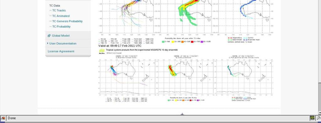
19 Products for a named storm MOGREPS-15: Ma-On, 12Z Fri 14 th July 2011 Left hand plot: 24 ensemble tracks Middle plot: strike probability i.e., probability that the storm will be within 75 miles within the next 15 days. Right hand plot: MOGREPS ensemble mean (blue), control (cyan), previous observations (red) and deterministic track (green)
20 Hurricane Sandy - Overview Formed in southern Caribbean Sea Landfalls over Jamaica, Cuba and Bahamas Initial peak intensity 110mph 957mb near Cuba top end Cat 2 Landfall over New Jersey with intensity 85mph 946mb Peak storm surge (4.38m) Most Sandy slides thanks to Julian Heming

21 ECMWF forecasts of Sandy
22 Met Office Deterministic Global Model Forecasts Formation predicted several days in advance Track through Caribbean and into open Atlantic very well predicted Right-of-track bias started near northern Bahamas Slow and right-of-track bias for USA landfall 00Z forecasts 12Z forecasts
23 MOGREPS Forecasts As Sandy was forming (7 days before US landfall) the strong probability of US landfall was flagged by MOGREPS Highest strike probabilities north of actual track (shown in black)
24 MOGREPS Forecasts 4 days before US landfall MOGREPS gave a good indication of landfall location
25 MOGREPS v. Met Office deterministic MOGREPS control and ensemble mean (blue tracks) were well to the left of the global deterministic track (green) On 23 rd & 24 th October MOGREPS gave a much better indication of US landfall. Actual track in red.


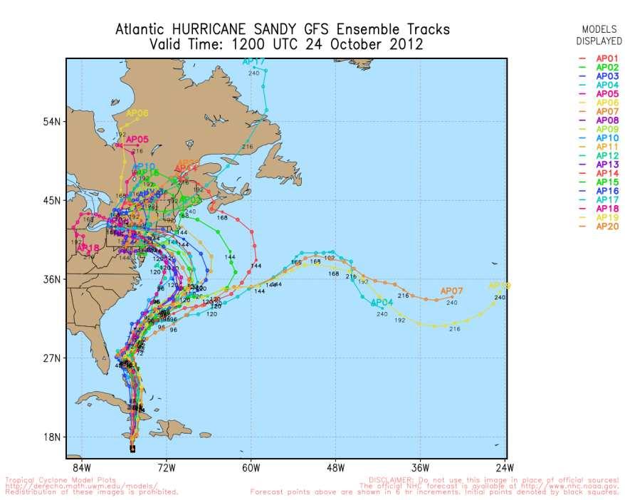
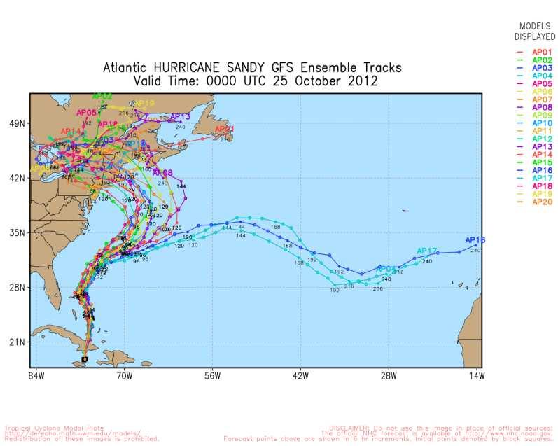
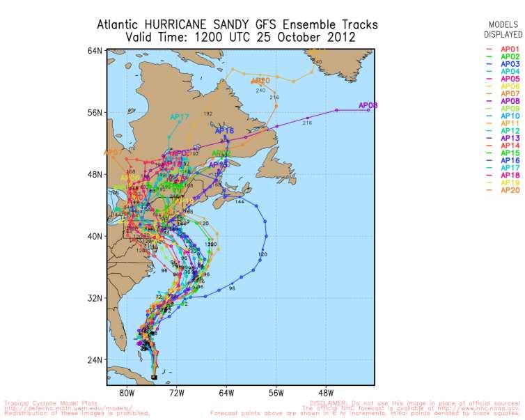
26 GFS ensembles 23 rd -25 th October 2012
27 Track comparisons from 00Z 24 th October 2012 ECMWF deterministic (dark blue) and MOGREPS ensemble mean (green) good guidance Met Office deterministic (red) and NHC guidance (light blue) much poorer
28 Track forecast errors Over the whole lifetime of Sandy, MOGREPS ensemble mean errors much lower than MO global deterministic model errors at longer lead times (> 72 hours)
29 Summary of forecasts for Sandy Met Office deterministic runs from 23 rd all had US landfall, but had a right bias which started over Bahamas ECMWF deterministic all had US landfall from 23 rd with smaller bias than Met Office model GFS deterministic did not feature a strong left turn until 12Z 25 th Nearly all MOGREPS members had US landfall from 00Z 23 rd onwards MOGREPS ensemble mean errors for whole storm lifetime lower than deterministic from T+72 onwards ECMWF ensemble flagged possibility of US landfall over 9 days ahead Majority of GFS ensemble members did not have US landfall until 24th
30 Towards the Global Interactive Forecast System (GIFS) Many weather forecast situations are low probability but high risk unlikely but potentially catastrophic. Probabilistic forecasting is a powerful tool to improve early warning of high-impact events. The objective of the GIFS is to realise the benefits of THORPEX research by developing and evaluating probabilistic products to deliver improved forecasts of high-impact weather. GIFS-TIGGE WG has initiated a GIFS development project to develop & evaluate products, focused on Tropical cyclones Heavy precipitation Strong winds
31 Tropical cyclones As a first step, the GIFS-TIGGE working group set up a pilot project for the exchange of real-time tropical cyclone predictions using Cyclone XML format. This was initiated to support the TPARC-08 campaign and has been continued. Example of combined TC track forecasts (Met Office + ECMWF)

32 CXML track exchange

33 Tropical cyclone products from MRI/JMA

34 Indian Ocean website at IMD
35 Use of MOGREPS-15 products in SWFDDP


36 Additional tropical cyclone products With the help of the EUfunded GEOWOW project, we have developed new products and are now delivering them to some SWFDP regional subprojects. Example - time series of forecast measures of cyclone intensity
37 Multi-model ensemble forecasts of Sandy Another new set of products is a multi-model version of the track and strike probability plots also now available for SWFDP.
38 How well can we forecast TC intensity? Category scores based on Vmax Global models Regional models Statistical Scores relative to statistical model using climatology & persistence Current NWP models do not add value to operational shortrange forecasts of TC intensity, but can improve on statistical models from ~day 2 onwards, when skill is very poor. Based on tropical cyclones for NW Pacific during 2010 & 2011 Hui Yu et al (WAF, early online release)
39 Improving Tropical Cyclone forecasts Potential for improved prediction of structure & intensity using high resolution nested ensembles. High-resolution simulation, by Stu Webster (Met Office)
40 Summary Ensemble forecasts are invaluable for forecasting the risks of severe weather, such as tropical cyclones. Combining forecasts from several skilful ensembles often produces better calibrated, and more statistically reliable results. The benefit of ensemble prediction has been demonstrated in forecasts of hurricane Sandy. Using TIGGE data, products are being developed to support the forecasting of tropical cyclones and other severe weather. The products will be evaluated in conjunction with the SWFDP. While current NWP models can do a good job at predicting tropical cyclone tracks, higher resolution models will probably be needed for improved intensity forecasts.
Medium-range Ensemble Forecasts at the Met Office
 Medium-range Ensemble Forecasts at the Met Office Christine Johnson, Richard Swinbank, Helen Titley and Simon Thompson ECMWF workshop on Ensembles Crown copyright 2007 Page 1 Medium-range ensembles at
Introduction to TIGGE and GIFS. Richard Swinbank, with thanks to members of GIFS-TIGGE WG & THORPEX IPO
 Introduction to TIGGE and GIFS Richard Swinbank, with thanks to members of GIFS-TIGGE WG & THORPEX IPO GIFS-TIGGE/NCAR/NOAA Workshop on EPS developments, June 2012 TIGGE THORPEX Interactive Grand Global
Upgrade of JMA s Typhoon Ensemble Prediction System
 Upgrade of JMA s Typhoon Ensemble Prediction System Masayuki Kyouda Numerical Prediction Division, Japan Meteorological Agency and Masakazu Higaki Office of Marine Prediction, Japan Meteorological Agency
GIFS-TIGGE working group Report to ICSC. Richard Swinbank Masayuki Kyouda with thanks to other members of GIFS-TIGGE WG and the THORPEX IPO
 GIFS-TIGGE working group Report to ICSC Richard Swinbank Masayuki Kyouda with thanks to other members of GIFS-TIGGE WG and the THORPEX IPO ICSC-11, Geneva, July 2013 GIFS-TIGGE report Working group membership
A review on recent progresses of THORPEX activities in JMA
 4th THORPEX workshop 31 Oct. 2012, Kunming, China A review on recent progresses of THORPEX activities in JMA Masaomi NAKAMURA Typhoon Research Department Meteorological Research Institute / JMA Contents
Fred Branski President CBS
 WMO Typhoon Haiyan, Prediction & Response Can we do better? Fred Branski, President, WMO Commission for Basic Systems Fred Branski President CBS AMS Washington Forum April 3, 2014 Prediction TIGGE makes
North Western Pacific Tropical Cyclone (Track) Ensemble Forecast Research Project (NW Pacific TC Project)
 Ensemble Forecast Research Project (NW Pacific TC Project)") TIGGE Real-Time Tropical Cyclone Data for Regional Applications North Western Pacific Tropical Cyclone (Track) Ensemble Forecast Research Project (NW Pacific TC Project) a WWRP Research Development Project
TIGGE Real-Time Tropical Cyclone Data for Regional Applications North Western Pacific Tropical Cyclone (Track) Ensemble Forecast Research Project (NW Pacific TC Project) a WWRP Research Development Project
NHC Ensemble/Probabilistic Guidance Products
 NHC Ensemble/Probabilistic Guidance Products Michael Brennan NOAA/NWS/NCEP/NHC Mark DeMaria NESDIS/STAR HFIP Ensemble Product Development Workshop 21 April 2010 Boulder, CO 1 Current Ensemble/Probability
Mio Matsueda (University of Oxford) Tetsuo Nakazawa (WMO)
 Tetsuo Nakazawa (WMO)") GIFS-TIGGE WG 10@UKMO (12-14 June, 2013) Early warning products for extreme weather events using operational medium-range ensemble forecasts Mio Matsueda (University of Oxford) Tetsuo Nakazawa (WMO) with
GIFS-TIGGE WG 10@UKMO (12-14 June, 2013) Early warning products for extreme weather events using operational medium-range ensemble forecasts Mio Matsueda (University of Oxford) Tetsuo Nakazawa (WMO) with
4.3.2 Configuration. 4.3 Ensemble Prediction System Introduction
 4.3 Ensemble Prediction System 4.3.1 Introduction JMA launched its operational ensemble prediction systems (EPSs) for one-month forecasting, one-week forecasting, and seasonal forecasting in March of 1996,
Probabilistic Weather Forecasting and the EPS at ECMWF
 Probabilistic Weather Forecasting and the EPS at ECMWF Renate Hagedorn European Centre for Medium-Range Weather Forecasts 30 January 2009: Ensemble Prediction at ECMWF 1/ 30 Questions What is an Ensemble
Fernando Prates. Evaluation Section. Slide 1
 Fernando Prates Evaluation Section Slide 1 Objectives Ø Have a better understanding of the Tropical Cyclone Products generated at ECMWF Ø Learn the recent developments in the forecast system and its impact
Numerical Weather Prediction. Medium-range multi-model ensemble combination and calibration
 Numerical Weather Prediction Medium-range multi-model ensemble combination and calibration Forecasting Research Technical Report No. 517 Christine Johnson and Richard Swinbank c Crown Copyright email:nwp
Ensemble Prediction Systems
 Ensemble Prediction Systems Eric Blake National Hurricane Center 7 March 2017 Acknowledgements to Michael Brennan 1 Question 1 What are some current advantages of using single-model ensembles? A. Estimates
Have a better understanding of the Tropical Cyclone Products generated at ECMWF
 Objectives Have a better understanding of the Tropical Cyclone Products generated at ECMWF Learn about the recent developments in the forecast system and its impact on the Tropical Cyclone forecast Learn
Feature-specific verification of ensemble forecasts
 Feature-specific verification of ensemble forecasts www.cawcr.gov.au Beth Ebert CAWCR Weather & Environmental Prediction Group Uncertainty information in forecasting For high impact events, forecasters
Current JMA ensemble-based tools for tropical cyclone forecasters
 Current JMA ensemble-based tools for tropical cyclone forecasters Hitoshi Yonehara(yonehara@met.kishou.go.jp) Yoichiro Ota JMA / Numerical Prediction Division Contents Introduction of JMA GSM and EPS NWP
Motivation & Goal. We investigate a way to generate PDFs from a single deterministic run
 Motivation & Goal Numerical weather prediction is limited by errors in initial conditions, model imperfections, and nonlinearity. Ensembles of an NWP model provide forecast probability density functions
2016 and 2017 Reviews of Probability-circle Radii in Tropical Cyclone Track Forecasts
 216 and 217 Reviews of Probability-circle Radii in Tropical Cyclone Track Forecasts Junya Fukuda Tokyo Typhoon Center, Forecast Division, Forecast Department, Japan Meteorological Agency 1. Introduction
Helen Titley and Rob Neal
 Processing ECMWF ENS and MOGREPS-G ensemble forecasts to highlight the probability of severe extra-tropical cyclones: Storm Doris UEF 2017, 12-16 June 2017, ECMWF, Reading, U.K. Helen Titley and Rob Neal
Tropical cyclone track forecasts using JMA model with ECMWF and JMA initial conditions
 Tropical cyclone track forecasts using JMA model with ECMWF and JMA initial conditions The Fourth THORPEX Asian Science Workshop Kunming, China 2 Nov 2012 (Fri) Munehiko Yamaguchi 1, Tetsuo Nakazawa 1,2
JMA Contribution to SWFDDP in RAV. (Submitted by Yuki Honda and Masayuki Kyouda, Japan Meteorological Agency) Summary and purpose of document
 Summary and purpose of document") WORLD METEOROLOGICAL ORGANIZATION COMMISSION FOR BASIC SYSTEMS OPAG on DPFS DPFS/RAV-SWFDDP-RSMT Doc. 7.1(1) (28.X.2010) SEVERE WEATHER FORECASTING AND DISASTER RISK REDUCTION DEMONSTRATION PROJECT (SWFDDP)
WORLD METEOROLOGICAL ORGANIZATION COMMISSION FOR BASIC SYSTEMS OPAG on DPFS DPFS/RAV-SWFDDP-RSMT Doc. 7.1(1) (28.X.2010) SEVERE WEATHER FORECASTING AND DISASTER RISK REDUCTION DEMONSTRATION PROJECT (SWFDDP)
TIGGE-LAM archive development in the frame of GEOWOW. Richard Mladek (ECMWF)
") TIGGE-LAM archive development in the frame of GEOWOW Richard Mladek (ECMWF) The group on Earth Observations (GEO) initiated the Global Earth Observation System of Systems (GEOSS) GEOWOW, short for GEOSS
TIGGE-LAM archive development in the frame of GEOWOW Richard Mladek (ECMWF) The group on Earth Observations (GEO) initiated the Global Earth Observation System of Systems (GEOSS) GEOWOW, short for GEOSS
Probabilistic Evaluation of Prediction and Dynamics of Super Typhoon MEGI (2010)
") Probabilistic Evaluation of Prediction and Dynamics of Super Typhoon MEGI (2010) 6 November 2012 Chuanhai Qian 1, Fuqing Zhang 2, Yihong Duan 1 1 China Meteorological Administration 2 Pennsylvania State
Probabilistic Evaluation of Prediction and Dynamics of Super Typhoon MEGI (2010) 6 November 2012 Chuanhai Qian 1, Fuqing Zhang 2, Yihong Duan 1 1 China Meteorological Administration 2 Pennsylvania State
The ECMWF Extended range forecasts
 The ECMWF Extended range forecasts Laura.Ferranti@ecmwf.int ECMWF, Reading, U.K. Slide 1 TC January 2014 Slide 1 The operational forecasting system l High resolution forecast: twice per day 16 km 91-level,
Recent Developments of JMA Operational NWP Systems and WGNE Intercomparison of Tropical Cyclone Track Forecast
 Recent Developments of JMA Operational NWP Systems and WGNE Intercomparison of Tropical Cyclone Track Forecast Chiashi Muroi Numerical Prediction Division Japan Meteorological Agency 1 CURRENT STATUS AND
COLORADO STATE UNIVERSITY FORECAST OF ATLANTIC HURRICANE ACTIVITY FROM AUGUST 4-17, 2015
 COLORADO STATE UNIVERSITY FORECAST OF ATLANTIC HURRICANE ACTIVITY FROM AUGUST 4-17, 2015 We expect that the next two weeks will be characterized by below-average amounts (
The benefits and developments in ensemble wind forecasting
 The benefits and developments in ensemble wind forecasting Erik Andersson Slide 1 ECMWF European Centre for Medium-Range Weather Forecasts Slide 1 ECMWF s global forecasting system High resolution forecast
MOGREPS short-range ensemble forecasting and the PREVIEW Windstorms Project
 MOGREPS short-range ensemble forecasting and the PREVIEW Windstorms Project Ken Mylne Thanks to all those who have contributed to both projects. Crown copyright 2007 Page 1 Outline MOGREPS System outline
Focus on parameter variation results
 Accounting for Model Uncertainty in the Navy s Global Ensemble Forecasting System C. Reynolds, M. Flatau, D. Hodyss, J. McLay, J. Moskaitis, J. Ridout, C. Sampson, J. Cummings Naval Research Lab, Monterey,
GFDL Hurricane Model Ensemble Performance During the 2012 Hurricane Season
 GFDL Hurricane Model Ensemble Performance During the 2012 Hurricane Season Tim Marchok (NOAA / GFDL) Matt Morin (DRC HPTG / GFDL) Morris Bender (NOAA / GFDL) HFIP Team Telecon 12 December 2012 Acknowledgments:
COLORADO STATE UNIVERSITY FORECAST OF ATLANTIC HURRICANE ACTIVITY FROM AUGUST 31 SEPTEMBER 13, 2012
 COLORADO STATE UNIVERSITY FORECAST OF ATLANTIC HURRICANE ACTIVITY FROM AUGUST 31 SEPTEMBER 13, 2012 We expect that the next two weeks will be characterized by average amounts (70-130 percent) of activity
NW Pacific Tropical Cyclone Ensemble Forecast Project
 NW Pacific Tropical Cyclone Ensemble Forecast Project a Joint Project of and TCP in WMO For ESAP/WMO Typhoon Committee Members and Forecasters/Researchers over the Globe Tetsuo NAKAZAWA WMO/ including
MOGREPS Met Office Global and Regional Ensemble Prediction System
 MOGREPS Met Office Global and Regional Ensemble Prediction System Ken Mylne Ensemble Forecasting Manager Crown copyright 2007 Forecaster Training MOGREPS and Ensembles. Page 1 Outline Introduction to Ensemble
ACCESS AGREPS Ensemble Prediction System
 ACCESS AGREPS Ensemble Prediction System Michael Naughton CAWCR Earth System Modelling Model Data Fusion Workshop 10-12 May 2010 Motivation for Ensemble Prediction NWP forecasts greatly improved but are
Probabilistic Weather Prediction
 Probabilistic Weather Prediction George C. Craig Meteorological Institute Ludwig-Maximilians-Universität, Munich and DLR Institute for Atmospheric Physics Oberpfaffenhofen Summary (Hagedorn 2009) Nothing
Application and verification of the ECMWF products Report 2007
 Application and verification of the ECMWF products Report 2007 National Meteorological Administration Romania 1. Summary of major highlights The medium range forecast activity within the National Meteorological
Current Issues and Challenges in Ensemble Forecasting
 Current Issues and Challenges in Ensemble Forecasting Junichi Ishida (JMA) and Carolyn Reynolds (NRL) With contributions from WGNE members 31 th WGNE Pretoria, South Africa, 26 29 April 2016 Recent trends
Report of GIFS-TIGGE WG (Submitted by Richard Swinbank and Masayuki Kyouda)
") WORLD METEOROLOGICAL ORGANIZATION COMMISSION FOR ATMOSPHERIC SCIENCES INTERNATIONAL CORE STEERING COMMITTEE FOR THORPEX Eleventh Session WMO, Geneva (15-17 July 2013) CAS/ICSC-11/DOC2.3.5 (24 VI.2013)
WORLD METEOROLOGICAL ORGANIZATION COMMISSION FOR ATMOSPHERIC SCIENCES INTERNATIONAL CORE STEERING COMMITTEE FOR THORPEX Eleventh Session WMO, Geneva (15-17 July 2013) CAS/ICSC-11/DOC2.3.5 (24 VI.2013)
The Use of GPS Radio Occultation Data for Tropical Cyclone Prediction. Bill Kuo and Hui Liu UCAR
 The Use of GPS Radio Occultation Data for Tropical Cyclone Prediction Bill Kuo and Hui Liu UCAR Current capability of the National Hurricane Center Good track forecast improvements. Errors cut in half
AnuMS 2018 Atlantic Hurricane Season Forecast
 AnuMS 2018 Atlantic Hurricane Season Forecast Issued: April 10, 2018 by Dale C. S. Destin (follow @anumetservice) Director (Ag), Antigua and Barbuda Meteorological Service (ABMS) The *AnuMS (Antigua Met
LAM EPS and TIGGE LAM. Tiziana Paccagnella ARPA-SIMC
 DRIHMS_meeting Genova 14 October 2010 Tiziana Paccagnella ARPA-SIMC Ensemble Prediction Ensemble prediction is based on the knowledge of the chaotic behaviour of the atmosphere and on the awareness of
Convective-scale NWP for Singapore
 Convective-scale NWP for Singapore Hans Huang and the weather modelling and prediction section MSS, Singapore Dale Barker and the SINGV team Met Office, Exeter, UK ECMWF Symposium on Dynamical Meteorology
COLORADO STATE UNIVERSITY FORECAST OF ATLANTIC HURRICANE ACTIVITY FROM AUGUST 2 AUGUST 15, 2013
 COLORADO STATE UNIVERSITY FORECAST OF ATLANTIC HURRICANE ACTIVITY FROM AUGUST 2 AUGUST 15, 2013 We expect that the next two weeks will be characterized by below-average amounts (
Tropical Cyclone Formation/Structure/Motion Studies
 Tropical Cyclone Formation/Structure/Motion Studies Patrick A. Harr Department of Meteorology Naval Postgraduate School Monterey, CA 93943-5114 phone: (831) 656-3787 fax: (831) 656-3061 email: paharr@nps.edu
AnuMS 2018 Atlantic Hurricane Season Forecast
 AnuMS 2018 Atlantic Hurricane Season Forecast : June 11, 2018 by Dale C. S. Destin (follow @anumetservice) Director (Ag), Antigua and Barbuda Meteorological Service (ABMS) The *AnuMS (Antigua Met Service)
11A.3 The Impact on Tropical Cyclone Predictions of a Major Upgrade to the Met Office Global Model
 11A.3 The Impact on Tropical Cyclone Predictions of a Major Upgrade to the Met Office Global Model Julian T. Heming * Met Office, Exeter, UK 1. BACKGROUND TO MODEL UPGRADE The last major upgrade to the
COLORADO STATE UNIVERSITY FORECAST OF ATLANTIC HURRICANE ACTIVITY FROM AUGUST 16 AUGUST 29, 2013
 COLORADO STATE UNIVERSITY FORECAST OF ATLANTIC HURRICANE ACTIVITY FROM AUGUST 16 AUGUST 29, 2013 We expect that the next two weeks will be characterized by above-average amounts (greater than 130 percent)
Model error and parameter estimation
 Model error and parameter estimation Chiara Piccolo and Mike Cullen ECMWF Annual Seminar, 11 September 2018 Summary The application of interest is atmospheric data assimilation focus on EDA; A good ensemble
AnuMS 2018 Atlantic Hurricane Season Forecast
 AnuMS 2018 Atlantic Hurricane Season Forecast Issued: May 10, 2018 by Dale C. S. Destin (follow @anumetservice) Director (Ag), Antigua and Barbuda Meteorological Service (ABMS) The *AnuMS (Antigua Met
Applications: forecaster perspective, training
 Applications: forecaster perspective, training Ken Mylne Met Office Also, Chair, WMO CBS Expert Team on Ensemble Prediction Thanks to: Anders Persson, Pierre Eckert, many others. Crown copyright 2004 Page
12.2 PROBABILISTIC GUIDANCE OF AVIATION HAZARDS FOR TRANSOCEANIC FLIGHTS
 12.2 PROBABILISTIC GUIDANCE OF AVIATION HAZARDS FOR TRANSOCEANIC FLIGHTS K. A. Stone, M. Steiner, J. O. Pinto, C. P. Kalb, C. J. Kessinger NCAR, Boulder, CO M. Strahan Aviation Weather Center, Kansas City,
The Impacts of GPS Radio Occultation Data on the Analysis and Prediction of Tropical Cyclones. Bill Kuo, Xingqin Fang, and Hui Liu UCAR COSMIC
 The Impacts of GPS Radio Occultation Data on the Analysis and Prediction of Tropical Cyclones Bill Kuo, Xingqin Fang, and Hui Liu UCAR COSMIC GPS Radio Occultation α GPS RO observations advantages for
Model error and seasonal forecasting
 Model error and seasonal forecasting Antje Weisheimer European Centre for Medium-Range Weather Forecasts ECMWF, Reading, UK with thanks to Paco Doblas-Reyes and Tim Palmer Model error and model uncertainty
2013 ATLANTIC HURRICANE SEASON OUTLOOK. June RMS Cat Response
 2013 ATLANTIC HURRICANE SEASON OUTLOOK June 2013 - RMS Cat Response Season Outlook At the start of the 2013 Atlantic hurricane season, which officially runs from June 1 to November 30, seasonal forecasts
1.2 DEVELOPMENT OF THE NWS PROBABILISTIC EXTRA-TROPICAL STORM SURGE MODEL AND POST PROCESSING METHODOLOGY
 1.2 DEVELOPMENT OF THE NWS PROBABILISTIC EXTRA-TROPICAL STORM SURGE MODEL AND POST PROCESSING METHODOLOGY Huiqing Liu 1 and Arthur Taylor 2* 1. Ace Info Solutions, Reston, VA 2. NOAA / NWS / Science and
Ensemble Prediction Systems
 Ensemble Prediction Systems Eric S. Blake & Michael J. Brennan National Hurricane Center 8 March 2016 Acknowledgements to Rick Knabb and Jessica Schauer 1 Why Aren t Models Perfect? Atmospheric variables
COLORADO STATE UNIVERSITY FORECAST OF ATLANTIC HURRICANE ACTIVITY FROM AUGUST 17 AUGUST 30, 2012
 COLORADO STATE UNIVERSITY FORECAST OF ATLANTIC HURRICANE ACTIVITY FROM AUGUST 17 AUGUST 30, 2012 We expect that the next two weeks will be characterized by above-average amounts (greater than 130 percent)
AnuMS 2018 Atlantic Hurricane Season Forecast
 AnuMS 2018 Atlantic Hurricane Season : August 12, 2018 by Dale C. S. Destin (follow @anumetservice) Director (Ag), Antigua and Barbuda Meteorological Service (ABMS) The *AnuMS (Antigua Met Service) is
ECMWF Medium-Range Forecast Graphical Products
 ECMWF Medium-Range Forecast Graphical Products Analysis Snow cover, ice cover, albedo, leaf area index, orography and sea depth Albedo Europe, Global, Central Europe, North West Europe, North East Europe,
PRMS WHITE PAPER 2014 NORTH ATLANTIC HURRICANE SEASON OUTLOOK. June RMS Event Response
 PRMS WHITE PAPER 2014 NORTH ATLANTIC HURRICANE SEASON OUTLOOK June 2014 - RMS Event Response 2014 SEASON OUTLOOK The 2013 North Atlantic hurricane season saw the fewest hurricanes in the Atlantic Basin
TIGGE at ECMWF. David Richardson, Head, Meteorological Operations Section Slide 1. Slide 1
 TIGGE at ECMWF David Richardson, Head, Meteorological Operations Section david.richardson@ecmwf.int Slide 1 Slide 1 ECMWF TIGGE archive The TIGGE database now contains five years of global EPS data Holds
Verification statistics and evaluations of ECMWF forecasts in
 635 Verification statistics and evaluations of ECMWF forecasts in 29-21 D.S. Richardson, J. Bidlot, L. Ferranti, A. Ghelli, T. Hewson, M. Janousek, F. Prates and F. Vitart Operations Department October
Ensemble TC Track/Genesis Products in
 Ensemble TC Track/Genesis Products in Parallel @NCO Resolution Members Daily Frequency Forecast Length NCEP ensemble (AEMN-para) GFS T574L64-33km(12/02/15) 20+1_CTL 00, 06, 12, 18 UTC 16 days (384hrs)
THORPEX A World Weather Research Programme
 THORPEX A World Weather Research Programme IMPLEMENTATION PLAN David Rogers, Chair WMO Expert Group for THORPEX International Research Implementation Plan THORPEX Management Structure agreed at ICSC-4
Radius of reliability: A distance metric for interpreting and verifying spatial probability forecasts
 Radius of reliability: A distance metric for interpreting and verifying spatial probability forecasts Beth Ebert CAWCR, Bureau of Meteorology Melbourne, Australia Introduction Wish to warn for high impact
Verification challenges in developing TC response procedures based on ensemble guidance
 Verification challenges in developing TC response procedures based on ensemble guidance Grant Elliott Senior Metocean Meteorologist ECMWF UEF 2016 workshop Disclaimer and important notice This presentation
Extended Prediction of North Indian Ocean Tropical Cyclones. James I. Belanger*, Peter J. Webster, Judith A. Curry, and Mark T.
 Extended Prediction of North Indian Ocean Tropical Cyclones James I. Belanger*, Peter J. Webster, Judith A. Curry, and Mark T. Jelinek School of Earth and Atmospheric Sciences, Georgia Institute of Technology,
Application and verification of ECMWF products 2016
 Application and verification of ECMWF products 2016 Icelandic Meteorological Office (www.vedur.is) Bolli Pálmason and Guðrún Nína Petersen 1. Summary of major highlights Medium range weather forecasts
Tropical Storm List
 Tropical Storm Email List http://tstorms.org/ tropical-storms@tstorms.org Tropical-Storms is a mailing list only for those who are professionally active in either the research or forecasting of tropical
Verification of ECMWF products at the Deutscher Wetterdienst (DWD)
") Verification of ECMWF products at the Deutscher Wetterdienst (DWD) DWD Martin Göber 1. Summary of major highlights The usage of a combined GME-MOS and ECMWF-MOS continues to lead to a further increase
Verification of ECMWF products at the Deutscher Wetterdienst (DWD) DWD Martin Göber 1. Summary of major highlights The usage of a combined GME-MOS and ECMWF-MOS continues to lead to a further increase
Exploiting ensemble members: forecaster-driven EPS applications at the met office
 Exploiting ensemble members: forecaster-driven EPS applications at the met office Introduction Ensemble Prediction Systems (EPSs) have assumed a central role in the forecast process in recent years. The
OBJECTIVE CALIBRATED WIND SPEED AND CROSSWIND PROBABILISTIC FORECASTS FOR THE HONG KONG INTERNATIONAL AIRPORT
 P 333 OBJECTIVE CALIBRATED WIND SPEED AND CROSSWIND PROBABILISTIC FORECASTS FOR THE HONG KONG INTERNATIONAL AIRPORT P. Cheung, C. C. Lam* Hong Kong Observatory, Hong Kong, China 1. INTRODUCTION Wind is
Storm Surge Forecast with Shifting Forecast Tracks
 Storm Surge Forecast with Shifting Forecast Tracks Storm Surge Findings in the Florida Keys Jon Rizzo Warning Coordination Meteorologist National Weather Service Florida Keys Florida Keys Life History
SIXTH INTERNATIONAL WORKSHOP on TROPICAL CYCLONES. Working Group: Phillipe Caroff, Jeff Callaghan, James Franklin, Mark DeMaria
 WMO/CAS/WWW Topic 0.1: Track forecasts SIXTH INTERNATIONAL WORKSHOP on TROPICAL CYCLONES Rapporteur: E-mail: Lixion A. Avila NOAA/National Hurricane Center 11691 SW 17th Street Miami, FL 33165-2149, USA
Verification of ECMWF products at the Finnish Meteorological Institute
 Verification of ECMWF products at the Finnish Meteorological Institute by Juha Kilpinen, Pertti Nurmi and Matias Brockmann 1. Summary of major highlights The new verification system is under pre-operational
Hurricane Harvey the Name says it all. by Richard H. Grumm and Charles Ross National Weather Service office State College, PA
 Hurricane Harvey the Name says it all by Richard H. Grumm and Charles Ross National Weather Service office State College, PA 16803. 1. Overview Hurricane Harvey crossed the Texas coast (Fig. 1) as a category
Topic 1: Motion. Recent Advances. Chairs: Grant Elliott 1 and Munehiko Yamaguchi 2
 Topic 1: Motion Recent Advances WMO 8 th International Workshop on Tropical Cyclones (IWTC-VIII) Jeju, Republic of Korea 2 December 2014 (Thu) Chairs: Grant Elliott 1 and Munehiko Yamaguchi 2 1: Australian
VERFICATION OF OCEAN WAVE ENSEMBLE FORECAST AT NCEP 1. Degui Cao, H.S. Chen and Hendrik Tolman
 VERFICATION OF OCEAN WAVE ENSEMBLE FORECAST AT NCEP Degui Cao, H.S. Chen and Hendrik Tolman NOAA /National Centers for Environmental Prediction Environmental Modeling Center Marine Modeling and Analysis
Severe storm forecast guidance based on explicit identification of convective phenomena in WRF-model forecasts
 Severe storm forecast guidance based on explicit identification of convective phenomena in WRF-model forecasts Ryan Sobash 10 March 2010 M.S. Thesis Defense 1 Motivation When the SPC first started issuing
Active Weather Threat Halloween Week Nor easter October 28 th 31 st 2012
 Active Weather Threat Halloween Week Nor easter October 28 th 31 st 2012 Prepared 1130 AM EDT Wednesday, October 24, 2012 Gary Szatkowski NOAA s NJ Forecast Office Weather.gov/phi Purpose of Briefing Briefing
EMC Probabilistic Forecast Verification for Sub-season Scales
 EMC Probabilistic Forecast Verification for Sub-season Scales Yuejian Zhu Environmental Modeling Center NCEP/NWS/NOAA Acknowledgement: Wei Li, Hong Guan and Eric Sinsky Present for the DTC Test Plan and
Verification of ensemble and probability forecasts
 Verification of ensemble and probability forecasts Barbara Brown NCAR, USA bgb@ucar.edu Collaborators: Tara Jensen (NCAR), Eric Gilleland (NCAR), Ed Tollerud (NOAA/ESRL), Beth Ebert (CAWCR), Laurence Wilson
Verification of Probability Forecasts
 Verification of Probability Forecasts Beth Ebert Bureau of Meteorology Research Centre (BMRC) Melbourne, Australia 3rd International Verification Methods Workshop, 29 January 2 February 27 Topics Verification
COLORADO STATE UNIVERSITY FORECAST OF ATLANTIC HURRICANE ACTIVITY FROM SEPTEMBER 15 SEPTEMBER 28, 2015
 COLORADO STATE UNIVERSITY FORECAST OF ATLANTIC HURRICANE ACTIVITY FROM SEPTEMBER 15 SEPTEMBER 28, 2015 We expect that the next two weeks will be characterized by below-average amounts (
NCEP Global Ensemble Forecast System (GEFS) Yuejian Zhu Ensemble Team Leader Environmental Modeling Center NCEP/NWS/NOAA February
 Yuejian Zhu Ensemble Team Leader Environmental Modeling Center NCEP/NWS/NOAA February") NCEP Global Ensemble Forecast System (GEFS) Yuejian Zhu Ensemble Team Leader Environmental Modeling Center NCEP/NWS/NOAA February 20 2014 Current Status (since Feb 2012) Model GFS V9.01 (Spectrum, Euler
NCEP Global Ensemble Forecast System (GEFS) Yuejian Zhu Ensemble Team Leader Environmental Modeling Center NCEP/NWS/NOAA February 20 2014 Current Status (since Feb 2012) Model GFS V9.01 (Spectrum, Euler
The 2009 Hurricane Season Overview
 The 2009 Hurricane Season Overview Jae-Kyung Schemm Gerry Bell Climate Prediction Center NOAA/ NWS/ NCEP 1 Overview outline 1. Current status for the Atlantic, Eastern Pacific and Western Pacific basins
The new ECMWF seasonal forecast system (system 4)
") The new ECMWF seasonal forecast system (system 4) Franco Molteni, Tim Stockdale, Magdalena Balmaseda, Roberto Buizza, Laura Ferranti, Linus Magnusson, Kristian Mogensen, Tim Palmer, Frederic Vitart Met.
The new ECMWF seasonal forecast system (system 4) Franco Molteni, Tim Stockdale, Magdalena Balmaseda, Roberto Buizza, Laura Ferranti, Linus Magnusson, Kristian Mogensen, Tim Palmer, Frederic Vitart Met.
Impact of GPS RO Data on the Prediction of Tropical Cyclones
 Impact of GPS RO Data on the Prediction of Tropical Cyclones Ying-Hwa Kuo, Hui Liu, UCAR Ching-Yuang Huang, Shu-Ya Chen, NCU Ling-Feng Hsiao, Ming-En Shieh, Yu-Chun Chen, TTFRI Outline Tropical cyclone
J11.5 HYDROLOGIC APPLICATIONS OF SHORT AND MEDIUM RANGE ENSEMBLE FORECASTS IN THE NWS ADVANCED HYDROLOGIC PREDICTION SERVICES (AHPS)
") J11.5 HYDROLOGIC APPLICATIONS OF SHORT AND MEDIUM RANGE ENSEMBLE FORECASTS IN THE NWS ADVANCED HYDROLOGIC PREDICTION SERVICES (AHPS) Mary Mullusky*, Julie Demargne, Edwin Welles, Limin Wu and John Schaake
J11.5 HYDROLOGIC APPLICATIONS OF SHORT AND MEDIUM RANGE ENSEMBLE FORECASTS IN THE NWS ADVANCED HYDROLOGIC PREDICTION SERVICES (AHPS) Mary Mullusky*, Julie Demargne, Edwin Welles, Limin Wu and John Schaake
2004 Hurricane Season: Climate Overview and Lessons Learned
 2004 Hurricane Season: Climate Overview and Lessons Learned Mark Saunders, PhD (Presenter: Milan Simic,, PhD, Benfield) Lead Scientist, Tropical Storm Risk Benfield Hazard Research Centre University College
ECMWF 10 th workshop on Meteorological Operational Systems
 ECMWF 10 th workshop on Meteorological Operational Systems 18th November 2005 Crown copyright 2004 Page 1 Monthly range prediction products: Post-processing methods and verification Bernd Becker, Richard
Development of JMA storm surge model
 2 nd JCOMM Scientific and Technical Symposium on Storm Surges 8-13 November 2015, Key West, Florida, USA Development of JMA storm surge model Hiroshi HASEGAWA (h_hasegawa@met.kishou.go.jp) Office of Marine
Introduction to THORPEX and TIGGE
 Introduction to THORPEX and TIGGE David Richardson Met Office, Exeter Thanks to: Mel Shapiro, Alan Thorpe, co-chairs THORPEX ISSC David Rogers and THORPEX Implementation Plan Expert Group Elena Manaenkova,
Forecast Challenges of the 2017 Hurricane Season and NHC Priorities for 2018
 Forecast Challenges of the 2017 Hurricane Season and NHC Priorities for 2018 Michael J. Brennan, Mark DeMaria, Eric S. Blake, Richard J. Pasch, Andrew Penny Annual HFIP Meeting 8 November 2017 Outline
Wassila Mamadou Thiaw Climate Prediction Center
 Sub-Seasonal to Seasonal Forecasting for Africa Wassila Mamadou Thiaw Climate Prediction Center NOAA Forecast Con/nuum e.g. Disaster management planning and response e.g. Crop Selec6on, Water management
COLORADO STATE UNIVERSITY FORECAST OF ATLANTIC HURRICANE ACTIVITY FROM SEPTEMBER 1 SEPTEMBER 14, 2015
 COLORADO STATE UNIVERSITY FORECAST OF ATLANTIC HURRICANE ACTIVITY FROM SEPTEMBER 1 SEPTEMBER 14, 2015 We expect that the next two weeks will be characterized by below-average amounts (
IMPACT OF GROUND-BASED GPS PRECIPITABLE WATER VAPOR AND COSMIC GPS REFRACTIVITY PROFILE ON HURRICANE DEAN FORECAST. (a) (b) (c)
 (b) (c)") 9B.3 IMPACT OF GROUND-BASED GPS PRECIPITABLE WATER VAPOR AND COSMIC GPS REFRACTIVITY PROFILE ON HURRICANE DEAN FORECAST Tetsuya Iwabuchi *, J. J. Braun, and T. Van Hove UCAR, Boulder, Colorado 1. INTRODUCTION
9B.3 IMPACT OF GROUND-BASED GPS PRECIPITABLE WATER VAPOR AND COSMIC GPS REFRACTIVITY PROFILE ON HURRICANE DEAN FORECAST Tetsuya Iwabuchi *, J. J. Braun, and T. Van Hove UCAR, Boulder, Colorado 1. INTRODUCTION
Web-Based Decision Support Tool
 Web-Based Decision Support Tool PAULA MCCASLIN AND KIRK HOLUB NOAA / GSD 5/11/11 NOAA Earth Systems Research Laboratory Personal Weather Advisor (concept idea) Decision Support in Weather-Sensitive Situations
COLORADO STATE UNIVERSITY FORECAST OF ATLANTIC HURRICANE ACTIVITY FROM AUGUST 18-31, 2017
 COLORADO STATE UNIVERSITY FORECAST OF ATLANTIC HURRICANE ACTIVITY FROM AUGUST 18-31, 2017 We expect that the next two weeks will be characterized by above-average amounts (>130%) of activity relative to