and 24 mm, hPa lapse rates between 3 and 4 K km 1, lifted index values
|
|
|
- Aubrey Carpenter
- 5 years ago
- Views:
Transcription
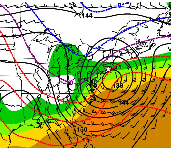
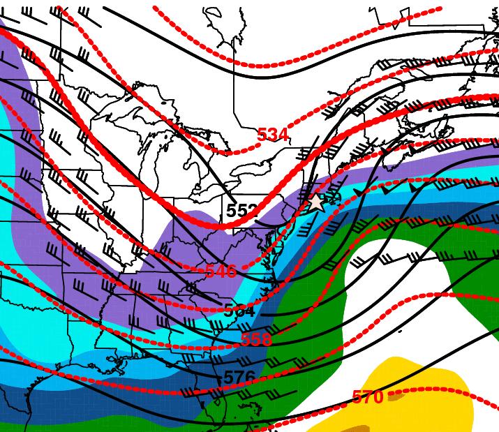
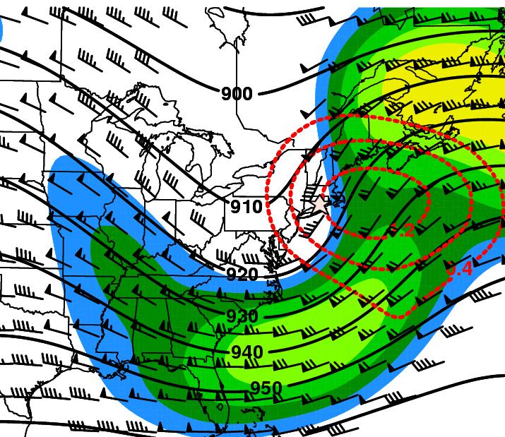
1 3.2 Composite analysis Pure gradient composites The composite initial NE report in the pure gradient northwest composite (N = 32) occurs where the mean sea level pressure (MSLP) gradient is strongest in a region where a stream of warm moist air is transported poleward (Figs. 3.6a,b). This stream of warm moist air wraps cyclonically around the north side of the composite surface cyclone center toward the location of the composite initial NE report (Fig. 3.6a). The composite initial NE report occurs in a region characterized by precipitable water values between 20 and 24 mm, hPa lapse rates between 3 and 4 K km 1, lifted index values between 10 and 13 K, and hPa shear values near 45 kt (Figs. 3.6a c). Warm advection is occurring at 850 hpa in the vicinity of the composite initial NE report (Fig. 3.6b). The composite surface cyclone is located downstream of a 300-hPa trough axis where there is horizontal divergence of the total wind (Figs. 3.6a,d), which is favorable for cyclogenesis and strengthening of low-level wind speeds. The composite 300-hPa wind speed analysis can be misleading. Although the composite 300-hPa wind speed analysis indicates two jet streaks (Fig. 3.6d), subjective analysis indicates that 14 events were associated with two jet streaks, whereas six and nine events were associated with an entrance and exit region of a jet streak, respectively. Three events were deemed ambiguous. Thus, there is uncertainty regarding the preferred jet structure associated with pure gradient northwest events. Northeast of the composite surface cyclone, MSLP falls are approximately 12 hpa (12 h) 1 (Fig. 3.6e). The composite initial NE report occurs where the isallobaric, or MSLP tendency, gradient is strongest (Fig. 3.6e). 36
2 The composite initial NE report in the pure gradient southwest composite (N = 55) occurs in a region where the MSLP gradient is strongest (Fig. 3.7a). The environment in which the composite initial NE report occurs is characterized by precipitable water values less than 12 mm, hPa lapse rates between 6 and 7 K km 1, lifted index values between 13 and 16 K, and hPa shear values near 35 kt (Figs. 3.7a c). Cold advection is occurring at 850 hpa in the vicinity of the composite initial NE report (Fig. 3.7b). As in the pure gradient northwest composite, the composite surface cyclone is located downstream of a 300-hPa trough axis where there is horizontal divergence of the total wind (Figs. 3.7a,d), which is favorable for cyclogenesis and strengthening of low-level wind speeds. As was the case with the pure gradient northwest composite, there is uncertainty regarding the preferred 300-hPa jet structure associated with pure gradient southwest events. Although the 300-hPa wind speed analysis indicates a single jet streak with the composite surface cyclone located in the poleward-jet exit region (Figs. 3.7a,d), subjective analysis indicates that 25 events were associated with an exit region of a jet streak, whereas 3 and 24 events were associated with an entrance region of a jet streak and two jet streaks, respectively. Three events were deemed ambiguous. The composite initial NE report occurs within the isallobaric gradient where MSLP is rising (Fig. 3.7e). The minimum in MSLP appears to extend northeastward from the composite cyclone center (Fig. 3.7e), which is a reflection of large latitudinal and longitudinal variation in the location of the individual surface cyclones that make up the composite. The composite initial NE report in the southwest composite cross section typically occurs in a region of strong northwesterly flow, subsidence, and cold advection as indicated by a backing wind profile (Fig. 3.8). A 37
3 composite sounding taken at the location of the composite initial NE report at t = 06 h, t = 00 h, and t = +06 h indicates that at low levels from t = 06 h to t = +06 h the profile cools as indicated by the temperature profile shifting to colder temperatures, becomes drier as indicated by an increase in the dewpoint depression, and the wind speeds strengthen at all levels (Fig. 3.9). Cooling at 925 hpa is greater than at 1000 hpa, which allows for an approximately dry adiabatic hPa lapse rate to develop at t = +06 h (Fig. 3.9). Steep low-level lapse rates promote turbulent transport of high momentum air to the surface. The composite initial NE report in the pure gradient southeast composite (N = 45) occurs in a region where a stream of warm moist air is transported poleward ahead of an imminent cold-frontal passage (Figs. 3.10a,b). The environment in which the composite initial NE report occurs is characterized by precipitable water values between 20 and 24 mm, hPa lapse rates between 3 and 4 K km 1, lifted index values between 10 and 13 K, and hPa shear values near 50 kt (Figs. 3.10a c). Cold and warm advection is occurring at the trough base and ridge crest, respectively, which suggests that the 500-hPa flow pattern is amplifying (Fig. 3.10c). The pure gradient southeast composite surface cyclone is located beneath a region where there is horizontal divergence of the total wind (Figs. 3.10a,d), which is favorable for cyclogenesis and strengthening of low-level wind speeds. As in the previous composites, the composite 300-hPa wind speed analysis can be misleading. Although the 300-hPa wind speed analysis indicates two jet streaks (Fig. 3.10d), subjective analysis indicates that 28 events were associated with two jet streaks, whereas 2 and 13 events were associated with an entrance and exit region of a jet streak, respectively. Two events were deemed 38
4 ambiguous. As in the pure gradient southwest composite, the isallobaric couplet for the pure gradient southeast composite differs from the pure gradient northwest composite in that the MSLP rises west of the composite surface cyclone are more rapid in the pure gradient southeast composite (Fig. 3.10e). The composite initial NE report occurs approximately in the location of the strongest isallobaric gradient where the MSLP is falling (Fig. 3.10e). A cross section through the line drawn in Fig. 3.5a reveals the composite initial NE report occurs in a region of ascent ahead of a cold front where the relative humidity at the surface is approximately 85% and the 1000-hPa wind speeds are strongest (Fig. 3.11). The composite initial NE report in the pure gradient northeast composite (N = 33) occurs where the MSLP gradient is strongest (Fig. 3.12a). The composite initial NE report occurs where a stream of warm moist air is transported poleward in the presence of onshore flow along the Atlantic coast (Fig. 3.12a). Reduced frictional drag is typically observed over the ocean, which allows low-level wind speeds along the Atlantic coast to be stronger compared to over land (Stull 1988, p. 213). The environment in which the composite initial NE report occurs is characterized by precipitable water values between 20 and 24 mm, hPa lapse rates less than 3 K km 1, lifted index values greater than 16 K, and hPa shear values near 60 kt (Figs. 3.12a c). Warm advection is occurring at 850 hpa in the vicinity of the composite initial NE report (Fig. 3.12b). As in the pure gradient northwest, southwest, and southeast composites, the northeast composite surface cyclone is located downstream of an upper-level trough axis where there is horizontal divergence of the total wind (Fig. 3.12d), which is favorable for cyclogenesis and strengthening of low-level wind speeds. There is uncertainty regarding 39
5 the preferred 300-hPa jet structure associated with the pure gradient northeast composite. Although the composite 300-hPa wind speed analysis indicates two jet streaks (Fig. 3.12d), subjective analysis indicates that 16 events were associated with two jet streaks, whereas 10 and 6 events were associated with an entrance and exit region of a jet streak, respectively. One event was deemed ambiguous. Unlike the pure gradient northwest, southwest, and southeast composites, the composite initial NE report for the northeast composite occurs at the isallobaric minimum instead of in a region where the isallobaric gradient is strong (Fig. 3.12e) Hybrid composites The composite initial NE report in the hybrid northwest composite (N = 8) occurs where the mean sea level pressure (MSLP) gradient is strongest in a region where a stream of warm moist air is transported poleward (Figs. 3.13a,b). This stream of warm moist air wraps cyclonically around the north side of the composite surface cyclone center toward the location of the composite initial NE report (Fig. 3.13a). The composite initial NE report occurs in a region characterized by precipitable water values between 20 and 24 mm, hPa lapse rates between 4 and 5 K km 1, lifted index values between 10 and 13 K, and hPa shear values near 50 kt (Figs. 3.13a c). Warm advection is occurring at 850 hpa in the vicinity of the composite initial NE report (Fig. 3.13b). The composite surface cyclone is located downstream of a 300-hPa trough axis where there is horizontal divergence of the total wind (Figs. 3.13a,d), which is favorable for cyclogenesis and strengthening of low-level wind speeds. The composite 300-hPa wind speed analysis can be misleading. Although the composite 300-hPa wind speed 40
6 analysis indicates two jet streaks (Fig. 3.13d), subjective analysis indicates that four events were associated with two jet streaks, whereas two events each were associated with an entrance and exit region of a jet streak, respectively. No events were deemed ambiguous. Thus, there is uncertainty regarding the preferred jet structure associated with pure gradient northwest events. Northeast of the composite surface cyclone, MSLP falls are approximately 18 hpa (12 h) 1 (Fig. 3.13e). The composite initial NE report occurs where the isallobaric, or MSLP tendency, gradient is strongest (Fig. 3.13e). The hybrid northwest events average less than one thunderstorm-wind report per event. Six of the eight hybrid northwest events did not accumulate any thunderstorm-wind reports, and were deemed hybrid events because a lightning flash report occurred within the vicinity of a gradient-wind report. The composite initial NE report in the hybrid southwest composite (N = 14) occurs in a region where the MSLP gradient is strongest (Fig. 3.14a). The environment in which the composite initial NE report occurs is characterized by precipitable water values between 12 and 16 mm, hPa lapse rates between 6 and 7 K km 1, lifted index values between 7 and 10 K, and hPa shear values near 50 kt (Figs. 3.14a c). Cold advection is occurring at 850 hpa in the vicinity of the composite initial NE report (Fig. 3.14b). The composite surface cyclone is located downstream of a 300- hpa trough axis where there is horizontal divergence of the total wind (Figs. 3.14a,d), which is favorable for cyclogenesis and strengthening of low-level wind speeds. There is uncertainty regarding the preferred 300-hPa jet structure associated with hybrid southwest events. Although the 300-hPa wind speed analysis indicates a single jet streak with the composite surface cyclone located in the poleward-jet exit region (Figs. 3.14a,d), 41
7 subjective analysis indicates that five events were associated with an exit region of a jet streak, whereas two and six events were associated with an entrance region of a jet streak and two jet streaks, respectively. One event was deemed ambiguous. The composite initial NE report occurs within the isallobaric gradient where MSLP is rising (Fig. 3.14e). The hybrid southwest composite differs from the pure gradient southwest composite in the following ways: 1) the MSLP does not exhibit the northeastward extension as is evident in the pure gradient southwest composite, which is a reflection of less latitudinal and longitudinal variation in the location of the individual cyclones that constitute the hybrid southwest composite compared to the individual cyclones that constitute the pure gradient southwest composite; and 2) the composite initial NE report is located in a region that is slightly warmer, more moist, and less stable (as indicated by lower lifted index values) compared to the pure gradient southwest composite (Figs. 3.7a c). As in the pure gradient southwest composite, the hybrid southwest composite is associated with hPa lapse rate values between 6 and 7 K km 1 (Fig. 3.14b). The hybrid southeast composite (N = 71) represents the typical synoptic environment of most high-wind events, based upon the number of members in the composite. The composite initial NE report occurs in a region where warm moist air is drawn poleward from the Gulf of Mexico (Fig. 3.15a). The composite initial NE report occurs in a region characterized by precipitable water values between 24 and 28 mm, hPa lapse rates between 4 and 5 K km 1, lifted index values between 4 and 7 K, and hPa shear values near 50 kt (Figs. 3.15a c). The 850-hPa wind and temperature composite analyses indicate that a cold-frontal passage is imminent in the vicinity of the composite initial NE report (Fig. 3.15b). The 500-hPa flow and
8 500-hPa thickness pattern indicates that cold and warm advection is occurring at the 500- hpa trough base and ridge crest, respectively, which suggests the 500-hPa flow pattern is amplifying at the time of the composite initial NE report (Fig. 3.15c). The composite surface cyclone typically occurs downstream of a 300-hPa trough axis where there is horizontal divergence of the total wind (Fig. 3.15d). Although the composite 300-hPa wind speed analysis suggests a single jet streak configuration (Fig. 3.15d), subjective analysis indicates that 27 events were associated with two jet streaks, whereas 15 and 26 events were associated with an entrance and exit region of a jet streak, respectively. Three events were deemed ambiguous. Thus, there is uncertainty regarding the preferred jet structure associated with hybrid southeast events. The composite initial NE report again occurs where the isallobaric gradient is the strongest (Fig. 3.15e). A vertical cross section taken through the line in Fig. 3.15a indicates the composite initial NE report occurs at the leading edge of a cold front where ascent is occurring in the presence of potentially unstable air (Fig. 3.16). A comparison of the hybrid and pure gradient southeast composite cross sections reveals that the pure gradient southeast composite depicts more stable air (equivalent potential temperature increases with height at a greater rate) and does not indicate a region of potential instability at the leading edge of a cold front (Figs and 3.16). Sufficiently lifting the moist, potentially unstable air would allow for thunderstorms and thunderstorm-related downdrafts to develop along the cold front. For the hybrid southeast events, 29 (41%) of the initial NE reports for the hybrid southeast events were thunderstorm-wind reports, suggesting that severe gradient winds that occur ahead of a cold front mix down to the surface prior to the occurrence of thunderstorm-related downdrafts. 43
9 The composite initial NE report in the pure gradient northeast composite (N = 30) occurs where the MSLP gradient is strongest (Fig. 3.17a). As in the pure gradient northeast composite, the composite initial NE report occurs where a stream of warm moist air is transported poleward in the presence of onshore flow along the Atlantic coast (Fig. 3.17a). Reduced frictional drag is typically observed over the ocean, which allows low-level wind speeds along the Atlantic coast to be stronger compared to over land (Stull 1988, p. 213). The environment in which the composite initial NE report occurs is characterized by precipitable water values between 24 and 28 mm, hPa lapse rates less than 3 K km 1, lifted index values between 7 and 10 K, and hPa shear values near 60 kt (Figs. 3.17a c). Warm advection is occurring at 850 hpa in the vicinity of the composite initial NE report (Fig. 3.17b). The hybrid northeast composite surface cyclone is located downstream of an upper-level trough axis where there is horizontal divergence of the total wind (Fig. 3.17d), which is favorable for cyclogenesis and strengthening of low-level wind speeds. There is uncertainty regarding the preferred 300-hPa jet structure associated with the hybrid northeast composite. Although the composite 300-hPa wind speed analysis indicates two jet streaks (Fig. 3.17d), subjective analysis indicates that 10 events were associated with two jet streaks, whereas 12 and 8 events were associated with an entrance and exit region of a jet streak, respectively. No events were deemed ambiguous. As in the pure gradient northeast composite, the composite initial NE report for the hybrid northeast composite occurs at the isallobaric minimum (Fig. 3.17e). The hybrid northeast composite initial NE report occurs in region that is warmer, more moist, and less stable (Figs. 3.17a c; as indicated by lower lifted index values) compared to the pure gradient northeast composite (Figs. 3.12a c). The 44
10 hybrid northeast events average approximately six thunderstorm-wind reports per event. Of the 30 hybrid northeast events, 13 events did not accumulate any thunderstorm-wind reports, but were considered hybrid events because a lightning flash report occurred within the vicinity of a gradient-wind report. Only 3 of the 17 hybrid northeast events that accumulated a thunderstorm-wind report began with a thunderstorm-wind report Pure convective composites The pure convective trough composite (N = 34) is typically associated with a surface cyclone located to the northwest of the composite initial NE report (Fig. 3.18a). Similar to the hybrid southeast composite (Figs. 3.15b), the pure convective trough composite initial NE report occurs in association with a cold-frontal passage (Fig. 3.18b). The composite initial NE report also occurs in a region of near 35 kt hPa shear values coincide with lifted index values between 0.5 and 1 K (Fig. 3.18c). The 500-hPa flow pattern appears to be less amplified (Fig. 3.18c) and the 300-hPa jet streak wind speeds appear to be weaker (Fig. 3.18d) compared to the hybrid southeast composite (Fig. 3.15d). The composite initial NE report occurs in region characterized by ascent in the presence of potentially unstable air (Fig. 3.19). Sufficiently lifting potentially unstable air would allow for thunderstorms and thunderstorm-related downdrafts to form. The pure convective ridge composite (N = 9) consists of a northwest-to-southeast oriented baroclinic zone located over the NE with the composite initial NE report occurring on the warm side of the baroclinic zone (Fig. 3.20a). Warm advection is evident at 850 hpa (Fig. 3.20b). The composite initial NE report occurs in a region characterized by hPa lapse rates between 3 and 4 K km 1 (Fig. 3.20b). The 45
11 composite initial NE report also occurs in a region of near 40 kt hPa shear values coincide with lifted index values between 1 and 4 K (Fig. 3.20c). The composite initial NE report occurs in the equatorward entrance region of a 300-hPa northwesterly jet where there is horizontal divergence of the total wind (Fig. 3.20d). A cross section through the baroclinic zone indicated in Fig. 3.20a reveals that the composite initial NE report occurs in a region of ascent in the presence of potentially unstable air (Fig. 3.21). The presence of dry air at midlevels suggests that entrainment of dry air and evaporative cooling could play a role in the development of thunderstorm-related downdrafts Composite surface cyclone tracks Composite surface cyclone tracks for each pure gradient and hybrid subcategory are presented in Figs. 3.22a and b, respectively. The composite surface cyclone center tends to track from southwest to northeast for all composite subcategories. Based upon the number of events associated with the hybrid southeast composite, the most common surface cyclone track is the hybrid southeast composite. The pure gradient northwest, southwest, and northeast composite surface cyclone centers tend to track along the coast of the NE, whereas the hybrid southeast and northeast composite surface cyclone centers tend to track further inland along the NE (Fig. 3.22). The hybrid southeast composite surface cyclone track is more meridionally oriented compared to the pure gradient southeast composite surface cyclone track, which is consistent with flow throughout the troposphere in the hybrid southeast composite having a southerly component (Figs. 3.15a d) compared to the pure gradient southeast composite (Figs. 3.10a d). Because the hybrid southeast composite surface cyclone originates closer to the Gulf of Mexico (at t = 24 h the hybrid southeast composite surface cyclone is located in Missouri whereas the 46
12 pure gradient southeast composite surface cyclone is located in Iowa), has more of a meridionally oriented track, and ends at a slightly higher latitude at t = + 24 h compared to the pure gradient southeast composite surface cyclone, the hybrid southeast composite surface cyclone would draw warmer, more moist, and thus less stable air to higher latitudes compared to the pure gradient southeast composite surface cyclone. The pure gradient and hybrid northeast composite surface cyclone tracks differ in that the hybrid northeast composite surface cyclone tracks north of the composite initial NE report along the interior of the NE, whereas the pure gradient northeast composite surface cyclone tends to track slightly south of the composite initial NE report along the coast (Figs. 3.22a,b). The composite cyclone tracks relative to the composite initial NE reports for the hybrid northwest, southwest, and southeast composites are consistent with the pure gradient northwest, southwest, and southeast composite cyclone tracks (Figs. 3.22a,b). 47
 (d)")
13 (a) (b) (c) (d) 48
 depicting the location of the composite initial NE report (star) and: (a) MSLP (hpa, solid), 1000 500-hPa thickness (dam, dashed), precipitable water (mm,")
14 (e) Fig 3.6. Pure gradient northwest composite (N = 32) depicting the location of the composite initial NE report (star) and: (a) MSLP (hpa, solid), hPa thickness (dam, dashed), precipitable water (mm, shaded), 1000-hPa total wind (kt, barbs); (b) 850- hpa geopotential height (dam, solid), temperature ( C, dashed), lapse rate (K km 1, shaded), 850-hPa total wind (kt, barbs); (c) 500-hPa geopotential height (dam, solid), hPa thickness (dam, dashed), lifted index (K, shaded), hPa shear vector (kt, barbs); (d) 300-hPa geopotential height (dam, solid), horizontal divergence of the total wind (10 5 s 1, dashed), wind speed (kt, shaded), 300-hPa total wind (kt, barbs); and (e) MSLP (hpa, solid) and 12-h centered MSLP change [hpa (12 h) 1, dashed]. 49


15 (a) (b) (c) (d) (e) Fig As in Fig 3.1 except for the pure gradient southwest composite (N = 55). The black line in panel (a) indicates the orientation of the cross section shown in Fig
 cross section depicting equivalent potential temperature (K, solid), vertical motion")
, and the location of the initial NE report (star). Fig. 3.9.")
16 Fig Pure gradient southwest composite (N = 55) cross section depicting equivalent potential temperature (K, solid), vertical motion (10 3 Pa s 1, dashed; upward indicated in red, downward indicated in blue), relative humidity (%, shaded), horizontal component of the total wind (kt, barbs), and the location of the initial NE report (star). Fig Pure gradient southwest composite (N = 55) soundings taken at the location of the initial NE report at t = 06 h (red), t = 00 h (purple), and t = +06 h (blue). 51


17 (a) (b) (c) (d) (e) Fig As in Fig 3.1 except for the pure gradient southeast composite (N = 45). The black line in panel (a) indicates the orientation of the cross section shown in Fig
18 Fig As in Fig. 3.3 except for the pure gradient southeast composite (N = 45). 53
 (d)")


19 (a) (b) (c) (d) (e) Fig As in Fig 3.1 except for the pure gradient northeast composite (N = 33). 54
 (d)")


20 (a) (b) (c) (d) (e) Fig As in Fig 3.1 except for the hybrid northwest composite (N = 8). 55
 (d)")


21 (a) (b) (c) (d) (e) Fig As in Fig 3.1 except for the hybrid southwest composite (N = 14). 56


.")
 indicates")

22 (a) (b) (c) (d) (e) Fig As in Fig 3.1 except for the hybrid southeast composite (N = 71). The black line in panel (a) indicates the orientation of the cross section shown in Fig
23 Fig As in Fig. 3.3 except for the hybrid southeast composite (N = 71). 58
 (d)")


24 (a) (b) (c) (d) (e) Fig As in Fig 3.1 except for the hybrid northeast composite (N = 30). 59


")


25 (a) (b) (c) (d) Fig As in Fig 3.1 except for the pure convective trough composite (N = 34). The black line in panel (a) indicates the orientation of the cross section shown in Fig Fig As in Fig. 3.3 except for the pure convective trough composite (N = 34). 60


")


26 (a) (b) (c) (d) Fig As in Fig 3.1 except for the pure convective ridge composite (N = 9). The black line in panel (a) indicates the orientation of the cross section shown in Fig Fig As in Fig. 3.3 except for the pure convective ridge composite (N = 9). 61
 pure")

27 (a) (b) Fig Composite surface cyclone tracks for each subcategory based upon the location of the composite cyclone center at 6-hourly time intervals for the (a) pure gradient and (b) hybrid event types. The shaded box and black dot represent the central pressure and location of the composite surface cyclone at t = 00 h, respectively. The star represents the location of the composite initial NE report. The pure gradient southwest, hybrid southwest, and hybrid northwest composite surface cyclone tracks do not extend to t = 24 h, because a coherent center of low MSLP was not evident in the composite at those times. 62
Weather report 28 November 2017 Campinas/SP
 Weather report 28 November 2017 Campinas/SP Summary: 1) Synoptic analysis and pre-convective environment 2) Verification 1) Synoptic analysis and pre-convective environment: At 1200 UTC 28 November 2017
Multiscale Analyses of Inland Tropical Cyclone Midlatitude Jet Interactions: Camille (1969) and Danny (1997)
 and Danny (1997)") Multiscale Analyses of Inland Tropical Cyclone Midlatitude Jet Interactions: Camille (1969) and Danny (1997) Matthew Potter, Lance Bosart, and Daniel Keyser Department of Atmospheric and Environmental
Multiscale Analyses of Inland Tropical Cyclone Midlatitude Jet Interactions: Camille (1969) and Danny (1997) Matthew Potter, Lance Bosart, and Daniel Keyser Department of Atmospheric and Environmental
Summary of High Wind Event of 7 March 2004
 Summary of High Wind Event of 7 March 2004 This event was characterized by a very strong jet streak that developed over North Carolina by 00 UTC 8 March, as seen in the Eta model analysis at 300 mb, with
Vertical structure. To conclude, we will review the critical factors invloved in the development of extratropical storms.
 Vertical structure Now we will examine the vertical structure of the intense baroclinic wave using three visualization tools: Upper level charts at selected pressure levels Vertical soundings for selected
Fronts in November 1998 Storm
 Fronts in November 1998 Storm Much of the significant weather observed in association with extratropical storms tends to be concentrated within narrow bands called frontal zones. Fronts in November 1998
Synoptic Meteorology II: Petterssen-Sutcliffe Development Theory Application March 2015
 Synoptic Meteorology II: Petterssen-Sutcliffe Development Theory Application 10-12 March 2015 In our lecture on Petterssen-Sutcliffe Development Theory, we outlined the principle of selfdevelopment in
Mid-Latitude Cyclones and Fronts. Lecture 12 AOS 101
 Mid-Latitude Cyclones and Fronts Lecture 12 AOS 101 Homework 4 COLDEST TEMPS GEOSTROPHIC BALANCE Homework 4 FASTEST WINDS L Consider an air parcel rising through the atmosphere The parcel expands as it
Science Olympiad Meteorology Quiz #1 Page 1 of 7
 1) What is generally true about the stratosphere: a) Has turbulent updrafts and downdrafts. b) Has either a stable or increasing temperature profile with altitude. c) Where the auroras occur. d) Both a)
Synoptic Meteorology II: Frontogenesis Examples Figure 1
 Synoptic Meteorology II: Frontogenesis Examples The below images, taken from the 1200 UTC 17 January 2019 GFS forecast run, provide examples of the contributions of deformation and divergence to frontogenesis.
Lec 10: Interpreting Weather Maps
 Lec 10: Interpreting Weather Maps Case Study: October 2011 Nor easter FIU MET 3502 Synoptic Hurricane Forecasts Genesis: on large scale weather maps or satellite images, look for tropical waves (Africa
Final Examination, MEA 443 Fall 2008, Lackmann
 Place an X here to count it double! Name: Final Examination, MEA 443 Fall 2008, Lackmann If you wish to have the final exam count double and replace your midterm score, place an X in the box above. As
Weather Systems III: Thunderstorms and Twisters
 Weather Systems III: Thunderstorms and Twisters Review 1. Definition of airmasses? Bergeron classification of air masses 2. Surface weather analysis: Station model, wind speed code, present weather 3.
Lower-Tropospheric Height Tendencies Associated with the Shearwise and Transverse Components of Quasigeostrophic Vertical Motion
 JULY 2007 N O T E S A N D C O R R E S P O N D E N C E 2803 Lower-Tropospheric Height Tendencies Associated with the Shearwise and Transverse Components of Quasigeostrophic Vertical Motion JONATHAN E. MARTIN
Chapter 9: Weather Patterns
 Chapter 9: Weather Patterns Mid Latitude Cyclones: extratropical cyclones, Nor easters Region southern FL to Alaska Lifecycle and associated weather Regional Influence Polar Front Theory: -Norwegian Cyclone
AIR MASSES. Large bodies of air. SOURCE REGIONS areas where air masses originate
 Large bodies of air AIR MASSES SOURCE REGIONS areas where air masses originate Uniform in composition Light surface winds Dominated by high surface pressure The longer the air mass remains over a region,
Chapter 12 Fronts & Air Masses
 Chapter overview: Anticyclones or highs Air Masses o Classification o Source regions o Air masses of North America Fronts o Stationary fronts o Cold fronts o Warm fronts o Fronts and the jet stream o Frontogenesis
1. Which weather map symbol is associated with extremely low air pressure? A) B) C) D) 2. The diagram below represents a weather instrument.
 B) C) D) 2. The diagram below represents a weather instrument.") 1. Which weather map symbol is associated with extremely low air pressure? 2. The diagram below represents a weather instrument. Which weather variable was this instrument designed to measure? A) air pressure
1. Which weather map symbol is associated with extremely low air pressure? 2. The diagram below represents a weather instrument. Which weather variable was this instrument designed to measure? A) air pressure
The Planetary Circulation System
 12 The Planetary Circulation System Learning Goals After studying this chapter, students should be able to: 1. describe and account for the global patterns of pressure, wind patterns and ocean currents
Summary of November Central U.S. Winter Storm By Christopher Hedge
 Summary of November 12-13 2010 Central U.S. Winter Storm By Christopher Hedge Event Overview The first significant snowfall of the 2010-2011 season affected portions of the plains and upper Mississippi
Observation Homework Due 11/24. Previous Lecture. Midlatitude Cyclones
 Lecture 21 Midlatitude Cyclones Observation Homework Due 11/24 1 2 Midlatitude Cyclones Midlatitude Cyclone or Winter Storm Cyclogenesis Energy Source Life Cycle Air Streams Vertical Structure Storm Hazards
Air Masses of North America cp and ca air masses Air mass characterized by very cold and dry conditions
 Chapter 8: Air Masses, Fronts, and Middle-Latitude Cyclones Air masses Fronts Middle-latitude cyclones Air Masses Air mass an extremely large body of air whose properties of temperature and humidity are
1. COLD FRONT - CLOUD STRUCTURE IN SATELLITE IMAGES
 1. COLD FRONT - CLOUD STRUCTURE IN SATELLITE IMAGES The satellite image shows a cyclonically curved synoptic scale cloud band usually a few hundred kilometres wide; in the VIS image the cloud band mostly
1. INTRODUCTION: 2. DATA AND METHODOLOGY:
 27th Conference on Hurricanes and Tropical Meteorology, 24-28 April 2006, Monterey, CA 3A.4 SUPERTYPHOON DALE (1996): A REMARKABLE STORM FROM BIRTH THROUGH EXTRATROPICAL TRANSITION TO EXPLOSIVE REINTENSIFICATION
4/29/2011. Mid-latitude cyclones form along a
 Chapter 10: Cyclones: East of the Rocky Mountain Extratropical Cyclones Environment prior to the development of the Cyclone Initial Development of the Extratropical Cyclone Early Weather Along the Fronts
 http://www.ssec.wisc.edu/data/composites.html Red curve: Incoming solar radiation Blue curve: Outgoing infrared radiation. Three-cell model of general circulation Mid-latitudes: 30 to 60 latitude MID-LATITUDES
Examples of Pressure Gradient. Pressure Gradient Force. Chapter 7: Forces and Force Balances. Forces that Affect Atmospheric Motion 2/2/2015
 Chapter 7: Forces and Force Balances Forces that Affect Atmospheric Motion Fundamental force - Apparent force - Pressure gradient force Gravitational force Frictional force Centrifugal force Forces that
Vertical Structure of Atmosphere
 ATMOS 3110 Introduction to Atmospheric Sciences Distribution of atmospheric mass and gaseous constituents Because of the earth s gravitational field, the atmosphere exerts a downward forces on the earth
Paul Yura*, Frank Alsheimer, and Joseph Calderone NOAA, National Weather Service Forecast Office, Charleston South Carolina 1.
 7B.8 AN EXAMINATION OF THE SYNOPTIC AND MESOSCALE ENVIRONMENTS INVOLVED IN TORNADO OUTBREAKS FROM HURRICANES FRANCES (2004) AND JEANNE (2004) OVER NORTHEAST COASTAL GEORGIA AND SOUTHERN SOUTH CAROLINA
The dynamics of high and low pressure systems
 The dynamics of high and low pressure systems Newton s second law for a parcel of air in an inertial coordinate system (a coordinate system in which the coordinate axes do not change direction and are
Charles A. Doswell III, Harold E. Brooks, and Robert A. Maddox
 Charles A. Doswell III, Harold E. Brooks, and Robert A. Maddox Flash floods account for the greatest number of fatalities among convective storm-related events but it still remains difficult to forecast
Synoptic Meteorology II: Self-Development in the IPV Framework. 5-7 May 2015
 Synoptic Meteorology II: Self-Development in the IPV Framework 5-7 May 2015 Readings: Section 5.3.6 of Midlatitude Synoptic Meteorology. Introduction In this and other recent lectures, we have developed
DEPARTMENT OF EARTH & CLIMATE SCIENCES SAN FRANCISCO STATE UNIVERSITY EARTH 365. Fall 2018 Test #2. November :00pm 7:15pm
 1 DEPARTMENT OF EARTH & CLIMATE SCIENCES SAN FRANCISCO STATE UNIVERSITY EARTH 365 Fall 2018 Test #2 November 6 2018 6:00pm 7:15pm 200 points (4 points each answer) Answer on the answer sheet provided.
Wind: Global Systems Chapter 10
 Wind: Global Systems Chapter 10 General Circulation of the Atmosphere General circulation of the atmosphere describes average wind patterns and is useful for understanding climate Over the earth, incoming
Lecture #14 March 29, 2010, Monday. Air Masses & Fronts
 Lecture #14 March 29, 2010, Monday Air Masses & Fronts General definitions air masses source regions fronts Air masses formation types Fronts formation types Air Masses General Definitions a large body
10B.2 THE ROLE OF THE OCCLUSION PROCESS IN THE EXTRATROPICAL-TO-TROPICAL TRANSITION OF ATLANTIC HURRICANE KAREN
 10B.2 THE ROLE OF THE OCCLUSION PROCESS IN THE EXTRATROPICAL-TO-TROPICAL TRANSITION OF ATLANTIC HURRICANE KAREN Andrew L. Hulme* and Jonathan E. Martin University of Wisconsin-Madison, Madison, Wisconsin
Feel free to ask me if you are confused about the meaning of any question. Good luck, and have a great spring break!
 Name: _ MEA 214 Midterm Exam, Spring 2011 Feel free to ask me if you are confused about the meaning of any question. Good luck, and have a great spring break! 1.) For each of the characteristics listed
MET 3502 Synoptic Meteorology. Lecture 8: September 16, AIRMASSES, FRONTS and FRONTAL ANALYSIS (2)
") MET 3502 Synoptic Meteorology Lecture 8: September 16, 2010 AIRMASSES, FRONTS and FRONTAL ANALYSIS (2) Identifying a cold front on a surface weather map: 1. Surface front is located at the leading edge
MET 3502 Synoptic Meteorology Lecture 8: September 16, 2010 AIRMASSES, FRONTS and FRONTAL ANALYSIS (2) Identifying a cold front on a surface weather map: 1. Surface front is located at the leading edge
P4.9 THE SEVERE THUNDERSTORM OUTBREAK IN FINLAND ON 5 JULY 2002
 P4.9 THE SEVERE THUNDERSTORM OUTBREAK IN FINLAND ON 5 JULY 2002 Ari-Juhani Punkka* and Jenni Teittinen Finnish Meteorological Institute, Helsinki, Finland 1. INTRODUCTION On 5 July 2002 a fast propagating
Quasi-Geostrophic Implications
 Chapter 10 Quasi-Geostrophic Implications When you look at a weather chart with all its isolines and plotted data, you need a framework upon which to interpret what you see. Quasi-geostrophic theory provides
ATS 351, Spring 2010 Lab #11 Severe Weather 54 points
 ATS 351, Spring 2010 Lab #11 Severe Weather 54 points Question 1 (10 points): Thunderstorm development a) Sketch and describe the stages of development of a single cell thunderstorm. About how long does
ATSC 2000 Final Fall 2005
 ATSC 2000 Final Fall 2005 true/false /25 multiple choice /25 short answer /23 essay /10 total /83 or % True/False Indicate whether the sentence or statement is true or false. (25 questions 1% each) 1.
DEPARTMENT OF EARTH & CLIMATE SCIENCES NAME SAN FRANCISCO STATE UNIVERSITY Fall ERTH FINAL EXAMINATION KEY 200 pts
 DEPARTMENT OF EARTH & CLIMATE SCIENCES NAME SAN FRANCISCO STATE UNIVERSITY Fall 2016 Part 1. Weather Map Interpretation ERTH 365.02 FINAL EXAMINATION KEY 200 pts Questions 1 through 9 refer to Figure 1,
Divergence, Spin, and Tilt. Convergence and Divergence. Midlatitude Cyclones. Large-Scale Setting
 Midlatitude Cyclones Equator-to-pole temperature gradient tilts pressure surfaces and produces westerly jets in midlatitudes Waves in the jet induce divergence and convergence aloft, leading to surface
True or false: The atmosphere is always in hydrostatic balance. A. True B. False
 Clicker Questions and Clicker Quizzes Clicker Questions Chapter 7 Of the four forces that affect the motion of air in our atmosphere, which is to thank for opposing the vertical pressure gradient force
TC Danny formed as a tropical depression in the northern Gulf of Mexico at 1200
 4. TC Danny Multiscale Analysis 4.1. Introduction 4.1.1. TC Track TC Danny formed as a tropical depression in the northern Gulf of Mexico at 1200 UTC 16 July 1997 and then slowly moved toward the northeast
Chapter 8 cont. Clouds and Storms
 Chapter 8 cont. Clouds and Storms Spring 2007 Clouds and Storms Clouds cover ~ 50% of earth at any time. Clouds are linked to a number of condensation processes. Cloud morphology, cloud types, associated
Transient and Eddy. Transient/Eddy Flux. Flux Components. Lecture 3: Weather/Disturbance. Transient: deviations from time mean Time Mean
 Lecture 3: Weather/Disturbance Transients and Eddies Climate Roles Mid-Latitude Cyclones Tropical Hurricanes Mid-Ocean Eddies Transient and Eddy Transient: deviations from time mean Time Mean Eddy: deviations
Foundations of Earth Science, 6e Lutgens, Tarbuck, & Tasa
 Foundations of Earth Science, 6e Lutgens, Tarbuck, & Tasa Weather Patterns and Severe Weather Foundations, 6e - Chapter 14 Stan Hatfield Southwestern Illinois College Air masses Characteristics Large body
CONVERGENCE, DIVERGENCE, AND VORTICITY
 CHAPTER 1 CONVERGENCE, DIVERGENCE, AND VORTICITY In your reading of the AG2 manual, volume 1, you became familiar with the terms convergence, divergence, and vorticity when used in relation to surface
Science Olympiad Meteorology Quiz #2 Page 1 of 8
 1) The prevailing general direction of the jet stream is from west to east in the northern hemisphere: 2) Advection is the vertical movement of an air mass from one location to another: 3) Thunderstorms
Examination #3 Wednesday, 28 November 2001
 Name & Signature Dr. Droegemeier Student ID Meteorology 1004 Introduction to Meteorology Fall, 2001 Examination #3 Wednesday, 28 November 2001 BEFORE YOU BEGIN!! Please be sure to read each question CAREFULLY
Middle Latitude Cyclones a storm that forms at middle and high latitudes, outside of the tropics.
 Middle Latitude Cyclones a storm that forms at middle and high latitudes, outside of the tropics. Polar Front Theory a theory that explains the life cycle of mid latitude cyclones and their associated
Anthony A. Rockwood Robert A. Maddox
 Anthony A. Rockwood Robert A. Maddox An unusually intense MCS produced large hail and wind damage in northeast Kansas and northern Missouri during the predawn hours of June 7 th, 1982. Takes a look at
ESCI 344 Tropical Meteorology Lesson 8 Tropical Weather Systems
 ESCI 344 Tropical Meteorology Lesson 8 Tropical Weather Systems References: Tropical Climatology (2 nd Ed.), McGregor and Nieuwolt Climate and Weather in the Tropics, Riehl Climate Dynamics of the Tropics,
Name SOLUTIONS T.A./Section Atmospheric Science 101 Homework #6 Due Thursday, May 30 th (in class)
") Name SOLUTIONS T.A./Section Atmospheric Science 101 Homework #6 Due Thursday, May 30 th (in class) 1. General Circulation Briefly describe where each of the following features is found in the earth s general
Name SOLUTIONS T.A./Section Atmospheric Science 101 Homework #6 Due Thursday, May 30 th (in class) 1. General Circulation Briefly describe where each of the following features is found in the earth s general
Mesoscale Meteorology Assignment #3 Q-G Theory Exercise. Due 23 February 2017
 Mesoscale Meteorology Assignment #3 Q-G Theory Exercise 1. Consider the sounding given in Fig. 1 below. Due 23 February 2017 Figure 1. Skew T-ln p diagram from Tallahassee, FL (TLH). The observed temperature
April 13, 2006: Analysis of the Severe Thunderstorms that produced Hail in Southern Wisconsin
 April 13, 2006: Analysis of the Severe Thunderstorms that produced Hail in Southern Wisconsin Danielle Triolo UW Madison Undergraduate 453 Case Study May 5, 2009 ABSTRACT On April 13, 2006 the states of
Middle-Latitude Cyclone
 Middle-Latitude Cyclone What is a mid-latitude cyclone? - The mid-latitude cyclone is a synoptic scale low pressure system that has cyclonic (counter-clockwise in northern hemisphere) flow that is found
Type of storm viewed by Spotter A Ordinary, multi-cell thunderstorm. Type of storm viewed by Spotter B Supecell thunderstorm
 ANSWER KEY Part I: Locating Geographical Features 1. The National Weather Service s Storm Prediction Center (www.spc.noaa.gov) has issued a tornado watch on a warm spring day. The watch covers a large
Air Masses, Weather Systems and Hurricanes
 The Earth System - Atmosphere IV Air Masses, Weather Systems and Hurricanes Air mass a body of air which takes on physical characteristics which distinguish it from other air. Classified on the basis of
Air Masses, Fronts, Storm Systems, and the Jet Stream
 Air Masses, Fronts, Storm Systems, and the Jet Stream Air Masses When a large bubble of air remains over a specific area of Earth long enough to take on the temperature and humidity characteristics of
P1.35 EVALUATING THE IMPACTS OF EXTRATROPICAL TRANSITIONING ON TYPHOON LOSSES VIA SYNOPTIC CASE STUDIES
 P1.35 EVALUATING THE IMPACTS OF EXTRATROPICAL TRANSITIONING ON TYPHOON LOSSES VIA SYNOPTIC CASE STUDIES Peter J. Sousounis* and Mélicie Desflots AIR Worldwide Corporation, Boston, MA 1. MOTIVATION FOR
Answers to Clicker Questions
 Answers to Clicker Questions Chapter 1 What component of the atmosphere is most important to weather? A. Nitrogen B. Oxygen C. Carbon dioxide D. Ozone E. Water What location would have the lowest surface
METEOROLOGY. 1 The average height of the tropopause at 50 N is about A 14 km B 16 km C 11 km D 8 km
 1 The average height of the tropopause at 50 N is about A 14 km B 16 km C 11 km D 8 km 2 In the lower part of the stratosphere the temperature A is almost constant B decreases with altitude C increases
Satellites, Weather and Climate Module 9: Air/sea interactions winter cyclogenesis
 Satellites, Weather and Climate Module 9: Air/sea interactions winter cyclogenesis Winter storms things to consider Deep moisture Thermal discontinuity Favorable surface and upper level features Geographical
1 of 7 Thunderstorm Notes by Paul Sirvatka College of DuPage Meteorology. Thunderstorms
 1 of 7 Thunderstorm Notes by Paul Sirvatka College of DuPage Meteorology Thunderstorms There are three types of thunderstorms: single-cell (or air mass) multicell (cluster or squall line) supercell Although
AOSC201: Weather and Climate Lab
 AOSC201: Weather and Climate Lab Week 8: Forecasting - Analysis Section 107/108 Instructor: Agniv Sengupta q Lab #7 of Lab Manual (pages 41-49) q 50 points in total q INDIVIDUAL Work for the entire lab
SUPPLEMENTARY INFORMATION
 Figure S1. Summary of the climatic responses to the Gulf Stream. On the offshore flank of the SST front (black dashed curve) of the Gulf Stream (green long arrow), surface wind convergence associated with
Chapter 10: Mid-latitude Cyclones Mid-Latitude Cyclones
 Chapter 10: Mid-latitude Cyclones Mid-Latitude Cyclones Mid-latitude cyclones form along a boundary separating polar air from warmer air to the south. Life Cycle of Cyclone Cyclone Structures Steering
Chapter 10: Mid-latitude Cyclones
 Chapter 10: Mid-latitude Cyclones Life Cycle of Cyclone Cyclone Structures Steering of Cyclone Mid-Latitude Cyclones Mid-latitude cyclones form along a boundary separating polar air from warmer air to
Atmospheric Circulation
 Atmospheric Circulation Introductory Oceanography Instructor: Ray Rector Atmospheric Circulation Key Topics Composition and Structure Solar Heating and Convection The Coriolis Effect Global Wind Patterns
Page 1. Name:
 Name: 1) As the difference between the dewpoint temperature and the air temperature decreases, the probability of precipitation increases remains the same decreases 2) Which statement best explains why
The Boundary Layer and Related Phenomena
 The Boundary Layer and Related Phenomena Jeremy A. Gibbs University of Oklahoma gibbz@ou.edu February 19, 2015 1 / 49 Overview Nocturnal Low-Level Jets Introduction Climatology of LLJs Meteorological Importance
Joshua M. Boustead *1, and Barbara E. Mayes NOAA/NWS WFO Omaha/Valley, NE. William Gargan, George Phillips, and Jared Leighton NOAA/NWS WFO Topeka, KS
 7B.3 Composite Analysis of Environmental Conditions Favorable for Significant Tornadoes across Eastern Kansas Joshua M. Boustead *1, and Barbara E. Mayes NOAA/NWS WFO Omaha/Valley, NE William Gargan, George
Synoptic Meteorology
 M.Sc. in Meteorology Synoptic Meteorology [MAPH P312] Prof Peter Lynch Second Semester, 2004 2005 Seminar Room Dept. of Maths. Physics, UCD, Belfield. Part 9 Extratropical Weather Systems These lectures
Department of Earth & Climate Sciences San Francisco State University
 Department of Earth & Climate Sciences San Francisco State University Name ERTH 260: Inclass Exercise #5 Working With Weather Maps and Soundings: Finding Pressure Features and Fronts Due Wednesday 28 February
SEVERE AND UNUSUAL WEATHER
 SEVERE AND UNUSUAL WEATHER Basic Meteorological Terminology Adiabatic - Referring to a process without the addition or removal of heat. A temperature change may come about as a result of a change in the
3. As warm, moist air moves into a region, barometric pressure readings in the region will generally 1. decrease 2. increase 3.
 Teacher: Mr. Prizzi Castle Learning Review 1 1. Which process most directly results in cloud formation? 1. condensation 3. precipitation 2. transpiration 4. radiation 2. An air mass originating over north
CHAPTER 12 TROPICAL WEATHER SYSTEMS MULTIPLE CHOICE QUESTIONS
 CHAPTER 12 TROPICAL WEATHER SYSTEMS MULTIPLE CHOICE QUESTIONS 1. A hurricane differs from an extra-tropical cyclone in that a hurricane a. has no fronts. b. develops within a uniform warm and humid air
Chapter 8 cont. Clouds and Storms. Spring 2018
 Chapter 8 cont. Clouds and Storms Spring 2018 Clouds and Storms Clouds cover ~ 50% of earth at any time. Clouds are linked to a number of condensation processes. Cloud morphology, cloud types, associated
Impacts of the April 2013 Mean trough over central North America
 Impacts of the April 2013 Mean trough over central North America By Richard H. Grumm National Weather Service State College, PA Abstract: The mean 500 hpa flow over North America featured a trough over
TOPICS: What are Thunderstorms? Ingredients Stages Types Lightning Downburst and Microburst
 THUNDERSTORMS TOPICS: What are Thunderstorms? Ingredients Stages Types Lightning Downburst and Microburst What are Thunderstorms? A storm produced by a cumulonimbus cloud that contains lightning and thunder
Isentropic Thinking & Airstreams Analysis
 Isentropic Thinking & Airstreams Analysis Drs. James T. Moore & Sam Ng Saint Louis University & Metropolitan State College of Denver Utility of Isentropic Analysis Diagnose and visualize vertical motion
Hurricanes. April 14, 2009
 Tropical Weather & Hurricanes Chapter 15 April 14, 2009 Tropical meteorology Tropics characterized by seasonal wet and drier periods- wet when sun is nearly overhead at noon and inter-tropical convergence
Why rainfall may reduce when the ocean warms
 Why rainfall may reduce when the ocean warms Tim Hewson*, Ian Boutle** and Benedetta Dini** *ECMWF, Reading, UK **Met Office, Exeter, UK Work mainly undertaken at the Met Office Slide 1 Contents Introduction
THE SYNOPTIC ENVIRONMENT OF THE 11 APRIL 2001 CENTRAL PLAINS TORNADO OUTBREAK VIEWED IN THREE DIMENSIONS
 P1.1 THE SYNOPTIC ENVIRONMENT OF THE 11 APRIL 2001 CENTRAL PLAINS TORNADO OUTBREAK VIEWED IN THREE DIMENSIONS Daniel D. Nietfeld * NOAA/NWS/WFO Omaha/Valley, NE 1. INTRODUCTION A powerful low pressure
Part-8c Circulation (Cont)
") Part-8c Circulation (Cont) Global Circulation Means of Transfering Heat Easterlies /Westerlies Polar Front Planetary Waves Gravity Waves Mars Circulation Giant Planet Atmospheres Zones and Belts Global
Part-8c Circulation (Cont) Global Circulation Means of Transfering Heat Easterlies /Westerlies Polar Front Planetary Waves Gravity Waves Mars Circulation Giant Planet Atmospheres Zones and Belts Global
CHAPTER 9 ATMOSPHERE S PLANETARY CIRCULATION MULTIPLE CHOICE QUESTIONS
 CHAPTER 9 ATMOSPHERE S PLANETARY CIRCULATION MULTIPLE CHOICE QUESTIONS 1. Viewed from above in the Northern Hemisphere, surface winds about a subtropical high blow a. clockwise and inward. b. counterclockwise.
Severe Weather with a strong cold front: 2-3 April 2006 By Richard H. Grumm National Weather Service Office State College, PA 16803
 Severe Weather with a strong cold front: 2-3 April 2006 By Richard H. Grumm National Weather Service Office State College, PA 16803 1. INTRODUCTION A strong cold front brought severe weather to much of
contact with ground for 1 hour plus, starting 1500 MDT moved N., covered about 37 km width varied m
 Goal for today: Finish Ch. 11 Lightning, Thunder & Tornadoes 16 Nov., 2011 Edmonton tornado 31 July 1987 contact with ground for 1 hour plus, starting 1500 MDT moved N., covered about 37 km width varied
SEVERE WEATHER AND FRONTS TAKE HOME QUIZ
 1. Most of the hurricanes that affect the east coast of the United States originally form over the A) warm waters of the Atlantic Ocean in summer B) warm land of the southeastern United States in summer
Features of the wind fields associated with Typhoon 0418 (Songda) compared with those of Typhoon 9119 (Mireille)
 compared with those of Typhoon 9119 (Mireille)") Features of the wind fields associated with Typhoon 0418 (Songda) compared with those of Typhoon 9119 (Mireille) by Fumiaki Fujibe 1, Naoko Kitabatake 2, Kotaro Bessho 2 and Shunsuke Hoshino 3 ABSTRACT
Features of the wind fields associated with Typhoon 0418 (Songda) compared with those of Typhoon 9119 (Mireille) by Fumiaki Fujibe 1, Naoko Kitabatake 2, Kotaro Bessho 2 and Shunsuke Hoshino 3 ABSTRACT
The Earth System - Atmosphere III Convection
 The Earth System - Atmosphere III Convection Thunderstorms 1. A thunderstorm is a storm that produces lightning (and therefore thunder) 2. Thunderstorms frequently produce gusty winds, heavy rain, and
COMPOSITE MEANS AND ANOMALIES OF METEOROLOGICAL PARAMETERS FOR SUMMERTIME FLASH FLOODING IN THE NATIONAL WEATHER SERVICE EASTERN REGION
 COMPOSITE MEANS AND ANOLIES OF METEOROLOGICAL PARAMETERS FOR SUMMERTIME FLASH FLOODING IN THE NATIONAL WEATHER SERVICE EASTERN REGION Alan M. Cope and Lee Robertson NOAA/National Weather Service Mount
P0.98 Composite Analysis of Heavy-Rain-Producing Elevated Thunderstorms in the MO-KS-OK region of the United States
 P0.98 Composite Analysis of Heavy-Rain-Producing Elevated Thunderstorms in the MO-KS-OK region of the United States Laurel P. McCoy and Patrick S. Market Department of Soil, Environmental, and Atmospheric
ESCI 344 Tropical Meteorology Lesson 11 Tropical Cyclones: Formation, Maintenance, and Intensification
 ESCI 344 Tropical Meteorology Lesson 11 Tropical Cyclones: Formation, Maintenance, and Intensification References: A Global View of Tropical Cyclones, Elsberry (ed.) Global Perspectives on Tropical Cylones:
- tornadoes. Further Reading: Chapter 08 of the text book. Outline. - cyclones and anti-cyclones. -tropical storms. -Storm surge
 (1 of 16) Further Reading: Chapter 08 of the text book Outline - cyclones and anti-cyclones - tornadoes -tropical storms -Storm surge (2 of 16) Introduction Previously, We talked about fronts and their
5D.6 EASTERLY WAVE STRUCTURAL EVOLUTION OVER WEST AFRICA AND THE EAST ATLANTIC 1. INTRODUCTION 2. COMPOSITE GENERATION
 5D.6 EASTERLY WAVE STRUCTURAL EVOLUTION OVER WEST AFRICA AND THE EAST ATLANTIC Matthew A. Janiga* University at Albany, Albany, NY 1. INTRODUCTION African easterly waves (AEWs) are synoptic-scale disturbances
Lecture Outlines PowerPoint. Chapter 19 Earth Science 11e Tarbuck/Lutgens
 Lecture Outlines PowerPoint Chapter 19 Earth Science 11e Tarbuck/Lutgens 2006 Pearson Prentice Hall This work is protected by United States copyright laws and is provided solely for the use of instructors
Oakfield, WI Tornado of July 18 th, 1996: "Everything in its Right Place"
 Oakfield, WI Tornado of July 18 th, 1996: "Everything in its Right Place" Arian Sarsalari Department of Atmospheric and Oceanic Sciences, University of Wisconsin Madison ABSTRACT This paper will serve