Track sensitivity to microphysics and radiation
|
|
|
- Amos Lane
- 5 years ago
- Views:
Transcription
1 Track sensitivity to microphysics and radiation Robert Fovell and Yizhe Peggy Bu, UCLA AOS Brad Ferrier, NCEP/EMC Kristen Corbosiero, U. Albany 11 April
2 Background WRF-ARW, including semi-idealized version Fovell and Su (2007, GRL) Fovell, Corbosiero and Kuo (2009, JAS) Fovell and Boucher (2009, 13 th Meso. Conf.) Fovell, Corbosiero, Seifert and Liou (2010, GRL) Fovell, Corbosiero and Kuo (2010, 29 th Hurr. Conf.) Cao, Fovell and Corbosiero (2011, Terr. Atm. Ocn.) Some preliminary HWRF analyses interspersed 2
 Fovell and Su (2007) [replotted] last 27h")
3 Rita (2005) NHC Multi-model Consensus 06 UTC 22 Sept J. Vigh, NCAR One model One initialization Vary model physics (CP and MP) Fovell and Su (2007) [replotted] last 27h WRF-ARW 30 km resolution Init 06 UTC 22 Sept 2005 Forecast hours 27-54

4 Hurricane Ike - 12 UTC 9/09/08 36 km WRF-ARW ensemble NHC multi-model ensemble early model tracks Black dots - actual positions J. Vigh, NCAR 2008 Atlantic hurricane season ensemble 36 km WRF-ARW - 12 members 6 microphysics and 2 cumulus schemes, GFS cold starts, no initial adjustments 5 landfalling storms, 68 ensemble runs, 816 simulations total Fovell and Boucher (2009) 4
 5 775 km Composites made from 12 Ike simulations for each member from Fovell-Boucher ensemble Shear according to http://rammb.")
5 Ike: vertically-averaged W and surface rainfall h 360 km Microphysics: L = Lin W5 = WSM5 T = Thompson Cumulus: KF = Kain-Fritsch 2 BMJ = Betts-Miller- Janjic shear vector Color shaded: mean vertical velocity from 3-12 km Contoured: total rainfall (3 mm contours) km Composites made from 12 Ike simulations for each member from Fovell-Boucher ensemble Shear according to AMSU-derived products
6 Average position error vs. lead time over 68 ensemble runs 6 L/KF ensemble member vs. GFDL model forecast positions from best track database
7 Semi-idealized bubble experiments WRF-ARW high-resolution experiments manipulating microphysics (MP) and radiation schemes no correct answer 7
8 Model physics Modified WRF-ARW v km outer (fixed) and 3 km inner (moving) domains Modified Jordan sounding (Dunion and Marron 2008) NO LAND, fixed SST NO MEAN FLOW Bubble initialization Focus on 60 h after spin-up period (first 36 h) Cumulus scheme used only during first 14 h of spin-up period Previous generation semi-idealized experiments published in Fovell and Su (2007), Fovell et al. (2009, 2010), Cao et al. (2011) 8
9 Tracks after spin-up period Tracks following 36 h spin-up period NO LAND Microphysical parameterizations Lin (L) Thompson (T) Seifert-2 (S2) two-moment scheme dominated by cloud ice Ferrier (F) AHW version, not tropical version Radiation schemes RRTM (RRTM LW & Dudhia SW) RRTMG (both LW & SW) GFDL 9 Microphysics schemes were active from model start. Storm positions relocated after 36 h spin-up period (cosmetic only)
10 no mean flow slow motion represents beta drift modulated by physics-dependent symmetric and asymmetric structure speeds range from to 1.1 to 1.7 m/s (3.9 to 6.2 km/h) direction variation is of interest 10
11 Vortex-following composite fields for the semi-idealized storms Averaged over 24 h, between h after spin-up period no correct answer 11
: C = storm motion HA = horizontal advection DH = diabatic heating term DH* = DH + VA (vertical advection) C ~")
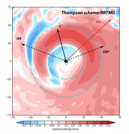
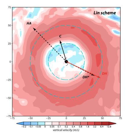
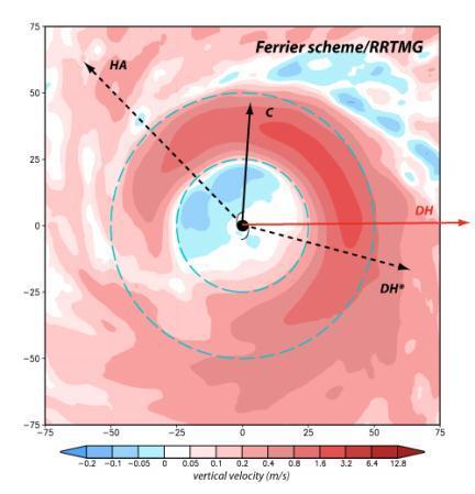
12 Vertically averaged W S2 with RRTM 150 km 50 km Color shaded: vertically averaged vertical velocity (sfc- 500 mb) PV analysis (cf. Wu and Wang 2000): C = storm motion HA = horizontal advection DH = diabatic heating term DH* = DH + VA (vertical advection) C ~ HA+DH* 12

13 Vertically averaged W 13 S2 with RRTM S2 with RRTMG
14 Vertically averaged W Note DH has component against motion S2 with RRTM Note DH has component towards motion T with RRTMG 14
15 Vertically averaged W 15 S2 with RRTM L with RRTM
16 Vertically averaged W 16 S2 with RRTM F with GFDL
17 Vertically averaged W 17 F with RRTM F with GFDL
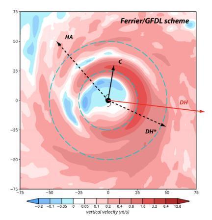


18 Vertically averaged W 18 F with RRTM F with GFDL
19 Discussion Most storms show asymmetric structures broadly consistent with beta shear (e.g. Bender 1997), with enhanced convection on downshear to downshear-left (Frank and Ritchie 1999; Corbosiero and Molinari 2002) Distinct asymmetry patterns may be related to specific microphysical assumptions and interaction with dynamics and other physics These can influence motion, as suggested by the PV analysis Thompson scheme develops a sharply defined asymmetric structure, while Lin scheme structure is more symmetric (as also occurred in real-data simulations of Ike) F/GFDL develops the smallest eye and most sharply defined asymmetry in the vertical velocity field Differences likely emerge most distinctly in cases with little steering and shear 19
20 Vertical cross-sections for the semi-idealized storms Symmetric components in radius-height space, averaged between h no correct answer 20
21 18 km 400 km Diabatic heating from microphysics (color shaded; K/h) Symmetric components of Radial velocity (color shaded; K/h) 21 Note the microphysics heating color shading interval is log 2 scaled
22 C C W Diabatic heating from microphysics (color shaded; K/h) Diabatic heating from radiation (0.1 K/h contours) Symmetric components of Radial velocity (color shaded; K/h) Tangential velocity (10 m/s contours; 20 m/s highlighted) 22 Diabatic heating from radiation combines LW and SW
23 C Diabatic heating from microphysics (color shaded; K/h) Symmetric components of Tangential velocity (color shaded; K/h) Radial velocity (contoured; m/s) Diabatic heating from radiation (contoured; K/h) F/GFDL has almost no cloud-radiative interaction 23
24 C Diabatic heating from microphysics (color shaded; K/h) Diabatic heating from radiation (contoured; K/h) Symmetric components of Tangential velocity (color shaded; K/h) Radial velocity (contoured; m/s) 24
")
 Symmetric")
 Radial")
25 C Diabatic heating from microphysics (color shaded; K/h) Diabatic heating from radiation (contoured; K/h) Symmetric components of Tangential velocity (color shaded; K/h) Radial velocity (contoured; m/s) 25
26 Tracks after spin-up period Tracks following 36 h spin-up period Focus mainly on simulations based on S2 and F S2: RRTM S2@: RRTMG F: RRTM F@: RRTMG F%: RRTM w/ snow seen as cloud ice F/GFDL 26 Microphysics schemes were active from model start. Storm positions relocated after 36 h spin-up period (cosmetic only)
27 Real-data simulations with HWRF 2011 Code and Earl (2010) test case from DTC, vortex-following composites made between h 27
 Tangential velocity (10 m/s contours; 20 m/s highlighted) 28 F/GFDL also has almost no cloud-radiative interaction in the 2011 version of")
28 18 km C W 400 km Vertical velocity (color shaded; m/s) Symmetric components of Radial velocity (color shaded; K/h) Diabatic heating from radiation (0.1 K/h contours) Tangential velocity (10 m/s contours; 20 m/s highlighted) 28 F/GFDL also has almost no cloud-radiative interaction in the 2011 version of HWRF
 but not the LW scheme.")
29 Composite cloud water field 6 km LW+SW 622 km GFDL radiation scheme does see shallow clouds but not deep ones. The SW scheme does respond to thin ice clouds (not shown) but not the LW scheme. 29


30 Vertically averaged W, hours F/GFDL F/RRTM observed shear vector Shear according to AMSU-derived products Little influence of radiation scheme on structure or motion in the Earl test case. 30


31 Vertically averaged W, hours F/GFDL F/RRTM observed shear vector Shear according to AMSU-derived products Even the bogus initial vortex had relatively little impact on the Earl test case (motion, structure, asymmetry). 31
32 Real-data simulations with WRF-ARW Ike (2008) 9 September 12Z, 9 km fixed and 3 km moving nests cold start from GFS with no initial condition modification vortex-following composites made between h 32
33 Legend for next slide 9 & 3 km WRF-ARW forecasts: L/RRTM F/RRTM 36 km WRF-ARW forecasts: L/KF Other tracks GFDL OFCL Ike best track 33

 position errors")
34 NHC multi-model ensemble (revisit slide #4) J. Vigh, NCAR Critical period appears to be between h During that time, F/RRTM moves too slowly, too far west, as does OFCL forecast GFDL track is good but motion is too fast Many of the NHC consensus models evinced similar (or worse) position errors Original 36 km L/KF track is competitive (!) 34

35 W and PV analysis (sfc-10 km) 100 km actual eye diameter 250 km F/RRTM is weaker and shallower. DH* appears to encourage more westerly motion. L/RRTM is deeper and somewhat more symmetric. DH* acts in direction of motion. 35
 condensation field than graupel-dominated L/RRTM. 36")
36 Total column condensate 30-48h 300 km 430 km F/RRTM produces a much wider (and more realistic) condensation field than graupel-dominated L/RRTM. 36
37 Discussion/summary GFDL radiation scheme appears to ignore deep clouds In WRF-ARW and apparently in HWRF (2011) as well It is not clear (to us) what the magnitudes of radiative heating and cooling forced by clouds should be Different model physics appears to encourage distinct symmetric and asymmetric structures that can influence storm motion and may provide means of validating, modifying model physics Working towards examining other cases, and alternate model physics (as available) 37
38 Wu and Wang (2000, JAS) PV analysis HA = horizontal advection VA = vertical advection DH = diabatic heating term extracts wavenumber 1 component 38
Impact of cloud-radiative processes on hurricane track
 GEOPHYSICAL RESEARCH LETTERS, VOL.???, XXXX, DOI:10.1029/, Impact of cloud-radiative processes on hurricane track Robert G. Fovell, 1 Kristen L. Corbosiero, 1 Axel Seifert, 2 Kuo-Nan Liou, 1 Kristen L.
2012 AHW Stream 1.5 Retrospective Results
 2012 AHW Stream 1.5 Retrospective Results Ryan D. Torn, Univ. Albany, SUNY Chris Davis, Wei Wang, Jimy Dudhia, Tom Galarneau, Chris Snyder, James Done, NCAR/NESL/MMM Overview Since participation in HFIP
Advanced Research WRF High Resolution Simulations of Hurricanes Katrina, Rita and Wilma (2005)
") Advanced Research WRF High Resolution Simulations of Hurricanes Katrina, Rita and Wilma (2005) Kristen L. Corbosiero, Wei Wang, Yongsheng Chen, Jimy Dudhia and Christopher Davis National Center for Atmospheric
Advanced Research WRF High Resolution Simulations of Hurricanes Katrina, Rita and Wilma (2005) Kristen L. Corbosiero, Wei Wang, Yongsheng Chen, Jimy Dudhia and Christopher Davis National Center for Atmospheric
Overview of HFIP FY10 activities and results
 Overview of HFIP FY10 activities and results Bob Gall HFIP Annual Review Meeting Miami Nov 9, 2010 Outline In this presentation I will show a few preliminary results from the summer program. More detail
Impact of cloud microphysics on hurricane track forecasts
 Click Here for Full Article GEOPHYSICAL RESEARCH LETTERS, VOL. 34, L24810, doi:10.1029/2007gl031723, 2007 Impact of cloud microphysics on hurricane track forecasts Robert G. Fovell 1 and Hui Su 2 Received
HWRF sensitivity to cumulus schemes
 HWRF sensitivity to cumulus schemes Mrinal K Biswas and Ligia R Bernardet HFIP Telecon, 01 February 2012 Motivation HFIP Regional Model Team Physics Workshop (Aug 11): Foci: Scientific issues on PBL and
Chapter 11. Influence of Cloud Microphysics and Radiation on Tropical Cyclone Structure and Motion
 JOBNAME: AMSM 00#00 2015 PAGE: 1 SESS: 8 OUTPUT: Wed Sep 23 20:25:36 2015 Total No. of Pages: 27 MONTH 2015 F O V E L L E T A L. 1 Chapter 11 Influence of Cloud Microphysics and Radiation on Tropical Cyclone
A Study of Convective Initiation Failure on 22 Oct 2004
 A Study of Convective Initiation Failure on 22 Oct 2004 Jennifer M. Laflin Philip N. Schumacher NWS Sioux Falls, SD August 6 th, 2011 Introduction Forecasting challenge: strong forcing for ascent and large
Influence of Cloud Radiative Forcing on Tropical Cyclone Structure
 1644 J O U R N A L O F T H E A T M O S P H E R I C S C I E N C E S VOLUME 71 Influence of Cloud Radiative Forcing on Tropical Cyclone Structure YIZHE PEGGY BU AND ROBERT G. FOVELL Department of Atmospheric
Post Processing of Hurricane Model Forecasts
 Post Processing of Hurricane Model Forecasts T. N. Krishnamurti Florida State University Tallahassee, FL Collaborators: Anu Simon, Mrinal Biswas, Andrew Martin, Christopher Davis, Aarolyn Hayes, Naomi
Transition of Research to Operations
 Transition of Research to Operations Ligia Bernardet Shaowu Bao, Mrinal Biswas, Tim Brown, Don Stark, Laurie Carson http://www.dtcenter.org/hurrwrf/users External collaborators: NOAA Environmental Modeling
Numerical Weather Prediction: Data assimilation. Steven Cavallo
 Numerical Weather Prediction: Data assimilation Steven Cavallo Data assimilation (DA) is the process estimating the true state of a system given observations of the system and a background estimate. Observations
Meteorology Lecture 24
 Meteorology Lecture 24 Robert Fovell rfovell@albany.edu 1 Important notes These slides show some figures and videos prepared by Robert G. Fovell (RGF) for his Meteorology course, published by The Great
Precipitation Structure and Processes of Typhoon Nari (2001): A Modeling Propsective
: A Modeling Propsective") Precipitation Structure and Processes of Typhoon Nari (2001): A Modeling Propsective Ming-Jen Yang Institute of Hydrological Sciences, National Central University 1. Introduction Typhoon Nari (2001) struck
Precipitation Structure and Processes of Typhoon Nari (2001): A Modeling Propsective Ming-Jen Yang Institute of Hydrological Sciences, National Central University 1. Introduction Typhoon Nari (2001) struck
608 SENSITIVITY OF TYPHOON PARMA TO VARIOUS WRF MODEL CONFIGURATIONS
 608 SENSITIVITY OF TYPHOON PARMA TO VARIOUS WRF MODEL CONFIGURATIONS Phillip L. Spencer * and Brent L. Shaw Weather Decision Technologies, Norman, OK, USA Bonifacio G. Pajuelas Philippine Atmospheric,
ARW/EnKF performance for the 2009 Hurricane Season
 ARW/EnKF performance for the 2009 Hurricane Season Ryan D. Torn, Univ. at Albany, SUNY Chris Davis, Steven Cavallo, Chris Snyder, Wei Wang, James Done, NCAR/MMM 4 th EnKF Workshop 8 April 2010, Rensselaerville,
Motivation & Goal. We investigate a way to generate PDFs from a single deterministic run
 Motivation & Goal Numerical weather prediction is limited by errors in initial conditions, model imperfections, and nonlinearity. Ensembles of an NWP model provide forecast probability density functions
Advanced Hurricane WRF (AHW) Physics
 Physics") Advanced Hurricane WRF (AHW) Physics Jimy Dudhia MMM Division, NCAR 1D Ocean Mixed-Layer Model 1d model based on Pollard, Rhines and Thompson (1973) was added for hurricane forecasts Purpose is to represent
Advanced Hurricane WRF (AHW) Physics Jimy Dudhia MMM Division, NCAR 1D Ocean Mixed-Layer Model 1d model based on Pollard, Rhines and Thompson (1973) was added for hurricane forecasts Purpose is to represent
Comparison of Typhoon Track Forecast using Dynamical Initialization Schemeinstalled
 IWTC-LP 9 Dec 2014, Jeju, Korea Comparison of Typhoon Track Forecast using Dynamical Initialization Schemeinstalled WRF Hyeonjin Shin, WooJeong Lee, KiRyong Kang, 1) Dong-Hyun Cha and Won-Tae Yun National
Sensitivity of precipitation forecasts to cumulus parameterizations in Catalonia (NE Spain)
") Sensitivity of precipitation forecasts to cumulus parameterizations in Catalonia (NE Spain) Jordi Mercader (1), Bernat Codina (1), Abdelmalik Sairouni (2), Jordi Cunillera (2) (1) Dept. of Astronomy and
Sensitivity of precipitation forecasts to cumulus parameterizations in Catalonia (NE Spain) Jordi Mercader (1), Bernat Codina (1), Abdelmalik Sairouni (2), Jordi Cunillera (2) (1) Dept. of Astronomy and
Improved rainfall and cloud-radiation interaction with Betts-Miller-Janjic cumulus scheme in the tropics
 Improved rainfall and cloud-radiation interaction with Betts-Miller-Janjic cumulus scheme in the tropics Tieh-Yong KOH 1 and Ricardo M. FONSECA 2 1 Singapore University of Social Sciences, Singapore 2
18A.2 PREDICTION OF ATLANTIC TROPICAL CYCLONES WITH THE ADVANCED HURRICANE WRF (AHW) MODEL
 MODEL") 18A.2 PREDICTION OF ATLANTIC TROPICAL CYCLONES WITH THE ADVANCED HURRICANE WRF (AHW) MODEL Jimy Dudhia *, James Done, Wei Wang, Yongsheng Chen, Qingnong Xiao, Christopher Davis, Greg Holland, Richard Rotunno,
18A.2 PREDICTION OF ATLANTIC TROPICAL CYCLONES WITH THE ADVANCED HURRICANE WRF (AHW) MODEL Jimy Dudhia *, James Done, Wei Wang, Yongsheng Chen, Qingnong Xiao, Christopher Davis, Greg Holland, Richard Rotunno,
Sensitivity of tropical cyclone Jal simulations to physics parameterizations
 Sensitivity of tropical cyclone Jal simulations to physics parameterizations R Chandrasekar and C Balaji Department of Mechanical Engineering, Indian Institute of Technology, Madras, Chennai 6 36, India.
Transitioning Physics Advancements into the Operational Hurricane WRF Model
 Transitioning Physics Advancements into the Operational Hurricane WRF Model KATHRYN NEWMAN, MRINAL BISWAS, LAURIE CARSON N OA A / ESR L T EA M M E M B E RS: E. K ALINA, J. F RIMEL, E. GRELL, AND L. B ERNARDET
ABSTRACT 2 DATA 1 INTRODUCTION
 16B.7 MODEL STUDY OF INTERMEDIATE-SCALE TROPICAL INERTIA GRAVITY WAVES AND COMPARISON TO TWP-ICE CAM- PAIGN OBSERVATIONS. S. Evan 1, M. J. Alexander 2 and J. Dudhia 3. 1 University of Colorado, Boulder,
Typhoon Relocation in CWB WRF
 Typhoon Relocation in CWB WRF L.-F. Hsiao 1, C.-S. Liou 2, Y.-R. Guo 3, D.-S. Chen 1, T.-C. Yeh 1, K.-N. Huang 1, and C. -T. Terng 1 1 Central Weather Bureau, Taiwan 2 Naval Research Laboratory, Monterey,
Tue 3/1/2016. Arakawa-Schubert, Grell, Tiedtke, Zhang-McFarlane Explicit convection Review for MT exam
 Tue 3/1/2016 Convective parameterization: Arakawa-Schubert, Grell, Tiedtke, Zhang-McFarlane Explicit convection Review for MT exam Reminders/announcements: - Midterm Thu 3/3 (2014 exam posted on www page)
P Hurricane Danielle Tropical Cyclogenesis Forecasting Study Using the NCAR Advanced Research WRF Model
 P1.2 2004 Hurricane Danielle Tropical Cyclogenesis Forecasting Study Using the NCAR Advanced Research WRF Model Nelsie A. Ramos* and Gregory Jenkins Howard University, Washington, DC 1. INTRODUCTION Presently,
A comparative study on the genesis of North Indian Ocean cyclone Madi (2013) and Atlantic Ocean cyclone Florence (2006)
 and Atlantic Ocean cyclone Florence (2006)") A comparative study on the genesis of North Indian Ocean cyclone Madi (2013) and Atlantic Ocean cyclone Florence (2006) VPM Rajasree 1, Amit P Kesarkar 1, Jyoti N Bhate 1, U Umakanth 1 Vikas Singh 1 and
A comparative study on the genesis of North Indian Ocean cyclone Madi (2013) and Atlantic Ocean cyclone Florence (2006) VPM Rajasree 1, Amit P Kesarkar 1, Jyoti N Bhate 1, U Umakanth 1 Vikas Singh 1 and
Key Laboratory of Mesoscale Severe Weather, Ministry of Education, School of Atmospheric Sciences, Nanjing University
 Modeling Rapid Intensification of Typhoon Saomai (2006) with the Weather Research and Forecasting Model and Sensitivity to Cloud Microphysical Parameterizations Jie Ming and Yuan Wang Key Laboratory of
Corresponding author address: Yu Wang, 3141 Turlington Hall, University of Florida, Gainesville, FL
 178 SIMULATING EFFECTS OF LAND SURFACE CHARACTERS ON TPOPICAL CYCLONE RAINFALL PATTERN USING HURRICANE NATURE RUN (HNR) AND WEATHER RESEARCH FORECASTING (WRF) MODEL Yu Wang 1, Jingyin Tang, Corene Matyas
The Impacts of GPSRO Data Assimilation and Four Ices Microphysics Scheme on Simulation of heavy rainfall Events over Taiwan during June 2012
 The Impacts of GPSRO Data Assimilation and Four Ices Microphysics Scheme on Simulation of heavy rainfall Events over Taiwan during 10-12 June 2012 Pay-Liam LIN, Y.-J. Chen, B.-Y. Lu, C.-K. WANG, C.-S.
Evolution of the GFDL hurricane model in research and transition to NMC operations
 Evolution of the GFDL hurricane model in research and transition to NMC operations Robert E. Tuleya (Saic, EMC & CCPO/ODU) Morris Bender (GFDL) Isaac Ginis (URI) Tim Marchok (GFDL) URI/GSO Y. Kurihara
High-Resolution Simulation of Hurricane Bonnie (1998). Part I: The Organization of Eyewall Vertical Motion
. Part I: The Organization of Eyewall Vertical Motion") JANUARY 2006 BRAUN ET AL. 19 High-Resolution Simulation of Hurricane Bonnie (1998). Part I: The Organization of Eyewall Vertical Motion SCOTT A. BRAUN Mesoscale Atmospheric Processes Branch, Laboratory
JANUARY 2006 BRAUN ET AL. 19 High-Resolution Simulation of Hurricane Bonnie (1998). Part I: The Organization of Eyewall Vertical Motion SCOTT A. BRAUN Mesoscale Atmospheric Processes Branch, Laboratory
Tropical cyclones in ver/cal shear: dynamic, kinema/c, and thermodynamic aspects of intensity modification
 Tropical cyclones in ver/cal shear: dynamic, kinema/c, and thermodynamic aspects of intensity modification Michael Riemer 1, Michael T. Montgomery 2,3, Mel E. Nicholls 4 1 Johannes Gutenberg-Universität,
Cloud Microphysics Impact on Hurricane Track as Revealed in Idealized Experiments
 1764 J O U R N A L O F T H E A T M O S P H E R I C S C I E N C E S VOLUME 66 Cloud Microphysics Impact on Hurricane Track as Revealed in Idealized Experiments ROBERT G. FOVELL AND KRISTEN L. CORBOSIERO
Thunderstorm-Scale EnKF Analyses Verified with Dual-Polarization, Dual-Doppler Radar Data
 Thunderstorm-Scale EnKF Analyses Verified with Dual-Polarization, Dual-Doppler Radar Data David Dowell and Wiebke Deierling National Center for Atmospheric Research, Boulder, CO Ensemble Data Assimilation
Di Wu, Xiquan Dong, Baike Xi, Zhe Feng, Aaron Kennedy, and Gretchen Mullendore. University of North Dakota
 Di Wu, Xiquan Dong, Baike Xi, Zhe Feng, Aaron Kennedy, and Gretchen Mullendore University of North Dakota Objectives 3 case studies to evaluate WRF and NAM performance in Oklahoma (OK) during summer 2007,
The Energetics of the Rapid Intensification of Hurricane Earl (2010) Daniel Nielsen
 Daniel Nielsen") The Energetics of the Rapid Intensification of Hurricane Earl (2010) Daniel Nielsen A scholarly paper in partial fulfillment of the requirements for the degree of Master of Science August 2016 Department
The Energetics of the Rapid Intensification of Hurricane Earl (2010) Daniel Nielsen A scholarly paper in partial fulfillment of the requirements for the degree of Master of Science August 2016 Department
Toshi Matsui, Taka Iguchi, and Wei-Kuo Tao NASA GSFC Code 612 ESSIC UMD
 Precipitation Variability and Diurnal Cycle of Convection- Permitting Deterministic Simulations versus Mesoscale Multi-Physics Ensemble Simulations: A Preliminary Result from the NASA Downscaling Project
A Reformulation of the Logistic Growth Equation Model (LGEM) for Ensemble and Extended Range Intensity Prediction
 for Ensemble and Extended Range Intensity Prediction") A Reformulation of the Logistic Growth Equation Model (LGEM) for Ensemble and Extended Range Intensity Prediction Mark DeMaria NOAA/NESDIS, Fort Collins, CO Andrea Schumacher and Kate Musgrave CIRA/CSU,
A Reformulation of the Logistic Growth Equation Model (LGEM) for Ensemble and Extended Range Intensity Prediction Mark DeMaria NOAA/NESDIS, Fort Collins, CO Andrea Schumacher and Kate Musgrave CIRA/CSU,
Microphysics Schemes in EMC s Operational Hurricane Models
 Microphysics Schemes in EMC s Operational Hurricane Models Brad Ferrier, Weiguo Wang, Eric Aligo 1,2 1 Environment Modeling Center (EMC)/NCEP/NWS 2 I.M. Systems Group, Inc. HFIP Physics Workshop 9 11 August
Mélicie Desflots* RSMAS, University of Miami, Miami, Florida
 15B.6 RAPID INTENSITY CHANGE IN HURRICANE LILI (2002) Mélicie Desflots* RSMAS, University of Miami, Miami, Florida 1. INTRODUCTION Rapid intensity change in tropical cyclones is one of the most difficult
Variational data assimilation of lightning with WRFDA system using nonlinear observation operators
 Variational data assimilation of lightning with WRFDA system using nonlinear observation operators Virginia Tech, Blacksburg, Virginia Florida State University, Tallahassee, Florida rstefane@vt.edu, inavon@fsu.edu
High-Res Physics Tiger Team Report
 High-Res Physics Tiger Team Report Lin Zhu,Sergio Abarca & all EMC hurricane team, Robert Fovell, Jun Zhan, Ping Zhu, Shaowu Bao, Ligia Bernadet, Kathryn Newman, Evan Kalina, Mirnal Biswas, Avichal Mehra,
School of Atmospheric Sciences, Sun Yat-sen University, Guangzhou , China 2
 1 2 3 4 5 6 7 8 9 10 Article Sensitivity of Different Parameterizations on Simulation of Tropical Cyclone Durian over the South China Sea using Weather Research and Forecasting (WRF) model Worachat Wannawong
Kelly Mahoney NOAA ESRL Physical Sciences Division
 The role of gray zone convective model physics in highresolution simulations of the 2013 Colorado Front Range Flood WRF model simulated precipitation over terrain in CO Front Range Kelly Mahoney NOAA ESRL
PSU HFIP 2010 Summary: Performance of the ARW-EnKF Real-time Cloud-resolving TC Ensemble Analysis and Forecasting System.
 PSU HFIP 2010 Summary: Performance of the ARW-EnKF Real-time Cloud-resolving TC Ensemble Analysis and Forecasting System Fuqing Zhang Penn State University Contributors: Yonghui Weng, John Gamache and
Assimilation of GPS RO Data for Tropical Cyclone Prediction with HWRF Chunhua Zhou1, Hui Shao1, Bill Kuo1 and Ligia Bernardet2
 Assimilation of GPS RO Data for Tropical Cyclone Prediction with HWRF Chunhua Zhou1, Hui Shao1, Bill Kuo1 and Ligia Bernardet2 1 National Center for Atmospheric Research (NCAR) 2 NOAA/ESRL/GSD Sixth FORMOSAT-3/COSMIC
COAMPS-TC 2015 Version, Performance, and Future Plans
 COAMPS-TC 2015 Version, Performance, and Future Plans James D. Doyle, R. Hodur 1, J. Moskaitis, S. Chen, E. Hendricks 2, H. Jin, Y. Jin, A. Reinecke, S. Wang Naval Research Laboratory, Monterey, CA 1 IES/SAIC,
The Developmental Testbed Center (DTC) Steve Koch, NOAA/FSL
 Steve Koch, NOAA/FSL") The Developmental Testbed Center (DTC) Steve Koch, NOAA/FSL A facility where the NWP research and operational communities interact to accelerate testing and evaluation of new models and techniques for
The Developmental Testbed Center (DTC) Steve Koch, NOAA/FSL A facility where the NWP research and operational communities interact to accelerate testing and evaluation of new models and techniques for
Weather Research and Forecasting Model. Melissa Goering Glen Sampson ATMO 595E November 18, 2004
 Weather Research and Forecasting Model Melissa Goering Glen Sampson ATMO 595E November 18, 2004 Outline What does WRF model do? WRF Standard Initialization WRF Dynamics Conservation Equations Grid staggering
16D.4 Evaluating HWRF Forecasts of Tropical Cyclone Intensity and Structure in the North Atlantic Basin
 16D.4 Evaluating HWRF Forecasts of Tropical Cyclone Intensity and Structure in the North Atlantic Basin Dany Tran* and Sen Chiao Meteorology and Climate Science San Jose State University, San Jose, California
Tropical Cyclone Track Prediction
 Tropical Cyclone Track Prediction Richard J. Pasch and David A. Zelinsky National Hurricane Center 2016 RA-IV Workshop on Hurricane Forecasting and Warning March 8, 2016 Outline Basic Dynamics Guidance
Tropical cyclone simulations and predictions with GFDL s prototype global cloud resolving model
 Tropical cyclone simulations and predictions with GFDL s prototype global cloud resolving model S.-J. Lin and GFDL model development teams NOAA/Geophysical Fluid Dynamics Laboratory Workshop on High-Resolution
Assessing the Impacts of Different WRF Precipitation Physics in Hurricane Simulations
 AUGUST 2012 N A S R O L L A H I E T A L. 1003 Assessing the Impacts of Different WRF Precipitation Physics in Hurricane Simulations NASRIN NASROLLAHI, AMIR AGHAKOUCHAK, JIALUN LI, XIAOGANG GAO, KUOLIN
A pseudo-ensemble hybrid data assimilation system for HWRF
 A pseudo-ensemble hybrid data assimilation system for HWRF Xuyang Ge UCAR visiting postdoctoral scientist at PSU/NCEP Contributors: Fuqing Zhang and Yonghui Weng (PSU) Mingjing Tong and Vijay Tallapragada
OPERATIONAL CONSIDERATIONS FOR HURRICANE MODEL DIAGNOSTICS / VERIFICATION
 OPERATIONAL CONSIDERATIONS FOR HURRICANE MODEL DIAGNOSTICS / VERIFICATION Richard J. Pasch National Hurricane Center Hurricane Diagnostics and Verification Workshop Miami, Florida 4 May 2009 NOAA/NESDIS
Tropical Cyclone Formation: Results
 Tropical Cyclone Formation: Results from PREDICT (PRE Depression Investigation of Cloud systems in the Tropics) collaborator on this presentation: Dave Ahijevych (NCAR) Chris Davis National Center for
Impact of subgrid-scale vertical turbulent mixing on eyewall asymmetric structures and mesovortices of hurricanes
 Quarterly Journal of the Royal Meteorological Society Q. J. R. Meteorol. Soc. : 38, January B Impact of subgrid-scale vertical turbulent mixing on eyewall asymmetric structures and mesovortices of hurricanes
CORDEX Simulations for South Asia
 WCRP CORDEX South Asia Planning Meeting 25-26 February 2012 Indian Institute of Tropical Meteorology (IITM) Pune, India CORDEX Simulations for South Asia J. Sanjay Centre for Climate Change Research (CCCR)
The Fifth-Generation NCAR / Penn State Mesoscale Model (MM5) Mark Decker Feiqin Xie ATMO 595E November 23, 2004 Department of Atmospheric Science
 Mark Decker Feiqin Xie ATMO 595E November 23, 2004 Department of Atmospheric Science") The Fifth-Generation NCAR / Penn State Mesoscale Model (MM5) Mark Decker Feiqin Xie ATMO 595E November 23, 2004 Department of Atmospheric Science Outline Basic Dynamical Equations Numerical Methods Initialization
The Fifth-Generation NCAR / Penn State Mesoscale Model (MM5) Mark Decker Feiqin Xie ATMO 595E November 23, 2004 Department of Atmospheric Science Outline Basic Dynamical Equations Numerical Methods Initialization
Downscaling West African climate: uncertainties, sensitivity to the model physics and regional variability
 Downscaling West African climate: uncertainties, sensitivity to the model physics and regional variability Benjamin Pohl, Johanna Ramarohetra, Benjamin Sultan, Arona Diedhiou, Gaëlle de Coëtlogon, Serge
Dynamic Ensemble Model Evaluation of Elevated Thunderstorms sampled by PRECIP
 Dynamic Ensemble Model Evaluation of Elevated Thunderstorms sampled by PRECIP Joshua S. Kastman, Patrick S. Market, and Neil Fox, University of Missouri, Columbia, MO Session 8B - Numerical Weather Prediction
An Overview of COAMPS-TC Development and Real-Time Tests
 An Overview of COAMPS-TC Development and Real-Time Tests James D. Doyle, R. Hodur 1, P. Black, S. Chen, J. Cummings 2, E. Hendricks, T. Holt, H. Jin, Y. Jin, C.-S. Liou, J. Moskaitis, M. Peng, A. Reinecke,
AHW Ensemble Data Assimilation and Forecasting System
 AHW Ensemble Data Assimilation and Forecasting System Ryan D. Torn, Univ. Albany, SUNY Chris Davis, Wei Wang, Jimy Dudhia, Tom Galarneau, Chris Snyder, James Done, NCAR/MMM Overview Since participation
Comparison of Convection-permitting and Convection-parameterizing Ensembles
 Comparison of Convection-permitting and Convection-parameterizing Ensembles Adam J. Clark NOAA/NSSL 18 August 2010 DTC Ensemble Testbed (DET) Workshop Introduction/Motivation CAMs could lead to big improvements
Interactions between Simulated Tropical Cyclones and an Environment with a Variable Coriolis Parameter
 MAY 2007 R I TCHIE AND FRANK 1889 Interactions between Simulated Tropical Cyclones and an Environment with a Variable Coriolis Parameter ELIZABETH A. RITCHIE Department of Electrical and Computer Engineering,
HMON (HNMMB): Development of a new Hurricane model for NWS/NCEP operations
: Development of a new Hurricane model for NWS/NCEP operations") 1 HMON (HNMMB): Development of a new Hurricane model for NWS/NCEP operations Avichal Mehra, EMC Hurricane and Mesoscale Teams Environmental Modeling Center NOAA / NWS / NCEP HMON: A New Operational Hurricane
1 HMON (HNMMB): Development of a new Hurricane model for NWS/NCEP operations Avichal Mehra, EMC Hurricane and Mesoscale Teams Environmental Modeling Center NOAA / NWS / NCEP HMON: A New Operational Hurricane
Satellite Applications to Hurricane Intensity Forecasting
 Satellite Applications to Hurricane Intensity Forecasting Christopher J. Slocum - CSU Kate D. Musgrave, Louie D. Grasso, and Galina Chirokova - CIRA/CSU Mark DeMaria and John Knaff - NOAA/NESDIS Center
Effects of Convective Heating on Movement and Vertical Coupling of Tropical Cyclones: A Numerical Study*
 3639 Effects of Convective Heating on Movement and Vertical Coupling of Tropical Cyclones: A Numerical Study* LIGUANG WU ANDBIN WANG Department of Meteorology, School of Ocean and Earth Science and Technology,
Impact of Physics Representations in the HWRFX on Simulated Hurricane Structure and Pressure Wind Relationships
 3278 M O N T H L Y W E A T H E R R E V I E W VOLUME 140 Impact of Physics Representations in the HWRFX on Simulated Hurricane Structure and Pressure Wind Relationships J.-W. BAO NOAA/ESRL, Boulder, Colorado
A New Ocean Mixed-Layer Model Coupled into WRF
 ATMOSPHERIC AND OCEANIC SCIENCE LETTERS, 2012, VOL. 5, NO. 3, 170 175 A New Ocean Mixed-Layer Model Coupled into WRF WANG Zi-Qian 1,2 and DUAN An-Min 1 1 The State Key Laboratory of Numerical Modeling
Impact of GPS RO Data on the Prediction of Tropical Cyclones
 Impact of GPS RO Data on the Prediction of Tropical Cyclones Ying-Hwa Kuo, Hui Liu, UCAR Ching-Yuang Huang, Shu-Ya Chen, NCU Ling-Feng Hsiao, Ming-En Shieh, Yu-Chun Chen, TTFRI Outline Tropical cyclone
GFDL Hurricane Model Ensemble Performance During the 2012 Hurricane Season
 GFDL Hurricane Model Ensemble Performance During the 2012 Hurricane Season Tim Marchok (NOAA / GFDL) Matt Morin (DRC HPTG / GFDL) Morris Bender (NOAA / GFDL) HFIP Team Telecon 12 December 2012 Acknowledgments:
NUMERICAL SIMULATION OF A BAY OF BENGAL TROPICAL CYCLONE: A COMPARISON OF THE RESULTS FROM EXPERIMENTS WITH JRA-25 AND NCEP REANALYSIS FIELDS
 NUMERICAL SIMULATION OF A BAY OF BENGAL TROPICAL CYCLONE: A COMPARISON OF THE RESULTS FROM EXPERIMENTS WITH JRA-25 AND NCEP REANALYSIS FIELDS Dodla Venkata Bhaskar Rao Desamsetti Srinivas and Dasari Hari
A Numerical Study of the Impact of Vertical Shear on the Distribution of Rainfall in Hurricane Bonnie (1998)
") AUGUST 2003 ROGERS ET AL. 1577 A Numerical Study of the Impact of Vertical Shear on the Distribution of Rainfall in Hurricane Bonnie (1998) ROBERT ROGERS Cooperative Institute for Marine and Atmospheric
AUGUST 2003 ROGERS ET AL. 1577 A Numerical Study of the Impact of Vertical Shear on the Distribution of Rainfall in Hurricane Bonnie (1998) ROBERT ROGERS Cooperative Institute for Marine and Atmospheric
1. Introduction. In following sections, a more detailed description of the methodology is provided, along with an overview of initial results.
 7B.2 MODEL SIMULATED CHANGES IN TC INTENSITY DUE TO GLOBAL WARMING Kevin A. Hill*, Gary M. Lackmann, and A. Aiyyer North Carolina State University, Raleigh, North Carolina 1. Introduction The impact of
Applications of future GEO advanced IR sounder for high impact weather forecasting demonstration with regional OSSE
 Applications of future GEO advanced IR sounder for high impact weather forecasting demonstration with regional OSSE Jun Li @, Tim Schmit &, Zhenglong Li @, Feng Zhu @*, Pei Wang @*, Agnes Lim @, and Robert
P1.2 SENSITIVITY OF WRF MODEL FORECASTS TO DIFFERENT PHYSICAL PARAMETERIZATIONS IN THE BEAUFORT SEA REGION
 P1.2 SENSITIVITY OF WRF MODEL FORECASTS TO DIFFERENT PHYSICAL PARAMETERIZATIONS IN THE BEAUFORT SEA REGION Jeremy R. Krieger *, Jing Zhang Arctic Region Supercomputing Center, University of Alaska Fairbanks
Department of Meteorology, University of Utah, Salt Lake City, UT. Second revision. Submitted to Monthly Weather Review.
 Sensitivity of Numerical Simulation of Early Rapid Intensification of Hurricane Emily (2005) to Cloud Microphysical and Planetary Boundary Layer Parameterizations XUANLI LI and ZHAOXIA PU * Department
Advancements in Operations and Research on Hurricane Modeling and Ensemble Prediction System at EMC/NOAA
 Advancements in Operations and Research on Hurricane Modeling and Ensemble Prediction System at EMC/NOAA Zhan Zhang and Vijay Tallapragada EMC/NCEP/NOAA/DOC Acknowledgements: HWRF Team Members at EMC,
Upsidence wave during VOCALS. David A. Rahn and René Garreaud Department of Geophysics Universidad de Chile
 Upsidence wave during VOCALS David A. Rahn and René Garreaud Department of Geophysics Universidad de Chile Upsidence Wave Garreaud and Muñoz (2004, GM04) A robust diurnal cycle of vertical motion between
Recent COAMPS-TC Development and Future Plans
 Recent COAMPS-TC Development and Future Plans James D. Doyle, Jon Moskaitis, Rich Hodur1, Sue Chen, Hao Jin, Yi Jin, Will Komaromi, Alex Reinecke, David Ryglicki, Dan Stern2, Shouping Wang Naval Research
Upsidence wave during VOCALS. David A. Rahn and René Garreaud Department of Geophysics Universidad de Chile
 Upsidence wave during VOCALS David A. Rahn and René Garreaud Department of Geophysics Universidad de Chile Upsidence Wave Garreaud and Muñoz (2004, GM04) A robust diurnal cycle of vertical motion between
Ensemble Prediction Systems
 Ensemble Prediction Systems Eric Blake National Hurricane Center 7 March 2017 Acknowledgements to Michael Brennan 1 Question 1 What are some current advantages of using single-model ensembles? A. Estimates
BASIN-SCALE HWRF: Evaluation of 2017 Real-Time Forecasts
 BASIN-SCALE HWRF: Evaluation of 2017 Real-Time Forecasts HARVEY IRMA MARIA Ghassan Alaka1,2, Xuejin Zhang1,2, Gopal2, Frank Marks2, Mu-Chieh Ko1,2, Russell St. Fleur1,2 Acknowledgements: NOAA/NWS/EMC,
NCEP Operational Hurricane Modeling System. HWRF Performance Verification in 2015
 1 NCEP Operational Hurricane Modeling System HWRF Performance Verification in 2015 The HWRF Team Environmental Modeling Center, NCEP NOAA/NCWCP, College Park, MD 20740, USA. Zhan Zhang, Samuel Trahan,
A Preliminary Exploration of the Upper Bound of Tropical Cyclone Intensification
 A Preliminary Exploration of the Upper Bound of Tropical Cyclone Intensification Jonathan L. Vigh (NCAR/RAL) Kerry Emanuel (MIT) Mrinal K. Biswas (NCAR/RAL) Eric A. Hendricks (Naval Postgraduate School)
14B.1 Evaluating cloud microphysics schemes in nested NMMB forecasts
 14B.1 Evaluating cloud microphysics schemes in nested NMMB forecasts Brad Ferrier1,2 Weiguo Wang1,2 Edward Colón1,2 NOAA/NWS/NCEP Environmental Modeling Center (EMC) 2 IM Systems Group, Inc. (IMSG) 1 1
WRF Modeling System Overview
 WRF Modeling System Overview Louisa Nance National Center for Atmospheric Research (NCAR) Developmental Testbed Center (DTC) 27 February 2007 1 Outline What is WRF? WRF Modeling System WRF Software Design
TC STRUCTURE GUIDANCE UPDATES
 TC STRUCTURE GUIDANCE UPDATES FROM NESDIS (CO)/CIRA Status and update for the multi-platform tropical cyclone wind analysis (MTCSWA) New microwave-sounder-based intensity and structure estimates New method
Tue 3/29/2016. Representation of clouds and precipitation:
 Tue 3/29/2016 Representation of clouds and precipitation: - Case study example of microphysics test - Bulk parameterizations: Process listing - WRF scheme options Convective parameterization paper summaries
A simulation study on the rapid intensification of Typhoon Megi (2010) in vertical wind shear
 in vertical wind shear") ATMOSPHERIC SCIENCE LETTERS Atmos. Sci. Let. 17: 630 638 (2016) Published online 11 November 2016 in Wiley Online Library (wileyonlinelibrary.com) DOI:.02/asl.713 A simulation study on the rapid intensification
ATMOSPHERIC SCIENCE LETTERS Atmos. Sci. Let. 17: 630 638 (2016) Published online 11 November 2016 in Wiley Online Library (wileyonlinelibrary.com) DOI:.02/asl.713 A simulation study on the rapid intensification
Applications Development and Diagnostics (ADD) Team Summary Part 2
 Team Summary Part 2") Applications Development and Diagnostics (ADD) Team Summary Part 2 Mark DeMaria, NOAA/NESDIS HFIP Annual Review Meeting Nov. 8-9, 2011, Miami, FL Input from: Chris Davis, James Doyle, Thomas Galarneau,
Applications Development and Diagnostics (ADD) Team Summary Part 2 Mark DeMaria, NOAA/NESDIS HFIP Annual Review Meeting Nov. 8-9, 2011, Miami, FL Input from: Chris Davis, James Doyle, Thomas Galarneau,
Tropical cyclones and seasonal means in high-resolution CAM 5 runs.
 Tropical cyclones and seasonal means in high-resolution CAM 5 runs. Julio Bacmeister ( NESL ) NCAR Earth System Laboratory Collaborators/contributors: Peter Lauritzen, Jerry Olson, John Truesdale +CAM-5
8C.6 Idealized simulations of the impact of dry Saharan air on Atlantic hurricanes
 8C.6 Idealized simulations of the impact of dry Saharan air on Atlantic hurricanes Scott A. Braun #, Jason Sippel #, and David Nolan* #Laboratory for Atmospheres, NASA/Goddard Space Flight Center, Greenbelt,
Final Examination, MEA 443 Fall 2008, Lackmann
 Place an X here to count it double! Name: Final Examination, MEA 443 Fall 2008, Lackmann If you wish to have the final exam count double and replace your midterm score, place an X in the box above. As
TC forecasting with variable resolution in CAM-MPAS
 TC forecasting with variable resolution in CAM-MPAS Sang-Hun Park Bill Skamarock, Chris Davis, Jimy Dudhia and Michael Duda collaborators (CGD) :: Peter Lauritzen, Andrew Gettelman and Stephen Yeager National
Development of the Basin-scale HWRF Modeling System
 Development of the Basin-scale HWRF Modeling System Xuejin Zhang and Ghassan Alaka, Jr. (AOML/HRD) HFIP Annual Meeting, 11 January 2017 Team AOML/HRD (Team Lead: S. Gopalakrishnan) G. Alaka R. Black H.